An Unfair Share Exploring the Disproportionate Risks from Climate Change Facing Washington State Communities - University of Washington
←
→
Page content transcription
If your browser does not render page correctly, please read the page content below
An Unfair Share
Exploring the Disproportionate Risks
from Climate Change Facing
Washington State Communities

                                                                                               2018
A report by the University of Washington Climate Impacts Group, Front and Centered, Urban@UW
and the University of Washington Department of Environmental & Occupational Health Sciences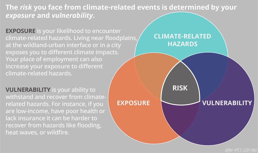
This report was produced as a collaboration of the University of Washington Climate Impacts Group,
University of Washington Department of Environmental and Occupational Health Sciences, Front
and Centered and University of Washington Urban@UW.

This work was supported by Seattle Foundation whose mission is to ignite powerful, rewarding
philanthropy to make Greater Seattle a stronger, more vibrant community for all. Learn more at:
www.seattlefoundation.org.

The research and writing team included:
Joe Casola, University of Washington Climate Impacts Group
Heidi A. Roop*, University of Washington Climate Impacts Group
Katie Fellows, University of Washington Department of Environmental and Occupational Health
Sciences
Vanessa Galaviz, University of Washington Department of Environmental and Occupational Health
Sciences
Deric Gruen, Front and Centered
Sara Jacobs, Urban@UW
Edmund Seto, University of Washington Department of Environmental and Occupational Health
Sciences
*Corresponding author

The research and writing team is greatly appreciative of input received from the Front and Centered
Steering Committee, UW faculty, Seattle Foundation and the community members who hosted and
participated in the Listening Sessions. This input proved central to this report. We acknowledge and
thank Bill Daniell, Jen Davison, Kris Ebi, Nicole Errett, Tania Busch Isaksen, Susan Kemp, Esther Min,
Pah-tu E. Pitt, Sam Sellers, Thaisa Way, and Ken Yocom for their review of draft materials and helpful
comments.

Suggested citation: UW Climate Impacts Group, UW Department of Environmental and
Occupational Health Sciences, Front and Centered and Urban@UW, 2018. An Unfair Share: Exploring
the disproportionate risks from climate change facing Washington state communities. A report prepared
for Seattle Foundation. University of Washington, Seattle.

Cover photos: Community members at listening sessions held across Washington State for this report.
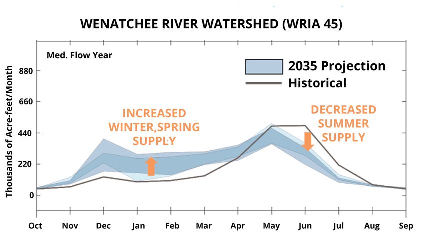
TABLE OF CONTENTS
Executive Summary                                      1

Chapter 1. Introduction                                 4
     What is the purpose of this report?                4
     Why now?                                           5
     Who is this report for?                            6
     Report Overview                                    6

Chapter 2. Report Approach                              9
     Writing Team                                       9
     Community Listening Sessions                       9
     Conceptual Framework for Climate Risk             11
     Racial and Ethnic Diversity in Washington State   13

Chapter 3. Climate Change-Related Hazards              15
     Warming Temperatures                              16
     Water Stress and Drought                          17
     Flooding                                          18
     Wildfire                                          19
     Air Quality                                       19
     Ocean Acidification                               20
     Changes in the Spread of Infectious Disease       20

Chapter 4. Risks based on Place of Residence           21
     Exposure                                          21
            Exposure in Floodplains                    21
            Exposure in the Wildland-Urban Interface   23
            Exposure in Urban Areas                    25
     Factors Affecting Vulnerability                   26
            Race and Ethnicity                         27
            Wealth and Income                          28
            Social Cohesion                            29
            Linguistic Isolation                       31
            Age and Health Status                      31
            Perception of Risk                         32
            Cultural Importance                        32
            Community Infrastructure                   33

Chapter 5. Risks based on Employment and Livelihoods   36
     Exposure                                          36
            Exposure in the Agriculture Sector         36
Exposure in Fisheries                                           39
            Exposure in the Construction Sector                             40
     Factors Affecting Vulnerability                                        41
            Race and Ethnicity                                              41
            Education and Job Mobility                                      42
            Linguistic Isolation                                            43
            Existing Environmental Stressors                                44
            Immigration Status                                              44
            Water Rights                                                    45
            Cultural Importance                                             45

Chapter 6. Community-Responsive Approaches to Building Climate Resilience   46
     Community-driven efforts to Document Climate Impacts and
     Advance Climate Preparedness                                           47
     Efforts to Maintain Traditional Cultural Practices and Resources       48
     Climate/Risk Communication and Educational Materials                   49
     Legislation to Direct Financial Resources to Reducing Climate
     Risks to ‘Disadvantaged’ and ‘Low-Income’ Communities                  50

Chapter 7. Research Gaps                                                    52

Chapter 8. References                                                       56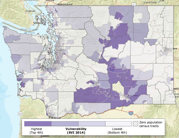
EXECUTIVE SUMMARY
Climate impacts or hazards, stemming from events like heat waves, floods and drought
pose challenges for all Washington communities, now and in the future. However, the
degree to which communities will experience these climate change-related hazards,
described here as exposure, is not the same. Similarly, the extent to which communities can
cope with the impacts of climate change-related hazards, described here as vulnerability,
varies across communities, and even among individuals. Both exposure and vulnerability
ultimately determine an individual’s or community’s level of risk. This hazard-vulnerability-
exposure framework is used in this report for exploring the impacts on communities from
climate change-related hazards in Washington state.

The aim of this report is to support ongoing discussions regarding the climate change-
related hazards facing communities in Washington, with a special emphasis on
communities of color, indigenous peoples and communities with lower incomes. For
climate policies and programs to effectively address existing or future inequities, there
needs to be credible information about who is at risk in Washington state from climate
impacts, and why. This information should clarify how communities may be exposed
differently and how factors like race/ethnicity, wealth, income, level of education and health
status affect the ability to cope with the impacts, or related harms. It should also highlight
the types of community strengths, assets and processes that can build resilience to climate
impacts.

In this report, our research team has identified factors that contribute to disparities in how
communities in Washington state experience and cope with the climate change-related
hazards with a specific focus on where people live and work. This report does not address
‘second order’ impacts from climate hazards experienced elsewhere, such as impacts on
global food systems and trade. This work draws upon two key inputs: 1) comments made
by diverse community members during eleven statewide Listening Sessions, convened with
community-based organizations in 2017, and 2) a review of published research related to
Pacific Northwest climate impacts, public health and disaster planning and response. Key
findings include:

> Local social, economic, demographic and geographic factors ultimately determine
how severe climate change-related risks will likely be. Climate change-related risk often
has more to do with population characteristics such as race/ethnicity, wealth, educational
attainment, occupation, political voice and the strength of community organizations than
with the pace or magnitude of a changing climate. Therefore, communities of color,
indigenous peoples and communities with lower incomes tend to face the greatest climate
risks.

                                                                                            1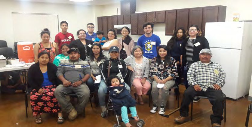
> Where you live and where you work are important factors that contribute to
exposure and vulnerability to climate change-related impacts. A range of climate
change-related hazards will affect key industries across Washington state, but the impacts
will be unevenly felt. The agricultural workforce in Washington state is roughly 53% non-
white and 40% Hispanic/Latinx (U.S. Census Bureau, 2017). Most agricultural workers in
Washington state are male, foreign-born, work long hours, rotate to different employers,
have little formal education, and are more likely to suffer from chronic health problems
(Bethel et al., 2017). In the agricultural sector, upwards of 79% of outdoor farm workers
experience a heat-related illness during the summer harvest season (Bethel et al., 2017;
Spector et al., 2014). See Chapter 5.

> Efforts to build community resilience to climate change in Washington state are
more likely to be effective if they are inclusive and reinforce existing social structures
that promote cohesion. Social cohesion, which is the result of strong social networks,
trusted relationships and shared cultural experiences, can help communities access and
share resources in the face of disasters and emergencies. Shared spaces and community
groups that act as hubs for exchanging information and sharing resources play a critical
role in bolstering resilience. Displacement and division can undermine this social cohesion.

Several extreme weather events in the U.S., which are projected to worsen with climate
change, have demonstrated that social cohesion, or the ability for communities to
communicate, cooperate, access and share resources, can reduce negative consequences
of such events. During a 1995 heat wave in Chicago, Latinx neighborhoods experienced
substantially lower mortality rates than other neighborhoods. The higher resilience of that
community has been ascribed to greater social cohesion within these neighborhoods
(Klinenberg, 2002). See Chapter 4.

Given the placed-based nature of climate change-related risks, community members are
likely to be the experts in developing and deploying solutions that enhance social cohesion,
prevent displacement and bolster community resilience to climate change.

> There are several research gaps where future work is needed to improve our
understanding of the climate change-related risks facing Washington communities.
Climate change-related hazards such as increasing air temperature, flood risk and wildfire
can all negatively impact human health and livelihoods. Unfortunately, there is limited
understanding of which communities across the state are most likely to be exposed and
vulnerable to these hazards. A few examples of existing research gaps, which are explored
in Chapter 7, include:

                                                                                          2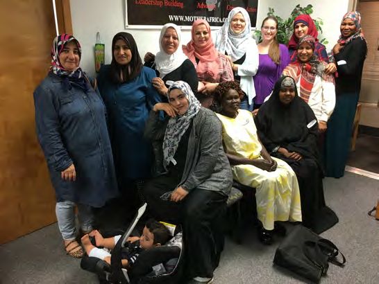
•   Understanding the extent to which climate change-related hazards exacerbate
          threats to health, including mental health conditions, is needed. Emerging
          research indicates that mental health can be affected by extreme heat. Many
          communities of color, indigenous peoples and communities with lower incomes
          already experience health disparities and tend to have more limited access to
          healthcare. Understanding the extent to which climate hazards may exacerbate
          threats to health conditions, like mental health, would be valuable for public
          health professionals, emergency managers and hazard planners.

      •   Examination of community experiences during, and after, specific climate-related
          events like extreme rainfall and flooding would help to deepen our understanding
          of the responses and consequences of such events in Washington state. To go
          beyond the anecdotes collected for this report, more systematic investigation is
          needed of community experiences surrounding extreme events. This type of work
          would identify the relative importance of specific factors that affect community
          vulnerability among Washington state’s different racial/ethnic groups.

      •   Understanding how climate impacts are being managed for port infrastructure
          and surrounding neighborhoods is needed. Ports in Washington state will
          experience more frequent flooding and inundation from sea-level rise.
          Neighborhoods surrounding ports are characteristically non-white and lower-
          income; the confluence of these factors makes ports potentially important
          locations for thinking about greenhouse gas reductions, climate resilience and
          equity issues.

      •   Better understanding the different risks facing urban and rural populations in
          Washington state is needed. How do factors like housing quality, affordability, and
          availability of services in these different contexts contribute to exposure and
          vulnerability to climate change-related hazards?

Understanding how climate impacts intersect with issues of equity and environmental
justice requires using participatory, community-centered research. As a beginning in this
work for Washington state, our project team intentionally brought university students and
researchers together with community groups, creating the occasion and stimulus for
shared learning and exploration of new questions. We hope this contribution is followed by
many more efforts to build closer connections between academic spaces and the
communities in our state. It has never been more critical to combine perspectives and
resources to craft inclusive responses to the emerging risks of climate change.

                                                                                           3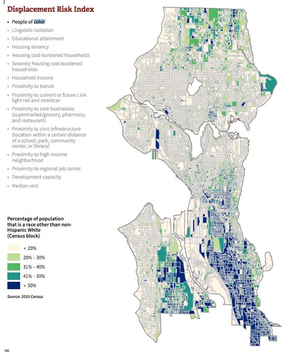
CHAPTER 1. INTRODUCTION

This report highlights the disproportionate climate climate-related hazards facing
communities in the state of Washington, with a focus on communities of color, indigenous
peoples and communities with lower incomes. The content of the report is drawn from on-
the-ground experiences and perspectives of community members, as well as available
published research. The report also identifies knowledge gaps in our collective
understanding of the disproportionate risks facing these frontline communities, as well as
examples of inclusive planning processes that are being pursued to build climate resilience.

        Climate change affects all, but not all are affected
          equally.
                                                                           - Yuen et al., 2017

WHAT IS THE PURPOSE OF THIS REPORT?

> To stimulate more, and deeper, discussion of the human dimensions of climate
impacts, specifically in Washington state. There are several sources of information
about the implications of climate change for Washington state (e.g. Snover et al., 2013;
Mauger et al., 2015) and the Northwest (e.g. Dalton et al., 2013; Mote et al., 2014). However,
these synthesis reports focus heavily on the physical and ecological dimensions of climate
change, and less attention is paid to the demographics, identities, socioeconomic status,
and cultural values of potentially-affected individuals and communities. Also, there is
limited information about the distribution of risk among individuals and communities with
differing demographics, identities, socioeconomic status, and cultural values. This report is
not a comprehensive review of the human dimensions of climate impacts in Washington
state. We hope this report will catalyze interest in and support for future work focused on
better understanding of the human dimensions of climate impacts in Washington state,
and on ways to enhance the resilience of at-risk individuals and communities.
> To better highlight community voices and integrate their knowledge with the
existing body of research. This report recognizes and promotes the idea that “inclusive
community driven planning processes can maximize the benefits of climate preparedness
action” (Yuen et al., 2017). The report’s organization and topics draw heavily on a series of
Listening Sessions conducted by community organizations in various parts of Washington
state. These sessions served as an important distillation of the climate concerns from
individuals and communities and reflect how these concerns intersect with other economic,

                                                                                            4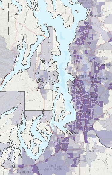
social, cultural and environmental challenges. The perspectives of the participants provide
a compelling illustration and validation of existing research. In some cases, where the
participants’ comments did not include information about specific climate risks, it raises
valuable questions about risk framing, communication and different sets of world views.

WHY NOW?

Equity is emerging as a guiding principle for climate preparedness planning and for actions
on environmental issues more generally (e.g., King County, 2015; Willimas-Rajee and Evans,
2016; City of Seattle, 2018a,b). Recently-proposed legislation for a carbon pollution tax in
the Washington Legislature included language to direct a portion of the revenue to support
communities of color, indigenous peoples and communities with lower incomes, to support
the transition away from fossil fuel use and to mitigate the harm from climate impacts (WA
Senate Bill 6203, 2018). Also, Initiative 1631, a proposed ballot Initiative for the November
2018 elections in Washington state, has similar language regarding the use of revenues
from a carbon pollution fee to benefit “vulnerable” populations facing health and socio-
economic barriers that are potentially exacerbated by climate impacts (WA Initiative 1631,
2018).

For climate policies and programs to effectively address existing or future inequities faced
by communities of color, indigenous peoples and communities with lower incomes in
Washington state, there needs to be credible information about who is at risk in Washington
state from climate impacts, and why. This information should clarify how communities may
be exposed differently and how factors like race/ethnicity, wealth, income, level of
education and health status affect the ability to cope with climate change-related impacts.
It should also highlight the types of community strengths, assets, and processes that can
be supported to build resilience to climate impacts.

By synthesizing current knowledge and identifying where further research might be
valuable, this report aims to support ongoing discussions regarding the climate risks
facing communities in Washington state, with a special emphasis on risks faced by
communities of color, indigenous peoples and communities with lower incomes.

                                                                                           5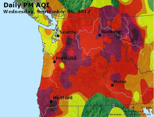
WHO IS THIS REPORT FOR?

There are four primary audiences for this report:

   1. Those involved in formulating and overseeing local and state programs that
      address greenhouse gas emissions and climate preparedness. The report is
      intended to point to resources that might provide more detailed information on
      specific topics and highlight areas of community and point to knowledge gaps that
      warrant future focus.

   2. Community-based organizations and environmental justice groups that are
      raising awareness about the climate concerns and issues facing communities
      of color, indigenous peoples and communities with lower incomes. The
      combination of first-hand experiences of participants in the Listening Sessions with
      existing research may be a useful tool for groups as they work with the general public
      or with specific state, tribal, or local agencies.

   3. Researchers in search of opportunities to build needed knowledge related to the
      distribution of climate risk across Washington state and beyond. The research needs
      that have been identified will likely require an interdisciplinary approach and may be
      of interest to diverse natural and social science research communities, as well as
      stakeholders in the community that are willing to lead, partner, and participate.

   4. Funders who financially support research and climate justice efforts across
      Washington state.

REPORT OVERVIEW

   > Chapter 2 outlines the approach used to develop this report, describes the community
   listening sessions and introduces the conceptual framework for climate risk used in this
   report.

   > Chapter 3 provides a brief introduction to the climate change-related hazards facing
   Washington state.

   > Chapters 4 and 5 both focus on climate risks: Climate Risks That Affect People Where
   They Live (Chapter 4) and Climate Risks That Affect People Based on Their Livelihood
   (Chapter 5). The choice to organize the risk information into these chapters was made

                                                                                          6
based on comments from the Listening Sessions, where issues related to “home” or
“work” were often the focus of discussion.
Each risk chapter has two main sections:
1. A section on risk Exposure describes how climate risks depend on the geography of
where people live (floodplains, wildland-urban interface, urban centers) and the
demographic characteristics of communities in these areas (Chapter 4), as well as the
sector in which they work (agriculture, fisheries, construction; Chapter 5).
2. A section on individual and community Vulnerability describes how a host of
socioeconomic factors, race/ethnicity, level of education, wealth and income, and
community infrastructure act to amplify or mitigate climate risks (Table 1).
TABLE 1: Selected areas and industries that are exposed to climate impacts and the
factors that affect vulnerability discussed in this report.
Exposure based on Where People Factors that Affect Vulnerability
Live (Chapter 4) (Chapters 4 & 5)
> Floodplains > Race and Ethnicity
> Wildland-Urban Interface > Wealth & Income
> Urban areas > Linguistic Isolation
> Social Cohesion
> Age and Health Status
Exposure based on Livelihood > Perception of Risk
(Chapter 5) > Community Infrastructure
> Agriculture > Cultural Value/Importance
> Fisheries > Education and Job Mobility
> Construction > Existing Environmental Stressors
> Immigration Status
> Water Rights
> Chapter 6, Community-Responsive Approaches to Building Climate Resilience, is solutions-
oriented and provides resources for preparing for future climate impacts and examples
of inclusive processes driven by community members. It discusses linkages between
policies and programs designed to manage climate risk and those aimed at reducing
greenhouse gas emissions.
7> Chapter 7 identifies several Research Gaps. Further research involving community
members in these areas could support progress in addressing the disproportionate
climate risks across Washington.
Excerpts or summaries from the Listening Sessions appear throughout the report. The
excerpts are used to emphasize the perspectives of the Listening Session participants,
and to frame the discussion of the literature around their statements. In some instances,
quotations are taken from other reports, rather than the Listening Sessions. Citations
are provided for these excerpts.
It is critical to emphasize that this report is intended as a starting point to catalyze further
discussion, engagement, and research. The material presented here is not an exhaustive
review of affected communities or the available literature. For example, the Listening
Sessions were conducted by organizations that were self-selected through a proposal
process. These sessions were intended to be geographically and demographically
diverse, but not a proportional sub-sample of communities across the state. In a similar
vein, the literature review largely reflects the authors’ collective expertise in regional
climate science and public health. Given the complexity of the issue, future work would
benefit from inclusion of a wider range of disciplinary backgrounds, with particular
emphasis on economics, demography, and social justice. In addition, this work presents
a snapshot in time (mid-2018). The experiences of individuals and communities are
constantly evolving, as is the research that draws from or illustrates these experiences.
8CHAPTER 2. REPORT APPROACH
WRITING TEAM
The writing team consisted of an interdisciplinary group of researchers from University of
Washington, including the Climate Impacts Group, Urban@UW and the Department of
Occupational and Environmental Health Sciences in the School of Public Health.
During the preparation of this report, input was solicited about the approach, content, and
format with the Front and Centered Steering Committee as well as an external group of
researchers from the University of Washington. Their feedback was invaluable for
improving this report; the research team is appreciative of their contributions and insights.
COMMUNITY LISTENING SESSIONS
Community listening sessions helped identify the ways that community members perceive
climate risks, providing critical input to the structure and content of this report. This section
provides a summary of the format for the sessions; greater detail can be found in Front and
Centered’s Listening Session Report (2017).
Listening sessions were conducted by various community-based organizations that work in
collaboration with Front and Centered. These organizations work in, and with, communities
who have been identified as disproportionately vulnerable to environmental harm,
including: communities of color, indigenous peoples, communities with lower incomes,
immigrants and refugees, and linguistically isolated groups.
To conduct the listening sessions, Front and Centered issued a request-for-proposals to
community-based organizations across the state to host listening sessions. Community-
based organizations that were selected received a facilitator's guide and accompanying
materials, including a note-taking template, a summary template for facilitators and a
request for photos following the listening sessions.
Community leaders from host organizations facilitated the listening sessions, took
individual notes and summarized each of their meetings. Where possible, Front and
Centered staff and affiliates attended the listening sessions. Food, beverages and childcare
were available when needed. When needed, an interpreter was also available for
translation. Eleven two-hour community listening sessions were hosted between July and
November 2017.
9FIGURE 1: Map of locations of community listening sessions across Washington state.
From: Front and Centered (2017).
Community organizations that helped to conduct these listening sessions include:
1. Asia Pacific Cultural Center (APCC) serves as an interactive cultural crossroads between
local and international communities in Tacoma, WA. The APCC hosted a listening
session in both English and Korean.
2. Chaplains on the Harbor, is a faith-based center providing the community with
resources and leadership development in Grays Harbor, Washington. Chaplains on
the Harbor hosted a listening session with particular emphasis on participation of
Quinault Tribal members.
3. Community to Community Development (C2C) is a women-led grassroots organization
dedicated to food sovereignty and immigrant rights. C2C hosted a Spanish listening
session in Bellingham, WA. Participants included Latinx young adults, parents, farm
workers, and students from the community.
4. Entre Hermanos promotes the health and wellbeing of the Latino gay, lesbian,
bisexual, transgender, and questioning community in a culturally appropriate
environment through disease prevention, education, support services, advocacy and
community building. Entre Hermanos hosted a listening session in both Spanish and
English in Seattle, WA.
5. Mother Africa assists African refugee and immigrant women and their children to
reach their highest potential. Mother Africa hosted a listening session in Kent, WA in
both Arabic and English with women from North Africa/Arabic cultural backgrounds.
106. The Snohomish County Branch (SCB) NAACP currently serves all communities between
South Snohomish County and the Canadian Border. They hosted a community
listening session that took place in Everett, with additional participants from
Edmonds and Lynnwood. Participants represented various backgrounds and
ethnicities.
7. The Latino Community Fund (LCF), Central Washington, cultivates new leaders, supports
cultural and community based non-profit organizations, and improves the quality of
life for all Washingtonians. LCF engaged Latinx youth in a listening session hosted in
both English and Spanish in Ellensburg, WA.
8. OneAmerica, Vancouver is Washington’s largest immigrant and refugee organizing,
advocacy and civic engagement organization. OneAmerica hosted a listening session
in Vancouver, WA in both English and Spanish. Community members, mainly Latinx,
participated in the meeting.
9. Na’ah Illahee Fund, Yakama Nation, and Olympic Peninsula supports and promotes the
leadership of indigenous women and girls in the ongoing regeneration of indigenous
communities. Na’ah Illahee Fund hosted two listening sessions as part of the tribal
community meetings: one within Yakama Nation, with tribal member representation
from the Snake and Columbia Rivers, with a focus on the Wanapum and another
listening session in Lower Elwha Klallam.
CONCEPTUAL FRAMEWORK FOR CLIMATE RISK
Following a global assessment of climate risk, this report defines risk as “the potential for
consequences when something of value is at stake and the outcome is uncertain…” (IPCC, 2014a).
Risk emerges at the intersection of hazards, exposure and vulnerability, where:
> Hazard is defined as a climate change-related event or trend that causes loss of life,
injury, or other health impacts, as well as damage to property, infrastructure, livelihoods
or ecosystems. This report focuses on events that occur in the current climate and are
expected to increase in frequency and/or magnitude as a consequence of climate
change (e.g. flood, wildfire, heatwaves).
> Exposure is the extent to which people, ecosystems, infrastructure or cultural
resources experience hazards. Exposure is often related to geography (e.g., people living
near the coast will be exposed to coastal flooding and sea-level rise, whereas those living
farther inland will not be exposed). However, other factors can influence exposure. For
example, individuals who work outside during heat waves or during smoke events
11typically face greater exposure to heat stress and poor air quality, relative to people who
can remain indoors.
> Vulnerability is the extent to which an individual or community will be adversely
affected when experiencing a climate-related hazard. Considerable research has
identified the various social, cultural and economic factors that contribute to
vulnerability (Cutter et al., 2003; Donner and Rodríguez, 2008; Balica et al., 2012). These
factors include wealth, race/ethnicity, health status, age and linguistic isolation. Since
most of the existing work on vulnerability to climate impacts is focused on broad scales
(e.g., national or international), or for specific communities and events (e.g., African-
American communities in the wake of Hurricane Katrina), this report attempts to identify
ways in which prior work is applicable to communities in Washington state.
FIGURE 2: Hazard-Exposure-Vulnerability conceptual framework used in this report for exploring
the community-based impacts of climate change-related hazards in Washington state. Modified
after IPCC (2014b).
The hazard-exposure-vulnerability conceptual framework is a useful lens for examining
potential policies or programs intended to boost climate preparedness. For example,
building flood protection structures would help reduce the impacts of flooding and lower
risks for communities near those structures. Policies or programs that would remove
incentives or add disincentives associated with settling in a floodplain minimize exposure,
12as fewer individuals would be in harm’s way. Efforts to reduce vulnerability might aim to
improve the housing stock of residents in the floodplain, or improve their access to
insurance, thereby allowing faster recovery following future flooding.
RACIAL AND ETHNIC DIVERSITY IN WASHINGTON STATE
Race and ethnicity play a central role in conversations about disproportionate climate risks.
To ground the discussion that follows in this report, it is useful to understand the
demographic characteristics of Washington communities, both now, and in the future.
Currently, a little more than 7 million people live in the state of Washington. Although the
current population is seventy percent white, the state’s racial/ethnic diversity is growing
and is projected to continue to grow in the coming decades. By 2050, it’s possible that over
half the state’s population will identify as Black, Latino, Asian Pacific Islander, Native
American, or Mixed race (Figure 3; classifications used are those defined by National Equity
Atlas, 2018). These trends are similar to those observed and expected for many other parts
of the country.
FIGURE 3: The proportion of
Washington’s non-white population
has grown substantially in the past
several decades and is projected to
continue to grow. By 2050,
projections show that half of
Washington’s population might be
people of color. From: National
Equity Atlas (2018).
13Across the state, several areas have relatively greater diversity: Central Washington,
including portions of Yakima, Benton, Kittitas, Grant, and Douglas counties; areas along the
Interstate-5 corridor, especially south of Seattle, near Tacoma and in Snohomish County;
and the areas near Willapa Bay and Grays Harbor (Figure 4).
While these maps can provide a useful snapshot of diversity across the state, caution should
be used when interpreting them. Summarizing population data by census-tract can obscure
the importance of densely populated areas where tracts are geographically small. Also, the
characteristics of minority groups with relatively small proportions of the population are
potentially lost in the spatial aggregation. For example, for tribal communities, which
represent a small proportion of the state population (~1%), these maps are unlikely to
capture areas that are culturally important. Additionally, the census categories for
race/ethnicity are coarse, and do not necessarily reflect the diverse needs, assets and
challenges that are present in different communities across the state.
FIGURE 4: ‘Social Vulnerability Index’ (SVI) maps likes these are used to indicate the relative
vulnerability of given area (drawn by U.S. census tracts) due to specific socioeconomic and
demographic variables. Here, darker shading (or a higher SVI) indicates greater proportions of non-
white residents and less English proficiency in Washington (left) and in Puget Sound (right). From:
CDC (2018).
14CHAPTER 3. CLIMATE CHANGE-RELATED HAZARDS
Weather and climate-related hazards, such as heat waves, droughts, wildfire and floods
pose challenges for all Washingtonians. In this section, we provide an overview of
Washington-specific climate-related hazards and explain how we expect human-caused
climate change to affect these hazards. For more in-depth discussion of climate change in
Washington state, please consult the State of Knowledge Reports for a) the Puget Sound
(Mauger et al., 2015), and b) Washington state (Snover et al., 2013). The technical
information presented in this section draws primarily from those synthesis documents.
Key points about hazards include:
> Climate-related hazards occur in the current climate. Future climate change is
anticipated to make many of these climate events more frequent or more intense.
> Past experiences with climate-related hazards provide an important guide for
understanding the ways in which communities are at risk, their ability to cope,
and the resources that can enhance the ability to cope under future climate
change.
> Climate-related hazards mean different things in different places. The
frequency, intensity, and consequences of different climate-related hazards will vary
for different communities in different locations. For example, a heat wave in Seattle
might have negative consequences when temperatures exceed 85°F, whereas the
same temperatures in parts of Eastern Washington are more common and might be
considered “normal.”
This report focuses on climate-related hazards specific to Washington state, with a focus on
the climate-related hazards that are expected to become more frequent or intense with
anthropogenic climate change. Although climate-related hazards in other parts of the
country and world will undoubtedly have important consequences for communities and
business in Washington (e.g., changes in global agriculture markets affect the prices and
export opportunities for food produced and consumed in Washington, thereby affecting
both consumers and agricultural workers), predicting the direction, timing, and magnitude
of these changes is beyond the scope of this report.
15WARMING TEMPERATURES
Washington state, and the Pacific Northwest more broadly, has warmed since the late
1800’s. Average annual temperatures in Washington have increased almost 1.8°F for the
period 1895-2017 (OWSC, 2018). The region has also experienced a number of notably
warm years in the recent decade—2015 was the warmest year on record (going back to
1895); 2016 was the fourth warmest; 2014 was the seventh warmest (NOAA, 2018).
Substantial warming is expected in the coming decades, which will make some of the recent
notably warm or record-setting years more like an average year in the future.
Warmer average temperatures raise the risk of extreme heat events, which threaten human
health. For example, by the 2020s the number of days that exceed a health heat alert
threshold in King County is projected to more than double, from about four days per year
to over nine days per year. By the mid-21st century, the number of days is projected to more
than triple, to about thirteen days per year (Isaksen et al., 2014)
Warmer air temperature also translates into
warmer water temperature. As air
temperatures warm, water temperatures
increase in streams, lakes, the Puget Sound
and the Pacific Ocean. Warmer temp-
eratures threaten fish, make it more likely for
harmful algae to bloom and create
conditions conducive for diseases that affect
shellfish. Recent closures of fisheries in 2015,
both in Washington and along the entire
West Coast, were largely driven by warm
temperatures (NOAA, 2016).
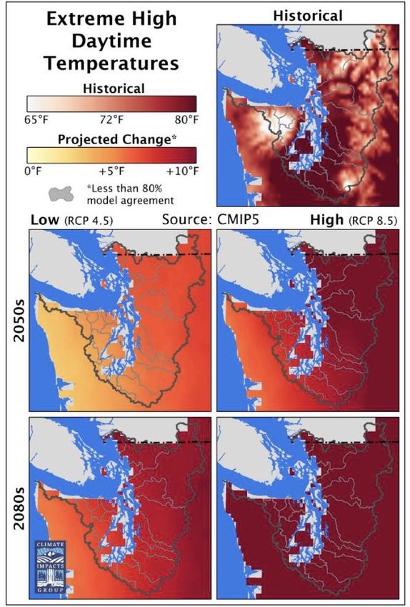
FIGURE 5: High temperatures on our hottest
days in the Puget Sound could be as much as
10°F warmer by the end of the 21st century
(compared to the historical period 1970-1999)
From: Mauger et al., 2015.
16While not always a hazard, warming air temperatures alter conditions important for
agriculture. On average, growing seasons (as measured by the absence of frost) have
lengthened in the Pacific Northwest by over 30 days and will continue to lengthen with
future warming. Longer growing seasons can help some crops; however, warming may
pose challenges for crops that rely on cold temperatures as part of their development
process.
It should be noted that warming reduces the frequency and intensity of cold conditions in
the winter. However, recent work on cities around the world suggests that health benefits
of milder winters are likely to be outweighed by the negative impacts from more intense
summer heat (Kinney et al., 2015; Staddon et al., 2014).
WATER STRESS AND DROUGHT
In the coming decades, the typical spring snowpack in Washington state is expected to be
less than in the past, as warming pushes snowlines to higher elevations. The region will be
left with less snowmelt in the summer, and many rivers will experience more frequent low
flow events, and potentially lower low flows (Figure 6; projected streamflow for major Puget
Sound watersheds is available in Mauger et al. (2015) Appendix D and for eastern
Washington in Hamlet et al. (2013). Combined with warmer summer temperatures that
drive up water demand, the stage is set for more frequent and severe droughts for areas
that rely on snowmelt. Reductions in streamflow also exacerbate warming of streams,
making it more difficult for cold-water fish, such as salmon, to thrive.
FIGURE 6: Projections of future
water supply for the Wenatchee
River show an anticipated
increase in natural winter water
supply and a decrease in natural
summer supply. While this is not
the case for all Washington
watersheds, many watersheds
will be facing changes in the
timing and amount of water
supply and demand. Modified
from: Washington Department
of Ecology (WA ECY, 2016a).
17In 2015, Washington state experienced low snowpack conditions arising from warmer-than-
average temperatures, which led to significant water stress for irrigators, managers of small
water systems, fisheries, and forests. These conditions are analogous to what is expected
in the future as a result of climate change. Specifically, the temperatures experienced
during the winter of 2015 are similar to the average conditions projected for the middle of
the 21st century. In many locations, the snow in 2015 resembled the average conditions
projected to occur at the end of the 21st century.
FLOODING
Flooding is influenced by many weather and climate factors, including the intensity of
rainfall (e.g., the amount of rain falling in periods of a few hours or a day), antecedent
rainfall that saturates soils and enhances runoff (e.g., the amount of rainfall that would fall
over a number of weeks or months), or the temperature at which precipitation falls (e.g., in
colder storms, more precipitation will fall as snow reducing the immediate flood risk by
retaining water in the snowpack rather than contributing to streamflow). There are also
many non-climatic factors that contribute to flooding, such as the presence of impervious
surfaces or stormwater infrastructure.
While it remains a challenge to project how future flooding may change at local scales, we
have relatively high confidence of how future climate change will increase flood risk through
changes in heavy precipitation, snowpack, and sea level.
> Heavy rainfall is anticipated to get heavier. The heaviest rainfall events on the West
Coast of the United States are delivered by ‘atmospheric rivers’ (also known as
‘pineapple express’ events), which are expected to produce more rain in the future. One
study suggests that these extreme precipitation events would yield 15-39% more
precipitation (based on a 24-hour period) by the end of the 21stcentury (relative to 1970-
1999; Warner et al., 2015).
> With higher snowlines, storms can generate higher streamflow. With warmer
temperatures, a greater portion of precipitation will fall as rain instead of snow,
increasing streamflow and raising flood risks along rivers and streams.
> Sea-level rise increases risk of coastal flooding. As sea level rises along the coasts,
including in Puget Sound, future coastal river floods, and local coastal saltwater flooding,
will be more severe, both in terms of water depth and the geographic area of flooding.
18These three factors (increasingly heavy rainfall, higher streamflow because of warmer
temperatures and sea-level rise) create the so-called “triple whammy” of flooding facing
many western Washington watersheds. In parts of eastern Washington where snowmelt
has typically been an important component of streamflow, the anticipated loss of snowpack
would raise flood risks in the fall and early winter and cause snowmelt-related flooding to
occur earlier in the spring. In areas where the geology sets the stage for landslides,
projected increases in heavy rainfall and the shift from winter snow to rain can also raise
landslide risk.
WILDFIRE
In recent years, and especially in 2014 and 2015 (and to a lesser extent 2017), Washington
experienced active wildfire seasons that caused significant damage and disruption across
the state. The fires led to numerous evacuations. Smoke spread across large areas of the
state, sometimes originating from fires burning outside of Washington state, leading to
unhealthy air quality conditions.
Although forest management practices, historical fire suppression, and development into
fire-prone areas (the ‘wildland-urban interface’) have all contributed to fire risk, human-
caused warming has increased wildfires across the Western United States (Abatzoglou and
Williams, 2016). As warming continues, we expect wildfire potential to increase, as warmer
temperatures and drier conditions dry out live and dead vegetation that is the fuel for
wildfires. Many future climate projections indicate less rain falling in the summer across
Washington. Although summers are already relatively dry, this future drying exacerbates
fire risk.
Although eastern Washington is more accustomed to wildfire, western Washington is also
susceptible to wildfires and has experienced large wildfires in the past. It is projected that
future fires in western Washington could burn more area, due to increased drying of these
dense forests. Given the proximity to most of the state’s population, the consequences of
a large fire in western Washington could be significant.
AIR QUALITY
Use of fossil fuels, which is the key driver of global climate change, also contributes to poor
air quality. Fossil fuel combustion creates pollution that leads to smog and ground-level
ozone, which can have adverse health impacts. In addition, fossil fuel combustion generates
small particulate matter that can cause respiratory problems. Reducing use of fossil fuels
brings about the co-benefit of reducing these air pollutants.
19Warmer summers may also contribute to decreased air quality, especially in urban areas
where air pollution is relatively high. Warmer conditions facilitate the formation of ground-
level ozone (Jackson et al., 2010). Although progress to improve air quality has been made
in many areas of Washington State, future warming could work against these
accomplishments.
OCEAN ACIDIFICATION
Strong evidence has emerged that the acidity of the near-shore ocean and the Puget Sound
are increasing as a result of higher carbon dioxide concentrations in the atmosphere (Feely
et al., 2012). Greater acidity harms zooplankton, with potentially significant consequences
for the marine food web and can inhibit shellfish from forming their calcium shells, affecting
important fisheries in the state. Researchers across the state, in universities and federal
agencies, are working to better understand the specific consequences for Washington state
(e.g. Washington Marine Resources Advisory Council, 2017).
CHANGES IN THE SPREAD OF INFECTIOUS DISEASE
Across continents and around the world, climate change is affecting and will continue to
alter the spread of diseases (USGCRP, 2016). Climate change can affect the ‘vectors,’ like
mosquitoes, that spread disease (e.g. West Nile virus); it can permit new pathogens to thrive
in new places (e.g. Cryptococcus gattii, a tropical and subtropical fungus recently found in
British Columbia); and it can affect the presence of food-borne diseases (e.g. vibrio bacterial
outbreaks in shellfish). Understanding how these disease pathways will change in
Washington is an active area of research and public health monitoring.
20CHAPTER 4. RISK BASED ON PLACE OF RESIDENCE
Where people live is one of the most important determinants of their exposure to climate
change-related hazards. In this section, we focus on several geographic areas in
Washington that are exposed to climate change-related impacts including floodplains, the
wildland-urban interface, and urban areas. Then, we discuss the socioeconomic and
cultural factors that contribute to vulnerability, both within, and beyond, these exposed
areas.
[Climate change] really affects our morale and our
feelings, how we interact and communicate with each
other. We are off-balanced. Are we resting like we
should be resting? It is hard to live together with all
the climate change. It is affecting us mentally and
spiritually.
- Lower Elwha Listening Session, 2017
EXPOSURE
Exposure in Floodplains
A floodplain refers to areas near coasts or rivers that experience periodic flooding. More
technical definitions (e.g. FEMA, 2018) tend to focus on areas that have a 1% chance of
experiencing flooding in any given year, i.e., areas that would be exposed to the “100-year
flood.” Large portions of Western Washington are considered to be within a floodplain.
As discussed in the previous chapter, flood risks are expected to increase in the future,
owing to heavier rainfall events, more winter precipitation falling as rain instead of snow,
and sea level rise (for coastal areas). Consequently, many existing floodplains are likely to
become more risky places to live in the future, and larger areas are likely to be susceptible
to flooding. These changes in flood risk are expected to be most apparent in Western
Washington (e.g. Hamlet et al., 2013).
21FIGURE 7: A relatively large proportion of the population in western Washington lives in floodplains.
The greatest exposure is in Skagit, Grays Harbor, and Lewis Counties. From: Washington
Department of Ecology, RiskMAP Business Plan (WA ECY, 2016b).
Floods pose direct threats to individuals and their property. Flooding can also impair water
quality, introducing contaminants into water supplies. Disruption to transportation
networks during floods can prevent people from getting to work or accessing critical health
services. Following floods, damaged homes can experience mold, which poses health risks
to residents.
An important knowledge gap exists in identifying the characteristics (e.g., race/ethnicity,
wealth, age, type of housing) of individuals and communities that live in the current
floodplain, as well as those likely to live in floodplains in the future. Studies have suggested
that a disproportionately high percentage of the population residing in floodplains across
the nation is composed of racial and ethnic minorities (Donner and Rodríguez, 2008). This
is also reflected in analyses of specific, local flooding events along the U.S. Gulf Coast (e.g.,
Adeola, 2003). However, such an analysis has not been conducted for Washington state.
There are specific watersheds where Native American populations are highly exposed to
flood risks (See ‘Tribes and Flood Risks’ text box), and certain areas where relatively large
floodplains and sizeable racial and ethnic enclaves intersect, including the Yakima Valley
and portions of the I-5 corridor south of Seattle.
22TRIBES AND FLOOD RISKS
Many tribal communities in western Washington, including the Swinomish Indian Tribal
Community (2010), the Jamestown S’Klallam Tribe (2013), and the Port Gamble S’Klallam
Tribe (2017), have identified flooding and sea level rise as important issues in their climate
change vulnerability assessments and adaptation plans. Some of these communities’ lands
are highly exposed to flooding. At the Hoh Indian Reservation, 90 percent of the reservation
land is in a 100-year floodplain (Papiez, 2009). For the Swinomish Tribe, 15 percent of land
is at risk from sea level rise, including the community’s economic zone at the north end of
Fidalgo Island (Snover et al., 2013).
The Quinault Indian Nation is taking steps to relocate the village of Taholah to higher
elevation, following damaging floods in 2014 and 2015 (Quinault Indian Nation Business
Committee, 2017; US Climate Resilience Toolkit, 2017). These events demonstrated the
village’s vulnerability to catastrophic flood damage from future tsunamis, or from sea level
rise. While relocation may be an extreme option for most communities, the experience of
the Quinault provides insight into how a coastal tribe is planning for future flood risks.
Exposure in the Wildland-Urban Interface
The “wildland-urban interface” is the area of transition between developed lands and less-
developed natural areas. In areas around the I-5 corridor, the interface may be relatively
sharp as one moves eastward toward the Cascade Mountains; in other parts of the state,
like Kittitas County, any of the unincorporated parts of the county are considered to be part
of the interface (Kittitas County Community Development Services, 2018).
Wildfire is of high concern in these areas, as the presence of people and structures
introduce wildfire-related risks to human health, homes, businesses and transportation
systems. Similar to the floodplains, there is no census information that identifies precisely
who lives in the wildland-urban interface. However, there has been substantial population
growth in these areas. Between 1990 and 2010, over 300,000 homes were added to the
wildland-urban interface in Washington state, an increase of over 50% (Martinuzzi et al.,
2015). Census tract data demonstrates some of the wealth disparities that exist between
different portions of the wildland-urban interface in Washington. Many of the regions on
the eastern slopes of the Cascade Mountains are relatively poor; nearly all the tracts fall in
bottom half of the poverty index (Figure 8). Some of the areas around the Olympic National
Park and Olympic National Forest also exhibit relatively high rates of poverty. It is the
opposite case for the western slopes of the Cascades.
23FIGURE 8: Relative rankings for the percentage of people in poverty. Except for Wenatchee,
Spokane, and the Tri-Cities, most of the census tracts in eastern Washington, including those areas
in the wildland-urban interface, are in the bottom half of the state’s poverty rankings. From:
Washington Tracking Network, 2018.
While the direct exposure to fire itself may be limited primarily to those living at the
wildland-urban interface, the health threats from wildfire smoke can spread much further.
For example, most of the state was faced with smoke impacts during large wildfire events
in the summer of 2017 (Figure 9). Of particular note, the August 2017 fires were taking place
in British Columbia, demonstrating how wildfire threats beyond the state’s borders can still
affect people in Washington. The smoke posed challenges for those with pre-existing
respiratory problems (e.g., asthma, chronic obstructive pulmonary disease (COPD),
children, and the elderly; WA DOH, 2017; see Vulnerability, Age and Health Status section).
FIGURE 9: Air Quality index maps for Aug. 3, 2017 and Sept. 6, 2017. Both days show the large
geographic range of poor air quality (black, purple, red) resulting from wildfire smoke. For the
August case, the fires were in British Columbia; in September, the fires were primarily in eastern
Washington. Red and purple shades correspond to hazardous air quality conditions, even for
normally healthy individuals. Yellow corresponds to moderate air quality; green corresponds to
good air quality. From: AirNow (2018).
24Exposure in Urban Areas
Large land areas in urban environments covered with concrete and asphalt amplify the
intensity of increased air temperatures (known as the urban heat island; e.g., Kenward et
al, 2015; EPA, 2018). The large amount of paved surfaces, combined with the relatively
smaller amount of vegetation, elevates daytime high temperatures and nighttime low
temperatures and can increase the duration of heat events.
Paved, impervious surfaces also prevent rainfall from absorbing into soil, increasing
stormwater runoff during heavy rain events, creating the conditions for flooding. Heavy rain
and flooding can cause damage to water treatment systems or lead to contamination of
water bodies (e.g., following combined-sewer overflows).
Had a house flood due to stormwater. [I was]
displaced for 9 months.
- NAACP Listening Session
Due to the density of vehicles and industry, urban areas (and areas downwind of urban
centers) can experience issues with air quality, especially during warm summer days. Future
warming may increase the chances of poor air quality by enhancing the formation of
ground-level ozone, which can cause respiratory issues.
The large population of Washington’s urban areas make them a priority for considering
climate risk. Nearly 10% of the state’s population lives in Seattle (704,352, as of 2016); and
the combined metropolitan area of Seattle-Tacoma-Olympia includes almost two-thirds of
the state’s population (U.S. Census Bureau, 2016). In addition to the urban corridor along
the Puget Sound, Spokane is the state’s second largest city (215,973, as of 2016), and
Vancouver, Yakima, and the Tri-Cities (Kennewick, Pasco and Richland, collectively) have
populations exceeding 80,000.
Cities also include a relatively large proportion of people of color in Washington state. The
population of Central Puget Sound, including seven of the state’s ten largest cities (Seattle,
Tacoma, Bellevue, Kent, Everett, Renton, and Federal Way), is approximately 65% white, 13%
Asian Pacific Islander, 10% Hispanic, 5% Black, 1% Native American and 6% Mixed Race.
Several cities in the region, including Bellevue, Kent, Renton, and Federal Way are majority
non-white. Outside of the Puget Sound, the city of Yakima has a large proportion of people
of color—just under 50% of the population is Hispanic.
25It is important to note that exposure to climate change-related hazards is not uniform
within a city. For example, some areas of cities have significant tree canopy, which can offset
the urban heat island effect. However, in many cities, including Seattle, census tracts with
high proportions of people of color or low-income individuals tend to have less tree canopy
(City of Seattle, 2016a), creating a racial/ethnic and socioeconomic disparity in exposure to
high temperatures that can be ameliorated by shade. Additionally, access to affordable
housing, poor housing quality or homelessness can significantly contribute to an
individual’s exposure to climate change-related hazards.
FACTORS AFFECTING VULNERABILITY
There are a range of socioeconomic factors that contribute to the vulnerability of individuals
and communities to climate impacts. The following sections describe these factors and
discuss how they intersect with the demographics of Washington state in general, as well
as the demographics of locations within the state that are highly exposed to climate-related
hazards. The list of vulnerability factors below is not comprehensive, but introduces
concepts found in the literature (e.g. Cutter, 2003, Cutter et al., 2009; Tierney 2006), as well
as those mentioned in the Listening Sessions.
Vulnerability is a multifaceted phenomenon. As
such, solutions, too, must be multifaceted, addressing
the range of social, cultural, demographic and economic
conditions – often interacting in complex ways – that
culminate in population vulnerability…Individual
preparedness and response to disasters is generally
influenced by factors that have little to do with the
hazard agent or the disaster event itself, such as social
class, education, gender, race/ethnicity, cultural
background and language proficiency, among others.
- Donner and Rodriguez, 2008
26You can also read