Analysis of the Possibility of Using Unmanned
←
→
Page content transcription
If your browser does not render page correctly, please read the page content below
Analysis of the Possibility of Using Unmanned
                                      Aerial Vehicles and Thermovision
                                       for the Stocktaking of Big Game
doi:10.2478/mape-2021-0029
Date of submission to the Editor: 06/2021        MAPE 2021, volume 4, issue 1, pp. 317-329
Date of acceptance by the Editor: 08/2021

Arkadiusz Boczkowski
ORCID ID: 0000-0002-5042-5862
Silesian University of Technology, Poland

Artur Kuboszek
ORCID ID: 0000-0002-8499-8028
Silesian University of Technology, Poland

Adam Mańka
ORCID ID: 0000-0002-0003-939X
Silesian University of Technology, Poland

Karolina Dutkiewicz
Silesian University of Technology, Poland

Wiktoria Gramatyka
Silesian University of Technology, Poland

Aleksandra Leśniak
Silesian University of Technology, Poland

Magdalena Spyrka
Silesian University of Technology, Poland

Ewa Stawinoga
Silesian University of Technology, Poland

INTRODUCTION
The hunting economy carried out in the hunting district generally consists in
breeding wild game that lives in the free state. Breeding activities mainly consist
in maintaining the appropriate abundance of animals depending on the capacity
of the hunting ground, influencing the proper physical individual development
and population development of the game, maintaining the quantitative status of
game endangered with extinction, implementing activities related to
reintroduction, or establishing a strategy to fighting infectious diseases, for
example ASF. The breeding of animals is carried out based on hunting plans
which are prepared with informations about the numbers of animals of a
particular species. Therefore, all activities related to the management of
populations are based on the stocktaking of animals in the hunting district. It is
crucial for the correct planning of future breeding activities. The stocktaking
includes the following species of big game: moose, deer, fallow deer, roe deer,
wild boar, mouflon as well as small game: fox, raccoon dog, badger, marten,
hare and pheasant. The stocktaking is performed on March 10 each year, which
allows to estimate the condition of the game before the breeding season begins

 Contact address: arkadiusz.boczkowski@polsl.pl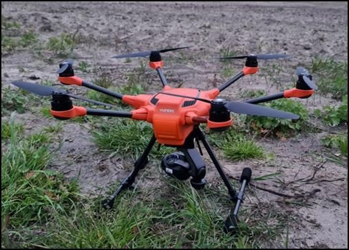
318 Multidisciplinary Aspects of Production Engineering – MAPE vol. 4, issue 1, 2021
and to plan breeding activities taking into account the planned increase in the
number of individual species. The hunting breeding year runs from April 1 to
March 31 each year. The rest of this article will concern methods of estimating
the size of big game.
As a result of the stocktaking, we usually obtain an estimated number of animals.
Due to the size of the areas inhabited by wild animals, the type of areas (forests,
fields), their location and availability, it is impossible to carry out this activity in a
precise manner. It is necessary to apply some simplifications resulting from
terrain capabilities, technical capabilities, human resources, weather conditions,
etc. Therefore, there are many methods of estimating the number of animals.
Their principles, advantages and disadvantages will be discussed in the next
chapter.
REVIEW OF CLASSIC METHODS OF STOCKTAKING BIG GAME
Due to the method of observation a stocktaking of the game can be divided into
direct and indirect. Direct methods are based on direct visual contact with the
game, while indirect methods allow to determine the number of game based on
the signs of its existence, e.g. following tracks. The best-known direct methods
include: test drive, belt assessments of hares and partridges, aerial counting,
counting on feeding grounds and feeding places, spring counting of roe deer in
fields and meadows and year-round observations. In turn, indirect methods
include: tracking branches, tracking on transects, determining the areas of
tagged individuals, counting roaring bulls, counting voices of tooting pheasant
and partridges, DNA determination from faeces, counting deer pellets,
registration of beaver lodges, counting badger colonies, etc. (Okarma et al.,
2008).
In practice, the most frequently used methods of stocktaking large game are:
test drive method, tracking on transects, counting on feeding grounds and
feeding places, and the method of year-round observation.
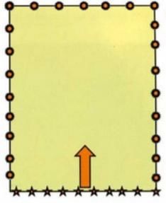
Test drive method
This method consists in counting the driven game in a specific area of the
investigated forest or field, called a litter. This area is surrounded by stationary
and mobile observers, as shown in Fig. 1.
Fig. 1 Scheme of placing the participants during the direct counting
of animals on the sample plot
Source: (Okarma et al., 2008)
Engineering and Technology                                                        319

Mobile observers pass through the litter, driving the game outside the study
area. Only individuals leaving the litter are counted. The area to be driven is
determined randomly or systematically. It should constitute at least 10% of the
entire surveyed area.
The advantage of this method is relatively high accuracy and the ability to
determine the age and sex of driven game. The larger the forcing area, the more
precise the results are. The disadvantage, however, is that to conduct it, you
need a very large number of observers with appropriate knowledge about the
recognition of the game (age or sex). It is therefore cost-intensive and difficult to
organize. Due to the random selection of areas, there is a risk of encountering
a cluster population or omitting this group of animals due to their temporary
migration, which has a negative impact on the credibility of the results (Zalewski
et al., 2018).

Tracking on transects method
It consists in counting game tracks on permanent transects. The number of
tracks allows to determine the number of animals in the hunting district. This
method is best used in winter as the tracks are clearly visible in fresh snow. It
does not require engaging such large forces and resources as in the case of test
drive method. An additional advantage of the method is the possibility of
studying the changes in the population size of species that occur in small
numbers. It is possible to collect information about the abundance, distribution
and mobility of the game in the winter, as well as its behavior and reactions to
certain environmental factors. However, it depends on the season and weather
conditions, because local snow melting causes gaps in observations, and its
absence or continuous precipitation prevents it completely (Okarma et al.,
2008).

Spring counting of roe deers in fields and meadows method
Spring counting of roe deer is performed in early spring, when the first vegetation
after winter appears and the animals go out into the fields. Observations are
made in the evening or in the morning, from fixed positions or while on the move.
Roe deer are territorial animals, therefore this method is used in small and
medium-sized forest complexes (up to 1 kilometer wide). Thanks to the tests
carried out in the open space, the animals are clearly visible to the observers. It
is worth noting that this method carries a high probability of mistake, because it
is not certain whether all animals have left the forest. There is also the possibility
of accidentally scaring the animals off (Okarma et al., 2008).

Counting on feeding grounds and feeding places method
Counting at feeders and feeding grounds is a very similar method to the one
described above. It allows you to count large species of animals, where
individual herds are identified based on their abundance or size of individuals.
Counting takes place on frequently visited feeders or farmlands. Mistakes in the
320        Multidisciplinary Aspects of Production Engineering – MAPE vol. 4, issue 1, 2021

results may appear due to difficulties in counting single individuals or finding
herds of the same size. This method works well especially in winter for counting
fallow deer and deer, when bulls and doe with calves stay in separate swarms
(Okarma et al., 2008).

Year-round observation method
The year-round observation method is mainly a complementary method to other,
which is used to study the number of animals. It is based on recording the
species, sex and the amount that is encountered during the year. After recording
the results, an analysis is performed at the end of the inventory period that
presents the results of the observations (Okarma et al., 2008).

THE USE OF THERMOVISION FOR THE ANIMAL IDENTIFICATION AND
ESTIMATION OF THE POPULATION SIZE
The direct methods of animal inventory, described above, are based on counting
individuals with which we are in direct eye contact. During some observations
binoculars are used, but they do not guarantee to see animals obscured by
branches or grass. This way a lot of animals can be missed in observations. The
quality and effectiveness of observations can be significantly increased by using
the technology of observation of thermal (infrared) radiation, which can provide
us with an image of the temperature distribution of studied objects and its
surroundings. Accessibility of this technology is common nowadays and the
prices of thermal cameras range between one and several thousand zlotys.
However, not all thermal cameras are suitable for these applications. An
important feature of thermal imaging cameras is the resolution of the bolometric
transducer, the size of the lens and the optical approximation. Cameras
designed for typical night observations, e.g. Pulsar Thermion XP50 (telescope),
Helion 2 XP50 Pro (monocular), or Accolade 2 XP50 LRF Pro (binoculars) have
sensors with a resolution of 640x480 pixels with a pixel size of 17 µm, which
with a 50 mm F lens/1.2 and 2x optical magnification gives the possibility of
detection from a distance of 1800m. The 50 Hz image refresh rate ensures
smooth images in motion. The weight of such cameras ranges from 600 to 700
grams. There are also slightly smaller and cheaper observation cameras
available on the market, e.g. Hikvision Lynx LH15, LH19 and LH25, with
transducers with lower resolutions, e.g. 384x284 pixels with a pixel size of 12
µm, optical magnification 1.5x, 1.7x to 2,5x respectively, and 15, 19 and 25mm
lenses, making it possible to recognize a human-sized object from a distance of
375, 475 and 625 m, respectively. Their weight is slightly smaller and amounts
to about 300 grams. HIKVision cameras are also available with larger lenses
and higher transducer resolutions. The smallest and cheapest thermal imaging
cameras are cameras that can be connected to a mobile phone via USB, e.g.
Seek Thermal Compact Pro with a resolution of 320x240 pixels, refresh rate of
9 Hz and a detection range of 500 m. The manufacturer does not specify the
lens diameter, the base magnification is 1x.
Engineering and Technology                                                            321

The described thermal imaging cameras were subjected to field tests involving
the observation of the game at a known distance and subjective assessment of
the image quality and the possibility of correct recognition of the game species.
As part of the work of PBL, four types of thermal imaging cameras were tested,
namely: Pulsar Thermion XP50, Pulsar Accolade 2 XP50 LRF Pro, HKVision
Lynx LH15 and Seek Thermal Compact Pro. During the tests, the animals were
observed from different distances, and then the clarity of the images was
compared and the optimal distances at which the animal can be easily
recognized were determined.
As a result of the tests, it was found that all compact cameras do not meet the
expectations and they cannot be used to recognize the game at a distance
bigger than 10-20 m. The reason here is mainly the small diameter of the lens
and the poor optics of the camera.
Figure 2 shows a comparison of images obtained from thermal imaging cameras
the Pulsar Thermion XP50 and Seek Thermal Compact Pro. In the foreground
you can see 2 hares at a distance of 60 m from the observer, while at a distance
of 200 m there are 3 roe deer. The first of the cameras has x2 optical
magnification, while the second one has x1. In Figure 3, on the other hand, there
are pictures of 2 hares in the field at a distance of 150 m from the observer.

 Fig. 2 The photo of 2 hares at a distance of 60 m and 3 roe deer at a distance of 200 m,
      taken with cameras: a) Pulsar Thermion XP50, b) Seek Thermal Compact Pro

Fig. 3 The photo of 2 hares at a distance of 150 m, taken with thermal imaging cameras:
                a) Pulsar Thermion XP50, b) Seek Thermal Compact Pro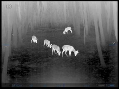
322         Multidisciplinary Aspects of Production Engineering – MAPE vol. 4, issue 1, 2021

Cameras having slightly better transducers and a larger diameter provide more
clear image of objects observed from a longer distance. For the purposes of
correct and unequivocal identification of larger animals, it seems, however, that
the limit observation distance should not exceed 200 m (maximum 300 m). Of
course, recognition of the game at longer distance is also possible, but it is
based on an additional analysis of the behaviour and the way the animals move.
Figure 4 shows images from thermal imaging cameras recorded at different
distances. Figure 4a) shows 2 roe deer at a distance of 500 m, seen in the Pulsar
Thermion XP50 camera (50 mm lens), while in Figure 4b) we have roe deer at
a distance of 300m, observed with HKVision Lynx H15 (15 mm lens). The first
photo is quite clear, but the distance of 500 m seems too big to clearly recognise
the game.

 Fig. 4 The photo of roe deer taken with thermal imaging cameras: a) Pulsar Thermion
      XP50 – at a distance of 500 m, b) HKVision Lynx H15 – at a distance of 300 m

In the case of distances less than 200 m, the recognition of the game is much
more reliable and unambiguous. Therefore, the use of such observation
distances in combination with the use of cameras with bolometric transducers
640x480 pixels and lens with a diameter of 50 mm will allow to obtain images of
appropriate quality, which would be analysed, for example, using artificial
intelligence methods. Fig. 5 shows examples of images of large and small game
recorded with the Pulsar Thermion XP50 and Pulsar Accolade XP50 cameras
(devices comparable with each other in terms of parameters).
To sum up the conducted field tests of thermal imaging cameras, it can be
unequivocally stated that the best effects for the recognition of the big game are
obtained at the border distance of up to 200 m. Of course, at longer distances
the recognition of the game is also possible, but the image becomes less clear
and it is much easier to make a mistake. If you want to use the features of
thermal imaging cameras in combination with flights over forest or field areas
with the use of unmanned aerial vehicles (drones), you should take into
consideration one more limitation resulting from the regulations of the Civil
Aviation Authority, which is the limitation of VLOS flights in the open category to
the limit height of 120 m. For the purposes of game inventory, this limitation is
not an obstacle, as this distance ensures obtaining clear images from thermal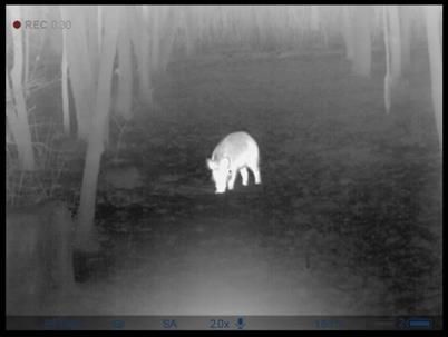
Engineering and Technology                                                         323

imaging cameras. Determining one animal observation distance will significantly
facilitate its recognition also thanks to assessing its size. It is possible if the
camera is installed on the drone and the flight is made at a constant height. In
the next stage, it is necessary to determine the optimal flight height due to the
area covered by the scanning in one flight (it depends on the angle of the camera
lens, optical magnification and the flight altitude), as well as the possible scaring
of the game due to the noise emitted by the drone.

 Fig. 5 Photos taken with Pulsar Thermion and Accolade cameras: a) fox at a distance
     of 50m, b) wild boar at a distance of 25m, c) roe deer at a distance of 40-60 m,
                      d) a swarm of deer at a distance of 120-200 m

To sum up the conducted field tests of thermal imaging cameras, it can be
unequivocally stated that the best effects for the recognition of the big game are
obtained at the border distance of up to 200 m. Of course, at longer distances
the recognition of the game is also possible, but the image becomes less clear
and it is much easier to make a mistake. If you want to use the features of
thermal imaging cameras in combination with flights over forest or field areas
with the use of unmanned aerial vehicles (drones), you should take into
consideration one more limitation resulting from the regulations of the Civil
Aviation Authority, which is the limitation of VLOS flights in the open category to
the limit height of 120 m.
For the purposes of game inventory, this limitation is not an obstacle, as this
distance ensures obtaining clear images from thermal imaging cameras.
Determining one animal observation distance will significantly facilitate its
recognition also thanks to assessing its size. It is possible if the camera is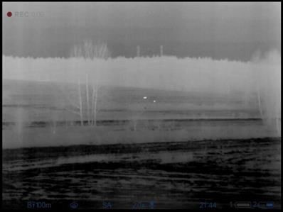
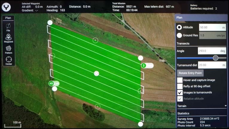
324         Multidisciplinary Aspects of Production Engineering – MAPE vol. 4, issue 1, 2021

installed on the drone and the flight is made at a constant height. In the next
stage, it is necessary to determine the optimal flight height due to the area
covered by the scanning in one flight ( it depends on the angle of the camera
lens, optical magnification and the flight altitude), as well as the possible scaring
of the game due to the noise emitted by the drone.

POSSIBILITY OF USING UNMANNED AERIAL VEHICLES FOR GAME
INVENTORY
The use of unmanned aerial vehicles for game inventory in theory seems to be
relatively simple, due to the existing mechanisms that allow for autonomous
flights according to the developed scenarios. They are used, for example, in the
implementation of aerial photos and orthophotomaps. Then it is possible to
declare the area covered by scanning, flight routes, frequency of taking photos
(depending on the height), etc. These mechanisms can be used directly to plan
and execute flights, and to create high-resolution geocoded graphic files, which
then need to be analysed by recognizing species and counting the number of
individual animals. From the technical point of view, there are no major problems
with the implementation of such a task. Figure 6 shows the Yuneec H520 drone
prepared for flight, equipped with the E90 camera and the developed flight
scenario.

   Fig. 6 Drone Yuneec H520 prepared for flight (a) with developed flight scenario (b)
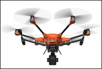
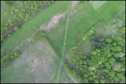
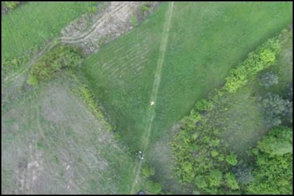
Engineering and Technology                                                     325

The flight covers an area of over 20 ha, the flight height is 50 m, which gives the
image resolution of 1.5 cm/px. During the flight, 224 photos will be taken. The
marked lines indicate flight routes, and their density depends on the declared
flight altitude, the degree of image coverage and the type of camera installed.
The fundamental problems in the implementation of flights with the use of
unmanned aerial vehicles do not result from the technical capabilities of the task,
but from the proper planning and organization of a flight adapted to the goal we
want to achieve. Proper planning and selection of flight parameters must take
into account:
• the type of game we want to inventory,
• type of area where we intend to carry out the inventory,
• determining the correct altitude of the flights,
• the time of year in which we conduct the inventory,
• other specific restrictions.
The elements mentioned above are closely related. The first and fundamental
issue that should be taken into account is, of course, the type of game that we
intend to inventory. In general, we can talk about a general division into big game
( elk, deer, fallow deer, mouflon, wild boar and roe deer) and small game ( foxes,
badgers, hares). Usually, however, we want a more detailed inventory of big
game, so we will focus on it later in the article. Each type of game has a slightly
different biotype, so it will occur in a different area, which may depend on the
type of habitat, season, month, day and weather conditions. Knowledge of the
behaviour of animals in a given area is a very important factor that guarantees
the correctness and accuracy of the inventory. As a rule, the inventory is carried
out at the end of winter, determining the condition of the game on March 10 of
a given year. Then the grasses in the meadows are laid and there are no leaves
on the trees and shrubs, thanks to which the forests are sufficiently transparent.
In such a period, the use of a thermal imaging camera will give the best results,
because you can easily take inventory into both field and forest areas.
Another element is determining the altitude of flights. On the one hand, the flight
should be carried out low enough to be able to correctly identify the game. On
the other hand, increasing the flight altitude gives a much larger area of
observation. The selection of these parameters obviously depends on the type
and resolution of the camera used, the angle of view, the diameter of the lens,
magnification, etc. Therefore, it is impossible to provide specific data here,
although some guidelines can certainly be drawn. As part of the field research
conducted as part of the PBL project, flight tests were carried out with the
Yuneec H520 drone equipped with the E90 camera operating in 4K resolution
at 60 FPS. These tests were aimed at determining the actual area of the terrain
covered by the identification at different flight altitudes and at analysing the
possibilities of recognizing the game. Figure 7 shows photos taken at different
heights of the drone. The control cross has a size of 1.25x1.25 m, photos were
taken in 4K resolution.
326         Multidisciplinary Aspects of Production Engineering – MAPE vol. 4, issue 1, 2021

      Fig. 7 Photos taken with Yuneec H520 drone with E90 camera from a height:
                           a) 10 m, b) 30 m, c) 60 m, d) 100 m

Analysing the above photos, it was found that the best results for the
identification of the game with acceptable land cover are obtained at a height of
approximately 60 m for large game and about 30 m for small game in the size
of a hare or fox. At a height of 60 m the 0.58 ha area covered was obtained
(rectangle 95 m x 62 m), while at 30 m the coverage was 0.15 ha (rectangle 47
m x 31 m). Another important aspect is the fact that the game is scared off by
the noise caused by the drone's flight. The test was carried out on roe deer and
hares. Roe deer in open terrain shied at flight altitudes up to 40 m, while above
50 m they did not pay attention to the flight. In the forest area, the flight at a
height of 40 m (20 m above the trees) did not cause the escape of the game.
The hares, on the other hand, turned out to be exceptionally little skittish game
and even a flight at a height of 20 m did not scare them away. Here, however, it
should be clearly emphasized that depending on the weight and construction of
the drone, as well as weather conditions, they will emit different levels of noise,
and determining the optimal height of flights will always be the most difficult task.
Each scare of the game during the inventory will result in the need to repeat it
on the next day.
Due to the intensive foraging of the game, it is the best to carry out the inventory
at night. Then, the game leaves its daily refuges and stays in the open area
looking for food. Most often these are cultivated fields sown with winter crops,
covered with grasses and weeds, meadows and wastelands. Hence, the use of
unmanned aerial vehicles equipped with an appropriate thermal imaging camera
seems to be the best solution, allowing for a relatively easy location,
identification and counting the animals. In the months of February and March,
Engineering and Technology 327
when inventories of big game are most often carried out, forest areas are also
transparent enough to make an inventory in them.
The last element of a technical nature is the selection of an appropriate thermal
imaging camera. At the moment, for example, for H520 drones, 2 types of
thermal imaging cameras are produced, namely the cheapest CGOET with a
bolometric transducer resolution of 160x120 pixels, frequency 9 Hz, field of view
of 56 degrees and sensitivity < 50 mK, and the most expensive E10TVX camera
with a maximum bolometric resolution of 640x512 pixels., frequency 9 Hz, field
of view 32 degrees, sensitivity < 50 mK and pixel size 12 µm. For the purpose
of the game inventory, the use of the first of these cameras should be excluded
due to the insufficient resolution of the bolometer, as the image obtained from a
distance of 60 m will be too imprecise. In the case of the second camera, the
resolution of the bolometer is sufficient, but the refresh rate is too low. The field
experiments show that the proper sharpness of the figure of a moving animal
can be obtained in the case of a camera with an image refresh rate of approx.
50 Hz. The pixel size, thermal sensitivity of the camera and the viewing angle
are acceptable in this case. The smaller the angle of view of the camera, the
more accurate the image will be, but the smaller area of the terrain will be
scanned at the same height of the flight. Apart from the camera parameters
themselves, an important role is also played by the software adaptation to the
intended purpose of work, the selection of an appropriate color palette,
determination of the temperature sensitivity range and image scale, etc.
However, the analysis of these parameters should be carried out on the basis
of a specific camera model. The Yuneec H520 drone equipped with the E10TVX
thermal imaging camera is shown in Fig. 8.
Fig. 8 Yuneec H520 drone equipped with E10TVX thermal imaging camera
Source: photo www.yuneec.pl)
SUMMARY
The use of unmanned aerial vehicles for game inventory is an area of interest
for many major research centers in Poland (Witczuk et al., 2018), (Witczuk et
al., 2021) and around the world (Gonzalez et al., 2016). These studies mainly
concern the accuracy of methods using thermal imaging, the possibility of
recognizing animals with the use of artificial intelligence methods, etc. The328 Multidisciplinary Aspects of Production Engineering – MAPE vol. 4, issue 1, 2021
above subject is becoming more and more popular due to the emerging
technical possibilities of replacing the classic methods of inventory, which are
known to be inaccurate, very expensive and difficult in organisation. The
increasing availability of more accurate thermal imaging cameras and
technologically advanced drones with a much greater payload and flight time,
gives the possibility of their more and more common use for the implementation
of game inventory activities. The use of unmanned aerial vehicles (drones)
equipped with a thermal imaging camera makes it possible to carry out an
inventory practically by 2 people in a very short time. There is no need to engage
dozens of observers and traverse the often inaccessible terrain. Research
conducted in research centers also shows its high accuracy. Then, the field tests
described in this article, carried out as part of the PBL work, proved that this
technology can be used by such entities as hunting clubs or forest divisions to
carry out annual inventory of animals. This article discusses the issue of game
inventory with the use of drones equipped with a thermal imaging camera from
the technical and organizational side. A number of trials and field tests were
carried out with the use of available thermal imaging cameras. Preparatory
works are currently underway for the implementation of flights in accordance
with the guidelines provided, which will be possible to implement in the period
from November to March. The obtained results will constitute material for further
research.
REFERENCES
Kossak, S. (2001). Zintegrowana metoda szacowania stanów liczebnych struktury
populacji ssaków łownych i chronionych w Puszczy Białowieskiej. Instytut
Badawczy Leśnictwa. Białowieża.
Okarma, H. and Tomek, A. (2008). Łowiectwo. Wydawnictwo Edukacyjno-Naukowe
H2O. Kraków.
Witczuk, J. and Pagacz, S. (2021). Evaluating alternative flights plants in thermal drone
wildlife surveys – simulation study. Museum and Institute of Zoology Polish
Academy of Sciences. International Journal of Remote Sensing 13.
Witczuk, J., Pagacz, S., Zmarz, A. and Cypel, M. (2018). Exploring the feasibility of
unmanned aerial vehicles and thermal imaging for ungulate surveys in forest –
preliminary results. International Journal of Remote Sensing 39.
Zalewski, D., Okarma, H. and Panek, M. (2018). Monitoring liczebności i jakości
populacji dzikich zwierząt. Uniwersytet Warmińsko-Mazurski w Olsztynie.
Olsztyn.
Gonzalez, L., Montes, G., Puig, E., Johnson, E., Mengersen, K. and Gatson, K. (2016).
Unmanned aerial vehicles and artificial intelligence revolutionizing wildlife
monitoring and conservation. Sensors, 16, 97.Engineering and Technology 329 Abstract: Classic methods of stocktaking big game living in a given area have many disadvantages. The main result is the need to ensure appropriate terrain and weather conditions and also require the involvement of a large number of people, so-called observers. The development of technology makes it possible to create new stocktaking methods that will not have as many of the above-mentioned disadvantages, while reducing the cost of stocktaking and increasing its accuracy. This paper presents an analysis of the possibility of using unmanned aerial vehicles, so-called drones, in combination with the observation of game in the infrared wave range with the use of a thermal imaging camera. The paper presents the concept of such a solution, which will of course be further developed. Raids are planned with the use of thermal cameras over areas according to strictly defined transects and subjecting the obtained images to analysis, also with the use of artificial intelligence methods. This article was written as part of the PBL project carried out by a group of students from the Silesian University of Technology under the supervision of dr inż. Arkadiusz Boczkowski. Keywords: stocktaking of big game, wild animals, thermal imaging camera, dron
You can also read