Appendix L Resilience - Colorado Department of Transportation
←
→
Page content transcription
If your browser does not render page correctly, please read the page content below
Appendix L
        Resilience

     Resilience
     “The ability of communities to rebound, positively adapt to, or thrive amidst changing
     conditions or challenges—including human-caused and natural disasters—and to maintain
     quality of life, healthy growth, durable systems, economic vitality, and conservation of
     resources for present and future generations.” — Colorado House Bill 18-1394
     “The ability to prepare and plan for, absorb, recover from, or more successfully adapt to
     actual or potential adverse events.” — American Association of State Highway and
     Transportation Officials (AASHTO)

     Statewide Transportation Plan
Colorado Department of Transportation                                                 August 16, 2021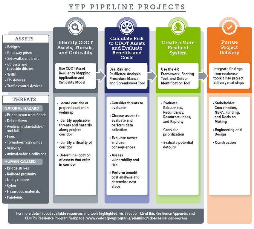
Table of Contents

Table of Contents .......................................................................................................
Section 1 What is Resiliency and Why Does It Matter? .................................. 1-1
     1.1         Resilience Planning and CDOT’s Resilience Program................................... 1-1
     1.2         Resilience Planning Benefits ............................................................... 1-2
     1.3         Why Resilience Matters to CDOT’s Statewide Plan ..................................... 1-2
     1.4         Resilience Planning Participants for Colorado’s Transportation Network .......... 1-3
     1.5         Available Resources Regarding Resilience Planning .................................... 1-4
     1.6         References .................................................................................... 1-5
Section 2 Resiliency Within the Transportation Planning Process ............ 2-1
     2.1      Integration Recommendations ............................................................. 2-1
         2.1.1    Consult with Agencies/Organizations ............................................... 2-1
         2.1.2    Evaluate System Level Vulnerability ................................................ 2-2
         2.1.3    Use Identified Risks to Inform Transportation Decisions ......................... 2-3
         2.1.4    Assess Interdisciplinary Resilience ................................................... 2-3
     2.2      Assessment of Resiliency Planning: Your Transportation Plan ....................... 2-6
Section 3 Resilience Evaluation ......................................................................... 3-1
     3.1         CDOT Resilience Webmap and Statewide Risk and Criticality Summary ............ 3-1
     3.2         Project Development Resiliency Toolkit ............................................... 3-15

List of Figures
  Figure 3.1 Pipeline Project Development Resiliency Toolkit Workflow .......................... 3-16

List of Tables
  No table of figures entries found.List of Tables
  Table 1.1: Resilience Resources and Tools ............................................................. 1-4
  Table 2.1: 4R Framework for Identifying and Evaluating Resiliency in Transportation System
  Assets and Organizations .................................................................................. 2-4
  Table 3-1: Statewide Risk Summary and Criticality for Pipeline Projects ......................... 3-2

Statewide Transportation Plan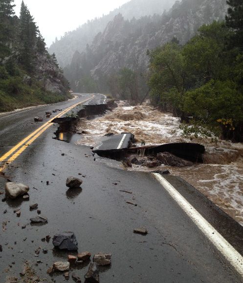
Section 1
What is Resiliency and Why Does It
Matter?
1.1 Resilience Planning and Response to the COVID-19
CDOT’s Resilience Program Pandemic
Given the increasing prevalence of extreme weather events and The 2020-2021 worldwide
risks associated with human activities, planning for resiliency is pandemic – COVID-19 – forced
gaining increasing recognition as an important consideration in agencies to think about resiliency
infrastructure development and operations. in a new way. While the long-term
implications of COVID-19 are still
The Federal Highway Administration (FHWA), transportation unknown, we do know that CDOT
agencies, and communities are facing extreme weather events was able to respond quickly to
that damage roads, bridges, and transportation infrastructure. transitioning employees to working
These events come with high repair costs and economic impacts from home due to the lessons
from disrupted travel. learned and tactics implemented
in response to the 2018
According to the Colorado Resiliency Office, resiliency planning cyberattack. Moving forward,
involves links between the environment and social and economic CDOT must consider public health
sectors to improve communities holistically and to foster emergencies as a potential threat
adaptability to changing conditions. Preparing the that could impact the agency from
transportation network is especially important as these routes an organizational, administrative,
provide access to homes, businesses, schools, and hospitals. and operational perspective. As
During a disaster event, emergency personnel and communities COVID-19 restrictions begin to lift,
rely on the transportation network for response and CDOT will need to assess lessons
evacuations. learned and integrate public
health into its resiliency planning.
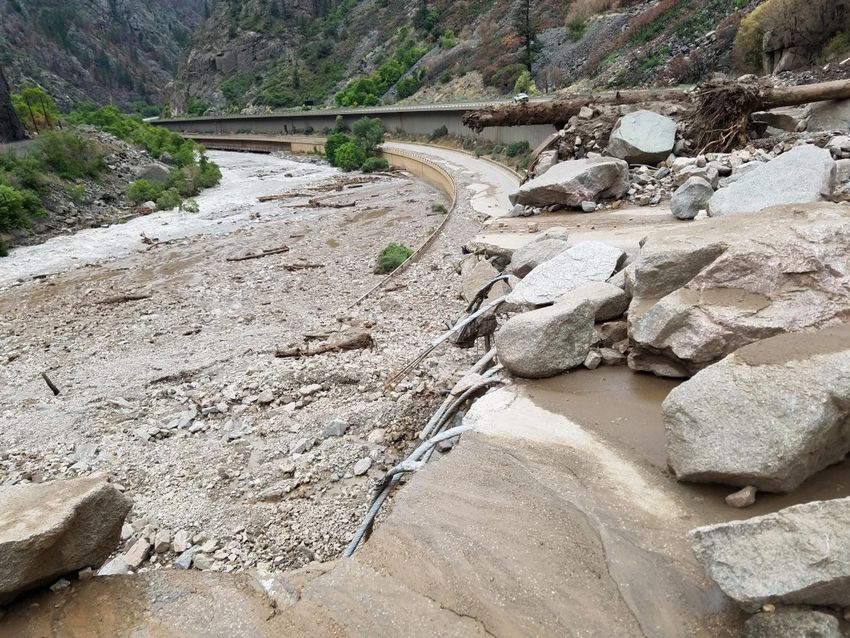
Resiliency became a priority for CDOT after the 2013 Front
Range flooding event caused severe damage to the roadway
network, impacting roughly 500 miles of roads and 50 bridges, and requiring more than
$700 million in emergency repairs. CDOT, businesses, and the traveling public all felt the
financial impact and inconvenience. Recognizing the importance of transportation resiliency,
Colorado Department of Transportation (CDOT) adopted Policy Directive 1905.0 in 2018 for
“Building Resilience into Transportation Infrastructure and Operations.”
CDOT has been investing in resilience since 2015 and is emphasizing resilience throughout its
organization and for the State’s transportation system. Building resilience is like an insurance
policy. By identifying a threat and implementing a mitigation measure, CDOT is working to
reduce risks to the transportation system. Proactive management of threats before they occur
minimizes the resources needed to rebuild and restore service, minimizes disruptions to
people’s lives and to business activity, and lowers the cost to CDOT and the traveling public in
the long run. An additional overview of CDOT’s resilience program is included on the CDOT
website.
Statewide Transportation Plan 1-1
Appendix L Resilience
1.2 Resilience Planning These lists are not exhaustive but
Benefits present examples of threats faced
by CDOT and the traveling public.
The benefits of resilience are widespread, including fiscal
Natural Hazard Threats
benefits by saving the state money; social and economic
benefits, by saving the public time and ensuring timely Bridge scour from floods:
access to markets for business; and safety benefits, by erosion of soil supporting
taking action before a disruption becomes disastrous. bridge structure and causing
structural damage
Building on lessons learned from the 2013 floods and other Debris flows: moving mass of
natural disaster events and disruptions, CDOT is assessing loose mud, sand, soil, rock,
risks from threats to better prepare the transportation and water down a slope
system in advance. Every day the system faces natural Avalanches/landslides/
hazard threats, large and small. CDOT is planning for these rockfalls: moving mass of
adverse events to ensure our system is resilient, meaning it snow, earth, or rock from a
is better able to withstand the impact of events and mountain or cliff
recover quickly when they happen. Resilience Fires: wildfires or range fires
considerations are proactive (i.e., occurring before an burning along or near a
event), compared with emergency response activities (i.e., corridor
rescuing, recovering, and rebuilding). Tornadoes/high winds:
strong gusts/storms causing
1.3 Why Resilience Matters to infrastructure damage
Visibility: intense fog or
CDOT’s Statewide Plan ground level cloud cover
CDOT is targeting resilient system improvements to provide along corridor
the greatest return on investment. In other words, Animal-vehicle collisions:
proactively allocating funds to address infrastructure and accidents between wildlife
operational needs now avoids a more significant recovery and vehicles
cost in the future. Human Caused Threats
According to the National Institute of Building Sciences Bridge strikes: truck collision
causing structural damage
(2019):
Railroad proximity: train
Every $1 spent improving utilities, roads, derailment or stall that
highways, and railroads saves $4 in repairs. affects highway operations
Utility rupture: explosion or
Nationally, the past 23 years of federally funded
sink hole affecting highway
natural hazard mitigation ultimately will prevent
operations
600 deaths, 1 million nonfatal injuries, and
4,000 incidents of post-traumatic stress disorder
Cyber: attack on CDOT’s
system or intelligent
CDOT’s efforts in resiliency are also aimed at complying transportation
with federal requirements and associated regulations of the Hazardous materials: spill of
Fixing America’s Surface Transportation (FAST) Act. hazardous materials or waste
Through this act, resiliency considerations are necessary for affecting highway operations
risk-based asset management plans and as a “planning Pandemic: prevalent disease
factor” in the transportation planning process for spread affecting staff
departments of transportation (DOTs) and metropolitan resources and availability,
planning organizations (MPOs). which affects highway
operations
Statewide Transportation Plan 1-2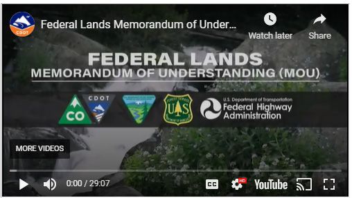
Appendix L Resilience
1.4 Resilience Planning
Participants for Glenwood Canyon
Colorado’s
Transportation
Network
In 2015, CDOT established the Resiliency Working
Group. The group meets monthly and includes a
statewide effort across specialties/disciplines.
CDOT also has an Executive Oversight Committee
(EOC) that meets every other month as a
decision-making body. The Working Group was set up to
help CDOT advance the resilience program into all aspects
of CDOT’s work. In addition, the following stakeholders
are involved:
Other CDOT planners, engineers, scientists,
decision-makers, and officials
Colorado Resiliency Office (CRO), housed in the
State’s Department of Local Affairs
FHWA and Federal Transit Administration (FTA)
officials and decision-makers
Regional transportation planning and MPO staff
and decision-makers SH 72 and Coal Bank Creek
Transit agency officials and decision-makers
Local Agency staff, administrators, and
elected officials
Federal land management agencies
Federal Emergency Management
Agency (FEMA) and local offices of
emergency management
Stormwater management agencies
Emergency responders
High Park Fire
Fire prevention districts
State and university climatologists
Community members, including business owners, health care facility managers, and
school managers
Transportation consultants/specialists
Statewide Transportation Plan 1-3Appendix L Resilience
1.5 Available Resources Regarding Resilience
Planning
Further information is available at the state and federal levels and from national organizations.
Table 1.1 provides an overview of this information.
Table 1.1: Resilience Resources and Tools
Reference and Hyperlink Resilience Focus
State of Colorado Sources
CDOT’s Resilience Program Includes background information, CDOT’s Resilience Policy
website Directive, CDOT’s Risk and Resiliency Manual, I-70 Risk and
Resilience Pilot Study, and Resiliency Planning Resources.
CDOT Risk and Resilience Identifies procedures for calculating risks to CDOT's system from
Analysis Procedure Manual natural hazards. Provides a standard method for calculating risk
(2020) associated with different threats and the benefit/cost of investing in
resiliency measures.
CDOT Risk and Resilience Accompanies the procedure manual as an Excel tool to help
Analysis Procedure automate calculations. Could be helpful during project delivery,
Spreadsheet Tool including NEPA; asset management; and project prioritization.
CDOT Risk and Resilience Describes CDOT’s model for asset criticality.
Analysis Procedure Criticality
Model for System Resilience
CDOT Risk and Resiliency Aids in assessment and documentation of a project in terms of
Project Scoring Tool robustness, redundancy, resourcefulness, and rapidity; project
prioritization; and risk mitigation.
CDOT 4R Framework for Provides guidance on how to integrate resiliency considerations in
Identifying and Evaluating transportation. The four Rs of resiliency include:
Resiliency in Transportation Robustness: the strength of an asset or a system to withstand
System Assets and relevant threats
Organizations
Redundancy: the presence of a backup system or plan
Resourcefulness: the ability to identify, diagnose, and treat
problems with available resources
Rapidity: the ability to restore functionality in a timely way
CDOT Detour Identification Informs evaluation and selection of detours. Developed with the
Tool statewide travel demand management team to offer detour
suggestions. At this time, the tool does not reroute real time based
on congestion.
CDOT Asset Resiliency Supports standardization for calculating risk and resiliency on the
Interactive Mapping state's transportation system. Includes hazards or threats, route
Application criticality, and pipeline projects from the Statewide Plan.
CDOT Resilience Case Studies Under development. Will be added to CDOT’s Resilience Program
website as a “proof of concept.”
Asset Management – Twice Damaged Assets
M & O – Flood Mitigation Plans for Minor Culverts
Planning and Project Prioritization
Environmental Documents
Project Scoping and Engineering
Colorado Resiliency Office Includes general resources regarding resiliency and information to
website support planning, take action, and recovery.
Statewide Transportation Plan 1-4Appendix L Resilience
Reference and Hyperlink Resilience Focus
CDOT’s Federal Lands Addresses interagency coordination needs among CDOT, FHWA,
Memorandum of United States Forest Service (USFS), and Bureau of Land
Understanding (MOU) (2016) Management (BLM). Addresses imminent hazards, snow avalanche
hazard mitigation, and authorization for entry during emergency
situations.
Federal Sources
BLM Forest Resilience and Identifies risks/potential hazards and goals for resource
Ecosystem Services website management to achieve resilience.
Federal Highway Includes policy and guidance, case studies, research, and other
Administration Resilience resources for transportation officials and communities.
website
Federal Transit Details a presentation on disaster resilience and transit asset
Administration presentation management.
Federal Emergency Provides information about federal insurance and mitigation
Management Agency website administration, national preparedness, national continuity programs,
and grant programs.
USFS Transportation Provides a process to assess and address climate change impacts on
Resiliency Guidebook: USFS transportation assets at the local and regional levels.
Addressing Climate Change
Impacts on USFS
Transportation Assets
National Organization Sources
AASHTO Infrastructure Includes information about programs, policies, case studies,
Resilience website resources, and tools related to surface transportation infrastructure
resilience to extreme weather and changing climate conditions.
APA Planning for Defines the threat posed by more frequent and severe flooding to
Infrastructure Resilience public infrastructure and outlines the role of planners and plans in
Report 596 (2019) ensuring that infrastructure is prepared for an unpredictable future.
National Institute of Building Addresses mitigation measures that can result in significant savings
Sciences Natural Hazard in terms of safety and preventing property loss and societal
Mitigation Saves Report disruptions.
(2019)
Other State DOT Information
Florida DOT Resilience Quick Provides information about incorporating resilience into long range
Guide: Incorporating transportation plans.
Resilience in the MPO Long
Range Transportation Plan
(2020)
1.6 References
2018. CDOT. Policy Directive 1905.0: Building Resilience into Transportation Infrastructure and
Operations. https://www.codot.gov/programs/planning/documents/plans-projects-
reports/projects/resilience_program/policy-directive-pd-1905.0
2019. National Institute of Building Sciences. Natural Hazard Mitigation Saves Report.
https://cdn.ymaws.com/www.nibs.org/resource/resmgr/reports/mitigation_saves_2019/mitiga
tionsaves2019report.pdf.
Statewide Transportation Plan 1-5Section 2
Resiliency Within the Transportation
Planning Process
2.1 Integration Recommendations
CDOT and other transportation planning agencies are working to collect data about known
threats to Colorado’s transportation system. Since 2015, CDOT has been working to use this data
to inform investment decisions and day-to-day business operations with the goal of hardening
the system against threats before they happen. CDOT is also developing resilience tools and
figuring out how to apply those tools to inform decisions that integrate resilience
considerations.
The benefits of resilience are widespread, including:
Fiscal benefits by saving the state money
Social and economic benefits by saving the public time and ensuring timely access to
markets for business
Safety benefits by acting before a disruption becomes disastrous
It is sensible to manage CDOT’s transportation system in a way that reduces exposure to threats
and to make investment decisions that improve system resiliency. Proactively managing
potential threats before they occur minimizes the resources needed to rebuild and restore
service, lessens the disruptions to people’s lives and to business activity, and lowers the cost to
CDOT and the traveling public in the long run.
The FAST Act requires transportation agencies to consider resilience during transportation
planning processes (23 Code of Federal Regulations [CFR] 450.200 and 23 CFR 450.300). To
implement the requirement, the final planning rule added “improving resiliency and reliability
of the transportation system” as one of the 10 transportation planning factors that DOTs and
MPOs must address. The final metropolitan and statewide planning rule also added a
requirement for MPOs to coordinate with officials responsible for natural disaster risk reduction
when developing a metropolitan transportation plan and Transportation Improvement Program.
It also added a requirement to assess capital investment and other strategies that reduce
vulnerability of existing transportation infrastructure to natural disasters
(Section 450.324(f)(7)). The following steps are recommended to advance resiliency integration
in CDOT’s statewide transportation planning process.
2.1.1 Consult with Agencies/Organizations
As part of the planning process, CDOT should consult with agencies and organizations
responsible for natural disaster risk reduction and document that collaboration in the body of
the plan. Such organizations are outlined in Section 1.4. For future statewide transportation
planning efforts, this consultation could mimic the environmental consultation approach used in
the 2045 Statewide Transportation Plan. Data from CDOT’s Asset Resiliency Interactive Mapping
Statewide Transportation Plan 2-1Appendix L Resilience
Application, which includes priority transportation projects (e.g., the 10-year project pipeline),
should be shared with agencies and organizations, allowing them to comment on the projects
and identify opportunities to enhance resilience associated with specific projects.
2.1.2 Evaluate System Level Vulnerability
FHWA suggests that transportation planning agencies conduct a system level vulnerability
assessment of their transportation assets to identify which portions of their system are most at
risk to damage from threats. At the systemwide planning scale, a vulnerability assessment may
be more of a high level, broad brush look at where the system is at potential risk to various
threats and where damage is likely to be greatest. The assessment may cover a variety of
threats or could be limited to one or two threats most likely to occur within the study area.
CDOT’s research has shown that flooding, rockfall, and fire/debris flow tend to be the most
impactful events in Colorado.
FHWA advises agencies to consider three factors when identifying asset vulnerability:
Whether the assets are located within areas exposed to the selected threat(s)
How likely the asset is to be damaged/compromised if the threat occurs
The adaptive capacity of the system to recover; in other words, how quickly or easily
the system can recover from an event and how severely it compromises system
operations
For the first factor in identifying vulnerability, CDOT maintains the Asset Resiliency Interactive
Mapping Application, which includes hazards or threats, route criticality, and pipeline projects
from the Statewide Plan. More information is included in Section 3.1. Anecdotal or historical
information about where flooding, rockfall, or other events have tended to occur may also be
used.
For the second factor, information on the age or condition of the asset may be used and
augmented by other indicators of how an asset will perform under stress (e.g., bridge scour
rating).
For the third factor, adaptive capacity, the agency can identify which portions of the
transportation system are most critical to the continued operation of the system. This may be
done via a rating system or model using various criteria (volume of traffic, availability of
alternate routes, or social and economic characteristics of the areas being served by the
identified portion of the transportation system).
CDOT has developed a criticality map for all routes within the state highway system. The model
used six criteria:
Annual average daily traffic Redundancy (presence of alternate routes)
Roadway classification Value of freight carried
Social vulnerability index Value of tourism in the vicinity
The system level vulnerability evaluation, including criticality mapping, should be updated
regularly, particularly in advance of the statewide transportation planning process. CDOT has a
criticality model for System Resilience. Criticality reflects the importance of each
transportation asset relative to overall operations in CDOT’s transportation network. Criticality
Statewide Transportation Plan 2-2Appendix L Resilience
considers overall resilience of the system and success of CDOT to carry out its mission of
delivering service to its travelers. It is not a measure of cost or a qualifier of how an asset would
respond to a threat. CDOT has criticality data statewide that were modeled along development
of the 2017 I-70 Risk and Resilience Pilot Study. More information about CDOT’s assessment of
asset criticality is available in this document. At the time this appendix was developed, CDOT
anticipates having additional criticality mapping resources and information available on the
Resilience Program webpage in the future.
2.1.3 Use Identified Risks to Inform Transportation Decisions
The plan should articulate a process for how to use information on identified risks in
transportation decision-making. Ideally risk and resiliency will be incorporated into all aspects
of the project lifecycle, including planning, asset management and project prioritization,
project development and environmental review, project level design, system management and
operations, and emergency management. The goal should be to build both technical resiliency
by hardening or improving the physical system assets and organizational resiliency to improve
CDOT’s ability to make decisions and take actions to plan and respond to events. The following
sections define how resiliency could be integrated into various aspects of the project lifecycle.
1. Project Prioritization: Project screening and evaluation, which is the process used to
prioritize projects and inform investment decisions, should consider resiliency as an
evaluation criterion. For example, is the project located on a “critical” route? Would
the project improve system resiliency?
2. Project Development and Environmental Review: Priority projects (e.g., those
included in the 10-year project pipeline) that are in hazard areas should be evaluated
using the toolkit in Section 3.2 to identify design or operation strategies to reduce
identified vulnerability.
3. Project Design: As a project advances into preliminary and final design, the design
team should further consider the 4R Framework (Table 2.1), following evaluation
using the toolkit. This framework encourages coordination and decision-making to
inform project delivery in terms of enhancing project resiliency and reducing project
vulnerability. More information is included in Section 3.2.
4. Asset Management: CDOT's Asset Management Program develops and implements
risk-based strategies to ensure the Department's limited funding is applied to the right
project, for the right asset, at the right time. The 4R Framework also helps inform
decisions for asset management.
2.1.4 Assess Interdisciplinary Resilience
The CRO has several reference documents and tools related to advancing resiliency in all sectors
of the State, emphasizing an interdisciplinary approach to resiliency. The Colorado Resiliency
Framework Plan identifies core sectors critical to advancing resiliency in Colorado communities:
Infrastructure Housing
Economy Watersheds
Community Natural Resources
Health and Social
Statewide Transportation Plan 2-3Appendix L Resilience
Table 2.1: 4R Framework for Identifying and Evaluating Resiliency in Transportation System
Assets and Organizations
A Resilient A Resilient
Technical Organizational
Attribute Description Transportation Transportation
Examples Examples
Asset Organization
Robustness The strength of Made of Building to a Has an Systemwide
an asset or a materials, higher design organizational vulnerability
system to structures, standard in an mind-set of assessment and
withstand elements, area prone to enthusiasm for resiliency
relevant threats systems etc. Is historic challenges, problem investment plan.
maintained in flooding (e.g., solving, agility, Maintenance
proper 50-year vs flexibility, patrol plan in
condition, 20-year storm; innovation and place to clean
allowing it to upsizing taking opportunity. out at-risk
withstand a culverts). Has identified culverts more
given level of Installing green vulnerabilities and frequently than
stress or demand infrastructure has processes in normal.
without (e.g., place to use
suffering information on Feedback loop
vegetative from emergency
degradation or swales) in vulnerability to aid
loss of function. in decision-making. events with
areas prone to advice on how to
Is safe to fail -- flooding. Has systems in
designed, where place to recognize improve asset
relevant, to Installing nets and reward high strength
allow controlled, on high-risk performance.
planned failure rock sheds.
during
unpredicted
conditions,
recognizing that
the possibility of
failure can never
be eliminated.
Redundancy The presence of Has parts, Construction of Promotes open Backup computer
a backup system elements, an alternate communication and servers.
or plan systems, detour route mitigation of Development of a
facilities, etc. where none internal/external statewide detour
that are exists. silos. Understands map and
substitutable, Backup traffic interconnectedness evaluation of
e.g., are capable operations and vulnerabilities gaps in system
of satisfying center. across all aspects of redundancy.
backup agency function.
functional Transit route/ Cross-trained
requirements in Express lanes staff.
the event of on a highly Supplemental
disruption, congested “snow patrol”
degradation, or freeway. staff identified
loss of Bridge built and on-call to
functionality of with redundant assist in storm
the primary methods of event.
system. avoiding
Redundancy may failure.
involve excess
capacity (e.g.,
frontage lanes,
breakdown
lanes, managed
capacity), or
diverse means of
capacity (e.g.,
detour routes,
different
modes).
Statewide Transportation Plan 2-4Appendix L Resilience
A Resilient A Resilient
Technical Organizational
Attribute Description Transportation Transportation
Examples Examples
Asset Organization
Resourcefulness Ability to Includes Stockpiling Has ability to IGAs with other
identify, equipment to emergency efficiently mobilize agencies in place
diagnose, and monitor and repair/storm sufficient number in advance to
treat problems alert to treatment of trained staff to borrow needed
with available potential threats materials to monitor warning materials in
resources or failures handle systems, with emergency
before they unplanned authorization to situations.
occur. Sufficient events. initiate action. Has IT staff on-call
materials are on Optimizing established with skills and
hand to positioning of relationships, abilities needed
efficiently snow plows prearranged mutual to respond to a
mobilize in case and materials. aid arrangements cyber-attack.
of emergency. Real-time and regulatory
partnerships. After-action
stream gauges reviews with
as a warning Learns from the
success or failure of feedback to
system in high change where
risk areas. previous efforts.
needed.
Rapidity Ability to Designed in such Placing VMS Has established Documented
restore a way that it is signs in response plans in structure and
functionality in quick to restore vulnerable place to mobilize roles for
a timely way functionality, areas to when events occur. emergency
containing losses redirect users. Has systems and response – who’s
and avoiding Purchasing a manuals in charge, what
disruptions. temporary documented and in skills does each
Communications bridge for use place for how to need to have,
equipment and as needed in manage emergency etc.
networks are in emergency events. Learns from On call contracts
place and washouts. the success or in place ahead of
function at high failure of previous emergencies to
performance. efforts to improve mobilize needed
response time. contractor
assistance.
Establish and
monitor
performance
measures for
emergency
response time.
Traffic Incident
Management Plan
adopted.
Conducting
emergency
response drills.
The CRO Resiliency Playbook is a guide for Colorado agencies interested in building
multidisciplinary resiliency into their organizations, investments, and internal policies. The
Playbook includes a “Resiliency Prioritization Assessment Tool,” which provides a method for
scoring a plan, project, or program on a wide variety of resilience indicators. CDOT could use
this tool to assess resiliency planning associated with each iteration of the statewide
transportation plan to recognize advances in resiliency planning and to identify opportunities for
further advancement.
Statewide Transportation Plan 2-5Appendix L Resilience
2.2 Assessment of Resiliency Planning: Your
Transportation Plan
In 2021, CDOT applied the CRO’s Resiliency Prioritization Assessment Tool. This section
documents the interdisciplinary resilience assessment of Your Transportation Plan (YTP), using
the CRO assessment tool, version dated June 19, 2019.
CDOT conducted two virtual workshop sessions totaling three to four hours in length, one on
June 4, 2021, and another on August 11, 2021. An interdisciplinary team of staff participated
from Division of Transportation Development (DTD), Division of Transit & Rail (DTR), and CDOT
Regions, most of whom were involved in YTP development. CDOT staff included:
Aaron Willis, Statewide & Regional Planning Section Manager
Brian Varrella, Region 4 Boulder Resident Engineer
Dan Chelist, Geographic Data and Application Development Specialist
Dashiell Bubar-Hall, Resiliency Program
Josie Hadley, Region 4 Planning Specialist
Lizzie Kemp, Resiliency Program Manager
Marissa Gaughan, Multimodal Planning Branch Manager
Matt Muraro, Region 5 Environmental Specialist and Regional Planner
Nathan Lindquist, Land Use Planner & Analyst
Tony Cady, Region 5 Planning and Environmental Manager
In regard to the YTP, key topic areas evaluated from the CRO Prioritization Assessment Tool
included:
1. Adaptive Capacity: Include flexible and adaptable measures that consider future
unknowns of changing climate, economic, and social conditions
5. Co-Benefits: Provide solutions that address problems across multiple sectors creating
maximum benefit
6. Economic Benefit-Cost: Make good financial investments that have the potential for
economic benefit to the investor and the broader community both through direct and
indirect returns
7. Harmonize with Existing Activity: Expand, enhance, or leverage work being done to
build on existing efforts
8. High Risk and Vulnerability: Ensure that strategies directly address the reduction of
risk to human well-being, physical infrastructure, and natural systems
9. Innovation: Advance new approaches and techniques that will encourage continual
improvement and advancement of best practices serving as models for others in
Colorado and beyond
Statewide Transportation Plan 2-6Appendix L Resilience
10. Long-Term and Lasting Impact: Create long-term gains to the community with
solutions that are replicable and sustainable, creating benefit for present and future
generations
11. Social Equity: Provide solutions that are inclusive with consideration to populations
that are often most fragile and vulnerable to sudden impacts due to their continual
state of stress
12. Technical Soundness: Identify solutions that reflect best practices that have been
tested and proven to work in similar regional context
Through the evaluation, the team focused on successes of resiliency planning within the YTP
process and documented specific opportunities for advancing resiliency planning in the next
statewide transportation plan. CDOT is maintaining that documentation for reference in the
2050 statewide planning effort and will share findings with the CRO to show an applied use of
the assessment tool.
Statewide Transportation Plan 2-7Section 3
Resilience Evaluation
3.1 CDOT Resilience Webmap and Statewide Risk
and Criticality Summary
As noted in previous sections, CDOT has developed tools and resources to inform resilience
planning and to integrate resilience in project delivery for projects in the 10-year pipeline.
CDOT’s goal is to integrate resilience considerations early when a project is less developed and
may better accommodate resilience solutions.
To aid in resilience planning, CDOT has produced an Asset Resiliency Interactive Mapping
Application that overlays:
Pipeline projects for 1 to 4 years Highway drivability life data
and 5 to 10 years Wildlife impact incidents
Senate Bill 267 transit update Natural hazard threats data, including
CDOT criticality data geohazards, landslides, avalanche paths,
CDOT’s state highway network fire perimeters, drought severity, wildfire
Hazardous materials routes risk
Freight corridors CDOT existing assets, such as bridges,
pavement types, guard rails, ditches,
Data sources are identified culverts, walls, traffic control and
in the webmap under the intelligent transportation system devices,
“About” or information icon. trails
This map was produced to support a standardization for assessing risk and resiliency on the
state's transportation system. The tools allow users to consider threat areas, explore criticality
on different routes, find more information about individual events, or search specific areas.
Using this data, CDOT conducted geospatial analysis on the years one through ten pipeline
projects to identify projects that are located within or near (within one-quarter mile of) a
hazard zone for fire, flood, avalanche, or geohazard risks. CDOT also assessed criticality of the
highway corridor associated with each project. These findings are summarized in Table 3.1.
Pipeline projects that are in or near risk areas and that are along corridors with moderate to
high criticality may be most vulnerable to natural hazard threats. For these most vulnerable
projects, which are highlighted and bolded in Table
3.1, the toolkit described in Section 3.2 could be
used to inform decision-making, with resilience in
Most Vulnerable Pipeline
mind, during project scoping and project delivery. Projects
Pipeline projects that are in or near risk
In addition, CDOT included in Table 3.1 a summary
areas and that are along corridors with
of whether each pipeline project is included in an
moderate to high criticality may be
area considered as a disproportionately impacted
community. The analysis is based on data from most vulnerable to natural hazard
Environmental Protection Agency’s EJSCREEN tool. threats.
Statewide Transportation Plan 3-1Appendix L Resilience
Table 3-1: Statewide Risk Summary and Criticality for Pipeline Projects
How critical is the highway corridor to Is the project located in an area identified
Is project location in a threat area?
CDOT’s overall transportation system? as a disproportionately impacted
No data = No communities?
N/A = Data is not available
Project ID Project Name Project Type Housing
Primary Secondary Low Income Minority Cost
Fire Risk Flood Risk Avalanche Geohazards
Criticality Rating Criticality Rating* Community Community Burdened
Community
0 Buena Vista Park-n-Ride and Intermodal Facility Transit Yes High High
0 Burnham Yard - CRISI Grant Match Transit N/A N/A
0 Durango Transit Capital Improvements Transit Yes Low Low
0 Outrider Improvements at Moffat Transit N/A N/A
0 Outrider Improvements at Salida Transit Yes N/A N/A
0 Pagosa Springs Multimodal Facility Transit Yes Yes Moderate Moderate
Pueblo Administrative and Maintenance Facility - 5339(b)
N/A N/A
0 Grant Match Transit
SMART Property Acquisition for Administrative and
N/A N/A
0 Maintenance Facility Transit
1 I-25 South Gap Package 3 Capital Yes Yes Moderate Moderate
2 I-270: Widening from I-76 to I-70 Capital Yes Moderate Moderate Yes Yes
3 I-25 Valley Highway Phases 3 & 4 Capital Yes High High Yes Yes Yes
4 I-70 West: Floyd Hill Capital Yes Yes Moderate Moderate
I-70 Peak Period Shoulder Lanes (PPSL) - Year Two 267
Moderate Moderate
5 Commitment Capital Yes Yes
Urban Arterial Safety Improvements (Urban Arterial
Moderate Moderate Yes Yes Yes
6 Safety Improvements in Region 1) Capital Yes
7 US 287 Bridge Preventative Maintenance Phases 1 & 2 Capital Low Low Yes Yes
US 285/CO 9 Intersection Improvement with Bridge
Low High
8 Widening Capital Yes
9 US 50 and Purcell Drive Interchange Capital High Moderate Yes Yes
US 287 (A-Park Street South) - Lamar Downtown Concrete
Moderate Moderate Yes Yes Yes
10 Paving Capital Yes
11 SH 21 and Research Parkway Interchange Capital Yes Moderate Moderate
12 M-22-AY Bridge Repair on CO 109 over US 50B in La Junta Capital Low High Yes Yes
13 I-25 Raton Pass Safety and Interchange Improvements Capital Moderate Moderate Yes
14 I-25 through Pueblo New Freeway Capital High Moderate Yes Yes Yes
15 I-25 and SH 94 Safety and Mobility Improvements Capital Yes Yes Moderate Moderate Yes Yes
16 I-25 Paving and Mobility– Fillmore to Garden of the Gods Capital Moderate Moderate Yes Yes Yes
17 I-25 Colorado Springs Ramp Metering Phase 2 Capital Yes Moderate High Yes Yes Yes
18 SH 115 – Safety and Paving improvements from MM 20-39 Capital Yes Yes Moderate Low Yes Yes
19 Bridge Preventative Maintenance: CO 12, CO 194, and I-25 C Capital Low Low Yes Yes
Bridge Preventative Maintenance on I-25, CO 16 & CO 24
Moderate Low Yes Yes
20 in Colorado Springs (4 bridges) Capital Yes
Statewide Transportation Plan 3-2Appendix L Resilience
How critical is the highway corridor to Is the project located in an area identified
Is project location in a threat area?
CDOT’s overall transportation system? as a disproportionately impacted
No data = No communities?
N/A = Data is not available
Project ID Project Name Project Type Housing
Primary Secondary Low Income Minority Cost
Fire Risk Flood Risk Avalanche Geohazards
Criticality Rating Criticality Rating* Community Community Burdened
Community
22 US 50 Texas Creek East Rural Paving Yes Yes High Low Yes
23 US 287 to Kansas Border Rural Paving Low Moderate Yes Yes
24 SH 96 East of Ordway to Arlington Rural Paving Low Low Yes
25 SH 96 - Near Eads to Sheridan Lake Rural Paving Low Low Yes
26 SH 69 to Fremont County Rural Paving Yes Yes Low Low Yes
27 SH 67 - Between SH 96 and Florence Rural Paving Yes Yes Moderate Moderate Yes Yes
28 SH 194 - Between US 50 and SH 109 Rural Paving Low High
29 SH 160 to south of County Rd E Rural Paving Low Moderate Yes
30 US 160 and SH 100 Rural Paving Low Moderate Yes Yes
31 US 6 Fruita to Palisade Safety Improvements Capital Yes Moderate Moderate Yes Yes
US 550 Montrose to Ouray County Line Safety
High High Yes
32 Improvements Capital Yes
33 US 50 Windy Point/Blue Creek Canyon Capital Yes Moderate Moderate
34 US 50 Passing Lanes Blue Mesa Capital Moderate Low
35 US 50 Grand Junction to Delta Repairs Capital Yes Yes Moderate Moderate
36 SH 9 Iron Springs to Main Street Capital Yes High Moderate
37 SH 13 Garfield County MP 11.3 to 16.2 Capital Yes Moderate Moderate
38 SH 13 Fortification Creek Capital Low High
39 SH 92 Rogers Mesa to Hotchkiss Capital Yes Moderate Moderate
40 Intersection Improvements at SH 50/550 Capital Moderate Moderate
41 I-70B East of 1st to 15th Street Capital Yes Moderate Low Yes
42 I-70 West Vail Pass Safety Improvements - Phase 1 Capital Yes High Low
43 I-70 Auxiliary Lane East Frisco to Silverthorne Capital Yes Moderate Moderate Yes Yes
44 SH 92 Hotchkiss Rural Paving Yes Moderate Low Yes
45 SH 92 Crawford East Rural Paving Yes Yes Low Low Yes
46 SH 64 Meeker West Rural Paving Yes Low Low
47 SH 34 Grand Lake Rural Paving Yes Moderate Low
48 SH 318 Browns Park East Rural Paving Low Low Yes Yes
49 SH 300 Leadville West Rural Paving Low Low Yes Yes
50 US 24 Leadville South Rural Paving Low Low Yes Yes
51 SH 149 Lake City North Rural Paving Yes Low Low
52 SH 14 Grizzly Ranch North Rural Paving Low Moderate
53 SH 139 Douglas Pass North Rural Paving Yes Low Moderate Yes
Statewide Transportation Plan 3-3Appendix L Resilience
How critical is the highway corridor to Is the project located in an area identified
Is project location in a threat area?
CDOT’s overall transportation system? as a disproportionately impacted
No data = No communities?
N/A = Data is not available
Project ID Project Name Project Type Housing
Primary Secondary Low Income Minority Cost
Fire Risk Flood Risk Avalanche Geohazards
Criticality Rating Criticality Rating* Community Community Burdened
Community
54 SH 139 Dinosaur Diamond Rural Paving Low Moderate Yes
55 SH 125 Walden North Rural Paving Low Moderate
56 SH 114 Parlin West Rural Paving Yes Moderate Moderate Yes
57 SH 119: Safety / Mobility Improvements Capital Yes Moderate Low Yes Yes
57 SH119 BRT Elements Transit Moderate Moderate
I-25 North: Segment 7 & 8 - Express Lanes on permanent
Moderate Low Yes Yes
58 EIS alignment (CO 402 to CO 14) Capital Yes
I-25 North: Segment 5 & 6: BUILD Grant Funding
Commitment Express Lanes on permanent EIS alignment Moderate Low
59 (CO 56 to CO 402) Capital Yes
60 HWY 59 South of Cope to I-70 Rural Paving Low Moderate
61 SH 138: Sterling North Part 2 Rural Paving Yes Moderate Moderate
62 SH 385: Near Smoky Hill River to Near County Road GG Rural Paving Low Moderate
63 SH 385: Phillips/Yuma CL South Rural Paving Low High
64 SH 6 Merino to Atwood Rural Paving Yes Moderate Moderate
66 SH52 Resurfacing Prospect Valley (Phase 1)* Rural Paving Moderate Moderate
67 SH52 Resurfacing Prospect Valley (Phase 2) Rural Paving Yes Moderate Moderate
69 I-76: Hwy 144 West Westbound Diamond Grind & Slabs Rural Paving High Moderate
I-76: Hwy 34 East Both Directions Slabs and Diamond
Moderate Moderate Yes Yes
70 Grind Both Directions Rural Paving Yes
72 I-76: Sterling East Rural Paving Yes Moderate Low
73 US 50/285 Intersection Reconstruction (Round-a-bout) Capital Moderate Moderate
74 US 550/160 Connection (Interchange Completion) Capital Yes Yes Moderate Moderate Yes
75 US 160 McCabe Creek Major Structure Replacement Capital Yes Yes Moderate Low Yes
76 US 550 Billy Creek Resurfacing Rural Paving Yes Low Moderate
77 US 50 N of 285 Resurfacing Rural Paving Yes Moderate Moderate
78 US 160 Aztec Creek MP 0-8 Rural Paving Moderate Low Yes Yes
79 SH 370 Resurfacing Rural Paving Low Low Yes
80 SH 17 MP 84.5 to 118.5 Rural Paving Moderate Low Yes
81 SH 149 Paving and Shoulders North of Creede Rural Paving Yes Moderate Low
82 SH 141&145 Slickrock & Redvale Rural Paving Yes Yes Low High
83 SH 141 N of Naturita Rural Paving Yes Yes Low High
84 SH 114 Paving and Shoulders Rural Paving Low Moderate Yes
US 550 Pacochupuk South Roadway Mobility and Safety
Low High
85 Improvements Capital Yes
Statewide Transportation Plan 3-4Appendix J Resilience
How critical is the highway corridor to Is the project located in an area identified
Is project location in a threat area?
CDOT’s overall transportation system? as a disproportionately impacted
No data = No communities?
N/A = Data is not available
Project ID Project Name Project Type Housing
Primary Secondary Low Income Minority Cost
Fire Risk Flood Risk Avalanche Geohazards
Criticality Rating Criticality Rating* Community Community Burdened
Community
Transfer Facilities for Regional Transit Services (Cripple
High Moderate Yes
1004 Creek, Cañon City, Woodland Park) Transit Yes Yes
1009 US 50 Passing Lanes East of Salida Highway Yes Yes Yes High High Yes Yes
1010 SH 67 Passing Lanes Highway Yes Yes Moderate High Yes
1016 New Essential Bus Service between Limon and Denver Transit Yes High High Yes Yes
1017 US 40/US 287 Passing Lanes Highway Moderate High Yes
1022 I-76 Corridor Improvements and Preservation Highway Yes High Low
1023 SH 71 Corridor Improvements RRST Yes High Moderate Yes Yes
1028 Regional Transit Service between Montrose and Telluride Transit Yes Yes Yes High High Yes Yes Yes
New Essential Bus Service between Craig and Frisco
High Low Yes Yes
1032 (Proposed Bustang Outrider Service) Transit Yes Yes
1037 SH 69 Safety Improvements Highway Low Low Yes Yes
Expanded Regional Transit Service between Walsenburg-La
Moderate Low Yes Yes
1038 Veta-Gardener-Cuchara Transit
1039 Southern Mountain Loop Trail Highway Yes Yes High Moderate Yes Yes
1044 Kim Transit Garage Transit Low Moderate Yes
Expanded Regional Transit Service for Branson, Kim, and
Low Moderate Yes Yes
1045 Baca County Transit
1048 Baca County Bus Facility Transit Low High Yes Yes
1048 Baca County Bus Facility Transit Moderate High Yes Yes
US 285 Safety and Mobility Improvements between Center
Moderate Moderate Yes Yes
1051 and Saguache Highway
New Regional Fixed-Route Transit Service in Teller
Moderate N/A Yes
1068 County Transit Yes Yes
Expanded Golden Shuttle Fixed-Route Service in Fremont
High Low
1070 County Transit Yes Yes Yes
Expanded Local Fixed-Route Service between Florence-
High High Yes Yes
1071 Penrose-Cañon City Transit Yes Yes
1075 Cripple Creek Administration and Operations Facility Transit Yes Yes Moderate High
1075 Cripple Creek Administration and Operations Facility Transit Yes N/A N/A Yes
1079 Westcliffe Vehicle Housing Transit Yes Low High
1080 SH 115 Shoulders and Safety Improvements Highway Yes Yes High Moderate Yes
New Interregional Transit Service between Cañon City-
High High Yes Yes Yes
1081 Florence-Colorado Springs Transit Yes Yes
1084 Fairplay Mobility Hub Transit N/A Moderate
1094 Essential Bus Service between Burlington and Denver Transit Yes High N/A Yes Yes
New Regional Transit Service between Montrose and
Moderate Low Yes Yes
1098 Delta Transit Yes
Statewide Transportation Plan 3-5Appendix L Resilience
How critical is the highway corridor to Is the project located in an area identified
Is project location in a threat area?
CDOT’s overall transportation system? as a disproportionately impacted
No data = No communities?
N/A = Data is not available
Project ID Project Name Project Type Housing
Primary Secondary Low Income Minority Cost
Fire Risk Flood Risk Avalanche Geohazards
Criticality Rating Criticality Rating* Community Community Burdened
Community
New Interregional Transit Service between Montrose and
High High Yes Yes Yes
1101 Grand Junction Transit Yes Yes
1107 SH 92 Safety Improvements West of Hotchkiss Highway Yes Moderate High Yes
1110 Crested Butte Storage Facility Transit Yes N/A High
US 550 Shoulder Improvements, Deer Fencing, and
Low High
1133 Animal Underpass Highway Yes
1151 I-70 Glenwood Canyon Critical Asset Repair Highway Yes Yes Yes High N/A Yes Yes
1154 I-70 West: Dowd Canyon Interchange Highway Yes Yes High High Yes Yes Yes
1157 I-70 and SH 9 (Exit 203) Interchange Improvements Highway Yes Yes High N/A
1161 I-70 West Vail Pass Auxiliary Lanes Highway Yes Yes Yes High Moderate
1165 Summit County Transit Operations Center Transit N/A N/A
1171 I-70 Interchange Improvements in Garfield County Highway Yes High N/A
1191 Frisco Transit Center Transit Yes N/A High
US 24 Safety Improvements between Minturn and
Moderate N/A Yes Yes
1203 Leadville Highway Yes Yes Yes
1210 RFTA Glenwood Springs Maintenance Facility Transit Yes N/A Low Yes
1217 RFTA Aspen Maintenance Facility Fuel Tanks Transit N/A Moderate
1231 Snowmass Transit Center Transit Yes Yes Yes High High Yes
1244 Winter Park Transit Maintenance Facility Transit Yes N/A High
Redesign and Construct the Steamboat Springs
Low N/A
1246 Transportation Center (Phase 1) Transit Yes Yes
1258 US 40 Shoulder Improvements West of Kremmling Highway Moderate Low Yes
1259 US 40 Capacity Improvements Highway Yes High Low Yes
Expanded Regional Transit Service between Trinidad and
High Low Yes Yes
1267 SH 12 Communities Transit Yes Yes
1270 South Central Storage and Maintenance Facility Transit N/A High Yes Yes
1281 Kiowa County Bus Storage Facility Transit Low Low Yes
1281 Kiowa County Bus Storage Facility Transit Low Low Yes
1285 La Junta Multimodal Transit Center Transit Low High Yes Yes
1287 La Junta to Fowler Fixed-Route Service Transit High Low Yes Yes
1288 City of La Junta Bus Barn Rehabilitation Transit Low Low Yes Yes
1289 Expand Deviated Fixed-Route Services in La Junta Transit Low N/A Yes Yes
US 160 Intelligent Transportation Systems (ITS)
High Moderate Yes
1303 Infrastructure Highway Yes Yes Yes Yes
1309 Alamosa Transit Center Transit Low High Yes
1315 US 160 Trinchera Ranch Safety and Wildlife Mitigation Highway Low Moderate Yes Yes
Statewide Transportation Plan 3-6Appendix L Resilience
How critical is the highway corridor to Is the project located in an area identified
Is project location in a threat area?
CDOT’s overall transportation system? as a disproportionately impacted
No data = No communities?
N/A = Data is not available
Project ID Project Name Project Type Housing
Primary Secondary Low Income Minority Cost
Fire Risk Flood Risk Avalanche Geohazards
Criticality Rating Criticality Rating* Community Community Burdened
Community
Poncha Springs Crossroads Welcome Center
N/A High
1319 Improvements Transit Yes
1326 Pagosa Springs Transportation Center Transit Yes Yes Moderate High Yes
1334 US 160 Elmore’s Corner East Highway Yes Yes Yes High High Yes
Pagosa Springs’ Main Street Reconstruction and
Moderate High Yes
1339 Multimodal Improvements Highway Yes Yes
1426 New Local Fixed-Route Transit Service in Fort Morgan Transit Yes High Moderate Yes Yes
1430 I-76 Reconstruction from Fort Morgan to Brush Highway Yes High Moderate Yes Yes
1443 US 85 Frontage Road Improvements Highway High High Yes
1456 US 287 Passing Lanes and Safety Improvements Highway Yes Yes High High
1462 US 50 Asset Management North of Montrose Highway Yes Moderate Moderate Yes Yes
1469 US 50 Safety East of Gunnison Highway Yes Moderate Moderate Yes Yes
1482 Multimodal Improvements on SH 145 Highway Yes High Moderate
SH 12 ADA Ramps and Sidewalk Improvements in La Veta
High Moderate Yes Yes
1493 and Trinidad Highway
1502 I-25C and US 160 Intersection Improvements Highway Moderate High Yes
1502 I-25C and US 160 Intersection Improvements Highway Moderate High Yes Yes
1508 US 160 Freight and Safety Improvements Highway Moderate Moderate Yes
1511 US 350 Shoulder Widening and Safety Improvements Highway Moderate Low Yes Yes
1572 I-70 Arriba Rest Area Highway High Moderate
US 50 Passing Lanes between Fowler and Kansas State
High Low Yes Yes Yes
1614 Line Highway Yes Yes
1617 Realign US 50 as a Part of US 287 Reliever Route Project Highway Yes Yes Moderate Low Yes Yes Yes
1625 SH 96 and SH 71 Intersection Improvements Highway Low Moderate Yes
1626 SH 10 Shoulder Widening Highway Moderate High Yes Yes
1628 US 160 Curve Alignment Highway Low Low Yes
1631 Passing Lanes on US 385 Highway Yes Low High Yes Yes
1633 SH 71 Passing Lanes Highway Moderate Moderate Yes Yes
1642 US 24 Shoulder Widening Highway Yes Yes Yes High High Yes Yes Yes
1665 SH 96 Shoulder Widening Highway Yes Yes Low High Yes
1697 US 34 and US 40 Highway Yes High High
1710 US 40 Passing Lanes West of Kremmling Highway Moderate High
1712 US 40 Passing Lanes between Craig and Steamboat Springs Highway Yes Yes High Low
1729 US 40 and Downhill Drive Intersection Improvements Highway Yes Yes High High
1802 North I-25 Transit Service Transit Yes High Low Yes Yes
Statewide Transportation Plan 3-7Appendix L Resilience
How critical is the highway corridor to Is the project located in an area identified
Is project location in a threat area?
CDOT’s overall transportation system? as a disproportionately impacted
No data = No communities?
N/A = Data is not available
Project ID Project Name Project Type Housing
Primary Secondary Low Income Minority Cost
Fire Risk Flood Risk Avalanche Geohazards
Criticality Rating Criticality Rating* Community Community Burdened
Community
1903 Vail Intermodal Site Transit Yes Yes High Low
2038 US 160 Multimodal Improvements in Alamosa Highway Low Moderate Yes Yes
2039 US 24 Intersection Improvements in Buena Vista Highway Yes High High Yes
2050 SH 112 Pedestrian Crossing in Center Highway Low High Yes Yes
2061 Intersection Improvements at US 160 and Pike Avenue Highway Low High Yes Yes
2069 US 285 Improvements in Saguache Highway Moderate High Yes
Intersection and Pedestrian Improvements at SH 291 and
High Moderate Yes
2070 US 50 Highway Yes Yes
Intersection Improvements at US 160 and CR 30.1 (Phil’s
High High Yes
2087 World) Highway Yes Yes
Wildlife Mitigation on US 160 between Cortez and
High N/A Yes
2089 Durango (near CR 30.1) Highway Yes Yes
2091 US 160 and CR 225 Intersection Improvements Highway Yes Yes Yes High Moderate Yes
2092 US 160 and Piedra Road Intersection Improvements Highway Yes Yes Moderate Moderate Yes
New Essential Bus Service between Craig and Grand
High N/A Yes Yes Yes
2125 Junction (Proposed Outrider Service) Transit Yes Yes Yes Yes
2340 Western Slope Storage and Maintenance Facility Transit Yes N/A N/A Yes Yes
2413 SH 86 Corridor Improvements Highway Yes Yes Moderate N/A Yes
2416 US 385 Corridor Study Improvements RRST Moderate N/A Yes Yes
2454 Outrider Improvements at Delta Transit N/A Low
2454 Outrider Improvements at Gunnison Transit N/A Moderate Yes
2454 Outrider Improvements at Montrose Transit N/A N/A
2455 Outrider Improvements at Placerville Transit N/A N/A
2455 Outrider Improvements at Ridgway Transit Low Moderate
2455 Outrider Improvements at Telluride Transit N/A Moderate
2456 US 50 Corridor Improvements in Poncha Springs Highway Yes Moderate High
2485 Prowers Area Transit Bus Barn Expansion Transit N/A Low Yes Yes Yes
2485 Prowers County Bus Barn Office Extension Transit Moderate N/A Yes Yes Yes
2490 Outrider Improvements at Brush Transit Yes Moderate Low
2490 Outrider Improvements at Fort Morgan Transit High N/A Yes Yes
2490 Outrider Improvements at Hudson Transit N/A N/A
2490 Outrider Improvements at Lochbuie Transit Low N/A Yes
2491 Outrider Improvements at Sterling Transit Yes Low N/A
2492 Outrider Improvements at Alamosa Transit N/A N/A Yes
2492 Outrider Improvements at Buena Vista Transit Yes N/A High Yes
Statewide Transportation Plan 3-8Appendix L Resilience
How critical is the highway corridor to Is the project located in an area identified
Is project location in a threat area?
CDOT’s overall transportation system? as a disproportionately impacted
No data = No communities?
N/A = Data is not available
Project ID Project Name Project Type Housing
Primary Secondary Low Income Minority Cost
Fire Risk Flood Risk Avalanche Geohazards
Criticality Rating Criticality Rating* Community Community Burdened
Community
2493 Outrider Improvements at Cortez Transit Yes Yes N/A High
2493 Outrider Improvements at Dolores Transit Yes Yes High Moderate
2493 Outrider Improvements at Durango Transit Yes Yes N/A Low
2493 Outrider Improvements at Mancos Transit Yes N/A High
2493 Outrider Improvements at Rico Transit Yes Low Moderate
2494 Outrider Improvements at Fraser Transit Yes High N/A Yes
2494 Outrider Improvements at Granby Transit Yes High N/A
2494 Outrider Improvements at Hot Sulphur Springs Transit Moderate N/A
2494 Outrider Improvements at Kremmling Transit Moderate N/A Yes
2495 Outrider Improvements at Fort Lyon Transit N/A N/A Yes Yes Yes
2495 Outrider Improvements at Fowler Transit Low Low
2495 Outrider Improvements at La Junta Transit N/A Low Yes Yes
2495 Outrider Improvements at Lamar Transit N/A N/A Yes Yes
2495 Outrider Improvements at Las Animas Transit N/A Low Yes
2495 Outrider Improvements at Manzanola Transit Low High Yes Yes
2495 Outrider Improvements at Rocky Ford Transit N/A Moderate Yes
2495 Outrider Improvements at Swink Transit N/A High Yes
2496 Outrider Improvements at Canon City Transit Yes Moderate Moderate
2496 Outrider Improvements at Cotopaxi Transit Yes Yes High Low Yes
2497 Outrider Improvements at Aguilar Transit Low Moderate Yes
2497 Outrider Improvements at Colorado City Transit Low Moderate Yes
2497 Outrider Improvements at Walsenburg Transit High High Yes
2498 SH 59 Safety Improvements RRST Moderate High Yes Yes
Bustang Outrider Service between Pagosa Springs and
High High Yes
2523 Durango Transit Yes Yes Yes
2525 Estes Park Transit Electric Trolley Bus Barn Transit Yes Moderate Moderate
2526 Estes Park Transit Electric Trolley Charging Station Transit Yes Moderate Moderate
2527 Estes Park Transit Stop Improvements Transit Yes Yes High Moderate
Public Restrooms at the Transit Hub and Events Complex
High Moderate
2529 Park-n-Ride in Estes Park Transit
2530 Estes Park Transit Improvements Transit Yes Moderate High
Parking Lot Reconfiguration at the Visitor Center and
Moderate Moderate
2530 Transit Transfer Center in Estes Park Transit Yes
2547 SH 21 and Airport Road DDI Interchange Construction Highway Moderate Low Yes Yes
Statewide Transportation Plan 3-9You can also read