Ashburton District Walking and Cycling Strategy
Ashburton District Council
←
→
Page content transcription
If your browser does not render page correctly, please read the page content below
Ashburton District Walking and Cycling Strategy Ashburton District Council
Ashburton District Walking and Cycling Strategy
Ashburton District Council

Quality Assurance Information

Prepared for:               Ashburton District Council
Job Number:                 ADC-J004
Prepared by:                Jeanette Ward, Technical Director and Rebecca Tuke, Transport Engineer
Reviewed by:                Ann-Marie Head, Associate

Date issued                 Status                                                     Approved by
                                                                                       Name
10 February 2020            Draft                                                      Stephen Carruthers
13 December 2019 Final                                                                 Stephen Carruthers
10 February 2020            Final (reissue)                                            Stephen Carruthers

THIS DOCUMENT PROVIDES THE CONTENT FOR THE
ASHBURTON WALKING AND CYCLING SRATEGY – IT IS
INTENDED THAT THIS IS TRANSFERRED BY ADC TO
THE COUNCIL’S STRATEGY TEMPLATE.

This document has been produced for the sole use of our client. Any use of this document by a third party is without liability and you
should seek independent advice. © Abley Limited 2019. No part of this document may be copied without the written consent of either
our client or Abley Limited. Refer to http://www.abley.com/output-terms-and-conditions-1-0/ for output terms and conditions.

 T +64 9 486 0898 (Akld)                 Auckland                              Christchurch                           www.abley.com
 T +64 3 377 4703 (Chch)                 Level 1, 70 Shortland Street          Level 1, 137 Victoria Street
 E admin@abley.com                       PO Box 911336                         PO Box 25350
                                         Auckland 1142                         Christchurch 8144
                                         New Zealand                           New Zealand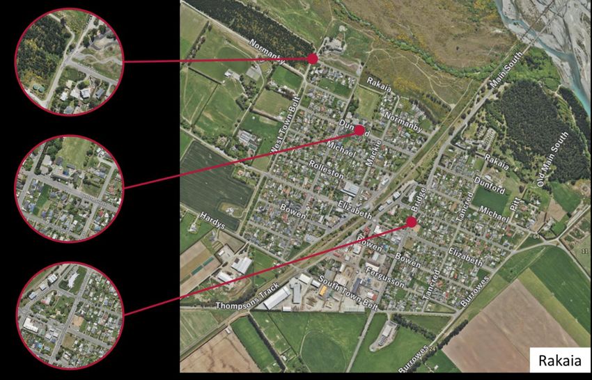
Executive Summary
Context

This Walking and Cycling Strategy provides a framework for making walking and cycling (both for transport and
recreation) safe and attractive, and therefore increasing the number of people walking and cycling. Walking includes the
use of mobility scooters, wheelchairs and recreational devices such as skateboards and scooters. Cycling includes the
use of human powered bicycles and electric bicycles (E-Bikes).

The Strategy is a result of reviewing current walking and cycling provision, engaging with residents through an online
survey and a workshop with key stakeholders. The key stakeholders were representatives from: Ashburton District
Council, NZ Police, Tinwald Cycling Club, Bike Methven, Safer Ashburton, Sport Mid Canterbury, Mobility Solutions
Centre, Braided Rivers Cycle Trust, NZ Transport Agency, Mid Canterbury Principal Association, Rakaia Community
Association, Mid Canterbury Mountain Bike Club, Run and Walk Ashburton and Experience Mid Canterbury.

The 2008 Ashburton Walking and Cycling Strategy focused on the urban area of Ashburton. This Strategy includes
Ashburton, Methven and Rakaia. The smaller towns of Mayfield, Mt Somers and Hinds will be considered over time.
Since the 2008 Strategy much has been achieved in the district for walking and cycling. New footpaths and some cycle
lanes have been created and many kilometres of recreational trails and BMX/bike skills parks have been created by a
range of groups.

An online survey was undertaken for this Strategy, 164 people responded. It was found that more people regularly walk
in the district than cycle, but people spend more time cycling than walking, particularly at the weekend. The most
common reasons for walking and cycling were for recreation, social and health reasons. Only a small percentage of
people walked or cycled to work.

Vision and objectives of the Strategy

The vision and objectives for the Strategy were established and tested in conjunction with the key stakeholders at the
workshop. The vision has been retained from the 2008 Strategy to provide long term strategic continuity. However, the
number of objectives has been reduced from six to four to be more targeted in the approach.

Vision: More people, more active, more often

Objectives:
•    A coherent, safe and connected urban walking and cycling environment
•    A quality, fit for purpose recreational walking and cycling network that connects to key destinations
•    Ensuring the urban and rural walking and cycling networks integrate to create an accessible district
•    A District that is committed to walking and cycling for health, well-being, safety, environmental and economic
     reasons
Observations, residents survey and workshop

Site observations and counts were undertaken as part of the Strategy development, this exercise identified a range of
issues that were verified at the stakeholder workshop. The online survey also verified the issues raised. The key
challenges people raised were:
•    walking - rough/uneven surfaces, lack of footpaths and crossing facilities, narrow footpaths, unsuitable transition
     from road to footpath, footpath gradient and others such as poor street lighting and sharing with cyclists.
•    cycling - a lack of cycle facilities separated from traffic, lack of defined cycle routes and cycle routes to key
     destinations, lack of crossing facilities/treatments at intersections, poor connections on existing routes lack of cycle
     parking, rough/uneven surfaces and others such as motorcyclists on tracks, sharing with runners, poor signage.

The survey found that only 5% were very satisfied with the current overall walking environment in the district, 40% were
mostly satisfied, 34% were neither satisfied or dissatisfied, 13% were mostly dissatisfied and 8% were very dissatisfied.

The survey found that 7% were very satisfied with the current overall cycling environment in the district, 51% were mostly
satisfied, 21% were neither satisfied or dissatisfied, 16% were mostly dissatisfied and 5% were very dissatisfied.

 Our Ref:                        Issue Date:                                                                           i
 Ashburton District              10 February 2020
 Walking and Cycling
 Strategy_FINAL 10 Feb
 2020
The issues as they relate to the Strategy objectives are outlined below.

Objective 1: A coherent, safe and connected urban walking and cycling environment

    ➢    Issue 1.1: Pedestrian accessibility is being restricted by poor facilities
    ➢    Issue 1.2: There are gaps in the footpath network
    ➢    Issue 1.3: Roads with cycle lanes have continuity and quality issues
    ➢    Issue 1.4: There is a lack of urban cycle facilities separated from traffic
    ➢    Issue 1.5: There are State Highway/railway/river severance issues for communities
    ➢    Issue 1.6: Standards such as widths of footpaths need review in light of the range of footpath users
    ➢    Issue 1.7: Personal security issues due to poor street lighting
Objective 2: A quality, fit for purpose recreational walking and cycling network that connects to key destinations

    ➢    Issue 2.1: There is a lack of effective wayfinding within some of the recreational networks
    ➢    Issue 2.2: There is a lack of consolidated track specifications that can be shared across groups
Objective 3: Ensuring the urban and rural walking and cycling networks integrate to create an accessible district

    ➢    Issue 3.1: There are gaps in the footpath and cycle network connecting urban and rural areas
    ➢    Issue 3.2: There is a lack of wayfinding to access recreational networks from urban areas
Objective 4: A District that is committed to walking and cycling for health, well-being, safety, environmental and
economic reasons

    ➢    Issue 4.1: There is a lack of co-ordination with respect to increasing participation in walking and cycling
    ➢    Issue 4.2: There is a lack of consolidated information on cycling routes in the district
    ➢    Issue 4.3: Development planning through the District Plan is not aligned with best practice on some matters

Implementation Plan

The vision of the Strategy will be achieved through a range of means. The Strategy Implementation Plan outlines the
actions and projects that aim to address the issues and meet the objectives. Fixing accessibility issues, the provision of
footpaths on at least one side of each street in Rakaia and Methven and an urban cycleway network in Ashburton are
key elements of the Plan. Cycle networks for Rakaia and Methven have not been developed at this stage as the streets
are lower volume and the focus is on footpaths in the short term.
There are also new crossing facilities, intersection improvements and SH projects that will help address severance
issues. The second urban bridge over the Ashburton River would greatly benefit walking and cycling. Projects identified
in other ADC Plans and the Minor Improvements Activity List will also contribute to meeting the Strategy vision and
objectives.

Actions that aim to increase participation in walking and cycling are also a key part of the Implementation Plan.

Monitoring and review

Monitoring and review are an important part of this Strategy, a Walking and Cycling Working Group will be formed to
undertake this. The group will compromise ADC staff and members that represent key stakeholders. An ADC staff role
to co-ordinate and take ownership of the Strategy will be required.

The actions and projects outlined in the Implementation Plan will be monitored for progress. Progress, and monitoring
information will be reported through the Working Group, as and when that information is available. A brief overall Annual
Report on progress in the implementation of the Strategy will be prepared as part of Council’s overall annual reporting.

In addition to the actions and projects several key aspects will be monitored, these relate to uptake and participation,
progress on cycling infrastructure (as this is where the most effort is required) and community satisfaction.

 Our Ref:                         Issue Date:                                                                          ii
 Ashburton District               10 February 2020
 Walking and Cycling
 Strategy_FINAL 10 Feb
 2020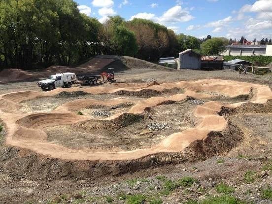
Contents
1.       About this Strategy                             1
1.1      Introduction                                    1
1.2      What have we achieved so far?                   1
2.       Our Vision and objectives                       2
3.       How do we align?                                3
3.1      Nationally                                      3
3.2      Regionally                                      3
3.3      Locally                                         4
4.       Our district and community                       7
4.1      Lay of the land                                  7
4.2      Our community                                    7
4.3      How and where we travel                          7
4.4      Safety                                          10
5.       The key issues we face                          11
5.1      Rakaia                                          11
5.2      Methven                                         12
5.3      Ashburton                                       13
5.4      Summary of issues                               14
6.       Our walking network                             15
6.1      Types of walking                                15
6.2      Current provision                               15
6.3      Proposed process actions                        16
6.4      Proposed improvement projects                   17
7.       Our cycling network                             18
7.1      Types of people who cycle                       18
7.2      Current provision                               19
7.3      Proposed process actions                        19
7.4      Proposed improvements                           20
7.5      Future provision                                21
8.       Developing participation                        23
8.1      Past and current initiatives                    23
8.2      Proposed initiatives                            23
9.       Priorities and implementation programme         24
10.      Monitoring and review                           25
Appendix A – Walking and cycling counts
Appendix B – Maps of proposed projects
Appendix C – Implementation Plan

 Our Ref:                   Issue Date:            iii
 Ashburton District         10 February 2020
 Walking and Cycling
 Strategy_FINAL 10 Feb
 2020
1.         About this Strategy
1.1        Introduction
This Walking and Cycling Strategy provides a framework for making walking and cycling (both for transport and
recreation) safe and attractive, and therefore increasing the number of people walking and cycling. Walking includes the
use of mobility scooters, wheelchairs and recreational devices such as skateboards and scooters. Cycling includes the
use of human powered bicycles and electric bicycles (E-Bikes).

The development of a safe and attractive walking and cycling network requires investment over time. This Strategy
facilitates a multi-party approach and provides Ashburton District Council (ADC), other funding agencies such as NZ
Transport Agency, and community organisations with priorities and strategic direction for investment. It also provides the
context and support for associated funding business cases.

The Strategy is a result of reviewing current walking and cycling provision, engaging with residents through an online
survey and a workshop with key stakeholders. The key stakeholders were representatives from: ADC, NZ Police,
Tinwald Cycling Club, Bike Methven, Safer Ashburton, Sport Mid Canterbury, Mobility Solutions Centre, Braided Rivers
Cycle Trust, NZ Transport Agency, Mid Canterbury Principal Association, Rakaia Community Association, Mid
Canterbury Mountain Bike Club, Run and Walk Ashburton and Experience Mid Canterbury.

The 2008 Ashburton Walking and Cycling Strategy focused on the urban area of Ashburton. The subsequent ADC
Sports and Recreation Strategy (2010) recommended that the Strategy be extended to include Methven and Rakaia –
this 2019 Strategy does that. Many of the Strategy objectives are also relevant to the smaller towns of Mayfield, Mt
Somers and Hinds, however specific infrastructure projects for those towns have not been included at this time. The
intent is that the Strategy is a living plan and that projects could be added over time.

1.2        What have we achieved so far?
Since the 2008 Strategy much has been achieved in the district for walking and cycling. New footpaths have been
created and maintenance of footpaths continues. Work in each township is outlined below.

In Methven the Lions Club and Methven & Mt Hutt District Promotion Association established the Methven Walkway.
More recently a BMX Track/Bike Skills Track was created by Track & Trail and Bike Methven club volunteers. The BMX
Track received a grant from the NZ Community Trust (NZCT). Nearby the Mt Hutt Bike Park has been created, this
includes over 30km of cross country, downhill and single-track trails.

In Rakaia the Rakaia River Terrace Walkway has been transformed from a bulldozed track along the riverbank to a solid
stone and clay surface walkway. The aim was to ensure people walking with prams could use the walkway. A BMX
track has also been established in the town.

In Ashburton cycle lanes were added to part of Harrison Street. In Tinwald the Braided River Trail to Lake Hood (south
side of the Ashburton River) and Ashburton/Hakatere River trail to Hakatere (north side of the river) were established. A
shared path connection to Lake Hood along Grahams Road has also been constructed, providing an alternative to the
Braided River Trail. The Braided Waters Cycle Trail continues to be developed and aims to provide a 3m wide trail
following some of the district's braided rivers and a network of canals, up
to 145km in length, to cater for a 3 to 4 day ride.

The River Trail Loop was also established on the north side of the river,
encompassing the Ashburton/Hakatere River trail. The loop has been
developed since 2009 by members of the Mid Canterbury Mountain Bike
Club with support from Environment Canterbury and ADC. The 12km
loop is suitable for most people with some mountain biking experience
and is also E-Bike friendly. The main entrance and car park for the loop
is on Dobson Street West. The ACL Skills Park is the latest addition to
the River Trail Loop located near the main entrance. It contains many
features for riders to practice their skills on. Funding came from the Lions
Foundation and ADC.

 Our Ref:                        Issue Date:                                                                       1
 Ashburton District              10 February 2020
 Walking and Cycling
 Strategy_FINAL 10 Feb
 2020
2.            Our Vision and objectives
The vision and objectives for the Strategy were established and tested in conjunction with the key stakeholders at the
workshop. The vision has been retained from the 2008 Strategy to provide long term strategic continuity. However, the
number of objectives has been reduced from six to four to be more targeted in the approach.

                                                              Vision

                                        More people, more active, more often

                                            Walking and Cycling Objectives

1)     A coherent, safe and connected urban walking and cycling environment

       This objective includes the development of facilities that provide for the needs of people in the urban areas, not just
       for movement but also infrastructure such as cycle parking and seats for resting. Coherent relates to networks being
       easy to use and find, safe relates to reducing conflict between traffic and people and personal security; connected
       relates to networks being complete with no gaps and that they link to key destinations.

2)     A quality, fit for purpose recreational walking and cycling network that connects to key destinations

       This objective recognises that recreational networks will have a range of users and that clear design approaches will
       need to be established. The quality aspect relates to ensuring the standards are met. Fit for purpose relates to
       recognising that not all tracks will have the same level of quality. For example, a mountain bike park will cater for a
       range of skill levels, not each track will not suit all people.

3)     Ensuring the urban and rural walking and cycling networks integrate to create an accessible district

       This objective includes ensuring that urban and rural (mostly recreational trails) networks are integrated in terms of
       linkages and also transitions between them. For example, where people in an urban area might currently drive to the
       start of a trail nearby, in future they can walk or ride to the facility. Wayfinding signage and good map information will
       be important. Communication between the various groups on the interface of urban and rural networks needs to be
       strong.

4)     A District that is committed to walking and cycling for health, well-being, safety, environmental and
       economic reasons

       This objective reflects the need for leadership and that action will only occur if groups work together. Actions may be
       triggered by various reasons and across many sectors. Actions will include promoting walking and cycling and also
       encouraging travel behaviour change. Commitment will be reflected through resource and funding allocation. It was
       agreed at the workshop that ADC need to take a key leadership role.

     Our Ref:                        Issue Date:                                                                          2
     Ashburton District              10 February 2020
     Walking and Cycling
     Strategy_FINAL 10 Feb
     2020
3.           How do we align?
The Walking and Cycling Strategy should align with national, regional and local strategies/plans. Each of the relevant
strategies and plans are discussed below in the context of walking and cycling.

3.1          Nationally
Government Policy Statement 2018
The Government Policy Statement (GPS) on Land Transport 2018/19 – 2027/28 guides national investment, identifies
where the Government will focus resources and guides the NZ Transport Agency and local government transport plans.
Several of the results associated with the four strategic priorities (safety, access, environment and value for money)
relate to walking and cycling:

•     Significant reduction in deaths and serious injuries
      −   Cycling and walking is safer (short to medium term results (3-6+ years)
•     Sustainable economic development of regional New Zealand is supported by safer and better transport connections
      −   Improved transport connections (including local roads, public transport and active modes) on key regional tourist
          routes to make these routes safer for all
•     Increased mode shift from private vehicle trips to walking, cycling and public transport
      −   Improved good-quality, fit-for-purpose walking and cycling infrastructure
      −   Improved real and perceived safety for both pedestrians and cyclists
      −   Increased proportion of journeys made using public transport and active modes of travel (including travelling to
          and from school)
      −   Expanded and better connected walking and cycling networks both in urban and rural areas
•     Reduce transport’s negative effects on the local environment and public health
      −   Increased uptake of active travel modes such as walking and cycling to support environmental and public health
          objectives
The focus on active transport in the GPS is supported by the walking and cycling improvements activity class in the
National Land Transport Programme which provides a dedicated funding pool for walking and cycling.

3.2          Regionally
Regional Land Transport Plan 2018
The Regional Land Transport Plan (RLTP) 2015-2025 sets out the regional land transport priorities. Of relevance to
walking and cycling are the key challenges identified in the plan, including:

•     Improving safety outcomes for all transport users
•     Ensuring transport makes a positive contribution to the health of Cantabrians
•     Maintaining and improving levels of access and mobility in an environmentally sustainable manner

While the priorities and objectives do not explicitly include walking and cycling, several relate to active travel:

•     Improve road safety
•     Improved effectiveness of passenger and active transport
•     Environmental sustainability
•     Safe, healthy and connected communities

Of note for the district, the ten-year expenditure plan includes the Ashburton Urban Walking and Cycling Programme as
a regional project for 2018/19.

    Our Ref:                       Issue Date:                                                                         3
    Ashburton District             10 February 2020
    Walking and Cycling
    Strategy_FINAL 10 Feb
    2020
3.3          Locally
Long-Term Plan 2018-28
The vision for the district is outlined in the Long Term Plan as: ‘Ashburton District – The district of choice for lifestyle
and opportunity’. This sets out an aim to grow and sustain Ashburton as a district that people choose for the high-
quality lifestyle and opportunities available here. Our vision is supported by the community outcomes that set out our
long-term goals and guide our activities. The outcomes are:

      •    Residents are included and have a voice
      •    A district of great spaces and places
      •    A balanced and sustainable environment
      •    A prosperous economy based on innovation and opportunity

The vision and the outcomes align well with this Strategy.

The Long-Term Plan (LTP) 2018-2028 specifies Ashburton District Council’s intentions for the decade and its funding
mechanisms. The LTP lists eight priorities identified by residents for Council spending. Many of these relate to walking
and cycling, including roading, community safety, environment, town centre development and second bridge
development in Ashburton. These priorities are reflected in the major projects specified in the LTP, which include the
roading network and transportation upgrades.

The high-level goal for transportation is “To enable efficient travel throughout the district to support economic activity and
social interaction”. The community outcomes relating to walking and cycling include:

•     A district of great spaces and places
      − Roads support the community to carry out their business, leisure and social activities in a safe and reliable way
         that is fit for purpose
      − Footpaths and cycleways support the community to connect and enable residents and visitors safe and smooth
         travel
      − Council provides open spaces that are attractive for residents and visitors
      − Council provides environmental health services to assist great spaces and places for the community
•     A prosperous economy based on innovation and opportunity:
      − Footpaths help promote economic activity, particularly in the central business areas of the district

District Plan
The Ashburton District Plan provides the planning framework for the district. It encourages the development of
pedestrian areas, walking tracks, and cycle ways, especially on the approaches to all schools to improve amenity and
accessibility for residents. The plan recognises that the issue of connectivity can be addressed through design of access
for walking and cycling. Linkages both within and beyond subdivisions are crucially important to ensure connectivity,
especially for pedestrians and cyclists. The location, design and layout of such connections should consider the safety of
users of these spaces. For new residential areas an Outline Development Plan forms the basis for ADC to review and
shape walking and cycling provision as per the policies.

The plan requires footpaths on both sides of urban arterial roads, other roads are required to be in accordance with a NZ
Standard (NZS4404:2010). The Plan requires that footpaths shall be constructed as a sealed strip of 1.5m width within
the berm. There is currently no requirement for cycle parking for new developments.

The District Plan is to be reviewed in 2020.

    Our Ref:                       Issue Date:                                                                         4
    Ashburton District             10 February 2020
    Walking and Cycling
    Strategy_FINAL 10 Feb
    2020
Strategies, plans and projects
There are a range of relevant local strategies, plans and proposed infrastructure projects. Table 3.1 summarises their
relevance, influence or impact (ordered by date) on the Walking and Cycling Strategy

Table 3.1 Local strategies, plans and projects and how they relate to walking and cycling

 Strategy/Plan                           Influence/impact on the Walking and Cycling Strategy

 Methven Community Strategic             A BMX track was an action of the Plan, this is now completed. 2014 progress report:
 Plan (2009)                             The walkway around the golf course has continued to be developed by volunteers. It
                                         will be included as a priority in the next Strategic Plan and will be further developed
                                         accordingly.

 Rakaia Community Strategic Plan         A BMX track was an action of the Plan, this is now completed. The Plan advocates for
 (2009)                                  safe traffic movement (including walking and cycling) on the Rakaia Bridge and safe
                                         crossing of SH1 through the town.

 Sports and Recreation Strategy          This Strategy has a strong link to the Walking and Cycling Strategy. It recognises the
 (2010)                                  importance of urban form and cycleway networks. It also recognises that participation
                                         is important and that while the benefits of active transport are recognised – the
                                         motivation is the point of difference.

 Tinwald Domain Future                   This document includes a proposed path network through and around the Domain that
 Development Resource Document           will support the overall Tinwald walking and cycling environment. A link to a proposed
 (2010)                                  subdivision is also proposed as is a Heritage Trail to Ashburton.

 Economic Development Strategy           This Strategy recognised that developing the district as a ‘lifestyle location’ will involve
 and Action Plan (2012)                  the urban form efficiency and the appearance of the town. Heli-biking and expanding
                                         the mountain biking and cycleways were seen as key opportunities.

 Open Spaces Strategy (2016)             This Strategy promotes close proximity from homes to open space by walking (max 400
                                         metres). It supports cycleways for recreational purposes and recognises that
                                         waterways create recreational opportunities for walking and cycling.

 Transportation Asset Management         Aims to maintain smooth and even paths, acknowledging that providing good footpaths
 Plan (2018)                             supports demographic change towards an aging population. There is a condition rating
                                         process in place for footpaths. Limited detail on cycleways except for surface skid
                                         resistance.

 Ashburton Domain Development            This Plan includes a proposed cycle path through the Domain and on Walnut Ave and
 Plan – Draft for Consultation           Oak Ave. A walk/cycle link between the ACL Skills Park and the proposed sports field
 (2019)                                  next to the EA Networks Sports Centre is also proposed.

 Projects                                Influence/impact on the Walking and Cycling Strategy

 Ashburton Town Centre                   This project includes wider footpaths and more resting places, a 30km/hour speed limit
 Streetscape Renewals (being             in the Town Centre core, widening the shared path on the East Street reserve, and new
 constructed over next few years)        and improved cycle parking.

 Ashburton Second Urban River            If this project proceeds the benefit to walking and cycling are vast. It would provide an
 Bridge                                  alternative to the narrow SH1 bridge paths. It is shown on the proposed network as a
 (Business Case currently being          potential link.
 prepared)

 NZTA - Tinwald Corridor Strategic       This project has potential to help address severance issues in Tinwald however no
 Business Case completed 2015            plans of changes to the road layout are available at this stage.

 NZTA - Selwyn River to Ashburton        The consultation phase identified people have concerns walking and/or driving across
 safety improvements (Final Plan         SH1 at Rakaia. The proposed plan includes a speed limit review through Rakaia. No
 currently being developed)              plans of changes to the road layout are available at this stage.

 Our Ref:                           Issue Date:                                                                                  5
 Ashburton District                 10 February 2020
 Walking and Cycling
 Strategy_FINAL 10 Feb
 2020
Projects Influence/impact on the Walking and Cycling Strategy
ADC Minor improvement activity The list for the 2015-2018 programme include a range of projects that will support the
list Walk and Cycling Strategy:
• Grahams Street/Thomsons Street kerb protrusions
• Cass St / Tancred St: Improve safety at Ped Xing and compliance at Stop
control (part of CBD Streetscape project)
• Maronan Rd/Melcombe St/Henderson Rd: Upgrade intersection
• Cross St/Cavendish St/Harrison St, New Traffic Splitter Islands to make
intersection safer
• Chalmers Ave/Wellington St/Havelock St, New Traffic Splitter Islands
• Normanby St/West Town Belt intersection, New Traffic Splitter Islands
• Melcombe Street - Rail underpass to cater for cyclists and pedestrians and
remove conflict with motorists
• Ashburton Christian School - Improve overall safety outside schools in
relation to highlight the school location and additional pedestrian safety
measures
• Allens Rd/Alford Forest Rd intersection, new Traffic Splitter Islands
• Farm Rd/Alford Forest Rd intersection, new Traffic Splitter Islands
• New and upgraded streetlighting
Our Ref: Issue Date: 6
Ashburton District 10 February 2020
Walking and Cycling
Strategy_FINAL 10 Feb
20204. Our district and community 4.1 Lay of the land Ashburton District is centred on the town of Ashburton on the eastern side of the central South Island. With the Pacific Ocean coastline making up its eastern boundary and the Southern Alps forming its western boundary, Ashburton District is bordered to the north by the Rakaia River and to the south by the Rangitata River. The district, which covers around 6,175 square kilometres, has three territorial authority neighbours: Selwyn District to the north, Westland District to the west, and Timaru District to the south. The district has a physical environment that is conducive to walking and cycling within the urban centres due to the relatively flat terrain. The large distance between towns does not, however, lend itself to walking and cycling between urban centres for transport, but recreational opportunities exist. Mountainous terrain to the west provides mountain biking opportunities. Within the rural network many of the roads have narrow carriageways, little or no shoulders and support significant volumes of high speed traffic. 4.2 Our community The population of the Ashburton District was 33,423 people in 2018 (Census NZ). This is a 22% increase from the 2006 population and greater than the nationwide population increase of 17% over the same period. Of the three centres focussed on in the strategy, the greatest population increase occurred in Rakaia (34%). Methven’s population increased by 27% and the combined population of Ashburton and Tinwald increased by approximately 19%. The Ashburton District has a slightly higher proportion of people aged 65 years and over (18% compared to 15% of the NZ population). The number of residents aged under 15 years has increased by 20% since 2006, compared to a nationwide increase of 6%. Both the number of people aged 15-29 years and 65 years and over have increased by 34% since 2006. The high population growth for these age groups is an important consideration for the District’s walking and cycling strategy because children and older people tend to have different physical, cognitive and sensory abilities and increased risk of injury compared to the rest of the population. Of the resident population 93.5% work in the Ashburton District and 6.5% travel outside of the district for employment. 4.3 How and where we travel Travel by car is the predominate form of transport in Ashburton district. There are no public transport options. Car ownership Households in the Ashburton District have more access to motor vehicles for private use than wider New Zealand. In 2013, the majority of households in both the Ashburton District and wider New Zealand had two motor vehicles available for private use. 96% of households in the Ashburton District have access to a motor vehicle, whereas only 92% of the total households in New Zealand have access to a motor vehicle. On average, Ashburton households have more motor vehicles than wider New Zealand, with 62% having access to multiple vehicles compared to 55% nationwide. The number of motor vehicles available for private use to households did not change significantly from 2006 to 2013 for either Ashburton District or wider New Zealand. The greatest change was that the proportion of households in Ashburton without access to a private vehicle decreased from 5.4% to 4.4%. Our Ref: Issue Date: 7 Ashburton District 10 February 2020 Walking and Cycling Strategy_FINAL 10 Feb 2020
Household travel data
Household travel data is gathered during the Census conducted by Statistics New Zealand every 5 or so years.
‘Population’ is the employed, usually resident, population aged 15 years and over. The data only surveys the mode of
travel to work, therefore, recreational, nonworking, and school aged walking and cycling levels are not measured. As a
result, this may underrepresent the true extent of cycling and walking / jogging in the district.

Figure 4.1 shows a comparison of active transport (walking / jogging and cycling) statistics for the journey to work for the
Ashburton District compared to the overall 2001, 2006 and 2013 New Zealand results. The data shows the proportion of
people that walk or cycle to work are higher than national averages, however, the proportion dropped in each
consecutive census from 2001 to 2013. The 2018 Census household travel data is not yet available.

Figure 4.1 Household Travel Survey Data (Source: Statistics New Zealand 2013 Census Data: Working Population Main Mode of
Transport to Work.)

Residents’ survey on walking and cycling
An online survey was posted on the ADC Facebook page in August/September 2019. 164 people took part in the
survey; 17 from Rakaia, 7 from Methven, 113 from Ashburton and 17 from rural areas. 57% of the people were female
and 43% were male. 6% of people stated they had a disability, mostly physical and some visual. The majority of survey
respondents were aged 35 to 64 (66%), next was 18 to 34 (18%) and then 65 to 84 (13%). Only 2% of the respondents
were aged under 18 years and 1% were over 85 years old.

The survey asked people for what purposes they walked or bicycled. For walking the most common reasons were for
recreational/social/health (58%), 14% travelled to and from school (including as parents) and 7% walked to and from
work. For cycling, the most common reasons were for recreational/social/health (60%), 9% travelled to and from school
(including as parents) and 4.5% cycled to and from work. 10% of the 111 who responded to this question cycled to and
from work in combination with another transport choice, this could have included people driving in from a rural location
and parking on the edge of the town then continuing by bicycle.

The key destinations for people walking and cycling were, in descending order of popularity:

         Park/recreation centre                                      Other - mainly cycle tracks
         Shops                                                       Park
         Cafe/restaurant/bar                                         Cafe/restaurant/bar
         Work                                                        Shops
         Other – mainly walking tracks                               Community centre/community facility
         Schools                                                     Work
         Bank/post office                                            Schools
         Community centre/community facility                         Bank/post office
         Museum(s)                                                   Museum(s)

 Our Ref:                         Issue Date:                                                                           8
 Ashburton District               10 February 2020
 Walking and Cycling
 Strategy_FINAL 10 Feb
 2020
The survey asked how often people walked or cycled and how much time they spent doing so on a weekday and at the
weekend. People were able to make comments in relation to this. They were also asked what key challenges existed
for walking and cycling and whether they have any ideas on what could be improved. These aspects are discussed
below.
How often do you walk in the Of those who walked - Of those who walked -
Ashburton District? Approximately how much time do Approximately how much time do
you spend walking on a weekday? you spend walking on the weekend?
Key challenges for walking were rough/uneven surfaces (63%), lack of footpaths (25%) and crossing facilities (38%),
narrow footpaths (24%), unsuitable transition from road to footpath (21%), footpath gradient (15%) and others such as
poor street lighting and sharing with cyclists. Respondents could choose multiple challenges.
How often do you cycle in Of those who cycled - Of those who cycled - Approximately
the Ashburton District? Approximately how much time do how much time do you spend cycling on
you spend cycling on a weekday? the weekend?
Key challenges for cycling were a lack of cycle facilities separated from traffic (62%), lack of defined cycle routes and
cycle routes to key destinations (48%), lack of crossing facilities/treatments at intersections (38%), poor connections on
existing routes (33%), lack of cycle parking (29%), rough/uneven surfaces (22%) and others such as motorcyclists on
tracks, sharing with runners, poor signage. Respondents could choose multiple challenges.
Our Ref: Issue Date: 9
Ashburton District 10 February 2020
Walking and Cycling
Strategy_FINAL 10 Feb
20204.4 Safety People walking and cycling can encounter a range of safety issues including falls when walking, crashes between pedestrians and people on bicycles, crashes with motor vehicles and personal security. Falls are causes by trips, slips and stumbles. Around 700 pedestrians are admitted to hospital each year as a result of slips, trips and stumbles in the NZ road environment, and so the problem is not insignificant. Falls can be reduced by ensuring walking surfaces are smooth, slip resistant, have appropriate cross fall and have no unexpected level changes. Crashes between pedestrians and people on bicycles generally occur on footpaths and shared paths or when someone is crossing the road and the cyclist is riding on the road. These types of crashes are often related to people not looking out for each other. Design considerations include shared paths being designed to ensure the width is suitable for the expected volume and type of pedestrians and cyclists. Crashes with motor vehicles that were attended by the Police are recorded in the national Crash Analysis System (CAS). In the previous five years (2014-2018), 33 crashes involving pedestrians or cyclists have been reported in the Ashburton District. Of these, two resulted in fatalities, eight in serious injuries and 20 in minor injuries. One occurred within the vicinity of Rakaia, two were located in Methven, 26 were in the vicinity of Ashburton/Tinwald and four occurred in more rural locations. Of the crashes occurring within urban areas, it is notable that eight crashes involved failure to give way to cyclists at intersections, six involved vehicles failure to notice and give way to footpath users at driveways and three involved doors of parked cars. These crash causes are important to consider in the design of facilities and best practice guidance aims to help reduce the risks associated with these types of conflicts. Speed management is another aspect to consider as when the speeds of motor vehicles are higher than approximately 30km/hour the likelihood of a pedestrian or cyclist surviving the crash is low. Personal security relates to feeling safe from an act of crime when out walking or cycling. This can be addressed to some extent through the design of the environment through which a person is travelling. Crime Prevention Through Environmental Design, (CPTED), is an approach which uses design to create naturally safer environments with less reliance on law enforcement. CPTED aims to reduce opportunities for crime and antisocial behaviour through designing environments that make committing these acts less easy – reducing opportunities for crime to occur. Examples include walking accessways that are wide and not landscaped in a way that a person could hide in wait, ensuring walkways are overlooked by neighbours (e.g. lower fences) and better street lighting. Our Ref: Issue Date: 10 Ashburton District 10 February 2020 Walking and Cycling Strategy_FINAL 10 Feb 2020
5. The key issues we face
5.1 Rakaia
Rakaia is located on the south bank of the Rakaia River and is the northern gateway to Ashburton District. The
population is approximately 1,200 people. Rakaia is a rural servicing town, with a growing industrial commercial base
with innovative engineering firms specialising in agricultural and marine products. Rakaia is widely known as the
'Salmon Capital' of New Zealand due to the salmon and trout able to be caught in the Rakaia River. Strengths of the
recreation opportunities available in and around Rakaia are largely focused on sport and outdoor recreation, such as the
Rakaia Domain, the Rakaia Swimming Pool and the new Rakaia River Terrace Walkway (3.2 kilometres). Facilities and
services within the town are generally in walking distance and easily accessible.
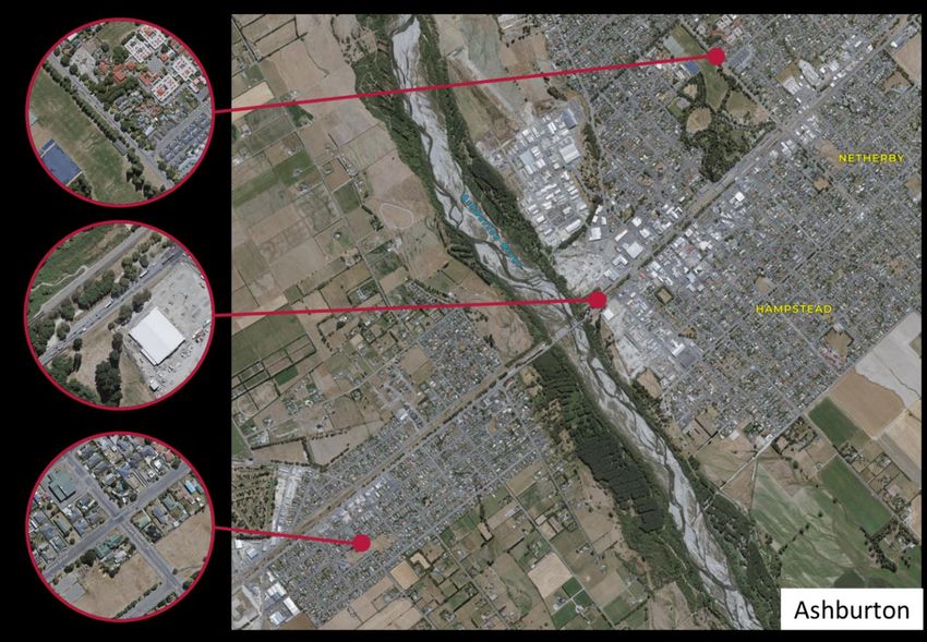
Pedestrian and cyclist counts were undertaken at the school, around the recreational tracks and State Highway 1. See
Appendix A for the count sites and results.
Key observations, as represented in the graphic, included a relatively
high proportion of school children walking/cycling to school
unaccompanied, some elderly people having to go ‘cross-country’ due
to a lack of walking infrastructure, and some recreational walkers
making use of the tracks in the north of the town.
32% of the school roll were observed walking/cycling/scootering to
school on the day, which is relatively high.
Key issues identified were severance making it hard to get between
destinations due to the railway line and State Highway 1, heavy
vehicles impacting walking space and visibility, and a lack of facilities
to support walking and crossing along key routes. Footpath
installation on streets with no footpaths is currently on hold while EA
Networks installs underground power cables.
The key issues and suggestions from the resident’s online survey
were:
• Lack of safe pedestrian and cycle crossing of State Highway 1 at existing intersections
• Lack of pedestrian and cycle routes to key destinations
• Lack of good street lighting in winter
• Unsafe transitions from road to footpath
• Pedestrian /cycle bridge over the Rakaia Bridge – for locals and tourists
• Slower speeds sought through Rakaia
Our Ref: Issue Date: 11
Ashburton District 10 February 2020
Walking and Cycling
Strategy_FINAL 10 Feb
20205.2 Methven
Located at the base of the Southern Alps, Methven is an agricultural service centre and ski village. It has a large
agricultural community while also being the gateway to Mount Hutt skifield and other adventure tourism opportunities.
Methven has a permanent population of around 1,600 but each year this swells significantly over winter when a
significant number of visitors come for the ski season. People are attracted to Methven by the lifestyle and the proximity
to the picturesque foothills and high country. Within the town there is easy access to facilities and services as all are
within walking distance.
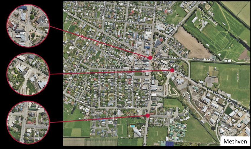
Pedestrian and cyclist counts were undertaken around the school accesses and the town centre. See Appendix A for
the count sites and results.
Of the total number of students enrolled at Mt Hutt College and
Methven Primary School, 25% were observed
walking/scootering/cycling/skating home from school. Scooters
were particularly popular compared to the other towns. Children
were observed cycling on the 3m wide footpaths along the SH in
an orderly and courteous manner.
There was also a lot of activity around the central intersection,
including tourists. This intersection was reasonably complex for
people to cross. Many of the footpaths in this central area were
cluttered with street furniture creating several pinch points.
Key issues identified were a lack of facilities to support pedestrian
activity around the central intersection (Main Street / Methven
Chertsey Road / Forest Drive / The Mall), a lack of support for
cycling near the schools on Main Street and
wayfinding/infrastructure for the Methven Walkway.
The Opuke Thermal Pools (under construction near the raceway) will become a key destination and therefore a footpath
connection is required. Ongoing residential developments in the northern and western greenfield areas of the town could
add 100 houses, this highlights the importance of future proofing connections.
The key issues from the resident’s online survey were:
• Lack of sealed cycle lanes - Methven Golf Course and Alford Forest Roads
• Lack of cycle routes to key destinations
• Residents like wide footpaths
• Rough/uneven surfaces on cycle routes
Our Ref: Issue Date: 12
Ashburton District 10 February 2020
Walking and Cycling
Strategy_FINAL 10 Feb
20205.3 Ashburton
Ashburton is the central hub of the Ashburton District. With a population of approximately 18,000 it is the main
commercial and service centre for the surrounding farming district. Located on State Highway 1, Ashburton is both well
positioned and accessible for residents and visitors to the district. Ashburton has strong financial and legal services as
well as other business support such as engineering, automotive and agricultural machinery and goods.
Pedestrian and cyclist counts were undertaken on Walnut
Avenue outside Ashburton College, on Graham Street near
Tinwald School and at the Ashburton River bridge. See
Appendix A for the count sites and results.
Walnut Ave was the busiest count site with 216 people
observed. Walking was the predominant mode (87%) with a
wide range of pedestrians observed, including people using
mobility scooters, wheelchairs and other devices. Notably
there were only 26 bikes on site at Ashburton College (roll of
200) once school started. Scootering is a popular way to
travel for primary school children.
The key issues identified for Ashburton (including Tinwald)
were severance due to the Ashburton River, the railway line
and State Highway 1, a lack of facilities to support walking and
crossing at key intersections and poor quality cycle
provision/use.
Generally, there are footpaths on both sides of the roads in
Ashburton and Tinwald.
The key issues from the resident’s online survey were:
• State Highway and rail line severance e.g. access to
the Domain
• Lack of safe road crossings (Tinwald)
• Roads are unsafe for cycling
• Some footpaths are too narrow
• Lack of cycle facilities and smooth surfaces
• Ashburton Bridge too narrow for pedestrians and cyclists
The majority of pedestrians/cyclists crossing the SH1 Ashburton River bridge used the path on the eastern side of the
bridge. The narrow paths make passing other users very difficult. People report feeling very uncomfortable on the
bridge paths.
Our Ref: Issue Date: 13
Ashburton District 10 February 2020
Walking and Cycling
Strategy_FINAL 10 Feb
20205.4 Summary of issues
The issues discussed in this section have been summarised and associated with one of the Strategy Objectives to
provide structure when developing actions to help meet the objectives.
Objective 1: A coherent, safe and connected urban walking and cycling environment
➢ Issue 1.1: Pedestrian accessibility is being restricted by poor facilities
➢ Issue 1.2: There are gaps in the footpath network
➢ Issue 1.3: Roads with cycle lanes have continuity and quality issues
➢ Issue 1.4: There is a lack of urban cycle facilities separated from traffic
➢ Issue 1.5: There are State Highway/railway/river severance issues for communities
➢ Issue 1.6: Standards such as widths of footpaths need review in light of the range of footpath users
➢ Issue 1.7: Personal security issues due to poor street lighting
Objective 2: A quality, fit for purpose recreational walking and cycling network that connects to key destinations
➢ Issue 2.1: There is a lack of effective wayfinding within some of the recreational networks
➢ Issue 2.2: There is a lack of consolidated track specifications that can be shared across groups
Objective 3: Ensuring the urban and rural walking and cycling networks integrate to create an accessible district
➢ Issue 3.1: There are gaps in the footpath and cycle network connecting urban and rural areas
➢ Issue 3.2: There is a lack of wayfinding to access recreational networks from urban areas
Objective 4: A District that is committed to walking and cycling for health, well-being, safety, environmental and
economic reasons
➢ Issue 4.1: There is a lack of co-ordination with respect to increasing participation in walking and cycling
➢ Issue 4.2: There is a lack of consolidated information on cycling routes in the district
➢ Issue 4.3: Development planning through the District Plan is not aligned with best practice on some matters
Our Ref: Issue Date: 14
Ashburton District 10 February 2020
Walking and Cycling
Strategy_FINAL 10 Feb
20206. Our walking network
This section outlines types of walking and how the District currently caters for this. Actions relating to process or
standards and infrastructure projects are then identified to help address the issues raised in this Strategy.
6.1 Types of walking
Walking includes the use of mobility scooters, wheelchairs and recreational
devices, such as. skateboards and scooters. People walking have a range of
physical and cognitive abilities. The walking network needs to cater for the
needs of all these users, but the approach that if you cater for those less able
then you cater for everyone is considered best practice. Sometimes this
means ensuring there is choice, for example if there are steps on the route
then an alternative should be provided and it made clear where the alternative
route is.
Footpaths enable pedestrians to get to and from their place of work or school
and move around the community to meet in social, sporting, work or cultural
events. A safe and effective footpath network helps the environment by
encouraging people to walk or jog to their destinations rather than drive.
6.2 Current provision
Ashburton District has a wide range of walking opportunities and infrastructure,
these opportunities can generally be categorised as:
➢ Urban footpaths/shared paths (sealed)
➢ Urban area walking tracks (usually unsealed and shared with cyclists)
➢ Rural walkways (unsealed)
There are shared paths on each side of the Ashburton Bridge and there is an
existing rail overbridge for pedestrians and cyclists, opposite the Domain near
Wills Street. The rail overbridge is a Heritage Structure. There are two
pedestrian level rail crossings between West Street and East Street in the town
centre.
Council maintains 233km of footpath, with 83% located within Ashburton
Township. The footpath inventory grows through subdivision construction and
annual Council capital programmes. Historically footpath assets were primarily
chipseal surfaced but current Council policy is to use asphaltic concrete (AC)
for any new or resurfaced footpaths. AC generally provides a smoother surface
and achieves longer life than chipseal. Approximately 87% of footpaths are
AC.
There are also footpaths in the parks and recreational areas managed by
another Council department – Open Spaces. These are maintained by either
Roading or Open Spaces dependent on cost efficiency and resources.
The footpath renewal programme includes replacing existing full width surfaced
footpaths with a combination of 1.5m wide AC surfaced paths and grass
(remainder).
As identified in the resident’s survey key challenges for walking were
rough/uneven surfaces, lack of footpaths and crossing facilities, narrow
footpaths, unsuitable transition from road to footpath and footpath gradient.
Other challenges include poor street lighting and sharing with cyclists.
Our Ref: Issue Date: 15
Ashburton District 10 February 2020
Walking and Cycling
Strategy_FINAL 10 Feb
2020The ADC Annual Residents Survey does not ask about how satisfied people are with the footpaths but when asked
where Council should be spending more money, the issue of footpath quality is raised by some residents. Two
comments from the 2018 Survey relate to use of paths for mobility devices:
• The footpaths are not in good condition. When I was wheelchair-bound, the footpaths were uneven. Going down
into the gutter it was uneven.
• There are potholes on the footpath. The footpaths – I’m now using a mobility scooter and I’ve just realised how
bad they are. I knew they were bad for walking, but they’re been even worse using the scooter and I have done
a lot of walking in the past.
The Strategy residents survey found that 5% were very satisfied with the current overall walking environment in the
district, 40% were mostly satisfied, 34% were neither satisfied or dissatisfied, 13% were mostly dissatisfied and 8% were
very dissatisfied.
It was observed that some intersections are challenging for pedestrians to cross, particularly roundabouts. There were
several intersections where kerb cutdowns do not exist or are in a location that put people in an unsafe position to cross.
Trip hazards exist at crossing points and tactile pavers that are meant to assist visually impaired people often direct them
incorrectly.
Footpath condition is measured from data
collected during footpath rating surveys.
ADC uses the assessment criteria for
footpath walkover inspections as shown in
Table 3.3 from the ADC Transportation
Asset Management Plan. Rating levels 1,
2 and 3 are deemed acceptable in terms of
level of service. Three full network surveys
have been completed - in 2010/11 (82% of
footpaths rated acceptable), 2014/15
(98%) and March 2018 (93%). The next
survey is planned for 2020/21.
There are no metrics for other parts of the walking routes, such as kerb cut downs that can create tripping hazards if
greater than a 6mm lip exists and can be located incorrectly directing people in the wrong direction.
ADC co-ordinates the programme of streetlight renewal and upgrades with EA Network’s undergrounding of overhead
power lines within urban areas, and ADC footpath renewals. There may be opportunities to proactively determine where
pedestrians are feeling unsafe and create a priority approach to streetlight renewals.
6.3 Proposed process actions
There are several process related actions that can help address the walking issues raised in this Strategy are outlined in
Table 6.1.
Table 6.1 Proposed walking improvement actions.
Action No. Description
Action 1 Footpath width standards – Currently the ADC specify 1.5m footpath widths in the District Plan and
the Transportation Asset Management Plan. A review of widths to cater for a more diverse range of
users and devices is required. Best practice is tending towards 1.8m as this allows two wheelchairs or
mobility scooters to pass each other.
Action 2 Kerb cut downs – Develop assessment and rating system for inclusion in the Transportation Asset
Management Plan and would also require maintenance funding allocation.
Action 3 Street lighting audits - Proactively determine where pedestrians are feeling unsafe and create a
priority approach to streetlight renewals.
Our Ref: Issue Date: 16
Ashburton District 10 February 2020
Walking and Cycling
Strategy_FINAL 10 Feb
20206.4 Proposed improvement projects
Future demand for new footpaths is mainly expected to arise from subdivisions where the paths are part of the
development. However, there is also a need to provide a footpath on some streets which currently have no footpath.
This is predominantly related to Rakaia.
It is noted that there are currently several projects identified in the ADC Minor Improvements activity list that would
improve the pedestrian environment. These include new splitter islands at intersections that can be used as refuges and
a pedestrian and cycle rail underpass at Melcombe Street in Tinwald.
The following projects were identified to improve the walking environment. The project numbering relates to a list of
walking and cycling projects developed as part of the Strategy. See Appendix B for the project locations. The cycling
projects are discussed in Section 7. Some projects benefit walking and cycling.
The projects that can help address the walking issues raised in this Strategy are outlined in Table 6.2.
Table 6.2 Proposed walking improvement projects
Project No. Description
Project 1 Fix local accessibility issues - Involves an audit of sites identified in the strategy field work and
forming a list of jobs (e.g. improving kerb cutdowns, providing refuge islands), possibly as
maintenance/minor works tasks.
Project 2 New footpaths (see Appendix A for the maps that show proposed new footpaths)
1) Constructing a footpath on at least one side of all urban roads in Rakaia
2) A new footpath connection to the Hot Pools in Methven
3) A new footpath connection to the ACL Skills Park on Dobson Street West and a footpath to
Tinwald Domain
Project 7 Moore Street crossing – Between West Street and Park Street - This was identified in the residents’
survey as being on a key desire line and a safe crossing is required.
Project 9 Walnut Ave/Oak Ave intersection - Improving pedestrian and cyclist safety and comfort at the
intersection. There is currently poor provision for walking and cycling, and the intersection is a key
connection between Ashburton College, Ashburton Domain, the hospital and the surrounding suburbs.
(linked to Project 3 as part of improving Walnut Ave cycle route)
Project 10 Walnut Ave/Chamber Ave intersection - Improving pedestrian and cyclist safety and comfort at the
intersection. There is currently poor provision for walking and cycling, and the intersection is within a
key suburban activity area, with the Netherby shops and main connector routes towards north
Ashburton and Hampsted. (linked to Project 3 as part of improving Walnut Ave cycle route)
Project 12 EA Networks Centre path - A pedestrian/cycle path around the EA Centre was identified as a key
priority in the stakeholder workshop. This is also identified in the Ashburton Domain Strategy.
Project 13 Methven main town centre intersection upgrade - The intersection of State Highway 77, Methven
Chertsey Road and Forest Drive was identified as a priority for pedestrian and cycle improvements in
Methven. The intersection links the key retail and hospitality areas and links to one of the main routes
to/from the Methven Primary School and Mount Hutt College.
Project 14 SH77 Methven Pedestrian crossing – Provision of a crossing, most likely a pedestrian refuge island
opposite the public toilets and park.
Project 15 Rakaia SH1 crossings - Severance was identified as a key issue for Rakaia. Improved crossings
over State Highway 1 are a priority. NZTA would be the lead agency.
Project 16 Tinwald SH1 crossings - Severance was identified as a key issue for Tinwald. Improved crossings
on State Highway 1 are a priority. NZTA would be the lead agency.
Project 18 Ashburton Second Bridge - The proposed Ashburton Second Bridge and associated upgrades on
Chalmers Avenue and in Tinwald provide an opportunity for improved walking and cycling facilities.
The second bridge should provide safe and comfortable walking and cycling facilities, and these need
to link to other key routes in Ashburton and Tinwald.
Our Ref: Issue Date: 17
Ashburton District 10 February 2020
Walking and Cycling
Strategy_FINAL 10 Feb
2020You can also read