Assessment of Suitable Habitat of Near Threatened Striped Hyena (Hyaena hyaena Linnaeus, 1758) Using Remote Sensing and Geographic Information System
←
→
Page content transcription
If your browser does not render page correctly, please read the page content below
Assessment of Suitable Habitat of Near Threatened Striped
Hyena (Hyaena hyaena Linnaeus, 1758) Using Remote
Sensing and Geographic Information System
Md. Shamshad Alam1*, Jamal A. Khan1, S.P.S. Kushwaha2, Reshu Agrawal2, Bharat J. Pathak3 and Sandeep
Kumar4
1
Department of Wildlife Sciences, Aligarh Muslim University, Aligarh-202 002, India
2
Forestry and Ecology Division, Indian Institute of Remote Sensing, Dehradun-248 001, India
3
Conservator of Forests, Wildlife Circle, Junagadh-362 001, India
Deputy Conservator of Forests, Wildlife Division, Sasan-Gir, Junagadh-362 135, India
4
Abstract
Application of Remote Sensing and Geographic Information System as a tool has assumed immense significance in habitat
suitability modelling for various wildlife species. Models are now widely used in wildlife management and conservation ecology.
This study evaluated the habitat suitability for striped hyena (Hyaena hyaena Linnaeus 1758) in Gir National Park and Sanctuary,
in Gujarat province of India. The satellite imagery and topographic maps were used to generate spatial data pertaining to different
variables viz., forest type, forest density, measures of proximity to potential source of disturbances and water. A Digital Terrain
Model was used to create slope, aspect, elevation and spatial data layer. The locations of striped hyena presence were used in
a binomial multiple logistic regression model for striped hyena habitat suitability analysis. Results indicate that 78.51% of Gir
area is highly suitable to suitable for the striped hyena. The study predicted striped hyena habitat with high accuracy. The model
output can easily be understood by wildlife managers and experts. The results, besides having great practical importance would
serve as baseline for future management planning for the conservation of this globally near threatened species.
Key words: Habitat suitability model, striped hyena, Gir National Park and Sanctuary, Remote Sensing, Geographic Information
System.
1. Introduction environmental impacts or prioritization of conservation
efforts in a timely and cost-effective manner (Kushwaha et
An understanding of relationship between spatial distribution al. 2004; Zarri et al. 2008).
of animals and their habitats plays a significant role in
conservation and management of threatened species (Lecis A suitability index indicates the degree of suitability of the
and Norris 2003). Remote sensing and Geographic area for a particular species. Higher the values, the better are
Information System (GIS) can be used as a tool for generating the chances for the survival of species. Habitat suitability
highly accurate spatial information about various habitat evaluation is the first step towards meaningful wildlife
characteristics. Remote sensing and GIS technologies also conservation (Kushwaha 2002). Geospatial technology,
help in temporal monitoring of land for their suitability to including remote sensing, GIS and Global Positioning
wild species through integration of various habitat variables System (GPS) provides factual data and information for
of both spatial and non-spatial nature (Davis et al. 1990). determining the habitat quality (Schamberger and Krohn
The outputs of such models are usually simple, easily 1982). Bright (1984) used remotely sensed data along with
understandable and can be used for the assessment of other ecological parameters to assess the habitat of elk
2014 AARS, All rights reserved.
* Corresponding author: msalam01@gmail.com
Fax: +91 571 2701205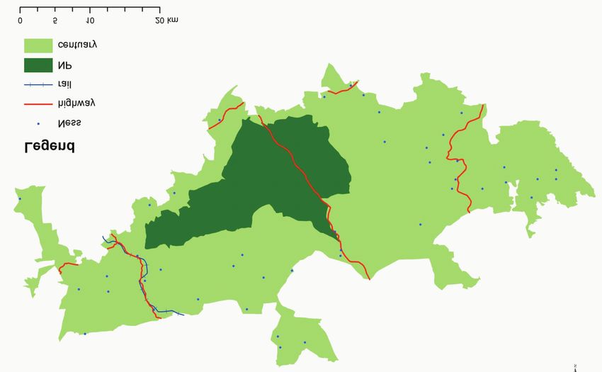
Assessment of Suitable Habitat of Near Threatened Striped Hyena (Hyaena hyaena Linnaeus, 1758) Using Remote Sensing and Geographic Information System

         (Cervus canadensis Erxleben 1777) whereas Hill and Kelly              shelter may also be contributing to the decline (Heptner and
         (1987) used it for kangaroo (Macropus giganteus Shaw                  Sludskij 1980). In the IUCN red list of threatened species,
         1790) habitat suitability assessment. Landsat image                   striped hyena is listed as ‘near threatened’. The striped hyena
         classifications were used in modelling for predicting the             occurs in low population densities throughout its distribution
         nesting sites of American kestrel, (Falco sparverius Linnaeus         range. Its habitats continue to shrink and fragment globally
         1758) (Lyon 1983). Harris (1983) used visual Landsat image            on account of an ever-increasing anthropogenic pressure.
         interpretation as an effective tool in re-introduction of the         Only few studies have been carried out on striped hyena
         white oryx (Oryx leucoryx Pallas 1766). In India, the use of          from Africa (Kruuk 1976; Leakey et al. 1999; Wagner 2006),
         geospatial technology for wildlife species habitat suitability        Israel (Bouskila 1984; Ilani 1975; Kerbis-Peterhans and
         analysis started during the late 1980s. Parihar et al. (1986)         Horwitz 1992; Skinner and Ilani 1979), and India (Davidar
         used remotely-sensed data from Landsat for habitat                    1990; Alam et al. 2009). There are large gaps in our
         evaluation of Indian one-horned rhinoceros (Rhinoceros                knowledge on several aspects of the striped hyena habitat
         unicornis Linnaeus 1758). Roy et al. (1995) used this                 relationship. The population dynamics and its habitat needs
         technology for habitat evaluation of mountain goat                    in particular are poorly understood. Being an important
         (Nemorhaedus goral Hardwicke 1825). Porwal et al. (1996)              member of the ecosystem, yet their population is globally
         used remote sensing data for evaluating the habitat for               declining (Hofer and Mills 1998; Akay et al. 2011) to the
         sambar (Cervus unicolor Kerr 1792), in Kanha National                 verge of extinction in several ranges (Kruuk 1976). The
         Park. Recently, Akay et al. (2011) used GIS and remote                striped hyena is considered as data deficient and threatened
         sensing technologies to monitor the local distribution of             animal in several areas of its geographical range (Hofer and
         striped hyena in Turkey. Potential habitat sites for 7 wildlife       Mills 1998). Hence, studies on this species are urgently
         species were identified by Mongkolswat and Thirangoon                 required not only to help in its survival, but also to further
         (1998) in north-east of Thailand. The geospatial technology           investigate its ecology and potential habitat for the long-term
         has been widely used since then for habitat suitability               conservation and survival. The striped hyena is one of the
         analysis of several wild animals viz., rhinoceros in                  least known large carnivore species that play an important
         Kazhiranga National Park (Kushwaha et al. 2000) and                   role in energy flow in an ecosystem. In many parts of
         mountain goat in Rajaji National Park (Kushwaha et al.                distribution ranges, its population has decreased and is
         2001). RS and GIS were used by Kalra (2005), Unial (2005)             presently confined to small patches. Among other reasons,
         and Habib et al. (2010) for the habitat evaluation of great           the habitat deterioration and depletion are the major factors,
         Indian bustard (Ardeotis nigriceps Vigors 1831), lion in              restricting the population of this species. The present study
         Kuno Sanctuary and ungulates in Pathri Rao watershed,                 demonstrates that extensive field work, sound database,
         respectively.                                                         statistical treatment of data and modelling which is helpful in
                                                                               predicting the potentiality of the habitat for striped hyena
         Striped hyena (Hyaena hyaena Linnaeus 1758) belongs to                with acceptable accuracy in one of the India’s successfully
         Hyaenaidae family, is one of the four extent species in the           managed protected area.
         world and the only species found in India. It is a scavenger in
         its habit (Prater 1971; Kruuk 1976; Boitani and and Bartoli           We used application binomial multiple logistic regression
         1986; Hofer 1998; MacDonald 1984) and distributed over                (BMLR) a statistical technique for predictive modeling
         North Africa, Arabia, Iraq, Iran, Afghanistan, Pakistan, and          (Hosmer and Lemeshow 2000) in this study. BMLR is quite
         India (Prater 1971; Kruuk 1976; Boitani and Bartoli 1986;             recent and widely used technique that has been used in
         Hofer and Mills 1998; MacDonald 1984; Alam et al. 2009).              several studies (Kushwaha et al. 2004; Singh 2004; Quadri
         Striped hyena occupies a range of habitats and may settle             2004; Braunisch et al. 2008; Zarri et al. 2008; Imam et al.
         wherever it gets sufficient food supply, adequate cover, and          2009; Singh and Kushwaha 2011).
         access to water (Kruuk 1976). It generally favors open or
         thorn bush areas in arid to semi-arid environments (Prater            2. Study Area
         1971; Rosevear 1974; Kruuk 1976; Rieger 1978; Leakey et
         al. 1999; Wagner 2006; Singh et al. 2010, Alam 2011) has              This study was carried out in the Gir National Park and
         been from Pine forest (Akay et al. 2011) where water is               Sanctuary (GNPS), located in Gujarat province of India
         available within 10 km (Rieger 1979). It favors large caves           (Figure 1). GNPS (20°40' to 21°50' N to 70°50' to 71°15' E)
         for resting (Kruuk 1976; Rieger 1979; Leakey et al. 1999)             lies around 40 km away from the coast in the Kathiawar or
         and avoids open desert and dense thickets and forests                 Saurashtra peninsula of the Gujarat state. It stretches over a
         (Rosevear 1974; Rieger1979; Heptner and Sludskii 1980).               length of about 70 km from west to east and 40 km from
         Rocky ridges are used for denning if area is hilly and                north to south. The maximum and minimum temperature is
         undulating (Kruuk 1976). Despite, striped hyena’s vast                45°C in summer and 7°C in winter. Rainfall is erratic and
         distribution, population is declining in many places due to           unevenly distributed. Maximum and minimum annual
         persecution and hunting, although hunting is prohibited               rainfall being 1866 mm and 199 mm, respectively average
         under Wildlife (Protection) Act, 1972. Factors such as                being 980 mm. There are 56 small temporary settlements of
         diminishing food stocks and competition with leopards over            Maldhari graziers locally known as Ness.

                                                                           2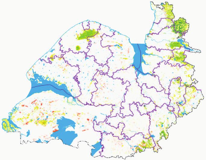
Asian Journal of Geoinformatics, Vol.14,No.2 (2014)

                                      Gujarat
                                                                                       India

                                 Ness
                                 Road
                                 Rail
                                 Gir National Park
                                 Gir Sanctuary
                                 Sanctuary

                             Figure 1. Location of Gir National Park and Sanctuary, Gujarat, India.

GNPS is well-known for the only wild population of Asiatic            GPS location of any direct or indirect evidence (pugmark,
lion (Panthera leo persica Meyer 1826). The total area of             kill, scats, den and feeding evidence) of wild animals was
GNPS is 1412.13 km² of which the National Park comprises              marked. Since, absence of a species cannot be considered as
of 258.71 km² surrounded by 1153.41 km² of sanctuary. It              being as certain as presence (Schroder and Richter, 2000),
also supports a rich biodiversity viz., 606 recorded flowering        wherever any direct or indirect evidences of a particular
plant species, 39 mammal species, 37 reptiles, more than 300          species were found, it was recorded “presence” for that
species of birds and around 2000 species of insects (Singh            particular species only and for other species “absence” was
and Kamboj 1996; Alam 2011). As per Champion and Seth                 marked.
(1968), the GNPS falls under type 5A/Cla, i.e., Very Dry
Teak Forest. The area is comprised of low hills of volcanic           Satellite data Landsat-TM with 30 meter spatial resolution
origin with an altitudinal range of 83-524 m above MSL.               was used (Figure 2). The digital elevation model (DEM) data
                                                                      of Shuttle Radar Topographic Machine (SRTM) was
3. Methodology                                                        downloaded from the website http://www.srtm.usgs.gov/,
                                                                      and imported to ERDAS Imagine 9.1 for producing aspect,
The study was carried out in three phases. In the first phase,        slope and elevation maps. A map of GNPS with various
field survey was carried out to collect data on the presence of       attributes with high resolution was procured and co-
striped hyena. Collection and processing of satellite and             registered using geometric correction techniques. All the
collateral data was done in second phase to create spatial            data were re-projected into Universe Transverse Mercator
database on forest type, forest canopy density, aspect, slope,        (UTM) World Geodetic System-84 (WGS 84) projection
elevation and distance attributes, whereas the geospatial             42N for further analysis.
modelling was carried out in last phase. In the present study
ERDAS Imagine 9.1, ArcGIS 9.3, ArcView 3.2a and SPSS-10               The forest cover and land use map (habitat map) of the study
computer softwares were used for image interpretation,                area was prepared through supervised digital classification
database creation and modelling.                                      of Landsat-TM data using Maximum Likelihood
                                                                      Classification (MLC) algorithm. Normalized difference
The field surveys were carried out from 2006 to 2010 to               vegetation index (NDVI) was used for preparation of forest
collect data on presence/absence of various wildlife species          canopy density map (Jensen 1986; Goward et al. 1991;
in GNPS. We adopted opportunistic sampling method and                 Gibson and Power 2000; Demers 2002; Lillesand and Kiffer
almost all the habitat types and forest areas of GNPS were            2002). The NDVI values were grouped into four forest
traversed on foot and wherever possible using a motor bike.           density classes viz.,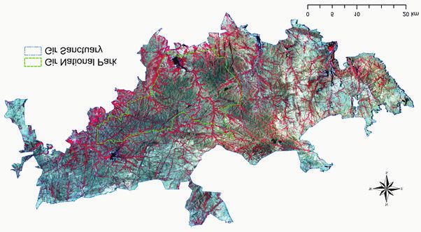
Assessment of Suitable Habitat of Near Threatened Striped Hyena (Hyaena hyaena Linnaeus, 1758) Using Remote Sensing and Geographic Information System

                                 Figure 2. Landsat-TM FCC of Gir National Park and Sanctuary, Gujarat, India.

                                 Topographic Map             SRTM DEM                 Satellite Data

                                      Distance from            Slope
                                        Drainage                                    Geometric Correction

                                                               Aspect
                                      Distance from
                                        Highway
                                                              Elevation                  Digital Image
                                                                                                                     Ground Truthing
                                                                                         Classification
                                  Distance from Tourism
                                          Road
                                                                           Forest Type              Forest Density
                                  Distance from Railway

                                      Distance from                                                                  Presence/Absence
                                                                                         Intersection
                                   Temporary Settlement                                                                    Data

                                                                                    BMLR Modelling
                                      Distance from
                                    Settlement Village

                                                                                    Assigning BMLR
                                   Distance from Water
                                                                                       Coefficient
                                          Point

                                                                               Hyena habitat suitability

                                           Figure 3. Striped hyena habitat suitability evaluation approach.

         70% (medium) and >70% (dense). Habitat suitability                    Values for forest type and forest canopy density were
         analysis requires generation of an accurate database on               recorded and specified as categorical variables. The points of
         various life support systems as well as potential disturbance         striped hyena detection were then intersected with all the
         factors affecting the habitat. Continuous surfaces of distance        input layers to produce the habitat use-environmental
         from drainage, tourism roads, state highways, railway, water          variables matrix. This worksheet was employed for further
         points, temporary settlements (ness) and settlement villages          statistical analysis. Striped hyena evidences (direct and
         were generated and co-registered for proximity analysis.              indirect) were taken as being present or absent of the species.
                                                                               The coefficients derived from BMLR were used to integrate
         GPS locations of striped hyena’s presence/absence were                all layers to arrive at the probability/suitability map. The
         imported to the GIS environment and attached as attributes            BMLR was used for analysis and coefficients mentioned in
         to all the locations. All the independent variables like slope,       Table 1 were considered as weight for the variables and then
         aspects and distance from drainage, tourism roads, state              inverse logit transformation was done to prepare probability
         highways, temporary settlements, settlement villages were             map for striped hyena (Figure 3).
         transferred into raster themes and used for further analysis.

                                                                           4
Asian Journal of Geoinformatics, Vol.14,No.2 (2014)
Table 1. Result of logistic regression analysis.
Table 1 Result of logistic regression analysis.
Variables B* SE Wald df Sig. Exp(B)
Aspect -0.002 0.002 1.058 1 0.304 0.980
Elevation -0.009 0.004 4.63 1 0.031 0.991
Slope -0.051 0.047 1.170 1 0.279 0.951
Distance to drainage -0.487 0.134 13.231 1 0.000 0.651
Distance to state highway 0.211 0.092 5.280 1 0.022 1.235
Distance to tourism road 0.212 0.077 7.548 1 0.006 1.236
Distance to railway -0.068 0.067 1.010 1 0.315 0.935
Distance to temporary settlement -0.271 0.191 2.011 1 0.156 0.763
Distance to settlement village 0.827 0.183 20.502 1 0.000 2.286
Distance to water point -0.195 0.115 2.862 1 0.091 0.823
Forest density (>10%) 1.229 1.088 1.275 1 0.259 3.418
Forest density (10-40%) 4.597 1.665 7.560 1 0.006 97.375
Forest density (40-70%) 2.170 1.222 3.151 1 0.076 8.756
Forest density (Assessment of Suitable Habitat of Near Threatened Striped Hyena (Hyaena hyaena Linnaeus, 1758) Using Remote Sensing and Geographic Information System
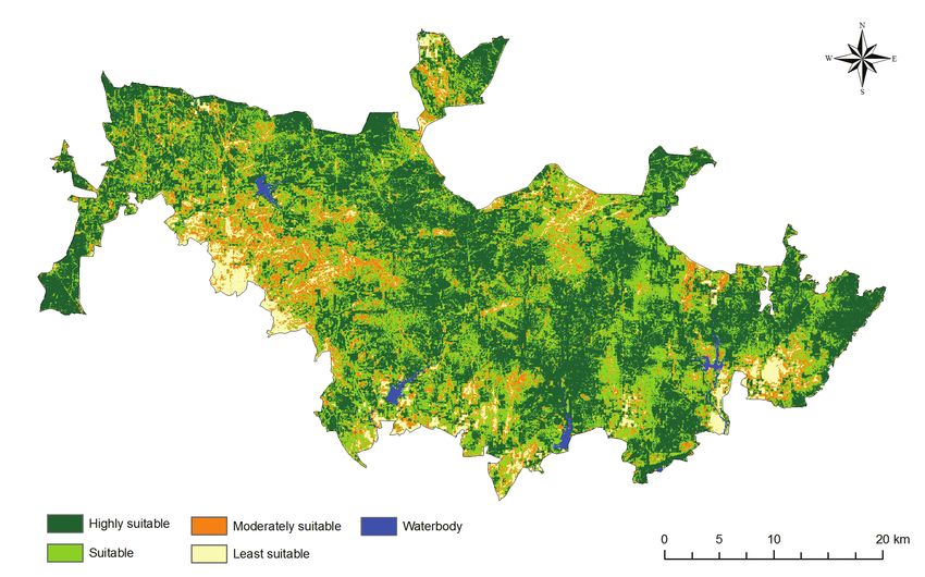
km²) suitable, 14.62% (206.51 km²) moderately suitable, Striped hyenas generally favour open or thorn bush country
whereas 6.87% (96.96 km²) is least suitable (Figure 5). in arid to semi-arid environments for denning, etc. (Rosevear
GNPS is one of the well-managed Protected Areas of India et al. 1974; Kruuk 1976; Prater 1971; Leakey et al. 1999;
which has not only excelled in Asiatic conservation (Meena Wagner 2006). Apart from this more nesses are there as
and Kumar 2012) but also supports other endangered fauna hyenas are found to survive on human refuse in landscapes
like leopard (Panthera pardus Linnaeus 1758) and hyena. other than this PA (Singh et al. 2010), more carcass
The suitable habitat for striped hyena in GNPS constitutes availability in these areas due to presence of large predators
about 78.51% that depicts the well management and in good numbers (Meena and Kumar 2012).
conservation of this protected area as despite of having good
number of top predators. The habitats which are highly Population estimate of striped hyena using photographic
suitable for the hyena are spread in the eastern parts of the capture-recapture in GNPS (Alam 2011) also supports this
GNPS except the National Park which lies in the centre. This habitat suitability model with respect to distribution of the
is probably due to favourable habitat condition that is low species. Population density was found higher in eastern part
tree density and high grass cover in eastern part as compare as compared to the central and western part of the GNPS
to national park and western sanctuary as correlated between (Alam 2011). Other reason could be due to high density of
the hyena population and habitat of GNPS (Alam 2011). natural predators such as lions and leopards in eastern part,
Table
Table 3. Different
3 Different habitat
habitat types types
in Gir in Gir National
National Park andPark and Sanctuary.
Sanctuary.
Habitat/Forest Type Area in km² Percentage area
Riveraine Forest 367.15 9.92
Moist Mixed Forest 187.85 26.00
Tectona/Anogeissus-Acacia-Ziziphus 104.07 17.38
Acacia-Tectona/Anogeissus 1.38 25.22
Acacia-Lannea-Boswellia 245.47 7.37
Thorn Forest 356.09 13.30
Agriculture 10.03 0.10
Waterbody 140.09 0.71
Figure 5. Potential habitat map of striped hyena in Gir National Park and Sanctuary.
6Asian Journal of Geoinformatics, Vol.14,No.2 (2014)
compared to western part of the park, provide more kills for Forest Department for permission to work in Gir National
the natural scavengers like striped hyena (Alam 2011). Park and Sanctuary. Authors also thank to Dr. P.S. Roy,
Striped hyenas are reported to be found near the human Dean, Indian Institute of Remote Sensing, ISRO, for kind
habitations (Prater 1971; Kruuk 1976; Hofer and Mills 1998, support. We would like to express sincere thanks to Deputy
Singh et al. 2010; Akay et al. 2011; Alam 2011), where they Conservator of Forests Mr. S. Maniswar Raja, for help and
occasionally feed on human food leftovers and carcass of support during the field work. We are thankful to Dr. Azra
livestock. In GNPS, majority of temporary settlements and Musavi for going through the manuscript. We also
villages are located in the eastern part and less in western acknowledge two anonymous reviewers for their valuable
part whereas there is no human settlement in the National comments and suggestions to improve this manuscript. Dost
Park area. The analysis suggested that besides other factors, Mohammad, Suresh, Sagar and Sabdad field assistants, and
forest type- Acacia-Tectona/Anogeissus, forest density (10- many Gir forest staffs are thanked for help in the field.
40%), drainage, water points have played important role in
governing the habitat suitability index.
The forest canopy density of GNPS is fairly good for animals
like striped hyena in GNPS as this species is known to prefer References
open thorn forest (Prater 1971; Rosevear 1974; Kruuk 1976;
Rieger 1978; Leakey et al. 1999; Wagner 2006; Singh et al. Akay A.E., Inac S. and Yildrim I.C. (2011) Monitoring the
2010; Alam, 2011). Approximately 9.16% of forest area is local distribution of striped hyenas (Hyaena hyaena L.) in
covered by canopy density of more than 70%, while 26.73% the Eastern Mediterranean Region of Turkey (Hatay) by
with the density class of 40–70%, 49.96% with the density using GIS and remote sensing technologies. Environ
class of 10-40% and 13.60% with the density class of less Monit Assess, 181, 445-455.
than 10% (Alam et al. 2014). Availability of 63.56 % area as
Alam M.S., Khan J.A. and Pathak B.J. (2009) Status ecology
open and thorn forest support the striped hyena habitat
and conservation of striped hyena (Hyaena hyaena) in Gir
suitability model while high forest density made the National
National Park & Sanctuary. Project Technical Report,
Park area for the striped hyena moderately suitable. Moist
Wildlife Society of India, Aligarh, India.
forest areas also play important role in ecology of big
carnivores in GNPS. Asiatic lions and leopards take shelter Alam M.S. (2011) Status ecology and conservation of striped
in these areas and make most of their prey kills (Meena and hyena (Hyaena hyaena) in Gir National Park and
Kumar 2012). These prey kills provide enough food supply Sanctuary, Gujarat. Ph.D. Thesis, Aligarh Muslim
in the form of carcass for the species like striped hyena University, Aligarh, India.
(Alam 2011) that leads movement of this species in moist
forest of GNPS in search of food. GNPS falls under semi- Alam, M.S., Khan J.A., Pathak B.J. and Kumar S. (2014)
arid zone of Gujarat state in India, having open and thorn Assessment of forest density using geospatial techniques
forests that provide favorable resources and safe denning of a tropical protected area. International Journal of
refuge for striped hyena. Scientific and Research Publications, Volume 4, Issue 3,
March 2014.
It is crucial to evaluate the habitat of striped hyena to ensure
the continuity of distribution whose population is tend to Boitani L. and Bartoli S. (1986) The MacDonald
decrease in many parts of its natural distribution areas. The Encyclopedia of Mammals. Mac Donald & Co. Ltd,
result from this study suggests that GIS and remote sensing London.
technologies can be used to evaluate the distribution of such
a rare and difficult to monitor species in cost effective Bouskila Y. (1984) The foraging groups of the striped hyena
manner with high accuracy level. Here, habitat suitability (Hyaena hyaena syriaca). Carnivore, 7, 2-12.
modelling accurately predicted striped hyena habitat with
respect to density in GNPS. The model output can easily be Braunisch C., Bullmann K., Graf R.F. and Hirzel A.H. (2008)
interpreted by experts and managers, having thereby a great Living on the edge: modeling habitat suitability for
practical importance and would serve as baseline for future species at the edge of their fundamental niche. Ecol.
management planning for the conservation of the species. Model., 214 (2–4), 153–167.
The availability of fair percentage of suitable habitat is
encouraging and indicates that the GNPS could serve as Bright L.R. (1984) Assessment of elk habitat for resource
important conservation area for protecting this near management and planning activities from Landsat
threatened carnivore species in India. mapping products. In: Renewable Resources Management.
American Society of Photogrammetry and Remote
Acknowledgements Sensing, Falls Church,Virginia, pp. 101–108.
We are thankful to Ministry of Environment and Forests, Champion H.G. and Seth S.K. (1968) A revised survey of the
Government of India for the financial support and Gujarat forest types of India. Manager of Publication, Government
7Assessment of Suitable Habitat of Near Threatened Striped Hyena (Hyaena hyaena Linnaeus, 1758) Using Remote Sensing and Geographic Information System
of India, New Delhi. Conservation Action Plan of Hyaena. IUCN/SSC.
Information Press, Oxford.
Davidar E.R.C. (1990) Observation at a hyena, Hyaena
hyaena Linn. Den. Journal Bombay Natural History Hofer H. and Mill G. (1998) Worldwide distribution of
Society, 87, 445-447. hyena. Status Survey & Conservation Action Plane of
Hyena, IUCN/SSC. Information Press, Oxford, pp. 44-53.
Davis F.W., Stoms D.M., Estates J.E., Scepan J. and Scott
J.M. (1990) An information system approach to Hosmer and Lemeshow (2000) Applied Logistic Regression,
preservation of biological diversity. Int. J. Geog. Inf. 2nd Edition. New York; Wiley.
Syst., 4,55–78.
Illani G. (1975) Hyenas in Israel. Israel-Land and Nature,
Demers M.N. (2002) Fundamentals of Geographic 16, 10-18.
Information Systems. Second Edition. Jhon Wiley and
Sons, Inc. Imam E., Kushwaha S.P.S. and Singh A. (2009) Evaluation
of suitable tiger habitat in Chandoli National Park, India,
ESRI (1999) ArcView 3.2a User Manual. Environmental using multiple logistic regression. Ecol. Model. 220,
Systems Research Institute, Inc., Redlands, CA, USA. 3621-3629.
ESRI (2008) ArcGIS 9.3 User Manual. 380 New York Street, Jensen J.R. (1986) Introductory digital image processing: A
Redlands, CA 92373-8100, USA. remote sensing perspective. Prentice-Hall, Englewood
Cliffs, New Jersey.
Fielding A.H. and Bell J.F. (1997) A review of methods for
the assessment of prediction errors in conservation/ Kalra M. (2005) Habitat suitability analysis of great Indian
presence absence models. Environ. Conserv. 24, 38–49. bustard in Thar desert using remote sensing and GIS.
Dissertation, Indian Institute of Remote Sensing (NRSA,
Gibson P.J. and Power C.H. (2000) Introductory Remote ISRO), Dehradun.
Sensing Digital Image Processing and Applications.
Routledge, London Kerbis-Peterhans J.C. and Horwitz L.K. (1992) A bone
assemblage from striped hyena (Hyaena hyaena) den in
Goward S.N., Markham B., Dye D.G., Dulaney W. and Yang the Negev Desert, Israel. Israel Journal of Zoology, 37,
J. (1991) Normalized difference vegetation index 225-245.
measurements from the Advanced Very High Resolution
Radiometer. Remote Sensing of the Environment, v. 35, p. Kruuk H. (1976) Feeding and social behavior of the striped
257-277. hyena (Hyaena hyaena), E.Afr. Wildl. J.,14, 91-111.
Guisan A. and Zimmermann N.E. (2000) Predictive habitat Kushwaha S.P.S., Roy P.S., Azeem A., Boruah P. and Lahan
distribution models in ecology. Ecol. Model., 135, 147– P. (2000) Land area change and rhino habitat suitability
186. analysis in Kaziranga National Park, Assam. Tiger paper,
27, 9–17.
Habib B., Dar T.A., Khan J.A. and Kushwaha S.P.S. (2010)
Evaluation of habitat suitability models for four sympatric Kushwaha S.P.S., Munkhtuya S. and Roy P.S. ( 2001)
ungulate species in Pathri Rao Watershed adopting Mountain goat habitat evaluation in Rajaji National Park
geostatistical modelling. CurrSci, 99(4), 500-506. using remote sensing and GIS. J. Indian Society of Remote
Sensing, 28, 293-303.
Haptner V.G. and Sludskij A.A. (1980) Die Saugetiere der
Sowjenmion (Vol. III) In, Mill G, Hofer H. (1998) Status Kushwaha S.P.S. (2002) Geoinformatics for wildlife habitat
Survey & Conservation Action Plane of Hyena, IUCN/ characterization, Proceedings of Map India, 5th Annual
SSC. Information Press, Oxford, pp. 44-53. International Conference, New Delhi.
Harris R. (1983) Remote sensing support for the Omani Kushwaha S.P.S., Khan A., Habib B., Quadri, A. and Singh
white Oryx project. Proc. of Conference on the Application A. (2004) Evaluation of sambar and muntjac habitats
of Remote Sensing Techniques to Aid Range Management, using geostatistical modelling. Curr. Sci. 86(10), 390–
Silsoe, 17–24. 1400.
Hill G.J.E. and Kelly G.D. (1987) Habitat mapping by Leakey L.N., Milledege S.A.H., Leakey S.M., Haynes P.,
Landsat for aerial census of kangaroos. Remote Sensing Kiptoo D.K. and McGeorge A. (1999) Diet of striped
Environ., 21, 53–60. hyaena in Northern Kenya. African Journal of Ecology,
34, 314-326.
Hofer H. (1998) Species Accounts, Status survey &
8Asian Journal of Geoinformatics, Vol.14,No.2 (2014)
Lecis R. and Norris K. (2003) Habitat correlates of Zoo. Carnivore. 1(2), 49-60. In, Mill, G. and Hofer, H.
distribution and local population decline of the endemic 1998. Status Survey & Conservation Action Plane of
Sardinian new Euproctus platycephalus. Biol. Conserv., Hyena, IUCN/SSC. Information Press, Oxford, 44-53.
115, 303–317.
Riger I. (1979) A review of biology of striped hyena (Linne
Leica Geosystems (2008) ERDAS IMAGINE 9.2 User 1758). In: Mill, G. and Hofer, H. 1998. Status Survey and
Manual, GIS and Mapping. gis.leicageosystems.com, Conservation Action Plane of Hyena, IUCN/SSC.
accessed on 21st October, 2011. Information Press, Oxford, 44-53.
Lillesand T.M. and Kiefer R.W. (2002) Remote Sensing and Rosevear D.R. (1974) Carnivores of West Africa. British
Image Interpretation. Fourth edition. John Willyand Sons, Museum of Natural History, London. in Mill, G. and
Inc., New York, 586, pp. Hofer, H. 1998. Status Survey & Conservation Action
Plane of Hyena, IUCN/SSC. Information Press, Oxford,
Lyon J.G. (1983) Landsat derived land cover classifications 44-53.
for locating potential kestrel nesting habitat. Photogramm.
Engg. Remote Sensing 49, 245–250. Roy P.S., Ravan S.A., Rajadnya N., Das K.K., Jain A. and
Singh S. (1995) Habitat suitability analysis of
Macdonald D. (1984) The Encyclopedia of Mammals, Nemorhaedus goral- a remote sensing and geographic
Greenwich Editions, London, pp. 154-159. information system approach. Curr. Sci., 69, 685–691.
Meena R.L. and Kumar S. (2012) Management Plan for Gir Schamberger M. and Krohn W.B. (1982) Status of the habitat
Protected Areas, Vol-1; Gujarat Forest Department, evaluation procedures. Trans. North Am. Wildl. Nat.
Gujarat, India Resour. Conf., 47, 154–164.
Mongkolswat C. and Thirangoon P. (1998) Application of Schroder B. and Richter O. (2000) Are habitat models
satellite imagery and GIS to wildlife habitat suitability transferable in space and time? J. Nat. Conserv, 8,195–
mapping. AARS-ACRS1998, www.gisdevelopment.net/. 205.
Assessed on 21st October, 2011.
Singh A. (2004) Wildlife habitat analysis and vulnerability
Osborne P.E., Olonso J.C. and Bryant R.G. (2001) Modelling assessment of the Binsar wildlife sanctuary, Uttaranchal.
landscape-scale habitat use using GIS and remote sensing: P.G Diploma Dissertation, Indian Institute of Remote
a case study with Great Bustard. J. Appl. Ecol., 38,458– Sensing, Dehradun, India.
471.
Singh A and Kushwaha S.P.S. (2011) Refining logistic
Parihar J.S. and Panigrahy S. (1986) Remote sensing based regression models for wildlife habitat suitability modelling
habitat assessment of Kaziranga National Park. In: Kamat - a case study with muntjak and goral in the Central
D.S. and Panwar H.S. (Eds.) Wildlife habitat evaluation Himalayas, India. Ecol. Model, 222(8), 1354-1366.
using remote sensing techniques. Indian Institute of
Remote Sensing/Wildlife Institute of India, Dehra Dun, Singh P., Gopalaswamy A.M. and Karanth K.U. (2010)
pp. 157–164. Factors influencing densities of striped hyenas (Hyaena
hyaena) in arid regions of India. Journal of Mammology,
Pearce J. and Ferrier S. (2000) Evaluating the predictive 91(5), 1152-1159.
performance of habitat models developed using logistic
regression. Ecol. Model., 133, 225–245. Singh H.S. and Kamboj R.D. (1996) Biodiversity
Conservation Plane for Gir (Vol.-I), Forest Department
Porwal M.C., Roy P.S. and Chellamuthu V. (1996) Wildlife Gujarat state, Gandhinagar.
habitat analysis for sambar (Cervus unicolor) in Kanha
National Park using remote sensing. Int. J. RemoteSensing Skinner J.D. and Illani G. (1979) The striped hyaena, Hyaena
17, 2683–2697. hyaena, in the Judean and Negv Desert and a comparison
with the brown hyaena, Hyaena brunnea. Israel Journal
Prater S.H. (1971) The Book of Indian Animals. Bombay of Zoology, 28, 229-232.
Natural History Society. Oxford University Press,
Bombay. SPSS 10(1988) SPSS-X User’s Guide, 3rd ed. SPSS Inc.,
Chicago.
Quadri A. (2004) Tiger habitat analysis in Corbett Tiger
Reserve using remote sensing and GIS. Project Report, Unial D.P. (2005) Habitat suitability analysis of lion in
Indian Institute of Remote Sensing, Dehradun. proposed Palpur Kuno Sanctuary using remote sensing
and GIS. Dissertation, Indian Institute of Remote Sensing,
Riger I. (1978) Social behavior of the striped hyena at Zurich Dehradun.
9Assessment of Suitable Habitat of Near Threatened Striped Hyena (Hyaena hyaena Linnaeus, 1758) Using Remote Sensing and Geographic Information System
US Fish and Wildlife Service (1981) Standards for the University, Bozeman, Montana.
development of habitat suitability models for use in the
habitat evaluation procedures. USDIFWS, ESM 103, Zarri A.A., Rahmani A.R., Singh A. and Kushwaha S.P.S.
Washington, DC. (2008) Habitat suitability assessment for the endangered
Nilgiri Laughing Thrush: a multiple logistic regression
Wagner A.P. (2006) Behavioral Ecology of Striped hyena approach. Curr. Sci. 94 (11), 1487–1494.
(Hyaena hyaena). Ph.D. Dissertation, Montana State
10You can also read