BELIZE'S HEALTH SECTOR: DENGUE AND DENGUE HEMORRHAGIC FEVER - Assessment of the Impact of CLIMATE CHANGE On BELIZE SECOND NATIONAL COMMUNICATION ...
←
→
Page content transcription
If your browser does not render page correctly, please read the page content below
Assessment of the
       Impact of CLIMATE CHANGE
                    On
       BELIZE’S HEALTH SECTOR:
DENGUE AND DENGUE HEMORRHAGIC FEVER

  BELIZE SECOND NATIONAL COMMUNICATION (SNC) PROJECT

                    Dr. Errol Vanzie

                     November, 2008

                                                       1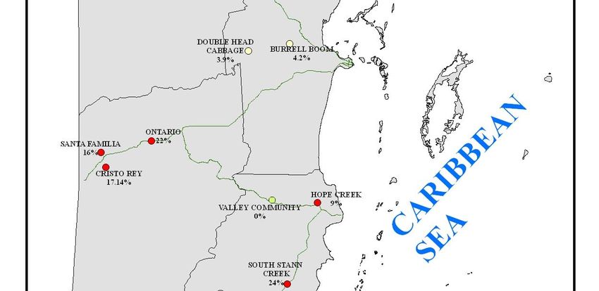
TABLE OF CONTENTS

ACRONYMS                                             4
LIST OF FIGURES AND MAPS                             5
LIST OF TABLES                                       5
EXECUTIVE SUMMARY                                    6
COUNTRY PROFILE                                     10
      Demographic Characteristics                   10
      Population                                    10
      Climate                                       11
      Topography                                    13
      Economy                                       14
      Ministry Of Health Budget                     15
      Poverty                                       17
      Labour Force                                  17
      Health Care System                            17
      Programmatic Areas                            18
CLIMATE CHANGE VULNERABILITY AND ADAPTATION
ASSESSMENT OF DENGUE AND DENGUE HEMORRHAGIC FEVER
IN BELIZE                                           19
      Background                                    19
              Objectives Of The Assessment          20
              Terms Of Reference                    20
              Scope Of The Assessment               20
              Risk Assessment                       21
              Duration Of Study                     21
              Deliverables                          21
              Methodology                           21
              Data Acquisition And Compilation      22
      Entomological Cross-sectional Survey          23
              Objectives of the Survey              23
              Methodology                           23
              Target Population                     23
              Study Population                      23
              Sampling Process                      23
              Sample Size                           23
              Data Collection Procedure             24
              Data Collection Instrument            24
              Statistical Analysis                  24
      Selection Of Scenarios                        25
      Project Timeframe                             25
      Disease Selection                             25
      Impact Assessment                             26
      Adaptation Assessment                         26
      Project Output                                26
              Clinical Dengue                       26

                                                         2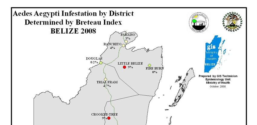
Epidemiology of Dengue        27
             Distribution of Dengue        27
             Risk factors                  27
             Vector                        27
             Environmental                 29
             Socioeconomic                 30
             Control Measures              30
             The Global Burden of Dengue   30
ASSESSMENT OF PRESENT VULNERABILITY AND
ADAPTATION CAPABILITIES                    32
      Dengue Distribution                  34
      Seasonal Variation                   35
      Vectors                              37
      Socioeconomic Factors                38
      Poverty                              39
      Environmental Factors                39
      Response Capacity                    40
VULNERABILITY                              40
THEORETICAL FRAMEWORK FOR CLIMATE CHANGE
IMPACT ON HEALTH                           41
ASSESSMENT OF FUTURE VULNERABILITY         42
      Hazard Definition                    42
      Risk Estimation                      42
      The Hazard                           44
      Evaluation of Risk                   45
      Adaptation and Risk Control          47
FINDINGS                                   50
CONCLUSIONS                                51
RECOMMENDATIONS                            52
ANNEXES                                    54
BIBLIOGRAPHY                               69

                                                3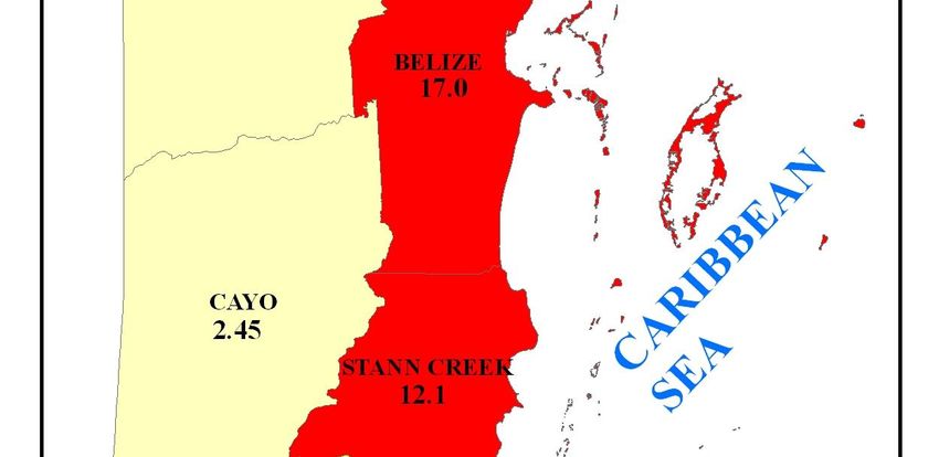
ACRONYMS

BI       Breteau Index
BTA      Belize Tourism Association
CAREC    Caribbean Epidemiology Center
CCCCC    Caribbean Community Climate Change Center
CI       Container Index
DALY     Disability Adjusted Life Years
DF       Dengue Fever
DHF      Dengue Hemorrhagic Fever
DSS      Dengue Shock Syndrome
ENSO     El Niño Southern Oscillation
EU       European Union
FHS      Family Health Survey
GDP      Gross Domestic Product
GHG      Green House Gas
HI       House Index
IPCC     Intergovernmental Panel on Climate Change
MOH      Ministry of Health
NAI      Non Annex One
NCSP     National Communications Support Programme
NHI      National Health Insurance
NMS      National Meteorology Services
PAHO     Pan American Health Organization
SNC      Second National Communication
SRES     Emission Scenarios
SSB      Social Security Board
TAR      Third Assessment Report
UNFCCC   United Nation Framework Convention on Climate Change
WHO      World Health Organization
WMO      World Meteorology Organization

                                                                4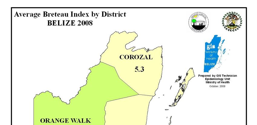
LIST OF FIGURES & MAPS

Figure 1: Monthly Temperature, Belmopan                                     12
Figure 2: Spatial distribution of annual average rainfall in Belize         12
Figure 3: Belize topography                                                 14
Figure 4: World Distribution of Dengue                                      28
Figure 5: Dengue Trend 2000-2007                                            33
Figure 6: Age distribution of dengue, 2007                                  34
Figure 7: Dengue cases by gender, 2007                                      34
Figure 8: Seasonal Variation of Dengue in Belize                            35
Figure 9: Seasonal Variation between Dengue and Rainfall                    36
Figure 10: Incident/Cases of Dengue by Month-2007                           36

Annex E: 1E- Aedes aegypti by district, Belize 2008-map                     64
Annex E: 2E- Average Breteau Index by district, Belize 2008-map             65
Annex E: 3E- Dengue risk by district, Belize 2007-map                       66
Annex F: F1-Number of wet days, Tower Hill                                  67
Annex F: F2-Maximum of consecutive dry days, Tower Hill                     67
Annex F: F3-Maximum number of consecutive wet days, Tower Hill              67

                                        LIST OF TABLES

Table 1: Inflation rate, 2003-2007                                          15
Table 2: MOH Budget, 2001-2007                                              16
Table 3: Trend in per capita allocation                                     16
Table 4: Main labour force indicators, 2003-2004                            17
Table 5: Entomological Indices by district and village, 2008                24
Table 6: Dengue cases per year                                              32
Table 7: Dengue Serotype Emergence                                          33

Annex A: 1A Hazard frequency/Probability Rating                             54
Annex A: 2A-9A Direct Impact Rating                                         58
Annex B: 1B-7B Risk Assessment Matrix                                       58
Annex B: 8B Risk Assessment Keys (codes)                                    61
Annex C: 1C - Entomological Indices by district and village, Belize 2008    63
Annex D: 1D- Type of containers and Productivity by district, Belize 2008   64

                                                                                 5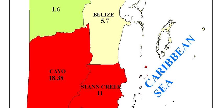
EXECUTIVE SUMMARY
Belize, like many other Non-Annex One (NA1) Parties to the United Nations Framework
Convention on Climate Change (UNFCCC) has been preparing its Second National
Communications, in partial fulfillment of its obligation to implement the Convention as
stipulated in Articles 4.1 and 12 of the Convention (United Nations, 1992).
It was decided to conduct a Vulnerability and Adaptation of the Health Sector since this was one
of the sectors not addressed in the First National Communication report.
Since dengue is considered to be a climate sensitive disease which is endemic in Belize; that the
potential for DHF to occur is likely, and also due to the concern over recent outbreaks of dengue
in South and Central America, the Ministry of Health deem it opportune at this time to conduct a
vulnerability and adaptation assessment on climate change and dengue, in order to determine the
present and future level of risk, the present adaptive capacity and required adaptation measures
to minimize future impact of this disease.
Dengue is the most important arboviral disease of humans, occurring in tropical and subtropical
regions worldwide. In recent decades, dengue has become an increasing urban health problem in
tropical countries. The disease is thought to have spread mainly as a result of ineffective vector
and disease surveillance; inadequate public health infrastructure; population growth; unplanned
and uncontrolled urbanization; and increase national and international travel. The main vector of
dengue is the domesticated mosquito, Aedes aegypti, which breeds in urban environment in
artificial containers that hold water. Dengue also can be transmitted by Aedes albopictus, which
can tolerate colder temperatures.
Dengue is seasonal and usually associated with warmer, more humid weather. There is evidence
that increased rainfall, humidity and temperature can affect the life cycle of the vector and virus,
thus increasing the transmission potential.
The main goal of this assessment is to determine the present and future occurrence of dengue and
DHF and to measure its impact on the health care system and the population in terms of
morbidity and mortality, also to measure the socio-economic impact of adaptation measures.
More specifically, the objectives were:
Describe the present level of risk for dengue and DHF in Belize
Project the future occurrence of dengue based on present risk levels and expected
population growth, in the absence of climate change.
Utilizing selected socioeconomic and climatic scenario, project the future impact of
dengue and DHF in Belize.
Recommend adaptation strategies to cope with potential impact.
The method used was determined after consultation with senior staff of the National
Meteorological Service, the Statistical Institute of Belize, the Ministry of Health and the Vector
Control Program, in order to assess existing modeling capability and the availability of data.
6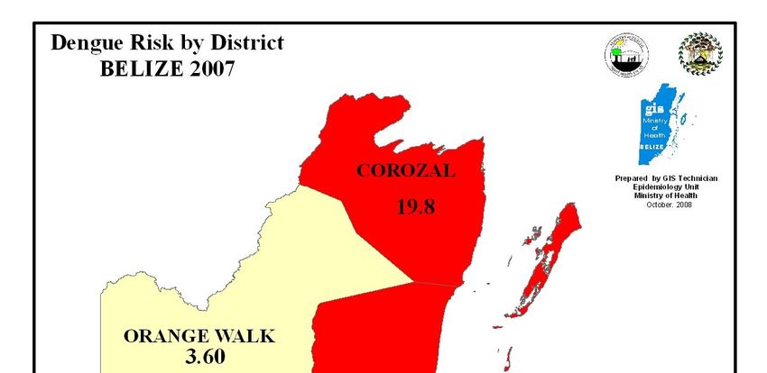
Since no modeling studies have been conducted in Belize, linking the occurrence of dengue to
socio-economic, climatic or environmental factors, and since the available data does not allow
for modeling (multiple regression analysis) to predict changes in the dependent variable
(incidence of dengue) for unit change in the independent variables (climate parameters and
others). The decision was made not to attempt the prediction of impact through mathematical
modeling, but to use risk assessment to determine vulnerability.

Hence, the method use was the “Bottom-up, Risk-Based Hazard assessment framework”
combined with the “Top-down” approach to conduct the vulnerability and adaptation assessment.
Under this model, the climatic, socio-economic and environmental drivers of dengue are
identified; present risk (vulnerability) of dengue and adaptation capability of the country is
described based on historic and current data. Utilizing the risk management process, taking into
account future climate scenarios, and expert judgment, determination is made as to how the
projected climate changes will impact on dengue and what proactive adaptation measures needs
to be implemented in order to reduce vulnerability and minimize impact.

Belize has determined that the A2 Emission Scenario best describes its future path to
development. Under this scenario, Belize is described as a very heterogeneous country. The
underlying theme is self-reliance and preservation of local identities. Fertility patterns across the
country converge very slowly, which results in high population growth. Economic development
is primarily locally oriented and per capita economic growth and technological change
fragmented and slow.

The time period (time horizon) over which projections was made, took into account the limits of
predictability. The projected Climatic scenarios therefore were made for the decades of the
2020’s and 2050’s.

Present vulnerability was determined by the presence of the Aedes Aegypti mosquito, any of the
4 virus serotypes capable of producing dengue, and socioeconomic and environmental factors.

The review of data related to the occurrence of dengue in the period 1995-2007 reveal that low
levels of dengue transmission has been consistently occurring in all districts during this period.
The trend is toward the increase and all virus serotypes have been isolated. The risk to the
population as determined by the 2007 incidence was 0.00106 with the Corozal District exhibiting
the highest risk. Data from different years consistently show June to November as the period of
highest occurrence. There is a strong correlation (Pearson Product Moment “r” of 0.758)
between dengue seasonal variation and monthly average rainfall.

An entomological cross-sectional survey conducted during the month of August 2008 revealed
the presence of the virus in all districts. The vector density as determined using the Breteau and
other entomological indices is high, requiring urgent attention. 17% of surveyed communities
had a Breteau Index below 2%. This is the threshold (even though disputed) below which dengue
transmission is unlikely. Thirty nine (39) percent had Breteau Indexes between 2 and 5 per cent;
this level of larvae infestation supports the maintenance of endemic dengue and low level
outbreaks. Eight communities (44%) had larvae infestation as determined by the Breteau Index,
between 6 and 24 per cent; the probability of dengue outbreak is very high in these communities.

                                                                                                   7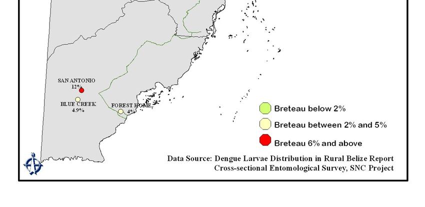
The temperature, humidity, rainfall, and altitude above sea level in Belize are within the values,
conducive to the sustainable transmission of dengue. Taking into consideration the status of the
environmental, biological and socioeconomic factors in Belize, and also the present adaptation
capacity, the country has been categorized as having a “medium level vulnerability”.
Following the risk management process, risk scenarios were developed depicting ways in which
dengue (the hazard) could affect different sectors of society, in order to identify dengue risk
events. Using standardized Direct Impact Rating tables, Frequency/Probability Rating tables and
the Risk Assessment Matrix table, each dengue risk event was ranked as follow:-
Increased cost of health care delivery extreme risk
Increased cost of outbreak control extreme risk
Work absenteeism high risk
Personal income loss high risk
Reduced national production moderate risk
School absenteeism moderate risk
Cancelled tourist visits moderate risk
This ranking was achieved taking into consideration how each dengue risk event affects different
sectors: the loss involved, the cost of control, and the value placed on the impact of each event
by stakeholders.
1) Extreme Risk: This indicates an unacceptable level of risk that requires immediate
control to move the activity out of extreme range
2) High Risk: This level will require high priority control measures to reduce risk
to an acceptable level
3) Moderate Risk: Some controls will be required to move this risk scenario to lower levels
Adaptation measures recommended below, were based on what was considered to be the most
cost effective control strategies, to address the potential impacts and which are consider to be
acceptable to stakeholders.
Improve national diagnostic capability and dengue management, especially for DHF/FSS.
Implement an effective, sustainable, community based vector control program.
Elicit the educational system to incorporate dengue prevention in the natural science
curricula.
Incorporate environmental sanitation as a permanent topic in schools’ PTA agenda.
Enforce the environmental and public health laws.
Promote and reinforce changes in human behavior through health communication and
health promotion strategies, which include specific target audiences from the school
curricula to mass media participation, among others, to reach most of the population and
affect the society as a whole.
Promote and strengthen entomological surveillance capability at the local level, to
determine Aedes aegypti distribution and level of infestation, to detect areas of new
infestation, and to support local level societies in taking necessary actions to prevent
further spread of the mosquito.
8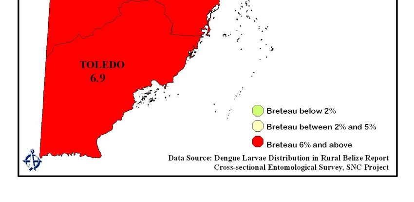
Strengthen the epidemiological surveillance system for early detection of dengue cases and rapid
implementation of transmission control measures to reduce transmission and prevent the
occurrence of epidemics.
Train and equip regional rapid response teams for the control of dengue epidemics.
Encourage employers to insure employees with SSB for employment benefits and with
private and public (NHI) health insurance companies in order to guarantee health care to
employees.
Encourage the self employed worker to make use of the SSB “voluntary contribution
program” and to seek health insurance coverage in the private or public health (NHI)
sectors.
Encourage the tourism industry and Public Health to do the following: a) incorporate
good environmental sanitation practices into the existing requirements for hotel
accreditation. b) Attach to the tourism tax funds that municipalities receive at present,
requirements for proper sanitary control of parks, cemeteries, drainage and empty house
lots.
The vulnerability and adaptation assessment exercise has concluded that, dengue is endemic in
Belize; that four (4) serotypes of dengue viruses have circulated in the country; that medium
level risk of dengue outbreaks exist, particularly DHF; that present entomological indices are
unacceptable, requiring immediate action; that the projected increase in extreme events will
exacerbate the potential for major outbreaks of dengue to occur in the future; that information to
monitor implementation of control measures and to assess impact on risk reduction and disease
occurrence, is inadequate; and that the implementation of a community based vector control
program will be more sustainable and cost-effective than the centralized chemical based control
strategy .
9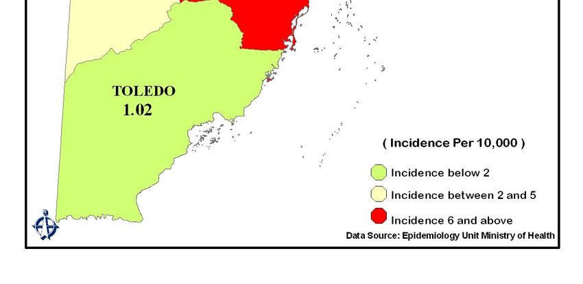
COUNTRY PROFILE

Belize is located in Central America lying in the outer tropics or subtropical geographic belt. It is
bordered by Mexico to the north, Guatemala to the west and south and by the Caribbean Sea to
the east. The geographic coordinates are 15.45 and 18.30 North Latitude and 87.30 and 89.15
West Longitude. Belize is 274 km (170 miles) long and is 109 km (68 miles) wide. The total
land area is 22,700 km2 (8,867 square miles). The climate is subtropical, very hot and humid,
with a rainy season (middle of May to November) and a dry season (February to May) separated
by a cool transitional period (November to February). The prevailing winds are easterly/north
easterly trade winds generated by Bermuda subtropical high. The temperature ranges between
of 75°F and 90°F. The average rainfall is 60 inches (1,500mm). In relation to elevation
extremes the lowest point is the coastal area (0 m) and the highest point is the Doyle’s Delight
(≈1,164m). The population density was approximately 31 inhabitants per square mile in the year
2003. A former British colony, Belize is the only English-speaking country in Central America.
It is more similar to other English–speaking Caribbean countries in culture, politics, and
economy; however, due to its location Spanish is widely spoken.

Belize obtained its independence from Britain in 1981. It is a sovereign state governed by the
principles of parliamentary democracy based on the British Westminster system. The titular head
of state is Queen Elizabeth II, represented by a Governor General. A Prime Minister and Cabinet
constitute the executive branch of the government while a thirty-one member elected House of
Representatives and a nine-member appointed Senate form a bicameral legislature, the National
Assembly.

In 1971 the capital was moved from Belize City to Belmopan because Belize City was destroyed
twice by hurricanes. The country has six administrative districts: Corozal, Orange Walk, Belize,
Cayo, Stann Creek and Toledo. Each urban area is administered by a locally elected town board,
which is comprised of seven members. Unique to this system is Belize City, which has its own
nine-member elected City Council. Village Councils assist in village level administration with
the traditional “Alcaldes” or mayoral system of the south (Toledo District) incorporated into the
structure. Districts are further subdivided into villages and government is presently in the
process of defining boundaries for these subdivisions. These villages are governed by the Village
Council Act.

DEMOGRAPHIC CHARACTERISTICS

Population

The 2000 census indicated that the total population was 249,800 and the mid year population
estimates for 2005 was 291,800 (147,400 males and 144,400 females), for a sex ratio of
1.02:1.00). (2007 data may be available)

The inter-censal growth rate for 1991-2000 was 2.7%. This inter-censal growth rate was
approximately one percentage point higher than the growth rate between 1980 and 1991.

                                                                                                  10
The demographic profile is of a young population: the population 0-4 in 2001 was 37,105 as
compared to 37,300 in 2007. For the year 2007, 38.9% of the population were under 14 years of
age and 50.2% was 19 years and under. The elderly (60 years and older) accounted for 6.8% of
the total population. The dependency ratio was 57.1 in 2007. Women of childbearing age (15-45
years) accounted for 45.5% of the total female population.
In 2000, the urban and rural percentages were 48% and 52% respectively. In 2007, the mid year
population estimate showed a small increase in urban population where 48.96% of our
population lives in the rural areas and 51.04% live in the towns. The Belize District (29.9%), has
always maintained the highest proportion of the population while Toledo District (9.4%)
maintains the lowest.
There has been a gradual decline in fertility rates over the past three decades. According to the
2000 population census, the total fertility rate (TFR) was estimated as 3.2 children per woman.
The corresponding rate from the Vital Registration System in 1999 was 3.3 children per woman,
which corroborates closely with the figure from the census. Even though the TFR has decreased,
differences in fertility by urban/rural residence, educational and socioeconomic levels, as well as
ethnicity and religion estimated from the 1999 Family Health Survey (FHS) revealed several
facts. Rural women have on average one child more than urban women. Non-working women
have approximately 3 children more than working women, while women of low socioeconomic
level have approximately 4 children more than those of high socioeconomic level.
The major ethnic groups, according to the 2000 population census, indicated that the Mestizos
constitute 48.7% of the population and they live mostly in the West and North (Cayo, Orange
Walk and Corozal). The Creole population was estimated to be 24.9%, and they live in the mid-
eastern coast (Belize). Maya groups constitute about 10.6% of the population, and of these, three
major groups, the Mopan, Yucatec and Ketchi, primarily live in the Toledo and Corozal
Districts. The Garifuna, who live mainly in the mid-to-south-eastern coast of Stann Creek
District and along the east coast of the Toledo District, make up some 6.1% of the population.
Other ethnic groups include East Indian (3.0%), Mennonite (3.6%) and other smaller groups
representing 3.3% including Caucasian/White and Chinese.
Climate
Belize has a tropical climate with pronounced wet and dry seasons, although there are significant
variations in weather patterns by region. Temperatures vary according to elevation, proximity to
the coast, and the moderating effects of the northeast trade winds off the Caribbean. Average
temperatures in the coastal regions range from 24° C (75.2˚ F) in January to 27° C (80.6˚ F) in
July, graph 1. Temperatures are slightly higher inland, except for the southern highland plateaus,
such as the Mountain Pine Ridge, where it is noticeably cooler year round. Overall, the seasons
are marked more by differences in humidity and rainfall than in temperature.
11Figure 1: Monthly Temperatures-
Belmopan
Average rainfall varies considerably, ranging from 1,524 millimeters (60 inches) in the north and
west to over 4,064 millimeters (160 inches) in the extreme south. Seasonal differences in rainfall
are greatest in the northern and central regions of the country where, between January and April
or May, fewer than 100 millimeters of rain fall per month. The dry season is shorter in the south,
normally only lasting from February to April. A shorter, less rainy period, known locally as the
"Mauga season," usually occurs in late July or August, after the initial onset of the rainy season.
Figure 2: Spatial Distribution of Annual
Average Rainfall in Belize
Rainfall Isohyets
40 - 60" (1016 - 1524mm)
60 - 80" (1524 - 2032mm)
80 - 100" (2032 - 2540mm)
100 - 120" (2540 - 3048mm)
120 - 140" (3048 - 3556mm)
140 - 160" (3556 - 4064mm)
160 - 180" (4064 - 4572mm)
Superimposed on the main characteristics of
12rainfall distribution, are the effects of geographical distribution and synoptic weather systems. In
general, mountain/valley areas show the dominant monsoon distribution with the months of
maximum rainfall (June and July) lagging May, the month with the hottest temperatures.
Examples are Cabbage Haul, Belmopan and Hummingbird Hershey (Sibun Hills). Here,
convective rainfall is enhanced by steep slopes and moist easterly winds during the Wet Season
but the drier, subsiding Easterly trades inhibit convection during the months of dry weather.
Drought is seldom felt in these areas. Smith and Panton (1981) identified four geographical
features that influence Belize's climate: inland, coastal, mountain/valley and latitude. Leslie and
McKinstry (1977) also defined five topographical zones in order to highlight these features and
included the Northern Plains, the Belize River Basin, Mountainous, Southern Central Plains, and
Southern Hilly. Low lying coastal areas exhibit two distinct months of maximum rainfall during
the Wet Season attributable to peak activity of Tropical Easterly Waves and Tropical Storms or
Hurricanes. The short term variability of rainfall amount and intensity can be seen as a result of
topography, diurnal and coastal influences.
The number of rainy days varies considerably across the country. The Cayo District has an
average of 125 rainy days per year, Belize District averages about 171 rainy days, Stann Creek
District 183 days per year while in Punta Gorda there are often more than 200 days of rain every
year. Many of these rainy days are insignificant though, with early morning showers (called
"night rain" by the local residents) blossoming into beautiful rainbows. These "night rains" are
caused by cool air moving down from the higher elevations, cooling the air along the coast thus
resulting in light rain.
Hurricanes have played key and devastating roles in Belizean history. In 1931 an unnamed
hurricane destroyed over two-thirds of the buildings in Belize City and killed more than 1,000
people. In 1955 Hurricane Janet leveled the northern town of Corozal. Only six years later,
Hurricane Hattie struck the central coastal area of the country, with winds in excess of 300
kilometers per hour and four-meter storm tides. The devastation of Belize City twice within
thirty years prompted the relocation of the capital some eighty kilometers inland to the planned
city of Belmopan. Greta hit the southern coast of Belize causing more than US $25 million in
damages along the southern coast in 1978. In recent years, hurricanes have occur with more
frequency. Torrential rains resulting from Hurricane Mitch caused extensive damage to crops
and roads in 1989. Keith, a category 4 hurricane affected mainly ambergris Caye and other small
islands with 135 mph winds in October of 2000. Tropical Storm Chantal in August 2001 moved
slowly across the country, causing extensive flooding in coastal areas and northern Belize. In
October of 2001, Hurricane Iris hit southern Belize with 145 mph winds causing major damage
to nearly 90% of the buildings in Placencia and nearby villages. Then in 2007, Hurricane Dean
made landfall in the Corozal District as a category 5 storm, causing extensive damage to
properties and crops in that district.
Topography
The land elevation of Belize ranges from zero feet above sea-level along the cost, to 4,002.6 feet
of the Doyle’s Delight located on the Maya Mountains. However, close to 80% of the land mass
is below 2,000 feet, see Figure 3 below.
13Figure 3: Elevation Map
Economy:
Belize, like most countries exhibits “mixed economy” characteristics. The government has
traditionally kept control of public services and some basic industries, so as to guarantee
essential services to all citizens. The global trend however, has progressively gravitated towards
privatisation of these services, and Belize has generally followed this trend in the privatization of
electricity, water, and marine port and airport services. The government however, has maintained
control over those industries that appear to lack the ability to raise sufficient capital investment
from private sources.
14Belize’s exports have traditionally been agricultural in nature, counting sugar, citrus, bananas
and more recently marine products as its main exports as it transacts with its main trading
partners, the United States of America, Mexico, the United Kingdom and other EU countries.
In the year 2000, Belize had an unprecedented GDP real growth of 12.3%, but, following several
natural disasters, a slowing world economy, higher fuel prices and even programmed reductions
in the central government’s expenditures, the years immediately following experienced
reductions in the GDP expansion, as it fell to 4.3% in 2002. However, increases in banana and
farmed shrimp production and exports, coupled with a surge in tourism activity, contributed to
2003’s GDP growth of 9.3%. Notwithstanding this expansion, inflation rose by 2.6% during the
same year despite lower import duties and decreases in the US export price index. This was
largely due to a rise in world oil prices over the years, and the inability of the Belizean Economy
to keep absorbing these external shocks. Naturally, the price of services directly dependent on
fuel inputs increased, in addition to others indirectly dependent such as medical care.
In 2007 the Belizean economy once again experienced an economic slowdown. Exports of
papaya, sugarcane, banana, citrus, farmed shrimp, garments and electricity fell for a variety of
reasons including weather and crop disease. Consequently, domestic exports contracted by 7.6%
and real GDP growth fell to 1.6% as compared to 5.3% the previous year. Imports however,
grew by 4.9%, creating a further expansion of the trade deficit and more than doubling the
external current account deficit to 3.4% of GDP. An increase in petroleum production of 34.1%
helped to offset, as did growth in free zone trade and the telecommunications sector.
Table 1: Inflation Rates 2003-2007
Per Capita
GDP Real
Year Income (Mkt. Inflation
Growth
Prices)
2003 BZ$7,285.9 9.3% 2.6%
2004 BZ$7,507.2 4.6% 3.1%
2005 BZ$7,691.6 3.0% 3.7%
2006 BZ$8,097.3 5.3% 4.2%
2007 BZ$8,180.5 1.6% 2.3%
Source: Estimates of Revenue and Expenditure 2008-2009
Ministry of Health Budget
The Ministry of Health’s portion of the GOB’s budget has had a marked upward trend in the
years 2004 to 2007. During this time segment it increased by $32,863,313.00 or 41% to account
for 10.9% of the Government of Belize Budget for the year 2007.
15Table 2: MOH Budget 2001-2007
Year Revised MOH %of GOB
%of GDP
Budget Budget
2004 BZ$46,619,809 8.6% 2.2%
2005 BZ$53,222,465 8.4% 2.4%
2006 BZ$64,241,066 9.2% 2.7%
2007 BZ$79,483,122
10.9% 3.1%
Source: Estimates of Revenue and Expenditure for Fiscal Years 2005-2008
It has also had a minimal but steady rise in its portion of the GDP, increasing from 2.2% in 2004,
to 3.1% in 2007. To place these figures in context, worldwide statistics indicate global average of
5.5% of GDP is spent on health, with 3.2% being the norm for Latin America and 5.8% for the
United States. The highest published figures emanate from the wealthiest European nations at
6.6%.2
The rise in budgetary allocations to Health Services is not solely due to specific programmes
such as Health Sector Reform, but as may be expected, to the growth of the Belizean population.
Therefore, it is of essence to also analyze budget expansion in the context of allocations per
capita.
The estimated Health Budget allocation per person for 2007 was $256.56, which was $42.28
more per person than the previous year. Variation in its growth rates reflects, among other things,
the introduction of free ARVs and an increased activity with the Health Sector Reform Program.
Table 3: Trend in per capita allocation
Health Budget Allocation per
Capita
Year Belize Currency
2004 $ 65.85
2005 $ 183.59
2006 $ 214.28
2007 $ 256.56
16Poverty
The Poverty Assessment Report for 2002 showed that the percentage of the population living
below the poverty line in Belize was 33.5%. This study further showed that poverty in the rural
areas (44.2%) was much higher than that of the urban areas (23.7%). The Toledo District had
the highest level of poverty in Belize (79.0%), and the Belize District had the lowest (24.8%).
The corresponding rates in the other districts were higher in Orange Walk (34.9%) and Stann
Creek (34.8%) as compared to Corozal (26.1%) and Cayo (27.4%). The proportion of the
indigent population was 7.1% countrywide.
There is currently an initiative taking place to execute a new Country Poverty Assessment to be
completed next year.
Labour Force
In Belize the employed labour force is defined as the population that is available, wanting and
seeking work. The employment rate in Belize has increased steadily from 2003 (88.1%) to 2006
(90.6%), with a slight decrease of 2.7% in 2007 due to Hurricanes Dean and Felix.
Table 4: Main Labour Force Indicators 2003-2004
Indicators 2003 2004 2005 2006 2007
Labour Force 102,437 108,491 110,786 112,807 122,516
Employed 89,222 95,911 98,589 102,233 107,657
Unemployed 13,215 12,580 12,197 10,573 14,859
Employment Rate 88.1% 89.4% 89% 90.6% 87.9%
Unemployment
Rate 12.9% 11.6% 11.0% 9.4% 12.1%
Source: Statistical Institute of Belize
Health Care System
The National Public Health System in Belize provides universal access to personal and
population based services, essentially at no direct cost to the individual. This includes the
provision of pharmaceuticals and other support services. The Government is the main provider of
health services, though recently there has been an expansion of the private sector as it relates to
secondary and tertiary care. The main financing source for the public sector is the consolidated
fund of central government. A system of rural health centers with permanent staff is
supplemented by mobile health services, community nursing aides, voluntary collaborators and
traditional birth attendants working throughout the rural communities of the country.
17The provision of hospital based care in these four regions includes inpatient and outpatient care,
including accident and emergency, pediatrics, obstetrics and gynecology, internal medicine and
surgical care. Clinical and non-clinical support services and some specialized tertiary services
are also provided. A network of clinics, permanently staffed health centers and un- manned
health posts is available to address the primary health care needs of the population.
Programmatic Areas
Promotional, preventive and curative services provided by the Ministry of Health are organized
into programs addressing different technical areas for the purpose of managing health care
delivery throughout the country. One such program is the Vector Control Program. This program
has responsibility for the maintenance of a healthy environment that provides for the prevention
and control of Malaria, Dengue and Chagas Disease. It executes, on an ongoing basis, a series of
Malaria and Dengue control activities such as: active and passive case detection; presumptive
and radical case treatment with a 14-day treatment scheme (five of which are supervised); adult
mosquito control via indoor house spraying and spatial ULV spraying; chemical larvae control
with Abate; and health education in schools.
Most communities in Belize have a voluntary collaborator, a community nursing aide or both.
They serve as a link between the communities and the formal health system, and play an
important role in the detection and treatment of Malaria cases. A section of the Vector Control
personnel is dedicated to activities aimed at the control of the Aedes aegypti mosquito which is
the main vector for Dengue in Belize. The activities include, premises inspection for the
identification and destruction of mosquitoes breeding site; chemical treatment of domestic water
containers which have the potential to become breeding sites for the Aedes aegypti mosquitoes;
health education to householders; ULV spraying for adult mosquitoes control; and
epidemiological investigation of suspected index dengue cases.
Unlike Malaria, Dengue does not have a dedicated surveillance system. Cases are diagnosed at
the point of patient contact with the health sector and reported to the health information system
of the Ministry of Health. Only a small number of cases diagnosed in the private sector are
reported. Overall, the diagnosis and reporting of Dengue cases have been inconsistent over the
years. Prior to the development of laboratory diagnosis capabilities in 2006, the guiding policy
for the diagnosis was the following: Blood samples were taken from patients who presented
themselves to a health facility with fever, body ache, retro-orbital pain and rash; the sample was
sent to the Caribbean Epidemiological Center (CAREC) laboratory for testing, both for viral
identification and serological reaction. If the results were positive, then the Vector Control
program would issue an information bulletin to health care providers in the entire country
outlining the prevailing symptoms as criterion for the diagnosis of suspected cases of Dengue.
Report of cases to CAREC over the years has been inconsistent; sometimes only laboratory
confirmed cases were reported, while for some years, it was both clinical and laboratory
confirmed cases.
18CLIMATE CHANGE, VULNERABILITY AND ADAPTATION ASSESSMENT OF
DENGUE AND DENGUE HEMORRHAGIC FEVER IN BELIZE
Belize, like many other Non-Annex One (NA1) Parties to the United Nations Framework
Convention on Climate Change (UNFCCC) has been preparing its Second National
Communications, in partial fulfillment of its obligation to implement the Convention as
stipulated in Articles 4.1 and 12 of the Convention (United Nations, 1992).
Within the Health Sector, the Global Circulating Models for climate change projects that in
tropical low latitude areas such as Belize, a warmer climate system resulting from a doubling in
Carbon Dioxide concentration in the atmosphere will lead to increased frequency of warm
spells/heat waves, intense droughts, and heavy rainfall events. It is projected that these
conditions will exacerbate those that increase the risk and incidences of vector-borne diseases
and illnesses.
This Vulnerability Assessment of the Health Sector, conducted under the Second National
Communication Project has served to describe present vulnerability and adaptive capacity;
project future vulnerability and required mitigation measures as well as to identify the need for a
more comprehensive assessment in order to determine with more precision, the future impact of
dengue and other climate sensitive illnesses.
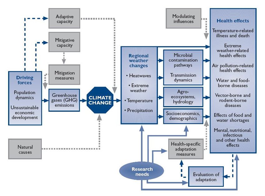
The Inter-Governmental Panel on Climate Change (IPCC) “Technical Guidelines for Assessing
Climate Change Impact and Adaptation” was adapted to the reality of Belize in terms of
availability of data, the existence of multiple regression models on Dengue and socio-economic,
environmental and climatic predictors, and available time for the conduct of the assessment.
Descriptive qualitative and quantitative methods were used where feasible, to assess the increase
level of risk to dengue and dengue hemorrhagic fever based on different scenarios of future
climate change.
Background
Dengue is the most important arboviral disease of humans, occurring in tropical and subtropical
regions worldwide. In recent decades, dengue has become an increasing urban health problem in
tropical countries. The disease is thought to have spread mainly as a result of ineffective vector
and disease surveillance; inadequate public health infrastructure; population growth; unplanned
and uncontrolled urbanization; and increase national and international travel. The main vector of
dengue is the domesticated mosquito, Aedes aegypti that breeds in urban environment in artificial
containers that hold water. Dengue also can be transmitted by Aedes albopictus, which can
tolerate colder temperatures.
Dengue is seasonal and usually associated with warmer, more humid weather. There is evidence
that increased rainfall, humidity and temperature can affect the life cycle of the vector and virus,
thus increasing the transmission potential.
19Classic Dengue Fever is considered endemic in Belize, and the Health Services has continuously
monitored the occurrence of Dengue and Dengue Hemorrhagic Fever (DHF) and has expressed
concerns over recent outbreaks of DHF in Brazil and other Central American countries. Belize
has the environmental and socio-economic conditions for such outbreaks to occur; the conditions
also exist for DHF to arise. The MOH resolved that is was timely that a vulnerability assessment
be undertaken in order to determine the present and future level of risk of this disease. Since
Dengue is a climate sensitive disease, it was expected that a change in climate parameters would
impact its frequency and distribution in the country.
Objectives of the Assessment
The main goal of this assessment is to determine the present and future occurrence of dengue and
DHF and to measure its impact on the health care system and the population in terms of
morbidity and mortality, also to measure the socio-economic impact of adaptation measures.
In order to accomplish the objectives of the vulnerability and adaptation assessment, the
consultant was asked to do the following:
Describe the present level of risk for dengue and DHF in Belize
Project the future occurrence of dengue based on present risk levels and expected
population growth, in the absence of climate change.
Utilizing selected socioeconomic and climatic scenario, project the future impact of
dengue and DHF in Belize.
Recommend adaptation strategies to cope with potential impact.
Terms of Reference
a) Scope of the Assessment
The goal of this Health Sector Vulnerability Assessment was to evaluate, under various Climate
Change Scenarios, the climate change impacts in the health sector as it pertains to changes in the
vector for Dengue and DHF
Some specific objectives included:
To identify the geographic areas, and populations at risk from or vulnerable to the disease
threat. Indicate the linkage between this study and the epidemiological profile of Dengue
and DHF in Belize.
To identify and estimate the social and economic costs to enable the Authorities to
maintain or establish control, should the threat be realized.
To identify other stakeholders with the potential to assist in mitigating the threat.
To identify and make recommendations for adaptation measures intended to reduce the
impacts of climate change on this area of the health sector. This was to be offered to the
appropriate authorities in order to guide any mitigation/adaptation strategy that might be
formulated to address the impacts of climate change on health.
20b) Risk Assessment
The present level of risk (current vulnerability) was described based on the analysis of historical
and present data related to the occurrence of dengue, and available entomological, climatic and
socio-economic information. The present adaptation capabilities have also been described within
the context of autonomous and explicit planned adaptive measures.
c) Deliverables:
Draft report that includes the following:
Geographic range/extent and vulnerable populations that would be affected by the threat
based on the projected scenarios.
projections on the social consequences and implications for the delivery of health
services
recommendations of mitigation/adaptation measures to reduce the impacts of climate
change in the Health Sector
Presentation of results for peer review prior to the production of a final report.
Deliver final report via hard and digital copy of results of the assessment to the SNC
Project Office.
d) Methodology
The method used was determined after consultation with senior staff of the National
Meteorological Service, the Statistical Institute of Belize, the Ministry of Health and the Vector
Control Program, in order to see what modeling capability and data availability existed. The
available options were to use mathematical models to predict future impact; descriptive analysis
through literature review and expert judgment; the risk management approach or a combination
thereof.
Consultation with other partners and stakeholders and comprehensive literature review, revealed
the following:
To date, no modeling studies had been conducted in Belize, linking the occurrence of dengue to
socio-economic, climatic or environmental factors. The surveillance system of the MOH does
not collect information on socio-economic risk factors for Dengue and the entomological data
that is collected is not consistent. The intensity and quality of data collection and recording,
varies over time and among health regions.
The available data does not allow for modeling (multiple regression analysis) to predict changes
in the dependent variable (incidence of dengue) for unit change in the independent variables
(climate parameters and others). The absence of such models, precluded the consultant from
making projections on future impact of dengue utilizing mathematical models.
21Taking into account the situation as described above and following the IPCC recommendations
for V&A assessment where impact data is unavailable, the following methodology was adopted:
The Bottom-up, Risk-Based Hazard assessment framework combined with the Top-down
approach to conduct the vulnerability and adaptation assessment. Under this model, the climatic,
socio-economic and environmental drivers of dengue are identified; present risk (vulnerability)
of dengue and adaptation capability of the country is described based on historic and current
data. Based on future climate scenarios, the risk management process, and utilizing expert
judgment, determination is made as to how the projected climate changes will impact on dengue
and what proactive adaptation measures needs to be implemented in order to reduce vulnerability
and minimize impact.
A cost benefit analysis of alternative adaptation measures or no adaptation was made in order to
facilitate policy decision. The risk management process provides a systematic, informative and
science-based tool to help decision makers analyze the risk of climate variability and change, and
select optimal course of action.
e) Data acquisition and compilation
Data on climate history and future projected changes was acquired from the National
Meteorological Service of Belize (NMS). The socioeconomic scenario used was that described
as the IPCC emission scenario A2, which was selected by the NMS, in consultation with other
sector of development. Data related to the frequency, distribution and trend of dengue and non-
climatic risk factors was gotten from the epidemiology unit of the Ministry of Health, the Vector
Control Program, the Statistical Institute of Belize and through a national prevalent
entomological survey financed and implemented by the SNC project, in coordination with the
Vector Control Program, in August of 2008.
Documentation for literature review was acquired from PAHO, CCCCC, SNC project
management office, NCSP and the Internet.
It was anticipated that the available rural entomological data was incomplete and inconsistent, so
that in order to generate valid information on the frequency and distribution of the Aedes aegypti
mosquito and its breeding sites, an entomological survey was conducted. Three villages were
randomly selected from each district and within each village; random selection of a
representative sample was made. This survey produced a picture (snapshot) of the risk that the
vector poses in the country. A one day technical workshop was held in Belmopan to train the
entomological surveyors in preparation for the actual data collection exercise. A brief description
of the survey protocol follows:-
22ENTOMOLOGICAL CROSS-SECTIONAL SURVEY
Objectives of the Survey
The objective of this survey was to generate the data required to estimate the Aedes aegypti
indices such as: House index, Container index, Breteau index for rural Belize, and to determine
what type were the prevailing breeding containers.
Methodology
In consideration of the objectives of the study and due to time and resource constrains, a cross
sectional survey design was utilized in order to gather prevalent information on Aedes aegypti
mosquito habitats and density.
Target Population
Since the study aims at measuring the prevalence of entomological risk factors for dengue in
rural Belize, the target population was determined to be all rural households in the country. By
definition, the target population is that proportion of the population to whom the results of the
survey is extrapolated.
Study Population
Is defined as that proportion of the target population to whom the researcher has access and from
where data collected. The study population comprised all households in the eighteen selected
communities; hence all households were included in the sampling frame.
Sampling Process
In order to get the required representative sample size for the survey, a random selection of three
villages per district was done, followed by a random selection of households within each village.
It was concluded that a combination of cluster and systematic random sampling procedures was
appropriate for this setting. The cluster sampling entailed the random selection of three villages
per district in order to have appropriate district representation; this was fallowed by systematic
random selection of households within each village.
Sample Size
For Aedes aegypti larvae survey, the determination of the number of house premises to be
inspected in each locality depends on the precision required, level of infestation and availability
of resources. Since the desired precision was 1% or less (ability to detect 1% larvae infestation),
and the expected level of infestation was 2% or greater, the methodology proposed by the 1994
PAHO “Dengue Prevention and Control Guidelines” for sample size determination was utilized.
Data Collection Procedure
23Data was collected following standardized entomological protocols. Data collection was made on
premises with water holding containers; premises with wet containers; premises with containers
with larvae; larvae stage and larvae species. This data was utilized to estimate the: House index
(HI), Container index (CI), and Breteau index (BI).
Two Entomologist Technicians per district, employees of the Ministry’s Vector Control
Programme, were selected and trained to collect field data as per protocol. Data collection was
carried out simultaneously in each district and the task was completed in three days.
Data Collection Instrument
Standardized forms utilized by the vector control program of the Ministry of Health was used to
record the entomological data
Statistical Analysis
The Statistical Program for the Social Sciences (SPSS) 10.0 was used to conduct data analysis.
Counts, Frequencies, Proportions and Percentages were generated and presented in tables and
graphs. Outputs were the following: House, Container and Breteau Indices per village and
average per district. Types of containers and container relative frequency. For detailed
information on the results of the study, see table # 5 below, and the section dealing with the
analysis of “Present Vulnerability to Climate Change”.
Table 5: Entomological Indices by District and Village, Belize 2008
District Village House Index Cont Index Breteau Index
Corozal Ranchito 4% 2% 4%
Paraiso 3% 2% 3%
Little Belize 9% 2% 9%
Orange Walk Douglas 2% 1.4% 0.2%
Fire Burn 0% 0% 0%
Trial Farm 3.8% 1.3% 4.7%
Belize Double Head 3.9% 1.1% 3.9%
Cabbage
Barrel Boom 4.2% 3.1% 4.2%
Crooked Tree 7% 2.4% 9%
Cayo Santa Familia 9% 6.32% 16%
Ontario 16% 7.28% 22%
Cristo Rey 9% 5.21% 17.14%
Stann Creek Valley Community 0% 0% 0%
South Stann Creek 14% 13.6% 24%
Hope Creek 7% 3.8% 9%
Toledo Blue Creek 4.9% 2% 4.9%
Forest Home 4% .9% 4%
San Antonio 8.7% 3% 12%
Source: entomological Survey, Vanzie et al, 2008.
24SELECTION OF SCENARIOS
Climate scenarios has been described by the IPCC as plausible, and often simplified
representation of the future climate, based on an internally consistent set of climatological
relationship that has been constructed for explicit use in investigation the potential consequences
of anthropogenic climate change, often serving as input to impact models. Climate projections
often serve as the raw material for constructing climate scenarios, but climate scenarios usually
require additional information such as the observe current climate.
In order to provide reference points with which to compare future projections, three types of
baseline conditions are specified: climatic, environmental and socio-economic. Historic and
present climatic data, A2 emission scenarios and present dengue drivers were utilized to project
future climate scenarios. e.g. we are interested in knowing the likelihood of more rainy days per
year, or longer dry season occurring. More rainy days provides more breeding condition for the
dengue vector; longer dry season force people to store water in containers that eventually
becomes mosquitoes breeding sites.
Under the A2 SRES scenario, Belize is described as a very heterogeneous country. The
underlying theme is self-reliance and preservation of local identities. Fertility patterns across the
country converge very slowly, which results in high population growth. Economic development
is primarily locally oriented and per capita economic growth and technological change
fragmented and slow.
Projection Time Frame.
The time period (time horizon) over which projections was made, took into account the limits of
predictability. The projected Climatic scenarios therefore were made for the decades of the
2020’s and 2050’s.
The projected changes in environmental and socio-economic factors were based on the global
circulating models A2 emission scenario. Climatic scenarios (plausible future climates), as
defined by the Belize National Meteorological Services, was utilized in order to project possible
impact on dengue.
Disease selection
The decision to select Dengue as the disease to be studied in relation to its vulnerability to
climate change was made by the Ministry of Health based on the following factors:-
Classical dengue is endemic in Belize and hence the risk of occurrence of the fatal
dengue hemorrhagic fever exists.
Studies have revealed that the occurrence of dengue fever is sensitive to temperature,
humidity and rainfall increase.
The IPCC’s Third Assessment Report (2001) projects and increase in average world
surface temperature ranging from 1.4 to 5.8˚C and change in seasonality and weather
patterns over the course of the twenty-first century.
25IMPACT ASSESSMENT
Impacts are estimated or projected as the differences over the study period between the
environmental and socio-economic conditions projected to exist without climate change and
those that are projected with climate change. The assessment includes qualitative and
quantitative analysis and cost-benefits analysis.
Modeling impact and adaptation strategies in the health sector is an emerging field; the number
of tools and approaches available explicitly designed for this purpose is still limited. The
consultant therefore, in the absence of regression models to project future impacts, focused
mainly on the risk management process to determine future vulnerability and required adaptation
measures.
ADAPTATION ASSESSMENT
Response (Adaptation), are actions taken to reduce vulnerability or to reduce impact. These can
be autonomous or planned. The burning of vegetable materials (e.g. cohune shell) in rural areas,
and fish coils in urban households as mosquitoes repellent, is an example of autonomous
adaptation. The spontaneous use of bed nets is also an autonomous response of individuals to a
perceive risk. The planned response is that undertaken by the community, by local or national
authorities in response to a policy decision. An example in Belize of a planned response is the
Dengue control program of the Ministry of Health. This program was described in the
introductory section of this document, hence there is no need to say more about it here, except
that the program has room for improvement in the execution of planned activities and
strategically it can be categorized as unsustainable. Not withstanding, the program has a
surveillance component that assist in monitoring frequency and distribution of the disease and
trend over time. The level of present adaptation capacity is no doubt mitigating the impact of
dengue, but not enough to reduce the risk to levels where the likelihood of dengue transmission
is minimal.
STUDY OUTPUTS
Results of this study have been presented in a report, produced in digital and hard copy,
describing:-
(a) Background Information on Dengue
Clinical dengue
Definition, signs and symptoms
Dengue is an acute febrile viral disease characterized by sudden unset, fever for 3-5 days, intense
headache, myalgia, arthralgia, retro-orbital pain, anorexia, gastrointestinal disturbances and rash.
Minor bleeding phenomena, such as petechiae, epistaxis or gum bleeding may occur at any time
during the febrile phase. If in addition to the above symptoms, the patient presents also with
26signs of increase vascular permeability, hypovolemia and abnormal blood clotting mechanisms,
the diagnosis of Dengue Hemorrhagic Fever (DHF) is made.
Diagnosis
A confirmatory case of Dengue is made when the virus is identified from a blood sample or a
serological reaction to the dengue virus antigen occurs. The main procedures for laboratory
diagnosis of dengue are known as virus isolation and characterization; molecular diagnosis;
antigen detection and antibody detection. Each test has different degrees of complexities,
sensitivity and specificity. Generally speaking, viral identification and characterization methods
requires greater degree of technical capability and for this reason, most countries or regions
conduct this procedure a few times during the initial phase of new outbreak. In some countries
where laboratory capacity does not exist, symptomatic diagnosis of Dengue is accepted.
Types of dengue
The viruses of Dengue Fever are flaviviruses and include serotypes 1, 2, 3, and 4. The same
viruses are responsible for DHF. Two or more infections to the same individual with different
serotypes appear to increase the probability of developing DHF. Infection with one serotype
confers immunity for life for that serotype but not against the other three
Dengue Hemorrhagic fever (DHF), Dengue shock syndrome
DHF is a febrile disease that is characterized by high fever, hemorrhagic phenomena, often with
hepatomegaly, and, in severe cases, signs of circulatory failure. Such patients may develop
hypovolemic shock resulting from plasma leakage. This is called dengue shock syndrome (DSS)
and can be fatal.
The disease was first recognized in the Philippine in 1953. The syndrome was etiologically
related to dengue viruses when serotypes 2, 3, and 4 were isolated from patients in that country
in 1956; 2 years later dengue viruses of multiple types were isolated from patients during an
epidemic in Bangkok, Thailand. During the next three decades, DHF was recognized in
Cambodia, China, India, Indonesia, the Lao People’s Democratic republic and several Pacific
Island. As of 2007, DHF is present in most tropical countries of all continents.
In each country of the regions where DHF has become endemic, the sequence has been more or
less the same; frequent transmission of dengue viruses, first associated with sporadic cases of
DHF, fallowed by DHF epidemics which progressively become more frequent, until DHF cases
are seen virtually every year with major epidemics occurring at 3-5 years intervals. Depending
on the severity of the outbreak and the existence of favorable conditions, the percentage of DHF
could go anywhere from 2 to 10% of the total number of cases in any given outbreak.
(b) Epidemiology of dengue
Distribution
27You can also read