ATTI DELLA SOCIETÀ TOSCANA SCIENZE NATURALI - Resolve a DOI ...
←
→
Page content transcription
If your browser does not render page correctly, please read the page content below
ATTI
                   DELLA
  SOCIETÀ TOSCANA
                      DI
 SCIENZE NATURALI
MEMORIE • SERIE A • VOLUME CXXVII • ANNO 2020

                  Edizioni ETS

                                                    INDICE - CONTENTS

G. Cucurnia – L’alluvione di Marina di Carrara (Tosca-                   S. Merlino – The OD nature of perrierite and chev-
na, Italia) del 5 novembre 2014: descrizione dell’evento                 kinite.
meteo-idrologico ed analisi dei fattori geografici e geo-                La natura OD di perrierite e chevkinite.                 »   55
morfologici predisponenti.
Marina di Carrara (Tuscany, Italy) flood on November                     C. Biagioni – A new occurrence of a Mg-rich member
5, 2014: description of the meteo-hydrological event and                 of the chabazite series from Tuscany (Italy).
analysis of predisposing geographic and geomorphologi-                   Un nuovo ritrovamento di un termine ricco in Mg della
cal factors.                                                 pag.    5   serie della cabasite dalla Toscana (Italia).             »   61

R. Grifoni Cremonesi – Grotte, fosse, circoli di pie-                    S. Pagnotta, M. Lezzerini – Comparison between
tre, offerte vegetali e animali, acque e simboli: testi-                 Leeb and Knoop hardness on metakaolin-based geo-
monianze di culti e riti nella Preistoria italiana.                      polymers.
Caves, ritual pits, stone circles, vegetables and animals                Confronto tra la durezza di Leeb e Knoop di geopolime-
offerings, water and symbols: evidences of cults and rites               ri a base di metacaolino.                                »   67
in the Italian Prehistory.                                    »     15
                                                                         F. R apetti – La pioggia a Livorno (Toscana, Italia)
P. Balocchi – Tectonics and seismotectonics of high                      (1857-2019).
Dragone valley between Piandelagotti and Montefio-                       The rain in Leghorn (Tuscany, Italy) (1857-2019).        »   75
rino villages (Northern Apennines, Italy).
Tettonica e sismotettonica dell’alta valle del Dragone                   PROCESSI VERBALI
tra i paesi di Piandelagotti e Montefiorino (Appennino                   Pubblicati nel sito http://www.stsn.it
Settentrionale, Italia).                                      »     29   Published on the internet site http://www.stsn.it

A. Petroccia, M. Bonasera, S. Nerone, F. Caso,
M. Morelli, D. Bormioli, G. Moletta – Geologi-
cal guide to the excursion in the upper Maira Valley
(Western Alps, Italy).
Guida geologica all’escursione in alta Valle Maira (Alpi
Occidentali, Italia).                                         »     41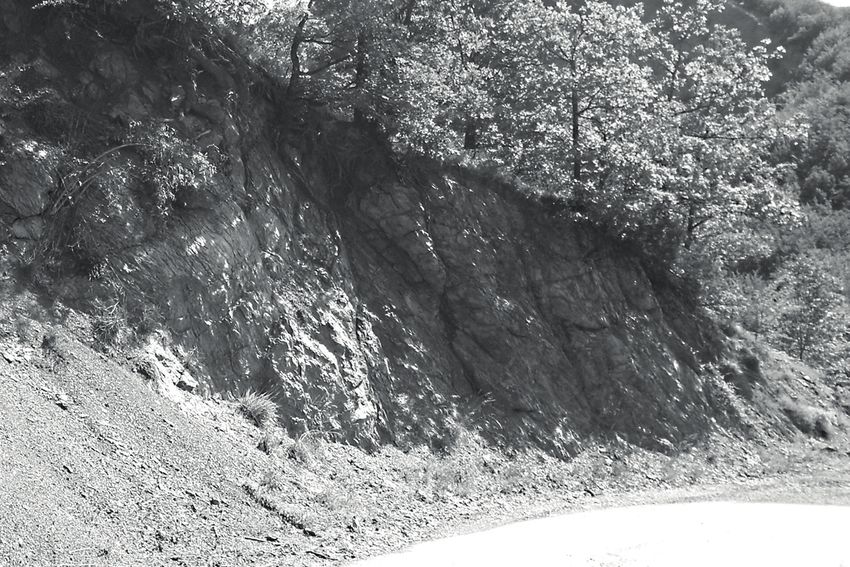
Atti Soc. Tosc. Sci. Nat., Mem., Serie A, 127 (2020)
pagg. 29-39, figg. 9; doi: 10.2424/ASTSN.M.2020.01

                                                             Paolo Balocchi (1)

       TECTONICS AND SEISMOTECTONICS OF HIGH DRAGONE VALLEY
         BETWEEN PIANDELAGOTTI AND MONTEFIORINO VILLAGES
                    (NORTHERN APENNINES, ITALY)

Abstract - P. Balocchi, Tectonics and seismotectonics of high Dragone       Introduction
valley between Piandelagotti and Montefiorino villages (Northern Apen-
nines, Italy).
                                                                            A small seismic sequence in the Sant’Anna Pelago area,
A small seismic sequence in the high Modena Apennines (Sant’Anna            occurred in 2018-2019 period with a main earthquake
Pelago area) occurred in the 2018-2019 period with a main earth-
quake of M W 3.6 on July 1, 2018. The existent geological literature
                                                                            of MW 3.6 on July 1, 2018. Other earthquakes occurred
does not suggest the presence of a Quaternary active fault that can         in the area, and they show a typical geometry of a seis-
explain this seismic sequence. Small earthquakes are related to the         mic cluster. The geological maps of this area (ISPRA,
same seismogenic process of strong earthquakes and, generally,              2000; Cerrina Ferroni et al., 2002a, 2002b; Plesi et al.,
earthquakes are generated by minor structures associated with re-           2002a), do not support the existence of Quaternary
gionally important faults, which define the main rupture zone. The          faults that can motivate the seismic sequence. Further-
structural analysis of mesoscopic faults in outcropping rock-units,
and the analysis of hypocentres distribution, provided important
                                                                            more, in scientific literature is not described a seismo-
information on the geometry, kinematics, and tectonic stress of the         genic source (DISS Working Group, 2015) responsible
main regional fault systems responsible for the occurred seismic            for this seismic sequence.
event. This paper proposes the seismotectonic model of high Drago-          The structural analysis of mesofaults, on different out-
ne valley, when the mesostructural analysis describes the main sur-         crops, can give information on the geometry, defor-
face fault systems and the horst and graben structure of Riccovolto         mation and stress, along the surface faults (Balocchi,
village, while, the analysis of hypocentres distribution shows a shal-
                                                                            2014; Balocchi & Santagata, 2018), and the analysis
low detachment structure. The model represents clearly an active
extensional system of regional importance.                                  of the distribution of hypocentres can provide very
                                                                            important information on the geometry of the deep
Key words - seismic cluster, detachment, horst and graben, strike-slip      seismogenic source, as described in some papers (Ba-
fault, Modino unit, Northern Apennines, Italy                               locchi et al., 2016; Chiaraluce et al., 2014; Cheloni et
                                                                            al., 2017; Balocchi & Riga, 2017, 2018). Furthermore,
Riassunto - P. Balocchi, Tettonica e sismotettonica dell’alta valle del     studies carried out on low-magnitude earthquakes can
Dragone tra i paesi di Piandelagotti e Montefiorino (Appennino Setten-
trionale, Italia).
                                                                            provide useful information on the seismotectonic and
                                                                            seismogenic context as well as on the seismic process-
Una piccola sequenza sismica nell’area di Sant’Anna Pelago, si è veri-
ficata nel periodo 2018-2019 con un terremoto principale di M W 3,6
                                                                            es that generated the sequence and the strong earth-
del 1° luglio 2018. La letteratura geologica esistente non prevede l’e-     quakes associated (Chiaraluce et al., 2004; Chiarabba
sistenza di una faglia quaternaria attiva che motivi questa sequenza        et al., 2014). Small earthquakes, in fact, are related to
sismica. I piccoli terremoti sono legati agli stessi processi sismoge-      the same seismogenic processes of strong earthquakes.
netici dei forti terremoti e, generalmente, sono generati da strutture      In general, they are associated with minor seismogenic
minori associate alle faglie di importanza regionale, che definiscono       structures, which along with the main ones, determine
la zona di rottura principale. L’analisi strutturale delle faglie meso-
scopiche nelle unità affioranti, e l’analisi della distribuzione degli
                                                                            the main rupture zone.
ipocentri, ha fornito importanti informazioni sulla geometria, sulla        The comparison between structural geological data
cinematica e sullo stress tettonico dei principali sistemi di faglie re-    and seismological data is very important to describe
gionali. Questo articolo propone il modello sismotettonico dell’alta        the tectonic and seismotectonic model of the seismo-
valle del Dragone, dove l’analisi mesostrutturale descrive i principali     genic source both at the surface and in the crust. For
sistemi di faglie superficiali e la struttura horst and graben di Ric-      these reasons, this study is designed to analyze the
covolto, mentre, l’analisi della distribuzione degli ipocentri mostra
una struttura di scollamento poco profondo. Questo modello rap-
                                                                            mesofaults, with the aim of determining the geome-
presenta chiaramente un sistema estensionale attivo di importanza           try and kinematic of the main fault systems and pos-
regionale.                                                                  sible macroscale structures. Furthermore the seismo-
                                                                            logical analysis of the earthquakes distribution, with
Parole chiave - cluster sismico, scollamento, horst e graben, faglia tra-   the objective of determining the geometry and kine-
scorrente, unità Modino, Appennino settentrionale, Italia                   matics of crustal sources and their possible seismic
                                                                            clusters. The ultimate goal is to describe the tecton-

(1)   Geologist, independent researcher, 41123 Modena; E-mail: georcit@gmail.com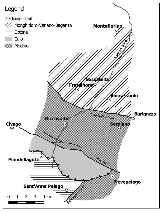
30                                                    P. BALOCCHI

ics and seismotectonics model of the high Dragone
creek valley between Piandelagotti and Montefiorino
villages.

R egional geology and tectonics

The Northern Apennines is a thrust and fold belt
(Elter, 1960; Reutter & Groscurth, 1978) mainly
formed in the Tertiary. It is commonly considered as
the result of the convergence between the European
plate and Adria microplate, a fragment of the more ex-
tended Africa plate (Boccaletti et al., 1971; Boccaletti
& Guazzone, 1972). The convergence generates a sub-
duction plane approximately inclined at 65-70° plung-
ing beneath the Appennines (Malinverno & Ryan,
1986; Doglioni, 1991; Carminati et al., 1999; Doglioni
et al., 1999; Scrocca et al., 2006; Riguzzi et al., 2010).
The Apennine chain derives from the deformation of
different Meso-Cenozoic paleogeographic domains,
formed during the rifting of the Ligure-Piemontese
ocean (Abbate et al., 1970). Subsequently the closure of
the Ligure-Piemontese ocean, caused the building up
of an accretionary prism (Treves, 1984), the complete
consumption of the oceanic lithosphere, and finally
the collision of the two continental plates with the
formation of orogenic wedge, where rocks that previ-
ously occupied paleogeographic domains side by side
now are overlapped. During the closing phase of the          Figure 1. Schematic tectonics map of area with tectonics unit and main
Ligure-Piemontese ocean, the Liguri units overlapped         fault systems.
forming an oceanic accretionary prism, where the
different tectonic units are bounded by thrust faults.       (Puccinelli et al., 2016a, 2016b), characterized by Com-
Above these units, the Epiligure succession sediment-        plesso di Casanova and Flysch di Ottone formations.
ed inside piggy-back basins (Ricci Lucchi & Ori, 1985;       The tectonic contact between the Caio and Ottone
Bettelli et al., 1989a, 1989b). The Ligurian accretionary    tectonic unit is characterized by overthrust.
prism overthrust progressively the Tuscan units, which       In the northern area the Monghidoro tectonic unit
had previously settled on the continental Adria crust.       (Upper Cretaceous-Paleocene) represents the highest
The geology of the high Dragone creek valley (Nar-           Ligurian unit outcropping in the area. The unit is char-
di & Tongiorgi, 1962; Bertolli & Nardi, 1966; Plesi          acterized, on the macrostructural scale, by the alterna-
et al., 2002a, 2002b; Puccinelli et al., 2016a, 2016b) is    tion of upright e overturned limbs, that they follow
characterized by the presence of rocks belonging to          each other vertically and horizontally over relatively
the Ligurian (Upper Jurassic-Middle Eocene) and to           large distances. The lower part of the unit is charac-
the underlying Tuscan units (Cretaceous-Miocene).            terized by a upright succession outcropping along the
These two groups of units crop out in the area with a        Dragone valley and, it is composed only of the Mon-
juxtaposition relation, due to fault contacts of region-     te Venere formation. The middle zone of the studied
al importance (Bettelli et al., 2002; Plesi et al., 2002a;   area is represented the overturned succession, that it is
Puccinelli et al., 2016a). The units belonging to the        outcropping further north, where the Dragone creek
Ligurian are outcropping in the northern and south-          flow into Dolo creek. According to some authors (Bet-
ern sector, while the Tuscan units in the central sector     telli & Panini, 1992), the upright and overturn limbs,
and South-East sector (Fig. 1).                              which originally constituted the Rossenna syncline,
The Ligurian units in the southern block are repre-          they were cut from an extensional fault of regional im-
sented by the Caio tectonic unit (Bettelli et al., 1989b;    portance. This unit overlaps the Venano tectonic unit
Plesi et al., 2002a, 2002b), characterized on the macro-     (Upper Cretaceous) or, the Baganza tectonic unit (Ju-
scale by the Argilliti di San Siro (Cenomanian-Upper         rassic-Cretaceous), where it is present.
Campanian) and the overlying Flysch di Caio (Upper           The Venano unit (Daniele at al., 1996) is represented
Campanian) formations, and the Ottone tectonic unit          at the macroscopic scale by overturned limbs of Are-
                                                             narie di Poggio Mezzature and Argilliti dell’Uccelliera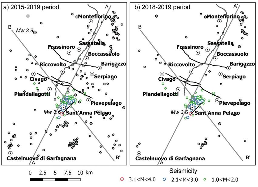
TECTONICS AND SEISMOTECTONICS OF HIGH DRAGONE VALLEY                              31

formations, while the Baganza unit is characterized by       the seismotectonic cartography (Martelli et al., 2016a,
the Argille a Palombini formation and ophiolites.            2016b). This hypothesis is supported by the descrip-
The rocks belonging to the Modino tectonic unit out          tion of abundant and numerous natural oil and meth-
crop in the central area and in the South-East sector.       ane emissions along both sides of the Dragone valley
The most important macrostructural characteristic is         (Martelli et al., 2016a). In particular, these methane
represented from subdivision into tectonic scales by         emissions define NW-SE alignment, that extends
lateral and vertical extension, more or less large, which    from the Dragone valley towards SE up to Fanano.
determine alternations of upright and overturned             The emissions were located around Sassatella village,
limbs.                                                       and in the easternmost area of Barigazzo and Boc-
The northern Apennine sector between the Secchia             cassuolo. Currently these emissions are extinct due
river and the Idice creek is characterized by an ex-         to the exploitation of hydrocarbons in the vicinity of
tensional tectonics that mainly affects the Ligurian         natural vents. However, it is interesting to note, that
nappe, after its emplacement on the Tuscan units.            these manifestations were almost coincident with the
This extensional tectonics was manifested starting           normal faults described above, with the Apennines di-
from the Messinian through the genesis of high-angle         rection, which provided preferential structural paths
fault systems with longitudinal direction to the Apen-       channels for the ascent of fluids.
nine chain, that it mostly concerns the Ligurian units       A fault systems characterized by NE-SW direction
and the Epiligure succession (Bettelli et al., 2002a; Ba-    and NW dip-direction is present in the South-East
locchi, 2014). The “internal lineament” (Bettelli et al.,    sector (Puccinelli et al., 2016b), and its name in this
2002b) is the most important of these fault systems,         study is Sant’Anna faults. It is a tectonic contact of
which constitutes the emerging boundary between              overthrusting of Miocene epoch, between Ligurian
the Tuscan and the Ligurian units of the upper Mode-         unit (the Complesso di Casanova in Ottone tectonic
na and Bologna Apennines. It is represented by sev-          unit) outcropping in the west sector, and Modino tec-
eral normal fault systems in the Apennine direction,         tonic unit outcropping in the east sector.
by extending from the Dolo valley to the Futa Pass.
Transversal, SW-NE direction, tectonic lines to the
Apennine chain are associated with these longitudi-          Structural analysis of mesoscopic faults
nal, NW-SE direction faults. They represent vertical
strike-slip transfer faults and are generated by the seg-    The structural survey is important to describe the ge-
mentation and the en échelon arrangement of the var-         ometry and the kinematics, of the main fault systems.
ious segments that make up the “internal lineament”          For this reason, the studied outcrops are those in
(Bettelli et al., 2002b). In the studied area, the single    proximity to the macroscopic faults (Fig. 2).
segment of the “internal lineament” is represented by        The data on the mesoscopic faults of the Barigazzo sys-
the Barigazzo fault system (Bettelli et al., 2002b), char-   tem are derived from studies by other authors (Martel-
acterized by NE dip-direction and NW-SE direction            li et al., 2016). This system is represented by high-angle
(Martelli et al., 2016). This system involves the Modi-      normal mesoscopic faults by NW-SE direction and
no tectonic unit and lowers the Ligurian units of the        NE dip-direction. These mesoscopic faults in Modino
northern area. These faults are superimposed on tec-         tectonic unit outcrops, almost always move down the
tonic elements related to the compression phase, and         Ligurian unit and they show recent activity.
in some places the normal faults reactivate the existing     The mesoscopic faults of the Fola system were meas-
weak areas (Martelli et al., 2016).                          ured in Marne di Marmoreto formation of the Modi-
In the geological and seismotectonic maps (Plesi et al.,     no tectonic unit, the tectonic fabric of the formation
2002b; Martelli et al., 2016a, 2016b) the tectonic con-      is characterized by lenticular or lozenge-shaped small
tact between the Caio and the Modino tectonic units          rock bodies and bounded by shear surfaces (Remitti et
(informally named by various field geologists as the         al., 2007, 2011). The Fola system in outcrop, clear cuts
“Fola fault”, as the homonym medieval bridge located         the structures by high-angle mesofaults wiyh NW-SE
near Pievepelago), is described as high-angle normal         direction and SW dip-direction (Fig. 3). Other normal
fault by NW-SE direction. Its longitudinal extension         mesoscopic faults show a W-E direction and they rep-
has different interpretations, in fact in the geological     resent a secondary segments of the Fola fault (Fig. 2).
map it extends from Pievepelago towards Civago with          This fault systems represents the boundary between
a continuation towards NW, while in the seismotec-           Modino tectonic unit in the northern block and Caio
tonic map it is described with longitudinal extension        tectonic unit in the southern block, a tectonic contact
of a few kilometers from the Dragone creek to Civago,        that it moves down the Ligurian units. In outcrops,
and always with continuation towards NW.                     this normal mesoscopic faults reactivated the preexist-
The Barigazzo fault system that juxtapose Ligurian           ing shear surfaces bounding the rock slices (cfr. Mar-
and Tuscan units, are considered potentially active in       telli et al., 2016a).
32 P. BALOCCHI
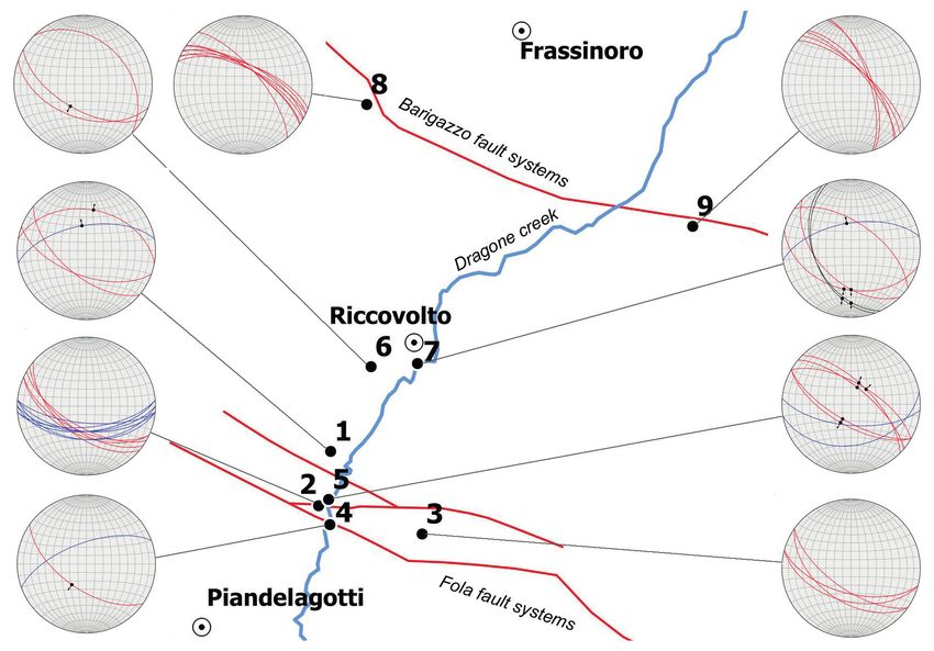
Figure 2. Simplified structural
map of study area, with out-
crops and mesoscopic faults
stereograms.
In the outcrops localized near the Riccovolto village, be classified as a seismic sequence, with two main
the mesoscopic faults show geometry similar to that earthquakes of MW 3.9 on December 9, 2016 and MW
described for the other two fault systems. Further- 3.6 on July 1, 2018. The earthquakes distribution is
more, the outcrop 7 shows the Flysch dell’Abetina quite regular in magnitude and depth with some seis-
Reale above the Argille di Fiumalbo, an overturned mic clusters.
succession (Plesi et al., 2002b). The boundary between The seismicity in the 2018-2019 period (Figs 5b and 6),
the two formations is represented by two conjugate after the MW 3.6 earthquake, increases in the magni-
normal mesoscopic faults (Fig. 4) displaying clearly tude and number of events and it shows more concen-
that the Abetina Reale on the hanging wall, sliped trated of earthquakes in the southern area, forming a
down with respect the Argille di Fiumalbo forming seismic cluster near Sant’Anna Pelago village.
the foot wall. Other mesofaults show a NNW-SSE In the same periods, the hypocentres time series is
direction with the same kinematic indicators of the more distributed at the depth of 10 km about, with
previous mesoscopic faults. The mesoscopic faults of several earthquakes at greater depth.
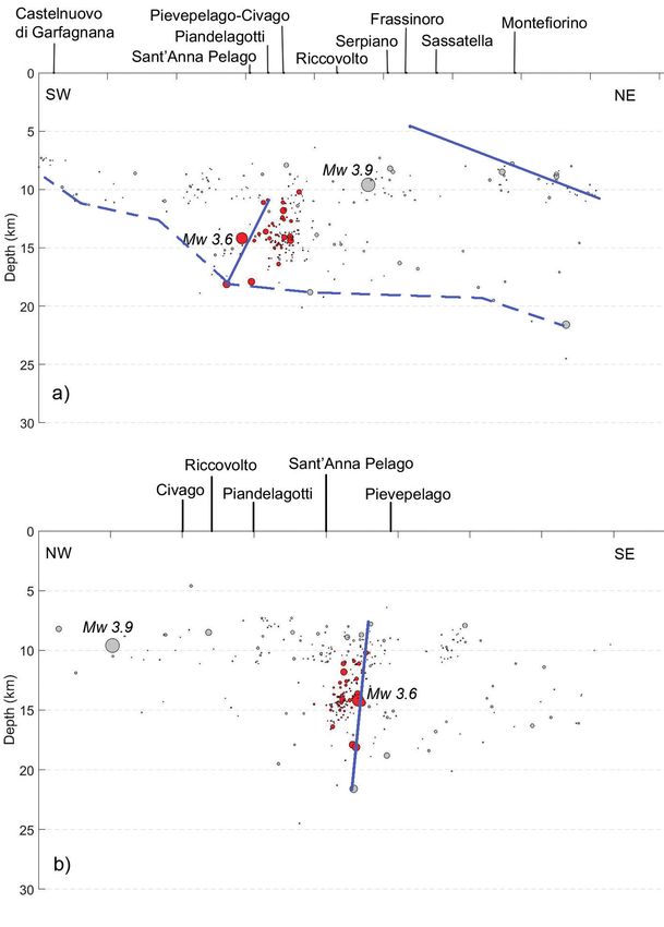
the outcrop 6 and 7 (Fig. 4) are characteristics of sec- The Seismic Cross-Section (Fig. 7a) shows how seis-
ondary tectonic structures and not related to the two micity is concentrated at the depth of 10 km, with a
main faults of the Barigazzo and Fola. They can be slight tendency to deepen from SW to NE, and it is
interpreted as the secondary faults that are generally followed by a depth increase to the NE. The hypocen-
found in the Horst axis. tres distribution shows the preferential alignments of
the main earthquakes. The SW-alignment is located at
a depth of 10 to 15 km and includes the MW 3.6 earth-
Seismology quake, while the NE-alignment is in the northern area
at more shallow depth. Another alignment is high-
The seismicity of the high Dragone creek valley area lighted from the bottom of seismogenic layer, where
(Fig. 5) has been described with the ISIDe catalogue, the hypocentres are more concentrated, that it increas-
of the “Istituto Nazionale di Geofisica e Vulcanolo- es its depth from SW to NE. The Sant’Anna alignment
gia” (INGV, 2019a). Magnitudes range of 1.0-4.0 and is located at a depth of 8 to 22 km (Fig. 7b) and the
depths shallower than 30 km were taken into account. hypocentres distribution shows a different thickness
Data were analysed in order to understand the seis- of the seismogenic layer between west and east sector.
micity evolution over time and obtain a hypocentres The 3D seismology block (Fig. 8) shows how the earth-
cross-section along the seismic sequence. quakes distribution of the SW-alignment are approxi-
The seismicity of the area, analysed in the 2015-2019 mated to a planar surface with NW dip-direction and
period (Figs 5a and 6) shows that the earthquakes can the depth of the hypocenters increases towards SW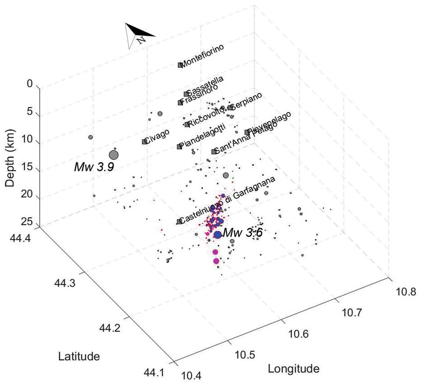
TECTONICS AND SEISMOTECTONICS OF HIGH DRAGONE VALLEY 33
Figure 3. Marne di Marmoreto formation in outcrop 2 (for location see Fig. 2).
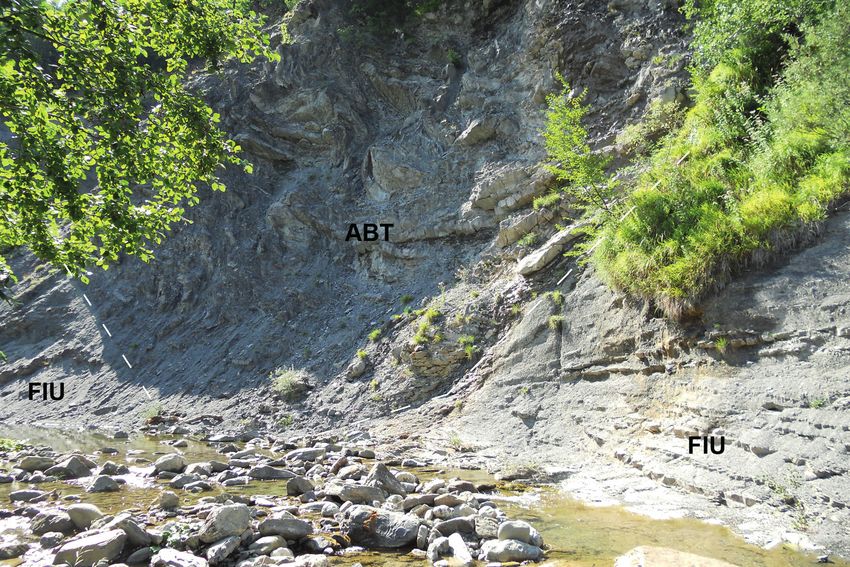
Figure 4. Flysch dell’Abetina Reale (ABT) and Argille di Fiumalbo (FIU) formations in outcrop 7 (for location see Fig. 2). The
conjugate mesoscopic faults are shown in dashed white line.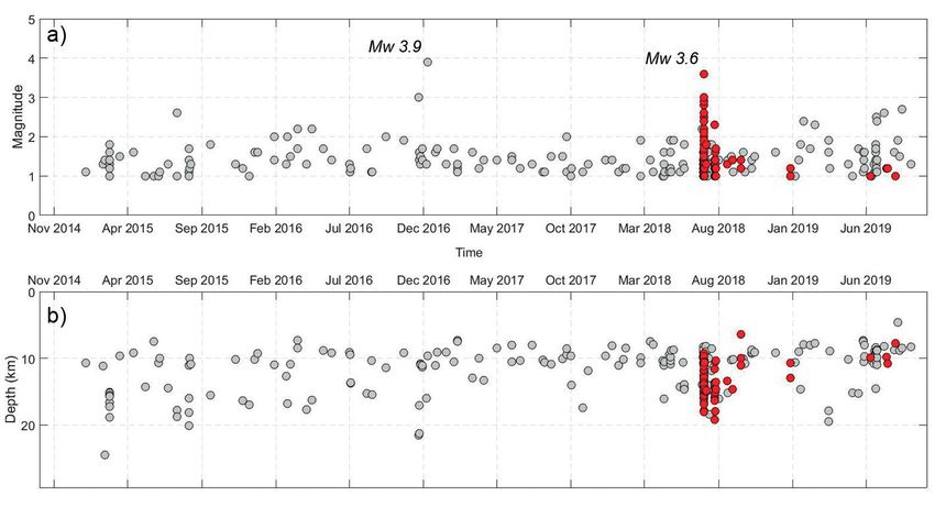
34                                                    P. BALOCCHI

                                                                                             Figure 5. The earthquakes
                                                                                             distribution with colours cir-
                                                                                             cles size is the earthquakes
                                                                                             magnitude in the 2015-2019
                                                                                             period and 2018-2019 period.
                                                                                             The earthquakes magnitude of
                                                                                             Sant’Anna Pelago seismic clus-
                                                                                             ter is with circumferences. The
                                                                                             cross-sections A-A’ and B-B’ are
                                                                                             in the figure 7.

                                                                                             Figure 6. Magnitude (a) and
                                                                                             depth (b) seismicity time in
                                                                                             2015-2019 period by grey cir-
                                                                                             cles. The San’Anna Pelago
                                                                                             seismic cluster is shown with
                                                                                             red circles.

along the plane. They show a geometry of seismic clus-       information about the tectonic stress direction and the
ter, as described in other studies (Doglioni et al., 2015;   geometry and kinematic of the main faults in the Drag-
Petricca et al., 2015; Balocchi et al., 2016; Balocchi &     one valley area. The tectonic stress main axes indicate a
Riga, 2017, 2018) and seismogenic surface (Balocchi et       direction of maximum vertical compression and a NE-
al., 2016). The strongest earthquakes seem to approxi-       SW average-direction of maximum horizontal tension.
mate a surface with SW dip-direction. The NE-align-
ment and bottom of seismogenic layer approximate
the strongest earthquakes with two different surfaces        Tectonic and seismotectonic considerations
by NE dip-direction and different inclination.
The focal mechanisms of the two main earthquakes of          The data collected in the outcrop and their structural
MW 3.9 and MW 3.6, obtained from the “Time Domain            geological analysis (Fig. 2) allow us to obtain impor-
Seismic Moment Tensor” (Dreger, 2003; Sconamiglio            tant information to describe the geometry and kine-
et al., 2009; INGV, 2019b) provide us with some useful       matics of the main fault systems (Fig. 9).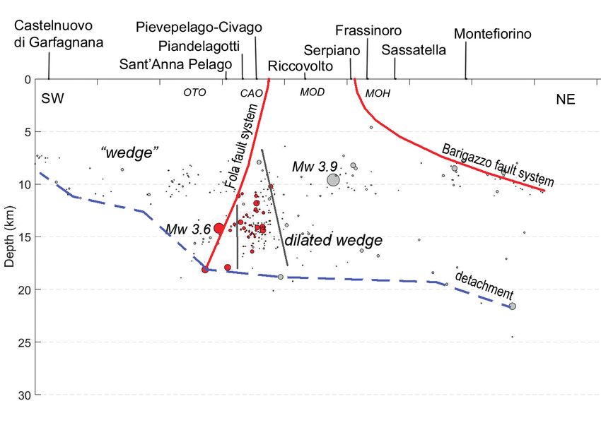
TECTONICS AND SEISMOTECTONICS OF HIGH DRAGONE VALLEY                            35

Figure 7. Seismic cross-sec-
tion with the 2015-2019 seis-
micity period in grey circles
and San’Anna Pelago seismic
cluster in red circles, along: a)
trace A-A’ in fig. 2 with NE and
SW alignments are shown by
continuous line, while bottom
seimogenic layer is in dashed
line; b) trace B-B’ in fig. 2 with
Sant’Anna alignment.

The Modino tectonic unit is limited to the north by             The Barigazzo and Fola fault systems, are the tectonic
the Barigazzo fault system, characterized by high-an-           contacts between the Modino tectonic unit and Mong-
gle normal faults with NW-SE direction and NE                   hidoro-Venano-Baganza to the north and Caio tecton-
dip-direction. Its southern limit is represented by the         ic units to the south. These fault systems juxtapose the
Fola fault system, characterized by high-angle normal           Tuscan units (Modino tectonic unit) to the Ligurian
faults with the same direction of the Barigazzo fault           units (Monghidoro-Venano-Baganza and Caio tectonic
system and SW dip-direction. Furthermore, the Mod-              units), due to the relative lowering of the second units
ino tectonic unit in the Riccovolto represents a struc-         compared to the first ones. As also the fault systems
tural high, characterized by normal conjugated fault            emerging near Riccovolto village, represent the brittle
systems typical along the Horst axis, and kinematically         deformation due to the relative uplift of the Modino
in agreement with the other systems.                            tectonic unit, compared to the Ligurian of the north-
                                                                ern and southern sector.
36 P. BALOCCHI
Figure 8. 3D seismic block of study area with
2015-2019 seismicity period in grey circles
and San’Anna Pelago seismic cluster in color-
ed circles.
The epicentres distribution of seismic data in 2015- The seismic source of the Fola fault systems is located
2019 period (Fig. 5a), show a greater concentration at a depth of 10 to 15 km and includes the MW 3.6
in the southern area, where a MW 3.6 earthquake oc- earthquake. It is characterized by NW-SE direction
curred on July 1, 2018, and Sant’Anna Pelago seismic and SW dip-direction with high-angle of inclination
cluster is nucleated along a Sant’Anna fault surfaces and a it is associated with a seismic source of Sant’Anna
by NE-SW direction, but it is more plausible, that the by NE-SW direction. The Fola fault system represents
main fault surfaces is characterized by NW-SE direc- the macroscopic expression of important high-angle
tion and normal kinematics of the Fola fault, in ac- regional normal fault, with Apennines direction and
cording to the focal mechanism of MW 3.6 earthquake. SW dip-direction. The Sant’Anna fault systems can be
The hypocentres analysis by 3D seismology block and interpreted as strike-slip fault probably with left-later-
cross-section (Figs 7 and 8), shows the preferential al kinematics, in according to stress direction of focal
alignments of greater magnitude earthquakes, that mechanism data of MW 3.6 earthquake, and it inter-
they tend to approximate a planar surface, that they sects the Fola faults in deep.
can be interpreted as deep seismogenic faults (Fig. 9). Other seismic source is located at the bottom of seis-
Moreover the aftershocks of the Sant’Anna Pelago seis- mogenic layer, and it is characterized by NW-SE di-
mic cluster are more distributed along the Sant’Anna rection and NE dip-direction with low-angle of incli-
fault systems, but the hypocenters increases towards nation. It extends its surface, from a depth of 10 km
SW along the plane, following the dip-direction of the at Castelnuovo di Garfagnana to a depth of 20 km at
Fola fault. For this reason it is plausible to hypothe- Montefiorino. The focal mechanism show a region-
size that the Fola fault is the main structure and the al extension of the high Dragone creek valley area,
Sant’Anna fault is a secondary structure. with NE-SW direction, and it is in agreement with
The seismic source of Barigazzo fault systems is locat- the mesostructural data. This seismogenic layer rep-
ed in the northern area at a low depth, characterized by resents a low-angle normal faults with Apennines di-
NW-SE direction and NE dip-direction with intermedi- rection and NE dip-direction and it is parallel to the
ate dip. It shows a structural continuity in depth and it top of the basement, as described by some authors
represents the macroscopic expression of the internal lin- (Brozzetti et al., 2007; Eva et al., 2014). Its geometry
eament described in the literature (Bettelli et al., 2002a, is similar to detachment of Altotiberina and Castel-
2002b). In fact, it represents a normal listric regional luccio-Amatrice fault systems (Balocchi & Riga, 2017,
fault, with Apennines direction and NE dip-direction. 2018).TECTONICS AND SEISMOTECTONICS OF HIGH DRAGONE VALLEY 37
Figure 9. Tectonic and seismotec-
tonic model with main structures of
the Barigazzo and Fola fault systems
and the detachment. The 2015-2019
seismicity period in grey circles and
San’Anna Pelago seismic cluster in
colored circles. Tectonic units of
Caio (CAO), Monghidoro- Vena-
no-Baganza (MOH), Ottone (OTO)
and Modino (MOD).
The Fola fault ends against to the detachment at depth tonic units, and it can be interpreted like a strike-slip
about 15 km, where is nucleate the MW 3.6 earthquake fault, probably a tear-fault with left-lateral kinematics.
on July 1, 2018. The Sant’Anna Pelago seismic cluster The hypocenters show a control in the thickness seis-
and its MW 3.6 earthquake, is distributed in depth, be- mogenic layer, within two different sector delimited
tween detachment and Fola fault, and its characteristic by this fault. This structure intersects the Fola fault to
is typical of dilated wedge (Balocchi & Riga, 2017). deep, and it drives the distribution of aftershocks in
depth, but the main seismicity is strongly connected
to the Fola fault systems, in accordance with the focal
Final remarks mechanism and the hypocenters distribuition.
The conjugate faults of Fola and the detachment form
The study of regional tectonic, mesofaults analysis and a “wedge” that, being subjected to gravity, it collapses
seismicity, allowed to get a seismotectonics cross sec- generating a graviquake (Doglioni et al., 2015; Petricca
tion, where the geometry and seismogenesis of main et al., 2015; Balocchi & Riga, 2017). The seismicity of
structures is described. Sant’Anna Pelago seismic cluster is generated by the
The tectonic and seismotectonics model consist of two formation of a dilated wedge, characterised by expan-
main structures: the Barigazzo system is a normal fault sion fractures and dilatancy (Main et al., 2013). The
with Appennines direction and NE dip-direction, detachment is an important structure in regional seis-
and the Fola system is a high-angle normal fault with mogenesis. In fact considering some studies conduct-
same direction of previous one, and SW dip-direction ed in different areas (Chiaraluce et al., 2004; Balocchi
(Fig. 9). This regional structure represents a horst and & Riga, 2017, 2018; Vadacca, 2020), if the deformation
graben, where the structural high of Riccovolto is the along its fault plane is of stik-slip type then it is plau-
horst, while low structural of the north and south are- sible that the detachment could generate earthquakes.
as are the two grabens (Fig. 9). While, if the deformation is of creep then, the detach-
This study, based on seismological data, describes ment can transfer stress along adjacent faults such as
the detachment, that it is another important regional the Fola and Barigazzo fault systems, where earth-
structure, it is a low-angle normal fault with NW-SE quakes can happen.
direction and NE dip-direction. The detachment ex- The high Dragon valley is certainly seismically active,
tends its plane at south of Castelnuovo di Garfagnana, and the detachment, Barigazzo and Fola faults are to
which roughly corresponds to the Garfagnana north be considered Quaternary seismogenics structures of
seismogenic source (DISS Working Group, 2018), regional importance.
while its extension to the north is not clear. The regional geology and structural analysis studies
The Sant’Anna fault system is a tectonic contact with of superficial mesofaults, compared to seismotectonics
NE-SW direction, between Ligurian and Modino tec- of deeper faults, are useful for identifying the geom-38 P. BALOCCHI
etry and kinematics of the fault systems of regional Bettelli G., Panini F., 1992. Nota illustrativa ad una sezione
importance, as in this paper, that it describe the high geologica attraverso l’Appennino modenese. Studi Geologici
Camerti. Volume Speciale 2: 65-74.
Dragone valley extensional system. This geographical
area represents a limited portion of the Emilia-Ro- Bettelli G., Panini F., Capitani M., 2002a. Carta geologico-strut-
magna Apennines, where structural geology data and turale dell’Appennino Emiliano sudorientale. In: Atti del terzo
seminario sulla Cartografia geologica, Bologna 26-27 febbraio
catalogue on seismogenic structures are not very in- 2002: 47-52.
dicative of Quaternary tectonics (Plesi et al., 2002b;
DISS Working Group, 2018). The interpretation of Bettelli G., Pizziolo M., Bonazzi U., Capitani M., Fioroni C.,
Fregni P., 2002b. Note illustrative alla Carta Geologica d’Italia
the Fola fault as “dextral traspressional system” (Cer- alla scala 1:50.000. Foglio 236 “Pavullo nel Frignano”. Regione
rina Ferroni et al., 2002a, 2002b) is not in agreement Emilia Romagna. S.EL.CA. Firenze.
with the mesostructural data described in this paper, Boccaletti M., Elter P., Guazzone G., 1971. Polarità strutturali
where it is clearly a Quaternary normal fault. There- delle Alpi e dell’Appennino in rapporto all’inversione di una
fore further investigations are necessary to define zona di subduzione nord-tirrenica. Memorie della Società Geo-
a complete seismotectonic model of the Apennine logica Italiana 10(4): 371-378.
chain. Furthermore, this paper can contribute to a Boccaletti M., Guazzone G., 1972. Gli archi appenninici, il
greater knowledge of seismotectonic structures, in- Mar Ligure ed il Tirreno nel quadro della tettonica dei bacini
tegrating the structural-geological maps of the Emil- marginali retroarco. Memorie della Società Geologica Italiana
ia-Romagna Apennines and catalogue of seismogenic 11: 201-216.
sources. Brozzetti F., Boncio P., Tinari D.P., Di Naccio D., Torelli L.,
2007. LANFs attive e relativi meccanismi di trasferimento alla
terminazione settentrionale dell’Etrurian Fault System (Luni-
giana-Garfagnana, Italia). Rendiconti della Società Geologica
REFERENCES Italiana 4: 164-165.
A bbate E., Bortolotti V., Passerini P., Sagri M., 1970. Intro- Carminati E., Giunchi C., A rgnani A., Sabadini R., Fernan-
duction to the geology of the Northern Apennines. In: Sestini G. dez M., 1999. Plio-Quaternary vertical motion of the Nor-
(ed.), Development of the Northern Apennines geosyncline. thern Apennines: Insights for dynamic modelling. Tectonics
Sedimentary Geology 4: 207-249. 18: 703-718.
Balocchi P., 2014. Analisi macrostrutturale e mesostrutturale del Cerrina Ferroni A., M artelli L., M artinelli P., Ottria G.,
Gruppo di Bismantova affiorante tra Zocca e Castel d’Aiano Catanzariti R., 2002a. Note illustrative alla carte geologico-
(Appennino modenese e bolognese). Atti della Società dei Na- strutturale dell’Appennino Emiliano-Romagnolo alla scala
turalisti e Matematici di Modena 145: 27-42. 1:250.000. Regione Emilia Romagna. S.EL.CA. Firenze.
Balocchi P., Lupoli F.C., R iga G., 2016. La sequenza sismica dei Cerrina Ferroni A., M artelli L., M artinelli P., Ottria G.,
monti del Chianti in Toscana e alcune considerazioni sulla Catanzariti R., 2002b. Carta geologico-strutturale dell’Appen-
struttura sismogenetica e il modello sismotettonico. Atti della nino Emiliano-Romagnolo alla scala 1:250.000. Regione Emilia
Società dei Naturalisti e Matematici di Modena 147: 39-52. Romagna. S.EL.CA. Firenze.
Balocchi P., R iga G., 2017. Consideration on seismotectonics and Cheloni D., De Novellis V., A lbano M., Antonioli A., An-
seismogenesis of Tiberina-Gubbio Valley extensional system zidei M., Atzori S., Avallone A., Bignami C., Bonano M.,
(central Italy). Atti della Società dei Naturalisti e Matematici di Calcaterra S., Castaldo R., Casu F., Cecere G., De Luca
Modena 148: 65-82. C., Devoti R., Di Bucci D., Esposito A., Galvani A., Gam-
bino P., Giuliani R., Lanari R., M anunta M., M anzo M.,
Balocchi P., R iga G., 2018. The 2016 central Italy seismic sequen- M attone M., Montuori A., Pepe A., Pepe S., Pezzo G.,
ce and the “Castelluccio-Amatrice” low-angle normal fault. Pietrantonio G., Polcari M., R iguzzi F., Salvi S., Sepe V.,
Atti della Società dei Naturalisti e Matematici di Modena 149: Serpelloni E., Solaro G., Stramondo S., Tizzani P., Tolo-
123-134. mei C., Trasatti E., Valerio E., Zinno I., Doglioni C., 2017.
Geodetic model of the 2016 Central Italy earthquake sequence
Balocchi P., Santagata T., 2018. The transpressive deformation inferred from InSAR and GPS data. Geophysical Research Let-
zone of the Ranzano Formation along the River Secchia near ters 44: 6778-6787, doi:10.1002/2017GL073580
Castellarano (Northern Apennines). Atti della Società dei Na-
turalisti e Matematici di Modena 149: 57-67. Chiarabba C., De Gori P., Improta L., Lucente F.P., Mo-
retti M., Govoni A., Di Bona M., M argheriti L., M ar-
Bertolli A., Nardi R., 1966. Geologia delle valli del Dolo e del chetti A., Nardi A., 2014. Frontal compression along the
Dragone (Appennino Tosco-Emiliano). Memorie della Società Apennine thrust system: The Emilia 2012 example from sei-
Geologica Italiana 5: 139-164. smicity to crustal structure. Journal of Geodynamics 82: 98-109,
Bettelli G., Bonazzi U., Fazzini P., Panini F., 1989a. Schema in- doi:10.1016/j.jog.2014.09.003
troduttivo alla geologia delle Epiliguridi dell’Appennino mo- Chiaraluce L., A mato A., Carannante S., Castelli V., Catta-
denese e delle aree limitrofe. Memorie della Società Geologica neo M., Cocco M., Collettini C., D’A lema E., Di Stefano
Italiana 39 (1997): 215-246. R., Latorre D., M arzorati S., Mirabella F., Monachesi
Bettelli G., Bonazzi U., Panini F., 1989b. Schema introduttivo G., Piccinini D., Nardi A., Piersanti A., Stramondo S., Va-
alla geologia delle Liguridi dell’Appennino modenese e del- loroso L., 2014. The Alto Tiberina Near Fault Observatory
le aree limitrofe. Memorie della Società Geologica Italiana 39 (northern Apennines, Italy). Annals of Geophysics 57(3), S0327,
(1997): 91-126. doi:10.4401/ag-6426TECTONICS AND SEISMOTECTONICS OF HIGH DRAGONE VALLEY 39
Daniele G., Mochi E., Plesi G., 1996. L’insieme ligure-emiliano Petricca P., Barba S., Carminati E., Doglioni C., R iguzzi F.,
dell’Appennino modenese: unità tettoniche e successioni stra- 2015. Graviquakes in the Italy. Tectonophysics 656: 202-214,
tigrafiche nella zona di Frassinoro. Atti della Società Toscana di doi: 10.1016/j.tecto.2015.07.001
Scienze Naturali, Memorie, Serie A 102: 147-158.
Plesi G., Daniele G., Chicchi S., Bettelli G., Catanzariti R.,
DISS Working Group, 2018. Database of Individual Seismoge- Cerrina Feroni A., De Nardo M.T., M artinelli P., Ottria
nic Sources (DISS), Version 3.2.1: A compilation of potential G., Panini F., Mochi E., Palandri S., Di Giulio A., 2002a.
sources for earthquakes larger than M 5.5 in Italy and surroun- Note illustrative alla Carta Geologica d’Italia alla scala 1:50.000.
ding areas. Istituto Nazionale di Geofisica e Vulcanologia, Foglio 235 “Pievepelago”. Regione Emilia Romagna. S.EL.CA.
doi:10.6092/INGV.IT-DISS3.2.1. Available on the website: Firenze.
http://diss.rm.ingv.it/diss/
Plesi G., Daniele G., Chicchi S., Bettelli G., Catanzariti R.,
Doglioni C., Carminati E., Petricca P., R iguzzi F., 2015. Nor- Cerrina Feroni A., De Nardo M.T., M artinelli P., Ottria
mal fault earthquakes or graviquakes. Scientific Reports 5, G., Panini F., Mochi E., Palandri S., Di Giulio A., 2002b.
12110, doi: 10.1038/srep12110. Carta Geologica d’Italia alla scala 1:50.000. Foglio 235 “Pievepe-
lago”. Regione Emilia Romagna. S.EL.CA. Firenze.
Doglioni C., 1991. A proposal for the kinematic modeling of
W-dipping subductions – possible applications of the tyrrhe- Puccinelli A., D’A mato Avanzi G., Perilli N., Carmignani L.,
nian-Apennines system. Terra Nova 3: 423-434. Meccheri M., Conti P., M assa G., Giorgi R., 2016a. Note il-
lustrative alla Carta geologica d’Italia alla scala 1:50.000. Foglio
Doglioni C., Harabaglia P., Merlini S., Mongelli F., Pecce- 250 “Castelnuovo Garfagnana”. Dipartimento di Scienze della
rillo A., P iromallo C., 1999. Orogens and slabs vs. their di-
Terra, Univerità di Pisa.
rection of subduction. Earth-Science Reviews 45: 167-208.
Puccinelli A., D’A mato Avanzi G., Perilli N., Carmignani L.,
Dreger D.S., 2003. TDMT_INV: Time Domain Seismic Moment Meccheri M., Conti P., M assa G., Giorgi R., 2016b. Carta
Tensor Inversion. International Handbook of Earthquake and geologica d’Italia alla scala 1:50.000. Foglio 250 “Castelnuovo
Engineering Seismology. Vol. 81B: 1627 pp. Garfagnana”. Dipartimento di Scienze della Terra, Univerità
Elter P., 1960. I lineamenti tettonici dell’Appennino a NW delle di Pisa.
Apuane. Bollettino della Società Geologica Italiana 60: 273-312. R emitti F., Bettelli G., Vannucchi P., 2007. Internal structure
Eva E., Solarino S., Boncio P., 2014. HypoDD relocated seismici- and tectonic evolution of an underthrust tectonic mélange: the
ty in northern Apennines (Italy) preceding the 2013 seismic un- Sestola-Vidiciatico tectonic unit of the Northern Apennines,
rest: seismotectonic implications for the Lunigiana-Garfagnana Italy. Geodinamica Acta 20(1/2): 37-51.
area. Bollettino di Geofisica Teorica ed Applicata 55(4): 739-754. R emitti F., Vannucchi P., Bettelli G., Fantoni L., Panini F.,
INGV, 2019a. ISIDe, Italian Seismological Instrumental and Para- Vescovi P., 2011. Tectonic and sedimentary evolution of the
metric Data-Base, by ISIDe working group (2016) version 1.0. frontal part of an ancient subduction complex at the transition
Database updated to 2019. Available on the website: http:// from accretion to erosion: The case of the Ligurian wedge of
terremoti.ingv.it/iside the northern Apennines, Italy. GSA Bulletin 123(1-2): 51-70.
doi: https://doi.org/10.1130/B30065.1.
INGV, 2019b. Catalogo Time Domain Moment Tensor. Database
updated to 2019. Available on the website: http://terremoti. R eutter K.J., Groscurth J., 1978. The pile of nappes in the
ingv.it/tdmt Northern Apennines, its unravelement and emplacement. In:
Cloos H., Roeder D., Schmit K. (eds), Alps, Apennines, Helle-
M ain I.G., Bell A.F., Meredith P.G., Sebastian Geiger S., nides. Schweizerbart, Stuttgart: 239-243.
Touati S., 2013. The dilatancy-diffusion hypothesis and
earthquake predictability. Geological Society of London, Spe- R icci Lucchi F., Ori G.G., 1985. Field excursion D: syn-orogenic de-
cial Publications 367(2012): 215-230, doi: 10.1144/SP367.15 posits of a migratine basin system in the NW Adriatic Foreland.
In: Allen P.H., Homewood P., Williams G. (eds), Excursion
M alinverno A., Ryan W.B.F., 1986. Extension in the Thyrrenian Guidebook. Foreland Basin Symposium. Fribourg: 137-176.
Sea and shortening in the Apennines as result of arc migration
driven by sinking of the lithosphere. Tectonics 5: 227-246. R iguzzi F., Panza G., Varga P., Doglioni C., 2010. Can Earth’s
rotation and tidal despinning drive plate tectonics? Tectono-
M artelli L., Bonini M., Calabrese L., Corti G., Ercoles- physics 484: 60-73.
si G., Molinari F.C., P iccardi L., Pondrelli S., Sani F.,
Severi P., 2016a. Note illustrative della carta sismotettoni- Sconamiglio L., Tinti E., Michelini A., 2009. Real-Time deter-
ca della Regione Emilia Romagna ed aree limitrofe. Regione mination of seismic moment tensor for Italian region. Bulletin
Emilia-Romagna, Servizio Geologico, Sismico e dei Suoli, of the Seismological Society of America 99(4): 2223-2242, doi:
D.R.E.AM. Italia Ed. 10.1785/0120080104
M artelli L., Bonini M., Calabrese L., Corti G., Ercolessi G., Scrocca D., Carminati E., Doglioni C., M arcantoni D., 2006.
Molinari F.C., Piccardi L., Pondrelli S., Sani F., Severi P., Arretramento dello slab adriatico e tettonica compressiva at-
2016b. Carta sismotettonica della Regione Emilia Romagna ed tiva nell’Appennino centrosettentrionale. Rendiconti della So-
aree limitrofe. Regione Emilia-Romagna, Servizio Geologico, cietà Geologica Italiana 2: 180-181.
Sismico e dei Suoli, D.R.E.AM. Italia Ed. Vadacca L., 2020. The Altotiberina low-angle normal fault (Italy)
Nardi R., Tongiorgi M., 1962. Contributo alla geologia dell’Ap- can fail in moderate-magnitude earthquakes as a result of
pennino tosco-emiliano: stratigrafia e tettonica nei dintorni di stress transfer from stable creeping fault area. Geosciences, 10,
Pievepelago (Appennino Modenese). Bollettino della Società 144; doi:10.3390/geosciences10040144
Geologica Italiana 81(3): 1-76.
(ms. pres. 01 gennaio 2020; ult. bozze 15 dicembre 2020)Edizioni ETS
Palazzo Roncioni - Lungarno Mediceo, 16, I-56127 Pisa
info@edizioniets.com - www.edizioniets.com
Finito di stampare nel mese di dicembre 2020You can also read