The Red Atrapa Sismos (Quake-Catcher Network in Mexico): Assessing Performance during Large and Damaging Earthquakes
←
→
Page content transcription
If your browser does not render page correctly, please read the page content below
The Red Atrapa Sismos (Quake-Catcher
             Network in Mexico): Assessing
             Performance during Large and
             Damaging Earthquakes
             by Luis A. Dominguez, Battalgazi Yildirim, Allen L. Husker,
             Elizabeth Cochran, Carl Christensen, Victor M. Cruz-Atienza,
             and Jesse F. Lawrence

             INTRODUCTION                                                                        early warning. In New Zealand, 190 sensors were installed in
                                                                                                 Christchurch after the 3 September 2010 M w 7.2 earthquake.
             The Quake-Catcher Network (QCN) is an expanding seismic                             Magnitude and location estimates were highly correlated with
             array made possible by thousands of participants who volun-                         values obtained using the GeoNet strong-motion instruments
             teered time and resources from their computers to record seismic                    (Chung et al., 2011). Other participant countries in the program
             data using low-cost accelerometers (http://qcn.stanford.edu/; last                  include Taiwan (Liang et al., 2013), France, and Colombia.
             accessed December 2014). Sensors based on Micro-Electro-                                  Since 2009, Mexico has participated as an autonomous
             mechanical Systems (MEMS) technology have rapidly improved                          member of the QCN program, referred to locally as the Red
             over the last few years due to the demand of the private sector                     Atrapa Sismos (RAS), with the installation of ∼150 sensors
             (e.g., automobiles, cell phones, and laptops). For strong-motion                    (Fig. 1). Given the economic and technological conditions,
             applications, low-cost MEMS accelerometers have promising fea-                      Mexico is an excellent candidate country for the installation of
             tures due to an increasing resolution and near-linear phase and                     low-cost accelerometers for real-time earthquake monitoring.
             amplitude response (Cochran, Lawrence, Christensen, and Jakka,                      A large number of moderate to megathrust earthquakes occur
             2009; Clayton et al., 2011; Evans et al., 2014).                                    every year along the subduction zone that borders the entire
                   Each volunteer computer monitors ground motion and                            west coast of the country (Fig. 2). These events pose a signifi-
             communicates using the Berkeley Open Infrastructure for Net-                        cant risk to the population of the entire country. For instance,
             work Computing (BOINC, Anderson, 2004). Using a standard                            in 1985 Mexico City was devastated by an M w 8.1 subduction
             short-term average, long-term average (STLA) algorithm (Earle                       zone earthquake, occurred more than 400 km from the capital.
             and Shearer, 1994; Cochran, Lawrence, Christensen, Chung,                                 In only two years, the number of seismic instruments in-
             2009; Cochran, Lawrence, Christensen, and Jakka, 2009), vol-                        stalled as part of the QCN program in Mexico surpassed the
             unteer computer and sensor systems detect abrupt changes in                         number of seismic stations operated by the National Seismo-
             the acceleration recordings. Each time a possible trigger signal                    logical Service (Servicio Sismológico Nacional [SSN]) array,
             is declared, a small package of information containing sensor                       which consists of ∼80 broadband stations evenly distributed
             and ground-motion information is streamed to one of the QCN                         across the country. Even though the resolution of the network
             servers (Chung et al., 2011). Trigger signals, correlated in space                  is limited to earthquakes that generate strong ground motions,
             and time, are then processed by the QCN server to look for po-                      the reach of the array shows increasing potential for earthquake
             tential earthquakes.                                                                monitoring at low cost for countries with limited economic
                   Former studies analyzed the reliability of the recorded                       resources for seismic studies.
             ground motions (Cochran et al., 2011) as well as the speed and
             accuracy of earthquake magnitude and location determination                         INSTALLATION
             (Chung et al., 2011; Lawrence et al., 2014) from QCN records.
             In Chile, ∼100 sensors were installed after the 27 February                         Sensors have been deployed mainly along the southeast coast
             2010 M w 8.8 earthquake to monitor its aftershocks (Chung                           and in Mexico City (the latest map showing the distribution of
             et al., 2011). Trigger analysis found that sensor triggers were                     sensors is available at http://www.ras.unam.mx; last accessed
             transferred from Chile to the QCN server in California, with                        December 2014). During the first stage of the project, sensors
             an average latency of ∼5 s. More than 90% of the triggers ar-                       reported data to the main server at Stanford University located
             rived in less than 8 s showing promising results for earthquake                     in California, U.S.A. In 2012, a mirror server was installed at the

             848      Seismological Research Letters                    Volume 86, Number 3    May/June 2015                                    doi: 10.1785/0220140171

Downloaded from http://pubs.geoscienceworld.org/ssa/srl/article-pdf/86/3/848/2771997/848.pdf
by California Inst of Technology user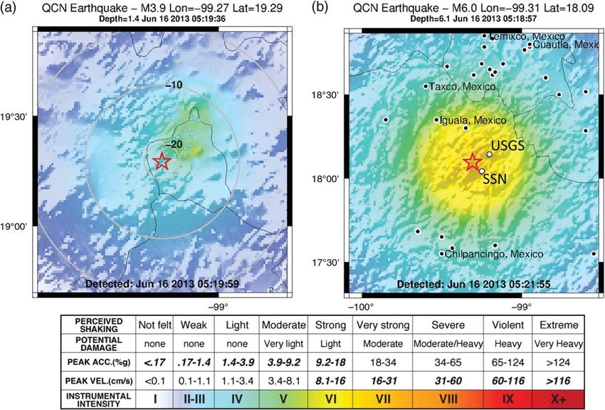
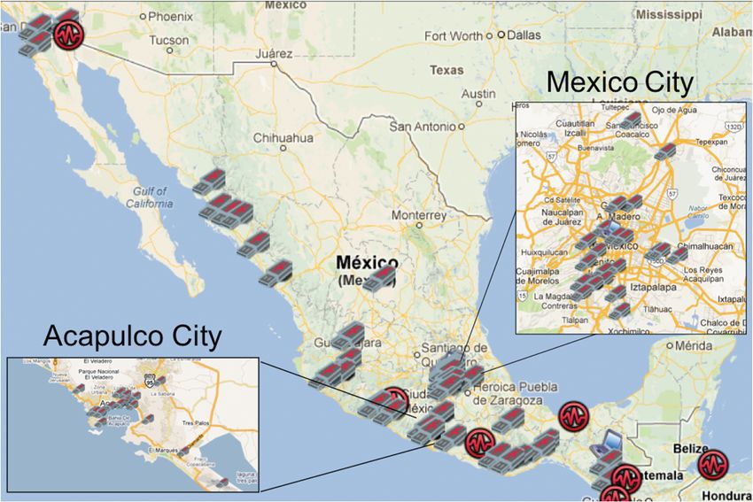
▴ Figure 1. Distribution of sensors in Mexico (April 2013). USB-like icons indicate external sensors. Laptop-like icons show internal
                  sensors. Circles correspond to earthquakes M w > 3:5 as reported by the U.S. Geological Survey (USGS).

                  main campus of the Autonomous National University of                                    sensors provide a larger detection range, increasing the earth-
                  Mexico in Mexico City to provide redundancies to the system                             quake detectability in areas of low sensor density and for small
                  and allow independent testing of the algorithms.                                        earthquakes (M w < 4:0). Sensors have been installed mostly at
                       Sensors operate under either trigger or continuous mode.                           public institutions, namely schools, colleges, governmental
                  In the trigger mode, the sensor data are saved in a small ring                          offices, and hospitals. Installation at public institutions seeks to
                  buffer until the STLA algorithm declares a trigger. The host                            foster understanding of seismology among the general public
                  computer then transmits a package of information to the server                          and students in addition to providing a reliable Internet con-
                  with the sensor identification information (sensor id, latitude                         nection during working hours. In some cases, local businesses
                  and longitude, type of sensor) and the trigger data (trigger time                       such as hotels and resorts were included in the program given
                  and maximum peak ground acceleration for four consecutive 1 s                           their proximity to the Pacific coast. The majority of these sites
                  time windows). Sensors operating in continuous mode locally                             have been chosen through scouting trips along the Pacific
                  record ground motions in 10 min intervals, and the waveforms                            Coast of Mexico and electronic requests made by members
                  are transferred periodically to the central server. Continuous                          of the public through the RAS website.
                  mode allows recording for uninterrupted collection of the data                                For better performance of the array, sensors are fixed perma-
                  that can be used for building response analysis (Kohler et al.,                         nently to the ground with either epoxy or instant glue and then
                  2013) and non-real-time studies (Cochran et al., 2011). Figure 3                        covered with a translucent acrylic box. This simple setup reduces
                  shows the latency times for the RAS array in comparison with the                        false triggers caused by accidental bumps and enhanced the par-
                  latency times observed worldwide by QCN project. In Mexico,                             ticipant engagement in project in comparison to simply taping
                  90% of the trigger data reach the central computer within 8.1 s.                        the sensor to the ground as was done at the start of the project.
                  Although in Mexico there is some delay in the transmission of
                  the data due to slower Internet connections, it does not signifi-                       SEISMIC RISK
                  cantly affect the performance of the system.
                       The RAS consists mainly of 16-bit O-Navi sensors and a                             Mexico is located at the southern edge of the North American
                  smaller number of 12- or 14-bit Joy Warrior sensors. 16-bit                             plate where it collides with the Cocos and Caribbean plates.

                                                                                         Seismological Research Letters    Volume 86, Number 3 May/June 2015              849

Downloaded from http://pubs.geoscienceworld.org/ssa/srl/article-pdf/86/3/848/2771997/848.pdf
by California Inst of Technology user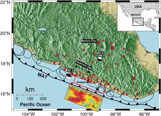
1

                                                                                                    0.9

                                                                                                    0.8

                                                                                                    0.7

                                                                                                    0.6

                                                                                                    0.5

                                                                                                    0.4

                                                                                                    0.3

                                                                                                    0.2

                                                                                                    0.1

             ▴   Figure 2. Map of simulated Red Atrapa Sismos (RAS) stations                         0
                                                                                                          0       2          4           6           8          10
             (red squares) for the hypothetical M w 8.2 earthquake rupture along
             the Guerrero Gap. The red box shows the rupture slip (shown offset
             from the box) used for the synthetic scenario (Pérez-Campos et al.,                ▴  Figure 3. Latency of the RAS array compared with the latency
             2013). The white star marks the epicenter obtained by the inversion,               observed globally by the QCN.
             whereas the black star indicates the location used in the compu-
             tation of the synthetic seismograms. Focal mechanisms correspond
             to the epicentral location of the M w 7.2 Papanoa and the M w 5.9
                                                                                                 Singh, 1992; Kanamori et al., 1993). The resonance of the ba-
             Huitzuco earthquakes. Polygons indicate the location of the major
                                                                                                 sin caused the collapse of hundreds of 7–14 story buildings
             ruptures in Mexico in the past 100 years (Kostoglodov and Pacheco,
                                                                                                 including modern apartment complexes and major hospitals.
             1999). MAT, Middle America trench.
                                                                                                       Although large megathrust earthquakes have been histor-
                                                                                                 ically considered the major seismic risk, intraslab earthquakes at
             The subduction rate of the Cocos plate is between                                   the northern end of the subducted Cocos plate poses an in-
             ∼50–100 mm=yr along the Pacific coast of Mexico, whereas                            creasing concern in the estimation of seismic hazard in central
             the Caribbean plate slips near the southern border with Gua-                        Mexico (Singh et al., 2014). Garcia et al. (2005) shows that
             temala and Belize at a rate of 20 mm=yr. Therefore, seismic                         intraslab earthquakes produce high peak ground accelerations
             potential for damaging megathrust earthquakes along the                             due to a larger stress drop in comparison with interplate events.
             Pacific coast increases from the southern border with Guate-                        Response spectra for interplate earthquakes as recorded in
             mala up to the triple junction between the Rivera, Cocos, and                       Mexico City show higher amplitudes in the 0.1–2 Hz fre-
             North America plate. Figure 2 shows the rupture zones from                          quency range, whereas recordings from intraslab events are do-
             some of the largest earthquakes recorded during the past 100                        minated by higher frequencies, f > 2:5 Hz (Singh et al., 2013).
             years and the location of the earthquakes analyzed in this study.                   Some consequences of the difference in the spectral amplitudes
             Notice the segment of the trench, known as the Guerrero Gap,                        suggest that intraslab events represent a major risk for low-rise
             where no large earthquakes have been reported at least since the                    buildings (< 4 story) in comparison with the farther interplate
             first decade of the twentieth century. This segment is also at                      events. These two types of events have now been recorded by
             the shortest distance between the seismogenic zone and Mexico                       the RAS array as discussed below.
             City posing a potentially elevated risk for the Mexican capital.
                   Population density in Mexico is mainly concentrated inland                    16 JUNE 2013 M w 5.9 EARTHQUAKE
             around the Mexico City area (∼20 million people), although
             some important cities exist along the coast, such as Acapulco,                      On 16 June 2013, a moderate intraslab normal-faulting earth-
             Mazatlan, Puerto Vallarta, and so on. Nonetheless, ground mo-                       quake ruptured 112 km south of Mexico City with a magni-
             tions are highly amplified at regional distances as dramatically                    tude of M w 5.9 as reported by the SSN. This earthquake is one
             demonstrated during the 1985 M w 8.1 Michoacán earthquake                           of the closest such events to Mexico City ever recorded. The
             (Campillo et al., 1989). Human and economic losses from this                        broadband CU station, located at the Universidad Nacional
             earthquake still remain as the most devastating natural catastro-                   Autónoma de México (UNAM)-Institute of Geophysics,
             phe in the history of Mexico. The earthquake, located on the                        recorded the second largest peak ground acceleration
             Pacific Coast > 400 km southwest from the capital, caused seis-                     (19.2 Gal) in the last 50 years, exceeded only by the cata-
             mic waves with dominant frequency that were trapped and am-                         strophic 1985 earthquake (Singh et al., 2014). Intensities in
             plified within the Mexico City basin (Anderson et al., 1986;                        the city were comparable with the intensities generated by
             Sánchez-Sesma et al., 1988; Singh et al., 1988; Ordaz and                           larger (M w > 7:0) thrust earthquakes along the subduction in-

              850     Seismological Research Letters                     Volume 86, Number 3   May/June 2015

Downloaded from http://pubs.geoscienceworld.org/ssa/srl/article-pdf/86/3/848/2771997/848.pdf
by California Inst of Technology user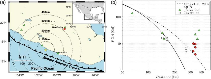
18 APRIL 2014 M w 7.2 PAPANOA EARTHQUAKE
                                                                                                          The 18 April 2014 M w 7.2 Papanoa earthquake ranks among
                                                                                                          the largest earthquakes recorded by the RAS array. It ruptured a
                                                                                                          segment of the Pacific trench, just northwest of the Guerrero
                                                                                                          Gap. The event caused moderate damage in the epicentral area
                                                                                                          and in Mexico City due to amplification of the seismic waves
                                                                                                          in the sedimentary basin that underlies the city. The Mexican
                                                                                                          earthquake early warning system successfully triggered an alarm
                                                                                                          in Mexico City, 68 s before the surface waves reached the
                                                                                                          capital. The event occurred during a major holiday in Mexico,
                                                                                                          Good Friday, which caused many of the computers located at
                                                                                                          schools and public offices to be out of service at the time of the
                                                                                                          earthquake. However, a sufficient number of sensors were ac-
                                                                                                          tive at regional distances and in Mexico City. The occurrence
                                                                                                          of the event under these circumstances provided an excellent
                                                                                                          opportunity to test the RAS array under a low level of volun-
                  ▴ Figure 4. Attenuation law for intraslab earthquakes in central                        teer participation. Despite the sparseness of the network, the
                  Mexico. Crosses show the Amax from the RAS sensors, and circles
                                                                                                          system successfully estimated the magnitude and location.
                  show the National Seismic Network sensors.
                                                                                                          Nonetheless, a maximum correlation distance of 400 km was
                                                                                                          required to overcome the lack of near-epicenter sensors. Figure 6a
                  terface. Ground shaking was widely described by the popula-                             shows the location of the sensors used in the inversion of the
                  tion as extremely strong. Figure 4 shows a comparison between                           data and all sensors that reported waveform data to the RAS
                             p                                server hours after the event. Because of the large distance be-
                  the Amax ( PGA2NS  PGA2EW =2) recordings of the RAS ar-
                                                                                                          tween the source and many of the sensors, it took a significant
                  ray and the Amax accelerations recorded by the SSN local net-
                                                                                                          amount of time (over a minute) for the system to issue an initial
                  work. Performance of RAS sensors is consistent with that of the                         location and magnitude for the event. However, the event dem-
                  SSN instruments. The solid line indicates the attenuation law                           onstrated a robust detection for a 100 km sparse network.
                  for intraslab events obtained using a historical dataset (Garcia                             Figure 6b shows the maximum peak ground accelerations
                  et al., 2005). This type of earthquake shows larger stress drops                        for the sensors used in the inversion of the data. Remarkably,
                  and amplitudes at high frequencies in comparison with intra-                            data reported from the sensors located in the state of Colima
                  crust earthquakes with similar magnitudes in this area (Singh                           and in Ciudad Guzman, Jalisco, ∼350 km northwest of the
                  et al., 2013).                                                                          epicenter; roughly at the same distance as Mexico City, show
                        At the time of the earthquake, most of the active sensors                         accelerations that exceed the peak accelerations in Mexico City
                  happened to be in the lake-bed zone of Mexico City. The re-                             basin. Data from these sensors were not used in the original
                  sulting ShakeMap was released automatically 33 s after the                              earthquake location due to the correlation distance limitation
                  earthquake, Figure 5a shows the ShakeMap obtained using the                             in the location algorithm. However, large acceleration records
                  RAS network. Higher seismic intensities correlate well with the                         show evidence of possible zones where seismic hazard may be
                  areas where amplified peak ground accelerations are expected                            underestimated due to the lack of seismic instrumentation.
                  due to the low-velocity properties of the near-surface soil.
                  However, the resulting location and magnitude were not well
                  constrained. The original algorithm used a 200 km correlation
                                                                                                          MAGNITUDE 8.2 EARTHQUAKE SCENARIO
                  distance for the triggers. A posteriori examination of the results
                                                                                                          The Guerrero Gap is a segment of the subduction zone along
                  showed that the limiting distance was not sufficiently large to
                                                                                                          the Pacific Coast of Mexico well known for the lack of large
                  provide an accurate estimate of the epicenter location and con-                         ruptures in the past 100 years. It is believed to be the highest
                  sequently its magnitude. The detection algorithms were origi-                           seismic risk segment in Mexico with the potential to produce
                  nally developed using relatively small source–station distances                         an earthquake with a magnitude at least as high as M w 8.1. The
                  (10–100 km) and small events (M w ∼ 4–5) (e.g., Chung et al.,                           rupture zone is ∼100 km closer to Mexico City than the dam-
                  2011; Lawrence et al., 2014). Thus, the performance was poor                            aging 1985 Michoacán earthquake, thereby it may induce
                  for the source–station distributions for this event. Figure 5b                          ground motions in the Mexico City basin with amplitudes
                  shows the revised ShakeMap obtained by rerunning the event                              2 or 3 times larger than those observed in 1985 for periods
                  retrospectively, using a maximum correlation distance between                           shorter than 2 s (Kanamori et al., 1993). Furthermore, the port
                  triggered sensors of 400 km. As a result, the accuracy in the                           city of Acapulco, one of the main resort cities and commercial
                  location of the event significantly improved to within a few                            hubs of Mexico, lies on the edge of the seismic gap where large
                  kilometers from the location provided by the SSN and reported                           economic and human losses are expected in case of a rupture of
                  by the U.S. Geological Survey (USGS).                                                   this segment.

                                                                                         Seismological Research Letters   Volume 86, Number 3 May/June 2015             851

Downloaded from http://pubs.geoscienceworld.org/ssa/srl/article-pdf/86/3/848/2771997/848.pdf
by California Inst of Technology user
▴ Figure 5. (a) ShakeMap released by the RAS shortly after the 16 June 2013 M w 5.9 earthquake. (b) Revised map obtained using an
offline version of the code, showing an accurate location and magnitude of the event. Red star indicates estimated event epicenter, and
colors indicate estimated peak shaking intensities. Empty circles show the locations reported by the SSN and the USGS, respectively.
▴ Figure 6. (a) Distribution of reported triggers from the RAS array for the M w 7.2 Papanoa earthquake. Red circles indicate the triggers
used in the magnitude and location estimation, these sensors provide the best-fitting data. White circles show triggers outside the Mexico
City basin. Triangles show triggers retrieved by the system after the earthquake but not used in the inversion of the data. (b) Maximum
peak ground acceleration recordings as a function of distance to the epicenter. Solid lines indicate the attenuation law for magnitude 7.2
earthquakes. Symbols and color coding are the same as in (a).
852 Seismological Research Letters Volume 86, Number 3 May/June 2015
Downloaded from http://pubs.geoscienceworld.org/ssa/srl/article-pdf/86/3/848/2771997/848.pdf
by California Inst of Technology user▴ Figure 7. Vertical-component simulated traces for an M w 8.2
scenario. White noise was added to each of the traces to count
on the electronic noise of the sensors.
▴ Figure 8. Performance of the array for the M w 8.2 scenario.
Following Cruz-Atienza et al. (2011), we generated syn- Red Lines indicate the theoretical latitude, longitude, depth,
thetic seismograms to test the response of the RAS array for and magnitude used for the computation of the synthetic scenario.
an M w 8.2 scenario earthquake with these features by means T Det is the difference between the calculated earthquake time and
of a parallel finite-difference code (Olsen et al., 2009) in a the hypothetical start time of the earthquake. The % detection
heterogeneous crustal model (Iglesias et al., 2010). The fault shows the probability at which a randomly selected set of N sta-
area is 84 km long and 42 km wide and has a final-slip distri- tions yields a detection.
bution stochastically generated using a spatial random field
modulated by a von Karman autocorrelation function. Local Figure 8 summarizes the results of the test. The percentage
rupture velocities (i.e., source rupture times) are variable and of detections is the minimum number of stations needed for
were determined as a function of local final slips with respect to the system to correlate the incoming triggers as a possible
a mean value of 2:8 km=s. Slip rate time histories are the dy- event. In this case, the maximum correlation distance among
namic-rupture consistent Yoffe functionals introduced by sensor is set to 400 km to include triggers in areas such as
Tinti et al. (2005). The hypocenter was fixed at 16.307° N, Mexico City, where the sensor density is greater and strong
−99:240° W, and 7 km depth. There is an average slip on the shaking is expected. The rate of detection increases linearly
fault of 2.0 m and a maximum of 4.5 m. Details on the source as the number of N active sensors that trigger during the earth-
generation can be found in Pérez-Campos et al. (2013). quake increases from a minimum of 5 sensors up to approx-
We examine the simulated data from 93 stations, which imately 15 sensors; if more than 15 sensors record an event
correspond to the current configuration of the National Seis- then the percentage of events detected is essentially 100%.
mic Network and the Mexico City Strong Motion Array. Fig- Magnitude estimates fit well within one standard deviation
ure 2 shows the distribution of stations used in the synthetic from the theoretical value of M w 8.2 simulation. On the other
model. White noise is added to each of the sensors to account hand, the hypocentral location of the event is shifted from the
for electronic noise and random perturbations. Figure 7 shows original position as a consequence of the large dimensions of
the simulated vertical component of the seismic traces gener- the rupture. Latitude is generally well resolved within less than
ated. The data are fed into an offline version of the QCN soft- one standard deviation, even with a small number of sensors.
ware, which produces a hypothetical ShakeMap and location. However, the longitude estimate is biased northward of the
Network delays are also included in the simulations based on scenario epicenter, likely due to the fact that no sensors are
the trigger time information collected during the past two years located south of the rupture area. Depth is overestimated by
(Lawrence et al., 2014). the location algorithm, which provides a mean depth of the
To test the possible outcome of the system in the event of rupture. The value of T dec indicates the difference between
a large rupture, we randomly select a subset of N stations from the theoretical start of the earthquake and the time to obtain
the original data set to emulate the fluctuations of the active an initial solution to the inversion algorithm. On average, the
sensors in the network. The RAS array depends heavily on the system reports the origin time of the earthquake ∼15 s after
volunteer participation to keep their computers powered on the actual time as a consequence of the error in the latitude and
and connected to the Internet. Additional misses may be caused depth estimate.
by power and Internet disruption due to intense shaking near A major challenge in the accuracy of the algorithms lies in
the epicentral area. By selecting an assemblage of 100 sets of N the fact that predicted peak ground accelerations in Mexico
stations, we obtain a statistical test of the performance of the City (and possibly other areas) greatly exceed predicted values
array as a function of the number of active sensors. by standard attenuation laws. The select simulation does not
Seismological Research Letters Volume 86, Number 3 May/June 2015 853
Downloaded from http://pubs.geoscienceworld.org/ssa/srl/article-pdf/86/3/848/2771997/848.pdf
by California Inst of Technology userinclude such an effect, but it does provide a metric for the ex- a new opportunity to analyze site effects in areas of the country
pected outcome for a large earthquake scenario. with no traditional seismic instrumentation due to lack of in-
frastructure and economic relevance for the country. Monitor-
ing site effects plays an important role in understanding the
DISCUSSION AND CONCLUSIONS propagation of seismic waves and for the correct design of
the construction codes.
The RAS is a strong-motion seismic network that has rapidly
grown in Mexico in the last few years. Unlike other strong-motion
networks, the RAS array fully streams real-time data through the ACKNOWLEDGMENTS
Internet and produces online intensity ShakeMaps within a few
seconds of an earthquake. The capabilities of the system are found The authors would like to thank Susan Hough, Rob Graves,
through an examination of the performance of the network dur- Raul Valenzuela Wong, and an anonymous reviewer for their
ing M w 5.9 and M w 7.2 earthquakes that occurred in the past two valuable comments and suggestions that significantly improved
years and an expected M w 8.2 scenario. the manuscript. Furthermore, we want to thank dozens of vol-
The intraslab earthquake (16 June 2013) recorded by the unteers and students that participate in the Quake-Catcher
array shows that maximum correlation distance drastically lim- Network (QCN) program in Mexico for their support and in-
its the location of the system in cases where there is poor or null valuable assistance. Installation and maintenance of the array
sensor density around the epicentral area. By increasing the was funded by the Grants PAPIIT IB101312-2, UC MEXUS-
maximum correlation threshold (from 200 to 400 km), it was CONACYT CN-09-315, and NSF EAR-1027802.
possible to improve the location and magnitude significantly
for this event. Although intraslab earthquakes are relatively in- REFERENCES
frequent in comparison with the interplate earthquakes, they
occur at closer distances to populated areas, which may pose an Anderson, D. P. (2004). BOINC: A system for public-resource comput-
underestimation of the seismic risk in Mexico City (Iglesias ing and storage rep., 5th IEEE/ACM International Workshop on
Grid Computing, Pittsburgh, Pennsylvania, 8 November 2004.
et al., 2002; Singh et al., 2013). Anderson, J. G., P. Bodin, J. N. Brune, J. Prince, S. K. Singh, R. Quaas,
The Papanoa earthquake was a powerful event that was and M. Onate (1986). Strong ground motion from the Michoacán,
recorded by a relatively small number of instruments. The Mexico, earthquake, Science 233, no. 4768, 1043–1049.
recordings from these events show significant amplification Campillo, M., J. C. Gariel, K. Aki, and F. J. Sánchez-Sesma (1989). De-
factors not only in Mexico City but also in other areas of the structive strong ground motion in Mexico City: Source, path, and
site effects during great 1985 Michoacán earthquake, Bull. Seismol.
country where seismic studies have been limited by the lack of Soc. Am. 79, no. 6, 1718–1735.
strong-motion instrumentation. Chung, A. I., C. Neighbors, A. Belmonte, M. Miller, H. H. Sepulveda, C.
The numerical simulation shows the possible outcome for Christensen, R. S. Jakka, E. S. Cochran, and J. F. Lawrence (2011).
a large earthquake (M w > 7:5) the recurrence time of which is The Quake-Catcher Network rapid aftershock mobilization pro-
∼30 years (Iglesias et al., 2002). For the magnitude M w 8.2 gram following the 2010 M 8.8 Maule, Chile earthquake, Seismol.
Res. Lett. 82, no. 4, 526–532.
scenario, the expected ground motions and location are accu- Clayton, R., T. Heaton, M. Chandy, A. Krause, M. Kohler, J. Bunn, R.
rately predicted by an offline version of the code. Although the Guy, M. Olson, M. Faulkner, M.-H. Cheng, L. Strand, R. Chandy,
location of the onset (epicenter) of the rupture was not prop- D. Obenshain, A. Liu, and M. Aivazis (2011). Community Seismic
erly resolved, it lay within the rupture zone. The response of Network, Ann. Geophys. 54, no. 6, doi: 10.4401/ag-5269.
the array shows promising capabilities for detecting a damaging Cochran, E. S., J. F. Lawrence, C. Christensen, and A. Chung (2009). A
novel strong motion seismic network for community participation
earthquake using a sparse network with spacing between sen- in earthquake monitoring, IEEE Instrum. Meas. Mag. 12, 8–15.
sors of even hundreds of kilometers. Cochran, E. S., J. F. Lawrence, C. Christensen, and R. Jakka (2009). The
Performing a quick characterization of strong-motion ac- Quake-Catcher Network: Citizen science expanding seismic hori-
celerations can contribute to an efficient emergency response zons, Seismol. Res. Lett. 80, 26–30.
in the event of a major earthquake in Mexico. In particular, the Cochran, E. S., J. F. Lawrence, A. Kaiser, B. Fry, A. Chung, and C. Chris-
tensen (2011). Comparison between low-cost and traditional MEMS
deployment of a low-cost, real-time seismic network shows an accelerometers: A case study from the M 7.1 Darfield, New Zealand,
important advance of the seismic monitoring capabilities of aftershock deployment, Ann. Geophys. 54, no. 6, 728–737.
Mexico. Evaluation of the current algorithms shows the present Cruz-Atienza, V. M., V. Hjörleifsdóttir, and A. Rocher (2011). Simu-
configuration of instruments can produce reliable ShakeMaps lando un M 8.2 en la brecha de Guerrero, Reunión Anual 2011,
in short periods of time. In addition, we observed that site ef- Unión Geofísica Mexicana, GEOS 31, 150.
Earle, P. S., and P. M. Shearer (1994). Characterization of global seismo-
fects do not significantly influence the location and magnitude grams using an automatic picking algorithm, Bull. Seismol. Soc. Am.
estimation of events. Testing of the system using numerical 84, 366–376.
simulation suggests a robust performance for large and damaging Evans, J. R., R. M. Allen, A. I. Chung, E. S. Cochran, R. Guy, M. Hell-
earthquakes. Bias in the time and location estimates comes from weg, and J. F. Lawrence (2014). Performance of several low-cost ac-
complexity of the source and an irregular distribution of sensors. celerometers, Seismol. Res. Lett. 85, no. 1, 147–158.
Garcia, D., S. K. Singh, M. Herráiz, M. A. Ordaz, and J. Pacheco (2005).
Although site effects in Mexico City are well known, and Inslab earthquakes of Central Mexico: Peak ground-motion param-
widely studied, large amplification factors may exist in other eters and response spectra, Bull. Seismol. Soc. Am. 95, no. 6, 2272–
areas that are currently undocumented. The RAS arrays open 2282.
854 Seismological Research Letters Volume 86, Number 3 May/June 2015
Downloaded from http://pubs.geoscienceworld.org/ssa/srl/article-pdf/86/3/848/2771997/848.pdf
by California Inst of Technology userIglesias, A., R. W. Clayton, X. Pérez-Campos, S. K. Singh, J. F. Pacheco, A study of amplification of seismic waves in the valley of
D. García, and C. Valdés-González (2010). S wave velocity structure Mexico with respect to a hill zone site, Earthq. Spectra 4, no. 4,
below central Mexico using high-resolution surface wave tomogra- 653–673.
phy, J. Geophys. Res. 115, no. B06307, doi: 10.1029/2009JB006332. Singh, S. K., M. Ordaz, X. Pérez-Campos, and A. Iglesias (2013). Intra-
Iglesias, A., S. K. Singh, J. F. Pacheco, and M. Ordaz (2002). A source and slab versus interplate earthquakes as recorded in Mexico City:
wave propagation study of the Copalillo, Mexico earthquake of 21 Implications for seismic hazard, Earthq. Spectra, doi: 10.1193/
July, 2000 (M w 5:9): Implications for seismic hazard in Mexico 110612EQS324M.
City from inslab earthquakes, Bull. Seismol. Soc. Am. 92, 885–895. Singh, S. K., X. Pérez-Campos, V. H. Espíndola, V. M. Cruz-Atienza, and
Kanamori, H., P. C. Jennings, S. K. Singh, and L. Astiz (1993). Estima- A. Iglesias (2014). Intraslab earthquake of 16 June 2013 (M w 5.9),
tion of strong ground motions in Mexico City expected for large one of the closest such events to Mexico City, Seismol. Res. Lett. 85,
earthquakes in The Guerrero Seismic Gap, Bull. Seismol. Soc. no. 2, 268–277.
Am. 83, no. 3, 811–829. Tinti, E., E. Fukuyama, A. Piatanesi, and M. Cocco (2005). A kinematic
Kohler, M. D., T. H. Heaton, and M. H. Cheng (2013). The Community source-time function compatible with earthquake dynamics, Bull.
Seismic Network and Quake-Catcher Network: Enabling structural Seismol. Soc. Am. 95, no. 4, 1211–1223, doi: 10.1785/0120040177.
health monitoring through instrumentation by community partic-
ipants, in Sensors and Smart Structures Technologies for Civil, Luis A. Dominguez
Mechanical, and Aerospace Systems 2013, J. P. Lynch, C-B. Yun,
and K-W. Wang (Editors), Proc. of SPIE, Vol. 8692, 86923X. National School for Professional Studies
Kostoglodov, V., and J. F. Pacheco (1999). Cien años de sismicidad en Campus Morelia, UNAM
México, http://usuarios.geofisica.unam.mx/vladimir/sismos/100a% Antigua Carretera a Patzcuaro No. 8701
F1os.html (last accessed December 2014). Colonia Ex-Hacienda de San Jose de la Huerta
Lawrence, J. F., E. S. Cochran, A. Chung, A. Kaiser, C. M. Christensen, C.P. 58190 Michoacán, México
R. Allen, and M. Taufer (2014). Rapid earthquake characterization
using MEMS accelerometers and volunteer hosts following the ladominguez@geofisica.unam.mx
M 7.2 Darfield, New Zealand, earthquake, Bull. Seismol. Soc.
Am. 104, no. 1, 184–192. Battalgazi Yildirim
Liang, W., W. Lee, K. H. Chen, E. H. Yen, J. F. Lawrence, C. Lin, and C. Jesse F. Lawrence
Chang (2013). Extracting the building response with QCN-Taiwan Stanford University
sensor data: Application to the building of Science Education
Center, National Taiwan Normal University, in AGU Fall Meeting 397 Panama Mall
Abstracts, San Francisco, California, Vol. 1, 2415. Mitchell Building 360
Olsen, K. B., S. M. Day, L. A. Dalguer, J. Mayhew, Y. Cui, J. Zhu, V. M. Stanford, California 94305-2215 U.S.A.
Cruz-Atienza, D. Roten, P. Maechling, T. H. Jordan, D. Okaya, and
A. Chourasia (2009). ShakeOut-D: Ground motion estimates using Allen L. Husker
an ensemble of large earthquakes on the southern San Andreas fault
with spontaneous rupture propagation, Geophys. Res. Lett. 36, Carl Christensen
L04303, doi: 10.1029/2008GL036832. Victor M. Cruz-Atienza
Ordaz, M., and S. K. Singh (1992). Source spectra and spectral attenu- Instituto de Geofísica, UNAM
ation of seismic waves from Mexican earthquakes, and evidence of Circuito de la Investigación Científica s/n
amplification in the hill zone of Mexico City, Bull. Seismol. Soc. Am. Ciudad Universitaria, Delegación Coyoacán
82, no. 1, 24–43.
Pérez-Campos, X., D. Melgar, S. K. Singh, V. Cruz-Atienza, A. Iglesias, C.P. 04510, México D.F.
and V. Hjörleifsdóttir (2013). Rapid estimation of fault parameters
for tsunami warning along the Mexican subduction zone: A sce- Elizabeth Cochran
nario earthquake in the Guerrero Seismic Gap, Seismol. Res. Lett. U.S. Geological Survey
84, no. 3, 474–484. 525 & 535 South Wilson Street
Sánchez-Sesma, F., S. Chavez-Perez, M. Suarez, M. A. Bravo, and L. E.
Perez-Rocha (1988). Mexico earthquake of September 19, 1985— Pasadena, California 91106-3212 U.S.A.
On the seismic response of the valley of Mexico, Earthq. Spectra 4,
no. 3, 569–589. Published Online 11 March 2015
Singh, S. K., J. Lermo, T. Dominguez, M. Ordaz, J. M. Espinosa, E. Mena,
and R. Quaas (1988). Mexico earthquake of September 19, 1985—
Seismological Research Letters Volume 86, Number 3 May/June 2015 855
Downloaded from http://pubs.geoscienceworld.org/ssa/srl/article-pdf/86/3/848/2771997/848.pdf
by California Inst of Technology userYou can also read