AUSTRALIAN SEASONAL BUSHFIRE OUTLOOK: DECEMBER 2019 - Bushfire & Natural ...
←
→
Page content transcription
If your browser does not render page correctly, please read the page content below
ISSUE 68 DECEMBER 2019
TOPICS IN THIS EDITION | FIRE IMPACTS | FIRE SEVERITY | FIRE WEATHER
AUSTRALIAN SEASONAL BUSHFIRE
OUTLOOK: DECEMBER 2019
OVERVIEW
The 2019/20 fire season is well underway
with multiple large bushfires occurring
since the release of the previous Outlook in
August. Queensland and New South Wales in
particular have experienced severe fires, but
all states have had challenging fire conditions.
Catastrophic fire danger ratings have been
issued in NSW, Western Australia, South
Australia and Victoria, and there has been loss
of human lives and animals, and damage to
property and the environment.
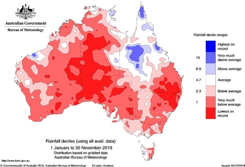
2019 has seen the second warmest January
to November period on record for Australia,
0.01°C behind 2013, coupled with the second-
driest on record for the same period. Looking
forward into the Outlook period, it is these Above normal fire potential
conditions that lead to the continued above Normal fire potential
normal fire potential across most states and
territories into 2020. A long and challenging
Figure 1: AUSTRALIAN SEASONAL BUSHFIRE OUTLOOK DECEMBER 2019. AREAS ARE BASED ON THE INTERIM
fire season is expected, and all states and the BIOGEOGRAPHIC REGIONALISATION FOR AUSTRALIA AND OTHER GEOGRAPHICAL FEATURES.
ACT are warning of increased fire danger as
the fire season progresses. Services and Department of Biodiversity, eastern Tasmania, south western WA, north
This December 2019 Australian Seasonal Conservation and Attractions Western western Australia and parts of eastern Victoria
Bushfire Outlook covers all states and Australia, and Bushfires NT. on a range of timescales. Areas of above
territories through summer 2019/20. It average rainfall are largely confined to central
provides information to assist fire authorities RECENT CONDITIONS Queensland, extending to the coast where
in making strategic decisions such as resource Seasonal fire conditions are a function of heavy rainfall occurred early in the year.
planning and prescribed fire management to fuel amount and state, and seasonal weather Some areas, such as NSW extending into
reduce the negative impacts of bushfire. conditions. The year to date has been south eastern Queensland, are into their third
Bushfire potential depends on many factors. unusually warm and dry for large parts of year of dry conditions. It will take a prolonged
The volume, location and timing of rainfall Australia (Figures 2 and 3, page 2), with many period of above average rainfall to remove
are critically important when estimating records set. the deficiencies which are in place, meaning
vegetation (fuel) volumes and growth. The For January to November, rainfall has been that general landscape dryness is likely to
climate outlook for the next few months is below to very much below average over much persist for many areas for some months. The
also a crucial factor. of Australia. It has been the second-driest combination of severe dry conditions over
The Australian Seasonal Bushfire Outlook: January to November on record for Australia the long and short-term, coupled with high
December 2019 is developed by the Bushfire (rainfall records begin in 1900), and the driest temperatures and record low humidity have
and Natural Hazards CRC, AFAC, the since the peak of the Federation Drought contributed to the dangerous start to the
Bureau of Meteorology, Queensland Fire in 1902. It has been especially dry over the southern fire season.
and Emergency Services, the New South southern half of Australia (south of the The warming trend means that above
Wales Rural Fire Service, ACT Emergency Northern Territory/South Australia border), average temperatures now tend to occur
Services Agency, ACT Parks and Conservation which had the driest January to November in most years, and 2019 has followed this
Service, Country Fire Authority, Department period on record. At a state level, rainfall pattern. Temperatures in Australia for January
of Environment, Land, Water and Planning deficiencies affect large areas, especially to November have been the second warmest
Victoria, Tasmania Fire Service, Country Fire south eastern Queensland through eastern on record (1.37 °C above the 1961–1990
Service, Department of Fire and Emergency New South Wales, the ACT, South Australia, average, behind 1.38 °C for the same period
| All Hazard Notes are available at www.bnhcrc.com.au/hazardnotes 1
Figure 2: RAINFALL DECILES FOR JANUARY TO NOVEMBER 2019 SHOWING DRY                 Figure 3: MAXIMUM TEMPERATURE DECILES FOR JANUARY TO NOVEMBER 2019
       CONDITIONS OVER MUCH OF AUSTRALIA.                                                  SHOWING WARM CONDITIONS ACROSS AUSTRALIA.

                                                           cool season rainfall and rising temperatures          across long fetches of land, this air becomes
       DEFINITIONS                                         (see State of the Climate 2018). Fire season          dry and hot with reduced rainfall.
       Bushfire potential: The chance of a fire            severity is increasing across much of Australia         While both climate drivers are likely to
       or number of fires occurring of such                as measured by annual (July to June) indices          decay by mid-summer, their legacy will take
       size, complexity or other impact (such              of the FFDI, with the increases tending to be         some time to fade. The positive Indian Ocean
       as biodiversity or global emissions)                greatest in inland eastern Australia and coastal      Dipole and the dry conditions experienced in
       that requires resources (from both                  Western Australia.                                    winter and spring are known to be associated
       a pre-emptive management and                                                                              with a more severe fire season for south east
       suppression capability) beyond the                  CLIMATE OUTLOOK                                       Australia in the subsequent summer.
       area in which it or they originate. Fire            The climate outlook for summer is mainly                The rainfall outlook for January to March
       potential depends on many factors                   influenced by the Indian Ocean, together              (Figure 4, page 3) suggests that rainfall is
       including weather and climate, fuel                 with other factors including long-term trends.        likely to be above average in western areas,
       abundance and availability, recent                  Ocean temperatures in the tropical Pacific            while eastern Australia generally sees odds
       fire history and firefighting resources             remain close to average, with El Niño or La           which are close to 50:50. The decay of the
       available in an area.                               Niña unlikely to develop in the coming months.        Indian Ocean Dipole means that probability
                                                             The positive Indian Ocean Dipole pattern            swings are less strong than earlier in the
                                                           which has brought dry conditions to Australia         season for eastern areas, suggesting that
    in 2013), with daytime temperatures clearly            in recent months is forecast to decay by mid-         some relief in dry conditions is possible in the
    the warmest on record (1.9 °C above 1961-              summer. Temperatures in Australia for January         coming months.
    1990 average, temperature records begin                to November have been the second warmest                Historical outlook accuracy for January
    1910). These high temperatures add to the              on record (1.37 °C above the 1961–1990                to March is moderate across western and
    impact of reduced rainfall by increasing               average, behind 1.38°C for the same period in         southern mainland Australia, as well as the
    evaporation, further drying the landscape and          2013), with daytime temperatures clearly the          northern NT and northern Queensland.
    vegetation. However, it should be noted that           warmest on record (1.90 °C above 1961-1990            Elsewhere, accuracy is low to very low.
    poor growth of grass and annual plants means           average, temperature records begin 1910).               The outlook for January to March maximum
    that vegetation loads are reduced in many              Usually Indian Ocean Dipole events break              temperature outlook (Figure 5, page 3) favours
    drought-affected areas. Dust storms may be a           down at the end of spring or early summer             above average daytime temperatures for
    common occurrence.                                     with the arrival of the monsoon into the              nearly all of Australia, exceeding 80 per cent
      With the combined hot and dry conditions             southern hemisphere. However, this year the           across much of the eastern half of the country.
    in place it is not surprising that the southern        monsoon has been slow to move south—in                The outlook for minimum temperatures (not
    fire season started early and has been severe          fact it was the latest retreat on record from         shown) also strongly favours above average
    to date. Large areas have seen record fire             India—and international climate models                temperatures across much of Australia,
    danger overall, as well as a very early start to       suggest the positive Indian Ocean Dipole is           excluding the south east. Historical accuracy
    the high fire danger period. In area average           likely to last longer than usual.                     for January to March maximum temperatures
    terms, the fire weather as measured by the               The other unusually persistent climate              is moderate to high across most of Australia,
    Forest Fire Danger Index (FFDI) for spring             driver is a negative Southern Annular Mode.           but low surrounding the Great Australian Bight,
    was record high for Australia, as well as              A negative Southern Annular Mode means                and to the south of the Gulf of Carpentaria.
    all states and territories apart from South            Australia’s weather systems are further north         Minimum temperature accuracy is moderate to
    Australia (second) and Victoria.                       than usual. At this time of the year, this means      high for most of Australia, except the central
      The tendency for fire seasons to become              stronger westerly winds for Tasmania and the          NT and central to western parts of Queensland,
    more intense and fire danger to occur earlier          southern mainland. In areas where those winds         where accuracy is low to very low.
    in the season is a clear trend in Australia’s          are coming off the ocean, it’s been cooler and          Updates to climate forecasts, including
    climate, reflecting reduced and/or less reliable       wetter, but in parts where westerlies blow            forecasts of monthly, fortnightly and weekly

2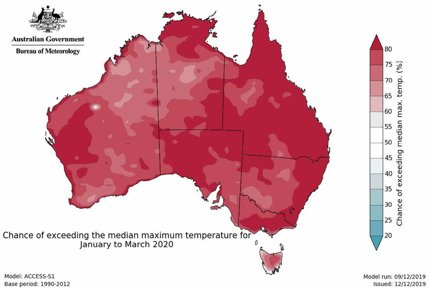
Figure 4:   CHANCE OF EXCEEDING THE MEDIAN RAINFALL FOR JANUARY TO MARCH            Figure 5: CHANCE OF EXCEEDING THE MEDIAN MAXIMUM TEMPERATURE FOR JANUARY
   2020.                                                                               TO MARCH 2020.

outlooks and the outlook for the Indian Ocean           above normal bushfire potential and will             outlooks forecasting warmer and drier than
Dipole and the El Niño-Southern Oscillation             continue to do so until these areas experience       average conditions across the state, above
will continue to be published at www.bom.gov.           significant rainfall.                                normal fire potential will continue in forested
au/climate/ahead                                          Large areas of inland Queensland have been         areas on and east of the Great Dividing Range.
                                                        drought effected since 2013, and as a result         Under these conditions, existing large fires will
REGIONAL SUMMARIES                                      there has been very little grass fuel available,     continue to remain a threat.
                                                        with the exception of sporadic and short-              West of the Divide there is minimal grass
QUEENSLAND                                              lived growth due to irregular inland rain. The       fuels available due to the drought, and as a
Following a record fire season in Queensland            Darling Downs and Granite Belt districts are         result reduced fire potential.
in 2018/2019, the 2019/2020 fire season                 continuing to face severe water shortages as
started in late August. Since then Queensland           a result of the drought. This has impacted the       ACT
has seen several intense pulses of fire weather         availability of water for fire suppression. QFES     The ACT has received less than average rainfall
affecting an already chronically dry and                continues to work closely with their partners        for nearly three years, leading to a persistent
hotter landscape, mainly in the south east -            to manage this risk. The longer the delay in         and high level of drought. The lowland forests
from Rockhampton to the NSW border and                  the arrival of the monsoon, the likelihood of        have been very dry for some time, while
extending inland to around St George.                   campaign fires in northern forest areas will         highland forests are now dry as well. This
  As this season has progressed, the drought            continue to build.                                   indicates that fuel flammability in the forests
has intensified in many areas, particularly in                                                               is high and could remain so. The forest fire risk
the south east, with the Main/Border Ranges             NEW SOUTH WALES                                      is elevated. The dry conditions and grazing by
area, and the area bounded by Warwick,                  The start to this fire season has been               farm stock and wildlife have led to lower levels
Toowoomba and the Lockyer Valley standing               unprecedented for New South Wales, with              of grass growth, resulting in reduced overall
out. These areas are showing the lowest one             large fires occurring across the state. Since        grass fire risk. On bad days grass fires may still
per cent on record for the monthly relative             July, more than 8,000 bush and grass fires           reach and impact on unprotected property.
root zone soil moisture deficit for November.           have occurred, burning over 2.8 million              This situation should persist until rains return.
The long-term, and recently more intense,               hectares. Six human lives have been lost, more       Heatwaves and dust storms may make bushfire
drought has seen significant additional surface         than 700 homes destroyed and more than               detection and suppression more challenging at
fuels (vegetation) added in forest areas                1,600 other buildings. Resources have been           times during the season.
due to stressed trees dropping significant              drawn from around NSW, other states and                The overall bushfire risk for the ACT is
amounts of branches and leaves over winter              from overseas.                                       above normal. Community members should
and spring. As a result, these areas are seeing           Much of the state has experienced very             continue to prepare for fire by taking actions
fires continuing to carry more widely and with          much below average rainfall during the last          to reduce the bushfire risks around and within
more intensity than usual, even when humidity           three months, with a small percentage of             their property and to review their bushfire
increases overnight.                                    areas in northern NSW experiencing driest            survival plans.
  Normally wet and fire-resistant rainforest            on record conditions. Long-term rainfall
and wet forests are becoming available and              deficiencies, record-low for some areas in the       VICTORIA
burning for the second season in a row,                 north of the state, have severely impacted on        The potential for above normal bushfire
with this phenomenon now extending into                 water resources.                                     activity continues across the coastal and
southern Queensland to areas such as the                  At the end of September, the NSW                   foothill forests of East Gippsland, extending
Lamington and Main Range National Parks.                Department of Primary Industries mapped              into parts of West Gippsland, Great Dividing
The rainfall deficit has also increased inland          nearly all of NSW into one of three drought          Range, and into the central Goldfields. This
of Bowen, Townsville and Cairns over the                categories - intense drought, experiencing           is due to the above average temperatures
past two months, and as a result the northern           drought or drought affected.                         and continuation of drying trends observed
forests and heavier woodlands are showing                 With the short to medium-range climate             in these regions over the last three months,

                                                                                                                                                                  3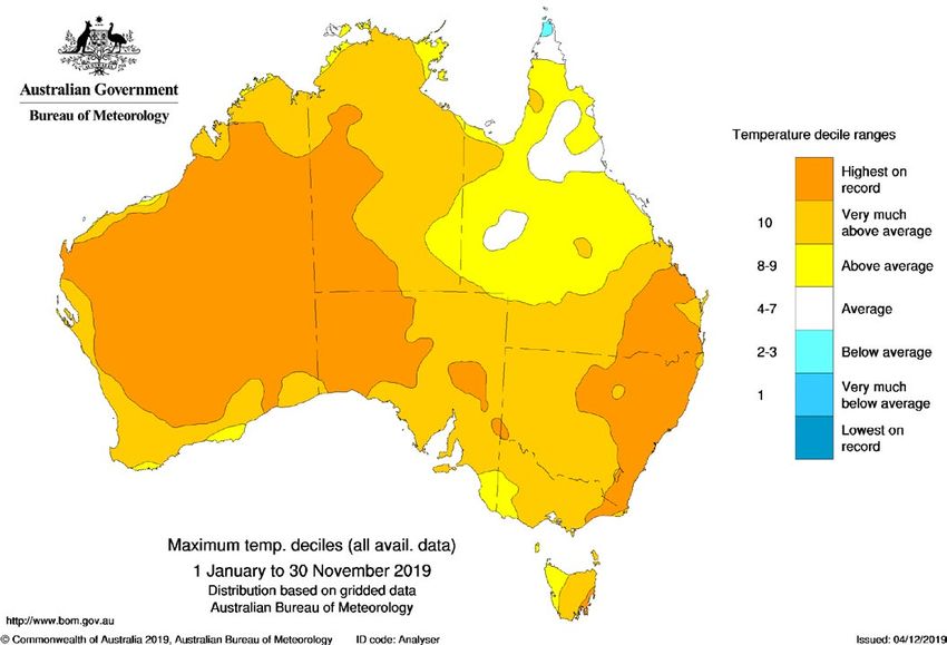
coupled with three years of significant                west for which soil moisture is less important       is impossible on the scale required.
    rainfall deficit across much of East Gippsland         than in forests.                                       The fire danger season may be prolonged
    and across the Divide. During spring, cold                                                                  across parts of South Australia. Significant
    fronts generated rainfall in southern Victoria,        SOUTH AUSTRALIA                                      bushfires have occurred in similar conditions,
    however much of inland Victoria received               Minimal rainfall, and predominately warmer           and even areas of normal fire potential can
    insufficient rainfall. In these inland areas soil      than average temperatures have persisted             expect to experience dangerous bushfires as
    moisture is lower compared to the long-term            across South Australia through spring. As a          per a normal South Australian fire season.
    average. This is likely to cause moisture stress       result, the fire danger season was brought
    on live vegetation thereby increasing the              forward, with most areas commencing two              WESTERN AUSTRALIA
    quantity of dead fuel components and result            weeks early.                                         With the positive Indian Ocean Dipole
    in higher flammability in live vegetation. Wet           The early start to the fire danger season has      delaying the onset of the monsoon, high
    forests (such as the Central Highlands and             coincided with a number of total fire bans, and      temperatures and dry lightning in the northern
    Otway Ranges) are generally close to average           several significant fires have occurred. The Eyre    part of Western Australia have resulted in
    conditions for this time of year.                      Peninsula experienced Catastrophic fire danger       heightened bushfire risk for the Kimberley
      Across the rest of Victoria, mostly normal           conditions twice in November alone.                  until rain arrives. Above normal fire potential
    conditions are expected. In the west of the              On 20 November Catastrophic fire danger            continues for parts of the south west, south
    state, grassland fuel conditions indicate              was predicted for seven of the 15 weather            coast, Nullarbor and Pilbara.
    that curing is average for this time of year,          districts across the state. A total fire ban was
    and that there is average to above average             declared statewide, with Catastrophic fire           NORTHERN TERRITORY
    quantities of grass and crop loads. When               danger recorded simultaneously across half the       The Top End’s bushfire season started two
    grasses and crops are close to or fully cured,         state. Temperature records were broken and           months earlier in 2019 due to the preceding
    there is potential in the coming months for            45 new bush and grass fires occurred. Eleven         poor wet season. Large, long duration fires
    fire behaviour that can rapidly escalate under         homes were lost on the Yorke Peninsula.              occurring from early in the season that
    elevated fire weather conditions.                        The current three month outlook for                typically would have pulled up in temporary
                                                           January to March 2020 indicates that South           watercourses.
    TASMANIA                                               Australia is highly likely to experience above         The bushfire risk remains across the Top
    Tasmania experienced an early start to the             average day and night time temperatures,             End in areas of the Gregory and Carpentaria
    fire season with serious fires in the north and        and there is little chance of above average          Regions, with localised and patchy rainfall
    south of the state in October. While there was         rainfall during this period. This would indicate     occurring in coastal areas. This risk will
    easing in the fire weather during November,            that the current dry conditions, which have          continue until the effects of the monsoon
    by the end of the month a very strong                  supported major fires, are likely to continue        occur inland.
    continuous westerly airstream coincided with           throughout summer.                                     In central Australia, below average rainfall
    a number of ignitions in the north and east,             Based on the current climate outlook,              over the last 12 months has led to reduced
    resulting in a continuing campaign fire west           and observed fire behaviour, parts of the            growth of vegetation. Due to these dry
    of Swansea in the Eastern Tiers. The weather           Lower Eyre Peninsula and Kangaroo Island             conditions, mitigation programs conducted
    conditions were very unusual and effective             continue to have above normal fire potential.        by pastoral enterprises has reduced as the
    fire suppression was impossible during the             Forecast and observed conditions have also           need for retention of standing vegetation
    conditions experienced.                                demonstrated the rest of South Australia             increases for cattle production. Despite
      The area of above normal fire potential in           maintains the potential for significant              this, the Northern Territory is expecting
    eastern Tasmania continues to expand, while            bushfires, including in the populated areas of       normal bushfire potential to continue for
    the west of Tasmania is receiving good rains           the Mount Lofty Ranges.                              the remainder of the central Australian fire
    which are replenishing water tables and the              The prolonged dry conditions are also likely       season. However, significant bushfires have
    moisture in organic soils. The area of above           to create increased occurrences of raised            occurred in similar conditions, and even
    normal fire potential includes the far north           dust during the windy conditions that often          areas of normal fire potential can expect to
    east, the Fingal and Royal George valleys and          accompany high fire risk days. The dust may          experience dangerous bushfires. This will be
    the Midlands, the east coast from St Helens to         affect the operational capabilities of aerial        particularly relevant in areas that surround
    Tasman Island and the lower Derwent Valley.            firefighting assets and limit their effectiveness.   unmanaged land with remanent vegetation
    The remainder of the state has normal fire             Fire managers will carefully monitor this issue,     growth, particularly remote communities and
    potential, noting the dominance of fuels in the        noting that without rainfall, dust suppression       outstations.

    The Bushfire and Natural Hazards                Hazard Notes are prepared from                All material in this document, except as identified below,
    CRC is a national research                      available research at the time of             is licensed under the Creative Commons Attribution-Non-
    centre funded by the Australian                 publication to encourage discussion and       Commercial 4.0 International Licence.
                                                    debate. The contents of Hazard Notes          Material not licensed under the Creative Commons licence:
    Government Cooperative Research
                                                                                                       • Bushfire and Natural Hazards CRC logo
    Centre Program. It was formed in                do not necessarily represent the views,
                                                                                                       • All photographs.
    2013 for an eight-year program                  policies, practises or positions of any of
                                                                                                  All rights are reserved in content not licenced under the
    to undertake end-user focused                   the individual agencies or organisations      Creative Commons licence. Permission must be sought
    research for Australia and                      who are stakeholders of the Bushfire          from the copyright owner to use this material.
    New Zealand.                                    and Natural Hazards CRC.

4                                                                                                                                           www.bnhcrc.com.au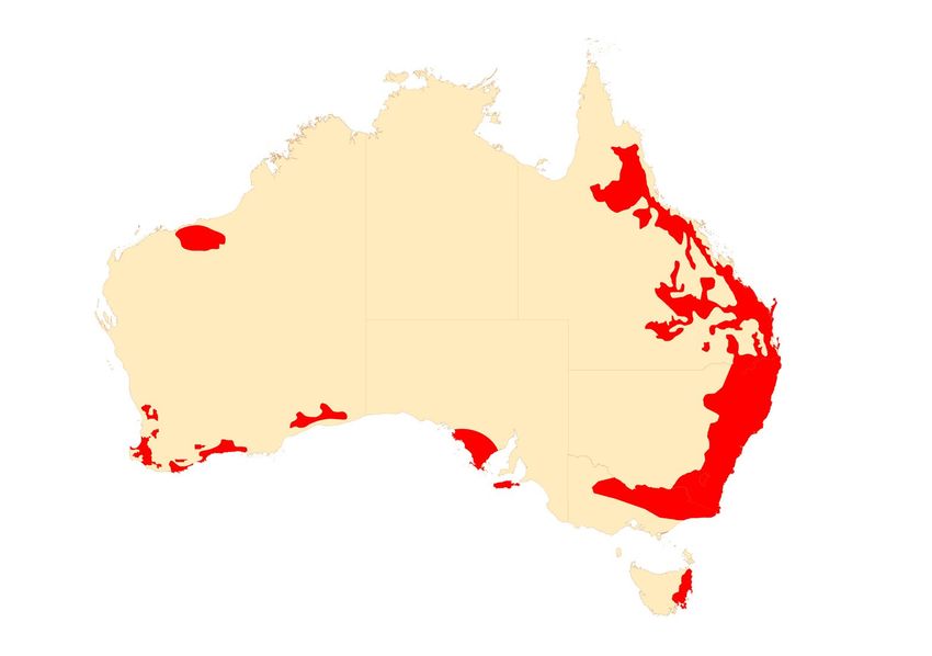
You can also read