Avery Point Lighthouse - Groton, Connecticut - Harley-Davidson
←
→
Page content transcription
If your browser does not render page correctly, please read the page content below
P 9
1 0 R I D E S F O R ’2 0 | R I D E 1
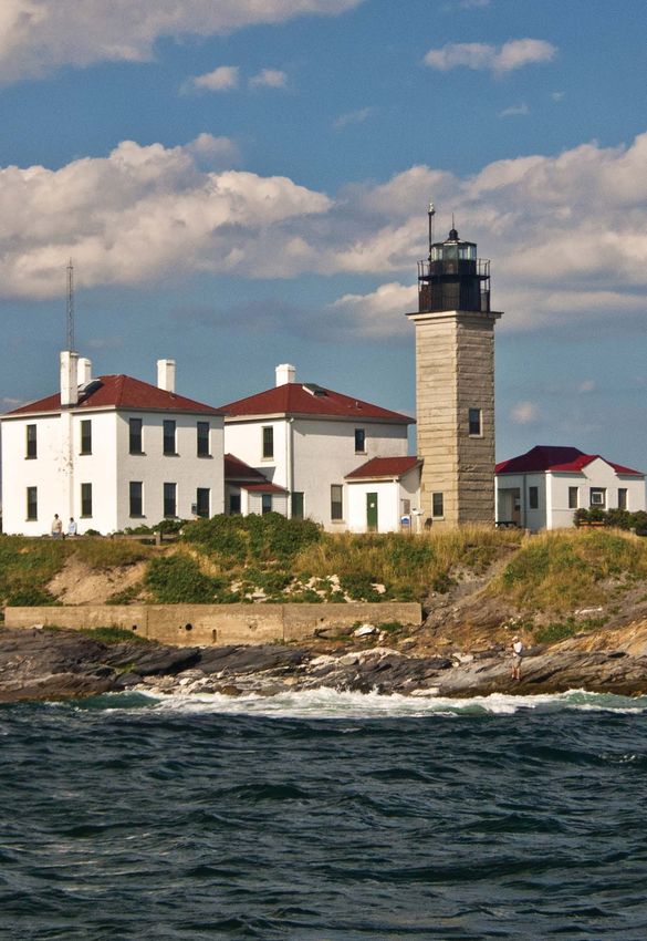
AVERY POINT
2020
IG
L H T HO US
E
Avery Point
Lighthouse
Groton, Connecticut
62 MILES | H-D.COM/RIDEPLANNER
Situated along the rocky shores of Long Island Sound, Avery Point
Lighthouse was constructed in 1943 on the grounds of the former U.S.
Coast Guard Training Station in Avery Point. Previously the estate of
a wealthy industrialist, the site is now the Avery Point Campus of the
University of Connecticut, where the 41-foot octagonal tower sits at the
shoreline on the southern edge of the campus.
Scenic roads abound in this part of the state, and our recommended
route includes Connecticut State Route 169 National Scenic Byway.
Starting at the Massachusetts border and running south through the
state’s Eastern Uplands region, you’ll ride through rolling hills and
historic colonial towns and past miles of stone wall-lined fields; the
CHECK-IN LOCATION:
region is rich in history and natural beauty.
Find visitor parking on the UConn campus, and follow the walkway to the lighthouse.
Your photo should include the lighthouse structure.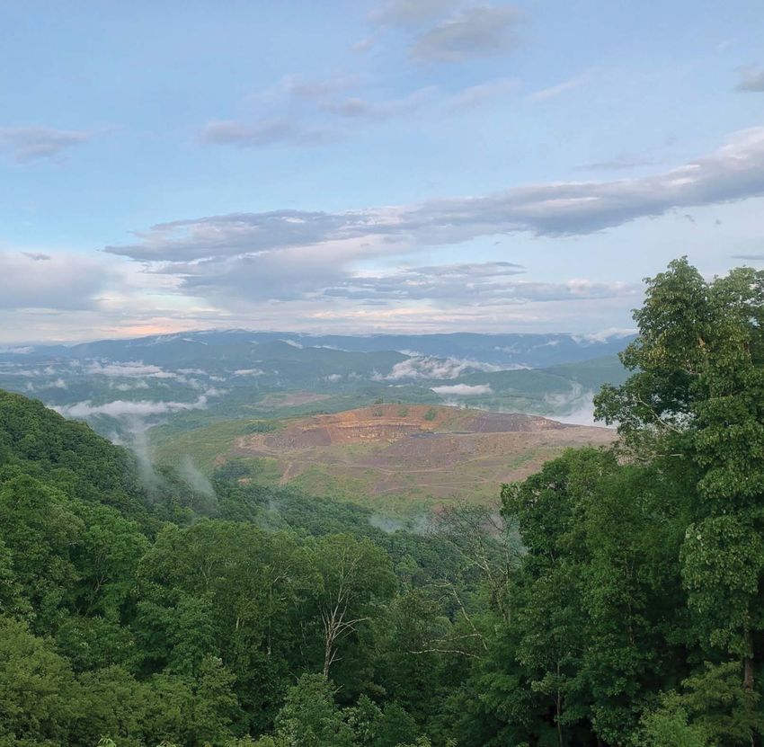
P   11

1 0 R I D E S F O R ’2 0 | R I D E 2
                                                                                                                     CHECK-IN LOCATION:
                                                                                                                     Donner Memorial Bridge (also known as Rainbow Bridge or Donner Summit Bridge):
                                                                                                                     The concrete arch span, constructed during the 1920s, overlooks Donner Lake. Park at
                                                                                                                     the scenic pullout at the east end of the bridge, and include all or part of the bridge in
                                                                                                                     your photo.
                                                                          2020

                                                                 DONNER PASS

                                                   Donner Pass
                                                       9 miles west of
                                                     Truckee, California
                                                        160 MILES | H-D.COM/RIDEPLANNER

                                       A chill wind blew over California’s Sierra Nevada Mountains during the
                                       winter of 1846-1847. Snowdrifts up to 20 feet deep trapped a westward-
                                       bound wagon train led by the Donner brothers. The group was forced to
                                       spend the winter at what is now Donner Lake, near today’s Donner Pass.
                                       Battling starvation, they slaughtered their cattle and oxen to survive, and
                                       when food ran out, they reportedly resorted to cannibalism.

                                       Obviously, Donner Pass can be a pretty inhospitable place in wintertime,
                                       but is quite biker-friendly the rest of the year. Start your journey in the
                                       historic town of Truckee, just northwest of Lake Tahoe. Head west on
                                       Donner Pass Road — also called Old Highway 40 — past Donner Lake
                                       and Donner Pass. From there, travel the Yuba-Donner Scenic Byway, a
                                       175-mile loop through Tahoe National Forest and several historic gold
                                       rush towns in the Sierra Nevada foothills.

                                                                                                                      Photo Credit: (Bottom) California State Parks 2019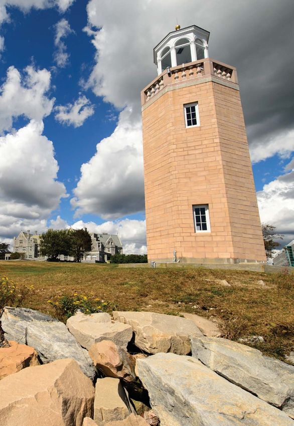
P   13

1 0 R I D E S F O R ’2 0 | R I D E 3

                                                                2020

                                                            BONNEVILLE

                                       Bonneville Salt Flats
                                             Northwest Utah, off I-80
                                             near the Nevada border
                                                        232 MILES | H-D.COM/RIDEPLANNER

                                                                                                                 CHECK-IN LOCATION:
                                       The Bonneville Salt Flats should be familiar to all motorsports
                                                                                                                 At Exit 4 (marked “Bonneville Speedway”), ride north on Leppy Pass Road for about
                                       enthusiasts. Its thick salt crust — the remnants of a huge Pleistocene-
                                                                                                                 1 mile, then turn right onto Bonneville Speedway Access Road and travel 4 miles until
                                       era lake — provides the ideal flat surface for record-breaking speed
                                                                                                                 the pavement ends, where you’ll find the welcome sign.
                                       runs. Since 1914, racers from around the world have come to Bonneville
                                       to satisfy an ever-increasing need for speed.

                                       The Salt Flats are located off Exit 4 on Interstate 80, about 120 miles
                                       west of Salt Lake City. Our recommended route begins in Woodruff in
                                       the northeastern corner of the state on UT-39 along the Ogden River
                                       Scenic Byway. Running along the Ogden River and through narrow Ogden
                                       Canyon, this route takes you through Ogden and Salt Lake City before
                                       continuing west to Bonneville Salt Flats.

                                                                                                                 Photo Credit: Visit Utah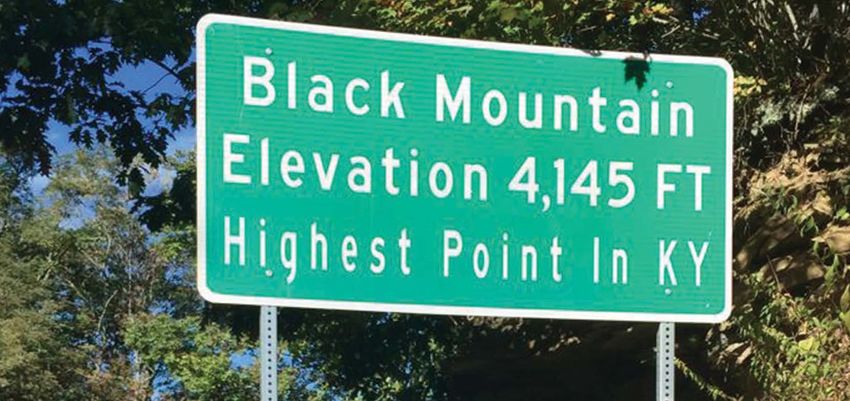
P   15

1 0 R I D E S F O R ’2 0 | R I D E 4                                                                              CHECK-IN LOCATION:
                                                                                                                  The Archway span: Take Exit 275 off Interstate 80, and park in the attraction’s lot.
                                                                                                                  (Do not stop on the interstate highway!) Your photograph should include all or part
                                                                                                                  of the Archway spanning the highway.

                                                                         2020

                                                  The Archway
                                                     Kearney, Nebraska
                                                       172 MILES | H-D.COM/RIDEPLANNER

                                       Westward ho, pioneers! The Archway in Kearney, Nebraska, celebrates
                                       the pioneering spirit of generations of travelers who crossed the state
                                       on their journey west. Dedicated in 2000 as the Great Platte River Road
                                       Archway Monument (and later shortened to simply “The Archway”), the
                                       308-foot structure spans Interstate 80 3 miles east of Kearney. With its
                                       displays and dioramas showcasing westward expansion, the Archway is
                                       the only museum to straddle an interstate highway.

                                       Start your journey to the Archway with a jaunt through the Loup Rivers
                                       Scenic Byway, which traces the paths of the North, Middle and South
                                       Loup rivers through rural central Nebraska.

                                                                                                                   Photo Credit: (Top) Nebraska Tourism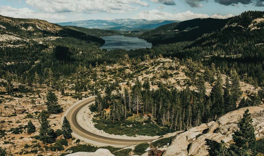
P   17

1 0 R I D E S F O R ’2 0 | R I D E 5
                                                                                                                    CHECK-IN LOCATION:
                                                                                                                    Highway sign on Black Mountain Ridge Road: “Black Mountain, Elevation 4,145 Ft.”

                                                                             O
                                                                          K M UN

                                                                   BLAC

                                                                                    TAI
                                                                                       N
                                                                          2020

                                             Black Mountain
                                              Harlan County, Kentucky
                                                        168 MILES | H-D.COM/RIDEPLANNER

                                       In the heart of the Appalachian coal region, Kentucky’s Black Mountain
                                       sits at the highest point in the state at 4,145 feet. A narrow, paved road
                                       winds close to the summit. Black Mountain Ridge Road is accessible
                                       off State Route 160 between Lynch, Kentucky, and Appalachia, Virginia.
                                       Traveling from Lynch, look for the turnoff on the right just before the
                                       state line.

                                       Our recommended route takes you over the Wilderness Road Heritage
                                       Highway, a national scenic byway running through Daniel Boone National
                                       Forest and leading to Cumberland Gap. At the Gap, be sure to ride
                                       Pinnacle View Road to the scenic overlook, which offers spectacular
                                       views of Kentucky, Virginia and Tennessee.

                                                                                                                     Photo Credit: (Top) Conway Hawn
P   19

1 0 R I D E S F O R ’2 0 | R I D E 6                                                                                CHECK-IN LOCATION:
                                                                                                                    Battleship Memorial Park sign: A military jet sits atop a concrete base marked
                                                                                                                    “Battleship Memorial Park” at the entrance off U.S. 98. You do not need to enter the
                                                                                                                    parking lot unless you intend to visit the battleship; if so, parking and entry fees apply.
                                                                                                                    See USSALABAMA.COM for details.

                                                                 6
                                                                         2020

                                                                 USS ALABAMA
                                                                                  0

                                                    USS Alabama
                                                       Mobile, Alabama
                                                        164 MILES | H-D.COM/RIDEPLANNER

                                       The “Mighty A,” as the USS Alabama is known, performed valiantly in
                                       both the Atlantic and Pacific theaters during World War II. Commissioned
                                       in August 1942, the 45,000-ton battleship earned nine battle stars for
                                       meritorious service in the war. Now preserved for the enjoyment and
                                       appreciation of generations to come, the USS Alabama is the centerpiece
                                       of Mobile’s Battleship Memorial Park.

                                       Our suggested route starts at Battleship Memorial Park and follows the
                                       path of Alabama’s Coastal Connection National Scenic Byway. You’ll pass
                                       historic military forts and Gulf Coast beaches and fishing ports, and take
                                       a ferry across Mobile Bay. (See MOBILEBAYFERRY.COM for schedule
                                       and cost.)

                                                                                                                     Photo Credit: (Middle) USS Alabama Battleship Memorial Park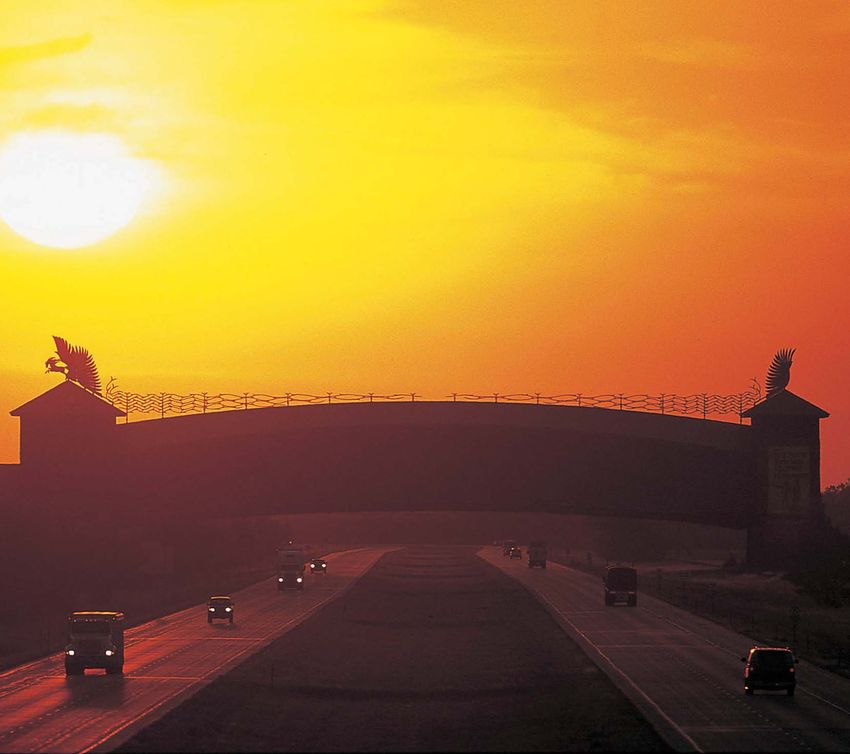
P    21

1 0 R I D E S F O R ’2 0 | R I D E 7
                                                                                                                   CHECK-IN LOCATION:
                                                                                                                   Cape Hatteras Lighthouse: Your photo should include the lighthouse itself.

                                                              CAPE HATTERAS
                                                                              20
                                                                            20

                                              Cape Hatteras
                                               Lighthouse
                                              Buxton, North Carolina
                                                       180 MILES | H-D.COM/RIDEPLANNER

                                       Shining brightly to warn sailors of the treacherous Diamond Shoals
                                       off the North Carolina coastline, the Cape Hatteras Lighthouse was
                                       constructed in 1870 to replace the original 1804 light station, which
                                       was destroyed during the Civil War. Rising 208 feet into the sky, Cape
                                       Hatteras Light is the tallest brick lighthouse in the United States. Its
                                       black and white spiral stripes are a distinctive feature of Cape Hatteras
                                       National Seashore.

                                       Our suggested route includes two scenic highways: Pamlico Scenic
                                       Byway and Outer Banks Scenic Byway. Pamlico runs along Pamlico
                                       River and Sound, and Outer Banks Byway crosses North Carolina’s
                                       barrier islands, offering sun-splashed views of the Atlantic Ocean,
                                       nature and wildlife preserves and small historic towns.

                                                                                                                                                                  Photo Credit: Outer Banks Visitors Bureau
P   23

1 0 R I D E S F O R ’2 0 | R I D E 8

                                                                 20             20

                                                     Beavertail
                                                    Lighthouse
                                           Jamestown, Rhode Island
                                                       35 MILES | H-D.COM/RIDEPLANNER

                                       Beavertail Lighthouse stands proudly on the rocky shores of Beavertail
                                       Point, located at the tip of Jamestown’s Conanicut Island on the
                                       grounds of Beavertail State Park. The 64-foot-tall structure, built
                                       in 1856, is constructed of granite and separates the east and west
                                       passages of Narragansett Bay.

                                       Our route begins at Ocean State H-D® Shop in Exeter and runs through
                                       a very rural and scenic part of the state along Ten Rod Road — where
                                       you’ll find brilliant foliage during fall — before crossing the Jamestown
                                       Bridge over Narragansett Bay to Jamestown and Beavertail.

                                                                                                                   CHECK-IN LOCATION:
                                                                                                                   Beavertail Lighthouse: The lighthouse is located at the end of Beavertail Road in
                                                                                                                   Beavertail State Park. (There is no park entry fee.) Your photo should include the
                                                                                                                   lighthouse building itself.

                                                                                                                    Photo Credit: Jeremy D’Entremont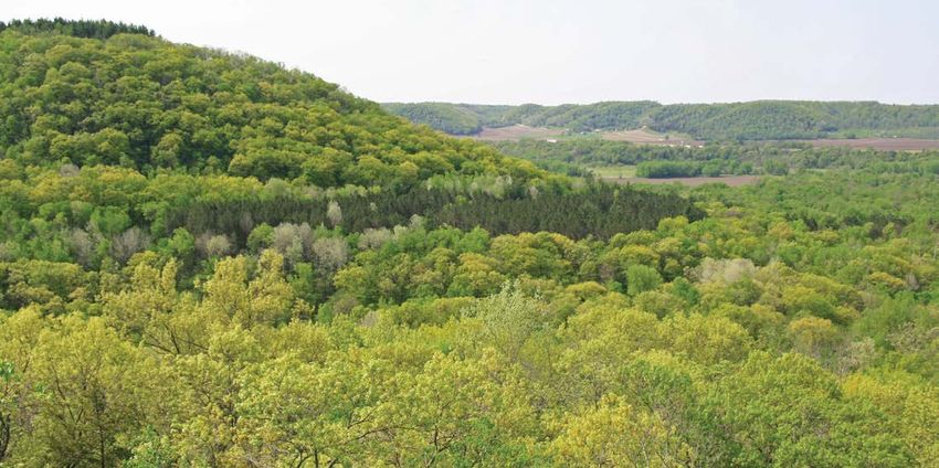
P   25

1 0 R I D E S F O R ’2 0 | R I D E 9                                                                               CHECK-IN LOCATION:
                                                                                                                   Portland Head Lighthouse: Located within Fort Williams Park, the lighthouse has
                                                                                                                   metered parking nearby. Your photo should include the lighthouse building itself.

                                                                        2020

                                                                 PORTLAND HEAD

                                             Portland Head
                                              Lighthouse
                                              Cape Elizabeth, Maine
                                                      281 MILES | H-D.COM/RIDEPLANNER

                                       Portland Head Light is Maine’s oldest lighthouse. Commissioned by
                                       George Washington in 1787 and completed in 1791, the beacon sits
                                       along Casco Bay, Portland Harbor’s main shipping channel. The stone
                                       and brick light station is among the most photographed of Maine’s
                                       roughly 65 lighthouses.

                                       Our recommended route leads north along Maine’s rocky seacoast.
                                       Breathing in the fresh salt air, you’ll ride through historic small towns
                                       and fishing villages, and maybe stop for lunch at one of the state’s
                                       numerous lobster shacks. Along the way, you’ll probably want to take
                                       in Acadia National Park, one of the challenges on H.O.G.’s 50 Rides,
                                       One Nation program.

                                                                                                                    Photo Credit: Jeremy D’Entremont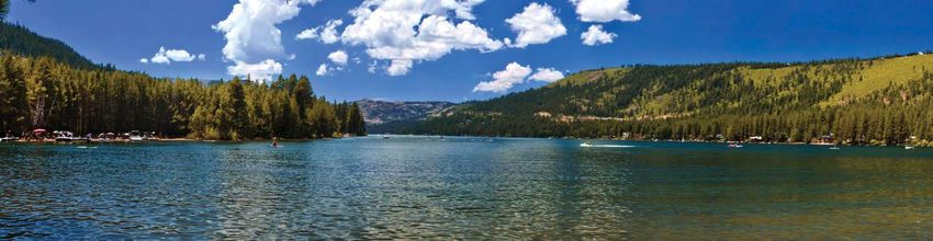
P   27

1 0 R I D E S F O R ’2 0 | R I D E 1 0

                                                                        ROU T E

                                                                     60
                                                                     M I N N E S O TA
                                                                          2020

                                                            Route 60
                                                    Millville, Minnesota
                                                        104 MILES | H-D.COM/RIDEPLANNER

                                         Minnesota’s Historic Bluff Country — named for the scenic bluffs along
                                         the mighty Mississippi River — encompasses the Mississippi River
                                         Valley’s lush southeastern region. Spring Creek Motocross Park, located
                                         off MN-60, lies within that area and is home to the famous Spring Creek
                                         National Motocross race.

                                         Start your ride at Faribault Harley-Davidson® in Faribault, and head
                                         east on MN-60 through Zumbrota. The 35-mile stretch of MN-60 from
                                         Zumbrota to the Wisconsin state line near Wabasha is particularly scenic,
                                         running through portions of the Richard J. Dorer Memorial Hardwood
                                         Forest. The motocross park is located off County Route 11, about halfway
                                         between Wabasha and Zumbrota. For a scenic loop, continue south on 11
                                         through Millville, then north on US-63, returning to MN-60, and continue
                                         east to Wabasha.                                                            CHECK-IN LOCATION:
                                                                                                                     Spring Creek Motocross Park: Your photograph should include the park’s entry sign.

                                                                                                                      Photo Credit: (Top) Minnesota Dept. Of Natural Resources (Middle & Bottom) MX Sports
You can also read