BALESTIER HERITAGE TRAIL - A COMPANION GUIDE - Roots.sg
←
→
Page content transcription
If your browser does not render page correctly, please read the page content below
BALESTIER
HERITAGE TRAIL
A COMPANION GUIDE
DISCOVER OUR
  SHARED HERITAGE
OTHER HERITAGE TRAILS IN THIS SERIES

ANG MO KIO           ORCHARD

BEDOK                QUEENSTOWN

BUKIT TIMAH          SINGAPORE RIVER WALK

JALAN BESAR          TAMPINES

JUBILEE WALK         TIONG BAHRU

JURONG               TOA PAYOH

KAMPONG GLAM         WORLD WAR II

LITTLE INDIA         YISHUN-SEMBAWANG
1

     CONTENTS
Introduction                        2   Healthcare and Hospitals             45
                                         Tan Tock Seng Hospital
Early History                        3   Middleton Hospital (now
Development and agriculture              Communicable Disease Centre)
Joseph Balestier, the first              Former nurses’ quarters (now
American Consul to Singapore             Lee Kong Chian School of Medicine)
                                         Dover Park Hospice
After Balestier                      9   Ren Ci Community Hospital
Balestier Road in the late 1800s         Former School Dental Clinic
Country bungalows                        Handicaps Welfare Association
Homes at Ah Hood Road                    Kwong Wai Shiu Hospital
Tai Gin Road and the Sun Yat             The National Kidney Foundation
Sen Nanyang Memorial Hall
Eurasian enclave and Kampong             Houses of Faith                      56
Chia Heng
                                         Goh Chor Tua Pek Kong Temple
Shophouses and terrace houses
                                         Thong Teck Sian Tong Lian Sin Sia
Former industries
                                         Chan Chor Min Tong and
                                         other former zhaitang
Living in Balestier                 24
                                         Leng Ern Jee Temple
SIT’s first housing estate at
                                         Fu Hup Thong Fook Tak Kong
Lorong Limau
                                         Maha Sasanaramsi Burmese
Whampoe Estate, Rayman
                                         Buddhist Temple
Estate and St Michael’s Estate
                                         Masjid Hajjah Rahimabi
The HDB era
                                         Kebun Limau
Other developments in the
                                         Church of St Alphonsus
1970s and 1980s
                                         (Novena Church)
Schools
                                         Seventh-Day Adventist Church
Law enforcement
                                         Salvation Army Balestier Corps
                                         Faith Assembly of God
Clubs and Leisure                   36
Former shooting clubs                    Food Heritage                        67
Singapore Polo Club                      Balestier Market
Balestier Plain: from landing            Street hawkers and markets
ground to sports field
                                         Whampoa Makan Place
Singapore Indian Association
                                         Traditional kopitiam
and Kamala Club
Ceylon Sports Club
                                         Selected Bibliography                73
Singapore Khalsa Association
Singapore Chinese Recreation Club        Credits                              76
Civil Service Club and
Shitoryu Karate Association              Suggested Short Trail Routes         77
Former Malay Film Productions
studio at Jalan Ampas                    Heritage Trail Map                   81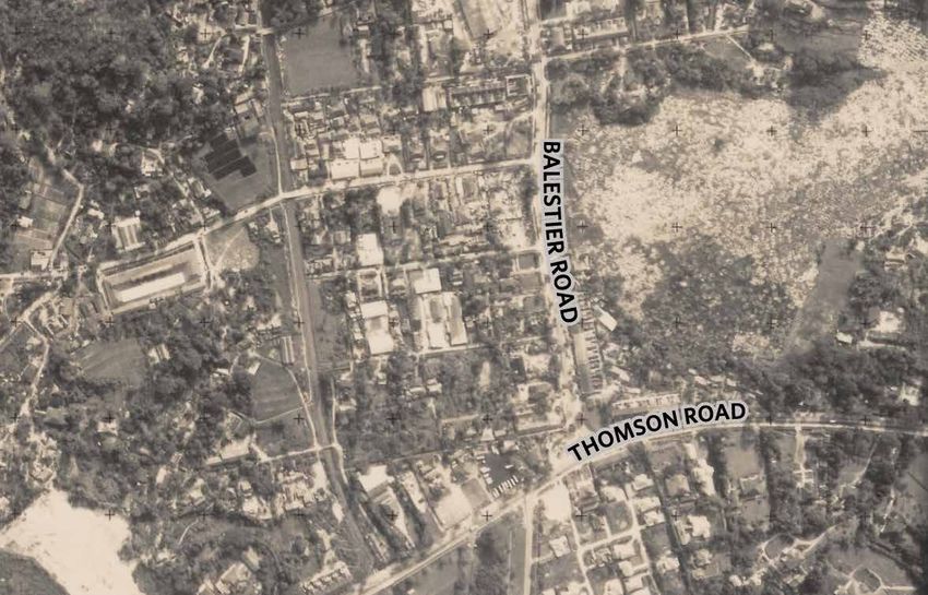
2

INTRODUCTION

The Sim Kwong Ho shophouses along Balestier Road, 2018

T
       he Balestier precinct is named after              institutions such as Goh Chor Tua Pek Kong
       Joseph Balestier, the first American              Temple, Thong Teck Sian Tong Lian Sin Sia
       Consul to Singapore, who owned a                  and Masjid Hajjah Rahimabi Kebun Limau;
sugarcane plantation there. Today, the area is           as well as numerous sports clubs located on
well-known for eateries as well as shops selling         Balestier Plain.
lighting equipment and bathroom goods.
                                                         The Balestier Heritage Trail uncovers the rich
During the 1900s, the Balestier precinct started         history of the area as it transformed from a
to evolve into a residential neighbourhood,              plantation into a precinct filled with shophouses
and it was in Balestier where the Singapore              and buildings with diverse architectural styles.
Improvement Trust (SIT) built its first housing          It also explores the communities, clubs,
estate at Lorong Limau in the 1930s. Most of             schools, healthcare institutions and religious
the SIT houses were later replaced by Housing            landmarks that collectively make up Balestier’s
& Development Board flats by the late 1970s.             unique cultural landscape.

Within the precinct, there are a number of               Follow us on this self-guided trail as we explore
important sites and landmarks such as Tan                Balestier’s rich heritage and gain insights into
Tock Seng Hospital and the former Malay                  this precinct through the memories of those
Film Productions studio; religious and cultural          who have lived, worked and played here!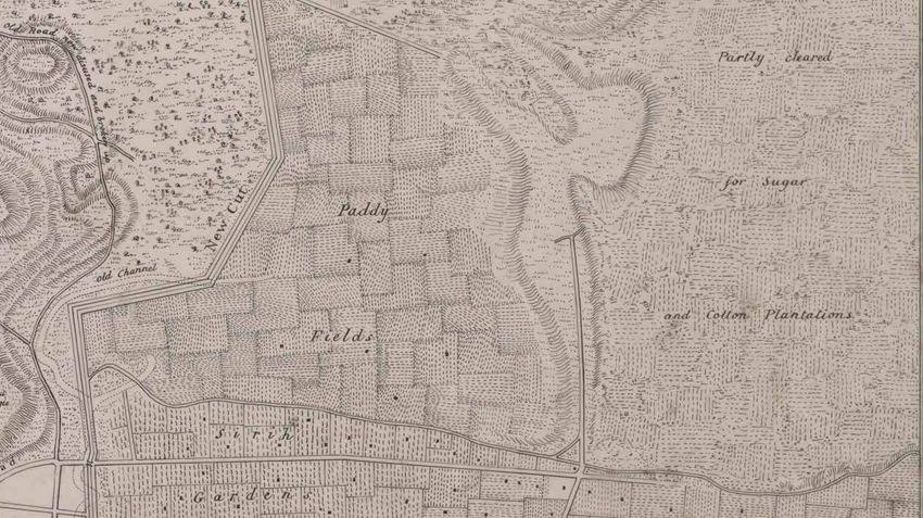
3

EARLY HISTORY
L
     ike much of Singapore in the early 1800s,                       DEVELOPMENT AND AGRICULTURE
     the Balestier precinct was covered in                           In the first decade after Singapore became a
     forest. A small river, initially known as                       British settlement in 1819, the Balestier area
Balestier River and later renamed Sungei                             was still terra incognita (unknown territory)
Whampoa, ran through the area and emptied                            and considered part of the island’s unexplored
into the Kallang River Basin.                                        interior. The British later cleared forests and
                                                                     built roads to provide access to the area. This
Sungei Whampoa was fed by tributaries that
                                                                     painstaking work was carried out by Indian
originated in the vicinity of Bukit Brown, Mount
                                                                     convicts, who were first transported to Singapore
Pleasant and Thomson Road. In the 1860s, the
                                                                     in 1825 to serve as indentured labourers.
area west of Thomson Road was developed
into Thomson Road Reservoir, which was                               By the late 1830s, the lower end of Balestier
renamed MacRitchie Reservoir in 1922                                 Road (still unnamed) had been constructed,
after municipal engineer James MacRitchie.                           as seen from a map drawn by surveyor George
MacRitchie Reservoir remains the primary                             Dromgold Coleman (1795-1844) in 1836. The
source of Sungei Whampoa today.                                      map showed Balestier Road starting from the
                                                                     junction of Serangoon Road and Lavender
North of Sungei Whampoa were hills and                               Street (both then unnamed as well), and ending
swamps that later became known as Toa Payoh                          near the present junction of Moulmein Road.
(“big swamp” in Hokkien, payoh being derived
from paya, Malay for “swamp”). Meanwhile,                            Coleman’s map depicted a largely agricultural
Balestier Road’s southern side was a hilly                           landscape around Balestier Road. Sirih (betel)
area which was later occupied by a Teochew                           and vegetable gardens lined the area around
cemetery and Tan Tock Seng Hospital.                                 the junction of Balestier Road and Serangoon

Balestier Road (unnamed) as indicated in the Map of the Town and Environs of Singapore by George Dromgold Coleman, 1836
Survey Department Collection, courtesy of National Archives of Singapore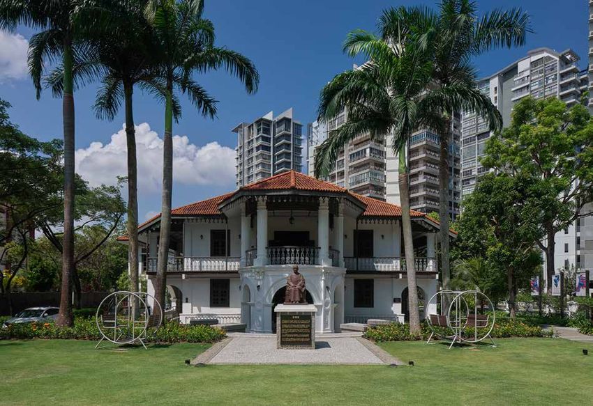
4

Balestier Road and Balestier River (now Sungei Whampoa) as indicated in the Plan
of Singapore Town and its Adjoining Districts by John Turnbull Thomson, 1846
Courtesy of National Archives of Singapore

Road. South of Balestier Road were vast paddy                 During the early 1820s, Balestier was mostly
fields. These gardens and fields were probably                based at St Thomas, a Caribbean island, where
established by early settlers to provide food                 he learned about growing and processing
for the island’s growing population.                          sugarcane. He also served as a Consular
                                                              Commercial Agent on the island of Puerto Rico.
Coleman marked the area north of Balestier                    These stints equipped him with the skills to
Road as being “partly cleared for sugar and                   later work as a planter and Consul in Singapore.
cotton plantations”. This same area was later
depicted as a “sugar plantation” in a map                     From 1824-30, Balestier established a trading
drawn by surveyor John Turnbull Thomson                       business in New York City, but unfortunately
(1821-84) in 1846. The plantation was owned                   this venture failed. Balestier then applied to the
by Joseph Balestier, the first American Consul                US government for an overseas posting, and
to Singapore, and the adjoining road was                      in 1833, Balestier was appointed America’s
named after him.                                              Consul to Riau (now Bintan).

By this time, Balestier Road had been extended                The Balestiers arrived at Riau in May 1834
to the present Kim Keat Road junction, and                    only to find a quiet port with no European
fruit trees lined the road as well as the hilly               or American merchants. This was because
area north of Moulmein Road (then known as                    regional trade had shifted to Singapore by
Cross Garden Road). The entire area was then                  then. The Balestiers promptly relocated to
known as Rochore District after the Rochor                    Singapore where they first resided in Boustead
River which formed its southern boundary.                     Building, a warehouse by the Singapore River.
                                                              Balestier then wrote to the US government to
JOSEPH BALESTIER, THE FIRST AMERICAN
                                                              be redesignated Consul to Singapore instead,
CONSUL TO SINGAPORE
                                                              and this change was formalised in 1837.
Born in 1788, Joseph Balestier lived in Boston, a
city in the state of Massachusetts in the United              Balestier’s consular duties included looking
States of America (USA). He married Maria                     after and helping distressed and shipwrecked
Revere (1785-1847) in 1814 and she bore their                 American sailors or those accused of crimes.
only son Joseph Warren Revere Balestier in 1819.              To supplement his meagre salary as Consul,
5

Balestier also worked as a shipping agent,            the cane fields in the 1840s. These Hokkien
taking a commission for goods he bought or            workers established Goh Chor Tua Pek Kong
sold on behalf of visiting vessels, and supplied      Temple in 1847, which still stands at Balestier
provisions to visiting ships.                         Road today (more details about this temple
                                                      can be found on page 56).
These sources of supplementary income
allowed the Balestiers to relocate to a               Balestier’s efforts bore fruit in 1838 when his
bungalow at Kampong Gelam in October 1834.            sugarcane was finally ready for harvest. After
The Balestiers stayed at Kampong Gelam until          processing the crop, he placed newspaper
1836, when they relocated to a two-storey             advertisements to sell “Singapore (Muscovado
house along North Bridge Road (now the site           and bleached) sugar manufactured according to
of Capitol Theatre).                                  late improvement” and “Singapore molasses”.
                                                      Muscovado is a kind of brown sugar while
Balestier the planter                                 molasses is a thick sugary fluid. Balestier also
Balestier was an active member of the colonial        manufactured rum, an alcoholic beverage made
community, serving on the Grand Jury and in           from sugarcane juice.
the Singapore Chamber of Commerce. He also
provided information about the USA to local           In 1840, Balestier’s family moved to the estate,
newspapers and wrote articles about agriculture.      where they lived in a small wooden plantation
                                                      house with two bedrooms, a parlour and a
Balestier was able to apply his agricultural          dining room. The house was later extended to
knowledge in 1835, when he successfully               accommodate up to 14 servants who cooked
applied for 1,000 acres of land for use as a          and took care of livestock. While Maria took
plantation. The land, which was bordered              care of the household and plantation workers,
by Balestier Road, Serangoon Road, Sungei             Balestier managed the estate with the help of
Whampoa and Kim Keat Road, was originally a           his son and another assistant.
swampy area covered by dense jungle.

To prepare the land for planting, Balestier
employed Indian convicts to drain the swampy
ground and cut the forest. At first, Balestier
tried growing cotton, but the crop succumbed
to pests. Thereafter, he switched to sugarcane,
which he believed would fare better in
Singapore’s climate.
                                                      Muscovado sugar, 2018
To process the sugarcane, Balestier constructed
a wooden mill which was powered by a water
wheel that used water channelled from a small
river next to his estate. This river was originally
known as Balestier River, and renamed Sungei
Whampoa in the early 1900s. The river also
allowed goods to be carried by boats down to
the Kallang Basin and beyond.

Balestier’s workers included Indian labourers
who cut and transported the cane as well as
Chinese workers who worked in the mill and
processing factory. Hokkiens from Fujian
province in China were also employed in               Molasses, 2018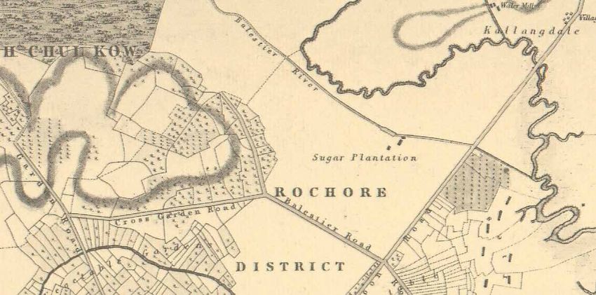
6

WHAT IS SUGARCANE?
Sugarcane (Saccharum officinarum) or tebu in
Malay is a large, tropical member of the grass
family. This crop has been cultivated in Asia
since ancient times for its juice and raw sugar,
which are obtained by crushing sugarcane
stems. The resulting sap is boiled until the
sugar crystallises.                                 A young Malayan tiger, 1900s
                                                    Lim Kheng Chye Collection, courtesy of
                                                    National Archives of Singapore
Sugarcane juice can also be processed into
rum or another liquor called arrack. The            In 1842, Balestier received an old friend,
crushed cane residue (ampas in Malay) has           Captain Charles Wilkes from the United States
many uses: it is processed into paper, used         Exploring Expedition of 1838-42. Wilkes
as fuel for boiling the juice, converted into       described Balestier as being “well known
fertiliser or sold as animal feed.                  among men of science in the United States”
                                                    and added:
Sugarcane was among the many crops
considered for cultivation in Singapore by the      “He was extensively engaged in the cultivation
Agricultural and Horticultural Society. Founded     of sugar, on a plantation of one thousand acres,
in 1836, this society included Balestier and        within two miles of Singapore [town], nearly half
prominent European residents who wanted             of which was under cultivation… He is the first
to pursue the cultivation of economically           person who has attempted the cultivation of sugar
valuable crops such as cotton, sugar, coconut,      in Singapore, and for his success he was awarded
pepper and nutmeg in Singapore.                     the gold medal of the Calcutta Agricultural
                                                    Society [in 1840].”

                                                    Despite these successes, plantation life was not
                                                    without its risks. Tigers became a threat after
                                                    the extensive clearing of forests in Singapore’s
                                                    interior forced them to venture out to rural areas
                                                    and plantations to seek prey. A tiger killed two
                                                    of Balestier’s workers in 1842, and a Chinese
                                                    man was killed in 1843 while constructing a
                                                    tiger pit at the back of Balestier’s plantation.

                                                    Decline of the estate and Balestier’s departure
                                                    Joseph Balestier suffered a great blow in
                                                    1844 when his son died after a violent fever
                                                    and was buried at the European cemetery on
                                                    Government Hill (now Fort Canning Park).
                                                    In 1846, his wife Maria fell seriously ill and
                                                    eventually died on 22 August 1847. She was
                                                    buried next to her son.

A watercolour of the sugarcane plant, early 1800s   Around that time, Balestier began to experience
Courtesy of National Museum of Singapore,           business difficulties. One such difficulty was
National Heritage Board
                                                    the United Kingdom’s heavy import duties
                                                    on sugar and rum from Singapore. Another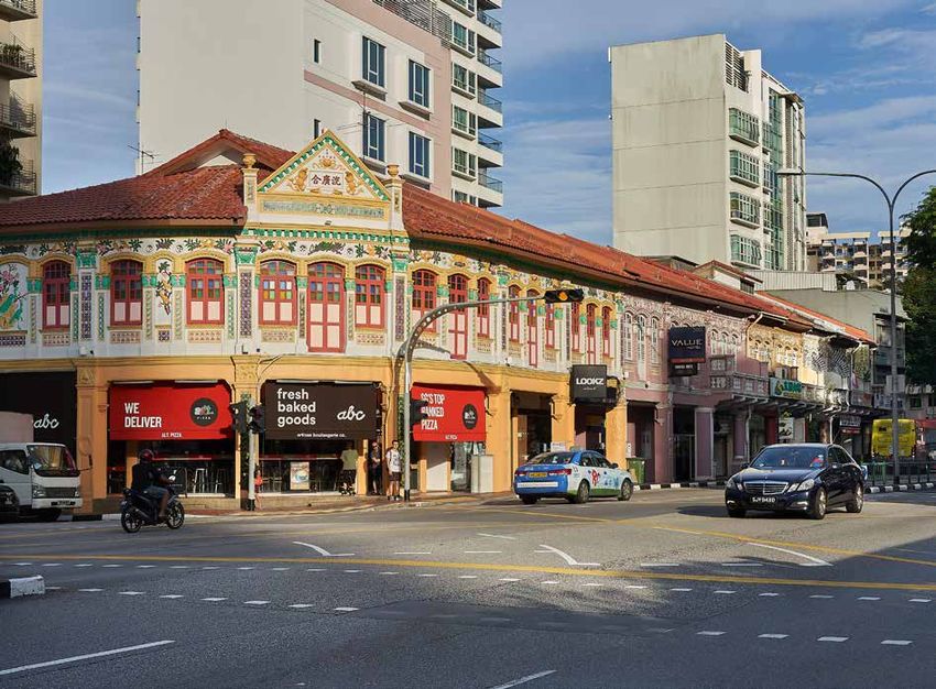
7

Labourers loading harvested sugarcane onto boats, Malaya, early 1900s
Courtesy of National Museum of Singapore, National Heritage Board

Sungei Whampoa, formerly known as Balestier River, 2018

challenge was increased competition from                            After he was released, Balestier made
cheaper sugar from Siam and Indochina. In                           preparations to return to the USA. On 20
some years, unseasonal rain also destroyed                          March 1848, he appointed an American
the crop before harvest time.                                       named Joseph Harvey Weed as acting Consul.
                                                                    Unfortunately, Weed died suddenly in June
By early 1848, Balestier’s health was failing, even                 that year and the post was left vacant.
as he mourned the loss of his family. Floods had
destroyed the previous year’s crop and flooded                      From April 1848, newspaper advertisements
the estate. He suffered a nervous breakdown in                      began to appear for the sale of the “Balestier
March at the prospect of not being able to pay                      Plantation”. Balestier’s former house on the
off his debts. Eventually, Balestier had to give up                 estate was renovated and offered “to let” in
his plantation and all his property. He even had                    1849. There were, however, no buyers, for the
to spend some time in the debtors’ gaol.                            estate or the house.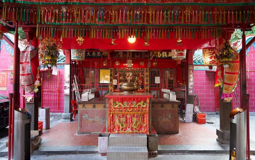
8

Balestier left Singapore on 8 May 1848 and,               Similar attempts by Balestier to obtain
in his farewell tribute, the British governor             permission for Americans to trade in Cochin
William Butterworth (1801-56) wrote that                  China (now Vietnam) and Siam (now
Balestier counted as “one of the oldest and               Thailand) were unsuccessful. Balestier was,
most respected residents” of Singapore. He                however, able to sign a treaty to establish
added that “the name of Balestier, the American
                                                          commercial relations between America and
Consul at Singapore, will have a leading place
                                                          Brunei in 1850.
in the hearts of many and the minds of all, and
that you carry with you the greatest respect
                                                          Balestier returned to America in September
and highest esteem of the community”.
                                                          1851 and officially resigned as American
Balestier after leaving Singapore                         Consul to Singapore on 21 January 1852. Soon
Balestier would later return to Singapore briefly         after, he married Caroline Matilda Fitzhugh
in 1849 on a mission to extend American                   Thompson and settled in Stafford County,
commercial ties in East Asia. He continued to             Virginia. After Caroline died in 1857, Balestier
Hong Kong, Guangdong and Macau, but achieved              moved to York, Pennsylvania, where he died
little there due to the region’s political instability.   on 12 November 1858.

THE REVERE BELL                                           The Revere Bell was in use until 1889. It was
In 1843, Maria Balestier presented a bell                 then kept in storage until 1911 when the bell
cast by the Revere Foundry in Boston, USA,                was installed at St George’s Church at Tanglin
to St Andrew’s Church (now St Andrew’s                    Barracks. Unfortunately, the bell cracked and
Cathedral). Known as the Revere Bell, this is             was again returned to storage until 1937, when
the only bell cast by the Revere Foundry to be            it was given to the Raffles Museum (now
located outside the USA.                                  National Museum of Singapore). Today, the
                                                          bell is displayed in the National Museum’s
The Revere Foundry was established by Paul                permanent gallery.
Revere (1734-1818), Maria’s father, a smith
and supporter of the American Revolution
against the British. Revere was famous for
his daring midnight ride on 18 April 1775
from Boston to Lexington to warn fellow
revolutionaries of approaching British troops.
After the USA gained independence in 1776,
Revere opened his foundry in 1788.

St Andrew’s Church was built in 1835-37 by
George Dromgold Coleman. A tower and spire
were later added by John Turnbull Thomson.
When these additions were completed in 1843,
Maria gifted the Revere Bell to the church on
the condition that it be rung for five minutes
to signal the start of a curfew every evening
at 8pm. The curfew reminded sailors to return
to their ships and residents to be watchful, as           Revere Bell, undated
crimes were common after dark.                            Courtesy of National Museum of Singapore, National Heritage Board
9
AFTER BALESTIER
B
alestier’s former sugarcane estate had no In 1896, Low’s property was advertised for
buyers, most likely because people then sale and described as having a bungalow and
no longer felt that sugar was a lucrative productive fruit trees. Three roads led to Low’s
business in Singapore. Eventually, in the mid- property from Balestier Road, and these roads
1850s, the British government acquired the were later named Ah Hood Road, Tai Gin Road
land, which became known as Balestier Plain. and Boon Teck Road.
A newspaper article in 1874 summed up
Balestier Plain’s early history: Meanwhile, plots in the area between Kim
Keat Road and Jalan Ampas was acquired by
“The Balestier Plain, as it is called, after an different landowners in the 1860s-70s. They
American planter of that name, who lost his own included a Mrs Bowker, G Norris (probably
and other people’s money in trying to manufacture George Norris, a civil servant), William Henry
sugar and rum, ultimately became and now is the Gomes (an Anglican missionary) and Wee
property of Government, with the view to make Boon Whatt, a conveyancer.
the place a sheep farm… That project failed, and
the property became a free shooting ground.” By the early 1880s, small villages had also
been established along Balestier Road. These
BALESTIER ROAD IN THE LATE 1800S were probably the dwellings of Chinese
By 1848, Balestier Road had been extended cultivators who leased part of Balestier Plain
to reach Thomson Road. This development for use as vegetable gardens. One of these
made the area more accessible and attractive villages, which was located between Balestier
to landowners. Around this period, the hilly Road and Sungei Whampoa, later grew into a
area south of Balestier Road was divided into large settlement called Balestier Village.
lots that were acquired by Ung Kim Cheah
By the late 1920s, Balestier Village had
(also spelt Ang Kim Cheai) and Hoo Ah Kay.
become a dense neighbourhood of attap
Little is known about Ung except that he was a
houses. The residents included hawkers and
merchant who contributed to the building of the
vegetable farmers who sold produce such as
Dalhousie Obelisk at Empress Place in 1850.
taro (Colocasia esculenta) that was grown in
Hoo Ah Kay (1816-80), on the other hand, was the many ponds covering the swampy area.
a prominent Cantonese businessman who was Other villagers included artisans, factory
also known as Whampoa after his birthplace, workers and pig breeders.
Huangpu in China’s Guangdong province.
Part of the hilly area between Balestier Road
and Moulmein Road, which he owned in the
1800s, was known as Whampoa’s Hill during
the late 1840s.
From the 1860s, another major landowner in
the Balestier area was Low Jun Tek, a Teochew
opium farmer. The land owned by Low spanned
the area between Thomson Road, Balestier
Road, Sungei Whampoa and the present Boon Then Minister for National Development Tan Kia Gan and
Teck Road. He also had a burial ground in what government staff touring a kampong off Balestier Road, 1959
Ministry of Information and the Arts Collection, courtesy of National
is now Toa Payoh Town Park. Archives of Singapore10
A kampong off Balestier Road, 1959
Ministry of Information and the Arts Collection, courtesy of National Archives of Singapore
The many names of Balestier Road Whampoa, was transported in bullock carts
Although officially named Balestier Road, from the area to other parts of the island for sale.
locals had their own names for the road and
Another old name for the area was Kebun Limau
its surrounding area. For instance, Hokkiens
(Malay for “lime garden”), as many lime trees
referred to Balestier Road as Or Kio (“black
were once cultivated in the area, especially
bridge”), after a bridge that was said to have
around Kim Keat Road and Moulmein Road.
been located near the junction of Balestier
Road and Moulmein Road. Zainul Aljunied (b. 1947), who once lived near
the junction of Ah Hood Road and Balestier
Tan Kee Seng (b. 1927), who stayed at Ah Road, explained the origin of this name:
Hood Road in the 1950s, was familiar with
Balestier Road’s Hokkien name: “I was told that before our family house at 540
Balestier Road was built, the land was a plantation
“Balestier Road was also called Or Kio. You would for limau kasturi or calamansi [a species of lime].”
take bus 19 and get off at the [Thomson Road]
end – that was Or Kio. The whole area was called The junction of Balestier Road and Serangoon
Or Kio. I think it was because there was a black- Road also had different names. It was once
painted bridge there. But the bridge was probably called Rumah Miskin (“House of the Poor” in
demolished long ago.”
Another Hokkien name for the road was Goh
Chor Tua Pek Kong. This referred to a temple
dedicated to the Chinese deity Tua Pek Kong,
which was built at Balestier Road in 1847. The
name “Goh Chor” means Rochore in Hokkien,
referring to the district’s name during this
period. Meanwhile, the Cantonese referred
to Balestier Road as Wu Hap Thong or “taro
pond”, as this crop was widely planted here in
the late 1800s.
In Tamil, Balestier Road was known as
A bus along Balestier Road, 1956
Thanir Kampong or Thannir Kampan (“water Ministry of Information and the Arts Collection,
kampong”) as water, likely drawn from Sungei courtesy of National Archives of Singapore11
Malay), referring to Tan Tock Seng Hospital
(also known as the Chinese Pauper Hospital),
which was based there from 1860-1909.
Rumah Miskin was also the name of a police
station that stood at this junction from the late
1800s until the early 1990s.
Near this junction, there was also a Malay
village with many nangka or jackfruit trees.
This gave rise to the area’s Hokkien name of
Mang Ka Kha or “foot of the jackfruit tree”. Teo
Ah Wah (b. 1940), who grew up near Balestier
Road in the 1950s, shared: Kim Keat Road, which led to Lian Shan
Shuang Lin Monastery in Toa Payoh, c. 1930s
Courtesy of National Museum of Singapore,
“This end of Balestier Road – the Lavender Road National Heritage Board
and Serangoon Road junction – was known as
Mang Ka Kha. Why? Some said jokingly that it worked or had businesses in the town area.
was because there were many mosquitoes which Country bungalows were also built along roads
bit people’s legs. But I don’t think it was this reason. such as Boon Teck Road. This road was named
It should have been because there were many in 1901 after Wee Boon Teck (1850-88), a
nangka trees there then. So the area around these Teochew merchant whose family owned land
trees was called Mang Ka Kha.” in the area.
COUNTRY BUNGALOWS There were also country bungalows along Kim
From the late 1800s, larger houses began to Keat Road, whose residents included Chew Lye
appear along Balestier Road, as the town area Huat, a Straits Chinese merchant, and Lee Hak
had by then become crowded and commanded Heng, a building contractor and fish trader.
high rents. This situation, according to a 1895 The road’s most prominent resident, however,
newspaper report, was “driving Europeans and was Choa Kim Keat (1858-1907), who built a
Eurasians of slender means to the suburbs, country house in the neighbourhood in 1895.
and what was only a collection of attap hovels Both Kim Keat Road, which led to Choa’s house,
on Ballestier [sic] Road, is gradually giving and Kim Keat Lane, a side road, were named
place to decent though inexpensive houses”. after Choa in 1901 and 1902 respectively.
By 1901, much of Balestier Road was lined by Born in Melaka, Choa came to Singapore to work
as a salesman. In 1886, he joined Straits Trading
country bungalows owned by residents who
Company and became a successful sales agent.
He also managed the rice business of Tan Kim
Ching, the eldest son of Tan Tock Seng and also
Choa’s father-in-law.
During his lifetime, Choa was also well-known
as a collector of rare plants and orchids. He
hosted regular parties at his Balestier home,
where visitors could admire his prize-winning
flowers. Choa also took part in flower shows
at the Botanic Gardens, where he displayed
begonias, roses and dahlias. After Choa’s
A bungalow at Akyab Road, 1982 death, his plant collection was auctioned off
From the Lee Kip Lin Collection. All rights reserved.
Lee Kip Lin and National Library Board, Singapore 2009. and most of his land at Balestier Road was12
The home of George Bennett Taye at 2 Kim Keat Road during a flood, 1930s
Courtesy of Gerardine Donough-Tan
either acquired by the government or sold off HOMES AT AH HOOD ROAD
by his descendants just after World War II. Ah Hood Road was originally named Mandarin
Road in 1901, but was renamed a year later
George Bennett Taye (1883-1946), a Straits
after Wee Ah Hood (1828-75), a Teochew
Chinese entrepreneur and insurance agent,
pepper and gambier merchant. Wee’s family
also had a house at Kim Keat Road in the early
1900s. Describing her grandfather’s house, owned a burial ground at Ah Hood Road where
Gerardine Donough-Tan (b. 1955) said: his son Wee Kim Yam, an opium and spirit
farmer, was buried in 1914.
“No. 2 Kim Keat Road was where my grandfather’s
family lived. There was a long driveway, because According to former resident, Koh Swee Gek
the house was far in from the road. Now, Kim (b. 1945), Ah Hood Road once crossed Sungei
Keat Gardens stands there, renumbered 6 Kim Whampoa and led to a hilly and wooded part of
Keat Road – the first block of flats behind the Sim Toa Payoh, before the Pan-Island Expressway
Kwong Ho shophouses.” (PIE) was built in the 1970s. Koh’s granduncle,
Seow Cheng Watt, owned a large family estate
Living near the Tayes was the family of Song off Ah Hood Road until the late 1950s, when
Hoot Kiam (1830-1900), a prominent Straits the land was acquired by the government.
Chinese who was the father of Song Ong Siang Recalling the estate, Koh shared:
(1871-1941), a lawyer and the first Chinese to
be knighted by the British in 1936. Recalling “There were three houses there. One was my
what her mother and aunts had shared about grandmother’s brother’s house, another was our
their neighbours, Donough-Tan said: house, and up the hill was my granduncle’s second
wife’s house. The whole estate belonged to my
“The Songs had a huge house with a compound, grandmother’s brother.”
a lake and a long driveway… My aunts, the girls
of the Taye family, used to play and fight with the Describing her house at 13/2 Ah Hood Road,
neighbours – they took mud from the lake and which often flooded during the rainy season,
threw it at the Songs!” Koh said:13
“It was a very beautiful house in the sense that you 1800s. Their house was built by Syed Abu Bakar
can’t find such houses today. The house was very bin Omar Aljunied. He later passed down the
big with an open patio. Inside was an air well so you property to his only daughter Sharifah Alwiyah
had sunlight coming in… In December, it was always Aljunied, who married her cousin Syed Abdul
flooded. We had to wade through the area. It was Rahman Aljunied, the founder of Madrasah
like a valley and behind us was a hill which had Aljunied at Victoria Lane in 1927.
many fruit trees. Every time the fruit season came,
we would go and pick durians and rambutans.” Zainul Aljunied, who grew up at the Aljunieds’
family home at 540 Balestier Road, described
Koh’s cousin, Dr Ruth Chia (b. 1940), also his grandfather Syed Abdul Rahman as a man
remembered Ah Hood Road and Balestier Road of great stature with a commanding presence:
well. Describing the area in the 1950s, she said:
“He was a very loving person, he loved to carry me
“Sometimes I would take a bus [from school], stop and kiss me. I remember him until I was about 6
at Balestier Road and walk into Ah Hood Road. or 7 years old; after that he passed away. He had
There was a river and a bridge, and we crossed a lot of charisma, but he was always smiling and
that and there was my grandmother’s house.” down-to-earth.”
Chia recalled that Balestier Road then was “one Describing the area around the house, which
of the more built-up areas, busy and bustling,” was called Kebun Limau, Zainul said:
although it was “not posh like Orchard Road”.
Side roads such as Ah Hood Road were still dirt “Our compound went all the way to the Whampoa
tracks and lined by small shops and houses on River. We had all sorts of fruit trees like rambutans,
stilts. She shared: coconuts and mangos, and fantastic orchids. We
would swim in the river, catch fighting fish, play
“We used to buy things from the little shops, like with spiders, and during floods, we cut and tied
rubber bands to play and shoot things. The most banana leaves together into a raft.”
memorable experiences I had was running around
up the hill among the tombstones to play hide and
seek – can you imagine that?”
The Aljunieds at Balestier
Another prominent family who made Balestier
Road their home were the Aljunieds. The
Aljunieds are descendants of Syed Omar bin
Ali Aljunied (1792-1852), an Arab from the
Hadhramaut region in Yemen. Syed Omar
was a merchant and landowner who came to
Singapore from Palembang shortly after the
island became a British port in 1819. He was
a generous philanthropist who contributed
to the building of Singapore’s oldest mosque,
Masjid Omar Kampong Melaka, at Keng
Cheow Street in 1820. He also donated the
land on which St Andrew’s Cathedral was
built, as well as the original site of Tan Tock
Seng Hospital at Pearl’s Hill.
Family portrait of Sharifah Alwiyah Aljunied (seated
The Aljunieds originally resided at High Street, front left) with her five daughters, undated
Reproduced with permission of the family of the
but they moved to Balestier Road in the late late Sharifah Alwiyah Abubakar Aljunied14
When the floods became too severe, however,
such as in 1967, the Aljunieds provided shelter to
REGIONAL ROYALTY AT BALESTIER
nearby residents who took refuge on the upper
level of their house until the waters subsided. During the early 1900s, the Balestier area
was also the home of the Sultan of Sulu,
The Aljunied home was particularly lively during an archipelago between Borneo and the
weddings and festivals, as Zainul recalled: Philippines. Another royal personage who
resided in the area was the Sultan of Siak, a
“Our house was like a community centre. When regency in Riau province, Sumatra, Indonesia.
people in the area were getting married, we would The Sultan of Siak’s house was built in 1902
supply them with periuk besar [big pots] to cook and located at Jalan Rajah, which was likely
their biryani and special serving plates.” named after its royal resident (rajah means
“king” in Malay).
During Ramadan (the Muslim fasting month),
the Aljunieds also hosted prayer sessions led
by a family member and prepared communal
meals so that fellow Muslims living nearby kampong folk protected us. We didn’t have to
could break their daily fast. Sharifah Rukayah worry, they knew that we helped the poor,” he
binte Haroon Aljunied (b. 1937), Syed Abdul said. “They protected us and our house was
Rahman’s granddaughter, recalled: never locked.”
“During Ramadan, people would come to our Sharifah Alwiyah, the matriarch of the
place to break their fast and for tewarih (special house, was affectionately called Mak Tok by
communal prayers performed during Ramadan). her family and friends. Zainul recalled that
There were many Javanese kampongs along Ah Mak Tok was an expert in traditional herbal
Hood Road, Jalan Datoh and Jalan Dusun – also medicine. “At the back of the house was her
many Hailam (Hainanese) at Ah Hood Road workshop or bangsal, where she made her ubat
living along the river. [The Javanese residents] [medicine],” he said. “I used to help her pound
would perform wayang kulit (shadow puppets) the ubat.” Zainul’s niece, Dr Sharifah Mariam
during weddings.” Aljunied (b. 1967), added of Mak Tok:
During the 1950s, Balestier Road was
“People in the neighbourhood would come to
notorious for its gangsters. However, Zainul
her for herbal medicine. Chinese Nonyas (Straits
explained that he was never worried as people
Chinese ladies) would buy from her; she even
who lived in the area regarded the Aljunieds
made pulut (glutinous rice) for her Nonya friends
as benefactors of the community. “The
when they went to pray at Kusu Island.”
Mak Tok was also a traditional midwife who
kept special rooms in the house, called the
bilik beranak, for childbirth. Mariam explained:
“This birthing room had to be pristinely clean. No
kids were allowed inside. She had learnt how to be a
midwife, a mak bidan, and this service was extended
to family and friends in the neighbourhood.”
Mariam was a regular visitor to the Aljunied
family house before it was sold in the early
The Aljunied family house at Balestier, undated 1970s. “I grew up with stories of Kebun Limau,
Reproduced with permission of the family of the
late Sharifah Alwiyah Abubakar Aljunied which was part of my life,” she shared.15
TAI GIN ROAD AND THE SUN YAT in 1902. The villa was called Bin Chan House,
SEN NANYANG MEMORIAL HALL possibly after one of his racehorses. The
12 Tai Gin Road building’s architecture is typical of colonial-era
Tai Gin Road is the site of the Sun Yat Sen villas. It features wide verandahs on both sides
Nanyang Memorial Hall, a National Monument to shield the interior from the sun, while large
and the only surviving pre-war villa in the area. windows provide ample ventilation. Its front
Named in 1901, the road’s name means “big has a porte-cochere (carriage porch), above
man” in Hokkien and referred to the Chinese which is a large balcony supported by stately
Protector, a British official in charge of matters fluted Corinthian columns.
related to the Chinese community.
In 1905, Teo Eng Hock (1871-1958), a Teochew
In the late 1800s, a merchant named Boey businessman, bought the villa as a retirement
Chuan Poh (1873-1926) purchased a plot of home for his mother and renamed it Wan Qing
land along Tai Gin Road, on which he built a villa Yuan (Mandarin for “Serene Sunset Villa”). In
the same year, Teo met Dr Sun Yat Sen (1866-
1925), leader of the Chinese Revolutionary
Alliance or Tong Meng Hui, a society that sought
to overthrow the Qing dynasty and establish a
modern republic in China.
Dr Sun had chosen Singapore as the nerve
centre of his revolutionary movement in
Southeast Asia. Teo became a strong supporter
of Dr Sun and in late 1905, he offered his villa
to Dr Sun as the Singapore headquarters of the
Tong Meng Hui. In 1908, Dr Sun also made the
Sun Yat Sen Villa, 1980s villa the headquarters of the Tong Meng Hui in
National Museum of Singapore Collection,
courtesy of National Heritage Board Southeast Asia.
Dr Sun Yat Sen (pictured in the centre of the first row) with members of the Tong Meng Hui at Wan Qing Yuan, 1905-1906
National Museum of Singapore Collection, courtesy of National Heritage Board16
A bronze statue of Dr Sun Yat Sen within the villa’s compound, 2018
Dr Sun resided at the villa during his visits communication base during the Japanese
to Singapore to gather support and raise Occupation. After the war, the building was
funds for the Chinese Revolution. Three reopened as a museum and library called
uprisings to overthrow the Qing monarchy – the Sun Yat Sen Villa in 1966. The villa was
the Huanggang Uprising and Zhennanguan gazetted a National Monument in 1994 and
Uprising in 1907, and the Hekou Uprising in renamed the Sun Yat Sen Nanyang Memorial
1908 – were planned at the villa. With the Hall in 1996.
support of overseas Chinese communities,
Dr Sun’s revolution succeeded when the Qing Subsequently, the National Heritage Board
government fell on 10 October 1911. He then (NHB) took over the management of the
became the first Provisional President of the building in 2009. It revamped the galleries and
Republic of China. reopened the building in 2011 as a museum
that explores the vital role of Singapore and
In 1910, Teo sold the villa and the building went Southeast Asia in the 1911 Chinese Revolution,
through several owners until it was eventually as well as the impact of the revolution on the
acquired in 1937 by six Chinese community Chinese community in Singapore.
leaders: Lee Kong Chian, Tan Ean Kiam, Chew
Hean Swee, Lee Chin Tian, Lee Choon Seng Today, the building is owned by the Singapore
and Yeo Kiat Tiow. In 1938, these men donated Chinese Chamber of Commerce and Industry and
the villa to the Singapore Chinese Chamber managed as a heritage institution under NHB.
of Commerce, which wanted to convert the
EURASIAN ENCLAVE AND
building into a memorial hall for Dr Sun.
KAMPONG CHIA HENG
However, these plans were interrupted by By the early 1900s, a corner of Balestier Road
World War II and the villa became a military had evolved into a small Eurasian enclave. The17
Eurasians are a community of mixed European it lacked public services and suffered from
and Asian heritage, who maintain their distinct clogged drains and mosquito breeding.
identity, culture and culinary practices.
During this period, Kampong Chia Heng had
Bobby Longpoetih (b. 1933), who stayed at about 1,000 residents and they included
Irrawaddy Road from the 1930s until the late Chinese, Malays and Muslim Indians. Donough-
1990s, shared that many Eurasian families Tan recalled that in the 1960s, Kampong
lived near him, as well as along Shan Road Chia Heng “had a roadside market where the
and Martaban Road. “There was a big plot of hawkers sold fruits, vegetables and food almost
terrace houses on Irrawaddy Road and many up to the Thomson Road junction”. She added:
Eurasian families lived in them,” recounted
Longpoetih. “Others lived in shophouses on “There was also a woman selling chai tau kway
the main Balestier Road.” [fried carrot cake]. Those days, there was no
white version. It was all black with sweet sauce,
The Eurasian families who resided in this area and was one of the best I ever had. There was also
had surnames such as Scully, Donough, Aeria, a standpipe not far in from the main Thomson
Alves, Bennett, Fernandez, Valberg, De Souza, Road. It was a communal gathering point amid
Milne, Palmer, Klem, Jansen, Bligh, Ferreira, the bustle of the open-air market.”
Bull and Galistan. Among these residents
Dorothy Seet (b. 1945), who lived at Moulmein
was Cuthbert Oswald Donough (1920-2010),
Road in the early 1950s, shared of Kampong
an employee of Cable & Wireless (a British
Chia Heng:
telecommunications company) and father of
Gerardine Donough-Tan, who recalled: “The whole kampong was our playground, our
friends were all around there. My grandmother
“My father’s family lived at 15 Irrawaddy Road
used to cross a path through the graveyards to
in the 1930s-40s. From late 1962 until 1981,
visit her friend at Kampong Chia Heng to play
our family lived at Moulmein Road. After dad
cherki [a card game]… There were cows there
retired in 1975, he did community work, and more
grazing among the grass. I was so scared; she’s a
so when we shifted to the new HDB estate at
Nonya lady with a scarf. I would tell her, ‘Mama,
Jalan Dusun in 1981. He later became patron of
please take away the scarf’ because I was under
Moulmein Constituency Sports Club and Citizens
the impression that the cows will attack when
Consultative Committee. He would walk the
they see red.”
ground and talked about the district. That’s why
I know the area so well.” Foo Cheow Ming (b. 1964), who lived nearby
in the 1970s, shared this memory of Kampong
One of the neighbourhoods that Donough
Chia Heng:
visited as part of his community work was
Kampong Chia Heng, a small village located “In the early 70s I lived in Jalan Novena Selatan
behind the present Novena Church. Kampong which overlooked Kampong Chia Heng from the
Chia Heng was officially named in 1929 after hilltop next to Novena Church. Looking down
Leow Chia Heng (1870-1931), a Teochew cloth from my bedroom window was this huge, lush
merchant, banker, rubber planter and President green land with a few zinc roof and attap houses
of the Chinese Chamber of Commerce. to my right. It was very, very peaceful, and in the
late evenings and morning the entire area would
In the 1930s, Kampong Chia Heng had a resound with insects and birds chirping.
badminton court as well as an active football
club called the Chia Heng Youngsters. However, “There was a little stream where people would go
living conditions deteriorated after World War to wash clothes and bathe. On top of the opposite
II, and by the 1950s, residents nicknamed their hill would be the hostel blocks for the Tan Tock
village the “Kampong of Forgotten Souls” as Seng Hospital staff – I can still remember seeing18
the big letter ‘G’ on the side of the block and the covered passage on each side of the street”.
kids playing about. Lovely memories, like out of a This passage is popularly known as the five-
misty dream.” foot way (although in practice, most five-foot
ways are wider than five feet).
The land on which Kampong Chia Heng stood
was acquired by the government in 1981 Many traditional shophouses still line Balestier
and the area was later redeveloped into the Road. Perhaps the most exquisite examples of
Novena MRT station. this architectural form in the precinct are the Sim
Kwong Ho shophouses. Located at the junction
SHOPHOUSES AND TERRACE HOUSES
of Balestier Road and Kim Keat Road, these
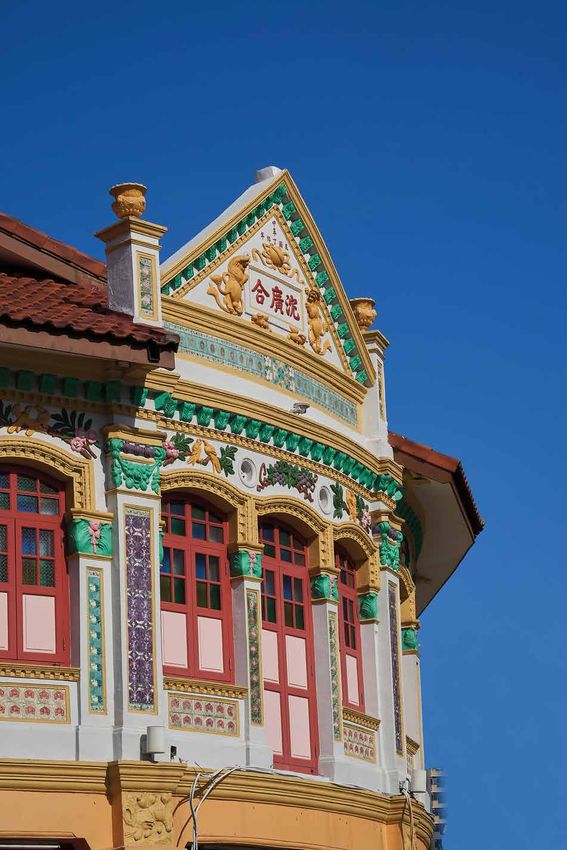
Sim Kwong Ho shophouses: 292-312 Balestier Road
Kwan Yow Luen shophouses: 412-418 Balestier Road
shophouses became known as the Sim Kwong
Art Deco apartment blocks: 230 & 246 Balestier Road Ho shophouses after the Chinese characters
Pre-war terrace houses: Pegu Road and Martaban Road on their corner facade. They were built in 1926
by Sim Cheng Neo, a lady who also owned
Shophouses started to appear along Balestier
Road in the early 1900s to serve the area’s
growing number of residents. They were probably
built by enterprising merchants who sold
provisions and other goods to residents, while
residing in quarters upstairs with their families.
The shophouse is an architectural form that
once dominated Singapore’s urban landscape.
Its origins lie in a Town Planning Committee
headed by Sir Stamford Raffles in 1822 which
stipulated that houses in the town must have Shophouses along Balestier Road at the Kim Keat
Road junction, 1982
a uniform facade and “a verandah of a certain From the Lee Kip Lin Collection. All rights reserved.
depth, open at all times as a continued and Lee Kip Lin and National Library Board, Singapore 2009.
Shophouses along Balestier Road at the Pegu Road junction, 1982
From the Lee Kip Lin Collection. All rights reserved. Lee Kip Lin and National Library Board, Singapore 2009.19 properties at Sophia Road and Roberts Lane, and had a family home at 503 Balestier Road. The Sim Kwong Ho shophouses were designed by the architectural firm of Westerhout and Oman in a richly ornamented style known as Chinese Baroque or Singapore Eclectic. Popular in the 1920s, this style combined European architectural elements with local motifs. For instance, the exterior walls are adorned with plaster stucco work of animals such as bats The corner facade of the Sim Kwong Ho shophouses, 2018 (a symbol of fortune and happiness) and peacocks while elaborate floral wreaths and festoons (garlands) are placed above French- style windows. Sim was also the developer of another row of shophouses at the junction of Jalan Kemaman. Built in 1928, this row was designed by Kwan Yow Luen (1893-1977), a self-taught local architect who designed many traditional shophouses. The Kwan Yow Luen shophouses feature extravagantly detailed plaster stucco Close-up of the peacock motif on the Sim Kwong Ho figures. These include creatures such as shophouses, 2018 dragons and phoenixes as well as auspicious animals such as bats. The main pediment (roof frontispiece) features two lions flanked by buffalo figurines, while the ground floor columns of the corner unit depict Sikh jagas (Malay for “guards” or “watchmen”) who serve as symbolic guardians, as Sikhs were valued as policemen and guards during colonial times. Ian Tan (b. 1976) stayed at a shophouse at 233A Balestier (now Rocca Balestier) until 2000 when a fire destroyed the building. He shared: “I cannot forget what it meant to grow up in a Kwan Yow Luen shophouses, 2018 Balestier Road shophouse during the late 70s and 80s… 233A Balestier was a most remarkable building. By the 1960s, it was inhabited by a huge number of people. Most of the roof was covered with zinc sheets which meant unbearably hot interiors on warm days or a biting chill during the rainy season.” Tan also recalled an open-air courtyard between the living area and kitchen: “This was where we hung our clothes and learnt how to use a tek-goh [bamboo pole] most Close-up of motifs on the Kwan Yow Luen shophouses, 2018
20

Art Deco apartment blocks at 230 and 246 Balestier Road, 2018

Pre-war terrace houses at Martaban Road, 1988
21

expertly, played with all manner of toys, washed        old houses? My grandmother’s friends lived in
our clothes in a huge stone sink and looked up at       Martaban Road and she would visit them. They
the stars in the most quiet of nights.”                 actually ran a bottle shop along Balestier Road,
                                                        it’s closed already.”
The shophouse design, with shops downstairs
and living quarters upstairs, also influenced           FORMER INDUSTRIES
apartment blocks built along Balestier Road             From the late 1800s, a number of industries
after World War II. These post-war buildings,           started to emerge in the area. One of the
which had individual apartments on each floor,          first was a government brick field established
had much simpler designs compared to pre-               along Serangoon Road in 1858. The brick field
war shophouses.                                         used sand from Balestier Plain (currently the
                                                        Balestier Plain sports fields), which was then
Two apartment blocks, built in the 1950s
                                                        known as the Crown sand pits.
across the road from Goh Chor Tua Pek Kong
Temple, stand out for their Art Deco corner             In the late 1800s, there was also a private brick
facades. Art Deco is an architectural style             kiln along Kim Keat Road called Singapore Brick
that became popular in the mid-1900s and                Works. It was owned by Fraser & Cumming, a
favoured streamlined profiles and simplified            company formed in 1875 by John Fraser and
geometric patterns. Both blocks have corner             James Cumming. The kiln was located close
facades with bold vertical fins that project            to Sungei Whampoa, as the river was both a
above the roof level, conveying a sense of              source of water as well as a dumping ground
height and stature.                                     for the disposal of industrial waste.

Another variation of the shophouse design is            From the 1900s, other industries began to
the terrace house, in which the ground floor            appear in the area. These included tanneries,
also serves as a residential space. Such houses         which processed raw animal hide into
can be found at Pegu Road and Martaban Road.            leather. They were located on the south side
Built between the 1920s and 1940s, these                of Balestier Road, and concentrated along
dwellings recall the elegant terrace houses that        Mandalay Road. There were also oil mills and
line Emerald Hill off Orchard Road. Like some           soap factories near Tai Gin Road and Boon
of Emerald Hill’s houses, the front doors of            Teck Road in the mid-1900s.
these houses are separated from the street by
small forecourts, which provide residents with          Sawmills, rubber factories and dye-houses
privacy from passers-by.                                There were sawmills and timber yards at
                                                        Jalan Datoh, Jalan Dusun and Ah Hood Road.
The terrace house at 13 Martaban Road once              These facilities received logs from boats that
housed orderlies (male nurses) who worked at            travelled up Sungei Whampoa all the way from
Tan Tock Seng Hospital. It was later converted          Beach Road. Rahmat bin Sulaiman (b. 1944), a
into a private home and won an Architectural            long-time resident of the area, recalled these
Heritage Award from the Urban Redevelopment             timber yards:
Authority in 2007 for the quality of its restoration.
                                                        “There were many timber yards here around the
Leonard Loo (b. 1959), who stayed at Moulmein           river. We kampong folk would sometimes go
Road in the late 1970s, remembers the Martaban          to them and they would pass us small pieces of
Road houses well:                                       timber which we brought back for our own use.
                                                        These factories were gone some 40 years ago.”
“Until today it’s a very nice walk to Tan Tock
Seng Hospital through Martaban Road. You                Rubber factories also began to appear in the
can see the big old trees and it’s very quiet, very     early 1900s due to the booming demand for
peaceful. And down Martaban Road, you see the           rubber. In 1928, there were rubber factories at
22
A former timber yard in Balestier, 1984
Courtesy of the Urban Redevelopment Authority
Jalan Rajah and Ah Hood Road that employed days, you could get it very fast; today send it,
Hainanese coolies as well as a factory called tomorrow can get.”
Eko Rubber Factory along Balestier Road.
Rattan factories
Another prominent industry that took root in Around the same time, another industry that
Balestier in the early 1900s was textile dyeing. emerged in Balestier was rattan processing.
There were at least three large dye-houses Rattan, also known as cane or rotan, is made
located near Sungei Whampoa during the from a forest palm (Calamus spp.) and widely
1930s. Chua Lai Teck (b. 1957), who stayed at used to make furniture and household items.
Ah Hood Road in the 1960s, recalled that there In the 1930s and 40s, rattan factories were
was a dye-house near the Sun Yat Sen Nanyang located mainly near Sungei Whampoa along
Memorial Hall: Jalan Dusun, Jalan Rajah and Boon Teck Road.
Those at Boon Teck Road were in operation
“At Tai Gin Road, there was one company which until 1978 when they were destroyed by a fire.
dyed clothes. They dyed it all black. For the
Chinese, when someone passed away, they had During the 1950s and 60s, Tan Han Boon (b.
to wear black clothing, so they took whatever 1949) stayed at a house at 582 Balestier Road
clothing they had and dyed it black.” which doubled as a rattan factory. Recalling
the house, he shared:
Chua explained that the workers would pour
dye into a large pail, heat it and throw clothes “It was a compound house, with probably 7-8
into the pail: families – each family rented one room. There were 4
or 5 rattan factories nearby. Ah Hood Road had one,
“You could recognise those working there by their Kim Keat Road had one and also at Jalan Rajah.”
hands – all black. They had no precautions, not
like these days when you’d wear gloves. After Tan explained that the owner of the house used
dyeing, the clothes were hung out to dry. Those the compound for processing rattan. He said:23
Lam Soon is another food-related enterprise
that was formerly located at Balestier. The
firm’s original factory was based at 519
Balestier Road in the 1930s-40s. The factory
doubled up as the family home of the firm’s
founder Ng Keng Soon, who set up Lam Soon
Cannery in 1929. It produced soya sauce,
canned food, cooking oil and soap. The factory
relocated to Jurong in the 1950s.
During the 1930-50s, there were also ponds
near Sungei Whampoa, where fish were
reared for sale. These ponds, collectively
known as Lee Hak Heng Kolam, were located
near the current Block 103 Jalan Rajah. Chua
Lai Teck shared:
Workers arranging rattan at a factory, 1948
Ministry of Information and the Arts Collection,
courtesy of National Archives of Singapore
“There were three big fishing ponds. They reared
fish and stretched up to Kim Keat Road, and were
owned by this person called Lee Hak Heng. He
“They imported cane from Indonesia, then they was a fish trader.”
soak it in a pond overnight to soften it. Then they
use sand and some kind of straw to rub away all Other industries
the thorns and smoothen it. After that, they put At McNair Road, there was a factory called the
it inside a chamber and bleach it with sulphur Elkayes Match Factory, which was established
dioxide. I could smell it every day, the sulphur in 1922 by Lee Kim Soo (1887-1933). The
dioxide. At that time, I didn’t know whether it was factory was named after the way Lee’s initials,
harmful or not.” LKS, were pronounced. It employed about 200
workers and produced matches under the
The rotan was then sold to furniture makers, Crocodile brand.
and quality rattan was used to make wicker
In the 1930s, the factory switched to
baskets. As for poorer quality cane, Tan added:
manufacturing nails after Lee relocated his
“The rejects, they would sell to your mother to
match manufacturing business to Johor.
whack you,” referring to the old practice of
The factory, which later began manufacturing
using rotan to cane children who misbehaved.
cement, was active until the early 1970s, when
Food-related industries it closed following complaints about pollution
by nearby residents.
Siong Hoe Biscuit Factory was established
in 1952 and located at Ah Hood Road. This Apart from private industry, Balestier was
factory manufactured biscuits until the 1990s, also the site of a vital public infrastructure in
after which the site was redeveloped for the mid-1900s. In 1936, a wireless receiving
private housing. Tan remembered going to the station was built between Sungei Whampoa
factory to buy rejected products: and St Michael’s Road. This facility allowed
staff at Kallang Airport, which opened in
“The factory was just across the canal [Sungei 1937, to communicate with aircraft arriving or
Whampoa]. We’d buy broken biscuits from there. departing Singapore. The station operated until
We didn’t buy the good ones. We bought the 1955 when a new receiving station opened at
broken pieces – still can eat!” Yio Chu Kang to serve Paya Lebar Airport.24
LIVING IN BALESTIER
SIT’S FIRST HOUSING ESTATE be met by private developers, and as a result,
AT LORONG LIMAU SIT had to assume the broader role of a builder
I
n 1932, the Balestier area became the site of affordable homes.
of the first public housing estate built by
The densely populated Balestier area was
the Singapore Improvement Trust (SIT),
earmarked by SIT for a major development.
which developed low-rise units around Lorong
Limau, a side lane off Kim Keat Road. In 1930, Balestier Village, which was regarded
as insanitary due to overcrowding and the
SIT had its origins within the Singapore presence of ponds that promoted mosquito
municipal government, which set up an breeding, was acquired and redeveloped as
improvement trust in 1920 for tasks such part of this improvement scheme.
as the creation of backlanes. SIT became
an independent body when the Singapore To rehouse the former village’s inhabitants,
Improvement Ordinance was enacted on 1 SIT built single-storey Artisans’ Quarters.
July 1927 with the mission “to provide for The term “artisan” referred to skilled or semi-
the Improvement of the Town and Island of skilled workers such as tin-smiths, silver-
Singapore”. This mission involved planning smiths, basket-makers and night soil collectors
new roads and open spaces, condemning who earned $30-$35 a month.
insanitary buildings that were found to be “unfit
for human habitation” and redistributing land. Available for a monthly rent of $7, these
quarters consisted of a living room with a bed
Initially, SIT was authorised to build homes recess, a kitchen, a bathroom and toilet. SIT
only for people who had been made homeless also created open spaces around the quarters
by the clearing of insanitary buildings and where children could safely play away from
slums. This changed later, when Singapore traffic. By 1940, SIT had completed 558
faced a severe housing shortage that could not Artisans’ Quarters in the Lorong Limau Estate.
A map showing the SIT Lorong Limau Estate, 1938
Survey Department Collection, courtesy of National Archives of SingaporeYou can also read