Rideau Canal 2019 Guide - Watson's to the www.rideau-info.com - Friends of the Rideau
←
→
Page content transcription
If your browser does not render page correctly, please read the page content below
Watson’s
               2019 Guide
                            to the

Rideau Canal
                                  by

                       Ken W. Watson

 A print compilation of several sections of the Rideau Waterway website:

     www.rideau-info.com

                    Revision date: January 17, 2019
Watson’s 2019 Guide to the Rideau Canal                                                                                                                    Table of Contents

                                                                 Table of Contents

Table of Contents ..................................................................................................................... 1
About this Guide ...................................................................................................................... 2
  What’s in the Guide ................................................................................................................................................... 2
  What’s not in the Guide ............................................................................................................................................. 2
About the Rideau Canal ........................................................................................................... 3
Acknowledgements.................................................................................................................. 3
Location Map ............................................................................................................................ 4
Your Rideau Journey – By Water ............................................................................................ 5
Your Rideau Journey – By Road ............................................................................................. 6
Your Rideau Journey – By Foot, Bicycle, Skate, Ski, Horse, or ............................................ 7
Frequently Asked Questions ................................................................................................... 8
Fees and Schedules ............................................................................................................... 12
  2019 Hours of Operation ......................................................................................................................................... 12
  The Caveats ............................................................................................................................................................. 12
  Bridge Schedules ..................................................................................................................................................... 12
  Maximum Overnight Mooring Period ..................................................................................................................... 13
  2019 Lockage, Mooring and Camping Fees (HST included) .................................................................................. 13
  Boat Launching and Parking* ................................................................................................................................. 14
Locking Through .................................................................................................................... 15
Rideau Canal Statistics .......................................................................................................... 16
A Boater’s Travel Guide to the Rideau Canal ....................................................................... 20
Rideau Communities (with road travel guide) ...................................................................... 37
Marinas & Wharves ................................................................................................................ 54
Boat Launches on the Rideau Canal..................................................................................... 56
A Short History of the Rideau Canal ..................................................................................... 60
Ecology of the Rideau Corridor............................................................................................. 70
  Parks and Conservation Areas ................................................................................................................................. 70
Geological History of the Rideau Canal ................................................................................ 72
Information Contact List ........................................................................................................ 76

Ken W. Watson ( www.rideau-info.com )                                    version: January 17, 2019                                                                         Page 1
Watson’s 2019 Guide to the Rideau Canal                                                                      About the Guide

                                              About this Guide
This guide is a compilation of some of the information available on the website: www.rideau-info.com. This is a non-
commercial website, which first went on-line in 1996 and is maintained on a hobby basis by Ken Watson. Ken has also
authored five books about the Rideau Canal, “A History of the Rideau Lockstations,” first published in 2000; “Engineered
Landscapes – The Rideau Canal’s Transformation of a Wilderness Waterway,” first published in 2006, “The Rideau Route
– Exploring the Pre-Canal Waterway,” first published in 2007, “Tales of the Rideau”, first published in 2010 and Watson's
Paddling Guide to the Rideau Canal, first published in 2012.

It has been noted that many people print sections of the website to take with them on their visits to the Rideau. This guide
has been prepared to simplify that process, to provide a print and/or portable PDF version of various sections of the website
that the visitor might find useful on their Rideau trip. Although I have tried to make the information accurate and up to date,
I cannot warrant all the information contained in this document. You can help by informing me of any corrections or
updates. I can be contacted at: rideauken@gmail.com

                                               What’s in the Guide
The Table of Contents pretty well says it all. The main idea was to include much of the information that the visitor would
like to have with them on their Rideau trip. For those with more specific interests (i.e. fishing, canoeing, etc.), sections
containing that type of information can be printed directly from the website.

                                           What’s not in the Guide
Keeping in mind that www.rideau-info.com is a very large website, a number of things that are on the website but were felt
to be special interest, or too large to include, were left out of this guide. For example:
     • Accommodation listings: detailed listings of all the inns, hotels, B&Bs, campgrounds, lodges, etc. in the Rideau
       Corridor. Some are listed on the website, others are available on tourism association websites.
     • Coming Events: these are posted to the website as they become available.
     • Fishing Information: detailed information about the season and fish species (it’s all on the website).
     • Maps: only the general map of the Rideau and community locations has been included – other maps on the website
       include road maps, community maps and even a geology map of part of the Rideau. It is assumed that a visitor to the
       Rideau will have their own maps (i.e. a navigation chart, road map, etc.).
     • Boat Rental information: the website contains links to the various firm’s own websites for detailed information
     • Driving Tour Information: several driving tours, catering to specific interests, are available on the website
     • Detailed History: although a general history of the building of the Rideau Canal and histories of each community
       has been included, the website includes much more detailed information on the history of each lock as well as
       general history of the region.
     • Canoeing/Kayak Information: the website contains some detailed information for the paddler, including trip
       suggestions. You can also view/download my free “Watson’s Paddling Guide to the Rideau Canal” with all the
       information and maps that you will need to paddle the Rideau Canal.
     • Photos: in order to keep the file size down (it is already too big without photos) the information has not been photo
       enhanced. There are over 500 large size photos in the website’s photo gallery as well as dozens of other photos
       scattered throughout the website. Also on the website are photo tour videos of each Rideau Canal lockstation.
     • Whole Bunch of Other Stuff: the website also contains a large assortment of “other” items; quizzes and puzzles;
       behind the scenes info about the canal; weather forecast links; articles about Rideau trips; links to dozens of Rideau
       related websites; polls and surveys; boating rules; lake association information; local cottaging information; and
       more ….
           If there is something specific on the website that you think should be in this guide, please let me know.

Ken W. Watson ( www.rideau-info.com )              version: January 17, 2019                                           Page 2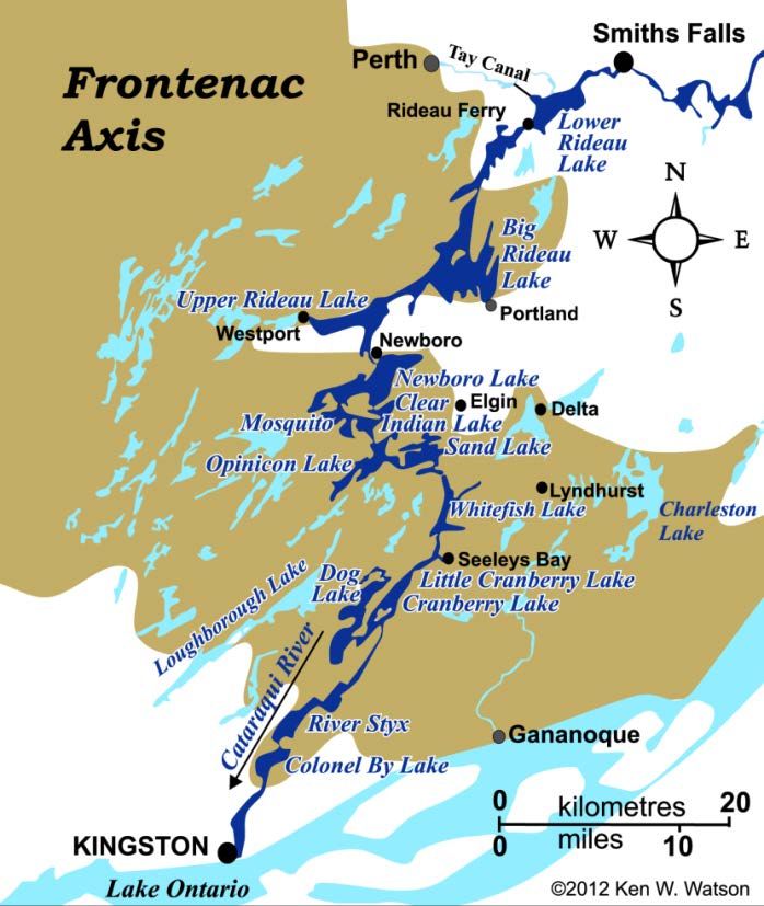
Watson’s 2019 Guide to the Rideau Canal                                                                    About the Guide

                                       About the Rideau Canal
The Rideau Canal is both a boater’s and land based visitor’s delight, attracting
boats from across North America and visitors from around the world to travel
its 202 kilometre (125 mile) length. The Rideau Canal, a UNESCO World
Heritage Site, a National Historic Site of Canada and a designated Canadian
Heritage River, consists of a series of beautiful lakes and rivers connected by
canals. It stretches from Kingston, at the foot of Lake Ontario, to Ottawa,
Canada's capital. Maintained by Canada's Parks service it is arguably the most
scenic and historic waterway in North America. Whether you visit by boat,
car, or bicycle, the Rideau has something for you.

The Rideau Canal, which links the lakes and rivers between Ottawa and
Kingston, is the oldest continuously operated canal in North America. The
locks are operated today much as they were when first opened in 1832. Each
lock is unique and the lock staff are always ready to offer the tourist any
assistance they can. Most locks provide washrooms, overnight mooring and
picnic facilities, including tables, benches and barbecue grills.

The Rideau Canal was designated a UNESCO World Heritage Site because it
is the best preserved example of a slackwater canal in North America
demonstrating the use of European slackwater technology in North America
on a large scale. It is the only canal dating from the great North American
canal-building era of the early 19th century that remains operational along its
original line with most of its original structures intact. The designation is also
for the fact that the Rideau Canal is an extensive, well preserved and
significant example of a canal which was used for a military purpose linked to a significant stage in human history – that of
the fight to control the north of the American continent.

You can visit the Rideau in a number of ways. A boat is of course best to get the full ambiance of the region. You can pilot
your own boat to the Rideau, trailer it here, or rent a boat on-site. Many people also enjoy the Rideau by staying at an Inn,
Bed & Breakfast, Lodge, or cabin. The Rideau also makes for a wonderful driving trip, with many scenic roads winding
their way through the heart of Old Ontario. So, whatever your vacation preference, the Rideau Canal has something for you.

                                            Acknowledgements
My thanks to the always-helpful staff of the Rideau Canal Office of Parks Canada, particularly Mary Ann Stienberg. My
thanks also to all those who have written about the Rideau, usually with an obvious passion for this unique waterway. I’ve
been trying to collect everything that has been put in print about the Rideau and I’m grateful to all these authors, many of
whom have obviously put a great deal of time and effort into the works they produced. These include such people as Robert
Legget, Larry Turner, Robert Passfield, Glenn Lockwood, Mary Fryer, Barbara Humphries, Mark Andrews, Clare
Churchill, Sue Warren, Clint Fleming, John Fleming, Ed Bebee, Kenneth Wells, Catherine Carroll, Elmer Lake, Dwight
Purdy, Deborah Gordanier, Catherine Carroll, Edwin Welch, Jenny Ryan, Coral Lindsay, Edward Bush, John Heisler,
Judith Tulloch, and I’m sure many others that I’ve missed.

Also my thanks to the Rideau visitor, many of whom have emailed me requesting information. It has often been this
prompting that has sparked growth in the website, to keep adding information, to keep improving the way the information
is presented.

Finally, my great thanks to those who have emailed me with a simple “thanks for the website”. This has been my greatest
reward for the work over the past few years that has gone into developing the website.

Ken W. Watson ( www.rideau-info.com )              version: January 17, 2019                                         Page 3
Watson’s 2019 Guide to the Rideau                                   Location Map

                                        Location Map

Ken W. Watson ( www.rideau-info.com )   version: January 17, 2019        Page 4
Watson’s 2019 Guide to the Rideau                                                                          Your Rideau Journey

                                   Your Rideau Journey – By Water
A Boat – Most types of boats can navigate the Rideau Canal. These include all kinds of pleasure craft; cruisers,
runabouts, canoes, kayaks, PWCs, rowing sculls, paddle boats, etc. The only restrictions are that a boat must be less than 90
feet long by 26 feet wide by 22 feet high and draught less than five feet (four feet for flat bottom boats with a width of 26
feet).

Safety Equipment – Boats must conform to Canadian Coast Guard rules. For details about these rules get a copy of the
free Safe Boating Guide, available from the Rideau Canal Office of Parks Canada or the Office of Boating Safety (see the
contact list). It is also available on-line by going to www.tc.gc.ca and searching for "Office of Boating Safety".

Charts – Hydrographical charts of the Rideau Canal are extremely useful to have on your Rideau journey. These charts, at
a scale of 1:20,000, with lockstation insets at 1:4,800, are the most detailed maps of the Rideau Canal. The charts show
water depths with the navigation channel, including location of the buoys, clearly marked. Two sets of charts cover the
Rideau Canal, Chart 1512 covers Ottawa to Smiths Falls and Chart 1513 covers Smiths Falls to Kingston. They are
available for purchase from several on-line retailers and at many of the lockstations.

Permits – Your vessel will require a lockage permit to go through a lock. These are available in a number of forms,
ranging from a single lockage pass to a full season permit. Prices are based on the length of your vessel. For more
information see the fees and schedules section of this document. They are available for purchase from Parks Canada or at
all lockstations.

General Information – You can obtain an information package from Parks Canada which includes the fee and hours of
operation schedule, a brochure with a map of the Rideau Canal and a listing of lockstation services, and other interesting
tourism information. This can be obtained by writing, emailing or phoning the Rideau Canal Office of Parks Canada (see
the contact list)

Books – Frankly, no trip is complete without a few good books about the area you are travelling through. A few that I
might recommend are the Rideau Boating, Road and Cottage Guide, an interesting geographically oriented travel guide of
the Rideau, a “must have” for all Rideau travellers (by water or road); Sailing Directions: Rideau Canal and Ottawa
River, this is a great navigation companion for your charts; and, of course no Rideau trip would be complete without, A
History of the Rideau Lockstations by Ken W. Watson, an historic visitors guide to each of the lockstations along the
Rideau Canal (all proceeds from the sale of this book go to Friends of the Rideau). All these books (and more) are available
at The Depot in Merrickville, operated during the summer by Friends of the Rideau and at select bookstores in the Rideau
Corridor.

Accommodation – Those travelling by vessels with enclosed accommodations have a great deal of choice. You can
moor overnight at any of the lockstations (for a fee), you can drop anchor in many of the quiet bays along the Rideau Canal
(for free) or stay at a full service marina (for a fee). For those of you without on-board facilities, you can pitch a tent at most
of the lockstations (see the lockstation listing), stay at one of the many campgrounds, or take advantage the variety of
B&Bs, Lodges, Inns, Motels or rental cottages.

Boat Launching – If you come to the Rideau Canal by water (along the St. Lawrence River, Lake Ontario or the
Ottawa River) this isn’t an issue. But if you trailer a boat to the Rideau Canal, you have many choices of where to launch
your boat. A good option is often a marina or campground where your vehicle and trailer will remain secure. However,
there are also many public boat-launching sites along the Rideau Canal. A full listing of both all the marinas and all the
boat launches can be found in this document.

Watch Your Waves (aka Watch Your Wake) – A problem in restricted channels and something that can give boaters
a bad name is the amount of wash generated by your boat. Several sections of the Rideau Canal have speed limits of 10 kph
(6 mph), these are clearly marked along the route. There are many problems with boat wash; it can swamp other boaters,
particularly those in small craft; it does property damage to shorelines, moored boats and docks; and it does aquatic habitat
damage (i.e. loon nests, muskrat dens). Recognize that you are sharing the waterway with a variety of other users, including

Ken W. Watson ( www.rideau-info.com )               version: January 17, 2019                                            Page 5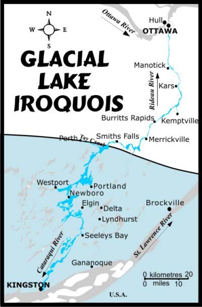
Watson’s 2019 Guide to the Rideau                                                                        Your Rideau Journey

local residents (both human and non-human). Basically it is just good courtesy to pay attention to the amount of wash your
vessel generates and its effect on other boaters and the shoreline. There are lots of open water spots on the Rideau Canal
where you can “let ‘er rip” should that need strike you. It is best to allow enough time for a tranquil trip, taking your time to
relax, enjoy the scenery and “make haste slowly”.

High Tech – if you can’t live without the latest gadgets on your trip, be aware of some limitations. With cellphones,
there are a few “dead zones” on the Rideau Canal. The location of these spots varies with the provider. As of this writing,
many marinas offer high speed Internet access (check first before you assume that you’ll get access). Many local libraries
also provide Internet access hot spots (most though only during operating hours).

                                   Your Rideau Journey – By Road
The area around the Rideau Canal is known as the Rideau Corridor. It is only 200 kilometres long, anchored by the historic
city of Kingston at the south end, and Canada’s national capital, Ottawa at the north end. It is easily travelled in a day, but
to get the full ambiance of the region it is best to plan for several days. A road travel guide has been included in the “Rideau
Communities” section of this guide.

Maps: Of course a detailed road map is a must. While most people today use a map on their smartphone or GPS, a paper
map is a good backup. The Government of Ontario road map or other commercial road map (i.e. Rand McNally) are good
options. The Government of Ontario road map is available as a series of PDF downloads from the Ministry of
Transportation website: www.mto.gov.on.ca/english/traveller/map/

Places to stay: There are many options in the Rideau Corridor; inns, lodges, campgrounds, B&Bs, etc. A listing of
campgrounds as well as links to places that list B&Bs, hotels and motels can be found on-line at:
                                   www.rideau-info.com/canal/accommodations.html

Sights to see: There are many sights to see in the corridor, the historic stone bridge in Lyndhurst, the Old Stone Mill in
Delta, the cheese shop in Forfar, the quaint shops of Westport, the historic town of Perth. The centre of the Rideau, Smiths
Falls, hosts the Rideau Canal Visitor Information Centre, the Smiths Falls Railway Museum and the Heritage House
Museum. The “Jewel of the Rideau,” Merrickville, with its stone heritage ambiance, the Blockhouse Museum, and
wonderful shops and Manotick with the historic Watson’s Mill. And, of course, there are the lovely lockstations which are
well worth a visit such as historic Kingston Mills, beautiful Jones Falls, quiet Nicholsons, scenic Long Island and the
spectacular flight of 8 locks in Ottawa.

Things to do: There are things to cater to most everyone’s interest – boating (lots of rental places), shopping, golfing,
nature viewing, heritage explorations, lovely picnic spots, hiking, and much more. A few ideas for various driving tours can
be found at: www.rideau-info.com/canal/driving/

Events: There are many events that take place on the Rideau every year – from the Smiths Falls Canal and Railway
Festival to Canalfest in Merrickville. For a full listing of these see the events link on www.rideauheritageroute.ca

Rideau Heritage Route – this route is marked with highway signs from Kingston to Ottawa. Following it is a great
way to explore the Rideau. Starting in Kingston, it heads north along County Road 15. Just past Seeleys Bay, you can take a
looping tour along County Roads 33 and 42, through Lyndhurst, Delta, Philipsville and Forfar. Or, continue north along
County Road 15 through Morton, past Elgin to Crosby. At Crosby there is another opportunity for a looping tour, heading
west along County Road 42 to Newboro and Westport, and then along County Road 10 to Perth and then back along
County Road 1, through Rideau Ferry, to Lombardy where you end up back on County Road 15. Or you could continue
along Hwy 15 from Crosby, through Portland-on-the-Rideau, to Lombardy. From Lombardy the route follows County Road
15 to Smiths Falls, then County Road 43 to Merrickville, County Road 23 to Kemptville and then north, across the Rideau
Canal to County Rd 5, to County Road 13, heading north along the west side of the Rideau River, to County Road 73 and
into Ottawa. A full driving itinerary and maps of this route can be found at: www.rideau-info.com/canal/driving/

Ken W. Watson ( www.rideau-info.com )               version: January 17, 2019                                           Page 6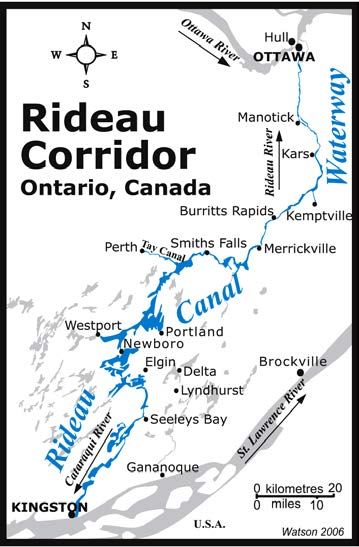
Watson’s 2019 Guide to the Rideau                                                                    Your Rideau Journey

         Your Rideau Journey – By Foot, Bicycle, Skate, Ski, Horse, or
There are many alternate ways to get around the Rideau. You can walk the Rideau Trail which extends from Kingston to
Ottawa. You can hike, ride, bicycle or ski the Cataraqui Trail, part of the Trans Canada Trail System. There is a hiking
guide on the website. Bicycle enthusiasts will find the many paved back roads fun to travel. There is a detailed guide to
cycling the Rideau on the website. Whatever your preferred mode of transportation, there is probably a way to do it within
the Rideau Corridor.

Ken W. Watson ( www.rideau-info.com )            version: January 17, 2019                                         Page 7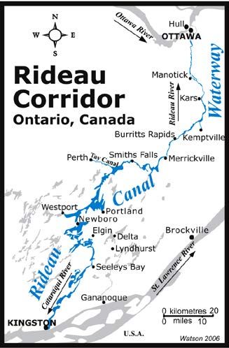
Watson’s 2019 Guide to the Rideau                                                                       Frequently Asked Questions

                                      Frequently Asked Questions
                                          www.rideau-info.com/canal/rideau-faq.html

Note: this is taken directly from the website and references to further information are to website locations. Some of the info, such as
marinas, boat launches and lockstation services are included in other sections of this document. For the paddler (canoeist/kayaker) there
is a separate Rideau Canal Paddling FAQ available on the www.rideau-info.com website.

                                             ABOUT THE RIDEAU CANAL

What is the Rideau Canal?
The Rideau Canal is a series of rivers, lakes and connecting locks and canals that form a continuous waterway from
Kingston to Ottawa, in eastern Ontario, Canada. It is 202 kilometres (125 miles) long, of which about 19 kilometres (12
miles) is man made (locks and canal cuts), the rest are natural waters. There are 45 locks in 23 lockstations along the main
route of the Rideau plus 2 locks that link the Tay Canal to the Rideau. From Lake Ontario at Kingston the canal rises 50.6
metres (166.2 feet) to the summit of Upper Rideau Lake and then descends 83.8 metres (275 feet) to the Ottawa River at
Ottawa. To view location maps, head over to: www.rideau-info.com/canal/maps.html.

Who Operates the Rideau Canal?
The Rideau Canal is operated by the Parks Canada Agency, which is under the authority of the Canadian government
Department of Environment. Parks Canada maintains the heritage aspects of the canal and operates it much like a park.

When and why was it built?
It was built between 1826 and 1832. It pre-dates the locks on the St. Lawrence, and was built to assist the defence of
Canada by allowing boats to travel from Montreal to the Great Lakes without having to travel down the St. Lawrence, in
gunshot range of the Americans. It was officially opened in May, 1832 and has been operated continuously ever since.

Who built it?
It was built by the British under the direction of Lt. Colonel John By of the Royal Engineers. Private contractors, such as
John Redpath and Thomas McKay, did most of the actual construction. The design and engineering of the canal was done
by Colonel By and the Royal Engineers. Two companies of Royal Sappers and Miners assisted in the construction.
Hundreds of tradesmen (i.e. masons, carpenters, smiths, coopers) used local materials to fashion the locks and dams. The
large amount of manual labour (i.e. digging & moving dirt, chopping trees, excavating stones) was done by hundreds of
immigrant Irish and French-Canadian labourers. Local settlers assisted with moving materials (i.e. stones) and providing
food to the construction camps. Some 2,500 to 4,000 men worked on the construction each year. Many women and
children were also part of these construction camps. For details about the construction, visit the History of the Rideau Canal
webpage at: www.rideau-info.com/canal/history/

What makes the Rideau Canal unique?
It is the oldest continuously operated canal in North America. Most of the locks are still operated by hand, using the same
mechanisms that were used to operate the locks in 1832. As you travel the Rideau Canal, you are viewing living history.
The Rideau isn't just a canal cut (only 10% is man-made), it's a waterway combining canals, rivers and lakes. This makes
the Rideau a wonderful blend of urban, rural and natural landscapes. You can see million dollar homes, quaint cottages, and
loons swimming in a sheltered, undisturbed bay, all in the same day.

How has the Rideau Canal been recognized?
In 1925 the Rideau Canal was designated a National Historic Site of Canada (plaqued in 1926, 1962 and 2013). In 2000 the
Rideau Canal was designated a Canadian Heritage River in recognition of its outstanding historical and recreational values.
In 2007 it was inscribed as a UNESCO World Heritage Site recognizing it as a work of human creative genius. The Rideau
Canal was recognized as the best preserved example of a slackwater canal in North America demonstrating the use of
European slackwater technology in North America on a large scale. It is the only canal dating from the great North
American canal-building era of the early 19th century that remains operational along its original line with most of its
original structures intact. It was also recognized as an extensive, well preserved and significant example of a canal which
was used for military purposes linked to a significant stage in human history - that of the fight to control the north of the
American continent.

Ken W. Watson ( www.rideau-info.com )                  version: January 17, 2019                                               Page 8
Watson’s 2019 Guide to the Rideau Frequently Asked Questions
BOATING THE RIDEAU CANAL
How big a boat do I need?
There is no minimum size of boat. The locks are operated for the tourist boater so the canal staff are used to handling any
type of boat whether it be a canoe, kayak, PWC, runabout or cruiser.
What are boat size restrictions?
The maximum size of boat is 27.4m/90ft. length, 7.9m/26ft. width, 6.7m/22ft height. Under special circumstances, the
Rideau Canal can accommodate a boat up to 33.5m (110ft) long by 9.1m (30ft) in width. The navigation channel, which is
clearly marked by buoys, maintains at least 1.5 metres (5 feet) of water under normal circumstances (the deepest part is in
Big Rideau Lake, which reaches a depth of 100.3 metres (329 feet)). Parks Canada asks that any boat drafting more than 1.2
metres (4 feet) to contact them before entering the canal. Minimum fixed bridge clearance is 6.7 metres (22 feet).
Is the Rideau Canal difficult to boat?
No - it's very easy. The Rideau Canal was built as a "slackwater" system, meaning there is no excessive current in the
rivers. Waves with some chop can develop on the bigger lakes but boaters can easily seek shelter near shore if the need
arises. Each lock has friendly canal staff who are used to dealing with novice boaters and will help out in any way they can.
Do I need a navigation chart?
Yes - there are two sets of navigation charts that cover the Rideau Canal. Chart 1512 covers from Ottawa to Smiths Falls
and Chart 1513 covers Smiths Falls to Kingston. These charts, in addition to showing the depth of the water in all the lakes
and rivers, clearly show the navigation channel and all the marker buoys. These charts can be purchased at most
lockstations or can be ordered on-line from Ontario Travel Guides www.ontariotravelguides.com/charts.htm.
When is the Rideau Canal open for boating?
The locks operate from mid-May to mid-October. For exact dates see the fees & schedules page located at: www.rideau-
info.com/canal/fees.html. Of course with so many sections of natural water, you can boat anytime there is open water.
Most of the lakes have launch ramp access. The longest "lock-free" stretch is the Long Reach, between Burritts Rapids and
Long Island, stretching for 40 kilometres (25 miles) along the Rideau River.
Do the locks operate 24 hours a day?
No - the hours vary. During most of the season the locks open at 9:00 am (10 am on weekdays during spring and fall). In
spring and fall, they close by 4:00 pm. In the summer they stay open until 6:00 pm from Mon to Thurs and until 7:00 pm
from Fri to Sun. Of note, last lockage is 30 minutes before closing for a single lock, 1 hour for a double lock, 1.5 hours for
a triple lock and 2 hours for a 4 lock lockstation. For full details see the fees & schedules page at: www.rideau-
info.com/canal/fees.html.
How long does it take to boat the Rideau Canal?
A one way trip can be done by a powerboat in as little as 4 to 5 days, but in reality you should plan at least 6 days each
way. A general rule of thumb is to assume 30 minutes for each lock and an average speed of 10 kph. So, with 202 km and
45 locks, that's 43 hours of travel time to get you from Lake Ontario to the Ottawa River. In summer, the lockstations are
open 9 hours a day - so that's 4.7 days. Presumably you'll want some additional time to sightsee, shop, swim, fish, etc. So,
look at the maps, figure out where you want to go, and do the math. Don’t rush, give yourself plenty of time to enjoy the
scenery and relax.
How much does it cost to go through the locks?
Parks Canada charges a fee by the foot (12 foot minimum). Based on current 2018 fees, if you just want to go through one
lock, it will cost $0.90 per foot. If you want to travel through locks for the whole season, you can buy a season lockpass for
$8.80 foot. There are various other options (one day, 6 day, one way transit). So, if you're in a 20 foot boat, a single lockage
would cost $18, and a full season lockpass would cost $176. For details see: www.rideau-info.com/canal/fees.html.
I'm in a small boat with no sleeping quarters - where can I overnight?
If you bring a tent, you can camp at most of the lockstations (a mooring permit gives you camping privileges). Parks
Canada also has oTENTiks at a few lockstations (Upper Brewers, Upper Beveridges & Upper Nicholsons). There are also
Ken W. Watson ( www.rideau-info.com ) version: January 17, 2019 Page 9Watson’s 2019 Guide to the Rideau Frequently Asked Questions
many B&Bs, Inns, and Lodges located along the shores of the Rideau Canal that will allow you to dock your boat and stay
at their place. Call ahead for reservations. For listings, check the accommodations page at:
www.rideau-info.com/canal/accommodations.html.
I'm in a big self-contained boat - where can I overnight?
You have many options. You can anchor your boat in one of the many sheltered bays. You can moor at most of the
lockstations for a mooring fee. For those wishing more services, most marinas offer dockage to transient boaters. Have a
look at the marinas page at: www.rideau-info.com/canal/marinas.html
Do I have to stock up on gas and supplies?
No - there are many services available along the Rideau Canal. There are lots of marinas so it's easy to get fuel. There are
several communities along the Rideau Canal that have grocery stores within easy walking distance of a docking area so you
can stock up on food, ice, drinks, etc. You'll find links to many of the towns, with maps and a listing of services from the
maps page at: www.rideau-info.com/canal/maps.html
I'm trailering a boat - where can I put in?
There are many boat launches along the Rideau Canal, some maintained by local communities, some at lock stations, some
at the provincial parks, some at campground and at most local marinas. A full list of boat launches can be found at:
www.rideau-info.com/canal/boat-launch.html (this listing is also included in this document). If you wish a secure spot to
leave your vehicle and trailer, then a marina or a campground is the best option. Most offer well maintained launch ramps,
accessible for a nominal fee. It is best to give them a call in advance, to get the details about storage for your vehicle and
trailer while you are enjoying your Rideau trip. Have a look at the campgrounds page: www.rideau-
info.com/canal/accom-camp.html or the marinas page: www.rideau-info.com/canal/marinas.html
Can I rent a boat?
Yes - there are a number of options. Those wishing to cruise the waterway may wish to rent a houseboat or a cruiser. Those
just interested in a day trip can rent a pontoon boat from one of the local marinas. Several of the local lodges, Inns and
B&Bs also offer boat rentals as part of their services. A listing of rentals and tours can be found on the boat rentals and
tours page at: www.rideau-info.com/canal/boat_rent.html
LAND BASED VISITORS
Do I need a boat to enjoy the Rideau Canal?
No - the locks are very pleasant places for visitors by car or foot to visit. Nice lawns with picnic tables make a great place
to enjoy a quiet lunch. The towns and villages along the Rideau Canal offer lots of opportunities for sightseeing and
shopping. Those interested in coming by vehicle should have a look at the driving tours pages: www.rideau-
info.com/canal/driving/
Is there a charge for using the lockstations?
Several of the lockstations have a nominal charge for parking ($1 to $4 per day). There is no charge for family/individual
day use of lockstation facilities although donations are appreciated. A full listing of fees can be found on the fees and
schedules page at: www.rideau-info.com/canal/fees.html
Can I camp at the locks?
Yes (except for Ottawa lockstation and Smiths Falls Combined lockstation). Anyone arriving by water, or by bicycle, or
people hiking recognized hiking trails may camp at a lockstation. Those arriving by water have access to one camping site
with the purchase of a mooring permit. Those arriving by bicycle, on foot, or by a boat that can be pulled from the water
(i.e. canoe/kayak) may purchase a camping permit. Those travelling by vehicle (car, RV, etc.) cannot stay overnight at the
locks unless renting an oTENTik. The lockstations offers lawns to pitch a tent, picnic tables, water, washroom facilities and
some have metal BBQ stands. There are no showers except for lockstations that offer oTENTiks (showers are available for
use by anyone with paid access to the Rideau Canal – lock pass, mooring pass or camping pass). A table showing the
facilities offered by each of the lockstations can be found at: www.rideau-info.com/canal/lock-services.html and a
camping FAQ can be found at: www.rideau-info.com/canal/lock-camping.html
Ken W. Watson ( www.rideau-info.com ) version: January 17, 2019 Page 10Watson’s 2019 Guide to the Rideau Frequently Asked Questions
If I come by car or RV, where can I overnight?
There are lots of accommodations along the Rideau Canal - B&Bs, Inns, Campgrounds, Cottages, etc. - take your pick. You
can find more information on the accommodations page at: www.rideau-info.com/canal/accommodations.html.
How can I get out on the water if I come by land?
You can take a boat with you (trailer, cartop, inflatable), rent a boat on-site, or take a boat tour. Information about boat
rentals and tours can be found on the boat rentals and tours page at: www.rideau-info.com/canal/boat_rent.html
CONTACTS
Rideau Canal Office, Parks Canada Friends of the Rideau Rideau Heritage Route
34 Beckwith St. South, P.O. Box 1232, Stn. Main Tourism Association
Smiths Falls, ON K7A 2A8 Smiths Falls, ON K7A 5C7 c/o Ann Weir
Tel: 613-283-5170 email: info@rideaufriends.com Economic Development Manager
Toll Free: 1-888-773-8888 (call centre) website: www.rideaufriends.com United Counties of Leeds and Grenville
Fax: 613-283-0677 32 Wall Street, Suite 300
email: RideauCanal-info@pc.gc.ca Brockville, ON K6V 4R9
website: www.pc.gc.ca/en/lhn-nhs/on/rideau Tel: 1-800-770-2170 Ext. 5365
email: info@rideauheritageroute.ca
website: www.rideauheritageroute.ca
Ken W. Watson ( www.rideau-info.com ) version: January 17, 2019 Page 11Watson’s 2019 Guide to the Rideau Fees and Schedules
Fees and Schedules
2019 Hours of Operation
Dates Days Hours
May 17 - June 23 Monday - Thursday 10:00 a.m. - 4:00 p.m.
Friday-Sunday, holidays 9:00 a.m. - 7:00 p.m.
June 24 - September 2 Monday - Thursday 9:00 a.m. - 6:00 p.m.
Friday-Sunday, holidays 9:00 a.m. - 7:00 p.m.
September 3 - October 14 Monday - Friday 10:00 a.m. - 4:00 p.m.
Saturday-Sunday, holidays 9:00 a.m. - 5:00 p.m.
The Caveats
• Times of the first and last lockages of the day, particularly at lockstations with multiple locks, are not guaranteed.
They are often affected by heavy boat traffic, water management and other station opening and closing duties of
the lock staff.
• To maximize chances of being locked through late in the day during regular hours, arrive early enough to allow for
complete lockages in both directions.
Last Lockage
• At a lockstation with one lock chamber, boaters must arrive at least 30 minutes before closing.
• At lockstations with two lock chambers, boaters must arrive at least one hour before closing.
• At lockstations with three lock chambers, boaters must arrive at least 1.5 hours before closing.
• At lockstations with four lock chambers, boaters must arrive at least two hours before closing.
• At Ottawa Locks, boaters must arrive at least 3.5 hours before closing.
• At swing bridges, boaters must arrive 20 minutes before closing.
Bridge Schedules
Most swing/lift bridges operate on an "on-demand" schedule. However, in some areas, a more rigid schedule is kept:
• Ottawa: swing/lift bridges remain closed during rush hour traffic from Monday to Friday; 8:30-9:00 am, 12:30-
1:15 pm, and 3:30-5:30 pm.
• Smiths Falls Bridge, from June 25 to August 15, opens at 8:45, 9:30, 10:15, 11:00, and 11:45 am. It operates on-
demand after 1:00 pm.
• Old Slys Bridge, remains closed during weekdays from 11:55 am to 12:15 pm and 12:45 to 1:00 pm.
• Perth's Beckwith Street Bridge swings on demand (check with the Beveridges lock staff first).
• Brass Point Bridge – on-demand during regular lockstation operating hours (see above)
• Kingston's Bascule Bridge open from 6 am to 10 pm and swings hour on the hour except for 8, 12, 4, 5 o'clock
on weekdays.
Ken W. Watson ( www.rideau-info.com ) version: January 17, 2019 Page 12Watson’s 2019 Guide to the Rideau Fees and Schedules
Maximum Overnight Mooring Period
Boaters are limited to 2 nights (48hrs) mooring at a lockstation - extensions are available at the discretion of the
lockmaster. Vessels having reached the maximum stay cannot return to the same wharf or wall for 24 hours, unless
otherwise directed by the lock staff.
Note: Overnight Mooring passes include one free camp site.
2019 Lockage, Mooring and Camping Fees (HST included)
Note: all figures are in $Canadian.
2019 Fees
Type of Permit
Single Lockage and Return $0.90/ft
One Day Lockage $1.60/ft
Six Day* $5.05/ft
Seasonal Lockage
(50% discount on seasonal lockage permits $8.80/ft
for canoes and kayaks)
Transit (one way) $4.65/ft
Overnight Mooring $0.90/ft
Seasonal Overnight Mooring $9.80/ft
Power** $9.80 per night
Group Camping $4.90 per person
oTENTiks $100 per night
* Allows passage through any number of locks on any six days.
** Power is available at Ottawa, Black Rapids, Burritts Rapids, Merrickville, Kilmarnock, Poonamalie,
Lower Beveridges, Narrows, Newboro, Davis, Chaffeys, Upper Brewers, and Lower Brewers
lockstations.
Note: these fees apply to the Rideau Canal, Trent-Severn Waterway and Sault Ste. Marie Canals. In
addition, the six day permits and seasonal lockage and mooring permits are valid for all the canals run
by Parks Canada in Ontario and Quebec (i.e. with a single season permit you could traverse all those
canals).
A minimum 12 foot vessel length charge will be made for boats 12 feet and under.
Purchase of a mooring permit includes one free tent site.
Payment can be made by VISA, Mastercard, personal cheque or cash at any lockstation. Advance
purchases can be made by contacting the Rideau Canal Office or by purchasing online via the Parks
Canada website.
Ken W. Watson ( www.rideau-info.com ) version: January 17, 2019 Page 13Watson’s 2019 Guide to the Rideau Fees and Schedules
Boat Launching and Parking*
Boat Launching
Per Launch (includes parking where applicable) $9.80
Season boat launching at Hogs Back, Poonamalie, Smiths Falls
$98.10
Detached, Edmunds and Beveridges Lockstations
Parking
Lockstation Hourly Daily Seasonal
Hogs Back --- $4.00 ---
Hartwells $1.00 (max 4 hours) -
Black Rapids $1.00 $4.00 ---
Long Island $1.00 $4.00 ---
Merrickville $1.00 $4.00
Edmunds --- $3.00 ---
$3.39 $203.40
Newboro ---
(Twp fees) (Twp fees)
Kingston Mills $1.00 $3.00 ---
* These fees are currently (2019) under review by Parks Canada.
Ken W. Watson ( www.rideau-info.com ) version: January 17, 2019 Page 14Watson’s 2019 Guide to the Rideau Locking Through
Locking Through
Locking through is the term used for a boat being locked up or down. It’s a simple procedure, boats (from canoes to cruise
ships) have been doing it since 1832 on the Rideau Canal, the procedure then much the same as it is today. Keep in mind
that the Rideau Canal is run by Parks Canada and caters to the recreational boater. The staff is friendly and always willing
to help visitors, including novice boaters.
In addition to the required safety equipment for your boat, it is advised that boats carry a full set of boat fenders (for both
sides of the boat), two boat hooks, and at least two good quality ropes for securing the bow and stern of the boat to the
canal drop cables. The ropes should be supple and about twenty feet in length. A good quality mooring line is best. In small
boats, plastic/metal paddles with a hooked top make good substitute boat hooks.
The basic procedure involves moving into the lock as indicated by the lock staff, looping bow and stern lines loosely
around the drop cables (plastic coated cables that are fastened to the top and bottom of the lock wall), waiting until the
water fills or empties from the lock, and then proceeding out when the doors open. Here are the specific procedures:
1. When you come into the lock area, tie up at the dock with the blue strip painted on it (this is the Blue Line Dock).
This is the dock for boats waiting to go through the lock. It is a good idea to put down fenders on both sides of
your boat since you don't know which side of the lock you will be instructed to use.
2. When the lock gates are open and any departing vessels are clear, the lock will be loaded. Pay attention to the lock
staff, they will specifically direct you on when to enter the lock and which side to go to. During busy times, the
lock can be filled with boats 3 or 4 across, and you in fact may end up in the middle, rather than on one side.
3. Proceed into the lock slowly. If there are two people on board, one should be positioned on the bow, with the bow
line ready and a boat hook handy in case the boat has to be fended off the wall. If there are more than two, one
should be positioned in the bow and one in the stern, with lines ready. Keep your boat under control. Be aware of
any crosswinds or currents.
4. Once in position on the wall, loop your bow and stern lines through the closest drop cables. DO NOT tie the line,
just loop it loosely around the cable and hold the end. Remember your boat will be traveling several metres up or
down in the lock, you don't want any lines tied to the wall.
5. Once you are in position in the lock, TURN OFF your ignition and any other engines on your boat, TURN OFF all
open flames, DO NOT smoke above or below vessel deck, and LEAVE ON your bilge blower.
6. During the lockage, if you are going up you may experience some turbulence in the lock as the water is let in.
Maintain control of your boat with your lines. You may wish to loop a line around a deck cleat to give you extra
leverage. Never leave a line unattended.
7. Be prepared to show your lockage permit to the staff, or be ready to purchase a permit from them.
8. When the lock operation is completed and the gates are fully open, the lock staff will direct you to restart your
engine. Make sure your bow and stern lines are back in your boat and proceed slowly under power out of the lock.
9. Adhere to any posted speed limits and watch out for swimmers and other boats.
For a simplified explanation of how exactly a lock works, visit the Friends of the Rideau website: www.rideaufriends.com
and have a look at their section on “How A Lock Works” (includes a downloadable brochure).
Ken W. Watson ( www.rideau-info.com ) version: January 17, 2019 Page 15Watson’s 2019 Guide to the Rideau Rideau Canal Route Statistics
Rideau Canal Statistics
Lock Dimensions (1) 41 metres / 134 feet long by 10 metres/33 feet wide
Available Water Depth (2) 1.5 metres / 5.0 feet (minimum)
Minimum Bridge Clearance (3) 6.7 metres/22.0 feet (minimum)
Total Locks (Kingston - Ottawa) 45 (47 including the 2 Tay Canal locks***)
Total Lockstations 23 (24 counting the Tay Canal)
Total Distance (Kingston - Ottawa) (4) 202.1 kilometres / 125.6 miles
Total Distance of Artificial Channels 19 kilometres / 12 miles
Lift - ascending Ottawa to Upper Rideau Lake 83.8 metres / 275 feet (in 31 locks)
Lift - descending Upper Rideau to Kingston 50.6 metres / 166.2 feet (in 14 locks)
Maximum Size of Vessel (5) 27.4m/90ft length, 7.9m/26ft width, 6.7m/22ft height
Transit Time (one way) 4 to 6 days
Maximum Depth of Water 100.3 metres (329 feet)
(1) This is the full length of the lock from the point of the upper sill to the point of the lower sill. The lock is actually 124
feet (37.8 m) long in the chamber, measured from the point of the lower sill to the face of the breastwork. The lower
gates require 13 feet (4.0 m) of room for their swing, so a vessel must be less than 111 feet (33.8 m) long. Since the
walls of the lock slope inwards, the internal width at the lower navigation water level in the locks is 31.5 feet (9.6 m)
(2) Normally the locks are maintained with a draught of 1.7 metres (5.5 feet). However even the 5 foot minimum is subject
to water availability and all vessels with a draught of over 1.2 metres (4 feet) should contact the Rideau Canal Office
prior to traversing the canal.
(3) This is the minimum fixed bridge clearance on the Rideau Canal proper. On the Tay Canal, the Craig Street fixed
bridge, at 2.1 metres/7 feet limits boats going right into downtown Perth (larger boats can tie up at Last Duel Park).
(4) Distances reflect the Rideau Canal proper. The Tay Canal, which is connected to the Rideau, extends from Lower
Rideau Lake to Perth, a distance of 10.0 kilometres (6.2 miles). Two locks (Lower Beveridges #33 & Upper
Beveridges #34) raise boats a total of 7.0 metres (22.9 feet) into the Tay Canal
(5) The Canal used to allow boats with a length of 33.5 metres (110 feet) and a width of 9.1 metres (30 feet) width to
traverse the system. If your vessel is less than these dimensions, but greater than the maximum shown in the chart,
contact the Rideau Canal Office
How the Locks Are Counted
When the canal was opened in May, 1832, there were 47 masonry locks that provided navigation from Kingston to Ottawa.
In reality, only 46 locks actually provided the navigation since one of the two locks at Hogs Back was (and still is) a guard
lock (a flood guard, it doesn't provide any lift). But that is picking nits, so we'll leave the count at 47. In the late 1880s, two
locks (Beveridges) were constructed at the entrance to the Tay Canal. Although not part of the Rideau Canal proper, they
are administered by the Rideau Canal Office - so although the number of locks required for Kingston to Ottawa navigation
didn't change, administratively, 2 more locks were added (total 49). In the 1970s, a new single lock (29a) replaced the flight
of 3 Smiths Falls Combined locks. This reduced the actual number of Kingston to Ottawa navigation locks to 45 and the
total locks administered by Parks Canada to 47. This is the situation today.
In terms of lockstations, the present day Kingston to Ottawa navigation lockstations number 23 - they are: Ottawa (8 locks
in flight), Hartwells (2 locks in flight), Hogs Back (1 lift lock, 1 guard lock), Black Rapids (1 lock), Long Island (3 locks
in flight), Burritts Rapids (1 lock), Nicholsons (2 detached locks), Clowes (1 lock), Merrickville (3 detached locks),
Kilmarnock (1 lock), Edmunds (1 lock), Old Slys (2 locks in flight), Smiths Falls Combined (1 lock), Smiths Falls
Detached (1 lock), Poonamalie (1 lock), Narrows (1 lock), Newboro (1 lock), Chaffeys (1 lock), Davis (1 lock), Jones
Falls (3 locks in flight, 1 detached), Upper Brewers (2 locks in flight), Lower Brewers (1 lock), Kingston Mills (3 locks
in flight, 1 detached). The lift statistics for those locks can be seen in the next section.
Parks Canada quotes 24 lockstations since they are counting in the Beveridges Lockstation (2 detached locks) of the Tay
Canal
Ken W. Watson ( www.rideau-info.com ) version: January 17, 2019 Page 16Watson’s 2019 Guide to the Rideau Rideau Canal Route Statistics
Rideau Canal - Route Statistics
Distance Distance
Lock Lift Bridge
km (miles) km (miles) Boat
Description metres Clearance Chart
from from Launch
(feet) metres (feet)
Ottawa Kingston
level=40.8m
0 (0) 202.1 (125.6) Ottawa River, Ottawa
(134 ft)
1512
0 (0) 202.1 (125.6) Ottawa Locks #1-8, in flight 24.1 (79.1)
#1
0.3 (0.2) 201.8 (125.4) Bridge - Plaza - Fixed 7.9 (25.6)
0.6 (0.4) 201.5 (125.2) Bridge - Mackenzie King - Fixed 8.2 (26.6)
0.9 (0.5) 201.2 (125.0) Bridge - Laurier Ave - Fixed 8.2 (26.6)
1.6 (1.0) 200.5 (124.6) Bridge – Corktown Foot Bridge - Fixed 8.2 (26.6)
2.4 (1.5) 199.7 (124.1) Bridge - Queensway - Fixed 7.1 (23)
3 (10) closed -
2.6 (1.6) 199.5 (124.0) Bridge 1 - Pretoria Ave - Vertical Lift
7 (22.7) open
4.5 (2.8) 197.6 (122.8) Bridge - Bank St. - Fixed 8.8 (28.5)
5.5 (3.4) 196.6 (122.2) Bridge - Bronson Ave - Fixed 6.7 (22.0)
6.7 (4.2) 195.4 (121.4) Hartwells Locks #9-10, in flight 6.5 (21.5)
8.2 (5.1) 193.9 (120.5) Bridge - Heron Rd - Fixed 8.5 (27.6)
8.4 (5.2) 193.7 (120.4) Hogs Back Locks #11-12, in flight (1 lift, 1 guard) 4.2 (13.8) X
8.4 (5.2) 193.7 (120.4) Bridge 4 - Hogs Back - Swing 2.9 (9.4)
11.9 (7.4) 190.2 (118.2) Bridge - CNR High Level - Fixed 9.5 (30.8)
13.5 (8.4) 188.6 (117.2) Bridge - Hunt Club - Fixed >16.0 (>50)
15.0 (9.3) 187.1 (116.3) Black Rapids Lock #13 2.9 (9.5)
16.0 (10.0) 186.1 (115.6) Park - Echo Lands X
20.7 (12.9) 181.4 (112.7) Park - Chapman Mills Conservation Area
21.0 (13.0) 181.1 (112.5) Bridge - Vimy Memorial - Fixed 6.7 (22)
1512
23.3 (14.5) 178.8 (111.1) Long Island Locks #14-16, in flight 7.6 (24.9)
#2
23.5 (14.6) 178.6 (111.0) Bridge 5 - Long Island - Swing 1.1 (3.6)
26.0 (16.2) 176.1 (109.4) Bridge - Manotick High Level - Fixed 6.7 (22)
36.5 (22.7) 165.6 (102.9) Bridge - Kars High Level - Fixed 6.7 (22)
37.4 (23.3) 164.7 (102.3) Kars Public Wharf X
39.9 (24.8) 162.2 (100.8) Park - W.A. Taylor Conservation Area X
44.6 (27.7) 157.5 (97.9) Park - Baxter Conservation Area
46.7 (29.0) 155.4 (96.6) Bridge - Hwy 16 High Level - Fixed 6.7 (22)
49.9 (31.0) 152.2 (94.6) Channel to Kemptville** 3.4 (11)**
50.9 (31.6) 151.2 (94.0) Park - Rideau River Provincial X
52.1 (32.4) 150.0 (93.2) Bridge - Beckett's High Level - Fixed 6.7 (22.0)
1512
64.0 (39.8) 138.1 (85.8) Burritts Rapids Lock #17 3.2 (10.5)
#3
65.1 (40.5) 137.0 (85.1) Bridge 9 - Burritts Rapids - Swing 3.2 (10.4)
69.4 (43.1) 132.7 (82.5) Lower Nicholsons Lock #18 2.0 (6.5)
69.7 (43.3) 132.4 (82.3) Upper Nicholsons Lock #19 2.3 (7.6)
69.7 (43.3) 132.4 (82.3) Bridge 10 - Upper Nicholsons - Swing 3.6 (11.7)
70.5 (43.8) 131.6 (81.8) Clowes Lock #20 2.3 (7.6)
Ken W. Watson ( www.rideau-info.com ) version: January 17, 2019 Page 17Watson’s 2019 Guide to the Rideau Rideau Canal Route Statistics
Distance Distance
Lock Lift Bridge
km (miles) km (miles) Boat
Description metres Clearance Chart
from from Launch
(feet) metres (feet)
Ottawa Kingston
73.2 (45.5) 128.9 (80.1) Bridge - Merrickville - C.P.R. - Fixed 11.9 (39)
73.8 (45.9) 128.3 (79.7) Merrickville Lock #21 2.6 (8.7)
74.0 (46.0) 128.1 (79.6) Merrickville Lock #22 3.0 (10)
74.2 (46.1) 127.9 (79.5) Merrickville Lock #23 2.0 (6.2)
74.2 (46.1) 127.9 (79.5) Bridge 11 - Merrickville - Swing 2.9 (9.5)
74.7 (46.4) 127.4 (79.2) Lion's Park - Merrickville X
86.7 (53.9) 115.4 (71.7) Kilmarnock Lock #24 0.7 (2.3)
86.7 (53.9) 115.4 (71.7) Bridge 13 - Kilmarnock - Swing 2.9 (9.5)
92.7 (57.6) 109.4 (68.0) Edmunds Lock #25 2.8 (9.2) X
95.4 (59.3) 106.7 (66.3) Bridge - C.P.R. Railway - Fixed 9.1 (30)
95.4 (59.3) 106.7 (66.3) Old Slys Locks #26-27, in flight 4.9 (16.1)
95.6 (59.4) 106.5 (66.2) Bridge 15 - Olds Slys - Swing 2.2 (7.1)
96.8 (60.2) 105.3 (65.4) Bridge - Beckwith Street - Fixed 7.9 (26)
Replaces old
96.8 (60.2) 105.3 (65.4) Smiths Falls Combined Lock #29a 7.6 (25.6)
locks 28-30
97.0 (60.3) 105.1 (65.3) Victoria Park - Smiths Falls
97.4 (60.5) 104.7 (65.1) Bridge 19 - Abbot Street - Swing 1.9 (6.2)
97.4 (60.5) 104.7 (65.1) Smiths Falls Detached Lock #31 2.6 (8.5) X
Permanently
97.5 (60.6) 104.6 (65.0) Bridge - C.N.R. - Bascule
open
1513
102.2 (62.8) 101.0 (62.8) Poonamalie Lock #32 2.2 (7.2) X
#1
103.0 (64.0) 99.1 (61.6) Entrance to Lower Rideau Lake
To Perth =
107.5 (66.8) 94.6 (58.8) Diversion to Tay Canal Tay Canal =
10.0 km
110.4 (68.6) 91.7 (57.0) Tay Canal Entrance – Lower Rideau Lake
Tay 0.3 (0.2) Tay 0.3 (0.2) Lower Beveridges Lock #33 3.6 (12) X
Tay 0.5 (0.3) Tay 0.5 (0.3) Bridge – Beveridges – Fixed 6.7 (22)
Tay 0.9 (0.6) Tay 0.9 (0.6) Upper Beveridges Lock #34 3.3 (10.9)
Tay 9.2 (5.7) Tay 9.2 (5.7) Last Duel Park, Wharf – Perth X
Tay 9.3 (5.8) Tay 9.3 (5.8) Bridge – Craig Street, Perth – Fixed 2.1 (7)
Tay 9.8 (6.1) Tay 9.8 (6.1) Bridge – Beckwith Street, Perth – Swing 1.6 (5.2)
Tay 9.8 (6.1) Tay 9.8 (6.1) Bridge – Drummond Street – Fixed 2.9 (9.5)
Tay 10.0 (6.2) Tay 10.0 (6.2) Perth Basin – Public Wharf
Tay 10.1 (6.3) Tay 10.1 (6.3) Bridge – Gore Street, Perth - Fixed 2.7 (9)
110.6 (68.7) 91.5 (56.9) Rideau Ferry Yacht Club Conservation Area X
111.7 (69.4) 90.6 (56.3) Public Dock, Rideau Ferry
111.7 (69.4) 90.6 (56.3) Bridge 26 - Rideau Ferry - Fixed 8.0 (26.0)
119.4 (74.2) 82.7 (51.4) Park - Murphys Point Provincial Park X
1513
123.1 (76.5) 79.0 (49.1) Diversion to Portland
#2
126.8 (78.8) 75.3 (46.8) Colonel By Island (Livingston Island)
133.6 (83.0) 68.5 (42.6) Portland Public Wharf
Ken W. Watson ( www.rideau-info.com ) version: January 17, 2019 Page 18Watson’s 2019 Guide to the Rideau Rideau Canal Route Statistics
Distance Distance
Lock Lift Bridge
km (miles) km (miles) Boat
Description metres Clearance Chart
from from Launch
(feet) metres (feet)
Ottawa Kingston
133.6 (83.0) 68.5 (42.6) Park - John McKenzie, Portland X
132.4 (82.3) 69.7 (43.3) Narrows Lock #35 0.8 (2.6)
132.4 (82.3) 69.7 (43.3) Bridge 27 - The Narrows - Swing 1.2 (3.9)
1513
133.9 (83.2) 68.2 (42.4) Diversion to Westport
#2,3
140.8 (87.5) 61.3 (38.1) Westport Public Wharf
140.2 (87.1) 61.9 (38.5) Bridge - Newboro High Level - Fixed 8.2 (27)
140.8 (87.5) 61.3 (38.1) Newboro Lock #36 2.7 (8.9)
140.7 (87.4) 61.4 (38.2) Newboro Public Wharf X
1513
146.0 (90.7) 56.1 (34.9) Ferry - cable (auto/foot)
#3
148.2 (92.1) 53.9 (33.5) Bridge - C.N.R. High Level - Fixed 9.1 (29.5)
148.7 (92.4) 53.4 (33.2) Chaffeys Lock #37 3.4 (11.2) X
148.7 (92.4) 53.4 (33.2) Bridge 30 - Chaffey's - Swing 1.8 (5.9)
152.0 (94.5) 50.1 (31.1) Davis Lock #38 2.7 (8.9)
158.4 (98.4) 43.7 (27.2) Bridge – Jones Falls - Fixed 7.0 (22.7)
1513
159.0 (98.8) 43.1 (26.8) Jones Falls Lock #39 4.2 (13.7)
#4
159.2 (98.9) 42.9 (26.7) Jones Falls Locks #40-42, in flight 13.2 (43.4)
161.4 (100.3) 40.7 (25.3) Diversion to Morton
165.6 (102.9) 36.5 (22.7) Morton Dam
166.2 (103.3) 35.9 (22.3) Diversion to Seeleys Bay
167.2 (103.9) 34.9 (21.7) Seeleys Bay Public Wharf X
170.0 (105.6) 32.1 (19.9) Bridge 36 - Brass Point - Swing 1.2 (3.9)
176.5 (109.7) 25.6 (15.9) Upper Brewers Locks #43-44, in flight 5.9 (19.4)
177.0 (110.0) 25.1 (15.6) Bridge - Sunbury Rd. - Fixed 6.7 (22.0)
179.3 (111.4) 22.8 (14.2) Bridge 39 - Lower Brewers - Swing 1.3 (4.2)
179.3 (111.4) 22.8 (14.2) Lower Brewers (Washburn) Lock #45 4.0 (13.1)
195.0 (121.2) 7.1 (4.4) Bridge 41 - Kingston Mills - Swing 2.3 (7.5)
195.2 (121.3) 7.1 (4.4) Kingston Mills Lock #46 3.0 (9.8)
195.2 (121.3) 6.9 (4.3) Kingston Mills Locks #47-49, in flight 10.7 (35.2)
195.2 (121.3) 6.9 (4.3) Bridge - C.N.R. High Level - Fixed 8.2 (26.6)
196.0 (121.8) 6.1 (3.8) Bridge - Hwy 401 - Fixed 6.7 (22.0)
202.1 (125.6) 0 (0) Kingston Lasalle Causeway *** 4.3 (14)***
202.1 (125.6) 0 (0) Kingston Lasalle - Bascule Lift Bridge*** 0.6 (2)***
elevation:
Lake Ontario 74m (242.8
ft)
* Additional boat launch ramps can be found at private marinas.
** Kemptville Creek is shallow; Kemptville bridge clearance 2.1 m (6.8 ft)
*** Small craft under 4.3 m (14 ft) vertical clearance may pass through La Salle Causeway by using boat channels at its
eastern end.
Ken W. Watson ( www.rideau-info.com ) version: January 17, 2019 Page 19You can also read