Annual Operating Plan for Colorado River Reservoirs 2021 - Bureau of Reclamation
←
→
Page content transcription
If your browser does not render page correctly, please read the page content below
Annual Operating Plan for
Colorado River Reservoirs
2021

U.S. Department of the Interior   December 9, 2020

THE SECRETARY OF THE INTERIOR
                                             WASHINGTON

                                       JAN 08 2021

The Honorable Jared Polis
Governor of Colorado
Denver, Colorado 80203

Dear Governor Polis:

Enclosed is the Annual Operating Plan (AOP) for Colorado River System Reservoirs for 2021.
The AOP contains the projected plan of operation of Colorado River reservoirs for 2021 based
on the most probable runoff conditions. The plan of operation reflects the use of the reservoirs
for all purposes consistent with the Criteria for Coordinated Long-Range Operation of Colorado
River Reservoirs Pursuant to the Colorado River Basin Project Act of September 30, 1968. The
2021 AOP incorporates the Colorado River Interim Guidelines for Lower Basin Shortages and
the Coordinated Operations for Lake Powell and Lake Mead (2007 Interim Guidelines), the
Lower Basin Drought Contingency Plan Agreement (LB DCP Agreement), and Minute No. 323
of the United States and Mexican Sections of the International Boundary and Water Commission
(IBWC).

The AOP was prepared by the Bureau of Reclamation in consultation with representatives of the
Governors of the seven Colorado River Basin States; representatives from Mexico; the Upper
Colorado River Commission; Native American Tribes; appropriate Federal agencies;
representatives of the academic and scientific communities, environmental organizations, and
recreation industry; water delivery contractors; contractors for the purchase of Federal power;
others interested in Colorado River operations; and the general public, through the Colorado
River Management Work Group (Work Group). The Work Group held meetings on June 1, 2020,
July 23, 2020, and September 3, 2020.

The water year 2021 release from Lake Powell is projected to be 9.00 million acre-feet (maf)
(11,100 million cubic meters [mcm]). Given the hydrologic variability of the Colorado River
System and based on actual 2020 water year operations, the projected water year release from
Lake Powell in 2021 is likely to be in the range of 8.23 maf (10,150 mcm) to 9.00 maf
(11,100 mcm) or greater.

Water deliveries in the Lower Basin during the calendar year 2021 will be limited to 7.5 maf
(9,250 mcm) plus or minus any credits for Intentionally Created Surplus (ICS). The 2007 Interim
Guidelines adopted the ICS mechanism that, among other things, encourages the efficient use
and management of Colorado River water in the Lower Basin. The ICS may be created and
delivered in 2021 pursuant to the 2007 Interim Guidelines, the LB DCP Agreement, and
appropriate forbearance and delivery agreements.
The LB DCP Agreement will also govern the operation of Lake Mead for calendar year 2021.
Consistent with sections III.B.1.a and III.B.2.a of exhibit 1 to the LB DCP Agreement, DCP
contributions will be required by Arizona and Nevada, respectively, in calendar year 2021.

In addition to Lower Basin deliveries, a volume of 1.500 maf (1,850 mcm) of water will be
scheduled for delivery to Mexico during the calendar year 2021 in accordance with article 15 of
the 1944 United States-Mexico Water Treaty and Minutes No. 242 and 322 of the IBWC. The
volume delivered will be adjusted for water savings contributions as required under section IV of
IBWC Minute No. 323. In accordance with IBWC Minute No. 323, Mexico may create water
for, or take delivery of water from, Mexico’s Water Reserve pursuant to section V of IBWC
Minute No. 323. Inflow to Lake Powell has been below average in 16 of the past 21 years (2000
through 2020). Accordingly, all water users in the Colorado River Basin are encouraged to
prudently manage the use of available supplies.

The Department of the Interior continues to closely monitor water supply conditions in the
Colorado River Basin and looks forward to continuing to work with your representatives and
other interested parties regarding the management of this vital river system.

                                            Sincerely,

                                            Secretary of the Interior

Enclosure
TABLE OF CONTENTS
INTRODUCTION ...................................................................................................... 1
Background ........................................................................................................... 1
Authority ................................................................................................................ 2
Purpose ................................................................................................................. 3
Summary of Projected 2021 Operations ............................................................... 4
Upper Basin ....................................................................................................... 4
Lower Basin ....................................................................................................... 4
1944 United States-Mexico Water Treaty .......................................................... 5
2020 HYDROLOGY SUMMARY AND RESERVOIR STATUS ................................ 6
2021 WATER SUPPLY ASSUMPTIONS ................................................................. 8
SUMMARY OF RESERVOIR OPERATIONS IN 2020 AND PROJECTED 2021
RESERVOIR OPERATIONS .................................................................................. 10
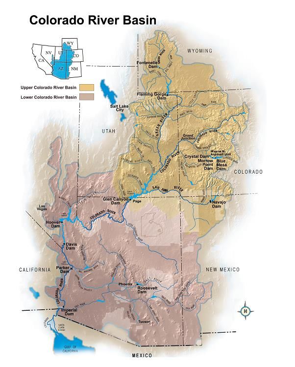
Fontenelle Reservoir ........................................................................................... 11
Flaming Gorge Reservoir .................................................................................... 11
Blue Mesa, Morrow Point, and Crystal Reservoirs (Aspinall Unit) ....................... 14
Navajo Reservoir ................................................................................................. 15
Lake Powell ......................................................................................................... 16
Lake Mead .......................................................................................................... 19
Lakes Mohave and Havasu ................................................................................. 20
Bill Williams River ................................................................................................ 21
Senator Wash and Laguna Reservoirs................................................................ 22
Imperial Dam ....................................................................................................... 22
Gila River Flows .................................................................................................. 23
Warren H. Brock Reservoir ................................................................................. 23
Yuma Desalting Plant .......................................................................................... 23
Off-stream Storage Agreements ......................................................................... 24
Intentionally Created Surplus .............................................................................. 24
Extraordinary Conservation ICS ...................................................................... 24
System Efficiency ICS ..................................................................................... 25
Tributary Conservation ICS ............................................................................. 25
Imported ICS ................................................................................................... 25
Binational ICS. ................................................................................................. 25
DCP ICS. ......................................................................................................... 26
System Conservation .......................................................................................... 26
Delivery of Water to Mexico ................................................................................ 26
2021 DETERMINATIONS....................................................................................... 29
Upper Basin ........................................................................................................ 29
Lower Basin ........................................................................................................ 30
1944 United States-Mexico Water Treaty............................................................ 32
DISCLAIMER ......................................................................................................... 33
ACRONYMS AND ABBREVIATIONS.................................................................... 34
ii 2021 AOP – December 9, 2020LIST OF TABLES
Table 1. Reservoir Conditions on October 1, 2020 (English Units) ................... 7
Table 2. Reservoir Conditions on October 1, 2020 (Metric Units)...................... 7
Table 3. Projected Unregulated Inflow into Lake Powell for Water Year 2021
(English Units) ................................................................................................. 9
Table 4. Projected Unregulated Inflow into Lake Powell for Water Year 2021
(Metric Units) .................................................................................................... 9
Table 5. Summary of Extraordinary Conservation ICS Plans of Creation in
Calendar Years 2020 and 2021 ..................................................................... 25
iii 2021 AOP – December 9, 2020INTRODUCTION
Background
Each year’s Annual Operating Plan (AOP) for Colorado River Reservoirs reports on both the
past operations of the Colorado River reservoirs for the completed year as well as projected
operations and releases from these reservoirs for the current (i.e., upcoming) year.
Accordingly, this 2021 AOP reports on 2020 operations as well as projected operations for
2021. In recent years, additions to the Law of the River such as operational rules, guidelines,
and decisions have been put into place for Colorado River reservoirs including the 1996 Glen
Canyon Dam Record of Decision1 (ROD), the Operating Criteria for Glen Canyon Dam,2 the
1999 Off-stream Storage of Colorado River Water Rule (43 CFR Part 414),3 the 2001 Interim
Surplus Guidelines4 addressing operation of Hoover Dam, the 2006 Flaming Gorge Dam
ROD,5 the 2006 Navajo Dam ROD6 to implement recommended flows for endangered fish, the
2007 Interim Guidelines for the operations of Lake Powell and Lake Mead,7 the 2012 Aspinall
ROD,8 the 2016 Glen Canyon Dam Long-Term Experimental and Management Plan (LTEMP)
ROD,9 Minute No. 323 between the United States and Mexican Sections of the International
Boundary and Water Commission (IBWC),10 and the agreements related to the 2019 Colorado
1
ROD for the Operation of Glen Canyon Dam, October 9, 1996. Available online at:
https://www.usbr.gov/uc/envdocs/rod/Oct1996_OperationGCD_ROD.pdf.
2
Following the implementation of the LTEMP ROD, the Glen Canyon Dam operating criteria were revised and
are in effect in water years 2019 and 2020 and available online at:
https://www.usbr.gov/uc/water/crsp/studies/GCOC.pdf.
3
Off-stream Storage of Colorado River Water; Development and Release of Intentionally Created Unused
Apportionment in the Lower Division States: Final Rule (43 CFR Part 414; 64 Federal Register 59006,
November 1, 1999). Available online at: https://www.usbr.gov/lc/region/g4000/contracts/FinalRule43cfr414.pdf.
4
ROD for the Colorado River Interim Surplus Guidelines, January 16, 2001 (67 Federal Register 7772, January
25, 2001). Available online at: https://www.usbr.gov/lc/region/g4000/surplus/surplus_rod_final.pdf.
5
ROD for the Operation of Flaming Gorge Dam, February 16, 2006. Available online at:
https://www.usbr.gov/uc/envdocs/rod/fgFEIS/final-ROD-15feb06.pdf.
6
ROD for Navajo Reservoir Operations, Navajo Unit – San Juan River, New Mexico, Colorado, Utah, July 31,
2006. Available online at: https://www.usbr.gov/uc/envdocs/eis/navajo/pdfs/NavWaterOpsROD2006.pdf.
7
ROD for Colorado River Interim Guidelines for Lower Basin Shortages and the Coordinated Operations for Lake
Powell and Lake Mead (73 Federal Register 19873, April 11, 2008). The ROD adopting the 2007 Interim
Guidelines was signed by the Secretary on December 13, 2007. Available online at:
https://www.usbr.gov/lc/region/programs/strategies/RecordofDecision.pdf.
8
ROD for the Aspinall Unit Operations, Final Environmental Impact Statement, April 2012. Available online at:
https://www.usbr.gov/uc/envdocs/eis/AspinallEIS/ROD.pdf.
9
ROD for the Glen Canyon Dam Long-Term Experimental and Management Plan Final Environmental Impact
Statement, December 2016. Available online at: http://ltempeis.anl.gov/documents/docs/LTEMP_ROD.pdf.
10
IBWC Minute No. 323, Extension of Cooperative Measures and Adoption of a Binational Water Scarcity
Contingency Plan in the Colorado River Basin dated September 21, 2017. Available online at:
https://www.ibwc.gov/Files/Minutes/Min323.pdf.
1 2021 AOP – December 9, 2020River Drought Contingency Plans (DCPs)11 as authorized by Public Law 116-14.12 Each AOP
incorporates these and other rules, guidelines, and decisions, and reports on how the criteria
contained in the applicable decision document or documents are implemented. Thus, the AOP
makes projections and reports on how the Bureau of Reclamation (Reclamation) will
implement these decisions in response to changing water supply conditions as they unfold
during the upcoming year, when conditions become known. Congress has charged the
Secretary of the Interior (Secretary) with stewardship and responsibility for a wide range of
natural, cultural, recreational, and tribal resources within the Colorado River Basin. The
Secretary has the authority to operate and maintain Reclamation facilities within the Colorado
River Basin addressed in this AOP to help manage these resources and accomplish their
protection and enhancement in a manner fully consistent with applicable provisions of Federal
law including the Law of the River, applicable provisions of State law, and other project-
specific operational limitations.
The Secretary recognized in the 2007 Interim Guidelines that the AOP provides an integrated
report on reservoir operations affected by numerous federal policies: "The AOP is used to
memorialize operational decisions that are made pursuant to individual federal actions (e.g.,
ISG [the 2001 Interim Surplus Guidelines], 1996 Glen Canyon Dam ROD, this [2007 Interim
Guidelines] ROD). Thus, the AOP serves as a single, integrated reference document required
by section 602(b) of the CRBPA of 1968 [Colorado River Basin Project Act of September 30,
1968 (Public Law 90-537)]13 regarding past and anticipated operations."
Authority
This 2021 AOP was developed in accordance with the processes set forth in: Section 602 of
the CRBPA; the Criteria for Coordinated Long-Range Operation of Colorado River
Reservoirs Pursuant to the Colorado River Basin Project Act of September 30, 1968
(Public Law 90-537) (Operating Criteria), as amended, promulgated by the Secretary;14 and
Section 1804(c)(3) of the Grand Canyon Protection Act of 1992 (Public Law 102-575).15
Section 602(b) of the CRBPA requires the Secretary to prepare and “transmit to the Congress
and to the Governors of the Colorado River Basin States a report describing the actual
operation under the adopted criteria [i.e., the Operating Criteria] for the preceding compact
water year and the projected operation for the current year.”
This AOP has been developed consistent with: the Operating Criteria; applicable Federal laws;
the Utilization of Waters of the Colorado and Tijuana Rivers and of the Rio Grande, the Treaty
11
The agreements related to the 2019 Colorado River DCPs, as authorized by Public Law 116-14, were executed
on May 20, 2019 and consist of an Upper Basin DCP (Drought Response Operations and Demand Management
Storage) and a Lower Basin DCP including Lower Basin Drought Operations. Available online at:
https://www.usbr.gov/lc/region/programs/dcp.html.
12
The Colorado River Drought Contingency Plan Authorization Act (Public Law 116-14) was signed into law on
April 16, 2019. Available online at: https://www.congress.gov/116/bills/hr2030/BILLS-116hr2030enr.pdf.
13
Available online at: https://www.usbr.gov/lc/region/pao/pdfiles/crbproj.pdf.
14
Available online at: https://www.usbr.gov/lc/region/g4000/lroc/frmar2905.pdf.
15
Available online at: https://www.usbr.gov/uc/legal/gcpa1992.pdf.
2 2021 AOP – December 9, 2020Between the United States of America and Mexico, signed February 3, 1944 (1944 United
States-Mexico Water Treaty);16 interstate compacts; court decrees; the Colorado River Water
Delivery Agreement;17 the 2007 Interim Guidelines; the 2019 Colorado River DCP agreements;
and other documents relating to the use of the waters of the Colorado River, which are
commonly and collectively known as the Law of the River.
The 2021 AOP was prepared by Reclamation on behalf of the Secretary, working with other
Interior agencies and the Western Area Power Administration (WAPA). Reclamation
consulted with the seven Colorado River Basin States Governors’ representatives,
representatives from Mexico, the Upper Colorado River Commission (UCRC), Native
American tribes, other appropriate Federal agencies, representatives of academic and scientific
communities, environmental organizations, representatives of the recreation industry, water
delivery contractors, contractors for the purchase of Federal power, others interested in
Colorado River operations, and the general public through the Colorado River Management
Work Group.
Article I(2) of the Operating Criteria allows for revision of the projected plan of operation to
reflect current hydrologic conditions with notification to the Congress and the Governors of the
Colorado River Basin States of any changes by June of each year. The process for revision of
the AOP is further described in Section 7.C of the 2007 Interim Guidelines. Any revision to
the final AOP may occur only through the AOP consultation process as required by applicable
Federal law.
Purpose
The purpose of the AOP is to report on the past year’s operations and illustrate the potential
range of reservoir operations that might be expected in the upcoming year, and to determine or
address: (1) the quantity of water considered necessary to be in storage in the Upper Basin
reservoirs as of September 30, 2021, pursuant to Section 602(a) of the CRBPA; (2) water
available for delivery pursuant to the 1944 United States-Mexico Water Treaty and Minutes
No. 242,18 322,19 and 323 of the IBWC; (3) whether the reasonable consumptive use
requirements of mainstream users in the Lower Division States will be met under a “Normal,”
“Surplus,” or “Shortage” Condition as outlined in Article III of the Operating Criteria and as
implemented by the 2007 Interim Guidelines; (4) whether management and/or operational
regimes will be required or considered as described in the 2019 Colorado River DCP; and (5)
whether water apportioned to, but unused by one or more Lower Division States, exists and can
be used to satisfy beneficial consumptive use requests of mainstream users in other Lower
16
Available online at: https://www.ibwc.gov/Files/1944Treaty.pdf.
17
Colorado River Water Delivery Agreement: Federal Quantification Settlement Agreement for Purposes of
Section 5(B) of Interim Surplus Guidelines, October 10, 2003 (69 Federal Register 12202, March 15, 2004).
Available online at: https://www.usbr.gov/lc/region/g4000/crwda/crwda.pdf.
18
IBWC Minute No. 242, Permanent and Definitive Solution to the International Problem of the Salinity of the
Colorado River dated August 30, 1973. Available online at: https://www.ibwc.gov/Files/Minutes/Min242.pdf.
19
IBWC Minute No. 322, Extension of the Temporary Emergency Delivery of Colorado River Water for use in
Tijuana, Baja California dated January 19, 2017. Available online at:
https://www.ibwc.gov/Files/Minutes/Minute_322_1.pdf.
3 2021 AOP – December 9, 2020Division States as provided in the Consolidated Decree of the Supreme Court of the United
States in Arizona v. California, 547 U.S. 150 (2006) (Consolidated Decree).20
Consistent with the above determinations and in accordance with other applicable provisions of
the Law of the River, the AOP was developed with “appropriate consideration of the uses of
the reservoirs for all purposes, including flood control, river regulation, beneficial consumptive
uses, power production, water quality control, recreation, enhancement of fish and wildlife, and
other environmental factors” (Operating Criteria, Article I(2)).
Since the hydrologic conditions of the Colorado River Basin can never be completely known in
advance, the AOP presents projected operations resulting from three different hydrologic
scenarios: the minimum probable, most probable, and maximum probable reservoir inflow
conditions. Projected reservoir operations are modified during the water year as runoff
forecasts are adjusted to reflect existing snowpack, basin storage, flow conditions, and as
changes occur in projected water deliveries.
Summary of Projected 2021 Operations
Upper Basin. Taking into account (1) the existing water storage conditions in the basin, (2)
the August 2020 24-Month Study21 projection of the most probable near-term water supply
conditions in the basin, and (3) Section 6.B of the 2007 Interim Guidelines, the Upper
Elevation Balancing Tier will govern the operation of Lake Powell for water year 2021. The
August 2020 24-Month Study of the most probable inflow scenario projects the water year
2021 release from Glen Canyon Dam to be 9.00 million acre-feet (maf) (11,100 million cubic
meters [mcm]). Given the hydrologic variability of the Colorado River System and based on
actual 2020 water year operations, the projected water year release from Lake Powell in 2021 is
likely to be in the estimated range of 8.23 maf (10,150 mcm) to 9.00 maf (11,100 mcm) or
greater.
For further information about the variability of projected inflow into Lake Powell, see the 2021
Water Supply Assumptions section and the Lake Powell section within the Summary of
Reservoir Operations in 2020 and Projected 2021 Reservoir Operations, and Tables 3 and 4.
Lower Basin. Taking into account (1) the existing water storage conditions in the basin, (2)
the most probable near-term water supply conditions in the basin, and (3) Section 2.B.5 of the
2007 Interim Guidelines, the Intentionally Created Surplus (ICS) Surplus Condition will govern
the operation of Lake Mead for calendar year 2021 in accordance with Article III(3)(b) of the
Operating Criteria and Article II(B)(2) of the Consolidated Decree. In addition, the Lower
Basin Drought Contingency Plan Agreement (LB DCP Agreement) will also govern the
operation of Lake Mead for calendar year 2021. Consistent with Sections III.B.1.a and
20
Available online at: https://www.usbr.gov/lc/region/pao/pdfiles/scconsolidateddecree2006.pdf.
21
The 24-Month Study refers to the operational study conducted by Reclamation to project future reservoir
operations. The most recent 24-Month Study report is available on Reclamation’s Water Operations websites and
is updated each month. Available online at: https://www.usbr.gov/uc/water/crsp/studies/index.html and
https://www.usbr.gov/lc/region/g4000/24mo/index.html.
4 2021 AOP – December 9, 2020III.B.2.a of Exhibit 1 to the LB DCP Agreement, DCP contributions will be required by
Arizona and Nevada, respectively, in calendar year 2021.
No unused apportionment for calendar year 2021 is anticipated. If any unused apportionment
becomes available after adoption of this AOP, Reclamation, on behalf of the Secretary, may
allocate any such available unused apportionment for calendar year 2021. Any such allocation
shall be made in accordance with Article II(B)(6) of the Consolidated Decree, the Lower
Colorado Region Policy for Apportioned but Unused Water22 (Unused Water Policy), and
giving further consideration to the water conservation objectives of the July 30, 2014
agreement for a pilot system conservation program (PSCP)23 and as specified in Section 4.b of
the LB DCP Agreement.
In calendar year 2021, Colorado River water may be stored off-stream pursuant to individual
Storage and Interstate Release Agreements (SIRAs) and 43 CFR Part 414 within the Lower
Division States. The Secretary shall make Intentionally Created Unused Apportionment
(ICUA) available to contractors in Arizona, California, or Nevada pursuant to individual SIRAs
and 43 CFR Part 414.
The Inadvertent Overrun and Payback Policy (IOPP),24 which became effective January 1,
2004, will be in effect during calendar year 2021.
Conserved Colorado River water, created through the PSCP25 and other voluntary agreements,
is anticipated to be added to Lower Basin reservoirs pursuant to system conservation
agreements in the Lower Basin in calendar year 2021.
The 2007 Interim Guidelines adopted the ICS mechanism, which was expanded upon in the LB
DCP Agreement, that among other things encourages the efficient use and management of
Colorado River water in the Lower Basin. ICS may be created and delivered in calendar year
2021 pursuant to the 2007 Interim Guidelines, applicable forbearance and delivery agreements,
and the LB DCP Agreement.
1944 United States-Mexico Water Treaty. A volume of 1.50 maf (1,850 mcm) of water will
be available to be scheduled for delivery to Mexico during calendar year 2021 in accordance
with Article 15 of the 1944 United States-Mexico Water Treaty and Minutes No. 242 and 322
of the IBWC. The volume delivered will be adjusted for water savings contributions as
required under Section IV of IBWC Minute No. 323. In accordance with IBWC Minute No.
323, Mexico may create water for or take delivery of water from Mexico’s Water Reserve
pursuant to Section V of IBWC Minute No. 323.
22
Lower Colorado Region Policy for Apportioned but Unused Water, February 11, 2010. Available online at:
https://www.usbr.gov/lc/region/g4000/UnusedWaterPolicy.pdf.
23
Available online at:
https://www.usbr.gov/lc/region/programs/PilotSysConsProg/PilotSCPFundingAgreement7-30-2014.pdf.
24
ROD for Implementation Agreement, Inadvertent Overrun and Payback Policy, and Related Federal Actions,
Final Environmental Impact Statement, October 10, 2003 (69 Federal Register 12202, March 15, 2004).
Available online at: https://www.usbr.gov/lc/region/g4000/crwda/crwda_rod.pdf.
25
More information about the PSCP in the Lower Basin can be found at:
https://www.usbr.gov/lc/region/programs/PilotSysConsProg/pilotsystem.html.
5 2021 AOP – December 9, 20202020 HYDROLOGY SUMMARY AND RESERVOIR STATUS
Below average stream flows were observed throughout much of the Colorado River Basin
during water year 2020. Unregulated26 inflow to Lake Powell in water year 2020 was 5.85 maf
(7,220 mcm), or 54 percent of the 30-year average27 which is 10.83 maf (13,360 mcm).
Unregulated inflow to Flaming Gorge, Blue Mesa, and Navajo Reservoirs was 86, 64, and 40
percent of average, respectively.
Precipitation in the Upper Colorado River Basin was below average28 during water year 2020.
On September 30, 2020, the cumulative precipitation received within the Upper Colorado River
Basin for water year 2020 was 77 percent of average.
Snowpack conditions trended near average29 across most of the Colorado River Basin
throughout the snow accumulation season. The basin-wide snow water equivalent measured
107 percent of median on April 1, 2020, which is the same date the total seasonal accumulation
peaked. On April 1, 2020, the snow water equivalents for the Green River, Upper Colorado
River Headwaters, and San Juan River Basins were 110, 115, and 96 percent of median,
respectively.
During the 2020 spring runoff period, inflows to Lake Powell peaked on June 5, 2020 at
approximately 42,500 cubic feet per second (cfs) (1,200 cubic meters per second [cms]). The
April through July unregulated inflow volume for Lake Powell was 3.76 maf (4,640 mcm)
which was 52 percent of average.
Lower Basin tributary inflows above Lake Mead were below average for water year 2020.
Tributary inflow measured at the Little Colorado River near Cameron gage for water year 2020
totaled 0.092 maf (113 mcm), or 64 percent of average. Tributary inflow measured at the
Virgin River at Littlefield gage for water year 2020 totaled 0.138 maf (170 mcm), or 76 percent
of average.
Below Hoover Dam, tributary inflow for water year 2020 measured at the Bill Williams River
below Alamo Dam gage totaled 0.083 maf (102 mcm), and tributary inflow measured at the
Gila River near Dome gage totaled 0.0070 maf (9.0 mcm).30
The Colorado River total system storage experienced a net decrease of 2.75 maf (3,390 mcm)
in water year 2020. Reservoir storage in Lake Powell decreased during water year 2020 by
26
Unregulated inflow adjusts for the effects of operations at upstream reservoirs. It is computed by adding the
change in storage and the evaporation losses from upstream reservoirs to the observed inflow. Unregulated inflow
is used because it provides an inflow time series that is not biased by upstream reservoir operations.
27
Inflow statistics throughout this document will be compared to the mean of the 30-year period 1981-2010,
unless otherwise noted.
28
Precipitation statistics throughout this document are provided by the National Weather Service’s Colorado Basin
River Forecast Center and are based on the mean for the 30-year period 1981-2010, unless otherwise noted.
29
Snowpack and snow water equivalent statistics throughout this document are provided by the Natural Resources
Conservation Service and are based on the median for the 30-year period 1981-2010, unless otherwise noted.
30
Tributary inflows from the Bill Williams River and Gila River to the mainstream are very sporadic. These flows
occur very seldom and when they do they are typically of high magnitude.
6 2021 AOP – December 9, 20201.91 maf (2,360 mcm). Reservoir storage in Lake Mead increased during water year 2020 by
0.018 maf (22 mcm). At the beginning of water year 2020 (October 1, 2019), Colorado River
total system storage was 53 percent of capacity. As of September 30, 2020, total system
storage was 48 percent of capacity.
Tables 1 and 2 list the October 1, 2020, reservoir vacant space, live storage, water elevation,
percent of capacity, change in storage, and change in water elevation during water year 2020.
Table 1. Reservoir Conditions on October 1, 2020 (English Units)
Vacant Live Water Percent of Change in Change in
Reservoir
Space Storage Elevation Capacity Storage* Elevation*
(maf) (maf) (ft) (%) (maf) (ft)
Fontenelle 0.087 0.258 6,494.55 75 -0.013 -1.8
Flaming Gorge 0.555 3.19 6,025.93 85 -0.215 -5.6
Blue Mesa 0.390 0.439 7,470.42 53 -0.297 -38.4
Navajo 0.546 1.15 6,043.32 68 -0.239 -19.8
Lake Powell 12.95 11.37 3,595.98 47 -1.91 -19.4
Lake Mead 15.84 10.28 1,083.21 39 0.018 0.2
Lake Mohave 0.285 1.52 636.50 84 -0.049 -1.9
Lake Havasu 0.066 0.554 446.61 89 -0.046 -2.4
Totals 30.72 28.77 48 -2.75
* From October 1, 2019, to September 30, 2020 .
Table 2. Reservoir Conditions on October 1, 2020 (Metric Units)
Vacant Live Water Percent of Change in Change in
Reservoir
Space Storage Elevation Capacity Storage* Elevation*
(mcm) (mcm) (m) (%) (mcm) (m)
Fontenelle 107 318 1,979.54 75 -16 -0.5
Flaming Gorge 685 3,930 1,836.70 85 -265 -1.7
Blue Mesa 481 541 2,276.98 53 -366 -11.7
Navajo 673 1,420 1,842.00 68 -295 -6.0
Lake Powell 15,970 14,020 1,096.05 47 -2,360 -5.9
Lake Mead 19,540 12,680 330.16 39 22 0.1
Lake Mohave 352 1,870 194.00 84 -60 -0.6
Lake Havasu 81 683 136.13 89 -57 -0.7
Totals 37,890 35,490 48 -3,390
* From October 1, 2019, to September 30, 2020.
7 2021 AOP – December 9, 20202021 WATER SUPPLY ASSUMPTIONS
For 2021 operations, three reservoir unregulated inflow scenarios were developed and
analyzed: minimum probable, most probable, and maximum probable.
There is considerable uncertainty associated with streamflow forecasts and projections of
reservoir operations made a year in advance. The National Weather Service’s Colorado Basin
River Forecast Center (CBRFC) forecasts the inflow for the minimum probable (90 percent
exceedance), most probable (50 percent exceedance), and maximum probable (10 percent
exceedance) inflow scenarios using an Ensemble Streamflow Prediction model. Based upon
the August CBRFC forecast, the range of unregulated inflows is projected to be as follows:
• The forecasted minimum probable unregulated inflow to Lake Powell in water year
2021 is 5.20 maf (6,410 mcm), or 48 percent of average.
• The forecasted most probable unregulated inflow to Lake Powell in water year 2021 is
8.70 maf (10,730 mcm), or 80 percent of average.
• The forecasted maximum probable unregulated inflow to Lake Powell in water year
2021 is 16.50 maf (20,350 mcm), or 152 percent of average.
Projected unregulated inflow volumes into Lake Powell for specific time periods for these three
forecasted inflow scenarios are shown in Tables 3 and 4.
Inflows to the mainstream from Lake Powell to Lake Mead, Lake Mead to Lake Mohave, Lake
Mohave to Lake Havasu, and below Lake Havasu are projected using historic data over the
five-year period of January 2015 through December 2019, inclusive. These five years of
historic data are representative of the most recent hydrologic conditions in the Lower Basin.
The most probable side inflows into each reach are estimated as the arithmetic mean of the
five-year record. The maximum probable and minimum probable projections for each reach
are the 10 percent and 90 percent exceedance values, respectively, of the five-year record. For
the reach from Lake Powell to Lake Mead, the minimum probable inflow during water year
2021 is 0.766 maf (945 mcm), the most probable inflow is 0.878 maf (1,080 mcm), and the
maximum probable inflow is 1.04 maf (1,280 mcm).
The projected monthly volumes of inflow were input into the 24-Month Study and used to
project potential reservoir operations for 2021. Starting with the August 2020 24-Month Study
projection of the October 1, 2021 reservoir storage conditions, the projected monthly releases
for each reservoir were adjusted until release and storage levels best accomplished project
purposes and applicable operational objectives.
For the latest monthly projections for the major reservoirs in the Colorado River system, please
see the most recent 24-Month Study report available on these Reclamation websites:
https://www.usbr.gov/uc/water/crsp/studies/index.html, or
https://www.usbr.gov/lc/region/g4000/24mo/index.html.
8 2021 AOP – December 9, 2020Table 3. Projected Unregulated Inflow into Lake Powell for Water Year 2021
(English Units)31
Minimum Most Maximum
Time
Probable Probable Probable
Period
(maf) (maf) (maf)
10/2020 – 12/2020 1.07 1.13 1.41
1/2021 – 3/2021 1.12 1.12 1.71
4/2021 – 7/2021 2.70 5.74 11.91
8/2021 – 9/2021 0.31 0.71 1.46
10/2021 – 12/2021 1.03 1.25 1.71
WY 2021 5.20 8.70 16.49
CY 2021 5.16 8.82 16.79
Table 4. Projected Unregulated Inflow into Lake Powell for Water Year 2021
(Metric Units)
Minimum Most Maximum
Time
Probable Probable Probable
Period
(mcm) (mcm) (mcm)
10/2020 – 12/2020 1,320 1,390 1,740
1/2021 – 3/2021 1,380 1,380 2,110
4/2021 – 7/2021 3,330 7,080 14,690
8/2021 – 9/2021 380 880 1,800
10/2021 – 12/2021 1,270 1,540 2,110
WY 2021 6,410 10,730 20,340
CY 2021 6,360 10,880 20,710
31
All values in Tables 3 and 4 are projected inflows based upon the August 2020 CBRFC forecast. The CBRFC
Most Probable forecast is issued as monthly values. The CBRFC Minimum and Maximum Probable forecasts are
issued as water year totals, which Reclamation disaggregates to monthly values using monthly proportions of the
10th and 90th percentiles, respectively, of the 1981-2010 unregulated inflow.
9 2021 AOP – December 9, 2020SUMMARY OF RESERVOIR OPERATIONS IN 2020 AND
PROJECTED 2021 RESERVOIR OPERATIONS
The operation of the Colorado River reservoirs has affected some aquatic and riparian
resources. Controlled releases from dams have modified temperature, sediment load, and flow
patterns, resulting in increased productivity of some riparian and non-native aquatic resources
and the development of economically significant sport fisheries. However, these same releases
can have detrimental effects on endangered and other native species. Operating strategies
designed to protect and enhance aquatic and riparian resources have been established after
appropriate National Environmental Policy Act compliance at several locations in the Colorado
River Basin.
In the Upper Basin, public stakeholder work groups have been established at Fontenelle Dam,
Flaming Gorge Dam, the Aspinall Unit, and Navajo Dam. These work groups provide a public
forum for dissemination of information regarding ongoing and projected reservoir operations
throughout the year and allow stakeholders the opportunity to provide information and
feedback with respect to ongoing reservoir operations. Additionally, the Glen Canyon Dam
Adaptive Management Work Group (AMWG)32 was established in 1997 as a chartered
committee under the Federal Advisory Committee Act of 1972 (Public Law 92-463).
Modifications to projected operations are routinely made based on changes in forecasted
conditions or other relevant factors. Within the parameters set forth in the Law of the River
and consistent with the Upper Colorado River Endangered Fish Recovery Program (UCRIP),33
the San Juan River Basin Recovery Implementation Program (SJRIP),34 Section 7 consultations
under the Endangered Species Act, and other downstream concerns, modifications to projected
monthly operations may be based on other factors in addition to changes in streamflow
forecasts. Decisions on spring peak releases and downstream habitat target flows may be made
midway through the runoff season. Reclamation will conduct meetings with Recovery
Program participants, the U.S. Fish and Wildlife Service (Service), other Federal agencies,
representatives of the Basin States, and with public stakeholder work groups to facilitate the
discussions necessary to finalize site-specific projected operations.
The following paragraphs discuss reservoir operations in 2020 and the range of probable
projected 2021 operations of each of the reservoirs with respect to applicable provisions of
compacts, the Consolidated Decree, statutes, regulations, contracts, and instream flow needs for
maintaining or improving aquatic and riparian resources where appropriate.
32
Information on the AMWG can be found at: https://www.usbr.gov/uc/progact/amp/amwg.html.
33
Information on the UCRIP can be found at: http://coloradoriverrecovery.org.
34
Information on the SJRIP can be found at: https://www.fws.gov/southwest/sjrip.
10 2021 AOP – December 9, 2020Fontenelle Reservoir
Reservoir storage in Fontenelle decreased during water year 2020. At the beginning of water
year 2020, Fontenelle storage was 79 percent of live capacity at elevation 6,496.36 feet
(1,980.09 meters), with 0.271 maf (334 mcm) in storage. The unregulated inflow to Fontenelle
during water year 2020 was 0.996 maf (1,230 mcm) which is 92 percent of average. At the end
of the water year, September 30, 2020, Fontenelle storage was at 75 percent of live capacity at
elevation 6,494.55 feet (1,979.54 meters), with a storage of 0.258 maf (318 mcm) resulting in a
net decrease during water year 2020 of 0.013 maf (16 mcm).
Hydrologic conditions in the Upper Green River Basin above Fontenelle were below average in
water year 2020. Snowpack development tracked above median with average fall conditions
maintaining soil moisture resulting in near average runoff forecasts. Peak snow water
equivalent reached 116 percent of seasonal median on April 18, 2020. The observed inflow
during the April to July season was 0.677 maf (835 mcm), or 93 percent of average.
Fontenelle Reservoir filled in water year 2020. The reservoir elevation peaked at 6,504.20 feet
(1,982.48 meters) on July 18, 2020, which was 2.40 feet (0.73 meters) below the spillway crest.
Daily inflow peaked at 9,140 cfs (259 cms) on June 9, 2020. Reservoir releases were made to
balance downstream water resources needs and power production, while also allowing for
filling the reservoir to maintain sufficient water in storage for use through the fall and winter
months. Releases peaked at 4,060 cfs (115 cms) on June 16, 2020 and were reduced to 900 cfs
(25.5 cms) in September.
Based on the August 2020 24-Month Study, the most probable April through July inflow
scenario for Fontenelle Reservoir during water year 2021 is 0.645 maf (796 mcm) or 89 percent
of average. This volume exceeds the 0.295 maf (364 mcm) storage capacity of Fontenelle
Reservoir. For this reason, the most probable and maximum probable inflow scenarios would
require releases during the spring that exceed the capacity of the powerplant to avoid
uncontrolled spills from the reservoir. It is likely that Fontenelle Reservoir will fill during
water year 2021. In order to minimize high spring releases and to maximize downstream water
resources and power production, the reservoir will most likely be drawn down to about
elevation 6,468.35 feet (1,971.55 meters) by early March 2021, which is 5.35 feet (1.63 meters)
above the minimum operating level for power generation, and corresponds to a volume of
0.112 maf (138 mcm) of live storage.
Flaming Gorge Reservoir
Reservoir storage in Flaming Gorge decreased during water year 2020. At the beginning of
water year 2020, Flaming Gorge storage was 91 percent of live capacity at elevation 6,031.57
feet (1,838.42 meters), with 3.41 maf (4,210 mcm) in storage. The unregulated inflow to
Flaming Gorge during water year 2020 was 1.25 maf (1,540 mcm) which is 86 percent of
average. At the end of the water year, Flaming Gorge storage was at 85 percent of live capacity
at elevation 6,025.93 feet (1,836.70 meters), with 3.19 maf (3,930 mcm) resulting in a net
decrease during water year 2020 of 0.215 maf (265 mcm).
11 2021 AOP – December 9, 2020Flaming Gorge Dam operations in 2020 were conducted in compliance with the 2006 Flaming
Gorge ROD. Reclamation convened the Flaming Gorge Technical Working Group (FGTWG)
comprised of Service, WAPA, and Reclamation personnel. The FGTWG proposed that
Reclamation manage releases to the Green River to meet the commitments of the 2006 Flaming
Gorge ROD and, to the extent possible, meet the experimental design parameters outlined in
the UCRIP Larval Trigger Study Plan (LTSP) for the benefit of endangered razorback sucker.35
Larvae were detected on May 19, 2020. After public notification, releases from Flaming Gorge
Dam were increased to full powerplant capacity on May 26, 2020. Bypass releases were
utilized to bring the total release from Flaming Gorge Dam to 8,600 cfs (243 cms) for 4 days,
starting on May 27, 2020, to enhance floodplain operations in the middle Green River for the
benefit of endangered species.
In total, Flaming Gorge Dam released at or above powerplant capacity releases of 4,600 cfs
(130 cms) for 13 days during the April through July runoff period. Yampa River flows at the
Deerlodge gage during the LTSP peaked at 11,400 cfs (323 cms) on June 3, 2020. The peak
release from Flaming Gorge Dam occurred before the Yampa River peak to support larval
entrainment and reservoir management during the high spring inflows. Flows measured on the
Green River at the Jensen, Utah gage reached levels at or above 14,000 cfs (396 cms) for 12
days between May 29 and June 9, 2020 with a peak of 17,600 cfs (498 cms) on June 4, 2020.
The LTSP target for this hydrologic classification is greater than or equal to 14,000 cfs (396
cms) and a peak magnitude of up to 18,600 cfs (526 cms) for 7 or more days.
Hydrologic conditions in the Upper Green River Basin above Flaming Gorge were below
average in water year 2020 even though snowpack development tracked just above median
with average fall conditions maintaining soil moisture resulting in near average runoff
forecasts. Peak snow water equivalent reached 113 percent of seasonal median on April 18,
2020. The May forecast for the April through July inflow into Flaming Gorge Reservoir was
0.880 maf (1,090 mcm), or 85 percent of average. The observed inflow during the April to July
season was 0.833 maf (1,030 mcm), or 85 percent of average.
Observed flow volumes from the Yampa River Basin were significantly different than
projected flow volumes from the Upper Green River Basin and fell into the average hydrologic
condition. The 2006 Flaming Gorge ROD hydrologic classification for the Upper Green was
characterized as average. The flexibility in the ROD allows for a change in hydrology
classification two higher and one lower than that designated by the forecasted unregulated
inflow volume on May 1 depending upon Yampa River conditions. It was determined that the
hydrologic classification was average and the LTSP hydrologic classification was average
(below median) based on the May forecast. Flows at Jensen met 2006 Flaming Gorge ROD
flow targets in Reach 2 for the ROD Flow Recommendation of at least 14,000 cfs (396 cms) for
12 days.
Consistent with the 2006 Flaming Gorge ROD, considering information provided to the
FGTWG, average hydrologic conditions and in response to the Recovery Program’s request,
Reclamation operated Flaming Gorge Dam to produce flows in Reach 2 to assist in the
35
The LTSP’s primary objective is to determine the effects of timing of Flaming Gorge spring release on
razorback sucker larvae in the reach below the confluence of the Green and Yampa Rivers. The LTSP Report is
available online at: https://www.usbr.gov/uc/water/crsp/wg/fg/twg/twgSummaries.html.
12 2021 AOP – December 9, 2020recovery of Colorado Pikeminnow during the summer of 2020. The 2006 Flaming Gorge ROD
base flow period hydrologic classification was average as of July 2020. The August observed
unregulated inflow resulted in a Moderate Dry hydrologic classification. Daily base flows
fluctuated during the summer to meet 2,000 to 2,600 cfs (56.6 to 73.6 cms) in July and August
and 1,800 to 2,000 cfs (51.0 to 60.6 cms) in September on the Green River at Jensen, Utah.
The Flaming Gorge Operation Plan for May 2020 through April 2021 (FG-Ops) has been
developed and approved by Reclamation. The FG-Ops outlines the UCRIP request that
includes the LTSP36 experiments for the razorback sucker (spring peak period), and Colorado
pikeminnow37 proposed flows within the confines of the 2000 Flow and Temperature
Recommendations (summer base flow period). The FG-Ops includes a plan release schedule
for moderately dry, average (below and above median) and moderately wet scenarios for the
spring peak flows, summer-autumn base flows, and winter base flow periods. The summer-
autumn and winter base flows periods followed the 2000 Flow and Temperature
Recommendations.38
Under the August 2020 most probable inflow scenario, winter base flow releases are projected
to be in the average classification range with a 25 percent increase above the average daily base
flows calculated through the base flow period. Winter releases are projected to be
approximately 1,150 cfs (32.5 cms). Daily base flows will likely fluctuate during the winter in
response to hydropower needs during December through February and meet the average-year
reservoir upper level drawdown elevation target of 6,027.00 feet (1,837.03 meters) by May 1,
2021. A spring peak release is projected to occur in May or June 2021 and will be timed to
coincide with either the peak flows of the Yampa River or emergence of razorback sucker
larvae. Reclamation is considering long-term implementation strategies for the Recovery
Program LTSP.
Based on the August 2020 24-Month Study, the most probable April through July unregulated
inflow scenario for Flaming Gorge Reservoir during water year 2021 is 0.845 maf (1,040 mcm)
or 86 percent of average. The peak elevation is expected to be approximately 6,029.63 feet
(1,837.83 meters) near mid-July 2021. By the end of water year 2021, Flaming Gorge
Reservoir is projected to be at elevation 6,028.19 feet (1,837.39 meters), with a storage of 3.28
maf (4,050 mcm), or 87 percent of capacity.
The UCRIP, in coordination with Reclamation, the Service, and WAPA, will continue
conducting studies associated with floodplain inundation. Such studies may result in
alternatives for meeting flow and temperature recommendations at lower peak flow levels
where feasible.
36
Available online at: http://www.coloradoriverrecovery.org/documents-publications/technical-
reports/isf/BestgenHillFR-BWtopoGreenRiverpikeminnowreportFinalFebruary2016.pdf.
37
Colorado pikeminnow study does not have an approved study plan, and is implemented within the confines of
2000 Flow and Temperature. Bestgen, K.R. and A. Hill. 2016. Reproduction, abundance, and recruitment
dynamics of young Colorado pikeminnow in the Green and Yampa rivers, Utah and Colorado, 1979-2012. Larval
Fish Laboratory Contribution 183. https://www.coloradoriverrecovery.org/documents-publications/technical-
reports/isf/BestgenHillFR-BWtopoGreenRiverpikeminnowreportFinalFebruary2016.pdf
38
Flow and Temperature Recommendations for Endangered Fishes in the Green River Downstream of Flaming
Gorge Dam, September 2000. Available online at: http://www.coloradoriverrecovery.org/documents-
publications/technical-reports/isf/flaminggorgeflowrecs.pdf.
13 2021 AOP – December 9, 2020Blue Mesa, Morrow Point, and Crystal Reservoirs (Aspinall Unit)
Reservoir storage content in Blue Mesa decreased during water year 2020. At the beginning of
water year 2020, Blue Mesa storage content was 89 percent of live capacity at elevation
7,508.84 feet (2,288.69 meters), with 0.736 maf (908 mcm) in storage content. The
unregulated inflow to Blue Mesa during water year 2020 was 0.608 maf (750 mcm) which was
64 percent of average. At the end of the water year, Blue Mesa storage content was 53 percent
of live capacity at elevation 7,470.42 feet (2,276.98 meters), with 0.439 maf (541 mcm)
resulting in a net decrease during water year 2020 of 0.297 maf (366 mcm).
Near average snowpack conditions occurred during the winter months of water year 2020 in the
Gunnison River Basin. Snow measurement sites in the basin reported near average seasonal
snow water equivalent levels throughout the winter and into the spring of 2020 resulting in an
April 1, 2020 snow water equivalent for the Gunnison River Basin that was 97 percent of
average.
The fall through winter releases from Crystal Dam varied between approximately 1,450 cfs
(41.0 cms) in November 2019 to 600 cfs (17.0 cms) in February 2020. On March 19,
2020, releases from Crystal Dam were increased for operation of the Gunnison Tunnel. Flows
through the Black Canyon were maintained within the range of approximately 450 cfs (12.7
cms) to approximately 1,412 cfs (40.0 cms) until May 15, 2020.
The May 2020 final forecast for the unregulated inflow to Blue Mesa for the April through July
runoff period was 0.450 maf (555 mcm) which was 67 percent of average. This forecast was
used to establish the hydrologic category for water year 2020 as Moderately Dry with a peak
flow target established for the Whitewater reach of the Gunnison River of 5,396 cfs (153 cms)
for 1 day.
On May 15, 2020, releases from Crystal, Morrow Point and Blue Mesa were increased to target
downstream flow levels and durations described in the Aspinall ROD and the Black Canyon
Water Right Decree.39 On May 18, 2020, while releases from Aspinall were being increased to
meet the downstream peak flow target, the mid-month forecast was issued and the April
through July unregulated inflow forecast for Blue Mesa was reduced to 0.395 maf (487 mcm)
which was 59 percent of average. Based on the updated forecast the peak flow target was
reduced to 3,167 cfs (89.6 cms) for 1 day. During spring peak operations, flows measured in
the Whitewater Reach of the Gunnison River achieved an average daily peak flow of 4,510 cfs
(128 cms) on May 20, 2020. Releases from Crystal Dam on May 20, 2020 resulted in a 24-
hour average peak flow through the Black Canyon and the Gunnison River Gorge of 2,840 cfs
(80.4 cms) as measured at the streamgage located on the Gunnison River below the Gunnison
Tunnel. Gunnison River flows in the Black Canyon met or exceeded the flows described in the
Black Canyon Water Right Decree.
39
Decree quantifying the Federal Reserved Water Right for Black Canyon of the Gunnison National Park (State of
Colorado District Court, Water Division Four, Case Number 01CW05), signed on December 31, 2008.
14 2021 AOP – December 9, 2020For water year 2021, the Aspinall Unit will be operated in compliance with the 2012 Aspinall
ROD, including all required consultations and consistent with applicable law, while
maintaining and continuing to meet its Congressionally-authorized purposes.
Based on the August 2020 24-Month Study, the projected most probable unregulated inflow for
water year 2021 into Blue Mesa Reservoir is 0.820 maf (1,010 mcm), or 86 percent of average.
The reservoir is expected to reach a seasonal low elevation of 7,470.55 feet (2,277.02 meters)
by February 2021. The peak elevation is expected to be approximately 7,506.61 feet (2,288.01
meters) near the end of July 2021. By the end of water year 2021, Blue Mesa Reservoir is
projected to be at elevation 7,500.02 feet (2,286.01 meters), with a storage content of 0.662 maf
(817 mcm), or 80 percent of capacity.
Navajo Reservoir
Storage in Navajo Reservoir decreased during water year 2020. At the beginning of water year
2020, Navajo storage was 81 percent of live capacity at elevation 6,063.01 feet (1,848.01
meters), with 1.39 maf (1,710 mcm) in storage. The modified unregulated inflow40 to Navajo
during water year 2020 was 0.431 maf (532 mcm) which is 40 percent of average. At the end
of the water year, Navajo storage was at 68 percent of live capacity at elevation 6,043.32 feet
(1,842.00 meters), with 1.15 maf (1,420 mcm) resulting in a net decrease during water year
2020 of 0.239 maf (295 mcm).
Reservoir storage in Navajo decreased throughout water year 2020 peaking at an elevation of
6,062.60 feet (1,847.88 meters) on June 7, 2020. This was 22.40 feet (6.83 meters) below full
pool. The April through July modified unregulated inflow into Navajo Reservoir in water year
2020 was 0.348 maf (429 mcm), or 47 percent of average.
The San Juan Flow Recommendations,41 completed by the SJRIP in May 1999, provide flow
recommendations that promote the recovery of the endangered Colorado pikeminnow and
razorback sucker, maintain important habitat for these two species as well as the other native
species, and provide information for the evaluation of continued water development in the
basin. In water year 2020, Navajo Reservoir operated under the SJRIP and Reclamation’s
interim operations. Under the interim operations, releases for SJRIP recovery purposes are
dependent on annual hydrology and available water may be released as a spring peak release,
an augmentation of existing target base flows, or for some other SJRIP purposes. The interim
operations specify that the reservoir releases will be calculated to target an End of Water Year
Storage Target elevation of 6,063.00 feet (1,848.00 meters). The interim operations also
specify a minimum elevation of 6,050.00 feet (1,844.04 meters) for the purposes of calculating
water available to release as a spring peak release. All available water over this target, minus
the water required for minimum releases and contracts, will be available to be released as a
spring peak hydrograph if the SJRIP requests. The available water must equate to at least 21
days at 5,000 cfs (142 cms) to be released.
40
Modified unregulated inflow into Navajo Reservoir is calculated as the observed inflow adjusted for the San
Juan Chama diversions and change in storage at Vallecito Reservoir.
41
Flow Recommendations for the San Juan River, May 1999. Available online at:
https://www.fws.gov/southwest/sjrip/pdf/DOC_Flow_recommendations_San_Juan_River.pdf.
15 2021 AOP – December 9, 2020Navajo Reservoir was operated in compliance with the 2006 Navajo Reservoir ROD in 2020,
including the SJRIP’s target base flows. Compliance with the target base flow was calculated
using the weekly average of gaged flows throughout the critical habitat area from Farmington
to Lake Powell. Based on the SJRIP and Reclamation’s interim operations for water year 2020,
there was no spring peak release at Navajo Reservoir.
During water year 2021, Navajo Reservoir will be operated in accordance with the 2006
Navajo Reservoir ROD. Navajo Reservoir storage levels are expected to be below average in
2021 under the most probable inflow forecast. Base releases from the reservoir will likely
range from 250 cfs (7.1 cms) to 600 cfs (17.0 cms) through the winter. Based on the October
2020 most probable April through July modified unregulated inflow forecast of 0.505 maf (623
mcm) in 2021, the October 2020 24-Month Study projects no spring peak release would be
recommended by the SJRIP and Reclamation’s interim operations for water year 2021. The
reservoir is projected to reach a peak elevation of 6,056.77 feet (1,846.10 meters) in June 2021.
The reservoir is projected to reach a minimum elevation of 6,039.25 feet (1,840.76 meters) in
February 2021.
Under the minimum probable 2021 April through July inflow forecast of 0.276 maf (341 mcm),
there will be no spring peak release during the spring of 2021. Under the maximum probable
2021 April through July inflow forecast of 1.010 maf (1,250 mcm), a 60-day spring peak
release will be recommended as described by the anticipated SJRIP and Reclamation’s interim
operations for water year 2021.
In 2016, a four-year agreement on recommendations for San Juan River operations and
administration was developed among major users to limit their water use in years 2017-2020 to
the rates and volumes indicated in the agreement. The agreement includes limitations on
diversions for 2017-2020, criteria for determining a shortage, and shortage-sharing
requirements in the event of a water supply shortfall, including sharing of shortages between
the water users and the flows for endangered fish habitat. This agreement has received
endorsements from all participating parties, as well as the final signature from the New Mexico
State Engineer’s office.
Lake Powell
Reservoir storage in Lake Powell decreased during water year 2020. At the beginning of water
year 2020, Lake Powell storage was 55 percent of live capacity at elevation 3,615.36 feet
(1,101.96 meters), with 13.28 maf (16,380 mcm) in storage. The unregulated inflow to Lake
Powell during water year 2020 was 5.85 maf (7,220 mcm) which is 54 percent of average. At
the end of the water year, Lake Powell storage was at 47 percent of live capacity at elevation
3,595.98 feet (1,096.05 meters), with 11.37 maf (14,020 mcm) resulting in a net decrease
during water year 2020 of 1.91 maf (2,360 mcm).
The August 2019 24-Month Study was run to project the January 1, 2020, elevations of Lake
Powell and Lake Mead and determine the water year 2020 operating tier for Lake Powell.
Using the most probable inflow scenario, and with an 8.23 maf (10,150 mcm) annual release
pattern for Lake Powell, the January 1, 2020, reservoir elevations of Lake Powell and Lake
16 2021 AOP – December 9, 2020You can also read


