Avoca Vartry Catchment Assessment 2010-2015 - (HA 10) - Catchment Science & Management Unit Environmental Protection Agency
←
→
Page content transcription
If your browser does not render page correctly, please read the page content below

Avoca Vartry Catchment Assessment
            2010-2015
              (HA 10)

     Catchment Science & Management Unit

       Environmental Protection Agency
               September 2018

                 Version no. 3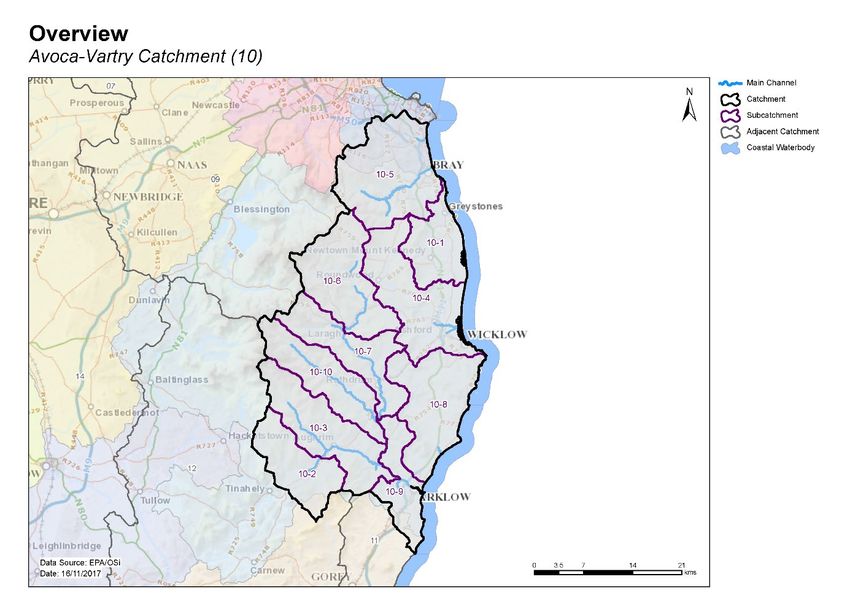
Preface
This document provides a summary of the characterisation outcomes for the water resources of the
Avoca Vartry Catchment, which have been compiled and assessed by the EPA, with the assistance of
local authorities and RPS consultants. The information presented includes status and risk categories of
all water bodies, details on protected areas, significant issues, significant pressures, load reduction
assessments, recommendations on future investigative assessments, areas for actions and
environmental objectives. The characterisation assessments are based on information available to the
end of 2015. Additional, more detailed characterisation information is available to public bodies on the
EPA WFD Application via the EDEN portal, and more widely on the catchments.ie website. The purpose
of this document is to provide an overview of the situation in the catchment and help inform further
action and analysis of appropriate measures and management strategies.
This document is supported by, and can be read in conjunction with, a series of other documents which
provide explanations of the elements it contains:

    1. An explanatory document setting out the full characterisation process, including water body,
       subcatchment and catchment characterisation.
    2. The Final River Basin Management Plan, which can be accessed on: www.catchments.ie.
    3. A published paper on Source Load Apportionment Modelling, which can be accessed at:
       http://www.jstor.org/stable/10.3318/bioe.2016.22
    4. A published paper on the role of pathways in transferring nutrients to streams and the relevance
       to water quality management strategies, which can be accessed at:
       http://www.jstor.org/stable/pdf/10.3318/bioe.2016.19.pdf
    5. An     article   on    Investigative   Assessments       which     can     be    accessed     at:
       https://www.catchments.ie/download/catchments-newsletter-sharing-science-stories-june-
       2016/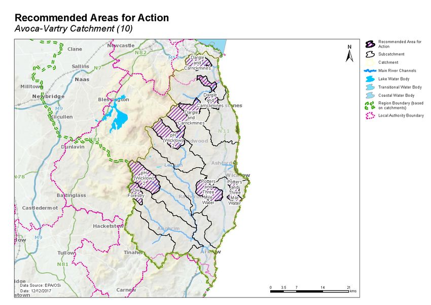
Table of contents
1     Introduction .......................................................................................................................... 1
2     Water body status and risk of not meeting environmental objectives ............................... 2
    2.1     Surface water ecological status ..................................................................................... 2
      2.1.1        Rivers and lakes ..................................................................................................................2
      2.1.2        Transitional and Coastal (TraC) .......................................................................................... 2
    2.2     Groundwater status....................................................................................................... 6
    2.3     Risk of not meeting surface water environmental objectives ...................................... 7
      2.3.1        Rivers and lakes ..................................................................................................................7
      2.3.2        Transitional and Coastal (TraC) .......................................................................................... 7
    2.4     Risk of not meeting groundwater environmental objectives ....................................... 8
    2.5     Protected areas ............................................................................................................. 9
      2.5.1        Drinking water abstractions ............................................................................................... 9
      2.5.2        Bathing waters ...................................................................................................................9
      2.5.3        Shellfish areas ..................................................................................................................10
      2.5.4        Nutrient Sensitive Areas ..................................................................................................10
      2.5.5        Natura 2000 Sites .............................................................................................................10
    2.6     Heavily modified water bodies .................................................................................... 10
3     Significant issues in At Risk water bodies .......................................................................... 11
4     Significant pressures........................................................................................................... 11
    4.1     Water bodies ............................................................................................................... 11
      4.1.1        Rivers lakes, transitional and coastal (TraC) ....................................................................11
      4.1.2        Groundwater ....................................................................................................................11
    4.2     Pressure type ............................................................................................................... 12
      4.2.1        Urban waste water treatment plants ..............................................................................12
      4.2.2        Forestry ............................................................................................................................12
      4.2.3        Agriculture ........................................................................................................................15
      4.2.4        Other ................................................................................................................................15
      4.2.5        Diffuse urban ....................................................................................................................18
      4.2.6        Hydromorphology ............................................................................................................18
      4.2.7        Domestic waste water .....................................................................................................18
      4.2.8        Industry ............................................................................................................................21
      4.2.9        Extractive industry ...........................................................................................................21

5     Load reduction assessment ................................................................................................ 22
    5.1     River water body load reductions ............................................................................... 22
    5.2     TraC load reductions.................................................................................................... 23
6     Further Characterisation and Investigative Assessments.................................................. 24
7     Catchment summary .......................................................................................................... 24
8     Areas for Action .................................................................................................................. 25
8.1     Process of Selection ..................................................................................................... 25
    8.2     Outcomes of process ................................................................................................... 25
9     Environmental Objectives .................................................................................................. 30
    9.1     Surface Water .............................................................................................................. 30
    9.2     Groundwater ............................................................................................................... 30
10 Acknowledgements ............................................................................................................ 31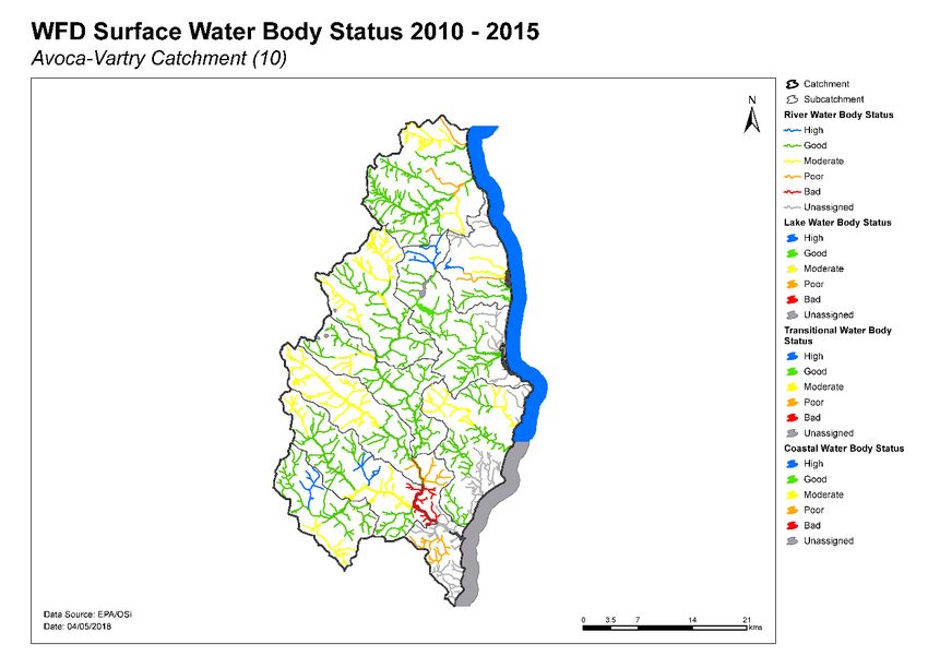
1   Introduction
This catchment includes the area drained by the Rivers Avoca and Vartry and by all streams entering
tidal water between Sorrento Point, Co. Dublin and Kilmichael Point, Co. Wexford, draining a total area
of 1,247km². The largest urban centre in the catchment is Bray. The other main urban centres in this
catchment are Dun Laoghaire-Rathdown, Arklow, Wicklow Town, Rathnew, Newtown Mount Kennedy,
Greystones, Delgany and Kilcoole. The total population of the catchment is approximately 179,100 with
a population density of 144 people per km². The higher areas of the Wicklow Mountains are underlain
by granite bedrock while metamorphic slates and quartzites underlie the eastern coastal part of the
catchment.

The Shanganagh River drains the eastern slopes of the Dublin Mountains, flowing east through South
Dublin and into the sea at Killiney Bay. The River Dargle rises on the northern side of Djouce Mountain,
flowing east, over Powerscourt Waterfall and meets the Glencree River from the west. It then then
continues east, before being joined by the Glencullen River and flowing into the sea at Bray Harbour.

The Vartry River rises on the eastern slopes of Djouce Mountain, flowing south and through the Upper
and Lower Vartry Reservoirs. The river then enters the steep-sided Devil’s Glen, through the eastern
Wicklow Hills and into the northern end of Broad Lough, from where it flows into the sea via Wicklow
Harbour. The hilly coastal area of Wicklow between Wicklow town and Arklow is drained by a series of
south easterly flowing rivers including the Three Mile water, Potter’s and Redcross Rivers.

The Avoca River system drains most of the Wicklow Mountain area. The Avonmore River rises to the
south of the Sally Gap, flowing through Lough Tay and then Lough Dan, continuing south where it is met
at Laragh by the Glenmacnass, Glendasan and Glenealo Rivers. The Turlough Hill pumped storage
hydroelectric generating station is situated on the headwaters of the Glendassan River. The Avonmore
continues south through Rathdrum to the Meeting of the Waters where the Avonbeg River joins. Now
called the Avoca River, it continues past its namesake town to Woodenbridge where the Aughrim River
flows in. This tributary is the combined outflow from the Ow River and the Darry Water. Downstream
of Woodenbridge, the Avoca River flows through a flat-floored, steeply-sided valley before becoming
tidal just upstream of Arklow Town, through which it flows before it makes it way to the sea via Arklow
Harbour.

The Avoca Vartry catchment comprises 10 subcatchments with 71 river water bodies, 11 lakes, four
transitional and three coastal water bodies, and 10 groundwater bodies (Table 1, Figure1).

Table 1. List of subcatchments in the Avoca Vartry catchment
          Subcatchment ID                                Subcatchment Name
 10_1                                 Newcastle [Wicklow]_SC_010
 10_2                                 DerryWater_SC_010
 10_3                                 Avoca_SC_010
 10_4                                 Vartry_SC_010
 10_5                                 Dargle_SC_010
 10_6                                 Avonmore_SC_010
 10_7                                 Avonmore_SC_020
 10_8                                 Redcross_SC_010
 10_9                                 Avoca_SC_020
 10_10                                Avonbeg_SC_010

                                                   1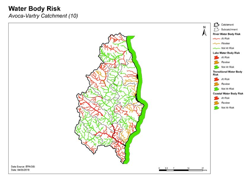
Figure 1. Subcatchments in the Avoca Vartry catchment

2   Water body status and risk of not meeting environmental objectives
2.1 Surface water ecological status
2.1.1   Rivers and lakes
♦ There were 41 (50%) river and lake water bodies at Good or High status, and 26 (32%) at less than
  Good status in 2015 (Table 2, Figure 2). Fifteen (18%) river and lakes water bodies are unassigned.
♦ Seven river water bodies and sites have a high ecological status objective. In 2015, three of these
  water bodies were at High status (Askanagap Stream_010, Ballycreen Brook_010 and Varty_010),
  three were at Good (Dargle_010, Glencullen_010 and Avonmore_020), and one (Avonmore_010)
  was at Moderate status (Figure 3, Appendix 1).
♦ The numbers of water bodies at each status class in 2007-09 and 2010-15 are shown in Figures 4
  (rivers) and 5 (lakes).
♦ Fifteen water bodies have improved and 11 have deteriorated since 2007-09 (Figure 6a).
♦ The variations in nutrient concentrations and loads in the Avonmore and Avoca main channels are
  illustrated in Appendix 2.

2.1.2   Transitional and Coastal (TraC)
♦ Of the seven TraC water bodies, one was at High status (Southwestern Irish Sea - Killiney Bay
  (HA10)), one was at Good (Southwestern Irish Sea (HAs 11;12)) 29 % and two were at Moderate
  status (Broad Lough and Avoca Estuary) 29% in 2015 (Table 2, Figure 2). Three TraC water bodies
  42% were unassigned.

                                                 2
♦ One TraC water body has a high ecological status objective, Southwestern Irish Sea - Killiney Bay
(HA10), and this was at High status in 2015.
♦ The numbers of TraC water bodies in each status class in 2007-09 and 2010-15 is shown in Figure
6.
♦ Note the TraC water bodies Southwestern Irish Sea (HAs 11;12), Southwestern Irish Sea - Killiney
Bay (HA10) and Southwestern Irish Sea - Brittas Bay (HA 10) are shared with other catchments.
Table 2. Summary of surface water body status and risk categories
Number 2010-15 Status Risk Categories
of water Not at At
bodies High Good Mod Poor Bad Unassigned Review
Risk Risk
Rivers 71 4 35 17 5 1 9 34 9 28
Lakes 11 0 2 3 0 0 6 4 6 1
TraC 7 1 1 2 0 0 3 3 2 2
Figure 2. Surface water ecological status
3Figure 3. High ecological status objective water bodies and sites
River status over the WFD cycles
40
35
No. of Water Bodies
30
25
20
Good
15
Unassigned
Unassigned
Good
Moderate
Moderate
10
Poor
Poor
High
High
5
Bad
Bad
0
07-09 10-15
WFD Cycles and Status
Figure 4. Number of rivers at each status class in 2007-09 and 2010-15
4Lake status over the WFD cycles
7
6
No. of Water Bodies
5
4
Unassigned
Unassigned
3
Moderate
2 Moderate
Good
Good
1
0
07-09 10-15
WFD Cycles and Status
Figure 5. Number of lakes at each status class in 2007-09 and 2010-15
Transitional water body status over the WFD cycles
4
No. of Water Bodies
3
2
Unassigned
Unassigned
Moderate
Moderate
1
Good
Good
High
High
0
07-09 10-15
WFD Cycles and Status
Figure 6. Number of transitional and coastal water bodies at each status class in
2007-09 and 2010-15
5Figure 6a. Surface water body status changes from 2007-09 to 2010-15
2.2 Groundwater status
♦ Six groundwater bodies were at Good status in 2015, and four were at Poor status (Table 3, Figures
6b and 7).
Table 3. Summary of groundwater body status and risk categories
2010-15 Status Risk Categories
Number of
water bodies Good Poor Not at Risk Review At Risk
Groundwater 10 6 4 1 5 4
Groundwater Status over the WFD cycles
10
No. of Water
8
Bodies
6
Good
4
Good
Poor
Poor
2
0
07-12 10-15
Monitoring Cycles and Status
Figure 6b - Number of groundwater bodies at each status class in 2007-09 and 2010-15
6Figure 7. Groundwater body status
2.3 Risk of not meeting surface water environmental objectives
2.3.1 Rivers and lakes
♦ There are 34 river water bodies and four lake water bodies Not at Risk (Figure 8, Table 2) which
require no additional investigative assessment or measures to be applied, other than those
measures that are already in place.
♦ There are nine river water bodies and six lake water bodies in Review. This includes 10 water bodies
where more information is required and 5 water bodies where measures have recently been
implemented and improvements have not yet been realised.
♦ Twenty-eight river water bodies and one lake water body Upper Glendalough in the catchment are
At Risk of not meeting their water quality objectives. Measures will be needed in these water bodies
to improve the water quality outcomes. Summary information for the At Risk water bodies is given
in Appendix 3.
2.3.2 Transitional and Coastal (TraC)
♦ Three coastal water bodies are Not at Risk – Southwestern Irish Sea - Killiney Bay (HA10),
Southwestern Irish Sea (HAs 11;12) and Southwestern Irish Sea - Brittas Bay (HA 10) (Figure 8, Table
2) and require no additional investigative assessment or measures to be applied, other than those
measures that are already in place.
♦ Two transitional water bodies, Dargle Estuary and Kilcoole Marsh are in Review.
♦ Two transitional water bodies, Broad Lough and Avoca Estuary are At Risk of not meeting their water
quality objectives. Measures will be needed in these water bodies to improve the water quality
outcomes.
7Figure 8. Surface water body risk
2.4 Risk of not meeting groundwater environmental objectives
♦ One groundwater body (Kilcullen) is Not at Risk (Figure 9, Table 3) and requires no additional
investigative assessment or measures to be applied, other than those measures that are already in
place.
♦ Five groundwater bodies (Kilcoole Gravels, Enniskerry Gravels, Wicklow, GWDTE-Buckroney-Brittas
Fen (SAC000729) and GWDTE-Buckroney-Brittas Dunes (SAC000729)) are in Review (Figure 9).
Enniskerry Gravels, Kilcoole Gravels and Wicklow are all in Review due to elevated nitrate
concentrations. The issues in GWDTE-Buckroney-Brittas Fen (SAC000729) are related to water
quantity/levels and excess nutrients, while in GWDTE-Buckroney-Brittas Dunes (SAC000729) it is
also water quantity/levels.
♦ Four groundwater bodies are At Risk, Historic Mine (Glendalough), Historic Mine (Glenmalure),
Historic Mine (Avoca) and Industrial Facility (P0019-02). Measures will be needed in these water
bodies to improve the water quality outcomes. For the mine sites the issues are the elevated
concentrations of heavy metals due to acid mine drainage from lead-zinc mines. The impact from
the industrial site is due to trichloroethylene (TCE).
8Figure 9. Groundwater body risk
2.5 Protected areas
2.5.1 Drinking water abstractions
♦ There are 42 abstractions in the Avoca Vartry Catchment comprising one regional supply (Wicklow
Regional Supply), 25 public supplies and six private water supplies (Appendix 4).
♦ Twenty-nine of the abstractions are from two groundwater bodies Dunes (SAC000729) and the
remaining 13 are from 11 river water bodies. The list of the public supplies and the associated water
bodies is provided in Appendix 4.
♦ All sources were compliant with the standard for nitrate in 2015.
♦ All sources were compliant with the standard for pesticides in 2015. (Note that the Wicklow
Regional Supply was non-compliant (MCPA, picloram) in 2014).
2.5.2 Bathing waters
♦ There are seven designated marine bathing waters in the catchment. All seven are in satisfactory
condition.
♦ The list of the bathing waters and the associated water bodies is provided in Table 4.
9Table 4. Designated bathing waters in the catchment
Bathing water Water body intersection Objective met?
Name Code Name Code Yes No
Southwestern Irish Sea –
Killiney IEEABWC100_0000_0400 IE_EA_100_0000
Killiney Bay (HA 10)
Southwestern Irish Sea –
Bray South Promenade IEEABWC100_0000_0300 IE_EA_100_0000
Killiney Bay (HA 10)
Southwestern Irish Sea –
Greystones South IEEABWC100_0000_0200 IE_EA_100_0000
Killiney Bay (HA 10)
Southwestern Irish Sea –
Silver Strand IEEABWC100_0000_0100 IE_EA_100_0000
Killiney Bay (HA 10)
Southwestern Irish Sea –
Brittas Bay North IEEABWC140_0000_0300 IE_EA_140_0000
Brittas Bay (HA 10)
Southwestern Irish Sea –
Brittas Bay South IEEABWC140_0000_0200 IE_EA_140_0000
Brittas Bay (HA 10)
Southwestern Irish Sea –
Clogga IEEABWC140_0000_0100 IE_EA_140_0000
Brittas Bay (HA 10)
2.5.3 Shellfish areas
♦ There are no designated shellfish areas in the catchment.
2.5.4 Nutrient Sensitive Areas
♦ There are no designated Nutrient Sensitive Areas (NSAs) in the catchment.
2.5.5 Natura 2000 Sites
♦ There are 12 Special Areas of Conservation (SACs) in the catchment (Appendix 5), not all of which
have water quality and/or quantity conservation objectives for their qualifying interests.
♦ Three lake water bodies (Upper Glendalough, Tay and Dan) have been prioritised for action as the
water conservation objectives for their habitats and/or species are not being supported by
ecological status (Appendix 5).
♦ There are three Special Protected Areas (SPAs) in the catchment:
o The Murrough SPA
o Wicklow Head SPA
o Wicklow Mountains SPA
As there are no specific water quality and quantity supporting conditions identified in the site-
specific conservation objectives for these SPAs, the intersecting water bodies are not assigned for
priority action for WFD protected area purposes in the second cycle.
♦ There are six river water bodies that are designated as salmonid rivers (under Salmonid Regulations
(S.I. 293 / 1988)) that are not located within SACs. One of these water bodies (Dargle_030) has been
prioritised for action as the water conservation objectives for this species are not being supported
by ecological status (Appendix 5).
2.6 Heavily modified water bodies
♦ There are four designated heavily modified water bodies (HMWB) in the catchment: Vartry_020,
Vartry Lower and Vartry Upper due to the presence of a drinking water abstraction; and Nahanagan
due to power generation. Vartry_020 and Vartry Lower were classified as having Good Ecological
Potential in 2013-15, while Vartry Upper and Nahanagan were unassigned.
♦ There are no artificially modified water bodies (AWBs) in the catchment.
103 Significant issues in At Risk water bodies
♦ Excess phosphorus leading to eutrophication is the dominant issue in the At Risk water bodies.
♦ Alteration of hydromorphological (or physical) conditions are a significant issue, including the input
of excessive fine sediment. Such impacts have altered the morphology of water bodies and, in turn,
have altered the habitat conditions.
♦ Broad Lough is being impacted by excess nutrients from agriculture, and suspected impacts from
waste water (Wicklow). Avoca Estuary is impacted by elevated heavy metals from the historic Avoca
Mines site and waste water from the Arklow agglomeration.
♦ There are four At Risk groundwater bodies; three are At Risk due to elevated heavy metal
concentrations (historic mines) and one is due to trichloroethylene (TCE) from an industrial site.
4 Significant pressures
4.1 Water bodies
♦ Where water bodies have been classed as At Risk, significant pressures have been identified.
♦ Figure 10 shows a breakdown of the number of At Risk water bodies in each significant pressure
category.
4.1.1 Rivers lakes, transitional and coastal (TraC)
♦ Significant pressures have been identified, through the initial characterisation process, in 31 surface
water bodies, 15 of which have multiple pressures. The significant pressures will be refined as
further characterisation is carried out.
♦ The significant pressures affecting the greatest number of water bodies are a miscellaneous group
termed ‘Other’ in Figure 10 which includes historic mines, golf courses, aquaculture, atmospheric,
tourism and illegal dumping. These pressures are typically relatively uncommon nationally which is
why they are grouped. The next most common pressure is urban waste water, followed by forestry,
agriculture, diffuse urban, hydromorphological pressures, domestic waste water, mines and
quarries, and industry.
♦ There is only one lake that is At Risk (Upper Glendalough), with forestry and tourism currently noted
as significant pressures.
♦ Agriculture has been identified as the significant pressure impacting Broad Lough, with likely urban
waste water impacts from Wicklow town. For Avoca Estuary, heavy metals from the Avoca Mines
and waste water from Arklow are the significant pressures.
4.1.2 Groundwater
There are four At Risk groundwater bodies – Historic Mine (Glendalough), Historic Mine (Glenmalure),
Historic Mine (Avoca) and Industrial Facility (P0019-02). For the mine sites, the pressure is acid mine
drainage as a result of historic mining activities. The pressure from the industrial site is due to
trichloroethylene (TCE).
11Significant pressures in At Risk water bodies
14
12
10
No. of water bodies
8
Groundwater
6
Transitional
Lake
4 Rivers
2
0
Figure 10. Significant pressures impacting on At Risk bodies
4.2 Pressure type
4.2.1 Urban waste water treatment plants
♦ Urban Waste Water Treatment Plants (WWTPs) and agglomeration networks have been highlighted
as a significant pressure in 11 At Risk water bodies; details are given in Table 5 and Figure 15. Five
of these At Risk water bodies are impacted by WWTPs and agglomeration networks that are
scheduled to be upgraded, including two water bodies, Kilcoole Stream_010 and Aughrim
(Wicklow)_020, which are impacted by WWTPs that were due to be upgraded in 2017.
4.2.2 Forestry
♦ Forestry has been identified as a significant pressure in nine river water bodies and one lake (Upper
Glendalough) (Figure 16, Appendix 3). The significant issue affecting the greatest number of water
bodies is acidification (includes Upper Glendalough). Increased siltation, often linked to clearfelling
and associated activities such as road construction, is also significant.
12Figure 15. Water bodies that are At Risk and are impacted by urban waste water
Figure 16. Water bodies that are At Risk and are impacted by forestry
13Table 5. Waste Water Treatment Plants and agglomerations identified as Significant Pressures in At Risk
water bodies and expected completion dates for associated upgrade works, where applicable.
Expected
2010-15 Completion Date
Facility name Facility Type Water Body Ecological Status
Kilcoole 2,001 to 10,000
D0087 p.e. Kilcoole Stream_010 Moderate 2017
Kilcoole 2,001 to 10,000
D0087 p.e. Newtownmountkennedy_020 1 Poor NA 2
Kilpedder
D0416 500 to 1,000 p.e. Kilcoole Stream_010 Moderate Complete
Kirikee Lower
A0039 < 500 p.e. Avonbeg_030 Moderate NA 2
Kirikee Upper
A0045 < 500 p.e. Avonbeg_030 Moderate NA 2
Aughrim 1,001 to 2,000
D0222 p.e. Aughrim (Wicklow)_020 Moderate 2017
Shanganagh-Bray
D0038 > 10,000 p.e. Kill of the Grange Stream_010 1 Poor 2018
Bray
D0005 > 10,000 p.e. Kilmacanoge_010 Moderate NA 2
Thomastown
A0030 < 500 p.e. Ballyduff Stream (Wicklow)_010 Poor NA 2
Avoca
D0411 500 to 1,000 p.e. Avoca_030 Unassigned 3 2025
Avoca
D0411 500 to 1,000 p.e. Avoca_020 Bad 2025
Arklow Ballyduff Stream (Wicklow)_010
4
D0006 > 10,000 p.e. Poor 2022
Enniskerry 2,001 to 10,000
D0088 p.e. Dargle_030 Poor 2018
Wicklow
D0012 > 10,000 p.e. Broad Lough 1 Moderate NA 2
1
The agglomeration network, rather than the WWTP, has been identified as a significant pressure impacting
Newtownmountkennedy_020, Broad Lough and Kill of the Grange Stream_010.
2 Currently not specified in improvement plans. The Kilpedder WWTP was upgraded in 2017, however, the agglomeration
network, which been identified as a significant pressure impacting Newtownmountkekkedy_020, is currently not specified in
improvements.
3 Ecological Status is not available for Avoca_030, however, following discussions with Wicklow County Council, this water body
was deemed to be At Risk of not meeting its environmental objectives.
4
Ballyduff Stream (Wicklow)_010 is impacted by both the Arklow WWTP and the agglomeration network.
144.2.3 Agriculture
♦ Agriculture is a significant pressure in six river water bodies and one transitional water body, Broad
Lough (Figure 17, Appendix 3). The issues related to farming in this catchment are varied, including
diffuse loss of phosphorus and ammonia to surface waters from, for example, direct discharges; or
runoff from yards, roadways or other compacted surfaces, or runoff from poorly draining soils.
Sediment can also be a problem from land drainage works, bank erosion from animal access or
stream crossings. The pollution impact potential map showing areas of relative risk for phosphorus
loss from agriculture to surface water is given in Appendix 6.
Figure 17. Water bodies that are At Risk and are impacted by agricultural activities
4.2.4 Other
♦ Historic mines have been identified as a significant pressure in four river water bodies –
Glenealo_020, Avoca_010, Avoca_020 and Avoca_030. One transitional water body Avoca Estuary
is also impacted by historic mines (Figure 11, Appendix 3), and three groundwater bodies (Historic
Mine (Glendalough), Historic Mine (Glenmalure) and Historic Mine (Avoca)). The significant
pressure arises because of the historic mines at Avoca which are discharging acid mine drainage.
This gives rise to increased concentrations of heavy metals (above the Environmental Quality
Standard).
15Figure 12. Surface water bodies that are At Risk and are impacted by other anthropogenic pressures.
Note that groundwater bodies are indicated on Figure 9.
Figure 11. Water bodies that are At Risk and are impacted by historic mines. Note that groundwater
bodies are indicated on Figure 9.
♦ Tourism has been identified as a significant pressure in one lake water body Upper Glendalough
(Figure 12). The pressures are somewhat unclear but may relate to hiking, trekking and associated
16activities in the Glendalough area causing erosion and excess sediment. These have also been
identified in Lower Glendalough.
♦ A golf course has been identified as a significant pressure in one river Avonbeg_030 (Figure 12). The
issues relate to elevated nutrients.
♦ Aquaculture has been identified as a significant pressure in one river Aughrim (Wicklow)_020 (Figure
13). There are three Section 4 discharges from fish farms on this river, causing elevated ammonia
concentrations.
♦ Illegal dumping has been identified as a significant pressure in one river water, Three Mile
Water_020 (Figure 14).
♦ Low pH is causing the downgrade to Moderate Ecological Status in one river water body
Avonmore_010 but the significant pressure is unknown.
Figure 13. Water bodies that are At Risk and are impacted by aquaculture
17Figure 14. Water bodies that are At Risk and are impacted by waste related activity
4.2.5 Diffuse urban
♦ Diffuse urban pressures, caused by misconnections, leaking sewers and runoff from paved and
unpaved areas, have been identified as a significant pressure in four river water bodies (Aughrim
(Wicklow)_010, Kill of the Grange Stream_010, Kilmacanoge_010 and Carrickmines Stream_010).
In the case of Aughrim (Wicklow)_010, it is likely there is a diffuse urban pressure from Aughrim
town. Kill of the Grange stream is primarily impacted by misconnections and SWOs from both
Sandyford and Deansgrange. The diffuse pressure on Kilmacanogue_010 has been identified as the
dual carriageway which passes through. Finally, Carrickmines is the source of the diffuse urban
pressure on the Carrickmines Stream_010 (Figure 18, Appendix 3).
4.2.6 Hydromorphology
♦ One river water body within the Dargle (10_5) and one river water body within the Redcross (10_8)
subcatchments are subject to extensive modification due to the presence of flood alleviation works
and road works, respectively. In addition, one river water body within the Dargle (10_5) is mostly
culverted leading to modified physical aquatic habitat. Excessive levels of siltation exist within one
river water body of the same subcatchment due to bank erosion. This issue will need to be reviewed.
Water bodies that are At Risk and impacted by hydromorphological pressures are shown in Figure
19 and listed in Appendix 3.
4.2.7 Domestic waste water
♦ Domestic waste water has been identified as a significant pressure in two river water bodies,
Ballyronan Stream_010 and Potter’s_010. In the case of Ballyronan Stream_010, there is a discharge
from a private development (600p.e.) which has caused an impact due to a lack of assimilative
capacity within the stream. In Potter’s_010, the pressure is adjudged to be the cumulative effect of
18many smaller sewage discharges resulting in enrichment and organic contamination (Figure 20,
Appendix 3).
Figure 18. Water bodies that are At Risk and are impacted by diffuse urban pressures
19Figure 19. Water bodies that are At Risk and are impacted by hydromorphological pressures
Figure 20. Water bodies that are At Risk and are impacted by domestic waste water
204.2.8 Industry
♦ An industrial site has been identified as a significant pressure impacting Ballyronan Stream_010,
with elevated orthophosphate concentrations being the main issue of concern. Another site which
has legacy issues related to total ammonia concentrations in groundwater, has been identified as
a significant pressure impacting Avoca_030 (Figure 21). Industry also impacts on the groundwater
body around the Industrial Facility (P0019-02).
4.2.9 Extractive industry
♦ Quarries
Quarries have been identified as a significant pressure in two water bodies – Potter’s_010 and Three
Mile Water_020 (Figure 22, Appendix 3). For Potter’s_010, heavy siltation associated with a large
quarry upstream in Ballinclare is a significant pressure, with heavy siltation noted in the 2015 survey.
For Three Mile Water_020, the Eastern River Basin District Mobile Monitoring Unit identified two
quarries upstream that may be causing a silt/sediment issue. Heavy siltation was also noted by EPA
biologists here in 2015.
Figure 21. Water bodies that are At Risk and are impacted by industry
21Figure 22. Water bodies that are At Risk and are impacted by extractive industries 5 Load reduction assessment 5.1 River water body load reductions ♦ Phosphate is the main parameter influencing water quality in rivers in the catchment. ♦ For water bodies where phosphorus monitoring data are available, the reduction in P load that would be required to bring the mean concentration back to the EQS of 0.035 mg/l as P, can be estimated using a simple method based on the average 2013 to 2015 concentration and the average flow, or the estimated 30th percentile flow (Q30) where flow data are not available. The relative load reductions are ranked on a national scale from Very High (>1 kg/Ha/y), to High (0.5-1 kg/Ha/y), to Medium (0.25-0.5 kg/Ha/y) to Low (
5.2 TraC load reductions
Some 18 estuaries in Ireland have been monitored on a continual basis since 1990 as part of Ireland’s
commitment under the Convention for the Protection of the Marine Environment of the North-East
Atlantic (the Ospar Convention). This has shown that generally over the long term, nutrients have
decreased but further reduction will be required in many cases to support Good Ecological Status.
However, many estuaries have not been monitored to the same degree, and where monitoring data in
insufficient, an ongoing programme of modelling is being undertaken to estimate potential nutrient load
removal required from contributing sub-catchments.

Different estuaries may require reductions in different nutrients. Further modelling work is required to
determine precisely what load reductions are required, but in the interim, further monitoring will be
carried out to assess the improvements resulting from various planned measures, and to confirm the
nature of the issues.

In the Avoca-Varty catchment:

♦ As part of the Irelands commitment to the Ospar Convention, nutrient flux or load monitoring has
  been carried out on the Avoca Estuary since 1990 (Figure 22a and 22b). Total N dropped sharply in
  1995 following improvements at a large industrial facility, while P increased in the mid-90’s, before
  declining to 1/3 of the load measured in 1990. Further analysis of these nutrient load trends is
  available at http://dx.doi.org/10.3318/BIOE.2016.23.
♦ The required nutrient load reduction for the Avoca estuary is unknown. However, achieving Good
  status in this water body is dependent on achieving a reduction in heavy metal concentrations from
  the historic mine.
♦ The nutrient load reduction required for the Broad Lough is unknown. There are currently no data
  for two of the three inflowing streams and there has been no estuarine modelling carried out.

                                        Total N (Avoca)
           25000

           20000
  Tonnes

           15000

           10000

           5000

              0
                   1990 1992 1994 1996 1998 2000 2002 2004 2006 2008 2010 2012 2014
Figure 22a – Total Nitrogen Load (tonnes/year) 1990 to 2015

                                                  23
Total P (Avoca)
90
80
70
60
Tonnes
50
40
30
20
10
0
1990 1992 1994 1996 1998 2000 2002 2004 2006 2008 2010 2012 2014
Figure 22b – Total Phosphorus Load (Tonnes/year) 1990-2015
6 Further Characterisation and Local Catchment Assessments
♦ Further characterisation through local catchment assessments is needed in 29 of the At Risk river
and lake water bodies to refine the understanding of the significant pressures at the site/field scale
so that specific and targeted measures can be identified.
♦ Further characterisation through local catchment assessments is needed in 15 Review river and lake
water bodies to refine the understanding of the issues if any, and the significant pressures where
relevant, at the site/field scale so that specific and targeted measures can be identified.
♦ Brief definitions on the 10 IA assessment scenarios are given in Appendix 7 and the number of IAs
required for each scenario are given in Table 7.
Table 7. Investigative assessment allocation for At Risk and Review river and lake water bodies
Risk IA 1 IA 2 IA 3 IA 4 IA 5 IA 6 IA 7 IA 8 IA 9 IA 10 Total
At 30 1 3 1 2 4 7 4 0 0 52
Risk
Revie 5 0 8 0 0 1 1 0 0 0 15
w
Note water bodies may have multiple categories of Local Catchment Assessments
7 Catchment summary
♦ Of the 71 river water bodies, 28 are At Risk of not meeting their WFD objectives.
♦ Out of the 11 lake water bodies, only one is At Risk of not meeting their WFD objectives.
♦ There are two of the TraCs water bodies, Broad Lough and Avoca Estuary are At Risk of not meeting
their WFD objectives. The Avoca Estuary is At Risk and is impacted by heavy metal and waste water
from Arklow agglomeration. Agriculture is the significant pressure on Broad Lough as well as
suspected waste water discharges from Wicklow.
♦ Excess nutrient loss, mainly phosphate, leading to eutrophication is also a major issue for rivers and
lakes in the catchment. The significant pressures relating to excess nutrients are primarily waste
24water (urban and domestic), but also related to agriculture, forestry activity and diffuse urban
pressures for the most part. Elevated ammonia from aquaculture is also a pressure.
♦ Hydromorphological (or physical) conditions (including the input of excessive fine sediment) and
poor habitat quality are issues for several surface water bodies.
♦ There are four groundwater bodies At Risk, Historic Mine (Glendalough), Historic Mine
(Glenmalure), Historic Mine (Avoca) and Industrial Facility (P0019-02). For the mine sites the
pressure relates to the elevated concentrations of heavy metals due to acid mine drainage from
lead-zinc mines. The pressure from the industrial site is due to trichloroethylene (TCE).
8 Areas for Action
The characterisation outcomes described above have highlighted that there is significant work to do in
the catchment to protect and restore water quality, and meet the objectives of the WFD. During the
development of the draft river basin management plan it became apparent that there would be a need
to prioritise areas for collective action so that the best return on investment could be achieved. 190
Areas for action have been selected nationally in a process as described below. There are 4 areas for
action in the Avoca/Vartry catchment
8.1 Process of Selection
Following the publication of the draft river basin management plan in early 2017, the EPA and the Local
Authority Waters and Communities Office (LAWCO) jointly led a collaborative regional workshop
process to determine where, from a technical and scientific perspective, actions should be prioritised in
the second cycle. The prioritisation process was based on the priorities in the draft river basin
management plan, the evidence from the characterisation process, and the expertise, data and
knowledge of public body staff with responsibilities for water and the different pressure types. The
recommended areas for action selected during the workshops were then agreed by the Water and
Environmental Regional Committees. Since this selection, the Local Authorities Water and Communities
Office (LAWCO) have undertaken public engagement and feedback sessions in each local authority.
The recommended areas for action are an initial list of areas where action will be carried out in the
second cycle. All water bodies that are At Risk still however, need to be addressed. As issues are
resolved, or when feedback from the public engagement process is assessed, areas for action may be
removed from the list and new areas will be added. If additional monitoring shows that new issues have
arisen, new areas may become a priority and may need to be added to the work programme.
The initial list of areas for action is not therefore considered as a closed or finite list; it simply represents
the initial areas where work will be carried out during the second WFD planning cycle from 2018 to
2021.
8.2 Outcomes of process
The outcomes for the Avoca Vartry catchment are summarised below.
♦ Four recommended areas for actions (Table 89, Figure 23) were selected.
♦ These are the Ow Forestry, Potters and Three Mile Water, Dargle and Carrickmines, pH
(Wicklow) 2.
♦ These include 11 At Risk river water bodies.
♦ There are no At Risk or Review water bodies where risk is driven by groundwater contribution
of nutrients to surface water.
25A remaining 37 At Risk and Review surface water bodies were not included in the recommended areas
for action for the second cycle. The distribution of these is presented in Figure 23. These include:
♦ 33 river and lake water bodies – 18 At Risk and 15 Review, and
♦ four transitional and coastal water bodies – two At Risk and two Review.
Table 8. Recommended Areas for Action in the Avoca Vartry catchment
Number
Recommended Local
of water SCs Reason for Selection
area for action authority
bodies
• High Ecological Status ecological objective water
body requiring improvement.
Ow Forestry 1 10_3 Wicklow • Building on work that is underway by Coillte.
• Multi agency collaboration between Coillte,
Wicklow County Council and the IFI.
• Building on improvements in Potters_010 –
improved from Poor to Moderate between 2007-
2009 and 2010-2015.
• Building on existing knowledge in Wicklow County
Council regarding farms and quarries in the area.
Potters and • Building on improvements following completion of
Three Mile 2 10_8 Wicklow roadworks that were a pressure.
Water • Good community engagement - there are 3 Group
Water Schemes.
• Discharges into Brittas Bay designated bathing
waters.
• A drinking water abstraction in Potters_010.
• Potential for ‘quick wins’ in both water bodies.
• Multi agency cooperation between DLR, Irish Water,
Inland Fisheries Ireland.
• Building on completed and planned assessments on
the Carrickmines Stream_010.
• Building on Drainage Area Plan completed by Irish
Wicklow
Water on Carrickmines Stream_010.
Dargle and Dun
4 10_5 • Carrickmines Stream_010 is a headwater stream to
Carrickmines Laoghaire
Shanganagh_010, which is at Good status.
Rathdown
Dargle_010 is the headwaters to the River Dargle.
• Dargle_010 has a High Ecological Status objective
and has deteriorated.
• Dargle_030 is a deteriorated water body with
protected area objectives for salmonids.
• 2nd pH project to link to the other Wicklow pH
10_10 project. Four deteriorated water bodies.
pH (Wicklow) 2 4 Wicklow
10_6 • Two High Ecological Status objective water bodies.
Headwaters to the Avonbeg and Avonmore rivers.
26.
27Figure 23. Location of Recommended Areas for Action in the Avoca Vartry Catchment. Note the waterbodies within an Areas for Action are not always
contiguous.
28Figure 24. Location of At Risk and Review water bodies located outside Recommended Areas for Action in the Avoca Vartry Catchment
299 Environmental Objectives
9.1 Surface Water
♦ Assuming resources are available and actions are taken in the recommended areas for action, of
the 11 At Risk surface water bodies, it is predicted that seven (64%) could improve by 2021 and four
(36%) could achieve their objective by 2027, see Table 11.
Table 11: Environmental objective dates for water bodies in the Recommended Areas for Action
Risk Category No. of Water No. of WBs for 2021 No. of WBs for 2027
Bodies Improvement Status Improvement
Rivers
At Risk 11 7 4
Review 0 0 0
Total 11 7 4
♦ Forty-one surface water bodies have met their 2015 environmental objective.
♦ As action is not yet planned to be taken in the remaining 20 At Risk surface water bodies, a 2027
date is applied to 17 (85%) of the water bodies and a Less Stringent Objective classification is applied
to the remaining 3 (15%). These are because of the long-term legacy issues with historic acid mine
drainage.
♦ For the 17 Review surface water bodies, the absence of information on these water bodies means
that there is no scientific basis to quantify an environmental objective date and therefore a 2027
date is applied, see Table 12.
Table 12: Environmental objectives dates in the At Risk and Review surface water bodies not included
in Recommended Areas for Action
Risk Category No. of Water No. of WBs for No. of WBs for No. of WBs with
Bodies 2021 Improvement 2027 Status Less Stringent
Improvement Objective
Designation
Rivers
At Risk 17 0 14 3
Review 9 0 9 0
Lakes
At Risk 1 0 1 0
Review 6 0 6 0
TraC
At Risk 2 0 2 0
Review 2 0 2 0
Total 37 0 34 3
9.2 Groundwater
♦ Six of the ten groundwater bodies are currently at Good status and, therefore, have met their
environmental objectives.
♦ The four groundwater bodies that are Poor status have a 2027 environmental objective, except
Avoca which has a Less Stringent Objective designation.
30Table 13 Environmental Objective dates of Poor status groundwater bodies in the Avoca catchment
Water body code Water body name Environmental Objective
IE_EA_G_077 Historic Mine (Glendalough) 2027
IE_EA_G_079 Historic Mine (Glenmalure) 2027
Less Stringent
IE_EA_G_080 Historic Mine (Avoca) Objective
IE_EA_G_091 Industrial Facility (P0019-02) 2027
10 Acknowledgements
This Avoca Vartry Catchment Assessment (Version 2) has been produced by the Catchment Science &
Management Unit, EPA, with the assistance of the following:
• Wicklow County Council
• Dun Laoghaire Rathdown County Council.
• Inland Fisheries Ireland.
• Local Authorities Waters & Communities Office.
• Irish Water.
• RPS Group.
• Ecological Monitoring & Assessment Unit, EPA.
• Hydrometric & Groundwater Section, EPA.
• Informatics Section, EPA.
• Laboratories, EPA.
• Office of Environmental Enforcement, EPA.
• Department of Housing, Planning and Local Government.
• DAFM Forest Service.
• DAFM Agriculture.
• Bord Na Mona.
• Coillte.
• Teagasc.
• Geological Survey Ireland.
• National Federation of Group Water Schemes.
• National Parks and Wildlife Service.
• National Water Forum.
31Appendix 1 High ecological status objective water bodies and sites
Water body/Site Type Codes 2015 Status
Askanagap Stream_010 River IE_EA_10A060400 High
Ballycreen Brook_010 River IE_EA_10B020400 High
Varty_010 River IE_EA_10V010050 High
Dargle_010 River IE_EA_10D010010 Good
Glencullen_010 River IE_EA_10G020300 Good
Avonmore_020 River IE_EA_10A050020 Good
Avonmore_010 River IE_EA_10A050010 Moderate
Southwestern Irish Sea - Killiney Bay (HA10) TraC IE_EA_100_0000 High
32Appendix 2 Catchment scale nutrient concentrations and in-stream loads
The results of the instream water quality assessment for the Avonmore and Avoca subcatchment are
illustrated in Chart 1. This shows the 2015 baseline orthophosphate concentrations along the both main
channels are relatively low and remains constant between 0.006mg/l up to 0.009mg/l.
The ammonia concentrations in the Avonmore Channel are relatively low (between 0.009 and
0.021mg/l) but increases downstream of Avoca_010 after which it becomes elevated above the EQS for
good status (0.065mg/l) at Avoca_030 (0.089mg/l). The subcatchment assessment notes the impact
from the discharge of raw sewage but does not state the source. The Avoca_030 discharges into the
Avoca Estuary. The secondary discharges from the Arklow WWTP are all attributed to the Avoca Estuary
however there may be some diffuse urban runoff from Arklow that is impacting on Avoca_020. The
Avoca_030 is also noted as being impacted by industrial pressures (Honeywell IPPC).
The TON concentrations in the Avonmore Channel are relatively low and increase only slightly down
stream of Avoca_010. The Avoca_20 is the receiving water for the Avoca waste water treatment plant
which is not properly maintained and several misconnections from the village have been noted.
Chart 1: Avonmore and Avoca main channel nutrients
0.10 3.5
0.09
Ortho-P & Total Ammonia (mg/l)
3.0
Total Oxidised Nitrogen (mg/l)
0.08
0.07 2.5
0.06
2.0
0.05
1.5
0.04
0.03 1.0
0.02
0.5
0.01
0.00 0.0
Ortho-Phosphate (mg/l as P) Tot Ammonia (mg/l as N)
Total Oxidised Nitrogen (mg/l as N)
33Appendix 3 Summary information on At Risk and Review surface water bodies
High
Ecological
Status
Ecological Ecological Objective Date to Meet
Subcatchment Water Status Status Water Environmental Recommended Area for
code Water body code Water body name body type Risk 07-09 10-15 Body Y/N Significant Pressures Objective Action Name
10_1 IE_EA_10K520710 Kilruddery_Deerpark_010 River Review Unassigned Unassigned N 2027
10_1 IE_EA_10B080500 Ballyronan Stream_010 River At risk Unassigned Moderate N DWW,Ind 2027
10_1 IE_EA_10K010580 Kilcoole Stream_010 River At risk Unassigned Moderate N UWW 2027
10_1 IE_EA_10N010600 Newcastle (Wicklow)_010 River Review Moderate Good N 2027
10_1 IE_EA_10N020600 Newtownmountkennedy_020 River At risk Poor Poor N UWW 2027
10_1 IE_EA_120_0100 Kilcoole Marsh Transitional Review Unassigned Unassigned N 2027
10_2 IE_EA_10C020500 Coolalug Stream_010 River At risk Good Moderate N For 2027
10_3 IE_EA_10A020200 Aughrim (Wicklow)_010 River At risk Good Moderate N DU 2027
10_3 IE_EA_10A020400 Aughrim (Wicklow)_020 River At risk Good Moderate N Other,UWW 2027
10_3 IE_EA_10A031050 Avoca_020 River At risk Unassigned Bad N Other,UWW LSO
10_3 IE_EA_10O010100 Ow_010 River At risk Moderate Moderate N For 2027 Ow Forestry
10_4 IE_EA_10I020430 Inchanappa_010 River Review Unassigned Unassigned N 2027
10_4 IE_EA_10W080880 Wicklow_010 River Review Unassigned Unassigned N 2027
10_4 IE_EA_130_0100 Broad Lough Transitional At risk Moderate Moderate N Ag,UWW 2027
10_5 IE_EA_10C040350 Carrickmines Stream_010 River At risk Moderate Moderate N DU 2027 Dargle and Carrickmines
10_5 IE_EA_10D010010 Dargle_010 River At risk High Good Y Hymo 2021 Dargle and Carrickmines
10_5 IE_EA_10D010250 Dargle_030 River At risk Moderate Poor N Hymo,UWW 2027 Dargle and Carrickmines
10_5 IE_EA_10G020300 Glencullen_010 River At risk Good Good Y For 2027
10_5 IE_EA_10K020200 Kill Of The Grange Stream_010 River At risk Poor Poor N DU,Hymo,UWW 2027
10_5 IE_EA_10K030600 Kilmacanoge_010 River At risk Moderate Moderate N DU,UWW 2027 Dargle and Carrickmines
10_5 IE_EA_110_0100 Dargle Estuary Transitional Review Unassigned Unassigned N 2027
10_6 IE_EA_10_31 Ouler Lake Review Unassigned Unassigned N 2027
10_6 IE_EA_10_25 Tay Lake Review Moderate Moderate N 2027
10_6 IE_EA_10_29 Dan Lake Review Moderate Moderate N 2027
10_6 IE_EA_10A050010 Avonmore_010 River At risk High Moderate Y Ag,For,Other 2021 pH (Wicklow) 2
10_6 IE_EA_10A050020 Avonmore_020 River At risk High Good Y For 2021 pH (Wicklow) 2
10_6 IE_EA_10C010100 Cloghoge Brook_010 River Review Moderate Moderate N 2027
10_6 IE_EA_10G030200 Glenmacnass_010 River At risk Moderate Moderate N For 2027
10_7 IE_EA_10_27 Nahanagan Lake Review Unassigned Unassigned N 2027
10_7 IE_EA_10_30 Lower Lake Review Unassigned Unassigned N 2027
34High
Ecological
Status
Ecological Ecological Objective Date to Meet
Subcatchment Water Status Status Water Environmental Recommended Area for
code Water body code Water body name body type Risk 07-09 10-15 Body Y/N Significant Pressures Objective Action Name
10_7 IE_EA_10_5 Sevenchurches Lake Review Unassigned Unassigned N 2027
10_7 IE_EA_10_32 Upper Glendalough Lake At risk Good Moderate N For,Other 2027
10_7 IE_EA_10G050400 Glenealo_020 River At risk Moderate Moderate N For,Other 2027
10_8 IE_EA_10H060930 Haughtons_010 River At risk Unassigned Unassigned N Ag 2027
10_8 IE_EA_10K550680 Kilpoole_Lower_010 River Review Unassigned Unassigned N 2027
10_8 IE_EA_10R010600 Redcross_030 River Review Unassigned Unassigned N 2027
10_8 IE_EA_10P010300 Potter's_010 River At risk Poor Moderate N Ag,DWW,Hymo,M+Q 2021 Potters and Three Mile Water
10_8 IE_EA_10T010300 Three Mile Water_010 River Review Good Good N 2027
10_8 IE_EA_10T010500 Three Mile Water_020 River At risk Unassigned Moderate N Ag,M+Q,Other 2021 Potters and Three Mile Water
10_8 IE_EA_10T040500 Templerainy Stream_010 River Review Good Good N 2027
10_9 IE_EA_10A031140 Avoca_030 River At risk Unassigned Unassigned N Ind,Other,UWW LSO
10_9 IE_EA_10K310720 Kilmurry Stream_010 River At risk Unassigned Unassigned N Ag 2027
10_9 IE_EA_10B010200 Ballyduff Stream (Wicklow)_010 River At risk Moderate Poor N Ag,UWW 2027
10_9 IE_EA_150_0100 Avoca Estuary Transitional At risk Moderate Moderate N Other 2027
10_10 IE_EA_10A030700 Avoca_010 River At risk Bad Poor N Other LSO
10_10 IE_EA_10A040100 Avonbeg_010 River At risk Good Moderate N For 2021 pH (Wicklow) 2
10_10 IE_EA_10A040400 Avonbeg_020 River At risk Good Moderate N For 2021 pH (Wicklow) 2
10_10 IE_EA_10A040600 Avonbeg_030 River At risk Moderate Moderate N Other,UWW 2027
Ag: Agriculture M+Q: Mines and Quarries
DWW: Domestic Waste Water Peat: Peat Drainage and Extraction
For: Forestry DU: Diffuse Urban Protected Area: If water body is one or more of the
following, Drinking Water Protected Area, Bathing
Hymo: Hydromorphology UWW: Urban Waste Water Water, Shellfish Water, Nutrient Sensitive Area or
a Natura 2000 site with qualifying interest, then it
LSO: Less Stringent Objective has been highlighted as a protected area in this
table.
Ind: Industry
Note: Significant Pressures for Review water bodies have not been included as they will need to be confirmed as part of an Investigative Assessment.
35Appendix 4 Drinking water supplies in the catchment
Objective
Scheme Code Scheme Name Water Body Water Body Code met? Yes
/No
1000PUB1004_1
DLR_Zone 4
1000PUB1004_2
3400PUB1053_1 None
3300PRI2426_1 Whitepark
3400PUB1049_1 Ballintesking Public Supply
3400PRI1113_1 Askanagap
3400PRI1115_1
Blainroe
3400PRI1115_2
3400PRI1134_1 Williams Caravan Park/Redcross
Glencree Centre for Reconciliation,
3400PRI1356_1
Enniskerry
3400PUB1004_1
3400PUB1004_2
3400PUB1004_3 Arklow Public Supply Wickow (GWB) IE_EA_G_076 Yes
3400PUB1004_4
3400PUB1004_5
3400PUB1016_1 Rathdrum Public Supply
3400PUB1023_1 Aughrim Annacurra Public Supply
3400PUB1025_1 Laragh Annamoe Public Supply
3400PUB1028_1
Roundwood Public Supply
3400PUB1028_2
3400PUB1032_1
Redcross Conary Public Supply
3400PUB1032_2
3400PUB1035_2 Knockananna Public Supply
3400PUB1039_1 Barndarrig Public Supply
3400PUB1040_1 Ballycoog Public Supply
3400PUB1044_1 Kirikee Public Supply
3400PUB1050_1 Brittas Bay South Public Supply GWDTE-Buckroney
3400PRI1112_1 Cornagower Brittas Dunes
IE_EA_G_084 Yes
(SAC000729)
3400PUB1045_1 Brittas Bay North PWS
(GWB)
0700PUB1003_1 None Vartry_020 IE_EA_10V010100 Yes
1000PUB1003_1 DLR_ZONE3
1000PUB1005_1 Shanganagh_010 IE_EA_10S010600 Yes
DLR_ZONE5
1000PUB1005_2
Aughrim
3400PUB1004_6 Arklow Public Supply IE_EA_10A020400 Yes
(Wicklow)_020
3400PUB1005_1 Wicklow Regional Supply 5 Vartry_030 IE_EA_10V010150 Yes
3400PUB1016_2 Rathdrum Public Supply Avonmore_060 IE_EA_10A050300 Yes
3400PUB1019_1 Enniskerry Public Supply Glencullin_010 IE_EA_10G020300 Yes
3400PUB1021_1 Glenealy Public Supply Potter’s_010 IE_EA_10P010300 Yes
Ballycreen
3400PUB1023_2 Aughrim Annacurra Public Supply IE_EA_10B020700 Yes
Brook_020
3400PUB1024_1 Avoca Ballinaclash Public Supply Avonbeg_040 IE_EA_10A040800 Yes
3400PUB1025_2 Laragh Annamore Public Supply Avonmore_030 IE_EA_10A050050 Yes
3400PUB1043_1 None Avonbeg_030 IE_EA_10A040600 Yes
5
Note that the Wicklow Regional Supply was non-compliant (MCPA, picloram) in 2014, the source of which is
Vartry_030. This record is noted as having been closed in 2016.
36You can also read