River Ganga at a Glance: Identification of Issues and Priority Actions for Restoration
←
→
Page content transcription
If your browser does not render page correctly, please read the page content below
Report Code: 001_GBP_IIT_GEN_DAT_01_Ver 1_Dec 2010

              River Ganga at a Glance:
Identification of Issues and Priority Actions
                             for Restoration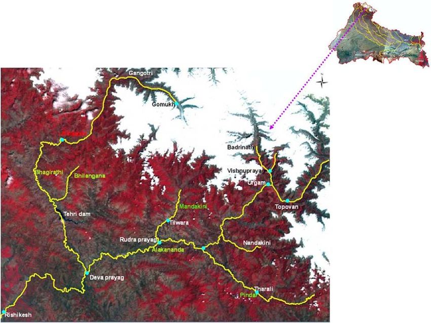
Report Code: 001_GBP_IIT_GEN_DAT_01_Ver 1_Dec 2010

                                         Preface
   In exercise of the powers conferred by sub‐sections (1) and (3) of Section 3 of the
   Environment (Protection) Act, 1986 (29 of 1986), the Central Government has
   constituted National Ganga River Basin Authority (NGRBA) as a planning, financing,
   monitoring and coordinating authority for strengthening the collective efforts of the
   Central and State Government for effective abatement of pollution and conservation of
   the river Ganga. One of the important functions of the NGRBA is to prepare and
   implement a Ganga River Basin: Environment Management Plan (GRB EMP).

   A Consortium of 7 Indian Institute of Technology (IIT) has been given the responsibility
   of preparing Ganga River Basin: Environment Management Plan (GRB EMP) by the
   Ministry of Environment and Forests (MoEF), GOI, New Delhi. Memorandum of
   Agreement (MoA) has been signed between 7 IITs (Bombay, Delhi, Guwahati, Kanpur,
   Kharagpur, Madras and Roorkee) and MoEF for this purpose on July 6, 2010.

   This report is one of the many reports prepared by IITs to describe the strategy,
   information, methodology, analysis and suggestions and recommendations in
   developing Ganga River Basin: Environment Management Plan (GRB EMP). The overall
   Frame Work for documentation of GRB EMP and Indexing of Reports is presented on the
   inside cover page.

   There are two aspects to the development of GRB EMP. Dedicated people spent hours
   discussing concerns, issues and potential solutions to problems. This dedication leads to
   the preparation of reports that hope to articulate the outcome of the dialog in a way
   that is useful. Many people contributed to the preparation of this report directly or
   indirectly. This report is therefore truly a collective effort that reflects the cooperation of
   many, particularly those who are members of the IIT Team. Lists of persons who are
   members of the concerned thematic groups and those who have taken lead in preparing
   this report are given on the reverse side.

                                                                                    Dr Vinod Tare
                                                                        Professor and Coordinator
                                                                        Development of GRB EMP
                                                                                       IIT Kanpur

2|P a g e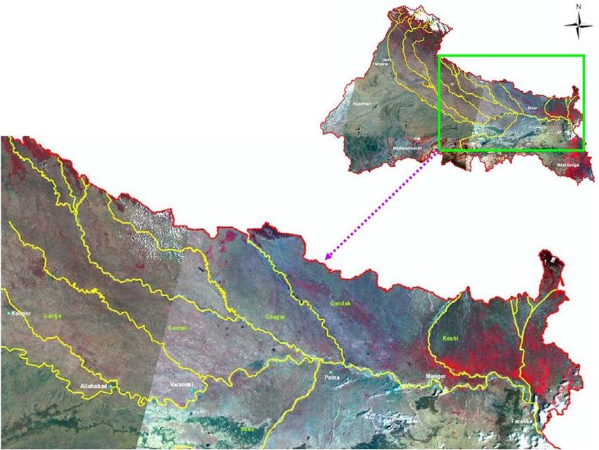
Report Code: 001_GBP_IIT_GEN_DAT_01_Ver 1_Dec 2010

                                            The Team
   1.   Vinod Tare, IIT Kanpur                              vinod@iitk.ac.in
   2.   Rajiv Sinha, IIT Kanpur                             rsinha@iitk.ac.in
   3.   R P Mathur, IIT Kanpur                              rpm_2k1@yahoo.com
   4.   Sandeep Behera, WWF‐India                           sbehera@wwfindia.net

                                         Lead Persons
   1.   Vinod Tare, IIT Kanpur
   2.   R P Mathur, IIT Kanpur

                                          Attributions
   1.   Haridas Mohanta, PhD Scholar, IIT Kanpur
   2.   Lipi Basu, Sr Project Associate, IIT Kanpur
   3.   Rakesh C Mishra, Sr Project Associate, IIT Kanpur
   4.   Shashikant Patel, Project Associate, IIT Kanpur

3|P a g e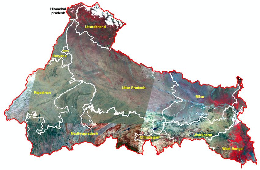
Report Code: 001_GBP_IIT_GEN_DAT_01_Ver 1_Dec 2010

                                  Contents
S No.                                                                        Page No.
  1     Introduction … … … … … … … … … … … … … … … … … … … … … … … … … … … … … …    5
  2     Upper Ganga Segment: Gaumukh to Haridwar … … … … … … … … … … … … … … …                    7
        2.1 Suggestions and Recommendations … … … … … … … … … … … …                              11
  3     Middle Ganga Segment: Haridwar to Varanasi … … … … … … … … … … … … … … …                 12
        3.1   Suggestions and Recommendations … … … … … … … … … … … …                            13

  4     Lower Ganga segment: Varanasi to Ganga Sagar … … … … … … … … … … … … … …                 14
        4.1 Suggestions and Recommendations … … … … … … … … … … … …                              14

   1.

4|P a g e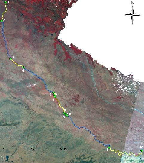
Report Code: 001_GBP_IIT_GEN_DAT_01_Ver 1_Dec 2010

1. Introduction
River systems have been the birthplace of civilizations all over the world. They are woven
into the social and economic fabric of society and penetrate deep into the psyche of the
people living around them. Nowhere is this more evident than in India where the Ganga,
Indus, Narmada and other rivers possess the cultural identity transmitted down the ages
through sacred literature, the Puranas and the Vedas, as well as through popular myths and
legends.
The river Ganga (commonly called as Bhagirathi in the stretch Gangotri to Devprayag and
Hubli in the stretch Farakka to Ganga Sagar) occupies a unique position in the ethos of
people of India. Emotional attachment to the river and the centers of pilgrimage on its
banks runs deep and long in the Indian History.
The Ganga originates from the ice caves at Gaumukh (N 30º55´, E 79º7´) at an elevation of
4100 m. Alaknanda, its main tributary in the mountainous stretch, rises beyond Manna Pass,
8 km form Badrinath (N 30º44´, E 79º41´) at an altitude of 3123 m, and meets at Devprayag.
The Ganga traverses a distance of ≈2510 km from its source to its mouth (Ganga Sagar),
draining eleven states of India (Figure 1). In her course she is joined by many tributaries,
important being Bhilangana, Alaknanda, Ramganga, Kali, Yamuna, Gomti, Ghagra, Gandak,
Kosi and Sone (Figure 2 and 3).
The entire stretch of river Ganga (main stem) can be viewed into three segments:
              A.      Upper Ganga ≈ 294 km         Gaumukh to Haridwar
              B.      Middle Ganga ≈ 1082 km       Haridwar to Varanasi
              C.      Lower Ganga ≈ 1134 km        Varanasi to Ganga Sagar

   Figure 1: Drainage Area of the Ganga River Covering 11 States in India (AIWFS Data)

These three segments not only differ in their geomorphology, ecology and rheology but are
different in terms of issues that need to be addressed:

5|P a g e
Report Code: 001_GBP_IIT_GEN_DAT_01_Ver 1_Dec 2010
A. The river in the upper segment flows on steep and narrow bed, mostly rocks and
boulders, carries cold water, is subjected to much less anthropogenic pollution, has
highly sensitive and fragile ecosystem and biodiversity, and most importantly
considered to have potential for harnessing hydropower.
B. The river in the middle segment enters and flows in plains, meandering mostly on
bed of fine sand, has wide river bed and flood plain, and most importantly modified
through human interventions in terms of huge quantities of water
diversion/abstraction and subjected to high degree of pollutant loads from domestic,
industrial and agricultural activities.
C. The river in the third segment has experienced considerable changes in the sediment
transport and deposition, causes wide spread flooding, undergoes frequent changes
in her channel path, and most importantly is subjected to international disputes on
flows and interventions made and/or are being carried out/planned.
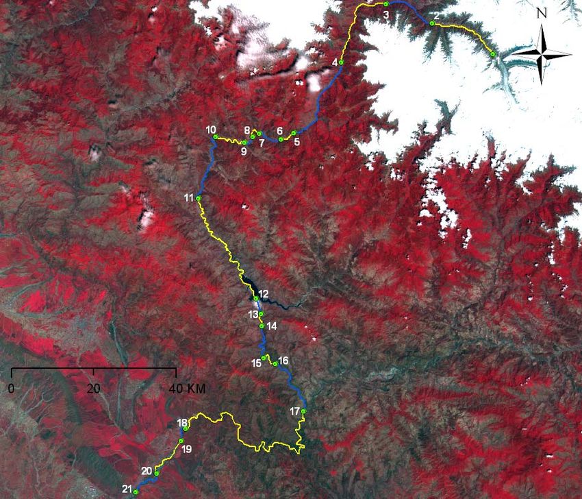
Figure 2: Major Tributaries of River Ganga (Bhagirathi) in the Upper Ganga Segment
6|P a g eReport Code: 001_GBP_IIT_GEN_DAT_01_Ver 1_Dec 2010
Figure 3: Major Tributaries of River Ganga (Bhagirathi) in the Middle and Lower
Ganga Segments
2. Upper Ganga Segment: Gaumukh to Haridwar
In the Upper Ganga Segment (UGS) from Gaumukh to Rishikesh, the river flows mostly on
steep bed with an average approximate slope 1 in 70. The river has turbulent flow and high
velocities in most part of this segment. The habitat is stony intermingled with pebbles and
sand. With limited nutrients in the water body, the growth of phytoplankton and other
aquatic plants is limited. The grazing food chain with fish (carps, occasionally cat fish) as top
species predominates. Mahasheer and Trout have been sighted at many places. Specifically
Trout has been reported at Harshil, Uttara Khand and in one of the tributaries of river Ganga
(i.e. in river Assi, a few thousand meters upstream of its confluence with river Ganga at
Uttarkashi). The phytoplankton is dominated by diatoms (Bacillariophyceae) in winters
followed by green algae (Desmids, Chlorophyceae). The zooplankton is represented mostly
by cilliates. A few rotifers also have been reported.
The most important modifications in the river system in this segment have occurred due to
construction of Run of the River and Run of the River with Ponding (ROR + RORP) hydro‐
electric projects. Location of most of such projects (under operation, construction and
proposed) is presented in Figure 4 and 5. Implementation of these projects have resulted in
significant alteration in hourly, daily and seasonal flows over substantial river length. A
substantial part of the river flow is forced through tunnels or the river stretch has been
7|P a g eReport Code:: 001_GBP_IIT_GEEN_DAT_01_Ver 1_Dec 2010
convertted into deeep impound dments. An estimated 82 km lenggth of the river in this segment
s
out of total
t UGS length (≈ 29 94 km) hass been convverted into impoundm ments or the major
portion of the floww has been n forced into the tunne els and only an estimaated 80 km m stretch
from Gaumukh to o some disttance down nstream of Jhala flowss in natural and near pristine
form. The area und der the influuence of hyydroelectricc projects is suspected to undergo o decline
in its fo
orest coverr and expeerience enh hanced land dslides. Pottential releaase of gree
enhouse
gases from
f impouundments, drying of local waterr resourcess, and dam mage to ressidential
structures, moderation in loccal climate leading to breeding of o mosquito o and otherr insects
causingg health haazard, are also
a reportted. The river ecosysttem is und der stress and
a the
reverinee environmment tends to shift to o lacustrine environmeent. Some salient feattures of
differen
nt stretchess (refer Figure 6) within
n the UGS are presenteed in Exhibitt 1.
Existing: A.
A Badrinath h (1.25MW); B. Tapovan (0.8MW); C. Tharali ((0.2MW); D. Tilwara
(0.2MW); E. Urgam (3 3MW); F. Vishnuprayag (400 MW)
Under Co onstruction: a. Kaliganga‐I (4MW)); b. Kaligaanga‐II(6MW
W); c. Kotli Bhel IB
(93.20MW W); d. Madhm maheswar (110 MW); e.. Topovan Vishnugad(52
V 20 MW); f. Shrinagar
S
(330MW)
Proposed:: 1. Alaknanda (Badrinath) (300MW W); 2. Bagoli (72MW); 3. Bowla Nan ndprayag
(132MW);; 4. Chuni Semi (24MW W); 5. Deoddi (60MW); 6. Devsari Dam (255MW); 7.
Gaurikundd (18.6MW); 8. Gohana Tal (60MW)); 9. Jelam Tamak
T (60MW W); 10. Karn
naprayag
(160MW);; 11. Lakshm manganga (4
4.4MW); 12.. Lata Tapovvan (310MW W); 13. Male eri Jelam
(55MW); 14. Nandpraayag Langassu (141MW)); 15. Padli Dam (27MW W); 16. Phatta‐Byung
(10.8MW)); 17. Rambaara (24MW);; 18. Rishi Ganga‐I
G MW); 19. Rishi Ganga‐II (35MW);
(70M
20. Singolii‐Bhatwari (9
99MW); 21. Tamak
T Lata (280MW);
( 22
2. Urgam‐ II((3.8MW); 23
3. Utiyasu
Dam (860MW); 24. Visshnuprayag Pipalkoti (4444MW)
Figu
ure 4: Hydroelecttric Projectss in Alaknan
nda River B
Basin
8|P a g eReport Code: 001_GBP_IIT_GEN_DAT_01_Ver 1_Dec 2010
Existing: a. Maneri Bhali I (99 MW); b. Maneri Bhali II (304 MW); c. Tehri (1000 MW )
Under Construction : A. Loharinag Pala, now abandoned (600 MW); B. Koteshwar (400
MW); C. Kotli Bhel IA (195MW); D. Kotli Bhel IB (320 MW); E. Kotli Bhel II (530MW); F. Pala
Maneri I (480MW)
Proposed: 1. Bhaironghati I (380 MW); 2. Bhaironghati II (65 MW); 3. Bhilangana I (22.5
MW); 4. Bhilangana II (11 MW); 5. Gangotri (55 MW); 6. Harsil (210 MW); 7. Jadhganga (50
MW); 8. Karmoli (140 MW); 9. Tehri PSS (1000 MW)
Figure 5: Hydroelectric Projects on Ganga (Bhagirathi) and Bhilangana River
9|P a g eReport Code: 001_GBP_IIT_GEN_DAT_01_Ver 1_Dec 2010
Station Longitude, E Latitude, N Elevation, m
1. Gomukh 79.03 30.56 4238
2. Gangotri 78.54 31.00 3037
3. Mukhaba 78.47 31.02 2569
4. Jhala 78.40 30.55 2120
5. MB‐1‐U/S 78.33 30.45 1355
6. MB 1 78.31 30.44 1297
7. MB‐1 Tail water 78.28 30.45 1278
8. MB 2‐U/S 78.27 30.44 1126
9. MB 2 78.26 30.44 1122
10. MB‐2 Tail water 78.21 30.44 1055
11. Tehri Dam U/S 78.19 30.36 845
12. Tehri Dam 78.28 30.23 830
13. Tehri Dam Tail water 78.29 30.21 653
14. Koteswar U/S 78.29 30.20 604
15. Koteswar Dam 78.29. 30.15 555
16. Koteswar Tail water 78.31 30.15 551
17. Devprayag 78.36 30.09 474
18. Rishikesh U/S 78.18 30.06 345
19. Rishikesh Barrage 78.17 30.04 334
20. Satyanarayana 78.14 30.00 316
21. Bheem Gauda Barrage 78.10 29.57 290
Figure 6: Upper Ganga Segments
10 | P a g eReport Code: 001_GBP_IIT_GEN_DAT_01_Ver 1_Dec 2010
Station Longitude, E Latitude, N Elevation, m
1. Bheem Gauda Barrage 78.10 29.57 290
2. Bijnore Barrage 78.02 29.22 221
3. Narora Barrage 78.23 28.11 182
4. Kachla Ghat 78.51 27.56 165
5. Kusumkher 79.56 27.08 130
6. Kannauj U/S 79.59 27.04 128
7. Kannauj D/S 79.59 27.00 127
8. Kanpur Barrage 80.19 26.30 118
9. Shuklaganj 80.22 26.28 116
10. Jajmau 80.24 26.26 115
11. Allahabad 81.53 25.25 76
12. Varanasi 83.01 25.18 74
Figure 7: Middle Ganga Segments
2.1. Suggestions and Recommendations
Gangotri Valley to be viewed as a place of pilgrim tourism and spiritual activities. All
commercial activities in the vicinity of Gangotri (say within 500 m) to be transformed
into eco friendly activities. Plan for environment protection and preservation of natural
and pristine conditions (e.g. hotel culture to be changed to hut culture; severe
restrictions on overnight stay of tourists, promotion of pilgrim tourism than commercial
tourism, facilitating “Pad Yatra”, encouraging use of locally available materials, provision
for segregated collection of entire solid waste of all kinds, entirely eliminating disposal of
11 | P a g eReport Code: 001_GBP_IIT_GEN_DAT_01_Ver 1_Dec 2010
any kind of waste from anthropogenic sources in the valley, complete recycle/reuse and
conversion into acceptable products of wastes generated; sanitation and bathing
facilities with no direct/indirect discharge into river valley, control of noise and artificial
lighting, etc.).
Harshil to be developed as nature friendly, zero waste terminal pilgrim tourist spot with
facilities of ashrams, guest houses, parking, internet, etc.
Environmental Flow (E Flow) to be estimated at various places, particularly for those
stretches where river flow has been modified (IIT Consortia to work on this as part of the
efforts to develop GRBMP). Flow measurement and display devices to be developed for
all such stretches by the project implementer.
All existing hydro electric projects may be redesigned and operated based on
requirement of E flows.
Community toilets and wash rooms with zero discharge of solid and liquid wastes to be
developed at number of places as per approved plan for the entire UGS.
River Bank and River Water Quality Management Plan to be prepared as described in the
report prepared by IIT consortia developing GRBMP for Uttarkashi, Shrinagar, New Tehri
Town, Rudra Prayag, Dev Prayag and Rishikesh on priority.
Eutrophication potential of all impoundments to be assessed and measures taken to
control release of nutrients from point and non‐point sources.
Detailed studies and documentation on changes due to implementation of hydroelectric
projects in the region including, but not limited to the following: (i) drying of local water
sources, (ii) enhancement of landslides, (iii) impact on hills surrounding the
impoundments due to yearly fluctuations in water levels because of filling and emptying,
(iv) damage/changes to residential buildings and hills, (v) potential changes in forest
cover due to draining of waters in the tunnels, (vi) estimation of release of greenhouse
gases from impoundments, (vii) differences in water temperature between a free
flowing river and modified river, (viii) changes in the travel time/distance for local
residents, (ix) employment generation, (x) loss of livelihood for local people, (xi)
rehabilitation issues, (xii) effect of release of E flows on income from power generation,
(xiii) aesthetic value, and (xiv) socio‐cultural aspects (IIT Consortia to make such
documentation as part of GRBMP efforts with help/assistance from concerned agencies
if MOEF provides reports of all studies (including backup data) conducted through
sponsored projects/consultancy assignments given to various agencies, institutions,
universities, etc.).
3. Middle Ganga Segment: Haridwar to Varanasi
The river enters into the plains. The river bed consists of boulders, gravels and sand initially
but subsequently consists of fine sand only. The river bed is essentially flat (slope ≈1 in
5000) and the river channel meanders, bifurcates into several channels in some parts and
consists of dynamic system of pools and riffles. Substantial portion of the river flow is
diverted to support agricultural activities through system of canals referred as Upper Ganga
12 | P a g eReport Code: 001_GBP_IIT_GEN_DAT_01_Ver 1_Dec 2010
Canal (from Bhimgaura Barrage commissioned in 1854 and renovated in 1984‐85 just
upstream of Haridwar), Madhya Ganga Canal (from Bijnore Barrage commissioned in 1977‐
78; essentially flood water or kharif canal system), and Lower Ganga Canal (from Narora
Barrage commissioned in 1878). Substantial amount of flow, conveyed through a feeder
canal originating from the barrage at Kalagarh on the river Ramganga, is introduced into the
river Ganga just downstream of Garhmukteshwar to ensure sufficient quantities of water for
Narora Atomic Power Plant. The confluence of Ramganga at Kusumkher, Kali at Kannauj and
Yamuna at Allahabad augment the flow in the river. However, these rivers, particularly
Ramganga and Kali also bring in a lot of domestic/industrial pollution load. In addition,
several towns, industries and agricultural activities contribute to the point and non‐point
pollution load in this segment. Thus river flow and water quality are the key concerns in this
segment in addition to general degradation of river system and encroachment of river bed,
gravel/sand mining, riverbed farming, active netting of fish, open defecation, etc. In many
places dumping of solid wastes including floral offering and other materials used for
religious purposes, washing of clothes, wallowing of animals, throwing un‐burnt/partially
burnt dead bodies adversely affect aesthetics, water quality and aquatic life. Many
important small, large and mega religious conglomerations are a part of socio‐cultural
dimensions of the riverine system at several places, the most important being at Haridwar,
Allahabad and Varanasi.
In the initial parts of this segment, fish population predominates depending upon grazing
and detritus food chain. The next portion has turtles, crocodiles, ghariyals and Gangetic
dolphin alongwith active breeding sites. Pallaze, a practice to grow cucurbetaceous crop in
the sand bed produced by meandering river is very common. At a number of places water is
pumped out from the river or riverside wells to grow sugarcane and other crops. Riparian
vegetation also is noteworthy. Some salient features of different stretches (refer Figure 7)
within the UGS are presented in Exhibit 2.
3.1. Suggestions and Recommendations
River Bank and River Water Quality Management Plan to be prepared as described
in the report prepared by IIT consortia developing GRBMP for Haridwar,
Garhmukteshwar, Kanpur, Allahabad and Varanasi on priority. IIT consortia to give
priorities for the various work packages in the above plan. The priority work
packages to be executed on fast track as per the guidelines.
Industries directly or indirectly discharging their solid/liquid wastes into Ramganga,
Kali and Ganga must be directed to follow best available practices for managing
solid/liquid wastes and attain complete recycling of water and proper disposal of
solid wastes/sludges as per norms enforced by the regulating agencies.
Ganges Dolphin Conservation Zone Garhmukteshwar – Narora Barrage to be
declared as “NO GO AREA” for which detailed studies have been done by WWF‐
India.
13 | P a g eReport Code: 001_GBP_IIT_GEN_DAT_01_Ver 1_Dec 2010
4. Lower Ganga Segment: Varanasi to Ganga Sagar
In this segment, the river Ganga receives water from three categories of rivers. In the first
category are perennial rivers that originate in Himalayas and carry snow fed flows with
significant discharge in the non‐monsoon season. This includes Kosi, Gandak, Karnali
(Ghaghra) and Mahakali (Sharda) river systems. In the second category are the rivers which
originate in the midlands of Mahabharat range of mountains and are fed by precipitation as
well as ground water, including springs. Mechi, Kankalm, Kamla, Bagmati, West Rapti and
Babai rivers fall under this category. Although these rivers are also perennial, they are
commonly characterized by wide seasonal fluctuations in discharge. The third category of
river systems includes a large number of small rivers in the terrain which originate from the
southern Shiwalik range of hills. These rivers are seasonal with little flows during the dry
season but characterized by flash floods during the monsoon. This part of the basin,
particularly the alluvial belt, is viewed as play ground for many rivers. There is spilling of
river banks and drainage congestion because of peculiar deltaic formation of soil.
Major changes in nature of surface flow have been observed in this segment. This change is
due to the massive silt coming along with the flow. Planning for this massive silt is as
important as the surface water flow itself. The problem of development and water
resources management is highly complex in this segment. Flood, drought and water logging
occur frequently. Flood is a big menace and agriculture is badly affected, though the land is
very fertile.
Several towns, industries and agricultural activities contribute to the point and non‐point
pollution load in this segment. In addition to general degradation of river system,
encroachment of river bed, sand mining, riverbed farming, active netting of fish, open
defecation, etc. are also of concern. In many places dumping of solid wastes including floral
offering and other materials used for religious purposes, washing of clothes, wallowing of
animals, throwing un‐burnt/partially burnt dead bodies adversely affect aesthetics, water
quality and aquatic life. Many important small, large and mega religious conglomerations
are a part of socio‐cultural dimensions of the riverine system at several places, the most
important being at Ganga Sagar where the river merges into the sea. This segment offers
unique biodiversity with many important wetland systems. In some portions Ganges
Dolphins are of great significance from ecological point of view and the general health of the
river system. The food chain is typically detritus with dominance of fishes.
4.1. Suggestions and Recommendations
Hydrological and geomorphological studies for managing sediment transport and water
resources. FGM, WRM and EQP group of IIT Consortia to work on this.
River Bank and River Water Quality Management Plan to be prepared as described in the
report prepared by IIT consortia developing GRBMP for priority towns to be identified
14 | P a g eReport Code: 001_GBP_IIT_GEN_DAT_01_Ver 1_Dec 2010
within the next three months (Action by the EQP group of IIT consortia). IIT consortia to
also give priorities for the various work packages in the above plan. The priority work
packages to be executed on fast track as per the guidelines.
Industries directly or indirectly discharging their solid/liquid wastes into Ganga must be
directed to follow best available practices for managing solid/liquid wastes and attain
complete recycling of water and proper disposal of solid wastes/sludges as per norms
enforced by the regulating agencies.
Exhibit 1: Salient Features in Various Parts of the Upper Ganga Segment
Sub‐Stretch and Its Description
UGS_1: Gaumukh to Gangotri (≈ 19 km)
Represents near natural and pristine conditions; Steep bed with rocks and boulders; No
apparent human intervention and negligible pollution
UGS_2: Gangotri to Mukhoba (≈ 14 km)
Represents near natural and pristine conditions; Known to reemerge as Janhavi river;
narrowest channel; Steep bed with rocks and boulders; Deep Gorges; Slight distributed
pollution due to wastes from eating‐joints on the Gangotri‐shrine; guest houses. Problem of
sanitation is most important.
UGS_3: Mukhoba to Jhala (≈ 22 km)
Represent near pristine and natural conditions; Historical and religious importance due to
joining of three rivers, known as Hari Prayag; Wide flood plain; Flat bed with pebbles and
sand; Meandering and bifurcating into several channels with dynamic system of riffles and
pools; Slight pollution due to domestic and commercial (hotels/guest houses)
establishments
UGS_4: Jhala to U/S MB‐1 (≈ 24 km)
Represents near pristine and natural conditions; Steep and narrow river bed intermingled
with boulders, pebbles and sand; Slight pollution due to domestic activities
UGS_5: MB‐1 U/S to MB‐1 Barrage (≈ 4 km)
Modified to impoundment; Reverine environment shifting to lacustrine environment; Slight
pollution due to domestic activities; High eutrophication potential
UGS_6: MB‐1 Barrage to MB‐1 Tail Waters (≈ 7 km)
Flow substantially reduced; River bed may dry up for sometime; Discontinuity in flow
regime; Aquatic life severely affected
UGS_7: MB‐1 Tail Waters to MB‐2 U/S (≈ 4 km)
Modified fluctuating flows depending upon power generation at MB‐1 power plant;
Additional flows due to Gadera’s; River bed consisting of small stones and pebble; River in
combination of riffles and pools.
UGS_8: MB‐2 U/S to MB‐2 Barrage (≈ 3 km)
Modified to impoundment; Reverine environment shifting to lacustrine environment; Slight
pollution due to domestic activities; High eutrophication potential
15 | P a g eReport Code: 001_GBP_IIT_GEN_DAT_01_Ver 1_Dec 2010 Sub‐Stretch and Its Description UGS_9: MB‐2 Barrage to MB‐2 Tail Waters (≈ 10 km) Flow substantially reduced; River bed may dry up for sometime; Discontinuity in flow regime; Aquatic life severely affected UGS_10: MB‐2 Tail Waters to Tehri U/S (≈ 21 km) Modified fluctuating flows depending upon power generation at MB‐2 power plant; River bed consisting of small stones and pebble; River in combination of riffles and pools. Slight pollution due to domestic activities UGS_11: Tehri U/S to Tehri Dam (≈ 38 km) Modified to impoundment; Reverine environment shifting to lacustrine environment; Slight pollution due to domestic activities; High eutrophication potential; Potential for release of greenhouse gases due to decomposition of submerged biomass in the lake UGS_12: Tehri Dam to Tehri Tail Waters (≈ 4 km) Flow substantially reduced; River bed may dry up for sometime; Discontinuity in flow regime; Aquatic life severely affected UGS_13: Tehri Tail Waters to Koteshwar U/S (≈ 3.5 km) Substantially modified fluctuating flows depending upon power generation at Tehri power plant; River bed consisting of small stones and pebble; River in combination of riffles and pools. Slight pollution due to domestic activities UGS_14: Koteshwar U/S to Koteshwar Dam (≈ 11 km) Will be modified to impoundment; Reverine environment likely to shift to lacustrine environment; Slight pollution due to domestic activities; High eutrophication potential UGS_15: Koteshwar Dam to Koteshwar Tail Waters (≈ 5 km) Flow substantially reduced; River bed may dry up for sometime; Discontinuity in flow regime; Aquatic life severely affected UGS_16: Koteshwar Tail Waters to Dev Prayag (≈ 17 km) Modified fluctuating flows depending upon power generation at Koteshwar power plant; River bed consisting of small stones and pebble; River in combination of riffles and pools. Slight pollution due to domestic activities UGS_17: Dev Prayag to Rishikesh U/S (≈ 64 km) Substantially modified fluctuating flows depending upon power generation at Tehri and Koteshwar power plants; Flow augmented due to confluence with Alaknanda; Hydroelectric projects under construction/proposed on Alaknanda and its tributaries may further influence hourly variation in flow; River bed consisting of small stones and pebble; River in combination of riffles and pools. Slight pollution due to domestic activities, bathing and other cultural religious activities; Initiation of detritus food chain with fish at the top of food chain; Riverine ecosystem under stress due to frequent fluctuations in flow and water quality (e.g. temperature and turbidity) 16 | P a g e
Report Code: 001_GBP_IIT_GEN_DAT_01_Ver 1_Dec 2010

Sub‐Stretch and Its Description
UGS_18: Rishikesh U/S to Rishikesh Barrage (≈ 4 km)
Substantially modified fluctuating flows depending upon power generation at Tehri and
Koteshwar power plants; Flow augmented due to confluence with Alaknanda; Hydroelectric
projects under construction/proposed on Alaknanda and its tributaries may further
influence hourly variation in flow; River bed consisting of large and small pebble with some
boulders and sand; River in combination of riffles and pools. Slight pollution due to
domestic activities, bathing and other cultural/religious activities; Development of detritus
food chain with fish at the top of food chain; Riverine ecosystem under stress due to
frequent fluctuations in flow and water quality (e.g. temperature and turbidity)
UGS_19: Rishikesh Barrage to Satyanarayana (≈ 11km)
Flow pattern modified depending upon modified fluctuating flow received from upstream
and power generation at Chilla power station; River bed consisting of small stones and
pebble; Active fish breeding area; Fish netting and rampant stone mining; Riverine
ecosystem under stress due to frequent fluctuations in flow and water quality (e.g.
temperature and turbidity)
UGS_20: Satyanarayana to Bhim Gauda Barrage (≈ 9 km)
Flow pattern modified depending upon modified fluctuating flow received from upstream;
Wide flood plain; Flat bed with pebbles and sand; Meandering and bifurcating into several
channels with dynamic system of riffles and pools; Much of the water diverted to Har‐ki‐
paudi through canal and much less water released in the main stream as Neel Dhara;
Moderate pollution due to domestic and commercial (hotels/guest houses) establishments

           Exhibit 2: Salient Features in Various Parts of the Middle Ganga Segment
Sub‐Stretch and Its Description
MGS_1: Bheem Gauda Barrage to Bijnor Barrage (≈ 82 km)
Most of the water is diverted to Har‐ki‐Paudi; Excess flow from canals is returned at 6‐8 km
downstream; Wide flood plain, River meandering and bifurcating into several channels;
River bed consisting of pebble and sand; Reported re‐appearance of Mahasheer at Balawali;
Occurrence of Otters, Crocodiles, Ghariyal, Turtle in some parts indicating good biodiversity;
Active breeding grounds for fish in some parts; Moderate pollution due to domestic and
agricultural activities.
MGS_2: Bijnor Barrage to Narora Barrage (≈ 176 km) NO GO ZONE
Low flow during non‐monsoon period in the initial portion of the stretch up to
Garhmukteshwar; Subsequently flow modified through discharge of Ramganga waters
through feeder canal; Impoundment and abstraction of water through Lower Ganga Canal
system at the tail end; Wide flood plain and sandy bed with some pebbles; Ganges Dolphin
conservation site; Moderate pollution due to domestic and agricultural activities

17 | P a g e
Report Code: 001_GBP_IIT_GEN_DAT_01_Ver 1_Dec 2010 Sub‐Stretch and Its Description MGS_3: Narora Barrage to Kachla Ghat (≈ 70 km) Extremely low flows during non‐monsoon period; Only occasional releases of water during non‐monsoon period; Wide flood plain; Meandering river with dynamic system of pools and riffles; Sandy bed; Breeding site for Turtles and Ghariyal; Agricultural activities in river bed, predominantly Cucurbetaceous crops known as “Pallaze”; Significant degradation of river water quality. MGS_4: Kachla Ghat to Kusumkher (≈ 182 km) Extremely low flows during non‐monsoon period; Only occasional releases of water during non‐monsoon period; Wide flood plain; Meandering river with dynamic system of pools and riffles; Sandy bed; Agricultural activities in river bed, predominantly Cucurbetaceous crops known as “Pallaze”; Significant degradation of river water quality. MGS_5: Kusumkher to Kannauj U/S (≈ 12 km) Additional flow and pollutant load from river Ramganga; Low flows during non‐monsoon period; Only occasional increase in flows during non‐monsoon period; Wide flood plain; Meandering river with dynamic system of pools and riffles; Sandy bed; Agricultural activities in river bed, predominantly Cucurbetaceous crops known as “Pallaze”; Use of excessive pesticides. Significant degradation of river water quality. MGS_6: Kannauj U/S to Kannauj D/S (≈ 9 km) Additional highly polluted flow from river Kali; Low flows during non‐monsoon period; Only occasional increase in flows during non‐monsoon period; Wide flood plain; Meandering river with dynamic system of pools and riffles; Sandy bed; Agricultural activities in river bed, predominantly Cucurbetaceous crops known as “Pallaze”; Use of excessive pesticides. Significant degradation of river water quality. MGS_7: Kannauj D/S to Kanpur Barrage (≈ 78 km) Low flows during non‐monsoon period; Only occasional increase in flows during non‐ monsoon period; Wide flood plain; Meandering river with dynamic system of pools and riffles; Sandy bed; Impoundment in the part downstream of Bithoor near Barrage; Ganges Dolphins Spotted; Agricultural activities in river bed, predominantly Cucurbetaceous crops known as “Pallaze”; Use of excessive pesticides. Significant degradation of river water quality. MGS_8: Kanpur Barrage to Shuklaganj (≈ 7.5 km) Low flows during non‐monsoon period; Only occasional increase in flows during non‐ monsoon period; Wide flood plain; Meandering river with dynamic system of pools and riffles; Sandy bed; Agricultural activities in river bed, predominantly Cucurbetaceous crops known as “Pallaze”; Use of excessive pesticides. Extensive degradation of river water quality due to domestic and industrial wastes, dumping of solid wastes, animal wallowing, throwing of un‐burnt dead bodies. 18 | P a g e
Report Code: 001_GBP_IIT_GEN_DAT_01_Ver 1_Dec 2010

Sub‐Stretch and Its Description
MGS_9: Shuklaganj to Jajmau (≈ 5.5 km)
Low flows during non‐monsoon period; Only occasional increase in flows during non‐
monsoon period; Wide flood plain; Meandering river with dynamic system of pools and
riffles; Sandy bed; Agricultural activities in river bed, predominantly Cucurbetaceous crops
known as “Pallaze”; Use of excessive pesticides. Extensive degradation of river water quality
due to domestic and industrial wastes, dumping of solid wastes, animal wallowing,
throwing of un‐burnt dead bodies; The most critical stretch.
MGS_10: Jajmau to Allahabad (≈ 247 km)
Low flows during non‐monsoon period; Only occasional increase in flows during non‐
monsoon period; Wide flood plain; Meandering river with dynamic system of pools and
riffles; Sandy bed; Agricultural activities in river bed, predominantly Cucurbetaceous crops
known as “Pallaze”; Use of excessive pesticides. Discharge of domestic and some industrial
wastes, dumping of solid wastes, animal wallowing, throwing of un‐burnt dead bodies;
Gradual but very slow recovery of the river system; Ganges Dolphin spotted; Several
important major and mega religious/cultural conglomeration held on the riverside.
MGS_11: Allahabad to Varanasi (≈ 212 km)
Slight increase in flow due to joining of a major tributary Yamuna; Wide flood plain;
Meandering river with dynamic system of pools and riffles; Sandy bed; Agricultural activities
in river bed, predominantly Cucurbetaceous crops known as “Pallaze”; Use of excessive
pesticides. Discharge of domestic and some industrial wastes, dumping of solid wastes,
animal wallowing, throwing of un‐burnt/half burnt dead bodies; Ganges Dolphin spotted.

19 | P a g e
You can also read