Beaulieu River Sanitary Survey Review February 2015 - Cefas
←
→
Page content transcription
If your browser does not render page correctly, please read the page content below
www.cefas.co.uk

Beaulieu River Sanitary Survey
Review
February 2015
Cover photo: Looking south from Beaulieu village © Crown copyright 2015 This document/publication is also available on our website at: https://www.cefas.co.uk/publications-data/food-safety/sanitary-surveys/england-and-wales/ Contacts For enquires relating to this report or further For enquires relating to policy matters on the information on the implementation of implementation of sanitary surveys in sanitary surveys in England and Wales: England: Simon Kershaw Karen Pratt Food Safety Group Hygiene Delivery Branch Cefas Weymouth Laboratory Enforcement and Delivery Division Barrack Road Food Standards Agency The Nothe Aviation House Weymouth 125 Kingsway Dorset London DT4 8UB WC2B 6NH +44 (0) 1305 206600 +44 (0) 207 276 8970 fsq@cefas.co.uk shellfishharvesting@foodstandards.gsi.gov
Statement of use

Under EC Regulation 854/2004 which lays down specific rules for official controls on
products of animal origin intended for human consumption, a sanitary survey relevant to
bivalve mollusc beds in Beaulieu River was undertaken in 2009. This provided an
appropriate hygiene classification zoning and monitoring plan based on the best available
information with detailed supporting evidence. The Food Standards Agency (FSA) is
committed to reviewing sanitary surveys every six years or sooner if significant changes in
pollution sources or the fishery have occurred that may require revision of the sampling plan.
This report provides a six year review of information and recommendations for a revised
sampling plan. The Centre for Environment, Fisheries & Aquaculture Science (Cefas)
undertook this work on behalf of the FSA.

Revision history
 Version   Details                               Approved by       Approval date
 1         Draft for internal review             David Walker      10/03/2015
 2         Draft for external review             Simon Kershaw     23/03/2015
 Final     Final report post consultation        Simon Kershaw     17/06/2015

Consultation
 Consultee                                  Date of consultation   Date of response
 New Forest District Council                     23/03/2015        26/03/2015
 Southern IFCA                                   23/03/2015        None
 Environment Agency                              23/03/2015        31/03/2015
 Southern Water                                  23/03/2015        None
 Natural England                                 23/03/2015        23/04/2015

Dissemination
Food Standards Agency, New Forest District Council. The report is available publicly via the
Cefas website.

Recommended Bibliographic Reference
Cefas, 2015. Review of the Beaulieu River 2009 Sanitary Survey. Cefas report on behalf of
the Food Standards Agency, to demonstrate compliance with the requirements for
classification of bivalve mollusc production areas in England and Wales under EC
Regulation No. 854/2004.
Contents
1. Introduction ...................................................................................................................... 5
   1.1. Background ............................................................................................................... 5
   1.2. Beaulieu River Review .............................................................................................. 5

2. Shellfisheries ................................................................................................................... 7
   2.1. Description of shellfishery ......................................................................................... 7
   2.2. Classification History ................................................................................................. 7

3. Overall Assessment ......................................................................................................... 9

4. Sampling Plan ................................................................................................................ 11
   4.1. Recommendations .................................................................................................. 11
   4.2. General information ................................................................................................. 12

5. Pollution sources ........................................................................................................... 16
   5.1. Human Population ................................................................................................... 16
   5.2. Sewage ................................................................................................................... 17
   5.3. Livestock ................................................................................................................. 22
   5.4. Wildlife ..................................................................................................................... 23

6. Hydrodynamics .............................................................................................................. 24

7. Rainfall ........................................................................................................................... 25

8. Microbial Monitoring Results .......................................................................................... 26

9. References .................................................................................................................... 33

Acknowledgements ............................................................................................................ 34

Appendices ........................................................................................................................ 35
   Appendix I. Shoreline Survey ......................................................................................... 36
   Appendix II. Beaulieu River Sanitary Survey Report 2009 ............................................. 50
1. Introduction

1.1. Background
The Centre for Environment, Fisheries & Aquaculture Science (Cefas) is performing sanitary
surveys for new bivalve mollusc production areas (BMPAs) in England and Wales, on behalf
of the Food Standards Agency (FSA). The purposes of the sanitary surveys are to
demonstrate compliance with the requirements stated in Annex II (Chapter II paragraph 6)
of EC Regulation 854/2004, whereby ‘if the competent authority decides in principle to
classify a production or relay area it must:
(a) make an inventory of the sources of pollution of human or animal origin likely to be a
    source of contamination for the production areas;
(b) examine the quantities of organic pollutants which are released during the different
    periods of the year, according to the seasonal variations of both human and animal
    populations in the catchment area, rainfall readings, waste-water treatment, etc.;
(c) determine the characteristics of the circulation of pollutants by virtue of current patterns,
    bathymetry and the tidal regime in the production area; and
(d) establish a sampling programme of bivalve molluscs in the production area which is
    based on the examination of established data, and with a number of samples, a
    geographical distribution of the sampling points and a sampling frequency which must
    ensure that the results of the analysis are as representative as possible for the area
    considered.’
In line with the EU Good Practice Guide Cefas is contracted to undertake reviews of sanitary
surveys on behalf of the Food Standards Agency. Reviews are to be undertaken at six yearly
intervals after the original sanitary survey or sooner where there are changes to the type
and locations of the shellfisheries or significant changes in sources of pollution.

1.2. Beaulieu River Review
This report reviews available information and makes recommendations for a revised
sampling plan for the existing native oyster and Tapes spp. classification zones in the
Beaulieu River production area. This review identifies changes to the information presented
in the sanitary survey through a desk based study and updates the assessment and
sampling plan where necessary.

Specifically, the review will consider:
(a) changes to the shellfishery
(b) changes in microbiological monitoring results
(c) changes in sources of pollution impacting the production area or new evidence relating
    to the actual or potential impact of sources
(d) changes in land use in the area
(e) change in environmental conditions

Beaulieu River Sanitary Survey Review 2015 - Introduction                                      5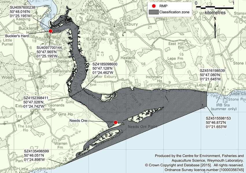
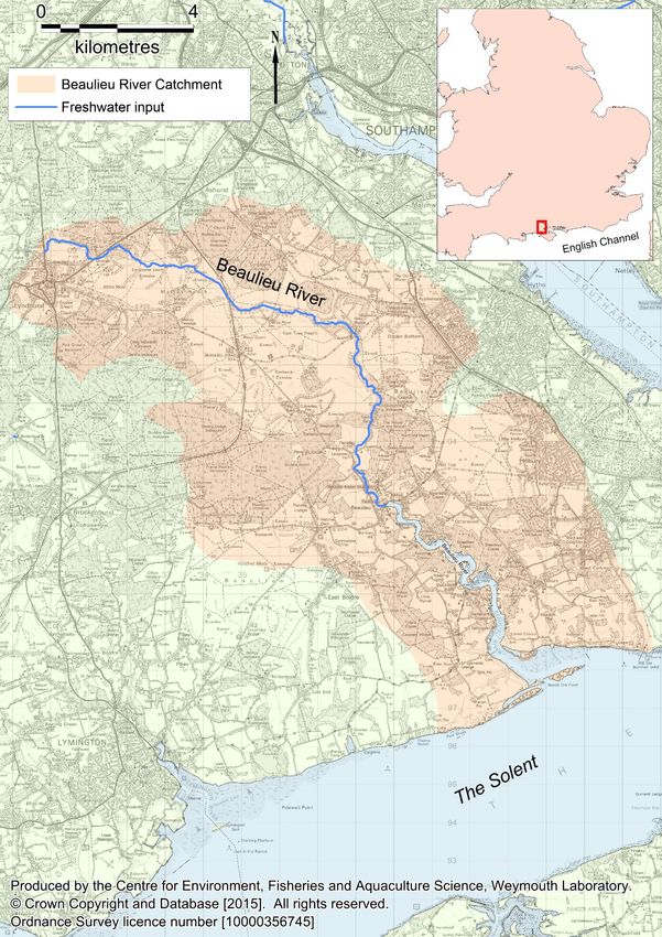
Figure 1.1: Location of Beaulieu River

Beaulieu River Sanitary Survey Review 2015 - Introduction                 6
2. Shellfisheries

2.1. Description of shellfishery
Harvesting of shellfish in the Beaulieu River is subject to lease from the Beaulieu Estate. At
present, while a lease is held, there is no legal harvesting of shellfish taking place in the
Beaulieu River. Harvesting of Manila clams is prohibited due to high historical E. coli levels.
Native oysters are currently not classified due to a lack of a viable stock for harvesting, and
as such are subject to a Southern IFCA temporary closure of shellfish beds byelaw
(Southern IFCA, 2014).

When in operation, both Manila clams and native oysters are harvested by dredge.
According to the lease holder, the highest concentration of Manila clams is between
Carpenters Dock and Bailey’s Hard (Figure 2.1). The majority of this high density area is
upstream of the prohibited Manila clam zone. The lease holder suspects that the Beaulieu
Village WwTW is the main source of contamination for Manila clams and plans to take
sediment samples at intervals extending away from this discharge. No indication was given
of when this may take place. In 2013 an application to change the extent of the Manila clam
classification zone was made. Following the 2013 application, a new classification zone was
drawn which covers a smaller area of the river than was classified prior to 2013, further
downstream, and potentially further away from contamination sources. A total of eight
samples were taken from this proposed classification zone in November and December
2013. Not enough samples were taken for a provisional classification to be granted,
however, the E. coli results from these samples indicated that a C classification would be
probable.

Native oysters were classified in the Beaulieu south of Buckler’s Hard until 2011. Since that
time oysters have not been classified due to a lack of commercially available stock. The
harvester expressed an interest in carrying out their own survey to establish the current
distribution of native oysters in the lower Beaulieu and getting the area reclassified.

2.2. Classification History
Table 2.1 lists classifications within the Beaulieu River since 2005 and Figure 2.1 shows the
locations of classification zones. Bailey’s Hard Manila clam classification zone has been
prohibited since 2013 due to high E. coli results. Following a decline in the native oyster
population, sampling for native oysters stopped in 2010, and this species has remained
unclassified since.

Beaulieu River Sanitary Survey Review 2015 - Shellfisheries                                  7
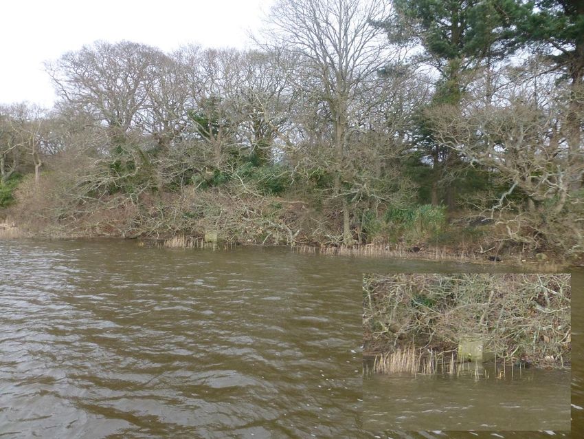
Table 2.1: Classification history for the Beaulieu River
2005
2006
2007
2008
2009
2010
2011
2012
2013
2014
Bed name Species
Buckler’s Hard B B-LT B-LT B-LT B-LT B-LT - - - -
Native oysters
Needs Ore B-LT B-LT B-LT B-LT B-LT B-LT - - - -
Bailey’s Hard Manila clams - - - - - - C C P P
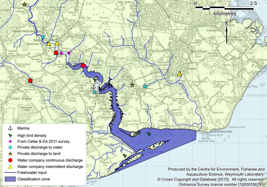
Figure 2.1: Locations of the classification zones for Manila clams and native oysters (historic) in the
Beaulieu River. According to the lease holder there are high density stocks of Manila clams between
Carpenter’s Dock and Bailey’s Hard.
Beaulieu River Sanitary Survey Review 2015 - Shellfisheries 8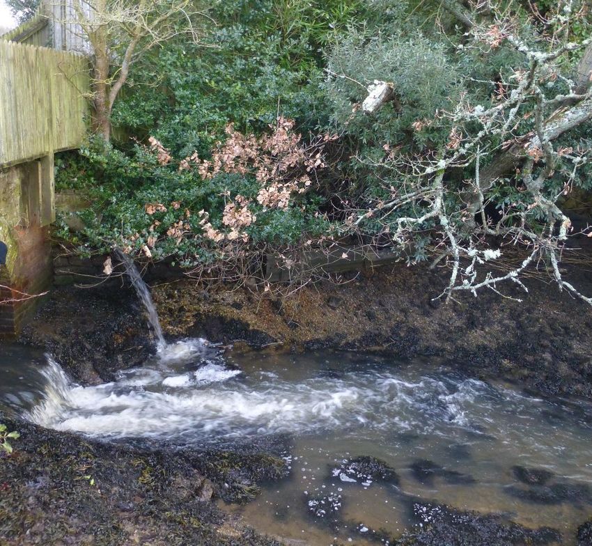
3. Overall Assessment
All of the shellfish beds in the Beaulieu River are currently closed due either to prohibitive
classification results or low stock numbers. The lease holder would like to be able to harvest
Manila clams, and although the clam stocks are denser upstream, it is more desirable to
harvest from a lower density stock with lower levels of contamination. For this reason,
sampling towards reclassifying a smaller clam classification zone started in 2013, but was
never completed. No recent stock surveys have been performed for either Manila clams or
native oysters.

The human population in the catchment rose by 2.2% between the 2001 and 2011
censuses. The majority of this population rise was in the east of the catchment around
Dibden Purlieu and Holbury. The volume of sewage discharged may have increased in
response.

With the exception of a small increase in permitted dry weather flow at East Boldre sewage
treatment work (STW), 2.2%, and some maintenance works to the Beaulieu Village
Wastewater Treatment Works (WwTW) there have been no significant reported changes to
the three water company owned continuous discharges in the catchment. There are 10
intermittent water company owned discharges in the Beaulieu catchment. The Beaulieu
Village WwTW has spilled for approximately 10% of the time since 2009 and is probably a
significant source of contamination to shellfish in the river. While the Lyndhurst WwTW
overflow also spilled for approximately 10% of the time, it is further up catchment and is less
likely to have a large impact on the shellfish. Within the catchment there are 11 private
discharges with maximum flows exceeding 5 m³/day. The level of treatment for these
discharges is not reported and so it is difficult to quantify the impact that they have on
shellfish hygiene. However, it is reported by the EA that the discharge from the National
Motor Museum has improved since 2009.

There may have been an overall decline in livestock numbers since the 2009 sanitary
survey, but no reliable catchment level data were freely available for the current report.
Overall bird numbers have fluctuated since 2008, but were at comparable levels to
2008/2009 during the last reported surveying period (2012/2013).

There have been no significant changes to the bathymetry or other hydrographical features
in the estuary since 2009.

A survey by Cefas and the Environment Agency (EA) (Cefas and EA, 2011) found three
highly contaminated points on the estuary. These were a spring near Carpenters Dock, a
spring at Oxleys and a private discharge just to the east of Hummicks WwTW.

Beaulieu River Sanitary Survey Review 2015 – Overall assessment                              9
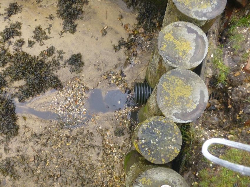
Figure 3.1: Summary of contamination sources to shellfish in the Beaulieu Estuary

Beaulieu River Sanitary Survey Review 2015 – Overall assessment                                         10
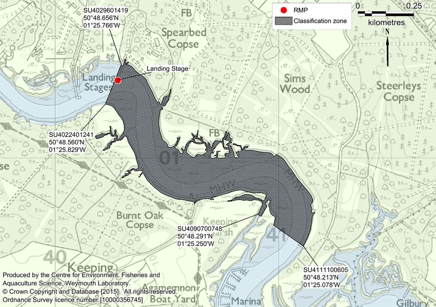
4. Sampling Plan

4.1. Recommendations
It is recommended that all classification zones and RMPs in the Beaulieu River stay in their
current locations. For Manila clams, the reduced classification zone and RMP as set out by
the 2013 RMP assessment (Cefas, unpublished) should be used.

Manila clams (Tapes spp.)
Landing Stages – The classification zone for Manila clams should follow the
recommendations previously set out by Cefas in the 2013 RMP assessment (Cefas,
unpublished). The RMP for this classification zone should be located at the upstream most
point of the classification zone in order to account for contamination from the Beaulieu River
catchment as well as both the Beaulieu Hummicks and Beaulieu Village WwTWs.

Native Oysters (O. edulis)
Buckler’s Hard – This classification zone encompasses the native oysters from just
downstream of Buckler’s Hard to Gins and the iron-age fort at Lower Exbury. The RMP for
this zone should be located at the most upstream point of the classification zone to account
for contamination from the Beaulieu River catchment and upstream sewage discharges.

Needs Ore – This classification zone encompasses the native oysters from Gins and the
iron-age fort at Lower Exbury to the extent of the Beaulieu River lease. The RMP for this
zone should be located to the west of the zone to account for contamination from the bird
colony at Needs Ore Point.

Beaulieu River Sanitary Survey Review 2015 – Sampling plan                                 11
4.2. General information
Location Reference
       Production area                        Beaulieu Estuary

       Cefas main site reference              M023

       Ordnance Survey 1:25,000 map           OL22 (New Forest)

       Admiralty charts                       No. 2021

Shellfishery
                                  Manila clams (Tapes spp)            Wild
       Species/culture
                                  Native oysters (Ostrea edulis)      Wild

       Seasonality of             Year round
       harvest

Local Enforcement Authority
       Name                                   New Forest District Council

       Environmental health officer           Dale Bruce

       Telephone number                       02380 285000

       Email                                  dale.bruce@nfdc.gov.uk

Requirement for review
The Guide to Good Practice for the Microbiological Monitoring of Bivalve Mollusc Harvesting
Areas (EU Working Group on the Microbiological Monitoring of Bivalve Mollusc Harvesting
Areas, 2014) indicates that sanitary assessments should be fully reviewed every six years.
This assessment is therefore due for formal review in 2021. The assessment may require
review in the interim should any significant changes in sources of contamination come to
light.

Beaulieu River Sanitary Survey Review 2015 – Sampling plan                              12
Table 4.1: Number and location of representative monitoring points (RMPs) and frequency of sampling for classification within Beaulieu Estuary
Latitude &
Classification Growing Harvesting Sampling Sampling
RMP† RMP name NGR longitude Species Tolerance Frequency
zone method technique method species
(WGS84)
50°48.618'N
Landing Stage B023I Landing Stage SU4028001350 Manila clams Wild Dredge Dredge Manila clams 50 m Monthly
01°25.780'W
50°47.979'N
Buckler’s Hard B023A Buckler’s Hard SU4098000170 Wild Dredge Dredge Native oysters 50 m Monthly
01°25.192'W
Native oysters
50°46.655'N
Needs Ore B023B Needs Ore SZ4272097730 Wild Dredge Dredge Native oysters 50 m Monthly
01°23.728'W
Beaulieu River Sanitary Survey Review 2015 – Sampling plan 13Figure 4.1: Recommended zoning and monitoring arrangements (Manila clams) Beaulieu River Sanitary Survey Review 2015 – Sampling plan 14
Figure 4.2: Recommended zoning and monitoring arrangements (native oysters)

Beaulieu River Sanitary Survey Review 2015 – Sampling plan                                           15
5. Pollution sources
5.1. Human Population
In the 2009 Beaulieu River Sanitary Survey Report, the population data presented were
collected in the 2001 census. Another census in 2011 was conducted since the report was
written, and so changes in the human population in the catchment are discussed here.
Figure 5.1 shows population densities in census Lower Layer Super Output Areas (LSOAs)
within or partially within the Beaulieu River catchment area, derived from data collected from
the 2001 and 2011 censuses. An overall trend of increased population density is apparent
with the average population density across the catchment increasing by 3.6%. Most of this
increase has occurred in the east of the catchment around Dibden Purlieu and Holbury.
Figure 5.1: Human population density in 2001 and 2011 census LSOAs in the Beaulieu River
catchment.
Total resident population within the census areas contained within or partially within the
catchment area was approximately 32,273 in 2001 and 32,992 in 2011. This is an increase
of around 2.2% at the time of the 2011 census.
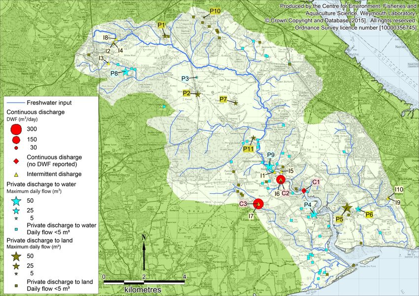
Beaulieu River Sanitary Survey Review 2015 – Pollution Sources 165.2. Sewage Figure 5.2 shows the locations of all of the current discharges identified in the Environment Agency (EA) national permit database (July 2014) which fall within the Beaulieu catchment. The 2009 sanitary survey only reported a small number of discharges and did not include those in the upper catchment. There are three water company owned continuous discharges (Table 5.1) within the catchment, all of which were reported in the 2009 sanitary survey report. Two of these discharges had dry weather flows (DWF) reported in the current EA national permit database. East Boldre STW previously had a DWF of 278 m³/day, but this has since increased to 284 m³/day. The Beaulieu Village WwTW has had no reported change to its DWF and Beaulieu Hummicks WwTW has no reported DWF. Treatment levels for Beaulieu Hummicks WwTW and East Boldre STW are not reported but it is assumed that they remain with a secondary level of treatment as in the 2009 sanitary survey as there have been no changes planned for these discharges (EA, 2009). According to the EA, final effluent monitoring of the Beaulieu Village WwTW between 2013 and 2015 has showed a consistent improvement in water quality (I. Udal, personal communication 10/02/2015). There are ten water company owned intermittent discharged that are consented within the Beaulieu catchment (Table 5.2). Two of these were reported in the 2009 report. Table 5.4 and Figure 5.3 show the spills from the Beaulieu Village WwTW, East Boldre STW and Lyndhurst WwTW intermittent discharges. The spill data for East Boldre STW and Lyndhurst WwTW were not available between 2006 and 2009 or in 2014 at the time of writing. All of the discharges have spilt for more than 3% of the time in at least one of the years that data were available. Beaulieu Village WwTW and Lyndhurst WwTW discharges spilt very often, with Lyndhurst WwTW spilling for more than 3% of the time in all years where data were available. There are also 95 private discharges in the catchment, 11 of which have consented maximum daily flows equal to or greater than 5 m³/day (Table 5.3). One of these was reported in the 2009 sanitary survey report (National Motor Museum). Improvements to this discharge have resulted in better quality final effluent (I. Udal, personal communication, 10/02/2015). The other private discharge reported in the 2009 sanitary survey, Agamemnon Boatyard, no longer has a reported maximum daily flow consent. Following Cefas and EA investigations (Cefas and EA, 2012), a small but heavily contaminated private discharge at Burnt Copse just to the east of Beaulieu Hummicks WwTW has been improved (EA, 2014). There have also been improvements to some of the minor discharges from the Beaulieu Estate (I. Udal, personal communication, 10/02/2015). Beaulieu River Sanitary Survey Review 2015 – Pollution Sources 17
Figure 5.2: Discharges in the Beaulieu catchment (Table 5.1, Table 5.2, and Table 5.3 for details)
                                     Contains Environment Agency information © Environment Agency and database right

Beaulieu River Sanitary Survey Review 2015 – Pollution sources                                       18
Table 5.1: Continuous water company discharges within the Beaulieu catchment.
Number Name in current Name in 2009 report NGR Treatment Dry weather Receiving Distance to Estimated
on map database flow environment classification daily
(m³/day) zone (km) loading†
C1 Beaulieu Hummicks Beaulieu Hummicks SU4028001350 Unknown* NR Saline Estuary 0.0 -
WwTW STW
C2 Beaulieu Village WwTW Beaulieu Village STW SU3913001900 2° (biological 216 Saline Estuary 0.9 7.1x10¹¹
filtration)
C3 East Boldre S.T.W. East Boldre STW SU3802000700 Unknown* 284 Freshwater river 4.9 9.4x10¹¹
Contains Environment Agency information © Environment Agency and database right
*Reported as secondary in 2009 sanitary survey, but no information in current database
†
E. coli cfu/day (data from Kay et al. 2008),
NR=Not Reported
Table 5.2: Intermittent water company discharges within the Beaulieu catchment. Grey cells indicate
discharges used in Table 5.4 and Figure 5.3.
Number Name in current database Name in 2009 report NGR Receiving Distance to
on map environment classification zone (km)
I1 Beaulieu Village PS Fire Station Lane SPS CSO SU3882002290 Saline Estuary 1.5
I2 Lyndhurst Pumping Station SU3085008670 Freshwater river 16.3
I3 Green Lane Lyndhurst CEO SU3060007660 Freshwater river 16.6
I4 Lyndhurst Golf Club CEO SU3084008670 Freshwater river 16.3
I5 Palace Lane/Dock Lane CSO SU3916002310 Saline Estuary 1.2
I6 Beaulieu Village WwTW Beaulieu Village STW CSO SU3913001900 Saline Estuary 0.9
I7 East Boldre S.T.W. SU3802000700 Freshwater river 4.9
I8 Lyndhurst WwTW SU3098408859 Freshwater river 16.1
I9 West Common road Fawley CEO SU4444000990 Fresh water river 3.5
I10 West Common PS SU4446001010 Fresh water river 3.5
Contains Environment Agency information © Environment Agency and database right
Beaulieu River Sanitary Survey Review 2015 – Pollution sources 19Table 5.3: Private discharges within the Beaulieu catchment with maximum daily flows above 5 m³.
Number on Name in current database Name in 2009 report NGR Maximum Receiving environment Distance to
map daily flow (m³) classification
zone (km)
P1 Ashurst Lodge SU3340009010 18 Land 13.4
P2 Beaulieu Road Hotel SU3502006130 25 Land 9.6
P3 Beaulieu Road Station SU3497006960 5 Freshwater river 11.1
P4 Bucklers Hard Village STW SU4078000200 38 Saline Estuary 0.2
P5 Exbury Plant & Garden Centre SU4241000520 60 Land 0.8
P6 Exbury Sewage Works SU4297000450 24 Freshwater river 5.0
P7 Ferny Crofts SU3690005690 15 Land 7.7
P8 Limewood Hotel, Parkhill SU3145407250 40 Freshwater river 15.5
P9 National Motor Museum National Motor Museum SU3857002570 50 Freshwater river 2.1
P10 New Forest Otter Owl & Wildlife Pk SU3533009920 5 Land 11.2
P11 Seas Worker Accom Penerly Farm SU3777503980 15 Land 4.3
Contains Environment Agency information © Environment Agency and database right
Table 5.4: Spills from intermittent discharges in the Beaulieu catchment. Years where a discharge was spilling for 3% or more of the time are highlighted
in yellow.
No of spills/ year % time spilling
Discharge 2006 2007 2008 2009 2010 2011 2012 2013 2014 2006 2007 2008 2009 2010 2011 2012 2013 2014
Beaulieu Village WwTW 31 54 20 65 58 19 60 42 54 2.3 10.8 2.3 14.0 12.8 2.8 9.7 8.3 11.6
East Boldre S.T.W. NDP 11 NDP 43 6 NDP NDP 1.5 NDP 9.4 0.6 NDP
Lyndhurst WwTW NDP 18 41 57 53 NDP NDP 3.1 7.5 12.5 9.9 NDP
Contains Environment Agency information © Environment Agency and database right
NDP = No data provided
Beaulieu River Sanitary Survey Review 2015 – Pollution sources 20Figure 5.3: Bubble plot of spills from intermittent discharges in the Beaulieu catchment.
Contains Environment Agency information © Environment Agency and database right
Beaulieu River Sanitary Survey Review 2015 – Pollution sources 215.3. Livestock
Livestock data were not freely available for the same area assessed in the sanitary survey
report (Beaulieu River Catchment). However, the livestock numbers for the New Forest
district were available for 2007 and 2013 (Defra, 2014). As the Beaulieu River catchment
only makes up approximately 15% of the total New Forest District area, the livestock
numbers for the Beaulieu River catchment were estimated using the % difference in
numbers for the entire district and the 2007 numbers for the catchment presented in the
2009 sanitary survey. These estimates assume that the changes in livestock numbers were
uniform across the district, and so may not be a true representation of livestock numbers in
the catchment. The reported and estimated livestock numbers are presented in Table 5.5.
There has been an overall decline in livestock numbers across the catchment for all livestock
types. The largest decline was for poultry (-63.9%). The decline in livestock may have
resulted in a decline of faecal contamination to the Beaulieu River. However, it should be
noted that these numbers may not be truly representative.
Table 5.5: Livestock data for the Beaulieu river catchment in 2007 and 2013*.
New Forest Beaulieu Catchment
Poultry 2007 617,937 393
2013 222,997 142*
% difference -63.9
Pigs 2007 19,472 4,923
2013 11,591 2,930*
% difference -40.5
Cattle 2007 16,591 3,097
2013 14,377 2,684*
% difference -13.3
Sheep 2007 10,173 270
2013 9,906 263*
% difference -2.6
Data from Defra (2014)
*value calculated from % difference
Beaulieu River Sanitary Survey Review 2015 – Pollution sources 225.4. Wildlife
Figure 5.4 shows the peak counts for overwintering birds in the Beaulieu Estuary from 2008
to 2013 (Austin et al., 2014). Bird numbers have varied since 2008, with an increase in
wildfowl numbers in 2009/10 and a fall in wader numbers from 2008/09 to 2010/11. However
numbers of all of the reported bird groups returned to similar values in 2012/13 to those in
2008/09. The most numerous bird types in the Beaulieu estuary are waders and wildfowl.
Total bird distributions reported by Musgrove et al. (2003) showed that there were large
concentrations of birds in the north of the estuary from the tidal limit at Beaulieu village, to
Bailey's Hard. There were also dense populations on Keeping Marsh, just north of Buckler's
Hard. There were also high densities of birds on the marshes in the lower estuary seaward
from Lower Exbury/Royal Southampton Yacht club. Much of this information was
corroborated by literature and the shoreline survey reported in the 2009 sanitary survey.
There is no new information to suggest that the distributions of birds have changed
significantly since 2009.
6000
5000
4000
Sum of peak numbers
Wildfowl
Waders
3000
Gulls
Terns
2000 Other
1000
0
2008/2009 2009/2010 2010/2011 2011/2012 2012/2013
Figure 5.4: Annual peak bird counts in the Beaulieu Estuary
Data from Austin et al. (2014)
Beaulieu River Sanitary Survey Review 2015 – Pollution sources 236. Hydrodynamics Comparisons of the 2006 and 2012 editions of Admirality Chart 2021 (Harbours and Anchorages in the West Solent Area) show that there have been no major changes to the bathymetry of the Beaulieu Estury since the 2009 sanitary survey. No records of developments since 2009 which might affect the hydrography of the estuary could be found. Beaulieu River Sanitary Survey Review 2015 – Hydrodynamics 24
7. Rainfall
There were no freely available rainfall data available that were relevant to the Beaulieu
estuary.

Beaulieu River Sanitary Survey Review 2015 – Rainfall                                  25
8. Microbial Monitoring Results

8.1. Summary statistics and geographical variation
There are a total of five RMPs in the Beaulieu production area that have been sampled
between 2004 and 2014. Two of these RMPs are for native oysters and three are for
Tapes spp. (Manila clams). Three of these RMPs (Bucklers Hard, Needs Ore and
Baileys Hard) have been sampled both before and after the original sanitary survey.

The geometric mean results of shellfish flesh monitoring from all RMPs sampled from
2004 onwards are presented in Figure 8.1 and summary statistics are presented in
Table 8.1. Baileys Hard (2004-2008), The Hummicks and Landing Stage Tapes spp.
RMPs were sampled on fewer than 10 occasions and so will not be considered further.
Boxplots for sites with 10 or more samples are show in Figure 8.2 to Figure 8.3.

                           Figure 8.1: Bivalve RMPs active since 2004

Beaulieu River Sanitary Survey Review 2015 – Microbial monitoring results         26
Table 8.1: Summary statistics of E. coli results (MPN/100 g) from RMPs sampled from 2004 onwards
Sampling Site Species No. Date of first Date of last Geometric Min. Max. % over % over % over
sample sample mean 230 4,600 46,000
Bucklers Hard (2004-2008) 51 26/01/2004 17/12/2008 589.6Figure 8.2: Boxplots of E. coli results from native oyster RMPs. E. coli levels exceeded 4,600 MPN/100 g at Bucklers Hard in more than 10% of samples both before and after 2008, but never exceeded 46,000 MPN/100 g. One-way ANOVA tests revealed significant differences in E. coli levels between the sites (p
E. coli levels at Baileys Hard exceeded 46,000 MPN/100 g on 5.7% of occasions.

8.2. Overall temporal pattern in results
The overall variation in E. coli levels found in bivalves is shown in Figure 8.4 and Figure 8.5.

                              100,000
                                                                                                                                       Bucklers Hard
                                                                                                                                          Needs Ore

                               10,000
        E. coli (MPN/100 g)

                                1,000

                                 100

                                  10

                                          04          05          06            07          08          09          10            11
                                      / 20        / 20         /20          /20         / 20        / 20         /20          /20
                                     1           1            1           1            1           1            1           1
                                   /0          /0          /0           /0           /0          /0          /0           /0
                                 01          01          01          01            01          01          01          01

                      Figure 8.4: Scatterplot of E. coli results for native oysters overlaid with loess line.

There have been no overall changes in E. coli levels in native oysters since 2004 at either
site. Two-sample T-tests revealed that there were no significant differences in E. coli levels
in samples taken before and after 2008 at either Bucklers Hard or Needs Ore (p= 0.146 and
0.143 respectively).

Beaulieu River Sanitary Survey Review 2015 – Microbial Monitoring Results                                                                              29
100,000 Baileys Hard
10,000
E. coli (MPN/100 g)
1,000
100
10
01/01/2004 01/01/2006 01/01/2008 01/01/2010 01/01/2012
Figure 8.5: Scatterplot of E. coli results for Tapes spp. overlaid with loess line.
E. coli levels have remained fairly stable at the Baileys Hard Tapes spp. RMP since 2004.
However, there have been several results below 1,000 MPN/100 g since 2008, which had
previously not been seen at this RMP.
8.3. Seasonal patterns of results
The seasonal patterns of results from 2004 to 2013 were investigated by RMP. Figure 8.6
and Figure 8.7 show box plots of E. coli levels at each site by season.
Beaulieu River Sanitary Survey Review 2015 – Microbial Monitoring Results 30Figure 8.6: Boxplot of E. coli results for native oysters by RMP and season
One-way ANOVAs showed that there were no significant variations in E. coli levels between
seasons at any of the native oyster RMPs (p=0.069 to 0.364).
Figure 8.7: Boxplot of E. coli results for Tapes spp. by RMP and season
One-way ANOVAs showed that there were no significant variations in E. coli levels between
seasons at the Baileys Hard RMP (p=0.118).
Beaulieu River Sanitary Survey Review 2015 – Microbial Monitoring Results 318.4. Influence of tide
To investigate the effects of tidal state on E. coli results, circular-linear correlations were
carried out against the high/low and spring/neap tidal cycles for each RMP where more than
30 samples had been taken. Results of these correlations are summarised in Table 8.2, and
significant results are highlighted in yellow.
Table 8.2: Circular linear correlation coefficients (r) and associated p values for E. coli results against
the high/low and spring/neap tidal cycles
Site Name Species High/low tides Spring/neap tides
r p r p
Bucklers Hard (2004-2008) 0.201 0.143 0.075 0.762
Native oyster
Needs Ore (2004-2008) 0.252 0.061 0.125 0.503
Baileys Hard (2009-2013) Tapes spp. 0.235 0.172 0.324 0.034
Figure 8.8 presents a polar plot of log10 E. coli results against the spring neap tidal cycle
for the Baileys Hard Tapes spp. RMP. Full/new moons occur at 0º, and half moons occur at
180º, and the largest (spring) tides occur about 2 days after the full/new moon, or at about
45º, then decrease to the smallest (neap tides) at about 225º, then increase back to spring
tides. Results of 230 E. coli MPN/100 g or less are plotted in green, those from 231 to 4,600
are plotted in yellow, and those exceeding 4,600 are plotted in red.
Baileys Hard (2009-2013)
0°
5
330° 30°
4
3
300° 60°
2
1
270° 0 90°
240° 120°
210° 150°
180°
Figure 8.8: Polar plot of log10 E. coli results (MPN/100 g) at against spring/neap tidal state
Despite significant correlations calculated between E. coli levels and the spring/neap tidal
state, there is no pattern distinguishable pattern in Figure 8.8.
Beaulieu River Sanitary Survey Review 2015 – Microbial Monitoring Results 329. References EA, 2009. Beaulieu River Pollution Reduction Plan. Available from Environment Agency on request: http://www.environment-agency.gov.uk/contactus/feedback.aspx. Accessed February 2014. EA, 2014. Beaulieu River Shellfish Water investigations action plan. EU Working Group on the Microbiological Monitoring of Bivalve Harvest Areas, 2014. Microbiological Monitoring of Bivalve Harvest Areas. Guide to Good Practice: Technical Application. Issue 5, June 2014. Kay, D., Crowther, J., Stapleton, C.M., Wyer, M.D., Fewtrell, L., Edwards, A., Francis, C.A., McDonald, A.T., Watkins, J., Wilkinson, J., 2008. Faecal indicator organism concentrations in sewage and treated effluents. Water Research 42 (1-2): 442-454. Defra 2014 https://www.gov.uk/government/uploads/system/uploads/attachment_data/file/183111/stru cture-june-othereng-localauthority-16oct14.xls Austin, G.E., Calbrade, N.A., Mellan, H.J., Musgrove, A.J., Hearn, R.D., Stroud, D.A., Wotton, S.R. and Holt, C.A. 2014. Waterbirds in the UK 2012/13: The Wetland Bird Survey. BTO/RSPB/JNCC Musgrove, A.J., Langston, R.H.W., Baker, H. and Ward, R.M. (eds). 2003. Estuarine Waterbirds at Low Tide: the WeBS Low Tide Counts 1992/93 to 1998/99. WSG/BTO/WWT/RSPB/JNCC, Thetford Cefas and EA, 2012. Shellfish Water Quality Investigation: Beaulieu River. Available from: http://www.cefas.defra.gov.uk/media/583804/shellfish%20water%20quality%20investigatio n%20report%20beaulieu%20river.pdf. Accessed December 2014. Southern IFCA, 2014. Temporary Closure of Shellfish Beds Byelaw. Available from https://secure.toolkitfiles.co.uk/clients/25364/sitedata/files/Oyster_closure_notice.pdf. Accessed May 2015. Beaulieu River Sanitary Survey Review 2015 – References 33
Acknowledgements
David Mitchell (harvester), Dale Bruce (New Forest District Council).

Beaulieu River Sanitary Survey Review 2015 – Acknowledgements           34
Appendices

Beaulieu River Sanitary Survey Review 2015 – Appendices   35
Appendix I. Shoreline Survey Report
Date (time):
23/02/2015 09.30 – 15:00
Cefas Officers:
Rachel Parks, Alastair Cook and Matthew Green
Area surveyed:
The Beaulieu estuary, between the Mill Dam sluice gate at Beaulieu village and Gull Island
in the outer estuary.
Weather:
23/02/2015 - overcast with sunny spells and icy showers, 6.4°C, wind bearing/speed
240°/22.2 km/h.
Tides:
Bucklers Hard. Admiralty TotalTide©.
Predictions are based on Portsmouth.
23/02/2015
High 01:48 3.8 m
High 14:03 3.7 m
Low 07:28 0.3 m
Low 19:48 0.3 m
Objectives:
The shoreline survey aims to confirm the location of previously identified sources of potential
contamination; locate other potential sources of contamination that were previously
unknown, obtain samples of freshwater inputs and pipeline discharges to the area for
bacteriological testing, find out more information about the fishery and lend context to
elements of the desk study. A full list of recorded observations is presented in Table I.1 and
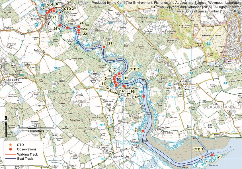
the locations of these observations are shown in Figure I.1.
I.1. Fishery
Currently all of the Beaulieu River production area is closed to harvesting. The whole of the
Beaulieu is a private fishery with the current rights for the harvesting of manila clams and
native oysters belonging to David Mitchell. In the northern section of the Beaulieu, between
Bailey’s Hard and north east of Buckler’s Hard the classification zone for manila clams is
prohibited due to high E. coli results. Illegal harvesting of manila clams has been reported
by the harvester since the area has become prohibited. The harvester expressed an interest
in moving the classification zone for manila clams further down the estuary to see if better
hygiene results were observed.
Beaulieu River Sanitary Survey Review 2015 – Appendices 36Native oysters were classified in the Beaulieu south of Buckler’s Hard until 2011. Declassification occurred due to a lack of commercially available stock. The harvester expressed an interest in undertaking a survey to establish the current distribution of native oysters in the lower Beaulieu and getting the area reclassified. I.2. Sources of contamination Sewage discharges The location of Bucklers Hard STW and Bucklers Hard STW outfall were confirmed and the outfall effluent gave an E. coli concentration of 33,000 cfu/100 ml. Beaulieu Village WwTW continuous and intermittent discharge (26) locations were confirmed, however the pipes were submerged at the time of the survey. Spearbed Copse private discharge (21) was located but also submerged. It was therefore difficult to assess whether these discharges were pumping at the time of survey and if so obtain a sample. A possible septic tank (22) was sighted close to a property on the north eastern shore of the Beaulieu which is not on the EA consents database. No associated pipe was observed. Freshwater inputs Small stream inputs were observed at several locations throughout the Beaulieu (5, 15, 19, 24 & 25). For most of these, E. coli concentrations ranged between 150 and 800 cfu/100 ml. Observation 5 had relatively high E. coli loadings of 4.45x10¹⁰ cfu/day. A sluice in Beaulieu village through which the Beaulieu River drains to the Beaulieu estuary (observation 1), and therefore represents all sources above the tidal limit, had a high E. coli concentration of 4,000 cfu/100 ml. Several pipes that were not listed in the EA consents database were observed in the Beaulieu. It is therefore assumed that these are either surface or ground water drainage (2, 3, 4, 11, 12, 13, 16 &17). At the time of survey six were flowing but only two were sampled as the flow was too small to measure at observation 3, 11, 16 and 17. E. coli results of those sampled gave E. coli results between 50 and 1,000 cfu/100 ml (4 & 12). Surface water samples were taken at two locations within the Beaulieu, in the upper (CTD 2, 630 cfu/100 ml) and mid estuary (CTD 3, 140 cfu/100 ml). Samples are referred to as CTD samples as conductivity, temperature and depth measurements were taken at the same location and time as water samples. Livestock No livestock was observed on the shoreline survey. Wildlife Birds were observed throughout the survey area (7, 10, 18, 20, 23 & 27). Beaulieu River Sanitary Survey Review 2015 – Appendices 37
Figure I.1: Locations of shoreline observations (see Table I.1 for details).

Beaulieu River Sanitary Survey Review 2015 – Appendices                                              38
Table I.1: Details of Shoreline Observations
Observation
no. NGR Date Time Description Photo
1 SU3873402311 23/02/2015 09:00 Sample from above sluice gate, B01 Figure I.6
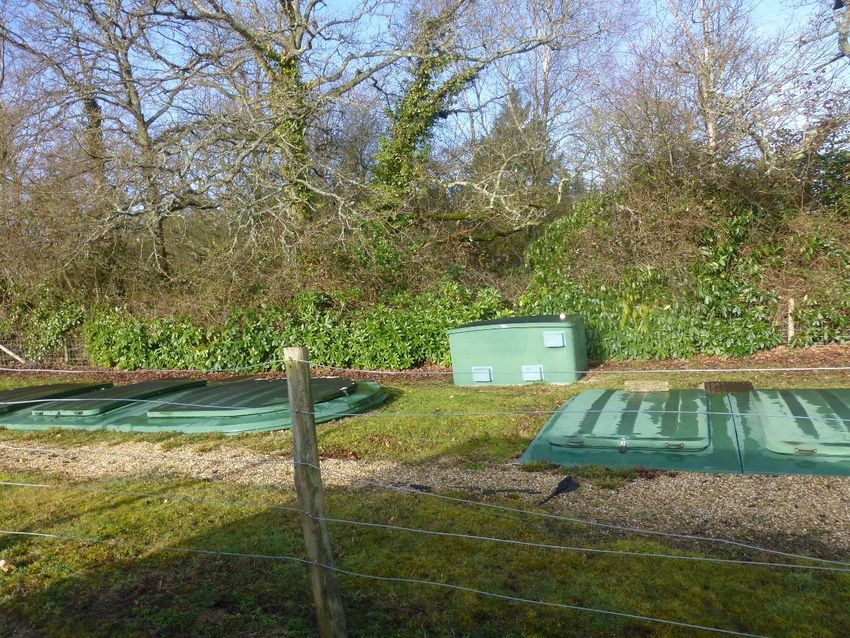
2 SU3879002327 23/02/2015 09:04 Pipe submerged Figure I.7
3 SU3880302347 23/02/2015 09:06 Surface drainage pipe, dripping Figure I.8
Pipe with flat valve, flowing (0.17m x 0.02m x
4 SU3887202398 23/02/2015 09:07 0.184m/s), B02 Figure I.9
Stream and pipe, flowing (1.15m x 0.3m x
5 SU3893502436 23/02/2015 09:12 0.711m/s), B03 Figure I.10
6 SU4077200162 23/02/2015 09:39 Bucklers Hard STW Figure I.11
7 SU4087000519 23/02/2015 10:50 ~30 ducks on the river
8 SU4076600469 23/02/2015 10:51 Marsh drainage channel
9 SU4074200423 23/02/2015 10:52 Marsh drainage channel
10 SU4073000387 23/02/2015 10:52 ~ 20 ducks
11 SU4072600357 23/02/2015 10:53 Pipe with flat valve, trickling Figure I.12
Pipe with flat valve, flowing (0.52m x 0.07m x
12 SU4081600226 23/02/2015 11:00 0.200m/s), B04
13 SU4074100285 23/02/2015 11:01 Pipe, flowing (0.09m x 0.03m x 0.384 m/s), B05 Figure I.13
Bucklers Hard STW outfall (0.43m x 0.01m x
14 SU4078900203 23/02/2015 11:08 0.058m/s), B06
15 SU4077700194 23/02/2015 11:09 Culverted stream, flowing
16 SU4104300159 23/02/2015 11:30 Pipe, dribbling
17 SU4101500146 23/02/2015 11:32 Pipe in quay, dribbling
18 SZ4159899850 23/02/2015 11:40 ~ 30 ducks
19 SZ4157098832 23/02/2015 12:11 Stream, flowing, B07
20 SZ4361698122 23/02/2015 13:30 ~ 40 gulls
21 SU4042201299 23/02/2015 13:30 Spearbed Copse Private discharge submerged Figure I.14
22 SU3967801738 23/02/2015 13:41 Possible septic tank
23 SU3967301795 23/02/2015 13:43 ~ 30 gulls
24 SU3967601901 23/02/2015 13:45 Unnamed stream culverted, flowing, B08
25 SU3934601870 23/02/2015 13:52 Submerged culvert Figure I.15
Beaulieu Village WwTW continuous and
26 SU3911601939 23/02/2015 13:55 intermittent discharge
27 SU3894502361 23/02/2015 14:03 ~40 gulls
CTD 1 SZ4332998071 23/02/2015 12:27 CTD measurement
CTD 2 SU4089500447 23/02/2015 14:00 CTD measurement and water sample
CTD 3 SU3911002302 23/02/2015 14:29 CTD measurement and water sample
Beaulieu River Sanitary Survey Review 2015 – Appendices 39Figure I.2: Water sample results (Table I.2 for details). Beaulieu River Sanitary Survey Review 2015 – Appendices 40
Table I.2: Water sample E. coli results, spot flow gauging results and estimated loadings.
                                                                                                              E. coli
             Observation                                                                              concentration    E. coli loading
 Sample ID    number        Date and time Description                                  Flow (m/s)       (cfu/100 ml)      (cfu/day)          NGR
    B01           1        23/02/2015 09:00   Sample from above sluice gate   Too large to measure            4,000           -          SU3873402311
                                                                                                                                  8
    B02           4        23/02/2015 09:08   Pipe with flat valve                           0.001              230       1.24x10        SU3887202398
    B03           5        23/02/2015 09:12   Stream and pipe                                0.245              210       4.45x10¹⁰      SU3893502436
    B04          12        23/02/2015 11:00   Pipe with flat valve                           0.007              963       6.06x10⁹       SU4081600226
    B05          13        23/02/2015 11:02   Pipe                                           0.001               50       4.48x10⁷       SU4074100285
    B06          14        23/02/2015 11:09   Bucklers Hard STW Outfall
I.3. Conductivity, temperature and depth (CTD)
measurements
Conductivity on the practical salinity scale (PSS), temperature in °C and depth in metres
[CTD] measurements were taken at three locations within the Beaulieu River shown in
Figure I.1. Temperature and salinity profiles for these locations are shown in Figure I.3 to
Figure I.5.
CTD measurements were taken in the upper, middle and lower Beaulieu estuary. CTD 1
was taken 1.5 hours before high water and CTD 2 and 3 measurements were taken on the
ebb tide. In the lower estuary CTD 1 the salinity and temperature measurements were fairly
constant (31.5 – 32.4 PSS and 6.3°C) throughout the water column showing that there is
limited variation in salinity and therefore minimal freshwater inputs.
In the upper estuary (CTD 2) there was a large freshwater influence, as demonstrated by
the salinity ranges recorded, from 0 PSS at the surface increasing to 7.7 PSS at 2.9 metres.
The temperature is fairly constant between 5.9 and 6.1 °C.
In the mid estuary (CTD 3) there is incomplete mixing with lower salinities being recorded in
the surface waters and higher salinities at depth.
Lower Estuary Lower Estuary
Temperature (°C) Salinity (PSS)
5.5 5.7 5.9 6.1 6.3 6.5 0 5 10 15 20 25 30 35
0 0
1 1
2 2
3 3
Depth (m)
4 4
5 5
6 6
7 7
Figure I.3 CTD 1
Beaulieu River Sanitary Survey Review 2015 – Appendices 42Upper Estuary Upper Estuary
Temperature (°C) Salinity (PSS)
5.5 5.7 5.9 6.1 6.3 6.5 0 5 10 15 20 25 30 35
0 0
1 1
2 2
3 3
Depth (m)
4 4
5 5
6 6
7 7
Figure I.4 CTD 2
Mid Estuary Mid Estuary
Temperature (°C) Salinity (PSS)
5.5 5.7 5.9 6.1 6.3 6.5 0 5 10 15 20 25 30 35
0 0
1 1
Depth (m)
2 2
3 3
4 4
5 5
6 6
7 7
Figure I.5 CTD 3
Beaulieu River Sanitary Survey Review 2015 – Appendices 43Figure I.6
Figure I.7
Beaulieu River Sanitary Survey Review 2015 – Appendices 44Figure I.8
Figure I.9
Beaulieu River Sanitary Survey Review 2015 – Appendices 45Figure I.10
Figure I.11
Beaulieu River Sanitary Survey Review 2015 – Appendices 46Figure I.12
Figure I.13
Beaulieu River Sanitary Survey Review 2015 – Appendices 47Figure I.14
Figure I.15
Beaulieu River Sanitary Survey Review 2015 – Appendices 48Appendix II. Beaulieu River Sanitary Survey
Report 2009
Beaulieu River Sanitary Survey Review 2015 – Appendices 49You can also read