Maigue River Catchment Characterisation - Maigue Rivers Trust
←
→
Page content transcription
If your browser does not render page correctly, please read the page content below
Maigue River Catchment
Characterisation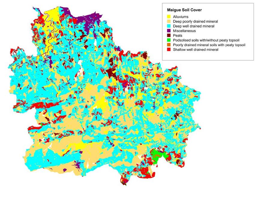
Maigue River Catchment Characterisation

Authors: Catherine Dalton1&2 and Niall Walsh1
1
  Mary Immaculate College
2
  Maigue Rivers Trust

Table of Contents

Maigue River Catchment Characterisation ............................................................................................. 1
1. Physical setting.................................................................................................................................... 2
2. Geology & Topography ....................................................................................................................... 2
3. Soils & Subsoils.................................................................................................................................... 4
4. Hydrogeology ...................................................................................................................................... 4
5. Landcover ............................................................................................................................................ 5
6. Protected Areas .................................................................................................................................. 6
7. Maigue Catchment Surface Waters .................................................................................................... 8
   7.1 Hydrology & Groundwater............................................................................................................ 9
   7.2 Aquatic Ecology

   7.3 Water Quality

8. Pressures ........................................................................................................................................... 13
9. Sub-catchments of the Maigue ......................................................................................................... 14
   Loobagh River Catchment ................................................................................................................. 14
   Morningstar River Catchment........................................................................................................... 15
   Drumcomoge/Comoge River Catchment .......................................................................................... 16
   Maigue Main River Catchment ......................................................................................................... 17
   Clonshire/Grenagh River Catchment ................................................................................................ 18
   Barnkyle River Catchment................................................................................................................. 19
Bibliography ......................................................................................................................................... 21

                                                                                                                                                         1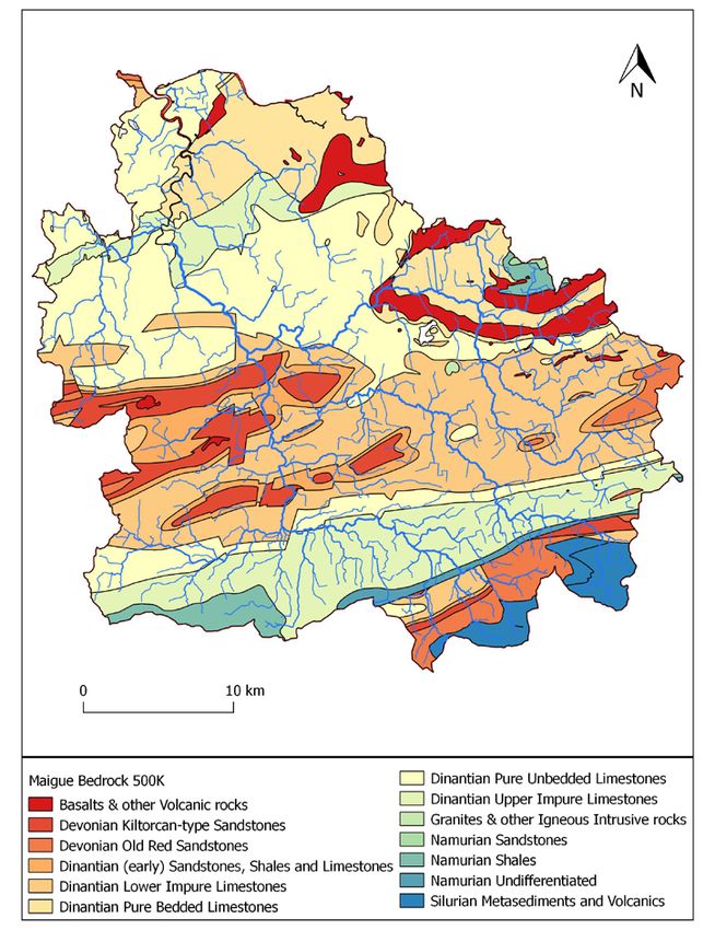
1. Physical setting

The Maigue River An Mháigh, meaning ‘river of the plain’ rises in north County Cork, and
drains in a northwest direction through County Limerick into the Shannon estuary. The
majority of the catchment is in Limerick with just 4.7% percent in north Cork and 4.4% in
east Tipperary. The catchment is part of Environment Protection Agency (EPA) water
management unit Shannon Estuary South and the Office of Public Works (OPW) hydrometric
area no. 24, which also comprises the catchments of the rivers Deel and Feale. The Maigue
catchment has a land area of 1122km2 and encompasses 1296.7km of river channel (Figure
1). The Maigue has six subcatchments including the Loobagh, Morningstar,
Drumcomogue/Comoge, Clonshire/Grenagh, Barnkyle as well as the Maigue itself (Figure 1).

Figure 1: Location of Maigue catchment with river network and towns.

2. Geology & Topography

The bedrock geology of Co. Limerick comprises primarily sedimentary (limestones,
sandstones and shales) with some igneous (basalt) rocks (Figure 2). Carboniferous limestone
underlies most of the Maigue catchment area while volcanic basalt bedrock occurs within
the limestone in the area northeast of Bruff and around Herbertstown. Sandstone bedrock
predominates in the southwest of the catchment. The erosional and depositional effects of

                                                                                         2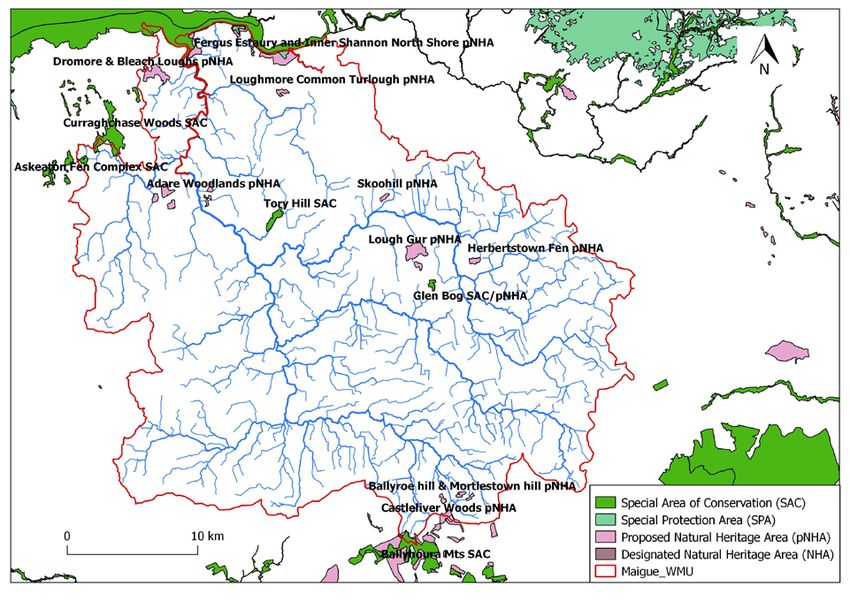
the last glaciation have largely modified the landscape generating a low relief topography
known geologically as the Limerick Basin (Finch & Ryan 1966). Most of the undulating lands
lie less than 75 m above sea level surrounded by a rim of hills. The highest point in the
catchment is Seefin Mountain at 528m and from here the catchment slopes in a northwards
direction. The Maigue, Deel and Feale rivers drain this central Limerick low-lying basin or
plain. The basin is surrounded to the south west by the Mullaghareirk Mountains, to the
south east by the Ballyhoura Hills and Galty Mountains and to the east/north-east by the
Slievefelim, Arra and Slieve Bernagh mountains. The low lying plain topography has just two
east-west trending ranges of hills (>200m) near Ballingarry in Co. Limerick in the west of the
catchment.

Figure 2: Bedrock geology of the Maigue catchment.

                                                                                            3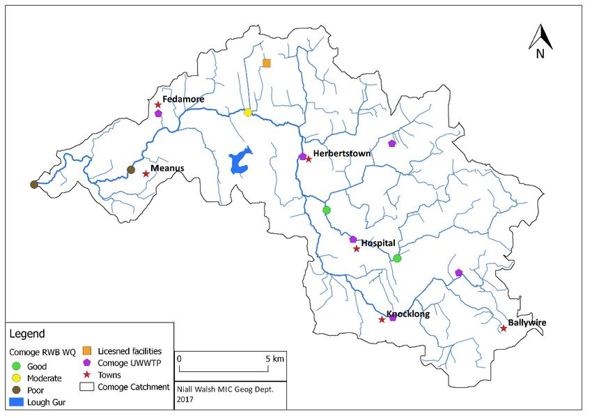
3. Soils & Subsoils

The catchment soils are predominantly deep well drained mineral soils in areas overlying
limestone while poorly drained soils occur in sandstone areas (Figure 3). The predominant
catchment subsoils include glacial tills. Minor peat deposits and glacial sands and gravels
occur along with extensive deposits of alluvium from river overflow are typically found along
the outer edges of river channels particularly in the region north of Adare.

Figure 3: Soils in the Maigue catchment.

4. Hydrogeology

Eight groundwater aquifer (permeable rock) categories are defined by the Geological Survey
of Ireland based on hydrogeological characteristics. The majority of the Maigue catchment
is underlain by three groundwater bodies reflecting regionally or locally important aquifers
(Figure 4) (Deakin et al. 1998). The majority of the catchment is underlain by Locally
Important Aquifer (Ll) or bedrock which is moderately productive but only in local zones.
This aquifer class is found in the Kilfinnane, Kilmallock, Bruff and Hospital regions. The
second most prominent is aquifer of Regionally Important Karstified (Rkd - d denotes diffuse

                                                                                           4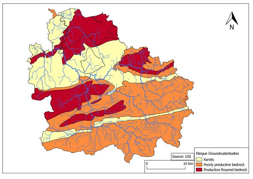
or slow groundwater flow) which incorporates areas around Rathkeale and Croom and
circumnavigates the igneous outcrop near Lough Gur. This is followed by Regionally
Important Fissured bedrock (Rf) found underlying the hills near Ballingarry and Bruree. The
region north of Adare extending from Kildimo to Foynes is underlain by a Regionally
Important Aquifer - Karstified (Rkc - c denotes conduit or faster groundwater flow). Finally,
LM is a Locally Important Aquifer, which is generally moderately productive. This aquifer
circles Lough Gur and underlies Limerick city and environs.

The groundwater in Co. Limerick and the Maigue catchment is influenced by the dominant
limestone geology and overlying glacial tills and soils and thus is hardwater in nature
(classed as calcium bicarbonate Ca(HCO3)2). Groundwater quality problems result from the
permeable nature of the fissured and karstic aquifers and human activities, which result in
nutrient inputs and faecal contamination (Deakin et al. 1998).

Figure 4: Groundwater bodies of the Maigue catchment.

5. Landcover

Military reports from the Maigue region in the 1600s describe “Woods stretched eastwards
from Rathkeale to link up with the long tract of forest that lay between Charleville and
Kilmallock in the south of county Limerick and reached the Shannon at Pallaskenry…
while…Northwards of Croom there were intermittent woods and bogs to Limerick
(McCracken (1959: p. 279). A very changed landscape today is evident in the Maigue
catchment with land cover derived using CORINE 2012 Landcover data (Table 1; Figure 2).

                                                                                           5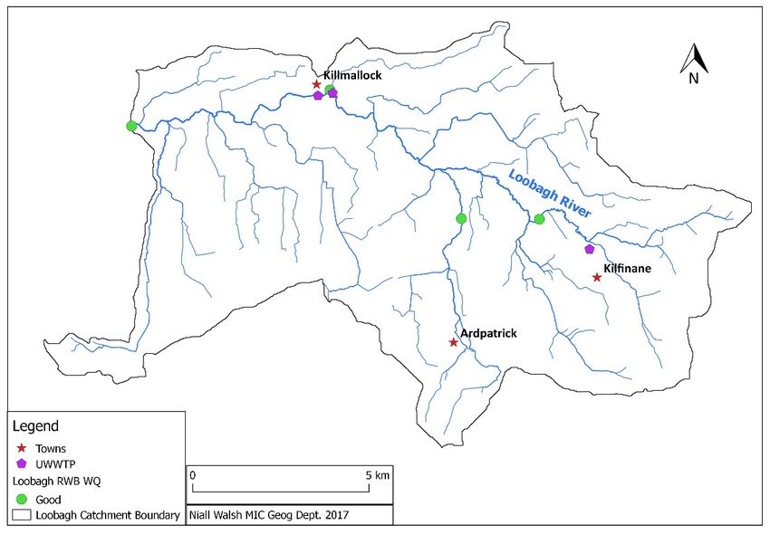
Agriculture is the dominant land use in the catchment with pasture farming the main
activity (82%). Artificial surfaces principally residential and industrial, are the next highest at
6.4% while forest, semi-natural areas, wetlands and waterbodies comprise just 8% of the
catchment area.

Table 1: Summary table of CORINE landcover in the Maigue catchment (2012).
       CORINE land type Level 1       Km²           % Catchment
       Artificial surfaces            71.87         6.4
       Agricultural Areas             963.42        85.83
       Forest and semi natural areas  48.37         4.31
       Wetlands                       24.57         2.19
       Water Bodies                   14.29         1.27
       Total                          1122.53       100

The Maigue catchment is a predominantly rural area. The main urban centres within the
catchment area are Charleville (population 3919: 2016 census) located on the Charleville
Stream, Kilmallock (population 1668) situated on the upper reaches of the River Loobagh,
and Croom (population 1159) and Adare (population 1129) located on the main Maigue
channel in its middle and lower reaches.

6. Protected Areas

The Maigue catchment has six Special Areas of Conservation (SACs) which include priority
(Annex 1) habitats designated under the EU Habitats Directive (Table 3; Figure 5). These
include Curraghchase Woods, Tory Hill, Glen Bog, Ballyhoura Mountains, Lower River
Shannon and the Askeaton Fen Complex. Additionally the River Shannon Estuary in receipt
of Maigue inflow waters is designated as a Special Protection Area (SPA) while Ballyhoura
Mountains are also a designated National Heritage Area (NHA).

Table 2: Protected areas in the Maigue Catchment

  Site Name                 Status        Area(ha)     Conservation Priority
  Curraghchase Woods        SAC           358.21       Alluvial forests, Yew woodland, Lesser
                                                       Horseshoe Bat
  Tory Hill                 SAC                        Orchid-rich Calcareous Grassland,
                                                       Cladium Fens, Alkaline Fens
  Glen Bog             SAC                28.49        Alluvial Forests
  Ballyhoura Mountains SAC, NHA                        Complex of heath (wet and dry), and
                                                       active blanket bog with relict oak
                                                       stands.
  Lower River Shannon       SAC, SPA                   Large estuarine and wetland complex.
                                                       Of international importance for
                                                       wintering and migrating waterfowl.

                                                                                                 6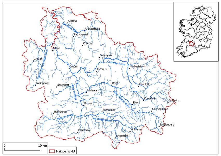
Askeaton Fen            SAC          284.77      Calcareous (Cladium) and alkaline fens
  Complex

Other notable proposed natural heritage areas (pNHAs) in the catchment area include: 1.
Loughmore Common turlough a habitat located southeast of Mungret and about 3km from
the Shannon Estuary known for its wintering birds. The habitat originally measured some
30ha and has been much modified by drainage and some tree planting; 2. Herbertstown Fen
on Stramus Island, located 2km northeast of Foynes, is a large wet fen of good botanical and
ecological interest; 3. Adare woodlands are composed of dry, broadleaved woodlands,
believed to be amongst the oldest in the country; 4. Two woodlands found at Skoolhill have
a mixture of native tree species such as ash, hazel, hawthorn and oak as well as exotics like
beech and sycamore. This site is the only known location in Ireland of the grass Festuca
heterophylla; 5. Bleach and Dromore Loughs are almost entirely groundwater fed and are
surrounded by alkaline fens; 6. Graigue Wood is a 29 ha Coillte owned native drumlin and
lakeside woodland 1 km southwest of Adare. It has been clear felled in the past and is now
dominated by a relatively young population of tall ash trees; and 7. Lough Gur is
groundwater fed lake perched above the water table. Gur is also Limerick’s largest lake and
is situated in an internationally important archaeological landscape and consequently is an
important asset to the county historically, aesthetically and economically.

                                                                                            7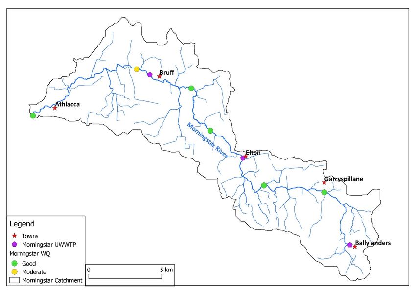
Figure 5: Special Areas of Conservation and proposed Natural Heritage Areas in the Maigue
catchment.

7. Maigue Catchment Surface Waters
The Maigue drains the limestone lowlands northwards to the Shannon estuary and forms a
branching (dendritic) pattern. The upper river reaches (Loobagh, Upper Maigue,
Morningstar) rise in the Ballyhoura Mountains which reach altitudes of 528 m OD. The
Maigue river catchment has six key subcatchment areas, the Comoge, Clonshire/Grenagh,
Loobagh, Morningstar, the Maigue itself and the Barnkyle which rises near Crecora and
drains into the tidal River Maigue (Figure 1). The catchment rivers encompass six stream
orders - a method for identifying and classifying types of streams based on their numbers of
tributaries. 77% of the Maigue catchment rivers are 1st order streams, 11% are 2nd order
while 5.5%, 3.2%, 1.3% and 1% are 3rd, 4th, 5th and 6th orders respectively. First order
streams therefore have a profound influence in the Maigue catchment and land use
adjacent to these small headwater streams would have a disproportionately large impact on
on shaping downstream water quantity and water quality. The higher the stream order, the
more streams that feed into it and the larger the size of the stream. Higher stream orders
are more likely to be influenced by events occurring higher upstream.

Turloughs are temporary ponds or lakes found overlying karstified Carboniferous limestone.
Most turloughs are found in Counties Galway, Mayo and Clare but some feature also in the
karstic areas of the Maigue catchment (Reynolds 2014). These include Lough Selleher and

                                                                                          8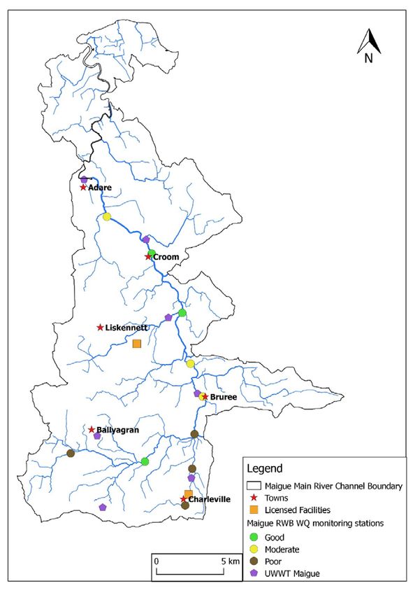
Graigues Lough, both in the northern limestone area of the county on private property, and
Loughmore Common, near Limerick City.

7.1 Hydrology & Groundwater

Hydrometric gauges
River water levels and water flow are measured by the OPW along the Maigue river and its
tributaries at 27 hydrometric stations along 11 different waterbodies (Table 3). Sixteen
station gauges are active and 12 inactive (with graduated staff guages only) while thirteen
are automated transmitting data in real time (http://waterlevel.ie/hydro-data/home.html).
Eight stations record flow, 12 record waterlevel and flow, and 6 record water level only.
Principal tributaries including the Morningstar (140km2) had a mean annual flow of 2.3m3/s
and a dry weather flow of 0.11m3/s, the Maigue catchment (240km2 at Bruree) had a mean
annual flow 4.6m3/s, while the catchment area downstream at Croom (estimated to be
774km2) had a mean annual flow of 12.8m3/s and a dry-weather flow of 1.3m3/s (ARUP
2008).
Water abstraction

There are two municipal water treatment plants in Adare and Kilmallock, and which derive
their water from the Maigue and Loobagh respectively. Pallaskenry/Kildimo used to be
supplied from Bleach Lough, but was decommissioned a few years ago and the area is now
supplied by the Shannon Estuary Scheme which takes water from the River Deel.
Additionally there are 123 public and private group water schemes in Co. Limerick, of which
almost 80% are from groundwater supplies (Deakin et al. 1998). Source protection schemes
are in place in Bruff, Fedamore, Croom, Herbertstown, Hospital, Ballingarry, Mortlestown,
and Ballynagran.

Table 3: OPW Hydrometric Stations Maigue Catchment

                                             Guaged
 Station                                     Catchment Area    Hydrometric       Data
 No.       Station Name       Waterbody      km2               Available
 24001     Croom              Maigue         770.2             Water Level and Flow
 24002     Gray's Br.         Camoge         243.6             Water Level and Flow
 24003     Garroose           Loobagh        129.2             Water Level and Flow
 24004     Bruree             Maigue         242.1             Water Level and Flow
 24005     Athlacca           Morningstar    131.9             Water Level and Flow
 24006     Creggane           Maigue         83.1              Water Level and Flow
 24007     Caherass           Maigue         798.2             Flow Measurements
 24008     Castleroberts      Maigue         806.0             Water Level and Flow
 24009     Adare Manor        Maigue         839.4             Water Level Only

                                                                                         9
24016 Kilmallock Loobagh 80.6 Water Level and Flow
24022 Hospital Mahore 41.2 Water Level and Flow
24023 Knocklong Drumcamoge 39.2 Water Level and Flow
24024 Garryspillane Morningstar 18.6 Flow Measurements
24025 Bruff Morningstar 91.5 Flow Measurements
24026 Kilfinnane Loobagh 5.9 Flow Measurements
24027 Doorlus Maigue Trib. 19.1 Flow Measurements
24028 Ballynabanoge Maigue Trib. 30.1 Flow Measurements
24034 Riversfield Weir Loobagh 54.6 Water Level and Flow
24039 Ballylanders Morningstar 5.6 Flow Measurements
24044 Rylanes Clonshire 6.3 Flow Measurements
24061 Ferry Br. Maigue Est. 983.5 Water Level Only
24062 Adare Quay Maigue Est. 844.7 Water Level Only
24067 Normoyle's Br. Greanagh 83.6 Water Level Only
24081 Currachase Currachase 0.5 Water Level Only
24082 Islandmore Maigue 762.8 Water Level and Flow
24083 Tooreen Camoge 264.8 Water Level Only
Kilmallock
24084 Creamery Maigue 76.3
7.2 Aquatic Ecology
Flora
The Maigue catchment supports a diverse range of both aquatic and terrestrial flora.
Aquatic flora can be found in river and streams around the catchment and also in Lough
Gur. Instream vegetation includes Caltriche sp., water crowfoot Ranunculus sp., emergent
Branched Bur-reed (Sparganium erectum), river moss Fontinalis sp. and fool’s watercress
Apium nodiflorum. Bankside vegetation includes yellow iris Iris pseudacorus, nettle Urtica
dioica and bramble Rubus sp.. Triangular club-rush (Schoenoplectus triqueter), a species of
brackish mud in estuaries and tidal rivers, is found only in the upper part of the Shannon
Estuary below Limerick City at the confluence of the River Maigue.
Riparian zone scrub and woodland vegetation includes White Willow (Salix alba), Grey
Willow (Salix cinerea), mature Ash (Fraxinus excelsior) with an understorey of Hawthorn
(Craetagus monogyna) and Elder (Sambucus nigra) and Alder (Alnus glutinosa).
Fauna
The Maigue catchment and its tributaries have records of protected aquatic species
including the salmon, lamprey, white- clawed crayfish, otter. Details on fish are outlined in
‘Fish stocks in the River Maigue Catchment’. Three-spined stickleback Gasterosteous
aculeatus are abundant in the Maigue and its tributaries. The white-clawed crayfish
10(Austropotamobius pallipes) is legally protected under Annex II and V of the EU Habitats
Directive.
Typical mammalian fauna are present in this rural agricultural catchment including species
protected under the Wildlife Acts; Badger (Meles meles), Bat species, Hare (Lepus timidus
hibericus), Otter (Lutra lutra), Stoat (Mustela erminea) and Hedgehog (Erinaceus
europaeus). Others such as Wood Mouse (Apodemus sylvaticus), Pygmy Shrew (Sorex
minutus), Brown Rat (Rattus norvegicus), Fox (Vulpes vulpes) and Rabbit (Oryctolagus
cuniculus) are also likely to be present. Additionally Annex II bat species, Lesser Horseshoe
Bat use the river as a feeding habitat while otter can be found along the whole of the river
and also in the saltwater of the estuary, feeding on eels, salmonids and crayfish.
7.3 Water Quality
Waterbodies in the Maigue catchment are monitored four times per year by the EPA as part
of a national operational monitoring programme. Limerick City and County Council have
historically and continue to provide investigative river monitoring. Each river is assigned an
overall status based quality elements including general physico-chemical elements,
hydromorphology, fish, macroinvertebrates, macrophytes (plants) and diatoms (algae). The
classification scheme for water quality includes five classes: high, good, moderate, poor and
bad. Three cycles of assessment have been undertake in recent years 2007-2009, 2010-2012
and 2010-2015 (Table 4). Assessments carried out between 2007 and 2009 characterized
the rivers of the Maigue catchment as follows: 0 bad, 15% poor, 25% moderate, 26% good
status with 34% of the catchment unassigned. The second cycle of the WFD (2010-2012)
aimed to collect more accurate data and separated river water bodies into segments and
saw revised classifications with increases in poor quality status (19%), declines in moderate
(18%), and increases in the good category (29%). The most recent EPA assessments (2010-
2015) saw no change in the poor category (19%), declines in Moderate (17%), and increases
again in terms of good water quality (31%) representing 1153 km of water channel.
A ‘Pressure and Impact Assessment’ was undertaken on Maigue catchment water bodies for
the period between 2010-2015 (Table 5). This assessment reviews the impact of human
activity on surface waters and ground waters and identifies water bodies that are at risk of
failing to meet the EU Water Framework Directive's environmental objectives. Therefore,
‘At Risk' means that the Pressure and Impact assessment shows that there is a likelihood
that a water body will fail to meet the Directive's environmental objectives unless
appropriate management action is taken. Exactly half (50%) of the Maigue river water
bodies were ‘At risk’, with approximately a quarter ‘Not at Risk’ (22%). A further quarter of
the water bodies need to be reviewed (24%), while a small number remained unassigned
(4%). Additionally a characterization tool has been developed to produce Pollution Impact
Potential (PIP) maps that show the potential critical source areas for agricultural diffuse
nutrients in water bodies and rank the relative risk areas. The PIP maps combine soil
11drainage characteristics and bovine stocking rate to determine the risk of nutrient loss to
surface and groundwaters.
The Maigue river estuary has been classed as ‘moderate’ quality throughout each of these
assessment cycles. The estuary generally exhibits high nutrient concentrations and thus has
an intermediate trophic classification and is classified as ‘At risk’.
Lough Gur, the only significant lake in the Maigue catchment, has had a range of water
quality problems over the years. It has been described as a eutrophic and hypereutrophic
lake with unsightly algal blooms in a series of studies (King and O’Grady, 1994; Ball, 2004;
McGarrigle et al. 2010). In the most recent EPA monitoring programme 2012-15 Lough Gur
was classified with ‘poor’ water quality and ‘at risk’.
Table 4: WFD Pressure and Impact assessments of river water bodies percentage of channel
length (km) in each risk category in 2010-2015 in the Maigue catchment.
Not at Length
River Sub Basin At risk Risk Review Unassigned (Km)
Greanagh 84.4 37.0 3.2 124.7
Ballynaclogh 122.0 24.5 146.5
Drumcomoge (1) 76.9 76.9
Drumcomoge (2) 72.7 34.3 40.8 147.8
Maigue (1) 54.3 43.9 98.2
Maigue (2) 45.0 67.9 67.1 179.9
Maigue (3) 68.9 27.5 41.6 138.0
Maigue (4) 51.1 43.1 47.7 141.9
Maigue (5) 74.8 15.6 57.2 147.6
Morningstar 95.2 95.2
Total (km) 650.2 283.6 315.8 47.1 1296.7
% 50 22 24 4 100
Invertebrate surveys of the river Maigue and its tributaries have been carried out by the EPA
on a continuous basis at approximately 30 sites every three years since 1971. A macro-
invertebrate survey of 33 sites in the Maigue catchment in 2012 derived quality (Q) values
and estimated 45% with good Q4 status, 18% moderate, 33% poor and 3% with bad status
(EPA 2012). Sensitive species such as Stonefly and Mayfly (e.g. Ephemera) larvae are found
in cleaner tributaries and are absent from polluted rivers where more tolerant species such
as blood worms and leaches are found (Table 6). The most recent round of monitoring
covered the period 2013 to 2015 saw a decline in quality when most of the catchment was
given a Q3-4 and Q3 rating, which means that is slightly or moderately polluted in most
areas.
12Table 5: Invertebrates and biological classification of river quality (EPA).
Most tolerant Very Tolerant
Pollution Less Sensitive Sensitive
Tolerant
Tubificidae Asellidae Gammaridae Leuctridae Plecoptera
Chironomus sp. Crangonyx sp. (excl. Cased Caddis, (excl.
Eristalis sp. Physa sp. Crangonyx sp.) Ancylidae Leuctridae.)
Sphaeriidae Gastropoda Heptageniidae
(excl. Ancylidae, Ameletus sp.
Physa sp.) M.
Simuliidae margaritifera
Uncased Caddis
Chironomidae
(excl.
Chironomus sp.)
8. Pressures
Channel modifications
Land reclamation and river modifications around the Shannon Estuary are thought to have
commenced as early as 1100 AD with small scale works in place by the 1300s (Healy &
Hickey 2002). The Down Survey Maps suggests that the Shannon estuary had experienced
some reclamation by the mid-1600s. The development of inland navigation began in Ireland
in 1715, with the improvement of the Maigue River. Government-led reclamation schemes
began in the early 1800s, with the first known survey in 1822 and the first Shannon
Navigation Act in 1834. Three main areas were targeted for reclamation, the Fergus in Clare,
Limerick on the Shannon and the Maigue River. In the Maigue catchment some 2000
hectares, extending 10 kilometres inland from the estuary were reclaimed through
embankments and drainage works from the mid-1800s onwards.
More recently the river was subject to major arterial drainage in the 1970 and 1980s,
including channel-straightening works, affecting some 30,500 acres. Additionally The OPW
installed 10 concrete weirs as part of an effort to enhance fisheries and restore angling
pools on the Lower River Maigue. Remnants of these works are evident in the river channel
today with canalisation, culverting, gabions, weirs and embankments (levees) all present.
Pollution
Pressures identified for the Maigue catchment in the 1st cycle of the River Basin plans
(DCELG, 2012) included diffuse pollutant sources from agricultural activities, and onsite
septic tank systems, as well as point sources including wastewater treatment plant and
industrial discharges, quarries mines and landfills. In 2008 it was estimated that 61% of
13nutrient inputs (in the form of total phosphorus) came mainly from agriculure (52%) and
sewage waste (12%). Point pressures in the catchment include 23 wastewater treatment
plants, three waste facilities, 4 IPPC licened facilities, three Section-4 operations and three
drinking water treatment plants. The catchment additionally has nine quarries and 13
landfills. A total of 15,300 septic tanks were enumerated with almost 5500 located in areas
vulnerable to runoff contamination (DCELG, 2012).
9. Sub-catchments of the Maigue
Loobagh River Catchment
The source of the River Loobagh is in the Ballyhoura Mountains specifically Keale Mountain
at approximately 240m. From here the river flows north west through Kilfinane, Balinanima
and Kilmallock before joining the Maigue River south of Bruree (Figure 6). The river has a
total catchment area of 129.6km2 and 172.6km of river channel with three tributaries
entering the river downstream. The Flemingstown tributary flows through Ardpatrick before
it joins the Loobagh downstream after Balinanima and has retained a good water quality
since 2007. The Fairyfield Glebe tributary joins the Loobagh just before Fairyfield. This
tributary has had poor and moderate water quality since 2010. The Ballysallagh tributary
joins the Loobagh downstream of Kilmallock before it connects with the Maigue River. This
stream has moderate water quality. Four monitoring sites along the Loobaghs main river
channel indicate the river currently has good water quality following a pollution incident just
up-stream of Kilmallock in August 2014. The proportion of high Pollution Impact Potential
(PIP) areas is low in the upper section but becomes high further downstream due to an
increase in the proportion of poorly drained soils .
14Figure 6: Loobagh river catchment.
Morningstar River Catchment
The source of the Morningstar River is in the Ballyhoura Mountains at approximately 200m.
From here the river flows north west through Ballylanders, Garryspilanne, Elton and Bruff
after which it alters course to flow west and south west through Athlacca before joining the
Maigue (Figure 7). The catchment covers an area of 135.5km2 and has 165.2km of river
channel with one main tributary Goat Island stream which flows into the Morningstar after
Banogue. The Morning star has good water quality in its upper reaches from Garryspilanne
to Banogue. Moderate water quality is recorded down stream of Bruff before returning to
good water quality before Athlacca. Goat Island tributary which is reported to have
Extensive Moderate PIP joins the Morningstar between Banogue and Bruff (no Q value
reported). From Banogue to Athlacca extensive areas of moderate PIP are reported due to
the nature of the soils.
15Figure 7: Morningstar river catchment.
Drumcomoge/Comoge River Catchment
The source of the Drumcamoge River which subsequently becomes the Camoge River is in
Ballywire on the border of Co. Limerick and Co. Tipperary at 160m (Figure 8). The
Drumcomoge/Camoge catchment covers an area of 265.1km2 and has 284.9km of river
channel. From Ballywire the river flows north west into Co. Limerick through Knocklong,
Ballyclough and Knockaing. Upstream of Knockainy two tributaries the Mahore and
Ballyamona join together before joining Drumcamoge which subsequently becomes the
Camoge River. The Camoge River then flows north through Herbertstown after this it alters
course west and then south west arching around to the north of Lough Gur Lake.
Ballycullane tributary joins the Camoge River before Meanus and then joins the Maigue
downstream of Meanus. The Drumcomoge River has 20.4km of river channel with no
operational monitoring site therefore water quality status is unassigned. The Mahore
tributary has two operational monitoring sites along its course which reported good water
quality in 2015. Ballynamona tributary is at risk of pollution from agricultural activities and
arterial drainage, however no water quality status assigned. Water quality in the Camoge
River downstream of Herbertstown is moderate with high PIP coming from agricultural
activities. The both the surface and subsurface outflows from Lough Gur flow in to the
Ballycullane tributary. The Ballycullane has areas of high PIP due to a high proportion of
poorly drained soils. Water quality at Meanus is poor. Downstream of Meanus the water
quality is also poor.
16Figure 8: Camoge river catchment.
Maigue Main River Catchment
The source of the Maigue River occurs along the border between Co. Cork and Co. Limerick
south west of Ballyagran at 200m (Figure 9). The catchment covers a total area of 362.4km2
and has 336.7km of river channel. Initially the headwaters have poor water quality but then
turn to good water quality as it flows east. Charleville stream, which has poor water quality,
joins the Maigue to the north of Charleville. The Loobagh River then joins the Maigue south
of Bruree. The river flows north through Bruree where the water quality turns to moderate.
North of Bruree, Ballyania tributary and the Morningstar River join to the Maigue. Water
quality continues to be moderate downstream and improves to good condition south of
Croom as Liskennett tributary and the Camoge River join the Maigue. Water quality
continues to be good as the Maigue flows through Croom but turns moderate south of
Adare. In total the catchment contains 7 Urban Waste Water Treatment plants and has 2
licensed industrial discharges. Significant pressures on the Maigue include a WWTP at twice
its capacity and industrial discharge from a creamery on Charleville stream. Further
downstream agriculture is the main pressure.
17Figure 9: Maigue main river channel catchment.
Clonshire/Grenagh River Catchment
The source of the Clonshire stream is just south of Ballingarry at 100m. From here the
stream flows north towards Croagh where the Grenagh stream tributary joins it (Figure 10).
North of Croagh the Clonshire flows into the Grenagh River which subsequently joins the
Maigue at Adare. The catchment covers 104.5km2 and has 70.7km of river channel. Both the
Clonshire and the Grenagh have poor water quality throughout the course of their river
channel. Point and diffuse pollutant sources are present with Ballingarry UWWTP,
agriculture activites and septic tanks.
18Figure 10: Clonshire/Grenagh river catchment.
Barnkyle River Catchment
The source of the Barnkyle River is just north of Fedamore at 100m. The river then flows
north west past Crecora, Ardnacrusha, Patrickswell before joining the Maigue estuary after
Clarina (Figure 11). The catchment covers 53.7km2 and has 17.9km of river channel. The
river has poor water quality in its upper reaches, improving to good downstream of
Patrickswell before deteriorating again to poor before it joins the Maigue near Clarina. In
the upper levels diffuse runoff from agriculture has been suggested as a possible cause of
the poor water quality. Patrickswell WWTP is pumped into Limerick city wastewater
system.
19Figure 11: Barnkyle river catchment.
Acknowledgements
This work was funded by a Temporary Research Assistance position in Mary
Immaculate College.
Bibliography
ARUP (2008) M20 Cork-Limerick Motorway Scheme: Route Corridor Selection
Report. Volume 2A pp.280
Ball, D.M., 2004. Lough Gur Hydrological Assessment. – Draft Report (Unpublished).
Deakin, J., Daly, D. and Coxon, C. (1998) County Limerick Groundwater Protection Scheme.
Report to Limerick Co. Co., Geological Survey of Ireland, 72 pp.
DECLG (2012). Department of Public Expenditure and Reform Report of the Organisational
Review Programme: Department of the Environment, Community and Local
Government. Dublin.
20DHPCLG (2017) Draft River Basin Management Plans for Ireland 2018-2021. Department of
Housing, Planning, Community and Local Government 104pp.
Fehily Timoney Gifford (2007) Cork to Limerick route pre-feasibility study report. Final
report pp.179. National Roads Authority
Finch, T.F. and Ryan P. (1966). Soils of Co. Limerick. Soil Survey Bulletin No. 16. An Foras
Taluntais pp 198.
Healy, M. and Hickey, K.R., 2002. Historic land reclamation in the intertidal wetlands of the
Shannon estuary, western Ireland. In The 7th International Coastal Symposium, ICS
2002; Northern Ireland. Coastal Education and Research Foundation (CERF).
King, J.J., O’Grady, M.F., 1994. Aspects of the limnology of Lough Gur, Co. Limerick.
McCracken, E., (1959). The woodlands of Ireland circa 1600. Irish Historical Studies, 11(44),
pp.271-296.
McGarrigle, M., Lucey, J., Ó Cinnéide, M. (Eds.), 2010. Water Quality in Ireland 2007-2009.
Reynolds, J.D., 2014. Preliminary notes on three turloughs (temporary ponds overlying
karst) in County Limerick, with comments on their vegetation and water beetle
fauna. In Biology and Environment: Proceedings of the Royal Irish Academy (Vol.
114, No. 3, pp. 265-269). Royal Irish Academy.
21You can also read