(AEM) NYS Agricultural Environmental Management - CDRPC
←
→
Page content transcription
If your browser does not render page correctly, please read the page content below
Albany County
  Soil and Water Conservation District
  PO Box 497, 24 Martin Road   Voorheesville, NY 12186
  Phone: 518-765-7923          Fax: 518-765-2490

     NYS Agricultural
Environmental Management
         (AEM)
Albany County AEM Strategic Plan
Background Information
Our Agricultural Environmental Management (AEM) Strategy has been compiled by Soil and
Water Conservation District staff with direction from an AEM working group representing the
following agencies:
Albany County Soil and Water Conservation District (SWCD)
USDA Farm Service Agency (FSA)
USDA Natural Resources Conservation Service (NRCS)
Cornell Cooperative Extension of Albany County (CCE)
Albany County Water Quality Coordinating Committee
Albany County Office of Natural Resource Conservation
Hudson River Environmental Society
Local Working Group consisting of Dairy Farmers, a Vineyard,
and a Vegetable and Hay Crop farmer
This strategy will be reviewed by this group for comment and suggestions.
This will be a dynamic strategy that will reflect changes in goals and methods of achieving those
goals, as it is reviewed each year.
Our Mission and Vision is to protect water quality with a locally led and implemented
program which promotes coordination and teamwork, to efficiently and cost effectively
address all natural resource concerns on farms. Through the voluntary AEM process of
farm assessment, planning, implementation and evaluation we will strive to promote the
economic sustainability of farms and the agricultural community within the County while
protecting and enhancing the environment.Historical Perspective Ag NPS Abatement & Control Grant Program This grant program was established in 1994 by the State of New York to assist farmers in preventing water pollution from agricultural activities by providing technical assistance and financial incentives. County Soil & Water Conservation Districts apply for the competitive grants on behalf of farmers and coordinate funded activities. Grants can cost-share up to 75% of project costs or more if farm owners or operators contribute, in planning or implementation. Planning funds are awarded to conduct environmental planning while Implementation funds are awarded to construct or apply management practices. The New York State Soil & Water Conservation Committee and the Department of Agriculture & Markets coordinate the statewide program and allocate funds provided by the NYS Environmental Protection Fund on a semi-annual basis. This program has been the driving force in county Ag related funding. Round IV of the grant program introduced 26 farms to the AEM process by completing Tier I and 24 going on to complete Tier II in the Onesquethaw /Coeymans and Foxenkill Watersheds. During Round VI, focus shifted to Catskill, Basic, Hannacrois, Vlomans and Normanskill Watersheds with 102 farms completing Tier I and 55 completing Tier II. Round VIII allowed for the completion of 5 Concentrated Animal Feeding Operations plans countywide. Round IX helped to complete 2 Tier IIIb plans in the Basic Creek Watershed. Round XI provided the opportunity for the SWCD and NRCS to design and implement a silage leachate collection and treatment system at a new bunk silo site in the Hannacrois Watershed. AEM Base Funding Launched in 2005, AEM Base Funding has increased the number of new farms involved in AEM and advanced more farms through the AEM framework from year to year. The State Environmental Protection Fund provides non-competitive grants for Soil and Water Conservation Districts to prioritize watershed concerns, document environmental stewardship, develop and implement conservation plans, evaluate effectiveness, and conduct educational outreach efforts. Since its inception the SWCD has been effective in encouraging new and old farms to participate in the program. Through AEM Base Funding, 65 farms have completed Tier I while 36 farms have moved onto Tier II. Perhaps most exciting and hopeful is the completion of 10 new conservation plans (Tier IIIa) a sign of farmer willingness to address resource concerns their farm may be contributing to and plan to mitigate these issues. The Water Quality Coordinating Committee (WQCC) The Albany County Water Quality Coordinating Committee (ACWQCC), formed in 1991, is an ad hoc committee of various agencies including the SWCD, CCE, County Office of Natural Resources, Capital District Regional Planning Commission, NYSDEC, NYSWCC, Trout Unlimited, USDA FSA, USDA NRCS, County Health Department and many other agencies and individuals, all of whom are stakeholders in the quest to protect & enhance the quality of Albany County’s surface and sub-surface waters. The Committee focuses its efforts on NPS pollution prevention and protection of the county’s water bodies and water supplies. The Committee also
serves as a clearinghouse for water quality information as well as a forum for stakeholders to
collaborate on projects and activities. The mission of the Committee is “to support a county
wide water quality strategy that recommends best management practices to be used in areas of
construction, agriculture, road maintenance, forestry and residences to ensure water quality. To
support decision makers (local governments) with educational resources to better protect water
resources within their localities.”
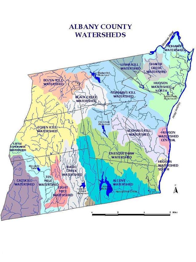
Planning Units Defined

Through discussion with our AEM Working Group this strategy adopts three planning units that
represent the three major watersheds in the County. They are the Middle Hudson Watershed,
Mohawk Watershed and the Schoharie Watershed.
(See map below)
Middle Hudson Watershed
The Middle Hudson Watershed covers the majority of Albany County. It is comprised of several
smaller watersheds that were previously used as planning units for our original county AEM
Strategy. The following list displays the watershed and 11 digit hydrologic unit codes that make
up the Middle Hudson Watershed in Albany County:
Normanskill 02020006030
Onesquethaw-Coeymans 02020006060
Hannacrois Creek 02020006070
Upper Catskill Creek 02020006140
Basic Creek 02020006140
Vlomanskill 02020006050
Normanskill Watershed
Water Quality Problem Statement:
The Normanskill Watershed contains several waterbodies that have been listed in the 1999
NYSDEC Lower Hudson River Basin Priority Waterbodies List, including various segments of
the Normanskill, Watervliet Reservoir and Bozenkill. Many of the impairments are attributed to
the large degree of urbanization within this watershed, however some pollutants impacting the
Bozenkill and Watervliet Reservoir may stem from agricultural practices. The Normanskill is a
Class A stream from Trib-18 (Schenectady County) to the Watervliet Reservoir, Class B from the
reservoir to the Delaware Avenue Bridge, and Class C from there to its mouth. The reservoir is
owned by the City of Watervliet and is the sole drinking water source. It is also the primary
drinking water source for the Town of Guilderland. Water supply use of the Watervliet Reservoir
is stressed by algal blooms and excessive aquatic vegetation. Significant development pressure
within this watershed renders responsible farming practices a necessity for open space
preservation and good community relations.
Of considerable note is the Watervliet Reservoir Watershed Protection Study authored by the
Capital District Regional Planning Commission. This study examines water quality/non-point
source pollution problems of the Watervliet Reservoir located in Guilderland NY. Development
pressures and a lack of water quality protection measures continue to threaten the long-term
viability of the reservoir as a drinking water source.
Suspected sources of nutrients and sediment as related to agriculture are:
Barnyards
Livestock
Manure/fertilizer spreading and storage
Silage storage and nutrient rich leachate
Cropland Erosion - stemming from Bozenkill being blocked in many places with downed
trees
Streambank ErosionDesired Future Condition:
To achieve a considerable reduction in agricultural sources of nutrient and sediment delivery in
the watershed. To achieve this it is imperative that riparian buffers along cropland and
pastureland must be installed.
Onesquethaw-Coeymans Watershed
Water Quality Problem Statement:
Onesquethaw Creek is a Class C waterbody [portions are class C(T) or C(TS]. Investigations
have identified possible water use impairments stemming from certain agricultural activities in
this watershed. Municipal wells located near Clarksville have been known to exhibit high nitrate
levels. Although this stream is not listed in the 1999 NYSDEC Lower Hudson River Basin
Priority Waterbodies List, a 1998 biological assessment conducted by NYSDEC Department of
Water found that water quality at most sites were slightly impacted by nutrient enrichment
from nonpoint source runoff. Additionally the assessment indicated that resident fauna in
Onesquethaw Creek is especially vulnerable to pollutants that may be rapidly transported through
the highly fractured Karst bedrock.
Coeymans Creek is a Class C(T) waterbody. Aquatic life support in Coeymans Creek is known
to experience minor impacts due to nutrient enrichment (phosphorus), siltation and other
pollutants from agricultural and other nonpoint sources.
Water quality sampling through NYSDEC Rotating Intensive Basin Studies Intensive Network
monitoring of Coeymans Creek in Coeymans, Albany County, (at Route 140) was conducted in
2003. During this sampling the biological (macroinvertebrate) sampling results indicated slightly
impacted water quality conditions. Water column sampling revealed nutrients (nitrate), total
dissolved solids and iron to be parameters of concern.
Through AEM the SWCD has inventoried approximately 20 farms in the watershed and
identified and prioritized environmental practices and concerns on 17 farms. This information
has been used to identify the highest priorities. Practices include: improvement of manure
storage facilities and manure spreading practices, drainage improvements and stream buffers.
Suspected sources of nutrients and sediment as related to agriculture are:
Barnyards
Livestock
Manure/fertilizer spreading and storage
Silage storage and nutrient rich leachate
Cropland Erosion
Streambank ErosionDesired Future Condition:
While agricultural activity may be viewed, in some cases, as having a potential impact on water
quality there is also a tremendous opportunity to work with farmers, who are stewards of large
areas of undeveloped land, toward goals of water quality improvement and stream corridor
protection. Implementation of AEM and other environmental programs has the potential to
improve water quality of the Onesquethaw and Coeymans Creeks and their tributaries and
participation should be encouraged and supported.
Catskill Creek Watershed
Water Quality Problem Statement:
Catskill Creek is a Class B waterbody [portions are class B(T)]. Investigations have identified
possible water use impairments stemming from certain agricultural activities in this watershed.
The 1999 NYSDEC Lower Hudson River Basin Priority Waterbodies List reports that public
bathing and aesthetics in Catskill Creek may be impaired by pathogens, nutrients and sediment.
Although the portion of Catskill Creek listed in the PWL is within Green County (downstream), a
biological assessment by the NYSDEC found slight water quality impacts from nutrient
enrichment and siltation in Preston Hollow (Albany County).
Suspected sources of nutrients and sediment as related to agriculture are:
Albany County Department of Health Source Water Assessment of Ten Mile Creek
Watershed (subwatershed of Catskill) found agricultural land cover (i.e., pasture) to be a
potential source of contamination. They have deemed the potential impacts to water
sources as High with the contaminant of concern - Protozoa
Streambank erosion and cropland erosion
Barnyards
Livestock
Manure/fertilizer spreading and storage
Desired Future Condition:
Determine the farms in the Preston Hollow area that might be contributing to the nutrient
enrichment and siltation issues and employ proper techniques to correct problems. There are
observed severe streambank erosion problems in the area of Preston Hollow that must be
addressed when considering water quality enhancement. Identifying soil erosion concerns on
farms in the Eight and Tenmile Creeks area should be a priority.Basic Creek
Water Quality Problem Statement:
Basic Creek is a Class A(TS) stream that extends for 54.1 miles. The aquatic life is thought to
experience minor threats due to nutrient enrichment from agricultural and other nonpoint sources.
A study of the creek conducted in 1995 found levels of slightly high eutrophication that might
threaten aquatic life. The Basic Creek is located north of the Basic Creek Reservoir, which is a
Class A water supply waterbody.
In 1999 the NYSDEC Lower Hudson River Basin Priority Waterbodies List reported the water
supply use in the Basic Creek Reservoir is impaired by algal blooms and excessive aquatic
vegetation. The report identified poor agricultural conservation practices as the source of heavy
nutrient and sediment loads. A NYSDEC Lake Classification and Inventory Program conducted
in 2004 showed Phosphorus levels in the lake often exceed state guidance values indicating
impacted/stressed recreational uses.
Suspected sources of nutrients and sediment as related to agriculture are:
Barnyards
Livestock
Manure/fertilizer spreading and storage
Silage storage and nutrient rich leachate
Cropland Erosion
Streambank Erosion
Desired Future Condition:
Identify farms that might be contributing increased levels of nutrient to the stream above the
reservoir. Focus and implement practices that are associated with high levels of Phosphorus.
Introduce farmers to programs that will increase or create riparian buffers in areas of concern.
Vlomanskill Watershed
Water Quality Problem Statement:
The Vlomanskill is a Class C waterbody [portions are class C(T)]. Investigations have identified
possible water use impairments stemming from certain agricultural activities in this watershed.
Although the 1999 NYSDEC Lower Hudson River Basin Priority Waterbodies List does not
identify the Vlomanskill as an impacted stream, previous AEM investigations conducted by the
Albany County SWCD have identified potential contributors of agricultural nonpoint source
pollution. Significant development pressure within this watershed renders responsible farming a
necessity for open space preservation and good community relations.Suspected sources of nutrients and sediment as related to agriculture are:
Barnyards
Livestock
Manure/fertilizer spreading and storage
Silage storage and nutrient rich leachate
Cropland Erosion
Streambank Erosion
Desired Future Condition:
Identify problematic agricultural areas of concern and implement BMP’s. Increase public
awareness (local boards/communities) and education of potential sources of water pollution and
implementation practices.
Hannacrois Creek
Water Quality Problem Statement:
The Hannacrois Creek is a Class A(TS) stream. The watershed contains the Alcove Reservoir
which acts as the main drinking water source for the City of Albany. A majority of the
surrounding land area is City owned and there for agriculture is not a major detriment to water
quality in the Alcove Reservoir. There are a few small farms in the area that have the potential to
have a significant impact on the reservoir. The Hannacrois Creek down stream of the Alcove is
impounded in Deans Mill for use as a water supply to the Village of Ravena. Investigations have
identified possible water use impairments (nutrients, sediment, pathogens) within the lower
watershed stemming from certain agricultural activities.
Suspected Sources of nutrients and sediment are:
Department of Health Source Water Assessment of the Hannacrois Watershed found agricultural
land cover ie, pasture to be a potential source of contamination. They have deemed the potential
impacts to water sources as Very High with the contaminant of concern being Protozoa. While
there are some facilities present, permitted discharges do not likely represent an important threat
to source water quality based on their density in the assessment area. There is also noteworthy
contamination susceptibility associated with other discrete contaminant sources, and these facility
types include: landfills. Additional sources of potential contamination include: septic systems
(along 143 and near intake), golf course and pasture (very near intake). Finally, it should be noted
that relatively high flow velocities make river drinking water supplies highly sensitive to existing
and new sources of microbial contamination.
Desired Future Condition:
Identify the farms in the area that have streams on their property making them a priority.
Implement water quality practices surrounding these streams, such properly allocated
manure/fertilizer spreading, and encouraging riparian buffers.Patroon Creek
Water Quality Problem Statement:
This watershed is located in the northeastern portion of the county that drains to the Hudson
River. A highly urbanized area, there is a small number of farms that mostly consist of vegetable
produce, hay and equine pastures. Compared to residential, commercial, industrial sources,
agriculture sources of water pollution are considered minimal.
Suspected sources of nutrients and sediment as related to agriculture are:
Barnyards
Livestock
Manure/fertilizer spreading and storage
Desired Future Condition:
A significant amount of agricultural sources of nutrient and sediment delivery should be treated.
Schoharie Watershed
The Schoharie Watershed is located in the north western portion of the county. It is comprised of
two sub-watersheds namely Fox Creek and Little Schoharie Creek (02020025090).
Fox Creek Watershed and Little Schoharie Creek Watershed
Water Quality Problem Statement:
Fox Creek is a Class C(T) stream throughout most its length in Albany County. Investigations
have identified possible water use impairments stemming from certain agricultural activities in
this watershed. The 2003 NYSDEC Mohawk River Basin Priority Waterbodies List reports that
aquatic habitat in the Foxenkill is stressed by thermal changes, sediment and pathogens, and
identifies agriculture as a primary source of pollutants.
Suspected Sources of nutrients and sediment as related to agriculture are:
Barnyards
Livestock
Manure/fertilizer spreading and storage
Silage storage and nutrient rich leachate
Cropland Erosion
Streambank Erosion – serious problem in many locations especially near Schoharie
County border
Desired Future Condition:
Identify potential sources of contamination and seek to implement practices to prevent non-point
source pollution.Mohawk Watershed
Water Quality Problem Statement:
This planning unit consists of the small, urbanized watersheds in the northeastern portion of the
county that drain to the Mohawk River. Although these watersheds are highly urbanized, there a
few scattered farms that produce vegetables, hay and livestock pasture (mainly equine).
Agricultural sources of water pollutants are minimal in comparison to
residential/commercial/industrial sources, however it is suspected that nutrients and sediment
may be exported from these operations.
Suspected Sources of nutrients and sediment as related to agriculture are:
Barnyards
Livestock
Manure/fertilizer spreading and storage
Cropland Erosion
Desired Future Condition:
Identify potential sources of contamination and seek to implement practices to prevent non-point
source pollution.The following map displays the sub watersheds throughout Albany County mentioned above: This map produced by: Albany County Office of Natural Resources
Status of Agriculture in the County

    2002 Census of Agriculture for Albany County New York

    According to the 2002 census conducted by NASS there are 484 active farms* in the County.
    69,000 acres of land in farms with an average size farm ~ 143 acres. County farms contribute
    over $19.3 million to the local economy and hire a significant number of employees. The
    primary agricultural products sold in Albany County are nursery and greenhouse crops followed
    by cattle and calves for beef and milk and other dairy products (see Table 1).

    Table 1 – Top Ranking Commodities – USDA NY Agricultural Statistics Service
                                                                                                                                      New
                                                                                                                     Albany
                         2002 CENSUS OF AGRICULTURE                                                                                   York
                                                                                                                     County
                                                                                                                                      State
                                                                                                                                     Number
   MARKET VALUE OF AGRICULTURAL PRODUCTS SOLD ($1,000)                                                 Value        Ranking            of
                                                                                                                                     Counties

Total value of agricultural products sold                                                             19,355            45             61

  Value of crops including nursery and greenhouse                                                      9,375            31             61
  Value of livestock, poultry, and their products                                                      9,980            43             59
TOP FIVE ALL COMMODITIES - VALUE OF SALES ($1,000)
  Nursery, greenhouse, floriculture, and sod                                                           5,998             9             61
  Cattle and calves                                                                                    5,266            19             54
  Milk and other dairy products from cows                                                              4,408            46             52
  Vegetables, melons, potatoes, and sweet potatoes                                                     1,246            34             58
  Other crops and hay                                                                                  1,178            43             56
TOP FOUR LIVESTOCK INVENTORY ITEMS (number)
  Cattle and calves                                                                                    9,760            40             55
  Sheep and lambs                                                                                      2,689            10             56
  Layers 20 weeks old and older                                                                        1,197            44             58
  All Goats                                                                                            1,006            6              56
TOP FIVE CROP ITEMS (acres)
  Forage - land used for all hay and haylage, grass silage, and greenchop                             24,814            38             57
  Corn for silage                                                                                     2,786             43             52
  Corn for grain                                                                                      1,506             45             51
  Cut Christmas trees                                                                                  770              16             55
  All vegetables harvested                                                                             529              31             58

    *The census definition of a farm is any place from which $1,000 or more of agricultural products were produced and sold, or normally
    would have been sold, during the census year. This definition is consistent with the definition used for current USDA surveys.
The Albany County Agricultural and Farmland Protection Board completed a Farmland Protection Plan in 2004, their mission: ‘To development goals and strategies to support and enhance Albany County’s agricultural industry and agricultural resources”. Within the plan there is listed many challenges faced by agriculture including an aging farm operator population, increasing development pressure and increasing property taxes. Although many challenges are out of our hands, as the younger generation considers farming as a career AEM can be a tool to gear their operation up for the future. A more environmentally conscience population will demand “clean farms”. Farmers can use AEM to bring their farm to the local markets by setting an example. Natural Resource Concerns Nutrient Management During Tier II farm assessment visits it is clear that farmers wish to follow nutrient recommendation and guidelines. Fuel cost and labor issues have been an impediment to sound nutrient management practices. A recent program administered by the SWCD on farms that have participated through Tier II of the AEM program provided farmers with the opportunity for SWCD staff to sample fields to uncover the fertility needs of the soil. We are still in the analysis phase of this program but farmer interest is high, continuing this program in subsequent years could provide a cost offset to help allocate nutrients to appropriate locations on the farm. In this way we hope to provide an incentive, although it does not provide fuel cost savings or solve labor issues it does however systematically prove on which fields the nutrients are most needed. Water Quality Contamination of Surface and Groundwater (nutrients, sediment, pathogens) The County’s water supply is obtained from both surface reservoirs and subsurface aquifers. The main surface water aquifers are the Alcove, Basic, Watervliet and Vly Reservoirs. NYS Department of Health Source Water Assessment of public drinking water supplies identified six surface waterbodies and nine municipal wells as having elevated susceptibility to pollution or substantial potential risks. Agricultural activities have been identified as possible sources. Erosion on Cropland Soil erosion is a major concern on much of the cropland in Albany County. The hazard of erosion is related to the slope of the land, the erodibility of the soil, the amount and intensity of rainfall and the type of plant cover. Loss of soil through erosion results in loss of nutrients and water, formation of gullies on hillsides, deterioration of tilth, detrimental sedimentation downslope and pollution of streams and water reservoirs. Many tillage and conservation practices help control erosion. Minimum tillage, no-till, cover crops, crop residue on the surface and a cropping system that has a high proportion of sod crops are effective in controlling erosion (Albany County Soil Survey). Reduced tillage and conservation practices could potentially have an economic benefit to farms given fluctuating fuel costs and labor issues.
Streambank Erosion
Streambank erosion has been found to be one the highest concerns in the farming and non-
farming community in Albany County. Farmers have expressed concerns about a loss of pasture
and cropland; and Tier II assessments correspond with the farmers concerns. While natural
stream processes are understood there still seems to be an abnormal increase in frequency and
severity of damage to streambanks. This issue can not only be corrected thru work on an
individual farm location but must be looked upon in a broad spectrum of issues through out the
community.
Albany County AEM Working Group
As previously indicated our Albany County AEM working group includes SWCD staff and
members of several agencies and organizations. The table below lists in what capacity the
members will partake in the implementation of the AEM Strategy.
Local AEM Working Group Capacity Assessment
Group/Organization/Agency Responsibilities
SWCD Administer the AEM program through direct
interaction with farmers
Secure funding through NYS Ag Nonpoint
Source Abatement and Control Grant Program
Outreach and Education
Program evaluation
NRCS Assist the SWCD with implementing the AEM
Strategy
FSA CREP/cost sharing programs
Outreach
CCE Outreach and education
Water Quality Coordinating Committee Program evaluation
Review Strategy
Office of Natural Resource Conservation Review StrategyPlanning Unit Strategies Within all three of our planning unit watersheds; Middle Hudson Watershed, Mohawk Watershed and the Schoharie Watershed our strategic goals are to address nutrient management, streambank erosion and the contamination of surface water and groundwater. AEM Base Funding Strategy We will continue to actively engage all members of the farming community that display an interest in participation in the program. No one will be turned away. To avoid focusing on one particular watershed and to be flexible as interest and new projects arise, the AEM working group has decided all watersheds are a priority. In the Middle Hudson Watershed we will continue the AEM process by conducting Tier 1 inventories on farms that have been added to our farm list. From these new Tier 1’s we will determine which farms need to proceed onto Tier 2 assessment. Those farms exhibiting resource concerns will process through Tier 3a and where possible we will seek funding to implement practices highlighted during the planning process. We will also continue to work with returning farms seeking assistance. Our goal is to be accessible to farms seeking technical assistance and conservation advice. Likewise in the Mohawk and Schoharie Watersheds we will continue the AEM process by conducting Tier 1 inventories on farms that have been added to our farm list. These new farms will proceed through the tiered process where appropriate. Referencing Goal 4 of the Hudson River Estuary Action Agenda to protect and restore the streams, their corridors, and the watersheds that replenish the estuary and nourish its web of life we will actively seek locations along streams that would benefit from riparian buffer installation. The Conservation Reserve Enhancement Program is the vehicle for achieving this goal within the farming community and will be one of the tools used to display the benefits of such management practices. The SWCD along with its partners will strive for riparian buffer installation in the following year.
BASE FUNDING STRATEGY YEAR 2008-2009
                  Watershed                  Water Quality
Planning Unit   11 - Digit HUC    Issue(s) from AEM Strategy, PWL,
                                              WQCC, etc.                    Tier 1       Tier 2       Tier 3a   Tier 4       Tier 5a

                 Normanskill      Watervliet Reservoir stressed by algal
Middle Hudson                                                                 2                         1         4            1
                02020006030      blooms and excessive aquatic vegetation

                  Foxenkill       Stressed by thermal changes, sediment
  Schoharie                                                                   4            4            2         2            1
                02020005090                   and pathogens

                  Catskill        Impaired by pathogens, nutrients, and
Middle Hudson                                                                              1            3         2            1
                02020006140                    sediment

                                    Algal blooms, excessive aquatic
                   Basic
Middle Hudson                    vegetation heavy nutrient and sediment       1            2            1                      1
                02020006140
                                                 loads

                 Hannacrois
Middle Hudson                        Nutrients, sediment, pathogens           1            1            1                      1
                02020006070

                                  High nitrate levels found in municipal
                Onesquethaw-
                                 wells, nutrient enrichment from nonpoint
Middle Hudson    Coeymans                                                                                                      1
                                    source runoff, fauna vulnerable to
                02020006060
                                         pollutants in karst bedrock

                 Vlomanskill
Middle Hudson                        Agricultural nonpoint pollution                                                           1
                02020006050
                                                                   Total             8            8         8            8         6
Communications and Outreach Strategy The successful outcome of any strategic plan is an effective communications strategy which actively engages participants in the program and serves to enlighten those which simply seek to satisfy their interest. Our communications and outreach will be geared to the county as a whole with no targeted watersheds. The SWCD publishes a quarterly newsletter which will continue to promote the AEM program. By doing so we seek to provide educational articles on farming practices to educate those less familiar with farming as well as reiterate environmentally sound production methods such as reduced tillage, grazing, riparian buffers and composting to the farming community. A lost appreciation for farming will be cultivated expressing the need and the environmental benefits farms provide. In addition to newsletter articles we will make an effort to strengthen our AEM signage program. This will provide farms the opportunity to publicize their stewardship. Partnering with our conservation partners we plan to offer educational workshops on topics such as grazing, green energy production on farms and heat recovery from anaerobic composting. Our County website will provide information about Riparian Buffers. Evaluation Strategy As the AEM Base Funding contract period runs from May of one year through May of the following year, each year in March we will review our Strategy and reassess our goals for the upcoming year.
You can also read