Peatland mapping and monitoring - Recommendations and technical overview - Food and Agriculture ...
←
→
Page content transcription
If your browser does not render page correctly, please read the page content below
Peatland mapping and monitoring
   Recommendations and technical overview
Graphic, illustrations and layout: Lorenzo Catena
Peatland mapping and monitoring
 Recommendations and technical overview

     This publication supports the Sustainable Development Goals:

            Food and Agriculture Organization of the United Nations
                                  Rome, 2020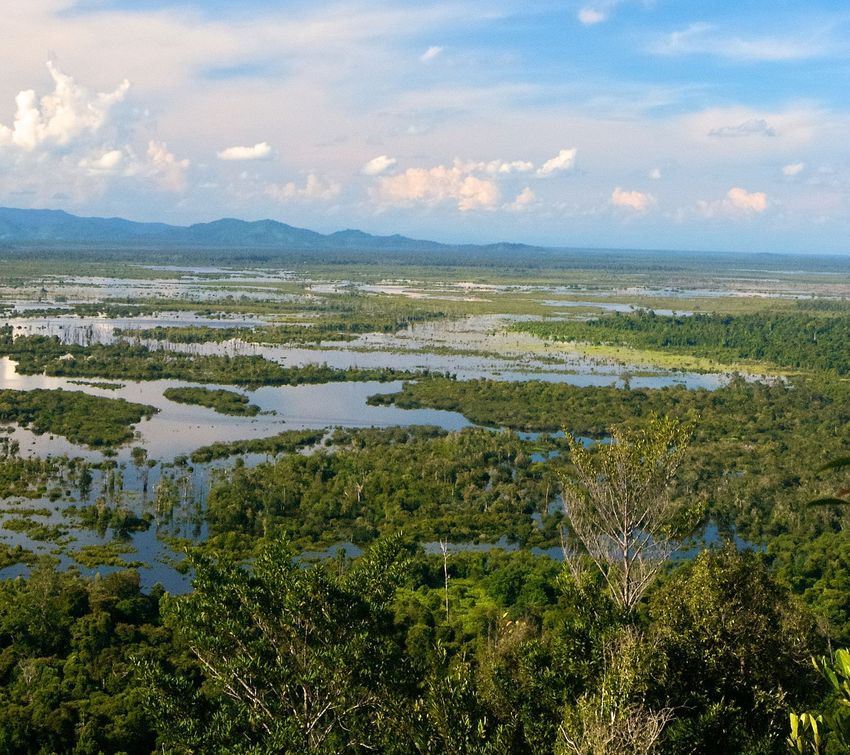
Required citation:
FAO. 2020. Peatlands mapping and monitoring – Recommendations and technical overview. Rome. https://doi.org/10.4060/ca8200en

The designations employed and the presentation of material in this information product do not imply the expression of any opinion
whatsoever on the part of the Food and Agriculture Organization of the United Nations (FAO) concerning the legal or development
status of any country, territory, city or area or of its authorities, or concerning the delimitation of its frontiers or boundaries. The
mention of specific companies or products of manufacturers, whether or not these have been patented, does not imply that these
have been endorsed or recommended by FAO in preference to others of a similar nature that are not mentioned.

The views expressed in this information product are those of the author(s) and do not necessarily reflect the views or policies of FAO.

ISBN 978-92-5-132295-6
© FAO, 2020

Some rights reserved. This work is made available under the Creative Commons Attribution-NonCommercial-ShareAlike 3.0 IGO licence
(CC BY-NC-SA 3.0 IGO; https://creativecommons.org/licenses/by-nc-sa/3.0/igo/legalcode).

Under the terms of this licence, this work may be copied, redistributed and adapted for non-commercial purposes, provided that the
work is appropriately cited. In any use of this work, there should be no suggestion that FAO endorses any specific organization, products
or services. The use of the FAO logo is not permitted. If the work is adapted, then it must be licensed under the same or equivalent
Creative Commons licence. If a translation of this work is created, it must include the following disclaimer along with the required
citation: “This translation was not created by the Food and Agriculture Organization of the United Nations (FAO). FAO is not responsible
for the content or accuracy of this translation. The original [Language] edition shall be the authoritative edition.”

Disputes arising under the licence that cannot be settled amicably will be resolved by mediation and arbitration as described in
Article 8 of the licence except as otherwise provided herein. The applicable mediation rules will be the mediation rules of the World
Intellectual Property Organization http://www.wipo.int/amc/en/mediation/rules and any arbitration will be conducted in accordance
with the Arbitration Rules of the United Nations Commission on International Trade Law (UNCITRAL).

Third-party materials. Users wishing to reuse material from this work that is attributed to a third party, such as tables, figures or
images, are responsible for determining whether permission is needed for that reuse and for obtaining permission from the copyright
holder. The risk of claims resulting from infringement of any third-party-owned component in the work rests solely with the user.

Sales, rights and licensing. FAO information products are available on the FAO website (www.fao.org/publications) and can be
purchased through publications-sales@fao.org. Requests for commercial use should be submitted via: www.fao.org/contact-us/
licence-request. Queries regarding rights and licensing should be submitted to: copyright@fao.org.
Contents

Foreword                                                VII         Existing frameworks for peatland
                                                               5.                                                      37
                                                                    reporting and verification
Executive summary                                        IX         Integrated assessment frameworks                   38

     Peatland mapping and monitoring at a glance         X          The United Nations Framework
                                                                                                                       40
                                                                    Convention on Climate Change
Contributors                                            XIV         Fire monitoring initiatives                        42

                                                                    The Convention on Biological Diversity             44
Abbreviations and acronyms                              XV
                                                                    Forest and landscape restoration initiatives       44
  1. Introduction: why map and monitor peatlands?         1
                                                               6. Country case studies                                 47

 2. Peatland mapping                                     7
                                                                    Indonesia: new monitoring methods and challenges   48

     Background                                          7          The Democratic Republic of the Congo               53

     Phase 1: collection and processing of input data   13          Peru                                               56

     Phase 2: peatland mapping                          16          The United Kingdom of Great Britain
                                                                                                                       57
                                                                    and Northern Ireland
     Phase 3: intervention and restoration mapping      16
                                                                    Lessons learned by diverse countries               59

 3. Peatland monitoring                                 19
                                                               7. Remaining questions and knowledge gaps               61
     Monitoring parameters                              20
                                                                    Groundwater level and soil moisture                62
     Taking decisions                                   23
                                                                    Reliable soil moisture detection                   62
 4. Examples of monitoring tools and approaches         25
                                                                    Greenhouse gas emission estimations                63

     Observational tools available today                27
                                                               8. Recommendations                                      65
     Analytical tools to estimate
                                                        32
     carbon balance and greenhouse gases                            Concluding remarks                                 69

                                                              Annexes                                                  70

                                                                      Annex 1. Impacts of peatland degradation         70
                                                                               on selected SDGs

                                                              References                                               71

                                                                                                                        III
Boxes
Box 1       How much soil organic carbon defines peat?                                                                        9

Box 2       Greenhouse gas emissions from peatland drainage and fires                                                       10

Box 3       Definition of peat and peatland by the IPCC                                                                     12

Box 4       Peatland restoration and rehabilitation                                                                         16

Box 5       Central European vegetation as a proxy for greenhouse gas fluxes                                                29

Box 6       Landscape-scale observation of peat surface elevation change                                                    32

Box 7       SEPAL — platform for land monitoring                                                                            33

Figures
Figure 1    Data needed for peatland monitoring — Case 1: Pristine peatlands — no ongoing drainage                           XI

Figure 2    Data needed for peatland monitoring — Case 2: Drained peatland with canals                                      XII

Figure 3    Data needed for peatland monitoring — Case 3: Restoration monitoring                                            XIII

Figure 4    Volumetric carbon content vs carbon by dry weight in soils in percentages                                         9

Figure 5    Carbon dynamic in an undrained peatland                                                                          10

Figure 6    Carbon dynamic in a drained peatland                                                                             10

Figure 7    Manual auger used for peat sampling in the field                                                                 14

Figure 8    How to determine total peat thickness in a domed peatland                                                        14

Figure 9    Decision-support tree for choosing whether rehabilitation through revegetation should be considered              17

Figure 10   Dipwells for water-table depth measurement                                                                       27

Figure 11   Automated groundwater level, rainfall and wind measurement point                                                28

Figure 12   Example of SAR data on flooded areas within a complex peat dome in Mawas area,                                  30
            Central Kalimantan and JERS-1 SAR multi-temporal composite image
Figure 13   JERS-1 SAR time series of the collapse of the peat dome in 1995—1998 in Kahiyu, Central Kalimantan, Indonesia   30

Figure 14   Illustration of radar backscatter from a typical forest element                                                  31

Figure 15   The Sustainable Development Goals that require peatland monitoring                                               38

Figure 16   Peat landscape in Peru                                                                                          55

Figure 17   Institutional setting and contribution to peatland monitoring and reporting                                      69

IV
Maps
  Map 1     The extent of peatlands in the Cuvette Centrale, Congo Basin                                                        53

  Map 2     Updated map of the extent of peat in the United Kingdom                                                             58

Tables
  Table 1   Remote sensing tools and their characteristics, useful for peatland mapping                                         11

  Table 2   Examples of parameters for monitoring different types of peatlands,                                                 21
            suggested minimum frequency and utility for climate reporting indicators
  Table 3   Summary of tools for peatland monitoring                                                                            26

  Table 4   Examples of SDG targets, definition of goals, indicators and potential monitoring parameters related to peatlands   39

  Table 5   Peat-related components of The Association of Southeast Asian Nations’ roadmap                                      43

  Table 6   Peat-related Aichi biodiversity targets and relevant indicators                                                     45

  Table 7   The impacts of peatland degradation and restoration on selected SDGs                                                70

                                                                                                                                 V

Foreword
The world’s leading peatland experts have come to a collective conclusion – comprehensive peatland mapping and
monitoring are urgently needed. Peatlands have a great potential to influence global greenhouse gas emissions,
and in this decade we need to take urgent and innovative actions to limit global warming to a maximum of 2 °C.
In most cases worldwide, peatlands have been drained and degraded due to the lack of knowledge about their
location, extent, benefits and potential for climate change mitigation and risk reduction. Current estimates suggest
11–15 percent of peatlands on Earth have been drained, and another 5–10 percent are degraded due to other changes
such as removal or alteration of vegetation. These degrading peatlands consequently emit huge amounts of
greenhouse gases that persist for years if not decades.

The scientific basis for mapping and monitoring peatlands has developed rapidly in recent years. Countries must
take advantage of and consider adopting practical and innovative approaches and tools for peatland mapping and
monitoring into national monitoring and reporting frameworks. Mapping and monitoring can be used to inform
climate and biodiversity policies and commitments, as well as to continuously adapt peatland restoration efforts.

Peatland mapping and monitoring are both highly complex endeavours, but are key to understanding the real extent
and location of these huge carbon stores and guide the course of action for ecosystem conservation and restoration
during this decade and beyond. It is part of FAO’s mandate to support developing countries with advancing the
sustainable management of peatland landscapes, and develop national capacity for peatland mapping and
monitoring, as well as to foster knowledge sharing and data generation. FAO’s peatland network consists of dozens
of experts and organizations with the shared mandate to jointly find solutions to conserve the carbon in the soil
while fostering sustainable livelihoods and development. We recognize the important advances already made in the
subject in temperate and boreal regions and stress the need for continuing monitoring of peatland status in tropical
as well as in temperate and boreal regions.

“Peatlands mapping and monitoring: Recommendations and technical overview” is the result of 35 contributors from
14 countries and different organizations working together to provide examples, tools, methodologies and solutions
to peatland mapping and monitoring challenges, especially in developing countries. These recommendations are an
important step forward in guiding the world on the best ways to integrate peatlands into land monitoring systems
to further facilitate the conservation and restoration of these unique ecosystems. I encourage you to take full
advantage of the information included in this publication.

                                             Mette Wilkie
                                             Director
                                             Forestry Policy and Resources Division,
                                             Food and Agriculture Organization of the United Nations

                                    © FAO

                                                                                                                       VII
Executive summary
Mapping peatlands is the basis for successful monitoring systems. Worldwide, innovative mapping approaches
have facilitated the inclusion of peatland areas into sustainable land use management plans and conservation
strategies. Monitoring changes in peatland ecosystems, be they natural, degraded, or in the process of restoration, is
instrumental in maintaining peatland’s water, species richness and carbon. Robust mapping processes offer a solid
baseline for monitoring and help establish management objectives for specific peatland areas.

This report presents the peatland mapping methodologies commonly used – based on ground and remotely
sensed input data. It also offers an overview of advantages and limitations of different monitoring approaches as
a practical guide to facilitate decision-making and cater for country-specific requirements, in order to ensure that
emissions and emission reductions are measurable, reportable and verifiable. It also provides information on other
benefits from peatland conservation, restoration, rehabilitation and sustainable management. Country case studies
present examples of current needs and recent achievements, in both mapping and monitoring. Suggestions for an
architecture of peatland monitoring and how it could be organized within a country’s institutions are also provided.

Global conventions and national policy frameworks recognize the importance of peatlands for protecting habitats
and biodiversity, as large and vulnerable carbon stocks, and (when degraded) as globally important sources of
greenhouse gas emissions. Countries should consider mapping, monitoring and reporting peatlands for national
and international processes including general land use planning, nationally determined contributions to the Paris
Climate Agreement, national adaptation plans, nationally appropriate mitigation actions, as well as fire risk reduction
and other disaster risk reduction strategies. The national policy frameworks contribute to the achievement of
international commitments, as well as helping to ensure better conditions for communities.

Countries, practitioners, researchers and technical agencies can use this report to identify mapping and monitoring
needs, and define suitable approaches and tools to ultimately reflect peatlands into national land use monitoring
systems, such as national forest monitoring systems. Soil carbon and emissions from soils have long been
underestimated, and existing systems may also need to be adapted to fully integrate peatland considerations.

Keywords: greenhouse gas; peatlands; organic soils; monitoring;
reporting; climate change; wetland; IPCC; remote sensing;
Earth observation; data; water; plant; peat; UNFCCC; emission reduction

                                                                                                                          IX
Peatland mapping
and monitoring at a glance
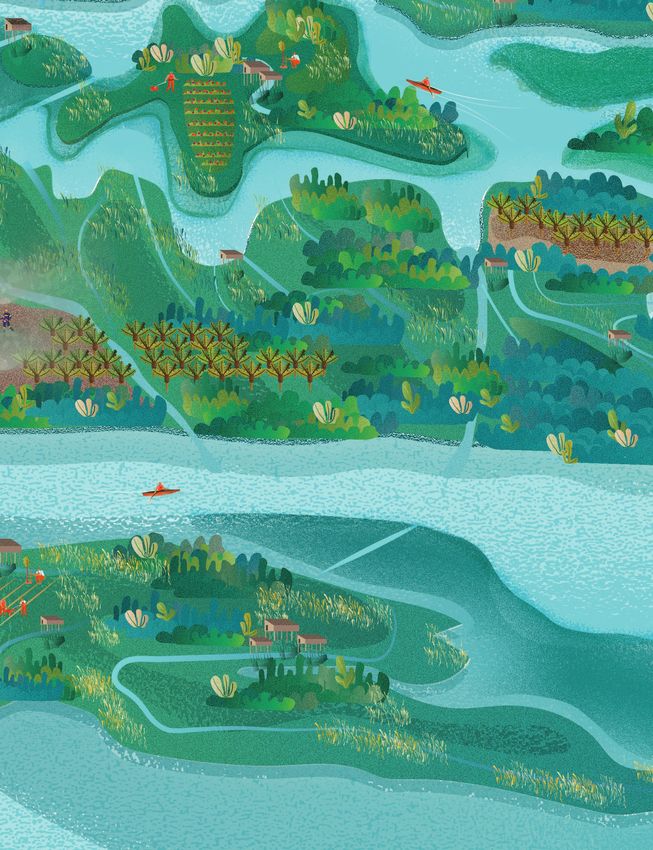
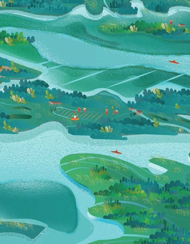
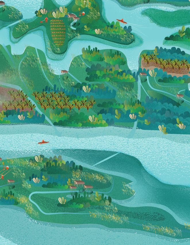
Peatland mapping and monitoring require collection and measurement of different data types depending
on the status of the peatland area. In pristine peatlands (Figure 1) information on natural characteristics is
needed to monitor future changes, including potential climate change impacts that may lead to increased
emissions and disaster risks.
If drainage is undertaken (Figure 2), peatlands generally become sources of greenhouse gas emissions, and
additional parameters must be monitored to support corrective action and avoid continued degradation,
and to contribute information to report for various conventions. Peatland restoration monitoring (Figure 3)
can inform the design, strategy, selection of site and management approaches, and improve restoration
efforts through technical adjustments.
© FAO / Maria Nuutinen
XFigure 1 Data needed for peatland monitoring — Case 1: Pristine peatlands — no ongoing drainage XI
XII

      Figure 2   Data needed for peatland monitoring — Case 2: Drained peatland with canals
Figure 3 Data needed for peatland monitoring — Case 3: Restoration monitoring XIII
Contributors
                      Jukka Alm Natural Resources Institute Finland (Luke)
       Muhammad Askary Masjkur Ministry for Environment and Forestry, Indonesia
               Bambang Arifatmi Food and Agriculture Organization of the United Nations, Indonesia
                 Amélie Arquero Food and Agriculture Organization of the United Nations, Democratic Republic of the Congo
                    Rebekka Artz James Hutton Institute
                    Uwe Ballhorn Freelance
      Jean-Jacques Bambuta Boole Ministry of Environment and Sustainable Development, Democratic Republic of the Congo
                       Felix Beer Greifswald Mire Centre
                  Andrew Coupar Scottish Natural Heritage
               John Couwenberg University of Greifswald, Greifswald Mire Centre
                     Ian Crosher IUCN, Natural England
                 Rémi d’Annunzio Food and Agriculture Organization of the United Nations
                     Chris Evans UK Centre for Ecology and Hydrology
                      Julian Fox Food and Agriculture Organization of the United Nations
                   Adam Gerrand Food and Agriculture Organization of the United Nations, Indonesia
                 Emma Goodyear IUCN UK Peatland Programme
                  Andrew Groom CGI
                   Dirk Hoekman SarVision
                  Aljosja Hooijer Deltares
                   Hans Joosten University of Greifswald, Greifswald Mire Centre
                   Erik Lindquist Food and Agriculture Organization of the United Nations
                  Esther Mertens Food and Agriculture Organization of the United Nations
                     Kai Milliken Food and Agriculture Organization of the United Nations
                    Peter Moore Food and Agriculture Organization of the United Nations
               Daniel Murdiyarso Centre for International Forestry Research (CIFOR)
             Cleto Ndikumagenge Food and Agriculture Organization of the United Nations, Democratic Republic of the Congo
                        Till Neef Food and Agriculture Organization of the United Nations
                  Maria Nuutinen Food and Agriculture Organization of the United Nations
                     Susan Page University of Leicester
                 Marieke Sandker Food and Agriculture Organization of the United Nations
       Laure-Sophie Schiettecatte Food and Agriculture Organization of the United Nations
                      Hesti Tata FOERDIA, Ministry for Environment and Forestry, Indonesia
      Pedro Raul Tinoco Rodriguez Ministry of Environment, Peru
               Ronald Vernimmen Deltares
                   Laura Villegas Food and Agriculture Organization of the United Nations
                 Albert Sulaiman Indonesian Agency for the Assessment and Application of Technology (BPPT)

XIV
Abbreviations and acronyms
AFOLU agriculture, forestry and other land use LDN Land degradation neutrality
is a target defined under the UNCCD
AGB aboveground biomass
LIDAR Laser Imaging Detection and Ranging
ASEAN Association of Southeast Asian Nations
MEAs multilateral environmental agreements
BRG Badan Restorasi Gambut
MINAM Ministerio del Ambiente
(Peatland Restoration Agency of Indonesia)
(Peruvian Ministry of Environment)
C Carbon
MoEF Indonesian Ministry of
CBD Convention on Biological Diversity Environment and Forestry
MRV measurement, reporting and verification
CIFOR Centre for International Forestry Research
NAMA Nationally Appropriate Mitigation Action
DOC dissolved organic carbon
NAP National Adaptation Plan
DRR disaster risk reduction
NDC Nationally Determined Contribution to the
EbA ecosystem-based adaptation Paris Climate Agreement under the UNFCCC
ENSO El Niño–Southern Oscillation PRIMS Indonesian Peatland Restoration
Information and Monitoring System
FLR forest and landscape restoration
RFMRC Regional Fire Management
Resource Centre (Indonesia)
GFMC Global Fire Monitoring Centre
RSPO Roundtable on Sustainable Palm Oil
GHG greenhouse gas
SDGs Sustainable Development Goals
GPI Global Peatlands Initiative
SEPAL System for Earth Observation
GWFN Global Wildlife Fire Network Data Access, Processing and
Analysis for Land Monitoring
GWL ground water level
SFDRR Sendai Framework for Disaster Risk
InSAR interferometric synthetic aperture radar Reduction 2015–2030
UNFCCC United Nations Framework
IPCC Intergovernmental Panel on Climate Change
Convention on Climate Change
IUCN International Union for UNCCD United Nations Convention
Conservation of Nature to Combat Desertification
LAPAN Lembaga Penerbangan Dan Antariksa VHR very high resolution
Nasional (National Institute of Aeronautics
and Space of Indonesia)
Chemical formulae and units
CH4 Methane Gt gigatonne
CO2 Carbon dioxide N2O Nitrous oxide
CO2eq Carbon dioxide equivalent Pg petagram
XVChapter 1
Introduction:
why map and
monitor peatlands?
by Susan PageChapter 1 Introduction: why map and monitor peatlands? by Susan Page Peatlands, also called “organic soils”, “bogs”, “fens”, “swamps” and “mires”, are the world’s most carbon-dense terrestrial ecosystems. Peatlands are formed from partially decomposed plant remains that have accumulated over thousands of years under conditions of waterlogging. Peat soils hold an estimated 650 billion tonnes (Gt = Pg) of carbon on only 3 percent of the Earth’s land surface – a carbon store that is equal in magnitude to the amount of carbon in the Earth’s vegetation, and more than half of the carbon in the atmosphere (Yu et al., 2010; Page et al., 2011; Dargie et al., 2017). Peatlands thus play a critical role in the global carbon cycle and in climate regulation. However, peatlands also deliver a range of other benefits for humanity, including water regulation, flood control, food, and cultural and livelihood opportunities. They support a diversity of habitats and unique and rare plant and animal species. The layers of accumulated peat contain an archive of information on changes in climate, vegetation and human activity since the last Ice Age. Peatlands are, however, highly vulnerable. Undisturbed peatlands are characterized by water levels that are close to the surface throughout the year. Near-constant waterlogging and the consequent lack of oxygen slows down decomposition by micro-organisms and, as a result, the organic material (peat) accumulates slowly over time. In northern peatlands, the accumulation of 1 m of peat may take over a thousand years, but as some peatlands have been accumulating over several millennia, they have reached depths of 5 m or more (Yu et al., 2010). In the tropics, higher plant productivity has resulted in even deeper deposits – exceeding 15 m in some locations (Page et al., 2011). When the water table in a peatland is drawn down, for example to permit agriculture or forestry, oxygen enters the upper peat column. This facilitates microbial degradation (oxidation) of the peat and a rapid loss of stored carbon to the atmosphere, mainly in the © CIFOR / Ramadian Bachtiar form of the greenhouse gas (GHG) carbon dioxide (CO2). Undamaged peatlands are usually net accumulators of carbon – i.e. more carbon is taken up via photosynthesis and carbon capture by the vegetation and peat than is lost from decomposition and subsequent release into the atmosphere. The capacity of intact peatlands to sequester carbon from the atmosphere and to store it over a long term is key to their role in climate change mitigation. In drained peatlands, however, this role is reversed, with decomposition rates many orders of magnitude greater than in the absence of oxygen. Ongoing anthropogenic disturbance can therefore convert peatlands from slow carbon sinks and long-term stores to fast carbon sources, as carbon stored over millennia is released back into the atmosphere within a matter of decades. Understanding the location and scale of these disturbances is vital in supporting efforts to rehabilitate and restore peatland functions, including their role in climate change mitigation. 2
The most widespread drainage-based uses of peatlands today are for agriculture and forestry
and, to a lesser degree, for peat extraction. Although enormous extents of peatlands in North
America and the Russian Federation are still intact, around 20–25 percent of the world’s
peatlands have been moderately or significantly degraded through disturbances to their
hydrology and vegetation, especially in Europe, Central and Southeast Asia, East Africa,
southernmost America and the Amazon. Globally, the most widespread uses of peatland today
are for forestry and agriculture, amounting to an estimated total area in excess of 1 million km2
(Joosten and Clarke, 2002) and possibly exceeding this area if peatland used as pasture for
extensive livestock grazing is also included (FAO, 2014). (See also: Leifeld, J., et al. 2019.) Some
of the most rapid and extensive land use changes have taken place recently in Southeast Asia
as a result of land conversion to large-scale plantations or smaller-scale agriculture. Around
the world, peatland drainage and associated peat fires are estimated to be responsible for

                                                                                                       3
Peatland mapping and monitoring — Recommendations and technical overview
approximately 5 percent of anthropogenic CO2 emissions (IPCC, 2014b). a measure to fight the climate crisis and enhance food
Next to the globally significant emissions, important local and regional security, water supply and biodiversity. The Decade covers
impacts of peatland drainage include increased risk of peat fires and all ecosystems, but focuses on terrestrial, freshwater
haze, which cause severe impacts on human health – for example, the (including peatlands) and mangrove systems (UN, 2019a).
peatland fires in Southeast Asia and the boreal zone during 2019 – and
• FAO is a technical agency of the United Nations
of flooding (due to land subsidence caused by peat compaction and
supporting countries to improve the sustainability of
oxidation).
cropland, livestock, forestry, fisheries and aquaculture
At global and national levels, peatlands receive growing recognition management, including support to reduce GHG emissions
and are integral to a number of national and international conventions and avoid losses of other ecosystem services caused by
and policies aimed at protecting habitats, biodiversity and carbon unsustainable peatlands management. FAO provides tools
stocks, and reducing GHG emissions. and guidance for peatland monitoring and development of
sustainable livelihood sources from peatland landscapes.
The most relevant conventions are:
• The International Union for Conservation of Nature
• The United Nations Framework Convention on
(IUCN) passed a resolution, “Securing the future for
Climate Change (UNFCCC) includes peatlands (organic
global peatlands”, at the 2016 World Conservation
soils) in its Kyoto Protocol, the Paris Climate Agreement,
Congress, calling for action to protect, restore and
and national GHG reporting and accounting. The
sustainably manage peatlands (IUCN, 2016).
Intergovernmental Panel on Climate Change (IPCC) gives
technical recommendations to the UNFCCC, and has • The Bonn Challenge is a global effort to bring
produced guidance on reporting on GHG emissions from 150 million ha of degraded and deforested land into
drained, rewetted and burning organic soils. Reporting restoration. By 2020 and 350 million ha by 2030. The
has to follow the principle of transparency with respect to initiative, launched by an international coalition in 2011,
measurement, reporting and verification (MRV). also encourages the restoration of peatlands.
• The Convention on Biological Diversity (CBD) requires • Within Europe, the EU Habitats Directive includes
in its Aichi Targets the conservation and restoration peatland ecosystems as priorities for conservation
of peatlands, highlighting their role in mitigating and and restoration, while the European Climate Change
adapting to climate change, as well as supporting rare Programme requires most peatlands and organic
and threatened wildlife. soils in Member States to be accounted for by 2020.
UNFCCC has particularly important implications for peatlands because
• The Ramsar Convention on Wetlands has passed
countries have to account for GHG emissions associated with peatland
several resolutions and recommendations on peatland
use, such as from forestry, agriculture and extraction, in their national
conservation, wise use and climate change.
inventory submissions under the Kyoto Protocol.
• The United Nations Convention to Combat Building on these international agreements and policy initiatives,
Desertification (UNCCD) acknowledges peatlands as an various countries have taken steps to conserve and protect their
important component of land use planning and integral peatlands, and restore degraded sites. Successful results depend on
to the climate change agenda, because of their carbon robust and user-friendly assessment and monitoring methodologies
storage and the opportunity their restoration offers for to identify and better understand the changes and impact of activities
reducing GHG emissions (UNCCD, 2015) and achieving part in both pristine and particularly valuable peatlands, as well as in
of the land degradation neutrality (LDN) target. degraded sites. Effective peatland mapping and monitoring would
A growing number of international agencies and initiatives also enable users to:
underline and support improving management, including the • locate peat deposits to more accurately assess
conservation and restoration of peatlands: peatland area and carbon stock, including remote
and inaccessible sites;
• The United Nations Environment Programme, leading
the global environment agenda, and the Food and • obtain information on the peatland condition
Agriculture Organization of the United Nations (FAO) (i.e. intact or degraded, and the extent, type and
have recently been asked to lead the implementation of likely causes of degradation), in order to identify
the 2021–2030 UN Decade on Ecosystem Restoration as areas at risk of degradation or in need of restoration;
4Chapter 1 — Introduction: why map and monitor peatlands?
• formulate appropriate action plans, including law and integrate peatlands into national systems. Effective peatland
enforcement, rehabilitation or restoration; and mapping and monitoring will probably combine contemporary
remote-sensing techniques with the necessary ground-truthing
• monitor the success of management interventions and and field measurements. For example, established remote-sensing
allow corrective action if targets are not being met. techniques can be used to assess land cover, land use and vegetation
condition at landscape scale, whereas newer developments may allow
Mapping of peatland occurrence is a prerequisite for monitoring
the monitoring of GWL and soil moisture (a proxy measure for water
peatland change. Maps of peat location, extent and condition are
level and GHG emissions) as well as peatland subsidence (a proxy for
required to monitor potential conflicting land use activities (such as
water level and carbon loss).
agriculture or forestry, infrastructure development or extraction).
The location of drainage canals or ditches, logging tracks and roads is
required in order to identify current and incipient threats. Moreover,
historical examples of fire occurrence are also useful indicators for
anticipating additional threats and emissions.
Peatland monitoring methods will differ, depending for example on the
extent of the peatland, the nature of any human disturbances, planned
restoration interventions, required resolution, objectives, accessibility,
available resources, and target environmental parameters. The ideal
approach would ensure that emissions and emission reductions are
measurable, reportable and verifiable, while also providing information
on the delivery of other peatland ecosystem services in order to fulfil
the reporting requirements to other conventions and the overlying
United Nations Sustainable Development Goals (SDGs, see Chapter 5).
Ideally, peatland monitoring will form part of national land monitoring
and reporting system(s) and build on them.
Sound methodologies are needed in the collection and collation of
key indices that allow the assessment, through widely recognized
proxies, of peatland hydrological function and carbon loss. This will
require robust, accessible supporting assessments and monitoring
methodologies, for the identification of both pristine and particularly
valuable peatlands and of degraded sites, which should be targeted for
management interventions. The value of peatlands can be defined as
water provision and storage, flood control, carbon storage, biodiversity
and other ecosystem services.
Especially at the early stages of mapping, remote-sensing
approaches need to be combined with on-site measurements
of, for example, GHG emissions, peat subsidence, ground water
© FAO / Eko Bambang Subiantoro
level (GWL), soil moisture, vegetation cover and diversity, in order
to calibrate and validate the remote-sensing results. On-site
measurements – or “ground-truthing” – of remote-sensing approaches
offer opportunities as well as technical challenges. The main challenge
is to obtain on-site high-quality measurements across satisfactory
temporal and spatial scales (encompassing different site conditions,
diurnal, seasonal and annual variability), which may require
substantial financial and technical resources.
The case studies show that some countries have already applied
various peatland mapping and monitoring approaches, although these
are rarely sufficiently comprehensive. Others have developed some
elements but need technical support and capacity-building to set up
5Chapter 2
Peatland mapping
by Ronald Vernimmen, Aljosja Hooijer, Hans Joosten,
Uwe Ballhorn, Maria Nuutinen and Hesti TataChapter 2
Peatland mapping
by Ronald Vernimmen, Aljosja Hooijer,
Hans Joosten, Uwe Ballhorn, Maria Nuutinen
and Hesti Tata
Mapping of peatlands has been addressed with many different upon the field and secondary data already available in different
methodologies, and detailed guidelines are available for a variety countries, and the data sources usually considered in peatland
of locations (e.g. Barthelmes, Ballhorn and Couwenberg, 2015; mapping exercises. Bearing in mind the key features for peatland
Bourgeau-Chavez et al., 2018; Gumbricht et al., 2017) Peatlands are delineation and mapping, countries are encouraged to design their
formed in different climatic zones, and thus hold several vegetation mapping methodologies and adapt them to their specific needs, goals,
types and occur in different ecosystem settings. In tropical climates, information availability and landscape features. Mapping activities are
for example, they might occur in mangroves and peat swamp forests, necessary to integrate peatlands into productive and conservation
while in subtropical and warm temperate climates most have reed planning.
or sedge vegetation, and in boreal, cool temperate, subarctic and
arctic regions most are dominated by mosses (Gumbricht, 2012;
Prager, Barthelmes and Joosten, 2006). Consequently, approaches BACKGROUND
to mapping need to vary depending on ecologic and landscape Key features of peatland delineation
features, and the availability of information to define the occurrence
of peatlands and peat soils. A combination of various ecologic and Comprehensive field-based information on the extent of peatlands
landscape variables – as well as expert analyses – is used to identify is often lacking, particularly in the case of inaccessible tropical
probable peatlands, and produce detailed peatland maps. peatlands. In such cases, the combined use of remote sensing and
Prior to defining monitoring needs, baseline maps are required to field measurements may provide comprehensive peatland distribution
identify the peat location and the historic and current land cover maps with reasonable accuracy and quantifiable uncertainties.
and land use characteristics. It is recommended to incorporate Lawson et al. (2014) identified four features, detectable with the help
an internationally recognized definition of peatland for mapping of remote sensing, which distinguish pristine peatlands (especially
(see e.g. Box 1, Box 2, and the Chapter 8. Recommendations). Knowing tropical peatlands) from surrounding non-peat ecosystems:
the location of drainage canals or ditches, logging tracks, roads, and • low vegetation species richness;
preferably local livelihood sources (e.g. hunting, fishing, gathering
• distinctive vegetation structure;
non-timber products, irrigation with water extracted from peatlands,
• distinctive topography; and
peat extraction) helps to identify current and future threats and
processes affecting and/or protecting peatlands. Historical fire • high water tables.
occurrence is also a useful indicator for further threats given that Pristine peatlands often have a lower vegetation diversity compared
once-burnt areas burn more easily again. Maps of legal status and with surrounding ecosystems. For example, within the peatlands of
concession extents, together with potential spatial and other land use South and Central America, some parts of Africa, and on the island
plans, are recommended to be integrated into the maps to identify and of New Guinea, palms are often more dominant than in upland
avoid potential issues and future threats. forests, and even sometimes occur as mono-dominant stands.
This chapter presents the main components for peatland mapping and However, in some peatland forests vegetation diversity can also be
delineation, which correspond to the essential monitoring parameters high (Brady, 1997; Rieley and Page, 2005). As low vegetation species
discussed in the following chapters. Also, the data sources listed richness cannot be directly detected with remote-sensing systems,
here – focused on remote-sensing techniques – are intended to build distinctive vegetation structure acts as proxy.
8Chapter 2 — Peatland mapping
The vegetation structure of pristine peatlands is very often (but not Water tables in undrained peatlands lie close to or above the surface
always) distinct from that of surrounding vegetation. For example, throughout the year but can be also subject to natural fluctuation of
tropical low-pole peat swamp forests are characterized by more open several decimetres depending on the season – wet or dry.
canopies, low canopy height with thin stems, and high stem density,
Low vegetation species richness, distinctive vegetation structure,
or no trees at all (Anderson, 1983; Ballhorn, Jubanski and Siegert, 2011;
and topography can directly be detected through remote sensing.
Jaenicke et al., 2008; Lawson et al., 2014; Page et al., 1999; Phillips,
Whereas any of these features alone would not be sufficient to
Rouse and Bustin, 1997).
definitely detect peatlands, a combination of two or more often leads
Most peatlands occupy a specific topographic or geological setting, to much clearer results (Draper et al., 2014). As all key features related
such as coastal peatlands in Southeast Asia, subsiding basins, to vegetation and high water tables are immediately altered through
dendritic drainage river networks (many contributing streams), vegetation clearance and drainage, it is crucial to assess historical
etc. Furthermore, many peatlands, such as Indonesia’s tropical remote-sensing data. Finally, all approaches based on remote
peatlands, are dome-shaped and can be detected by elevation sensing need a satisfactory set of field data – such as soil sampling –
data (e.g. Ballhorn, Jubanski and Siegert, 2011; Jaenicke et al., 2008; to validate the mapping results.
Lähteenoja et al., 2009; Phillips, Rouse and Bustin, 1997).
Box 1 How much soil organic carbon defines peat?
The proportion of organic matter that a soil layer must hold to be called “peat”, varies greatly among countries and
disciplines. In soil science, peat soils are included in “organic soils”, which are distinguished from “mineral soils” based on the
dry weight percentage of organic carbon (gram of carbon per gram of soil × 100). The vertical solid line in Figure 4 denotes
18 percent carbon content by weight, which is the threshold above which soil is called “organic”. This boundary varies
between 12 and 18 percent depending on the proportion of clay in the soil. However, this boundary is not very appropriate
from the climate point of view, because the percentage reveals little about the volumetric carbon content (g/cm3), i.e. the
amount of soil carbon that upon drainage is exposed to oxygen and that can thus be emitted as CO2.
Pure peat has a high percentage of carbon by weight (approx. 57 percent), but a low volumetric carbon content
(Warren et al. 2012; Roßkopf et al. 2015). In comparison, mineral soil weighs much more and with three percent of carbon
by weight can have just as much carbon per volume (Figure 4, based on Ruehlmann & Körschens 2009). After drainage,
both soils emit the same amount of CO2. The traditional definition of a peat soil based on 18 percent carbon content by
weight or higher is thus problematic as many soils with lower carbon content – but equal or higher emission potential –
can be overlooked by such standard country definitions.
Figure 4 Volumetric carbon content vs carbon by dry weight in soils in percentages
Mineral soil Organic soil
0.14
0.12
volumetric carbon content (gC/cm3)
0.1
0.08
0.06
0.04
0.02
0
0 3 10 18 20 30 40 50 57 60
soil organic carbon content (% by dry weight)
Source: based on Ruehlmann & Körschens, 2009
9Peatland mapping and monitoring — Recommendations and technical overview
Box 2 Greenhouse gas emissions from peatland drainage
Atmosphere and fires
In a pristine peatland, a high water table maintains the anoxic conditions of the peat and the peatland is a net CO2 sink (Figure 5).
When a peatland is drained and water is no longer present in CO the
2 soil pores, oxygen enters and oxidizes the peat through
biological and chemical processes. Drainage CO2 also increases the risk of fire. As a result of biological oxidation carbon is lost
to the atmosphere, mainly as CO2 (Figure 6), and N2O as a result of peat fires, a combination of various gases including CO2, CO
and methane (CH4) is emitted. Climate and temperature, N2O as well as GWL, have a clear influence
CO2 on the rate of peatland CO2
emissions. Both drainage and fire also cause enhanced discharge of carbon as dissolved organic carbon (DOC) and particulate
organic carbon (POC) into downstream aquatic ecosystems. Due to losses of organic matter, the peatland surface subsides, and
Oxic peat
this subsidence can Water
be measured
table and used as an indicator of carbon losses. CH4 emissions are also generated in ditches and
canals, where plant materials and peat detritus flushed from the land
Anoxic peataccumulate and
CH4 decompose under anaerobic conditions.
Figure 5 Carbon dynamic in an undrained peatland
Atmosphere
CO2
CO2
CH4 CO2
Water table
CH4
Anoxic peat
Source: Renou-Wilson et al., 2011
Figure 6 Carbon dynamic in a drained peatland
Atmosphere
CO2
CO2
N2O
N2O CO2
Oxic peat
Water table
Anoxic peat CH4
Source: Renou-Wilson et al., 2011
Non-carbon GHG emissions, mainly nitrous oxide (N2O) from drained peatlands are a consequence of the mineralization of
nitrogen compounds during peat decomposition and are further enhanced by applications of mineral and organic nitrogen
fertilizers. Nitrous oxide is an important GHG as it has a global warming potential of 310 times higher than that of CO2 over a
Atmosphere
100-year time horizon (FAO, 2014).
CO2
CO2
CH4 CO2
10 Water table
CHChapter 2 — Peatland mapping
Remote sensing mapping and data sources Optical sensors are limited by weather conditions and rely upon solar
illumination or thermal radiation. To compensate for frequent cloud
In addition to the secondary and field data used in previously cover, especially in the tropics, satellite imagery with high temporal
developed mapping methodologies, remote sensors have been widely resolution should be used (e.g. Sentinel-2).
used for peatland identification. Main types are high-resolution optical
sensors and radar satellite systems, which differ in the way they Radar satellite systems
function and offer information. Radar remote sensing from space has developed greatly over recent
decades, in parallel with the development of radar sensors, but also
High-resolution optical sensors with developments in space technology, computing capacity, image
Optical remote sensing makes use of visible, near-infrared and processing techniques and physical understanding of the interaction
short-wave infrared sensors to form images of the Earth’s surface by of radar waves with the terrain. Radar-based satellites are not affected
detecting the solar radiation reflected from targets on the ground. by weather conditions and can penetrate clouds and, to some degree,
Freely available optical imagery from high-resolution satellite sensors vegetation.
(with resolution of 10–30 m; e.g. Landsat, Sentinel-2, etc.) has been In 1978, NASA launched SEASAT, equipped with the first space-borne
primarily used to map peatlands (e.g. Lähteenoja and Page, 2011; synthetic aperture radar (SAR). This radar satellite used the so-called
Langner, Miettinen and Siegert, 2007; Miettinen and Liew, 2010; L-band wavelength of ± 25 cm. Radar wavelengths are much larger
Phua et al., 2007; Wahyunto, Heryanto and Widiastuti, 2006; than wavelengths used for optical systems and have the capability to
Wahyunto, Ritung and Subagjo, 2003, 2004; Wijedasa et al., 2012). penetrate clouds, mist and rain. Moreover, radar is an active system,
The new generation of very high resolution (VHR) multispectral which means it has its own source of illumination and is independent
imagery (with resolution of ≤10 m; e.g. SkySat [Planet: 0.72 m], of solar illumination, allowing imaging radar to observe 24 hours per
Doves [Planet: 3 m], WorldView [2 m], IKONOS [4 m], RapidEye [5 m]), day, each day of the year.
and others might considerably enhance future peatland delineation.
However, as these are commercial operations, they come at a price Besides L-band radar, other radar systems with shorter wavelengths
and may not be accessible to developing countries. exist, such as C-band and X-band radar (Table 1).
Table 1 Remote sensing tools and their characteristics, useful for peatland mapping
Orbital
Satellites / Period of Wave-length Spatial
Country Band Polarisation repeat
sensors operation (cm) resolution (m)
(days)
ALOS / PALSAR Japan 2006—2011 L 23.6 Single, Dual, Quad 10—100 46
ALOS-2 / PALSAR-2 Japan 2014—present L 23.8 Single, Dual, Quad 1—100 14
NISAR NASA, India Start in 2021 L 23.8 Single, Dual, Quad 3—10 12
Sentinel-1 Europe 2014—present C 5.6 Single, Dual, Quad W—20 12 (6)
RADARSAT
Canada 2019—present C 5.6 Single, Dual, Quad 1—100 12 (4)
Constellation
2007—present
TerraSAR-X TanDEM-X Germany X 3.1 Single, Dual 1–16 11
2010—present
PAZ Spain 2019—present X 3.1 Single, Dual 1—16 11
COSMO-SkyMed Italy 2007—present X 3.1 Single, Dual 1—100 16
11Peatland mapping and monitoring — Recommendations and technical overview
The longer the wavelength, the deeper the waves penetrate the The X-band satellites TerraSAR-X and COSMO-SkyMed provide images
forest canopy. L-band radar reflections are mainly caused by trunks with much higher resolution but these images cover smaller areas.
and large branches, while the shorter C- and X-band radar are mainly They are typically used where high or very high resolution is required
reflected by the leaves of the upper canopy, which means they (see also Lucas et al., 2012; GOFC-GOLD, 2013; 2015; GFOI, 2013).
can help to observe peatland soil moisture only where there are
A multisensory1 and iterative2 approach that includes historical
no trees. Radar systems with short waves also have higher spatial
remote sensing (see next section) and field data is recommended3.
resolution. This makes L-band radar more suitable for land cover and
This approach can be split into three phases: Phase 1 for collection
forest biomass monitoring, while X-band radar is better for detecting
and processing of input data; Phase 2 for peatland mapping (including
disturbances in the forest canopy at tree level.
peatland delineation and peat thickness modelling); and Phase 3 for
Radar systems also differ in the polarization(s) of the waves used. possible interventions and restoration mapping. These phases are
There are systems with single polarization, dual polarization and described below.
full (quad) polarization. More polarizations allow better distinction
between different types of land cover (Table 1).
1
Use of multiple remote sensing systems (including passive and-
Radar satellites are designed with specific applications in mind. active sensors) in combination (Lawson et al., 2014).
The Japanese L-band systems PALSAR-1 and PALSAR-2 cover the
2
Peatland mapping based on remote sensing is an iterative process
entire world systematically, building large archives for the study
in which different sensor types are used (multisensory approach).
of continental-scale land cover change and wetland dynamics. The The interpreter conducting the peatland mapping should preferably
European Sentinal-1 mission utilizes two identical satellites to provide have a background in peatland ecology, local knowledge of the area
free data at 20 m resolution. The systematic acquisition is done with of interest, and a profound understanding of the different remote
sensing systems applied.
an observation interval of six or 12 days, depending on geographic
location. This interval will be improved into six days in the near future. 3
As with every remote sensing approach, peatland distribution
derived from remote sensing must be validated using in situ data.
Box 3 Definition of peat and peatland by the IPCC
There are no IPCC definitions for peat and peatland. In the IPCC 2013 Wetlands Supplement, the concept of peatland is
considered to be included in “(land with) organic soil”. The Supplement follows the definition of organic soils in the 2006 IPCC
Guidelines (Annex 3A.5, Chapter 3 in Volume 4):
“Organic soils are identified on the basis of criteria 1 and 2, or 1 and 3, as listed below (FAO, 1998):
• Thickness of organic horizon greater than or equal to 10 cm. A horizon of less than 20 cm must have 12 percent
or more organic carbon when mixed to a depth of 20 cm.
• Soils that are never saturated with water for more than a few days must contain more than 20 percent organic
carbon by weight (i.e. about 35 percent organic matter).
• Soils are subject to water saturation episodes and have either:
a. at least 12 percent organic carbon by weight (i.e. about 20 percent organic matter) if the
soil has no clay; or
b. at least 18 percent organic carbon by weight (i.e. about 30 percent organic matter) if the
soil has 60 percent or more clay; or
c. an intermediate proportional amount of organic carbon for intermediate amounts of clay.”
According to the IPCC 2013 Wetlands Supplement, it is “good practice” that, when a country uses another definition of
organic soil in accordance with its national circumstances, the concept of organic soil (and its possible subdivisions) applied
is clearly defined, and that the definition is applied consistently across the entire national land area and over time. Research
is continuously contributing to the harmonisation of definitions, however, further research is needed to clarify concepts for
different applications. Establishing a national definition for peat and minimum thickness to define a peatland is a crucial step in
the definition of mapping methodologies.
12Chapter 2 — Peatland mapping
Types of radar data
The legal status of land is registered in the cadastre of
Different types of radar input data are beneficial for peatland mapping: most countries. Spatial plans issued by the government
L-band data: the Japanese Space Agency JAXA acquired large provide information on what type of activity is planned or
archives of L-band data during the JERS-1 mission (1992–1998) and the allowed, for example whether the land is designated as a
PALSAR-1 mission (2006–2011). These data are available free of charge. conservation area, national park, or under a concession.
For data from the current PALSAR-2 mission (from 2014 to the present),
this is not (yet) the case. In the near future, free L-band data from Current land cover, land use and changes
the NISAR mission is expected to become available, with systematic
coverage at high resolution (10 m), every 12 days. With the Sentinel satellite constellation with its unprecedented
temporal (six days) and spatial (10–20 m) resolution in operation since
C-band data: two C-band radar satellite constellations are currently
late 2014, automatic land cover mapping is rapidly starting to become
operational. Both provide free data. The European Sentinel-1 covers the
the standard at low cost, especially when utilizing the power of cloud
land surface regions systematically using one satellite (every 12 days)
computing platforms [e.g. FAO SEPAL (see Box 7), Copernicus Data and
or combining both satellites, to reduce the observation interval to six
Access Information Services (e.g. Mundi Web Services), Google Earth
days. The RADARSAT, with three satellites, can reduce the revisiting
Engine (Gorelick et al., 2017)] which contain much of the common
time to four days.
satellite imagery as well as frequently used classification algorithms
X-band data: the X-band missions (see Table 1) provide very high such as classification and regression trees, random forest (RF), and
resolution, but cannot do this systematically. Acquisitions must be support vector machines. VHR satellite imagery may be used to
planned and are not free of charge. delineate reference datasets to train these algorithms, reducing the
need for field measurements and consequent cost and time.
The quality of the maps depends on the ability to create a
sufficiently cloud-free composite image, which may
require at least a year of observations.
PHASE 1: COLLECTION AND
PROCESSING OF INPUT DATA Once a good land cover or land use map has been created,
disturbances can be monitored at regular intervals. Drainage canals
The following data should be considered in the course of mapping
or ditches, logging tracks and roads can be manually digitized from
peatlands during the desktop study phase.
VHR (≤10 m) resolution optical imagery. Larger canals and logging
tracks can be delineated from high resolution (10–30 m) Sentinel-2 and
Historical and legal data Landsat imagery, for example using the FAO Open Foris suite.
Many peatlands have a history of degradation, so are difficult to map
with recent remote sensing data. In such cases, peat extent should Elevation model
be delineated from historical optical satellite imagery (e.g. Landsat
archive) by interpreting historic drainage and vegetation patterns. As peatlands develop under long-term water saturation of the soil,
they are found in areas where large amounts of water are available
Historical land cover and land use maps may help to interpret (e.g. coastal environments) or flowing (e.g. depressions, rivers).
historical satellite imagery. In cases where no local historical data Elevation models are useful to identify these hydrological landscape
on land cover and land use are available, global or regional land units. Further, elevation data help to identify the location of peat
(and forest) cover and land use data may be considered as an domes and to interpret the peat (dome) morphology, which is useful
alternative (e.g. Arino et al., 2008; Bartholomé and Belward, 2005; when designing field surveys (see next section). It is, however,
Friedl et al., 2010; Hansen et al., 2000). important to recognize the limitations of elevation models in detecting
When using global maps and other data, find out the source of peatlands that are not dome-shaped. The still frequently used shuttle
the global product and which data have been used to validate radar topography mission (SRTM) data, collected in 2000, provide
it, as this may have been done in a completely different area or a surface elevation model – not a terrain model – as they include
climatic region than the country or region of interest, and as such vegetation height. Furthermore, SRTM data are referenced to the geoid
may have a low accuracy. Regional land cover and land use data and not to local mean sea level (MSL).
(e.g. Margono et al., 2014; Miettinen, Shi and Liew, 2016) will probably be
more accurate but should also be cross-checked against other data.
13Peatland mapping and monitoring — Recommendations and technical overview
of peat (Parry et al., 2014). A GPR unit consists mainly of transmitting
Peat depth
and receiving antennas, a control unit and a display. The transmitting
Peat thickness, together with its carbon content, determines the antenna produces short-pulse electromagnetic waves that penetrate
carbon stock in a vertical peat column, and the potential duration the belowground substrate and will be reflected or scattered back to
of GHG emissions if this particular peatland is drained. Peat depth the receiving antenna over time. GPR has been applied successfully
distribution data are therefore needed to understand the full carbon to the measurement of peat depth (see e.g. Lowry, Fratta and
stock in a peatland landscape (Parry and Charman, 2013), which can Anderson, 2009; Mellett, 1995; Murdiyarso et al., 2017).
be taken into account for land use planning and management. In
Where an accurate elevation model is available, peat thickness can
many countries, peat depth is one of the key criteria, which defines
be determined by identifying the peat bottom position that is the
an area as a peatland, and determines whether it can be converted or
interface between the peat and the underlying mineral sediment, i.e.
not. However, peat depth can vary considerably within and between
the difference between the peat surface and depth of the peat bottom.
peatlands, and they emit GHGs as long as the peat is exposed to air.
This is further illustrated in Figure 8, and examples are provided in
Therefore, the depth of a peatland affects the potential period and
Vernimmen et al. (2017, 2018). Belowground carbon stock of the peat
total amount for GHGs. There is a considerable lack of peat depth data
can also be determined (see Key features of peatland delineation p.8).
at local, national and global scales (Parry, Charman and Noades, 2012).
Peat samples at different depths can be taken at the same time as the
Peat depth strongly depends on the relief of the underlying material peat thickness measurement, to determine carbon content and bulk
(such as rock, sand, clay). This presents a challenge to modelling density in the laboratory.
and usually requires field measurements to establish an accurate
estimate of peat carbon stocks. In case of limited resources, therefore,
Figure 7 Manual auger used for peat
the assessment of peatland extent and status (drainage; plantation;
sampling in the field
and other activity data) should be prioritized, the more so because
emissions depend mainly on the area affected by degradation
(oxidation, erosion, fire), and much less on total peat depth.
Peat depth can be measured by (i) manual probing with a peat corer
or metal rod to record the probable depth, and (ii) ground penetrating
radar (GPR). In the field, manual augers or corers are used for
measuring, as shown in Figure 7. Field surveys are recommended to
be carried out along transects perpendicular to rivers. A detailed
protocol as well as an approach to field survey design for an
effective and cost-efficient peat thickness survey has been proposed
(Vernimmen et al., 2017, 2018). GPR is a non-invasive geophysical
technique that uses radar pulses to image the subsurface base layer
© CIFOR / Deanna Ramsay
Figure 8 How to determine total peat thickness in a domed peatland
Peat s
urface
River or
Mean sea level Coast
Mineral substrate
Source: Deltares 2017
14You can also read