Punggol: From Farmland to Smart Eco-Town - Centre for ...
←
→
Page content transcription
If your browser does not render page correctly, please read the page content below
Punggol: From Farmland
to Smart Eco-Town
Over the last three decades, Punggol has transformed from
farmland with highly pollutive industries to an attractive

                                                                                                                            URBAN SYSTEMS STUDIES
waterside smart eco-town beloved by residents. This successful
outcome was achieved only through focused and deliberate
actions that addressed recessions, complex pollution problems
and the challenges of building a highly dense community from
the ground up.

Punggol Town’s development journey is a result of innovations
in housing, water infrastructure, urban design, transport, smart
technologies, and greening. The outcome is now a sustainable,
vibrant, smart and ecologically sensitive township of nearly
200,000 people.

                                                                                                                                                                       Punggol:

                                                                                                                            Punggol: From Farmland to Smart Eco-Town
This Urban System Study captures the decisions, policies and
actions in Punggol’s development journey.

“Experience gained in the planning process, together with                                                                                                              From Farmland
rigorous testing in large-scale, real world settings, make
Punggol a replicable model for master-planned communities,
both nationally and globally.”
                                                                                                                                                                       to Smart Eco-Town
                                                                Urban Land Institute
       Citation for Punggol Town winning the 2021 Asia Pacific Awards for Excellence

                                                                             Portrait_Line BW.pdf   1   4/26/12   1:09 PM
PUNGGOL:
  FROM FARMLAND
TO SMART ECO-TOWN
Urban Systems Studies Books
Water: From Scarce Resource to National Asset
Transport: Overcoming Constraints, Sustaining Mobility
Industrial Infrastructure: Growing in Tandem with the Economy
Sustainable Environment: Balancing Growth with the Environment
Housing: Turning Squatters into Stakeholders
Biodiversity: Nature Conservation in the Greening of Singapore
Financing a City: Developing Foundations for Sustainable Growth
Land Acquisition and Resettlement: Securing Resources for Development
Built by Singapore: From Slums to a Sustainable Built Environment
Planning for Tourism: Creating a Vibrant Singapore
Cleaning a Nation: Cultivating a Healthy Living Environment
Urban Redevelopment: From Urban Squalor to Global City
Port and the City: Balancing Growth and Liveability
The Active, Beautiful, Clean Waters Programme: Water as an Environmental Asset
Working with Markets: Harnessing Market Forces and Private Sector for Development
A City of Culture: Planning for the Arts
Sino-Singapore Guangzhou Knowledge City: A New Paradigm in Collaboration
Land Framework of Singapore: Building a Sound Land Administration and Management System
                                                                                                      PUNGGOL:
Integrating Land Use & Mobility: Supporting Sustainable Growth
Engaging Well, Forging Bonds: The Community as Stakeholders in Urban Development                   FROM FARMLAND
Food and The City: Overcoming Challenges for Food Security
Technology and the City: Foundation for a Smart Nation
Energising Singapore: Balancing Liveability and Growth
                                                                                                 TO SMART ECO-TOWN
one-north: Fostering Research, Innovation and Entrepreneurship
Planning for a Secure City
The Rule of Law and Urban Development
Past, Present and Future: Conserving the Nation’s Built Heritage
Integrating the Planning of Airports and the City: The Singapore Story
Resettling Communities: Creating Space for Nation-Building
Water: From Scarce Resource to National Asset (2nd edition)
Religious Harmony in Singapore: Spaces, Practices and Communities
Enhancing Liveability, Fostering Communities: Estate Management for Singapore’s Public Housing
Towards Ageing Well: Planning a Future-Ready Singapore
Preparing for a Climate Resilient Singapore
Transport: Overcoming Constraints, Sustaining Mobility (2nd edition)
The Government Land Sales Programme: Turning Plans into Reality

For product information, visit

                   URBAN SYSTEMS                           CLC PUBLICATIONS
                   STUDIES SERIES                          https://www.clc.gov.sg/
                   www.clc.gov.sg/research-                research-publications/
                   publications/publications/              publications/books                         Singapore, 2021
                   urban-systems-studies
v
Editorial Team
Writer: Elyssa Ludher
Research Supervisors:
Editor:
Dr Limin Hee, Michael Koh
Brooklyn-media Pte Ltd
CONTENTS
Production Supervisor: Gregory Lee
Design and Production: Epigram
List of Illustrations and Exhibits vii
Foreword xi
© 2021 Centre for Liveable Cities, Singapore. All rights reserved.
Preface xiii
Acknowledgements xv
CLC is a division of The Singapore Liveability Framework xvi
OVERVIEW 1
Set up in 2008 by the Ministry of National Development and the then Ministry of the
Environment and Water Resources, the Centre for Liveable Cities (CLC) has as its mission
to distil, create and share knowledge on liveable and sustainable cities. CLC's work spans CHAPTER 1 7
four main areas—Research, Capability Development, Knowledge Platforms, and Advisory.
PUNGGOL THE FARMING HINTERLAND
Through these activities, CLC hopes to provide urban leaders and practitioners with the
knowledge and support needed to make our cities better. For more information, please visit Farms Need Planning Too! Phasing in of Pig Farms 10
www.clc.gov.sg.
CHAPTER 2 13
Research Advisors for CLC's Urban Systems Studies are experts who have generously
provided their guidance and advice. However, they are not responsible for any remaining REHABILITATING PUNGGOL
errors or omissions, which remain the responsibility of the author(s) and CLC. • Shifting Out Pollutive Industries and Activities 14
• Making the Tough Decisions: Phasing Out Pig Farms 16
Printed on Enviro Wove, a paper made from 100% post-consumer recycled pulp.
No Place for Pigs 17
• From Foul to Potable Water: Cleaning up Serangoon and 18
Punggol Rivers
Establishing Data for a Systems-based Approach to Water 21
Innovating Systematically: Urban Catchments 22
• Shifting Away From Dumping: Moving Towards Incineration 24
For queries, please contact:
CLC Publications • From Dumping Ground to Biodiverse Wetland: Remediation 24
45 Maxwell Road #07-01 of Lorong Halus
The URA Centre
Singapore 069118
T: +65 6645 9560 CHAPTER 3 29
E: mnd_clc_publications@mnd.gov.sg LAYING THE FOUNDATIONS FOR A RESIDENTIAL TOWNSHIP
• North-Eastern Reclamation Scheme 30
ISBN 978-981-18-1908-7 (print) • Integrating Transport With Land Planning 31
ISBN 978-981-18-1909-4 (e-version) • Public Transport Network 32
• Planning With Regional Concerns in Mind 37
All rights reserved. No part of this publication may be reproduced, distributed, or transmitted in any form or
by any means, including photocopying, recording, or other electronic or mechanical methods, without the
prior written permission of the publisher. CHAPTER 4 39
A NEW TYPOLOGY: A HOUSING ESTATE FOR THE
Every effort has been made to trace all sources and copyright holders of news articles, figures and
information in this book before publication. If any have been inadvertently overlooked, CLC will ensure that 21ST CENTURY
full credit is given at the earliest opportunity. • A New First for the HDB: A Waterfront Town 40
• Planning for the 21st Century and the Needs of a Future 42
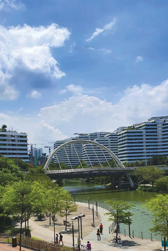
Cover photo: Demography
A sunny day in Punggol New Town.
Image courtesy of Elyssa Ludher. • Planning for Viable Commercial Centres and Retail 44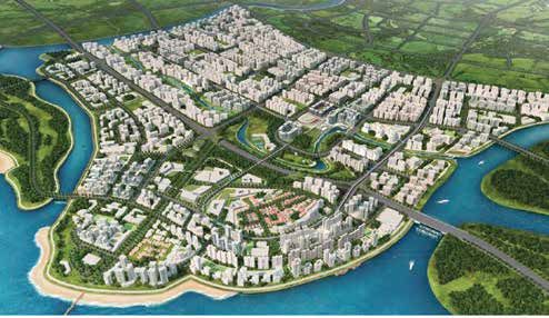
vi vii
• A Town Planned to Enhance “Kampung Spirit” Through 45 LIST OF ILLUSTRATIONS
AND EXHIBITS
Recreation and Greenery
• Excitement and Interest, Thwarted by the 1997 47
Asian Financial Crisis
CHAPTER 5 49 Illustrations
REJUVENATING PUNGGOL: BREATHING NEW LIFE
1. Punggol was home to many kampungs till the 1980s.
• Building Momentum for Better Things to Come 50 2. Changes in and around Punggol as captured by Landsat satellite imagery.
• The Trickle That Led to a River: The Launch of Punggol 21+ 53 3. Changes and refinements made on the master plan over the years.
• Master Planning and Urban Design: Keys to a Great Town 54 4. My Waterway@Punggol spurred a new master planning process that brought greenery and
Building Institutional Capacity to Respond to New Needs 58 recreation facilities closer to residents.
• Leveraging Talents: Involving the Private Sector 60 5. The introduction of the waterway resulted in a new master planning process, as shown by this
artist’s impression of Punggol.
• Developing a Town of Unique Identities 61
6. Punggol remained designated as “rural” under the 1971 Concept Plan, even though the
• Providing Community Facilities and Amenities 63 Koenigsberger’s Ring City Plan of 1963 had proposed it to have 100,000 residents.
• A Living Laboratory to Pursue Sustainable Green Living 67 7. Chicken and pig farms in Punggol during the 1970s and early 1980s.
• Infusing Warmth Into the Town, and a Sense of Ownership 70 8. Location of pig farming areas and the phases in which they were settled.
Punggol as an Inclusive Community 72 9. The Lorong Halus Dumping Ground was commissioned in 1970 and was one of only two sanitary
landfills in Singapore at that time.
• Building on Kampung Spirit With Civil Organisations 74
10. Punggol and Serangoon Reservoirs are the 16th and 17th reservoirs in Singapore.
Punggol: Uniting Hearts Beyond Its Borders Through Otters 76
11. An 18-m deep cut-off wall was buried to prevent leachate from the Lorong Halus Dumping
Ground from entering Serangoon Reservoir.
CHAPTER 6 79 12. The Lorong Halus Wetland is an ABC Waters project that uses bio-remediation efforts to clean
PUNGGOL: BEARING FRUIT AS A SMART AND the leachate from the former dumping ground.
SUSTAINABLE TOWN 13. A bio-remediation pond in the Lorong Halus Wetland.
• Layering on Frameworks for a More Liveable and 80 14. A total of 2.77 km2 of land was reclaimed in the 1980s to build up land stock for future housing
needs.
Sustainable Punggol
15. Punggol's shoreline changed over the years as a result of reclamation and conversion of Punggol
• Ensuring Greater Access and Connectivity 85 and Serangoon Rivers into reservoirs.
• From a Commuter Town to Self-Contained Town: Punggol 85 16. The Constellation Plan and new corridors, including the one towards Punggol.
Digital District 17. Punggol's MRT and road networks were planned as part of the 1991 Concept Plan and modified
over time.
• Putting People on Top: A Car-Lite Punggol Digital District 89
18. The “butterfly wings” of the LRT network was planned so that most residents live within 200 to
• Establishing a Smart and Sustainable Town Infrastructure From 91 400 m of an LRT station.
the Ground Up 19. Singapore's connectivity expanded as more townships and commercial centres emerged,
• Beyond Ones and Zeros: Smart Technology Delivering Real 93 including in and to Punggol.
Value in Smart Towns 20. Punggol 21 features three rivers—Punggol River, Serangoon River, and a third river being formed
by Coney Island and the mainland.
• Punggol: Paving the Way for the Future of Singapore’s Towns 94
21. Punggol was planned to feature a continuous waterfront promenade that would meet with the
A Resident’s Voice: Foo Ling Fang, Punggolian of 20 Years 96 new Punggol Marina.
• The Fruits of Punggol 97 22. Punggol MRT station was to be integrated with the Town Centre and commercial facilities, making
it more convenient for residents.
Post-script 100 23. Punggol introduced Common Greens, which are gathering and meeting places, into estates.
Coney Island was to be the Town’s regional park.
Timeline 102
24. The plan included six to eight recreation clubs to be run by SAFRA or the NTUC. Residents could
Endnotes 106 become members to enjoy the facilities.
Bibliography 113 25. The Punggol North Taskforce was a platform for agencies and grassroots leaders to work
Image Credits 117 together to address the needs of Punggol residents.
viii                                                                                                                                                                                                        ix

26. The old Punggol Road in the 1980s; the road was retained as part of the Punggol Heritage Trail.        54. Seamless integration between the JTC business park and SIT in the Punggol Digital District with
27. Punggol 21+ introduced a fourth, man-made waterway created by connecting Punggol and                       a common campus boulevard and sky bridges to foster interaction.
    Serangoon Rivers inland.                                                                               55. The Open Digital Platform allows the various smart technology components to communicate
28. Residents and the wider community were engaged to contribute ideas for the waterway.                       with each other.

29. Residents only need to take a short walk to the waterway to enjoy continuous public pathways           56. The Digital Twin mirrors Punggol’s live environment in a virtual platform, allowing for easy
    and the rest spots along it.                                                                               testbedding of new smart technologies.

30. The HDB’s comprehensive Sustainable Development Framework was drawn up to guide the                    57. Encouraging the activation of Punggol’s many recreational and public spaces is key to ensuring
    development of Punggol as an eco-town.                                                                     a vibrant and loveable town.

31. Waterway Terraces was the winning entry for the Punggol Waterfront Housing Design                      58. Punggol’s development journey was decades in the making but it is now a loveable and smart
    Competition for its distinctive terraced concept.                                                          eco-town.

32. Waterway View was designed based on the Undulating and Rustic sub-theme concept.
33. Matilda House before government acquisition and after conservation and integration as a                Exhibits
    clubhouse of A Treasure Trove condominium.
34. A number of unique bridges are located along the waterway, giving each section of the waterway         1. Various HDB design schemes in Punggol.
    a distinctive identity—Lorong Halus Bridge, Adventure Bridge, Punggol Jewel Bridge and Punggol
                                                                                                           2. Community facilities and amenities.
    Walk Arc Bridge.
35. Oasis Terraces, a new typology of community centres, provides an important space not only for
    recreation and sport, but also for community activities and events.
36. Punggol's famed seafood restaurants at Punggol Point were also retained and redeveloped to
    suit the growing crowds.
37. As the population increased, Punggol is now home to many regional facilities.
38. The UEM tool is able to simulate wind flow and irradiance patterns to aid design for maximising
    thermal comfort for residents; heat-sensitive community facilities are then located in shaded areas.
39. Treelodge@Punggol incorporated many sustainable innovations that were subsequently adopted
    in newer HDB precincts.
40. Bioswales with natural barriers were designed following the guidelines of the ABC Waters
    Programme.
41. The floating wetlands and mangroves, located along Punggol Waterway, contribute as natural
    water cleansers.
42. Punggol is famed for its many community events, such as the Racial and Religious Harmony
    Street Parade and Family Carnival.
43. The SEED@SIP site was developed into a social entrepreneurship space through the capital that
    was raised from social investors.
44. SEED runs leadership programmes and provides a platform for social entrepreneurs to set up
    businesses.
45. Residents are able to contribute to the maintenance of their homes by volunteering with the
    WWS, which keeps the various waterways of Punggol clean.
46. Otters are popular inhabitants in Punggol, attracted by its clean and green environment.
47. Some of the various “layers” that were applied on Punggol included accessibility, community
    spaces, distinctive districts, and green and blue recreational spaces.
48. Green corridors are created at the Punggol Northshore development to enhance ecological
    balance and connectivity with existing green areas.
49. Nature Ways have been established throughout Punggol on rooftops, in parks and along
    roadways.
50. The Punggol Digital District is one of the key employment and innovation nodes within the
    Northern Gateway, part of Singapore's long term planning initiatives to strengthen the economy.
51. The Punggol Digital District Master Plan featured greenways, solar roofs and 1 km2 of pedestrian-
    free zone on the ground level.
52. The Collaboration Loop is a physical manifestation of the “interwoven” nature in which the
    business park companies and SIT students are integrated.
53. Punggol’s new economic centre was designed with connectivity, integration and interaction in mind.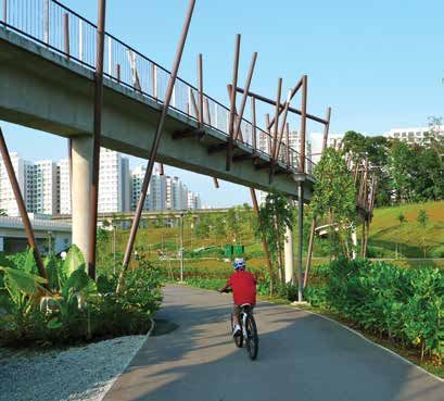
x                                                                              xi

    FOREWORD

    The global rise of cities has been unprecedented. It is estimated that every
    week, nearly 1.5 million people become urban dwellers. By 2050, the urban
    population will account for more than two-thirds of the world’s population.
    Such growth puts tremendous pressures on cities and many are unable
    to keep pace with the accompanying needs and demands. The shortfall
    and uneven access to infrastructure and, in particular, decent affordable
    housing have led to rising inequities, especially among the urban poor.
       For Singapore, the challenges are even greater, given that we are land
    and resource constrained. Our city-state strives to not only overcome
    our limitations, but to continuously push towards an improved quality
    environment and quality of life, to meet rising aspirations and expectations.
    Within the larger context of national development is the remarkable story
    of the public housing programme by the Housing & Development Board
    (HDB). Over six decades, the HDB has housed almost an entire nation
    in affordable public housing. Some 80% of the population now live in 26
    towns and estates, with the majority owning their own homes.
       This book chronicles the development of Punggol Town—the HDB’s first
    township that reflects its ambition to build a “sustainable” waterfront town,
    when “sustainability” was then still a relatively new concept to Singapore.
    The development of Punggol over the past two decades holds many
    lessons for us.
       First, it illustrated the need for a visionary plan with a long-term
    perspective. We must dare to dream, be innovative and take calculated
    risks when introducing new ideas. For example, Punggol Waterway was an
    innovation during its time, marrying functional needs with leisure needs,
    and it catalysed many new housing typologies that line the waterbody. It
    became the central iconic image that distinguished Punggol from other
    HDB towns. The trialling of sustainability initiatives at Treelodge@Punggol
    as a pilot project enabled the HDB to manage the risks, learn from them
    and eventually scale up such initiatives to many other towns. Punggol
    Northshore as the first smart and sustainable district is yet another
    experimental urban laboratory in the HDB’s learning journey.
       Second, for large townships that span some two to three decades to
    complete, disruptions are hardly unusual. At the same time, an extended
    timeframe often provides opportunities to harness new ideas and
    technologies as they become available. In the late 1990s, Punggol was
    affected by an economic downturn that caused the overall demand for
    housing to fall sharply. This slowed down the development of Punggol
    considerably, with impact on the building programme and infrastructure,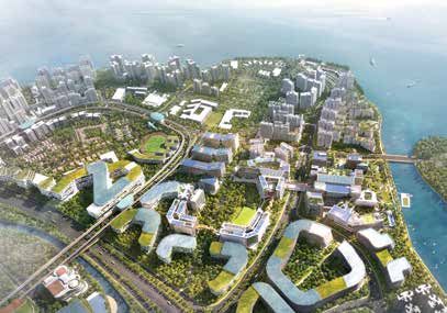
xii                                                                                                                                                     xiii

such as the light rail that was built in anticipation of demand. A decade
later, the second phase of Punggol’s development plans took on bolder
                                                                                PREFACE
moves with the adoption of new housing typologies, and more sustainable
and smart initiatives. Even as we kept our eyes on the longer-term vision,
we understood that plans can benefit from constant refinements and              The Centre for Liveable Cities’ research in urban systems unpacks the
therefore should be kept flexible to adapt to circumstances. Our approach       systematic components that make up the city of Singapore, capturing
to planning was a dynamic one.                                                  knowledge not only within each of these systems, but also the threads
    Third, aspirations and goals must be clearly defined and cascaded to        that link these systems and how they make sense as a whole. The studies
detail implementation. It is not enough to aim to be “sustainable” in a vague   are scoped to venture deep into the key domains identified under the
way. The HDB’s development of a clear Sustainability Framework helped           Singapore Liveability Framework, and attempt to answer two key questions:
it to set out the goals and measurable KPIs to be achieved, and to work         how Singapore transformed itself into a highly liveable city over the last
out detailed strategies and initiatives to hit these goals. These initiatives   five decades, and how Singapore can build on our urban development
must also be backed by science, using technology to attain and stretch          experience to create knowledge and urban solutions for current and future
the sustainability goals. This disciplined approach will ensure that Punggol    challenges relevant to Singapore and other cities through applied research.
moves towards being truly a sustainable town.                                   Punggol: From Farmland to Smart Eco-Town is the latest publication from
    Fourth, multi-stakeholder collaboration is essential to implement           the Urban Systems Studies (USS) series.
transformation strategies. Punggol’s successful implementation can be              The research process involves close and rigorous engagement of
attributed to the integrated efforts of government agencies, industry           our stakeholder agencies by the Centre’s researchers, and oral history
stakeholders and the active involvement of the community. The building          interviews with leaders and pioneers from Singapore’s urban sector, to
of townships, not unlike that of cities, is a complex affair. Building and      gain insights into development processes and distil tacit knowledge
strengthening the matrix of collaborative efforts generate a sense of           that has been gleaned from planning and implementation, as well as the
ownership among all stakeholders, enabling the harnessing of a wider slate      governance of Singapore. As a body of knowledge, the USS series, which
of ideas and resources, hence giving such large projects a greater chance       covers aspects such as water, transport, housing, industrial infrastructure
of success.                                                                     and sustainable environment, describes not only the visible outcomes of
    Punggol Town represents a significant milestone project for the HDB         Singapore’s development, but reveals the complex support structures of
and Singapore. Its successful implementation and the lessons learnt will        our urban achievements.
pave the way towards a more sustainable future for Singapore.                      In this book, we have sought to share how the actions of multiple
                                                                                agencies have coalesced in the development of Punggol as it evolved from
                                                                                a polluted part of our city to a dynamic and sustainable township, and more
Dr Cheong Koon Hean                                                             recently, to a smart town—a forerunner for future Singapore.
Chairman, Centre for Liveable Cities and                                           The Centre would like to thank all those who have contributed their
CEO, Housing & Development Board (2010–20)                                      knowledge, expertise and time to make this publication possible. I wish you
                                                                                an enjoyable read.

                                                                                Hugh Lim
                                                                                Executive Director
                                                                                Centre for Liveable Cities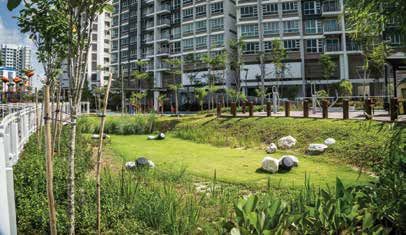
xiv                                                                              xv

      ACKNOWLEDGEMENTS

         The Centre for Liveable Cities is grateful to the following interviewees
      for their contributions (in alphabetical order): Chan Yoon Kum, Dr Cheong
      Koon Hean, Chew Men Leong, Dr Chong Fook Loong, Marjorie Chong,
      Fong Chun Wah, Foo Ling Fang, Eugene Heng, Michael Koh, Kong Yit San,
      Pebble Lee, Ryan Lee, Corrinne Lim, Loh Ah Tuan, Michelle Low, Penny Low,
      Ng Hwee Yian, Seow Kah Ping, Mohinder Singh, David Tan, Tan Sze Tiong,
      Jeffrey Teo, Wong Kai Yeng, Wong Mun Summ and Yap Kheng Guan. The
      Centre also would like to share its appreciation to the countless officers in
      the various agencies and organisations who contributed to the review to
      ensure the factual accuracy of this publication.
         The writer would also like to thank researchers Aloysius Teo, Xiao Chen
      Xu, Paul Niam and Grace Melissa Choi for their contributions to the book.
      This book is made possible with the patience and support of Gregory
      Lee, Brooklyn-media and Epigram. Lastly, the book could not have been
      completed without the guidance of Khoo Teng Chye, Dr Hee Limin and
      Michael Koh.
xvi                                                                                                                                                   xvii

THE SINGAPORE                                                              Integrated Master Planning and Development
LIVEABILITY FRAMEWORK                                                      Innovate Systematically
                                                                           The entire Punggol Town is an innovation in itself. From the outset, the
The Singapore Liveability Framework is derived from Singapore’s urban      town was a living laboratory that trialled early concepts of green and
development experience and is a useful guide for developing sustainable    sustainability solutions, smart technology and biophilic design. These were
and liveable cities. The general principles under the Integrated Master    done at the town, district and building levels. Within the Punggol Master
Planning and Development, and Dynamic Urban Governance are reflected       Plan, an area was set aside by the urban planners to pilot an innovative
in the themes found in Punggol: From Farmland to Smart Eco-Town.           district with a focus on digital technology and to bring about more
                                                                           employment opportunities for the north eastern region.
                                                                              To address the pain point of largely being a commuter town, the Punggol
                                                                           Digital District (PDD) was introduced as a town centre. It was designed to
                                                                           house industries in cybersecurity, smart living and smart-estate innovations.
                                                                           The Open Digital Platform (ODP) was established to provide a single
                                                                           platform for smart solutions. It also built in a Digital Twin, which provides
                                                                           a true-to-life 3D representation of the entire district, allowing for scenario
                                    High                                   simulations, testbedding of new technologies, and real-time monitoring.
                                   Quality                                 To ensure that the PDD continues as a hub for smart technologies,
                                   of Life                                 collaboration and sharing between academia, industry and enterprise are
                                                                           encouraged by design, for example, by co-locating the Singapore Institute
                                                                           of Technology with the JTC business park. See Chapters 4 (page 39), 5
                                                                           (page 49) and 6 (page 79).
                   Competitive            Sustainable
                    Economy               Environment                      Execute Effectively
                                                                           Prior to the 1990s, the rivers flanking Punggol were heavily polluted. As
                                                                           water security became increasingly urgent for Singapore, having Punggol
                                                                           and Serangoon Rivers as potable water sources became necessary. After
            Integrated Master Planning and Development
            •   Think Long Term
                                                                           the 1990s, the PUB, Singapore’s National Water Agency, methodically took
            •   Fight Productively                                         steps to clean the water by first phasing out key polluters, then dredging the
            •   Build in Flexibility
            •   Execute Effectively
                                                                           rivers of pollutants, addressing potential leachate from the decommissioned
            •   Innovate Systemically                                      Lorong Halus Dumping Ground, and finally cleaning and damming both
                               Dynamic Urban Governance                    rivers into reservoirs. Today, the Lorong Halus Dumping Ground has been
                               •   Lead with Vision and Pragmatism         redeveloped into a man-made wetland using bio- and phytoremediation
                               •   Build a Culture of Integrity
                               •   Cultivate Sound Institutions            techniques, while raw water from Punggol and Serangoon Rivers can be
                               •   Involve the Community as Stakeholders   abstracted for treatment in the NEWater plants. See Chapter 2 (page 13).
                               •   Work with Markets

                                                                           Dynamic Urban Governance
                                                                           Lead with Vision and Pragmatism
                                                                           Punggol was designated as a new township in the 1991 Concept Plan,
                                                                           as planners recognised the unique opportunities to create an attractive
                                                                           waterfront township. Dubbed Punggol 21, the township was planned as a
xviii 1
new typology, suited for the 21st century. As the Asian Financial Crisis began
in 1997, the development languished. Agencies then sought to revitalise the
OVERVIEW
space by introducing sustainable technologies, smart features and a fourth
waterway. This upgraded version was launched in 2007 as Punggol 21+. To Punggol is one of the newest townships in Singapore. Located on the
address the need for more local economic vibrancy, Punggol’s town centre north-eastern coast of Singapore and spanning just over 9 km2, the town is
was re-envisioned as the PDD in the 2010s. With that, Punggol would be home to 189,000 people.1 Expected to grow to 250,000 people by 2030,
a self-contained township. The successive improvements were a direct Punggol has a relatively young population, with the highest percentage of
result of leaders and agencies working together to address setbacks and children under five years of age in any town, at 9.9%.2
shortcomings. See Chapters 5 (page 49) and 6 (page 79). It has come a long way in the last 50 years. Once a fishing village, it was
home to a number of plantations and farms in the 1950s. While well known
Involve the Community as Stakeholders for its rustic nature, it had been the site of Singapore’s worst massacre, which
Involving the community as stakeholders is crucial in cultivating a sense took place during the Japanese Occupation. As Singapore industrialised,
of rootedness for a new town. Residents in Punggol were involved not Punggol became the site for many of the more pollutive industries,
only in the Punggol North Development Taskforce to plan its continued including sewage and water treatment plants, a dumping ground, charcoal
development, they were also involved in the hundreds of community trading and pig farms. Over time, this impacted the quality of its waterways
engagement events organised by the Housing & Development Board and and coast, leading to foul smells and concerns over the degradation of the
other government agencies for more than a decade. Residents continue to natural environment.
be actively involved in actions that promote cleanliness, biodiversity and
inclusivity, through not-for-profit or civic organisations such as Waterways
Watch Society, Social Innovation Park and OtterCity. These continued
community activities have cemented Punggol as being more than a town,
but a home. See page 70.
1. Punggol was home to many kampungs till the 1980s.
By the 1980s, Singapore’s rapid growth increased demand for new
residential communities. A new north-east corridor was planned, extending
to Punggol on the north-east coast.
However, in order to establish Punggol as a new residential community,
the issues caused by the presence of pollutive industries had to be
addressed. Over time, all pollutive industries and facilities were either
upgraded, relocated or phased out. This saw the end of certain industries
in Singapore such as pig farming as Punggol was the last remaining site for
pig farms. Following the departure or containment of pollutive industrial
activities in the area, a costly process of environmental remediation began.2 PUNGGOL: FROM FARMLAND TO SMART ECO-TOWN OVERVIEW 3
1988 1991 2002 2008 2013 2020
2. Changes in and around Punggol as captured by Landsat satellite imagery. The changing coastline
as a result of land reclamation, and other developments, such as the closure of the Lorong Halus
Dumping Ground and the damming of Punggol and Serangoon Rivers, can be seen clearly.
Extensive land and infrastructure works were also required before the Rather than leaving its subsequent development to chance, the HDB
development of housing could begin. Land was reclaimed to buttress the sought to reverse the downward trend. It re-envisioned Punggol under its
existing coastline, and add space for housing and recreation. Sewerage and Remaking Our Heartland initiative, relaunching it as “Punggol 21+” in 2007. A
drainage works were laid to accommodate the projected needs of the new key component of the initiative was to bring the water “closer” to residents
town with hundreds of thousands of new residents. The new north-east via a fourth waterway—the man-made My Waterway@Punggol. The new
MRT corridor was designed to ensure that Punggol residents had good waterway multiplied the available green space, and even introduced water-
access to other parts of Singapore via public transport. based sports close to home. The private sector was invited to participate
Punggol New Town, however, was not to be an ordinary Housing through design competitions that would integrate innovative features into
& Development Board (HDB) public housing estate. At the launching the landscape. The northern part of Punggol underwent another master
ceremony in 1996, then Prime Minister Goh Chok Tong highlighted that plan review process to optimise the recreational spaces afforded by the
Punggol was to set new standards in public housing design and planning. new waterway, as well as accommodate the new needs of the residents.
The plan was to “create a living environment that would appeal to a new
generation of better educated, more sophisticated Singaporeans” of 1998 2008
the 21st century.3 Dubbed “Punggol 21”, the town would “not just offer
well-designed HDB flats, but an integrated, high-quality environment of
LEGEND:
recreational and social facilities.”4
Residential
Among the innovations, each precinct would comprise 1,000 to 3,000
Civic and
dwelling units, instead of the 6,000 to 8,000 units in older public housing community
neighbourhoods. Dwellings in a precinct were to be clustered around its institution
own green lung, designed to encourage interaction among residents. Park
Most residents would be only 300 m away from a Light Rail Transit (LRT) Educational
2014 2019 institution
stop. Car parks were integrated into lower levels of the residential blocks,
Business park
unlike the open air or standalone car park blocks in other estates. The plan
Commercial
brought much excitement and interest when it was announced. and residential
The Asian Financial Crisis in 1997–98, and subsequently the slowdown Open space
caused by the severe acute respiratory syndrome (SARS) in 2003, Waterbody
however, had a deleterious effect on the development of Punggol. Sales Reserve site
of housing slowed, and this led to delayed delivery of planned amenities.
Road
Residents had to commute well beyond its borders for work, shops and
Sports and
facilities. Underdeveloped transport networks led to congestion. Punggol recreation
languished as a new town, a far cry from the vision residents had been 3. Changes and refinements made on the master plan over the years.
looking forward to.4 PUNGGOL: FROM FARMLAND TO SMART ECO-TOWN OVERVIEW 5
5. The introduction of the waterway resulted in a new master planning process, as shown by this
4. My Waterway@Punggol spurred a new master planning process that brought greenery and artist’s impression of Punggol.
recreation facilities closer to residents.
In 2012, Punggol was conceptualised as part of the larger master plan
In 2010, 14 years after Punggol 21 was first launched, it was designated to be a Creative Cluster and Learning Corridor, which eventually led to
an eco-town at the HDB’s 50th anniversary. New frameworks were layered Punggol Town being designated as the Punggol Digital District (PDD), to
onto the town, including the Sustainable Development Framework, Smart cater to industries in the digital space. Singapore Institute of Technology
HDB Town Framework, and Biophilic Town Framework. Each of these was invited to set up its new campus there, and was designed to integrate
layers brought about new programmes and solutions that enhanced the seamlessly with a planned JTC business park. JTC Corporation, the
environment, resulting in a greater infusion of nature into the town— designated master planner of the PDD, also introduced several new smart
both on the ground and vertically. A comprehensive network of cycle infrastructures; one major inclusion was the locally developed Open Digital
and pedestrian paths was built into the town to encourage more active Platform (ODP). The ODP would allow more efficient integration with
lifestyles. As the population grew, there was rejuvenation in activities to smart technologies. These new technologies were adopted with an eye on
develop more amenities and community facilities. the future, where they could be deployed in other parts of Singapore. As
Punggol was also selected to be a testbed for new ideas and technologies such, Punggol was designated a “Strategic National Project”, an important
for sustainable development and to create a greener living environment. It component in achieving Singapore’s Smart Nation vision, which had been
became a living laboratory, where Urban Environmental Modelling (UEM) earlier announced in 2014.
was used to simulate wind flow and solar irradiance patterns and drive Today, Punggol is a highly sought-after address—green, bustling and
building designs that would maximise thermal comfort for residents. vibrant. The journey has not been an easy one. As with any grand, new
Active, Beautiful, Clean Waters (ABC Waters) design principles were urban development, it suffered its fair share of setbacks presented by the
applied to integrate water-retentive green spaces around residential need for site remediation, the impacts of successive economic slowdowns,
buildings. Photovoltaic (PV) solar panels were deployed from the start, and a lack of timely infrastructure and amenities in its initial years. The keys
both on buildings and water surfaces. A unique identity was created for to its success have been the persistence of a long-term vision, effective
each precinct to foster community affinity for their new homes. Civil planning, interagency collaboration, innovation and built-in provisions for
organisations were set up to facilitate greater involvement from residents flexibility. This journey—with its challenges and the efforts to systematically
in the betterment of their communities and further strengthen their pride overcome them—is documented in this Urban System Study on Punggol,
of place. which chronicles the complex nature of new town building, from pitfalls to
opportunities, so that others may learn from it.CHAPTER 1
PUNGGOL
THE FARMING
HINTERLAND
Punggol, also spelt Ponggol, means ‘hurling
sticks’—a method of bringing down fruits off
fruit trees—in Malay. This indicates that Ponggol
was a renowned fruit-growing district.5
NATIONAL HERITAGE BOARD8 PUNGGOL: FROM FARMLAND TO SMART ECO-TOWN CHAPTER 1 9
Punggol, located in the north-east of Singapore and sheltered by the
Johor Strait and Pulau Ubin, is one of the oldest settlements in Singapore.
It has been continuously inhabited for at least 400 years, housing fishing
and trading communities; many planted vegetables and fruit trees for
sustenance.6
By the mid-20th century, Punggol was mainly covered in rubber
plantations.7 Its coasts were used extensively for recreation and fishing; it
was a popular spot for seafood, boating and water sports.8 Punggol was also
home to Singapore’s first two zoos.9 In the dark days of the Second World
War, it was one of the sites of the Sook Ching Massacre, where 400 Chinese
civilians were killed by the Japanese military forces; the site is now a national
heritage site. Post-war, from the 1950s to the 1970s, Punggol was dominated
by vegetable, chicken, duck, fish and pig farms, as well as plantations.
Punggol’s potential as a township was recognised early on. It was
proposed that Punggol house 100,000 residents under the Koenigsberger’s
Ring City Plan of 1963; however, Punggol remained a rural designation
under the 1971 Concept Plan. Up to the late 1980s Punggol was populated
with farmlands that had few access roads.
7. Chicken (top) and pig (bottom) farms in Punggol during the 1970s and early 1980s. The latter
featured automated feeding machinery and best practice waste management systems for that time.
Of all the farming types, pig farming was among the most lucrative,
due to the growing demand for pork as a protein source for Singapore’s
growing middle class.
In the mid to late-1970s, the government decided to consolidate all pig
farms from the various parts of Singapore to Punggol and the neighbouring
Jalan Kayu. This was to clear pollutive industries and activities from
identified water catchment areas, such as in Kranji, to safeguard water
quality for human consumption, as well as control odours that impacted
6. Punggol liveability. Punggol, which was at that time outside of designated potable
remained water catchments, was thus designated an intensive pig farming area for
designated as a 30-year period.10 The consolidation was implemented in three phases:
“rural” under the
Punggol Phase 1 Pig Farming Area (2.08 km2) (1974), Punggol Phase 2 Pig
1971 Concept
Plan (bottom), Farming Area (2.53 km2) (1975), and Punggol Phase 3 Pig Farming Area
even though the (1.89 km2) (1981).11
Koenigsberger’s The pig industry grew rapidly. By 1975, it was worth S$249 million,12
Ring City Plan of
making it one of the most important and profitable economic activities in
1963 (top) had
proposed it to have Singapore.
100,000 residents.10 PUNGGOL: FROM FARMLAND TO SMART ECO-TOWN CHAPTER 1 11
FARMS NEED PLANNING TOO!
PHASING IN OF PIG FARMS
As big and small pig farms were relocated to Punggol from all over number of complaints was exposure—new farms could be seen easily from
Singapore, the limited space needed to be maximised and efficiently the road, whereas old farms were out of sight. To address this, the Primary
allocated. Thus, land was released in phases. Production Department planted fast-growing shrubs and trees along the
full length of roads bordering the pig farming area to reduce sightlines.
The authorities learnt from the challenges of the Jalan Kayu farms, and
applied the lessons to Phase 3, located on the eastern side of Punggol.
The third phase was more akin to an industrial parkland for pig farming.
Thick belts of trees were planted on both sides of the farmways and along
the public highway to buffer the surrounding residential areas as a way to
reduce complaints and disperse smell trajectories.
8. Location of pig farming areas and the phases in which they were settled.
The first phase was developed in 1974 with minimal earthworks. Roads
were not paved until a few years later, but concrete drains were installed
to carry both rain runoff and farm effluent. Incoming farmers carried out
their own earthworks at the farm lots before erecting their pig barns and
family dwellings. It was planned with small lots to encourage family farms,
but commercial pig farming was available on long-term leases. Farmers
intensified usage of land with little regard for proper farm layout, sanitation
or aesthetics. Farms were built on a 1% slope for waste removal by flushing.
The second phase was largely in the Jalan Kayu area, to the west of
Punggol. Pigs started arriving in May 1977. Small farms were given temporary
occupation licenses and farmers were obligated to renew their licenses
periodically. These farmers also brought with them traditional practices,
including old building materials and barns, and maintained previous
housekeeping and husbandry practices. In October 1977, residents nearby
lodged complaints about pig odours although the Standing Pig Population
(SPP) had increased by only 1,000. One of the reasons for the greaterCHAPTER 2
REHABILITATING
PUNGGOL
In the 1970s, there was a direction to keep
Punggol as an area for pollutive industries
and dirty activities, given its relatively
rural and inaccessible nature. The Punggol
area [stank] heavily due to the pig farms
discharging untreated waste directly into the
river, and it is amazing that Punggol River can
be turned into a drinking reservoir now.13
WONG KAI YENG
Director of Planning and Policies,
Urban Redevelopment Authority (1994–96)14 PUNGGOL: FROM FARMLAND TO SMART ECO-TOWN CHAPTER 2 15
As Singapore’s population grew over time, more space was needed for
housing and industry. Areas in the north-east, including Punggol, were
reconsidered for urbanisation and development.
Shifting Out Pollutive Industries
and Activities
Aside from pig farms, due to the relatively rural locations, catchments
of Punggol and Serangoon Rivers housed many “pollutive” activities.
Serangoon River received the discharge of treated effluent from the
Kim Chuan Water Reclamation Plant (originally the Kim Chuan Sewage
Treatment Works) built in 1948.14 The plant treated up to 282,000 m3
per day at its peak, treating sewage from areas east of Bukit Timah and
the eastern parts of the island.15 The neighbouring Paya Lebar/Defu area
(formerly Teck Hock Industrial Estate) was also known for its pollutive
backyard industries, being designated by the government to house
aluminium processing, furniture making, motor works, and food processing
activities.16 Contaminated runoff from these industries were flushed into
Serangoon River. As one research paper described:
A substantial amount of pollution was observed along the length
of the [Serangoon] river, with refuse accumulating in several
locations on the banks of the river…The stench of hydrogen sulphide
was apparent throughout the length of the river and gas bubbles
could be seen rising to the surface of the water. This was especially
pronounced in the middle reaches of the river but improved nearer
the mouth of the river.17
Another major polluter near Punggol was the 2.34-km2 Lorong Halus
Dumping Ground that was established in 1970 and built on the banks 9. The Lorong Halus Dumping Ground was commissioned in 1970 and was one of only two
of Serangoon River at the site of the former Municipal Sludge Disposal sanitary landfills in Singapore at that time.
Works. The Dumping Ground was also the location at which night soil was
buried.18 Loh Ah Tuan, Deputy CEO, National Environment Agency (NEA) By 1982, almost half of the waste generated from domestic premises in
(2004–07), explained the siting of a dumping ground in Lorong Halus: Singapore was disposed of at the Lorong Halus Dumping Ground, further
contributing to the noxious odours in Singapore’s north-east region.
When Lim Chu Kang landfill, the only landfill then in the western part
of Singapore, was running out of capacity to dispose of waste, it was
decided [that] a new landfill would be built at Lorong Halus in the
east. Also, the site at Lorong Halus was a swampy area, which could
be used for disposing waste.1916 PUNGGOL: FROM FARMLAND TO SMART ECO-TOWN CHAPTER 2 17
Making the Tough Decisions:
Phasing Out Pig Farms NO PLACE FOR PIGS
By the 1980s and 1990s, more residents were moving into the region.
Malodours from the combined waste streams, and its flotsam, resulted By the early 1980s, the stocking density of pigs was as high as 2,000 pigs
in regular complaints. Yap Kheng Guan, Director of Drainage, PUB (1992– per hectare. As malodorous smells could travel as far as 900 m, farms were
2001), recalled that: thus required to be sited greater than 1,000 m away from the residential
areas, which by 1983, was impossible in the remaining non-water catchment
The Drainage Department would receive complaints of the smell, areas.21
especially during periods of low tides and north-easterly winds, from There were many considerations on removing the pig farms, including
residents of Seletar Hill.20 the need for land for more housing and industrial estates, its negative
impact on the water quality, its noxious smells, public health, and even the
At a national level, the planning department was tasked to address concerns of neighbouring Malaysia due to the sensitivity of pork waste in
the placement of waste, water treatment, food production and economic shared waters. This was argued against concerns for the desire for local
activity even as environmental regulation increased. It could no longer leave food security and preference for fresh pork, as frozen pork was not widely
Punggol as it was: accumulating more and more pollutive industries and accepted.22 Eventually, an argument was made that pork could be imported
infrastructure. Action had to be taken to reduce the contaminating elements. from surrounding nations. Loh Ah Tuan, then Deputy CEO of the NEA, had
To address the increasing pig waste, the Primary Production Department, a more singular focus on the matter:
under the Ministry of National Development, was tasked to introduce
modern husbandry practices and install proper waste management The issue was Pork versus Water. The decision was obvious—water.
facilities. In 1979, a decision was taken to set up waste treatment plants in Pig farms, therefore, had to go.23
all pig farms to reduce environmental pollution. In early 1980, an abattoir
levy was charged on every pig to fund the construction of high-quality In 1984, a decision was made to phase out the pig farms in Singapore.
pig waste treatment facilities. Various initiatives were also undertaken to This was a blow to many in the industry and government agencies; many
mitigate pollution, including experiments with high-rise pig farms, which farmers had moved to Punggol after being assured that they could keep
ultimately proved to be unsuccessful. their livelihoods. To aid the process of phasing out pig farms, pig farmers
Eventually, however, the decision was made to remove pig farms were compensated; many turned to other types of farming or businesses.
completely (see Box Story). By 1989, all pig farms were phased out.
Fortunately for Singapore, importing pork had become more viable by
that time. The neighbouring countries had agriculture-based economies
and were keen to develop an export market to Singapore for meat,
vegetables and poultry products.
In 1986, Punggol was designated for future housing and non-pollutive
farming was allowed to continue only on temporary leases. This was
firmed up in the 1991 Concept Plan when Punggol was zoned largely for
residential use.18 PUNGGOL: FROM FARMLAND TO SMART ECO-TOWN CHAPTER 2 19
From Foul to Potable Water: Cleaning up After the Singapore River was cleaned up in 1987, PM Lee would
Serangoon and Punggol Rivers ask [Chairman of the PUB] Lee Ek Tiang every few years about the
feasibility of Marina water for potable water supply.31
Singapore’s water security is an issue of survival. Before independence, Eventually, with the advent of NEWater, Singapore looked into
Singapore’s water was mainly sourced from Malaysia, based on two Water increasing its local water supply by creating more reservoirs besides Marina
Agreements with the government of the State of Johor in Malaysia. The first Reservoir—PUB, Singapore’s National Water Agency, studied the possibility
Water Agreement was signed in 1961, which granted Singapore the full and of damming up Punggol and Serangoon Rivers to impound the surface
exclusive rights and liberty to draw off, take, impound and use all the water runoff for water supply even though they were marginalised catchments.
within the catchment areas of Gunung Pulai and Pontian, and the Tebrau However, due to the presence of pollutive industries within these catchment
and Skudai Rivers, until 31 August 2011.24 Following its lapse, Singapore areas, damming up the river mouths would only trap the pollutive runoff, as
handed back the waterworks to Johor.25 The second Water Agreement well as obnoxious leachate from the Lorong Halus Dumping Ground.32 That
was signed in 1962, which grants Singapore the full and exclusive right area was so polluted that some thought it was impossible. Then CEO of the
and liberty to draw off, take, impound and use the water from the Johor PUB, Khoo Teng Chye, recalled Tan Gee Paw, Chairman of the PUB, saying
River up to a maximum of 250 million gallons per day until 28 September to him, “I hope you’re not mad enough to dam up the Serangoon River.”33
2061.26 In return, Johor is entitled to a daily supply of treated water from However, for Singapore’s water survival, it had to be attempted. Agencies
Singapore not exceeding 2% of the total quantity of water supplied to had to work hard to “clean” the catchment to reduce pollution over time.
Singapore on any given day. The two Water Agreements were guaranteed Both Punggol and Serangoon Rivers were dredged to remove contaminated
by both the governments of Malaysia and Singapore under the 1965 and nutrient-rich organic sediments to prevent the continuous release of
Separation Agreement, which was deposited with the United Nations.27 sediment-bound nutrients and pollutive contaminants.34
Notwithstanding the Water Agreements being enshrined in the As Chan further recalls:
Separation Agreement, then Prime Minister (PM) Lee Kuan Yew recounted
that Tunku Abdul Rahman, Malaysia’s first PM, had said to the British High Mr Tan Gee Paw took over as Chairman of the PUB in 2001 and
Commissioner in Kuala Lumpur, “If Singapore doesn’t do what I want, I’ll pushed for the creation of more reservoirs, which tantamounted to
switch off the water supply.”28 retrofitting of catchments for drinking water supply. Agencies [had
As such, PM Lee took it as a priority to ensure Singapore’s water to prepare] a “negative list” so that for any catchments, if there were
security. He shared: “Every other policy had to bend at the knees for activities/developments in the negative list, they must be gotten rid
our water survival….”29 In 1971, the Water Planning Unit was set up and of, so to speak, or relocated. If they are not [on] the negative list, we
placed under the Prime Minister’s Office and was highly influential in can try to make do and live with that.35
deciding various factors of Singapore’s development. In 1972, the Unit
had drawn up its first Water Master Plan, which evolved into today’s Yap remembers the works that were carried out:
“Four National Taps”.
The whole country was evaluated to capture and harness every drop of After the pig farms were phased out and Lorong Halus
rainwater. PM Lee exhorted that “[it] should be a way of life to keep the decommissioned, massive dredging works [began on] Serangoon
water clean, to keep every stream, every culvert, every rivulet free from River, [where the] first round between 2001 and 2002 took care of
unnecessary pollution.”30 The 1972 Water Master Plan earmarked water smells from tidal flats during low tides. In Punggol River, between 1999
catchments to be developed in order to maximise the yield from surface and 2002, dredging work was also conducted, and river alignment
water sources to boost the drinking water supply in Singapore. In 1977, and embankment strengthening too.36
when PM Lee opened Upper Peirce Reservoir, he challenged the Ministry
of the Environment (ENV) to clean up the Singapore River in 10 years. Eventually, in 2011, Punggol and Serangoon Rivers were both dammed
The Singapore River was cleaned up by 1987. Chan Yoon Kum, Director of to create Singapore’s 16th and 17th reservoirs respectively. The two
Water Department, ENV (1995–2004) recalled: reservoirs are connected via My Waterway@Punggol (see Chapter 5).20 PUNGGOL: FROM FARMLAND TO SMART ECO-TOWN CHAPTER 2 21
Punggol and Serangoon Reservoirs were officially opened on 3 July 2011.37
The water quality of both reservoirs has improved over the years; water ESTABLISHING DATA FOR A
from Serangoon Reservoir can now be blended with water from Punggol SYSTEMS-BASED APPROACH TO WATER
Reservoir and abstracted for drinking.38
Wong Kai Yeng, Director of Planning and Policies, URA (1994–96), adds:
Part of the strategy to ensure water was collected in reservoirs was by
Punggol offered two important lessons—first, cleaning up a polluted damming rivers to create large bodies of freshwater over time. However,
area is not going to be easy or cheap; second, Punggol has shown in the 1970s, there was little data, and certainly not enough to create
that this can be done.39 models to understand the hydrological systems. While topographical and
meteorological data existed, these were not available in a format that “talked”
to each other. Tan Gee Paw, Chairman of the PUB (2001–17), explains:
In those days there were no powerful computers to do simulations.
[The team had to do everything on its own.] I was thankful we had
a computer in the PUB, a huge computer that occupied the whole
room which was meant to print all the PUB bills. We had to start
from scratch, and it took about two years. I remember asking the
guy in charge of it, Lau Ping Sum, for permission to use it. He said
yes without knowing I did not know a thing about computers! It was
most challenging; and we worked late into the night, reading manuals
on how to programme the computer and when we finally figured it
out, we used it to start simulating rain runoff so we could see what
happened in extreme events, and calculate the water yield in certain
catchments. That is how our first water plan came to be.40
Beyond MacRitchie, Peirce and Seletar Reservoirs, which were developed
many decades before, the new dams created are Kranji, Pandan, Murai,
Poyan, Tengeh, Sarimbun, and Lower Seletar Reservoirs.
10. Punggol and Serangoon Reservoirs (above and below respectively) are the 16th and 17th
reservoirs in Singapore.22 PUNGGOL: FROM FARMLAND TO SMART ECO-TOWN CHAPTER 2 23
INNOVATING SYSTEMATICALLY: Stormwater Catchment of Punggol–Serangoon”. The paper captured
URBAN CATCHMENTS the very spirit of what we did successfully in Bedok.43
With the successful implementation of Bedok Reservoir, which collects
Typically, water catchments are designated in pristine, protected areas stormwater runoff from an urbanised catchment, a similar stormwater
with low population densities. This is not possible for Singapore as land is collection scheme was planned in the late 1990s for Hougang, Sengkang
scarce. However, to reduce water contaminants, an urbanisation catchment and Punggol new towns. Given that the Punggol and Serangoon catchment
policy was introduced in 1983 to cap the density of housing in catchment areas are largely zoned for residential developments, stormwater runoff
areas to 34.1% and/or 196 dwelling units per hectare. from these cleaner areas can be tapped for potable water supply before
The PUB sought to prove that urban catchments, if properly managed, they flow into the rivers. Nonetheless, although the PUB was exploring
could maintain acceptable levels of water quality even with higher housing the option for a selective stormwater collection system, they never lost
densities. They selected nine urban catchment areas located in Bedok, sight of eventually transforming Punggol and Serangoon Rivers into
Tampines and Yan Kit, which fed into Bedok Reservoir through holding reservoirs. This was made possible by progress made on two key fronts:
ponds and pumping stations, to demonstrate that the contamination levels (1) developments in pollution control and (2) advancement in water
of runoff within an urbanised environment were within acceptable ranges.41 treatment technology.
The Sungei Seletar–Bedok Water Scheme, which was completed in 1986,
was the first urban catchment where the stormwater collection system was Developments in Pollution Control
specially designed to allow the more polluted dry weather flow and the • With the completion of the Deep Tunnel Sewerage System (DTSS)
“first flush” of the wet weather flow to bypass the collection facility, while Phase 1 project in 2008, the Kim Chuan Sewage Treatment Works
the cleaner part of the stormwater runoff was diverted into a holding pond (which had treated effluent discharged into Serangoon River) and
and pumped into Bedok Reservoir.42 Serangoon Sludge Treatment Works were decommissioned, thus
Chan Yoon Kum, Director of Water Department, ENV (1995–2004), removing two major sources of pollution.
recounts the journey: • The development of Punggol as a residential town (Punggol 21)
provided a compatible land use as an urban water catchment.
When we [first] did the Sungei Seletar–Bedok urbanised catchment • The PUB imposed strict anti-pollution requirements and stepped up
water scheme, we were also told we were crazy by the Americans checks to ensure proper housekeeping in Defu Industrial Estate.
to tap stormwater runoff from urbanised catchments for drinking • A “Negative List” was established in 2005, which barred the setup of
water supply; CDM [an American engineering and construction pollutive industrial activities in water catchment areas and facilitated
company] had won the award in the United States for this water the relocation of any activities in this list out of water catchments.
scheme as the consultants. • A sewer rehabilitation scheme in Punggol–Serangoon was carried
out from 2009 to 2011 at the cost of S$57.9 million.
After 12 years of urbanised catchment, CDM was engaged to do a full
study on the water quality. We actually found that urbanised water Advancement in Water Treatment Technology
quality was not bad! Because of this finding, a paper was put up to • The advancement in membrane technology enabled the runoff from
the Cabinet in 1999 to lift the catchment policy cap. the full catchments of Punggol and Serangoon to be considered for
water supply.
Moreover, because of this, Punggol was able to be developed at a
plot ratio of 3.4, allowing it to be the vibrant town that it is today. The completion of urban reservoirs such as Punggol, Serangoon and
Marina Reservoirs enabled Singapore’s water catchment area to increase
We cannot look at Punggol and Serangoon in [a] vacuum. After from half to two-thirds of the total land area, making Singapore one of the
the PUB developed the Sungei Seletar–Bedok Water Scheme few countries in the world to harvest urban stormwater on a large scale for
successfully, we submitted a paper to the Cabinet, for “Selective potable consumption.You can also read