Europe's Vibrant New Low Car(bon) Communities - Nicole Foletta and Simon Field Summer 2011
←
→
Page content transcription
If your browser does not render page correctly, please read the page content below
Institute for Transportation
 & Development Policy

Europe’s Vibrant New
Low Car(bon) Communities
Nicole Foletta and Simon Field
Summer 2011

Executive Summary               5

                                             case studies

                                             Greenwich Millennium Village    8

                                             GWL Terrein                    18

                                             Hammarby Sjöstad               30

                                             Houten                         46

                                             Sihlcity                       60

                                             Stellwerk 60                   70

                                             Västra Hamnen                  82

                                             Vauban                         94

This report was researched and written by
                                             conclusion
Nicole Foletta and Simon Field in 2010.
It was edited by Dani Simons. Many thanks    Comparative Analysis           107
to Walter Hook, Luc Nadal and Michael
Kodranksy for their reviews and revisions.
Cover photo from La-Citta-Vita on Flickr.    Lessons Learned                113
building low car(bon) communities

Executive Summary

Moving is a time to reevaluate the stuff you own. Boxes of family
photos? Coming. That ratty old couch? Not coming. But what if you            principles for smart urban growth
could leave something even bigger behind? Like your car?
    New developments are often associated with sprawl and more
driving. But eight communities across Europe demonstrate there is a
different model. ITDP Europe investigated these developments and                1. Walk: Develop neighborhoods that promote
found by using smart urban and transportation planning and design,                   walking
they have created communities with lower car ownership rates and                2. Cycle: Prioritize bicycle networks
less driving than nearby developments of comparable sizes and age.              3. Connect: Create dense networks of streets
As a result these communities have less pollution, greenhouse gas                    and paths
emissions, public health issues and other negative externalities                4. Transit: Support high-quality transit
associated with driving.                                                        5. Mix: Plan for mixed use
    These new developments use a combination of “push” measures                 6. Densify: Match density with transit capacity
to discourage private car use and “pull” measures to improve                    7. Compact: Create compact regions with
the attractiveness of walking, cycling, transit and various forms                    short commutes
of shared vehicle use. As the report demonstrates, these measures               8. Shift: Increase mobility by regulating
work, and could be applied in other new developments around                          parking and local road use
the world, particularly in abandoned industrial sites or on other
previously developed land.                                                     Developed by a team of urban design experts
    The eight case study locations are summarized in Table 1.                  including ITDP, Gehl Architects, Nelson Nygraard,
    Eventually these measures should be applied to all urban devel-            and Calthorpe Associates
opment, in order to minimize the need for driving and maximize the
opportunities for healthier, more sustainable forms of transporta-
tion. Therefore ITDP presents these case studies, identifies lessons
learned and compares the planning, design and travel demand
management techniques used so that others might follow the lead          then presented, based on the literature and/or surveys developed by
of these eight communities.                                              ITDP Europe, followed by a summary of lessons learned and recom-
    Each case study includes background information on the origins       mendations for further research.
of the development and how these best practices were incorporated           It is worth noting that the most successful “car-free” and largely
at early stages of the developments’ planning processes, before          “parking-free” developments reviewed had well-organized grass-
describing individual measures in more detail. Quantitative data on      roots support for the concept from the outset. Planners and decision
vehicle ownership, modal split and transport-related emissions are       makers should look for willing partners as they undertake these

Table 1: Case study locations

                                                                                                      Size
   Development                        Location               Type
                                                                                                      (hectares)

   Greenwich Millennium Village       London,                Brownfield: mixed use, car-reduced        29
                                      United Kingdom

   GWL Terrein                        Amsterdam,             Brownfield: residential, car-free         6
                                      The Netherlands

   Hammarby Sjöstad                   Stockholm, Sweden      Brownfield: mixed use                     160

   Houten                             Utrecht,               Greenfield “cycling city” of 45,000        820
                                      The Netherlands        people

   Sihlcity                           Zurich, Switzerland    Brownfield: leisure and retail            4

   Stellwerk 60                       Cologne, Germany       Brownfield: residential, car-free         6

   Västra Hamnen                      Malmö, Sweden          Brownfield: mixed use                     175

   Vauban                             Freiburg, Germany      Brownfield: mixed use, car-reduced        41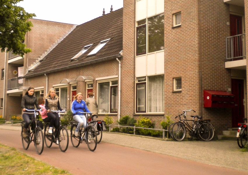
6    Europe’s Vibrant New Low Car(bon) Communities                                                                                                                                                                                                                                      Executive Summary      7

endeavors. And they should foster community participation to build                 transit, living car-free becomes more realistic. Many developments        5. Market sustainable transportation.                                          In summary, it was found that private car use accounts for less
support as the project evolves, and to ensure the endurance of the                 also provide nearby carsharing locations to help residents feel more      Many of these developments make ongoing efforts to reinforce their         than 35% of all trips made by residents in all of the sites (Stellwerk 60
vision for the development once it is built.                                       comfortable giving up their private cars.                                 founding vision and to empower residents and visitors to make sus-         result inferred from distance-based data), a figure that is generally
    The top lessons learned from these case studies closely align                                                                                            tainable travel decisions by offering tailored mobility advice, running    lower than comparable sites without integrated TDM strategies.
with the Principles for Transport in Urban Life, and are as follows:               3. Create compact regions with short commutes and zone new                                                                                          Car ownership was found to be no more than 440 vehicles per 1,000
                                                                                                                                                             marketing and awareness campaigns, and through promotions such
                                                                                      developments for mixed use.                                                                                                                       residents in the residential developments, and less than 200 in sites
                                                                                                                                                             as free or discounted transit passes or car-sharing membership for
1. Develop neighborhoods for walking and prioritize bicycling                     These case studies also suggest that new developments should                                                                                         with priced, limited and spatially separated parking: GWL Terrein,
                                                                                                                                                             new residents. Ongoing measures to encourage low-emission travel
   networks.                                                                       be planned as closely as possible to existing job centers and other                                                                                  Stellwerk 60 and Vauban. These sites generate less than 350 kg
                                                                                                                                                             behavior are important to ensure the long-term transport sustain-
The majority of developments in the case studies provide direct, safe              destinations. This makes investments in transit and cycling networks      ability of residents. Planners should consider whether the developers      of car-related CO2 per capita per annum, equivalent to savings of
and comfortable walking and cycling routes, and plentiful covered                  more efficient and effective. Mixed uses (housing, jobs, leisure          should be asked to fund these initiatives or if there are ways to create   around two thirds compared with their reference areas. These figures
cycle parking. They also use a technique called “filtered permability”             facilities, shops, grocery stores, etc.) should be incorporated into      dedicated streams of revenue (e.g. by earmarking a portion of parking      demonstrate both the efficacy of TDM measures and the importance
to make travel by bicycle or foot more direct than by car (Table 2), and           new developments at site selection and masterplanning stage, to           fees or outdoor advertising fees/space) to fund them over time.            of building in the right location, close to centers of existing economic
locate bicycle parking closer to homes than car parking. This gives                minimize travel distances, enabling residents to make routine trips                                                                                  and social activity.
walking and cycling a competitive advantage over the car. Some are                 on foot or by bicycle, with convenient public transportation offering a   6. Don’t forget the larger policy context.
beginning to use bike sharing to encourage occasional bike use by                  realistic alternative to the car.                                                                                                                    Further Research Needs
                                                                                                                                                             Transportation policies at the city, regional and national levels play
visitors and residents alike.                                                                                                                                a key role in shaping daily travel behavior and residential locations      Further household research should be conducted to update the case
    These developments are built with pedestrians and cyclists in                  4. Increase mobility by regulating parking and road use.                                                                                             studies as necessary and to add to the evidence base justifying the
                                                                                                                                                             in the longer-term. Congestion charges, citywide parking manage-
mind; dense networks of streets allow pedestrians and cyclists to                  In addition to the nudges the urban design of these communities           ment policies, high fuel prices, and high quality transit all influence    implementation of these policies and practices in Western Europe
pass, even where cars cannot (filtered permeability). This design is               provide, many also use regulations to incentivize and in some cases       mode choice, reinforcing site-specific measures such as car-access         and in new developments around the globe. Additional quantitative
reinforced with low speed limits and traffic calming. By making car                mandate reduced car use, using a variety of techniques including          restrictions, provision of high quality walking and cycling facilities     research is required to assess both the demand for car-free living
use less convenient than other modes, residents are subtly nudged                  placing stringent caps on car trip generation and CO2 emissions and       and filtered permeability. All of the case study cities are served by      and the financial performance — in terms of rental and property
to consider other modes.                                                           relaxing parking minimums if other criteria to reduce car demand are      national railroad systems, providing an alternative to the car for         prices — of heavily car-reduced and car-free areas. This would
                                                                                   met. In many of the cases, parking supply has been reduced and the        longer-distance journeys, thereby complementing measures to                encourage local authorities, planners, investors and developers to
2. Provide high-quality transit.                                                   parking that does exist is separated spatially and fiscally from hous-                                                                               be more pro-active in considering this type of development, which
                                                                                                                                                             discourage car ownership and use in the local area.
The transport in all of the case study areas is responsive to resident             ing units. In some cases the planners have also required developers           A comparative analysis is presented in chapter ten, providing an       has been shown to reduce car dependence and transport-related CO2
needs, and therefore has high mode share. Stops are within half a                  to fund or build transportation infrastructure and services (includ-      overview of TDM measures, details of transit provision and urban           emissions significantly. Many of the lessons learned are replicable
kilometer of every home, and service frequencies are at least every 15             ing mobility management services) as a condition of site approval.        design features, and a summary of key transport-related sustain-           or adaptable for implementation elsewhere: the task now is to
minutes. Integration into the regional transit network and long ser-               Masterplanning competitions can foster further innovation in both         ability indicators: car ownership, modal split (summarized in Table 2)     communicate the successful and transferable policies to politicians,
vice hours all make riding convenient while low-cost period passes                 the built environment and transportation planning.                        and transport-related emissions.                                           planners and other relevant stakeholders across the world.
keep it affordable. By optimizing conditions for walking, cycling and

Table 2: Mode share and car ownership rates for study sites and reference areas

                                            Mode share (proportion of all trips)                                Cars per 1,000
    Location                                by car        by transit       by bicycle       on foot             residents

    Greenwich Millennium Village            18%           49%              4%               29%                350

    Greenwich District                      44%           29%              1%               26%                350

    GWL Terrein                             6%            14%              50%              30%                190

    Amsterdam West                          20%           18%              32%              30%                310

    Hammarby Sjöstad                        21%           52%              9%               18%                210

    Stockholm Reference District            35%           50%              7%                8%                 n/a

    City of Houten                          34%           11%              28%              27%                415

    City of Zeist (The Netherlands)         46%           11%              29%              14%                530

    Sihlcity: visitor trips                 30%           70% (transit, cycling, walking combined)              —

    Letzipark: visitor trips                n/a           n/a              n/a               n/a                —

    Stellwerk 60                            21% *         53% *            31% *            29% *              60

    Nippes District                         61% *         33% *            3% *             3% *               309 +

    Västra Hamnen                           23%           17%              31%              29%                440

    City of Malmö                           41%           16%              23%              20%                480

    Vauban #                                16%           19%              64% (bicycle/walking combined)      160

    City of Freiburg #                      30%           18%              28%              24%                393

* Mode share based on distance traveled
+ Data for the smaller Nippes Stadtteil
# Mode share data from 1999/2000 (prior to extension of the tram system to Vauban)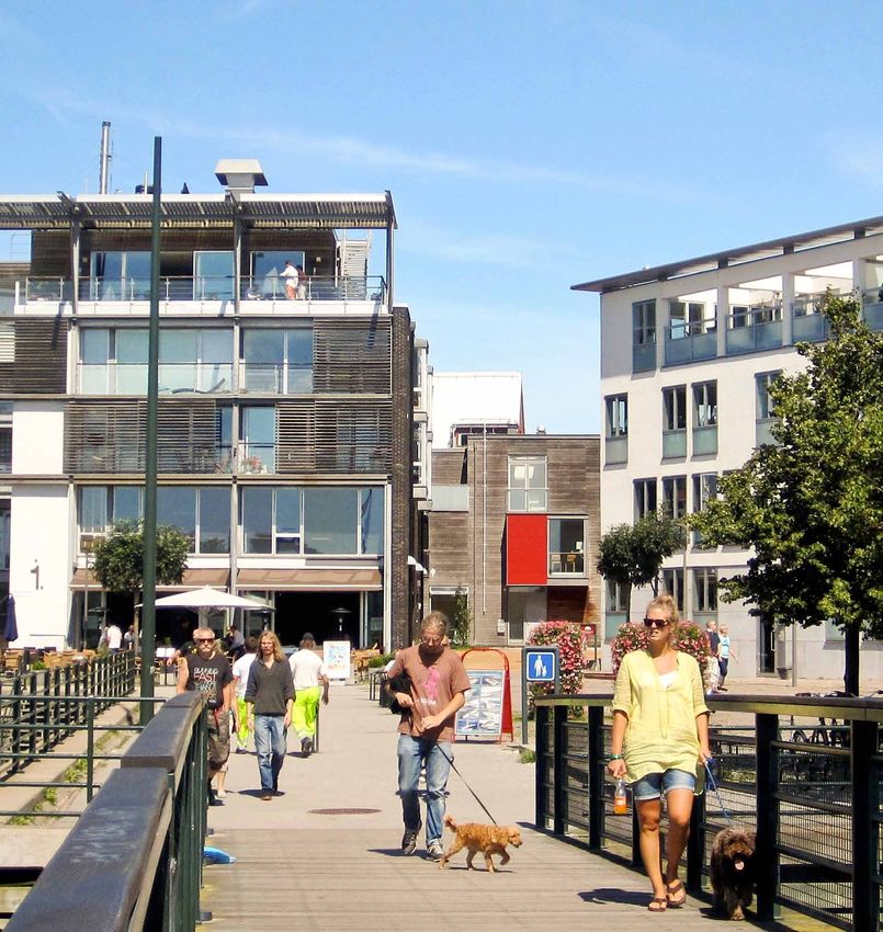
gmv site facts

                              Developer: Greenwich Millennium
                                Village Limited (GMVL)

                              Architect: Ralph Erskine

                              Population: 2,300
                              Developed Area: 20 ha

                              Total Area: 29 ha

                              Current Density: 120 persons/ha

                              Projected Density: 180 persons/ha

                              Current Residential Units: 1,095

                              Planned Residential Units: 2,900

                              Construction Began: 1999

                              Planned Completion: 2014

                              Distance from City Center: 9 km

                              Cars: 350 cars/1,000 residents

                              Parking Spaces/Residence: 0.8
                              Non-motorized Mode Share: 32%

                              Public Transport Mode Share: 49%

case study

Greenwich
Millennium Village
london, united kingdom
Nicole Foletta, ITDP Europe
10 Europe’s Vibrant New Low Car(bon) Communities Greenwich Millennium Village 11
with 20% designated as affordable housing. For the affordable
background section 106 agreements
housing portion of the development, GMVL is working in association
Greenwich Millennium Village (GMV) is an excellent example of sustainable design features and enjoy being part of the special com- with social housing partners Moat Housing. GMVL also agreed to
mixed-use, brownfield redevelopment, well-served by transit, with munity, demonstrating the project’s success not only as a sustain- contribute a specified sum for bus improvements in the area and to
strict parking regulations and a layout that limits through car traffic able development, but as a liveable community as well (Cherry and submit a parking garage management plan. These agreements refer to Section 106 of the British
(Photo 1). While car ownership rates in the development are only Hodkinson 2009). In return, English Partnerships agreed to fund the Millennium Parliament’s Town and Country Planning Act of 1990,
marginally better than in the surrounding area, car use is signifi- To date, 1,095 homes, a primary school, a health center, Busway, a bus only lane running through the development, as well as which regulates the development of land in England
cantly lower. an ecology park and a village square with shops have been com- a state of the art integrated school and health center, which opened and Wales. Section 106 permits local authorities and
GMV is located on the Greenwich Peninsula, a 121-hectare pleted, on 20 hectares (Figure 1). All of the residential units are in 2001 (see Figure 1). English Partnerships also agreed to produce an developers to make agreements over the use of land,
brownfield redevelopment site formerly occupied by the town gas currently occupied. annual travel monitoring study including analysis of mode split and including planning obligations by the developer
works, on the southern banks of the River Thames in southeast The homes completed include a number of live/work units and parking demand of GMV residents in addition to a strategy plan for to contribute towards sustainable communities
London, about 9 kilometers from the London city center. In 1997 a wide range of affordable housing. Developers plan to continue reducing car use. and offset the costs of the external effects of the
English Partnerships1 committed to transforming the Peninsula, expansion of GMV until 2014, including additional housing, retail, Construction of GMV began in 1999 and the first homes were development. Contributions by the developer
one of the largest development sites in London, into a new residen- and a community center, with a total developed area of 29 hectares occupied by 2000. Phases 1 and 2 of the building process were com- may include cash, infrastructure investments or
tial community. The regeneration project is currently in phase one for the entire village (English Partnerships Website). pleted by 2002, producing 1,095 residential units, a village square provision of services. Examples include provision
of a twenty-year build program, which will see 10,000 residential with shops, an artificial lake and an ecology park. of new schools, public space, affordable housing,
units, leisure and retail facilities, as well as educational and health In 2006 a new Section 106 Agreement was signed between the new roads and public transport. Section 106
centers. GMV occupies 29 hectares on the south-eastern side of the Greenwich Peninsula landowners, English Partnerships, and GMVL.
planning process agreements are legally binding and are linked to the
Greenwich Peninsula. This agreement increased the planned development size from 1,400 granting of planning permission. Each agreement
The project was the first “Millennium Community” to be identi- In 1997, English Partnerships launched a competition to design to 2,900 residential units and increased the required share of afford- is different and depends on the unique needs of
fied by English Partnerships and is being developed by Greenwich and build Greenwich Millennium Village, the first community in the able housing from 20% to 35%. The agreement laid out the plans for each community. Some agreements may include
Millennium Village Limited, a joint venture between Countryside Millennium Communities Programme. The competition was won Phases 3 and 4 of the development which will include construction measures aimed at reducing transport-related
Properties and Taylor Wimpey. The Millennium Communities by Greenwich Millennium Village Limited (GMVL), a joint venture of around 1,800 additional new homes, 15,000 square feet of retail emissions. Transport-related measures that have
Programme was launched by English Partnerships alongside the between Countryside Properties and Taylor Wimpey. English spaces, 70,000 square feet of work space, a community center and been included by the Greenwich Council (specifically
Department for Communities and Local Government to create Partnerships and GMVL signed a Section 106 Agreement (see Section a nursery. The planned completion date for Phases 3 and 4 is 2014 for the Woolwich Town Centre Development) include:
seven exemplary sustainable communities nationwide. Each of the 106 Agreements sidebar, p. 11) in which GMVL agreed to build a (English Partnerships Website). provision of carsharing, controls on parking permits,
seven communities is to incorporate high-density housing, green sustainable mixed-use residential development of 1,400 dwellings emission-related parking charges, provision of
spaces, good transport links, and easy access to shops and recre- electric vehicle charging points and use of bio-fuel in
ation facilities, producing quality places where people want to live. key policy and design strategy delivery vehicles (Birch 2010).
In order to ensure that sustainability goals are met, the Millennium
Communities Programme has set standards for energy efficiency, The Millennium Communities Programme has recognized reduced
water consumption, transport, building defects, recycling and health car dependency as a key sustainability issue. This is especially
and safety on site. In line with these goals, the housing at GMV is of apparent in the city of London which has limited room for additional
modern, environmentally-friendly design, and the development aims parking spaces and a high level of traffic congestion. Spurred by
to cut primary energy use by 80%, compared to traditional develop- these concerns, GMV has incorporated several transportation However, during school holidays people are informally allowed to
ments of similar size, using low-energy building techniques and demand management strategies aimed at reducing car dependency park in the school’s parking lot. In addition, residents often rent out
renewable energy technologies. Finally the project aims to reduce car and promoting other, more sustainable forms of transport. their spaces to neighbors during the winter holidays by advertising
dependency by giving priority to cyclists and pedestrians, providing on bulletin boards in the shared spaces. In this way, residents have
access to high quality public transportation, and restricting and pric- Parking taken it upon themselves to manage the existing parking supply as
ing car parking (Photos 2 and 3). As part of its strategy to reduce car dependency, motor vehicle park- efficiently as possible, treating it as a valuable commodity.
London is one of the largest and most congested cities in Europe, ing at GMV is restricted and generally located away from individual
it has also been on the forefront of fighting congestion in part by properties. Parking spaces are only available for 80% of units. Two Cycling and Pedestrian Infrastructure
reducing demand for private car use. While policies like congestion floors of parking garage are located beneath two of the apartment On the flip side, GMV strives to promote cycling and walking. A
charging have been successful in Inner London, car use remains buildings built during Phase 1. In Phase 2, car parking facilities were network of cycle and pedestrian routes runs throughout the village
prevalent in Outer London. Therefore it is important for develop- separated from apartment units and located at the edge of the devel- and beyond, connecting the development to the surrounding areas.
ments such as GMV, located outside the city center, to implement opment. Overall there are 884 parking spaces in the development. For example, a pedestrian walkway leads from GMV to The O2 Arena,
strategies aimed at reducing car dependency. Further, parking spaces are unbundled from apartment units, so a large sports and music venue located in the Millennium Dome on
GMV is marketed as an experiment in sustainable development. residents who choose to have a parking space must pay for it separately the northern side of the Greenwich Peninsula. Within GMV, secure
New residents are given a packet of information on sustainable living from their residence. Residents don’t pay for a specific parking space, bicycle storage facilities are provided for every housing unit and
when they move in. Various studies have shown that residents sup- but rather for a “right to park,” which means they can enter the parking 2–3 bicycle parking spaces are available per unit, including several
port the concept and ethos of the village. Further, they appreciate the garage and must then search for an available space. Prices per space covered, weather-protective bicycle parking facilities (Photo 4).
have gone up since the development was first built, but the current price
Bus Stop Health Center Bus Only Lane is 17,500 gbp per parking space (Marcello Burbante, pers. comm.). Carsharing
1 Walking and
nglish Partnerships was a non-departmental public body funded
E Carsharing School Only residents who have purchased a space are allowed to park in Two carsharing vehicles, provided by Streetcar, are located just to
Cycling Path
through the Department for Communities and Local Government. the garages; visitors are not allowed. Visitors are expected either to the north of GMV (Streetcar Website). These vehicles are located in a
Development
It was responsible for land acquisition and assembly and major Parking Parking
Area Phase I+II park temporarily in the bays on the main roads, which are frequently car bay on John Harrison Way, which boarders GMV. In addition, two
development projects, alone or in joint partnership with private Development
Grocery Store Grocery Store ticketed by the council, or in the public parking lot next to the North Streetcar carsharing vehicles are located in a parking lot off of Tunnel
sector developers. In December 2008 its powers passed to Area Phase III+IV
a successor body, the new Homes and Communities Agency. Greenwich transit station located 0.8 kilometers northwest of GMV. Avenue, about half a kilometer south of GMV. Other than these four
Figure 1: Map of GMV
12 Europe’s Vibrant New Low Car(bon) Communities                                                  Greenwich Millennium Village   13

                                                   1                                   3
                                                   Greenwhich                          Millennium
                                                   Millennium                          Busway
                                                   Village
                                                                                      The Millennium
                                                                                      Busway runs from the
                                                                                      station through GMV,
                                                                                      with two stops located
                                                                                      within the village.

   2
   North
   Greenwich
   Transit Station

 The Underground
 is the most popular
 mode of transport
 for GMV residents.
 The new station
 was built to allow
 for larger volumes
 of passengers and
 provides direct
 connection between
 the Underground
 and 8 bus routes.

                                                                 4
                                                                 Bicycle
                                                                 parking

                                                                Secure bicycle
                                                                storage is provided
                                                                for every housing
                                                                unit, and 2–3 bike
                                                                parking spaces are
                                                                available per unit.
14 Europe’s Vibrant New Low Car(bon) Communities Greenwich Millennium Village 15
vehicles, no other carsharing vehicles from any other companies are pathways separated from motor vehicle traffic throughout the village. Car Ownership Rates Public transit use is high in GMV, particularly for trips to work.
located on Greenwich Peninsula. There seems to be a potential to Furthermore, safety is enhanced through monitoring of transit stops, Figure 2 provides a comparison of car ownership rate per household Indeed, the majority of GMV commuters (79%) travel to work by
locate more carsharing vehicles on this site, particularly inside the cycle routes and pedestrian areas by CCTV. for various segments of London. The rate for GMV falls between that public transit. The breakdown by type of public transport shows that
GMV parking garages themselves. of Inner London, where households are generally less car dependent, 73% of commuters travel to work by London Underground. This is not
Land Use Planning and Design: and that of Outer London, where households are typically more car surprising given GMV’s easy access to the Jubilee Line, connecting the
Urban Design GMV was designed from the beginning as a mixed-use development dependent. The rate for GMV also falls below that for London. These development to central London, and the high cost of driving to central
GMV was designed by masterplanning architect Ralph Erskine to combining residences, retail, commercial and leisure spaces. Phase figures demonstrate that many households in GMV choose to live London due to the city’s congestion charge. Figure 4 shows that a
be a modern urban village, incorporating high density residential 1 of the development consists of blocks of flats 8-10 stories high, car-free, although the car ownership rate is still not quite as low much larger proportion of GMV residents (79%) commute to work
units with green public spaces and providing opportunities for surrounding inner courtyards, with two floors of parking garages as it is in Inner London. by public transit than Inner London residents (59%), Outer London
leisure activities and shopping. Erskine was known for his preference beneath. The highest buildings are located on the northern side of residents (38%), and overall London residents (46%). Further, the
for design with limited through car traffic. He also worked on the the development, along the Thames River, to provide more waterfront Mode Split proportion of GMV residents commuting to work by car is very low.
Bo01 car-free development in Malmö. In line with these principles, views. Phase 2 includes a mix of lower rise flats up to six stories and However, while car ownership in GMV is higher than for Inner Although a small proportion of GMV residents walk or cycle to
Erskine’s vision for GMV was to create a community where the pedes- terraced houses situated around public squares with car parking in a London, car use in GMV appears to be much lower than for other work, a much higher number walk or cycle for other trip purposes
trian has priority over the car. separate block at the side of the development. The residential units areas of London, even Inner London. As seen in Figure 3, only 18% such as traveling to school and shopping (see Figure 5). Nearly one-
include a mix of tenure types. of trips made by GMV residents are by car, which is much lower than third of those who study walk to school, however, almost a quarter
Street Layout and Design: The village square is located near the center of the develop- for Greenwich (44%), Inner London (29%), Outer London (51%) and drive. These results are likely due to the mix of student types; children
Main thoroughfares run along the northwest and southwest borders ment, conveniently located within walking distance of residential London (43%). The GMV data was collected through a survey of are more likely to walk or cycle to school within the village while
of the development. Further, two main thoroughfares run through units so that residents can easily conduct shopping trips and residents conducted to fulfill the requirements for the Section 106 adults taking classes outside the district might be more likely to drive.
GMV. West Parkside bisects the development, while Southern Way errands by bike or on foot. The uses in the village square include Agreement, and included in the Travel Monitoring Study 2005 Report. Further, while about half of residents use their car for their main
splits off from West Parkside midway through the development and a small grocery store, a pharmacy and several cafes. Overall,
runs southward. A two-lane dedicated busway which starts at North the development includes 4,500 square meters of commercial space
Greenwich station passes through the village along West Parkside, along with community facilities such as a school and health center
turning onto Southern Way (Figure 1). The busway is separated from (Countryside Properties Website).
car lanes by a green median. The busway is distinguished by its
brick-red color. On the south side of the village is a road that leads to Figure 2: Car ownership of GMV as compared to surrounding area
the school parking lot. Other than these roads, the development is
quantitative analysis 1.2
car-free and priority is given to cyclists and pedestrians.
The policy and design measures used by GMV work. GMV has 0.95
cars per household
Public Space Design: a much higher residential density than the Greenwich District, 0.8 0.65 0.77
Provision of public spaces was an important component of the design. in which it is located, or London as a whole. And GMV residents
0.50
The village includes an ecology park, a village square and landscaped are far less likely to use a private car (18%) as compared to their
0.4
courtyards. The ecology park, covering 0.2 square kilometers, includes Greenwich neighbors (44%) or Londoners overall (42%). The
two lakes and a thriving wildlife population. In addition, garden squares car ownership rate per resident is also lower for GMV than for
are located through-out the residential areas. The design gives prior- London (Table 1). 0.0
ity to the cyclist and pedestrian, providing pedestrian and cycling GMV Inner London Outer London London
(2005) (2005–06) (2005–06) (2005–06)
Rutherfords, 2005;
Transport for
London, 2010
Table 1: GMV as compared to surrounding area
Figure 3: Mode split for all trips
GMV Greenwich London
100%
Population 2,300 223,000 7,600,000
Area (ha) 20 * 4,700 170,000 car
80% public transit
Population density (persons/ha) 120 47 45
bicycle
Residential units 1,095 100,000 3,000,000
walk
percent of trips
60%
Cars per 1000 residents 350 350 370
Car parking spaces / residential unit 0.80 na na
40%
Mode share for all trips * values shown are
an average of values
Car 18% 44% 42% from 2005-2008.
20%
Public transit 49% 29% 25%
Bicycle 4% 1% 2% 0%
Rutherfords, 2005;
Walking 29% 26% 31% Transport for GMV Greenwich Inner London Outer London London
London, 2009 (2005) (2005–08) (2005–08) * (2005–08) * (2005–08) * Rutherfords, 2005;
Transport for
* current developed area London, 2009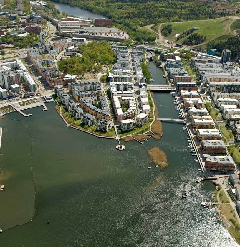
16 Europe’s Vibrant New Low Car(bon) Communities Greenwich Millennium Village 17
weekly food shopping trip, one-third walk or cycle for this trip. Many Not included in Figure 5 are those who have groceries delivered. The trips. Several more live/work units are planned as part of Phases Yet the travel choices of residents within the GMV development
may travel to Sainsbury’s for this trip, the first low energy food store resident survey found that eight percent have groceries delivered to 3 and 4. Overall it was found that 7% of GMV residents work from could still be improved. About half of residents travel by car for their
in Britain, which is located just south of GMV (within one kilometer their residence (Rutherfords 2005). This reduces the number of trips home. This is similar to the proportion for Greenwich (7%) and weekly grocery shopping trip. Increasing the number and diversity
of most residences). The store is 50% more efficient than a standard made by residents, but the effect on carbon footprint of these trips slightly lower than for Inner London (9%), Outer London (9%), of stores located at GMV could encourage more walking and cycling
supermarket, incorporating use of natural light, high levels of insula- depends on delivery vehicle fuel and scheduling efficiency. and London (9%) (Rutherfords 2005). trips within the development as opposed to driving. Eight percent
tion, passive ventilation and under-floor heating systems (GMV In addition, more than half of residents walk or cycle for other shop- The results of this analysis show that the policy and design of residents already have groceries delivered; stores could further
Website). However, while the supermarket has a focus on energy ping trips. Providing a wide variety of shops in the village makes it more measures applied in GMV appear to have had a strong influence on promote this service to encourage shoppers to leave their cars at
sustainability, it seems to have overlooked transport sustainability convenient for residents to walk for these trips. The survey of residents reducing car trips made by residents, however potential remains to home. It is important to ensure that these deliveries are made using
as it caters to the car; the store is located next to an extensive park- was taken in 2005, and the number of shops in the village square has increase cycling trips, particularly within the development. sustainable transportation practices.
ing lot with more than 300 free to use spaces. The ease of accessible been expanded since that time, so it is likely that a more current survey GMV also provides live/work units. However, at the time of the
parking might encourage GMV residents to drive to the store rather would show a higher proportion of walking and cycling trips. survey in 2005, the presence of these units did not seem to increase
than cycle or walk. The store is also accessible by bus; however, Many live/work units are provided at GMV to encourage resi- the proportion of residents working from home above that of the
lessons learned
Figure 5 shows that few residents travel by bus to the grocery store. dents to work from home, thus reducing the number of commute surrounding area. Promotion of these units and addition of units in
While GMV residents drive less than their neighbors due to strong Phases 3 and 4 may encourage more residents to work from home.
policy and design measures, overall car ownership remains higher Home offices have the obvious benefit of reducing commute trips.
than some of the other communities we reviewed. This is due in part However, some studies have shown an increase in other trips due to
to the location of GMV, far from central London, which demonstrates the increased flexibility of the work schedule. This is another reason
the importance of locating new development as close as possible to why it is essential to provide amenities within walking distance of
Figure 4: Mode of travel to work existing development. residences in order to encourage residents to walk and cycle for their
The good news is, GMV’s good public transit access, combined daily needs rather than traveling outside the development by car to
100% with the existence of London’s congestion fee, have resulted in an access goods and services.
impressive commute mode share of 79% by public transit.
car
80% bus
train
percent of residents
60% underground
bicycle
walk
40%
20%
0%
GMV Inner London Outer London London
(2005) (2005) (2005) (2005) Rutherfords, 2005;
Transport for
London Website
sources
Figure 5: GMV resident mode of travel for various trip types, 2005
100%
car Birch, Carolyn (2010). Using Section 106 Communities — A New Approach to Planning Congestion Charging: Impacts Monitoring —
80% bus Agreements to Improve Air Quality, Communities Obligations, Eland House, London. Sixth Annual Report, London.
and Local Government, London. English Partnerships (2007). Millennium Com- Transport for London (2009). Travel in London —
train
Cherry, Alan and Hodkinson, Richard (2009). munities Programme, London. http://www. Key Trends and Developments Report
percent of residents
60% underground Millennium Homes Revisited, Ingenia, Issue 41, urbandesigncompendium.co.uk/public/docu- Number 1, London.
bicycle December 2009. http://www.ingenia.org.uk/ ments/Mill%20Comms%20May%202007.pdf Transport for London (2010). Travel in London:
ingenia/issues/issue41/Cherry_Hodkinson.pdf English Partnerships website, http://www. Report 2, London.
walk
40% Communication with Kim Smith, Transportation englishpartnerships.co.uk/gmv.htm (accessed Transport for London website, http://www.tfl.gov.
Planning and Strategy Manager, Greenwich June 28, 2010). uk/ (accessed September 21, 2010).
Council, May 4, 2010. GMV website, http://www.gmv.gb.com/transport.
20% Communication with Marcello Burbante, htm (accessed September 21, 2010). Image credits
Greenwich Millennium Village Ltd. (GMVL), Rutherfords — Highway & Transport Planning Figure 1: http://maps.google.de/maps/ms?hl=en
September 3, 2010. (2005). Greenwich Millennium Village: Travel &ie=UTF8&vps=3&jsv=298d&oe=UTF8&msa=
0% Coutryside Properties website, http://www. Monitoring Study, 2005 Report, Cambridge. 0&msid=116478322990710211544.000491ed99c
work education main weekly other shopping countryside-properties-corporate.com (accessed Streetcar website, http://www.streetcar. ace2d3ecac
grocery shopping
September 21, 2010). co.uk/location.aspx?location=633 (accessed Photo 1: Andrew Sparkes, www.pinholedesign.co.uk
Rutherfords, 2005
Department for Communities and Local Govern- September 21, 2010). Photo 2: Nicole Foletta, ITDP Europe
ment (2004). Contributing to Sustainable Transport for London (2008). Central London Photos 3, 4: Frederique Siegel, ITDP Europe
gwl terrein site facts

Developer: Ecoplan Foundation

Architect: Kees Christiaanse

Population: 1,400

Area: 6 ha

Density: 230 persons/ha

Residential Units: 600

Construction Began: 1995

Construction Completed: 1998

Distance from City Center: 3 km

Cars: 190 cars/1,000 residents

Parking Spaces/Residence: 0.20

Non-motorized Mode Share: 80%

Public Transport Mode Share: 14%

Households with Carsharing: 26%

                                   case study

                                   GWL Terrein
                                   amsterdam, the netherlands

                                   Nicole Foletta, ITDP Europe
20 Europe’s Vibrant New Low Car(bon) Communities GWL Terrein 21
background key policy and design measures
GWL Terrein is a car-free brownfield redevelopment with limited park- and energy consumption. In addition, it was decided that half of the From the start, GWL Terrein had a focus on reduced car usage and with neighbors and also provide residents with a sense of ownership
ing, carsharing provision and good transit access. Non-motorized dwellings would be reserved as renter-occupied, social housing. The sustainable living. These sentiments came from local residents of for the public spaces.
mode share in the development is much higher than the surrounding other half would be sold, two-thirds of which would be grant-aided the Westerpark District and were supported by the local government. The area does not have any dedicated cycle lanes, but rather
area and car use is much lower. owner-occupied dwellings. Furthermore, local residents would have Several policy and design strategies have been incorporated into the provides wide, mixed use pathways (shared by pedestrians and
GWL Terrein is located in the famously cycling-friendly city of priority in applying for dwellings. site to help actualize this ideal. These are described below. cyclists). One perspective is that this mix of uses can actually
Amsterdam. The project is in the Amsterdam West District, three kilo- The Westerpark Urban District commissioned two architecture improve safety because both cyclists and pedestrians are more
meters from the city center at the terminus of a tram line and the very firms to create a conceptual plan for the development based on the Urban Design aware of their surroundings, looking out for fellow travelers rather
edge of the late 19th century city extensions. It makes use of a six Urban Planning Schedule of Requirements. In August 1993 the plan As mentioned, the entire six hectare site of GWL Terrein is car-free. than assuming that paths will be segregated.
hectare site formerly used by the municipal water utility, Gemeente made by architect Kees Christiaanse and landscape designer Adriaan The development consists of 17 buildings along with the renovated
Waterleidingen (GWL), from which it gets its name (Photos 1 and 2). Geuze was chosen by a panel consisting of several inhabitants, pump engine building, which is now home to a café. The buildings Land Use Planning and Design
Local residents were involved in the design and development of the representatives of the Westerpark Urban District and the project are arranged to form a high density perimeter, while the inner areas The site contains a few renovated historical buildings and the GWL
project. They wanted to push forward with a new approach to devel- developer. This panel, along with the architect, then collaborated to remain open, including plenty of green public spaces, wide pathways water tower, which acts as a landmark of the district, surrounded
opment focused on car-free living, reuse of resources, conservation create an Urban Plan for the development, which was completed in and safe areas for children to play (Photo 4). by blocks of high density housing, designed by five different design
of energy and water, and community cohesion. November 1993. The Environmental Advisory Bureau (BOOM) was teams, but all with a similar color scheme to bring cohesion to the
The inner area of the development is car-free and only emergency also involved in the process to ensure that the environmental aspects Street Layout and Design development. One elongated, 186-meter long, high-rise apartment
vehicles are allowed on site. The original residents were asked to of the Urban Planning Schedule of Requirements were upheld. Since cars are not allowed on site, no streets pass through the building with nine stories runs along Waterpootweg Street, the
sign a non-obligatory declaration of support for the car-free nature Given the strict environmental requirements proposed, private development. Furthermore, signs are posted at various entrance eastern border of the development (see Figure 1). Another elongated
of the site. None of the 600 residential units include parking spaces, investors were not interested in developing the site. Ultimately five points, stating that no motorized vehicles are allowed on the apartment complex runs along the north and northeastern borders
however, several on-street parking spaces are located along the edge housing associations set up the Ecoplan Foundation as a joint ven- site (Photo 5). In order to enforce this, the development is raised of the site. This building structure helps to create enclosed areas
of the development and a limited number of parking permits are ture to coordinate and finance the development. Future inhabitants from street level so that cars do not have access to the inner area within the development without applying gates or barriers between
available for residents. continued to be involved in the design process. In 1994, five design (Photo 6). However, ramped access points are located at certain GWL Terrein and other neighborhoods. To the east, GWL Terrein is
GWL Terrein’s environmental and social goals make it a unique teams were created, each with an architect and several inhabitants, entrances to the development, and sometimes motorized two- open and pathways connect the development to the 19th century
place to live. The car-free inner area creates a cleaner, safer place to design various sections of the development. Construction took wheelers illegally enter the development. Police officers patrol the neighborhoods. Overall 17 apartment buildings are located on-site.
for neighbors to interact and children to play. The focus on energy place in three phases, starting in 1995 and ending in 1998 (Photos area to limit these infractions. As many dwellings as possible have an entrance at street level and
efficient building design and promotion of sustainable transporta- 2 and 3) (GWL Terrein website). Van Hallstraat (Photo 7), an arterial street at the eastern border access to either a private ground floor garden, a rooftop garden or
tion helps reduce the carbon footprint of residents. Furthermore, the of GWL Terrein, was traffic-calmed in 1999 with on-street parking an open terrace. Incorporated into these residential buildings are
work of the residential umbrella organization encourages sustain- removed, speed reduced, sidewalks widened and the tram terminus ground floor commercial uses, live/work units, housing for persons
able living and community involvement. It is no surprise that the rebuilt and extended (Scheurer 2001). Van Hallstraat also has a with mental disabilities, senior housing and wheelchair accessible
development consistently receives high satisfaction ratings from brick-colored cycle lane. Near the tram terminus, this cycle lane is housing (Photo 8).
residents, which is further underscored by the fact that 62% of bordered by the tram platform and two tram lanes. Beyond the tram Most of the apartments have 3-4 rooms with an average of 3.44
residents have lived in the development for more than eight years lanes are two lanes of traffic, followed by car parking and another rooms per home. This is higher than the average for the Westerpark
(GWL Terrein Website). Once residents move here they don’t seem to cycle lane at the furthest side of the street. For the rest of Van District of 2.64 rooms per home. The average home value is also
want to leave. What began as an idealistic experiment in combining Hallstraat the cycle lane bordering GWL Terrein is protected by a tree- higher in GWL Terrein. In 2005 the average home value in GWL Terrein
high density housing with green principles appears to have produced lined median. Beyond this median are two car lanes. At the far side of was 256,000€ versus 172,000 € for the Westerpark District. The larger
a neighborhood its original proponents can be proud of, even ten the street is a lane for car parking and another cycle path. In this way, size of residential units and higher quality housing are attractive
years later. cycle lanes are protected from moving traffic either by a row of trees, features for families. Furthermore, 55% of residential units are
a tram platform, or a strip of parked cars. owner-occupied and 45% are renter-occupied. Of the rented units,
60% are social housing.
Public Space Design Several other uses are also located on the site such as the
planning process
A variety of public spaces are available between the buildings, Westerpark Community Center. The water company’s pumping
GWL Terrein occupies the former site of the Municipal Water Company. including public green spaces, children’s play areas, shared gardens station was restored and the old engine room is now home to Café
When the water company decided to move, residents of what and mixed use pathways. This is important, since in such a high Amsterdam, a popular restaurant which attracts many visitors to the
was then the Westerpark District (now part of the Amsterdam West density development, it is impossible to provide each residential district (Photo 9). The remaining space in the historic pumping sta-
District) lobbied for the location to become a residential area, unit with a private yard. Beyond being a more efficient use of space, tion was converted to offices and a gym. Overall, 50 businesses are
while companies operating nearby wanted the location to be zoned these shared spaces provide residents with more chances to interact, located at GWL Terrein (many of them home businesses) employing
for industrial purposes. The residents won out and in 1989 the building their sense of community. 216 people (GWL Terrein Website). The mix of uses provides residents
Amsterdam city council decided to zone the area for housing. Local An artificial canal effectively divides the development into two with shopping, entertainment and employment options within their
residents remained actively involved in the decision process and parts. To the north is an urban square surrounded by a nine-story own neighborhood. In addition, several grocery stores, shops, phar-
appealed for a car-free eco-district. This idea was also supported by residential building with ground floor retail. To the south the site is macies and cafes are located in the surrounding neighborhoods so
politicians and the local community center. more garden-oriented with open green spaces and children’s play that residents do not have to go far to run their daily errands, which
In 1993 the basic principles for the site were described in an areas. The children’s play areas are located away from the street can easily be done by bicycle or walking.
Urban Planning Schedule of Requirements (SPvE). The site was and have been praised by many families as being safe places where
to be car-free and aimed to discourage car ownership and use by their children can play near home. In addition, several shared garden Public Transportation
ensuring good public transport, a safe environment for pedestrians allotments are provided; which are surrounded by a protective wall GWL Terrein is well served by public transportation. Tram line 10 was
and selecting inhabitants who agreed with the ecological principles of shrubbery. Within these spaces, residents can rent a garden allot- extended and terminates just outside the development at the Van
of the project. Environmental goals also included reduction in water ment. The gardens give residents another opportunity to interact Halstraat station (Photo 10). The tram lanes are segregated from car
Figure 1: GWL Terrein site map22 Europe’s Vibrant New Low Car(bon) Communities GWL Terrein 23
1 3
GWL Terrein GWL Terrein
before development
redevelopment
4
Children
playing near
GWL Terrein’s
2 main landmark,
GWL Terrein the watertower
after
redevelopment
5
No motorized
vehicles are
allowed in GWL
Terrein24 Europe’s Vibrant New Low Car(bon) Communities GWL Terrein 25
6 8
Bollards and raised Many ground floor
curbs prevent units are reserved
motor vehicles from for seniors and the
entering. disabled and have
ramped access for
wheelchairs.
9
Café
Amsterdam
7
Family
cycling on
Van Hallstraat
Half of all trips made
in GWL Terrein are
by bike.
10
Tram 10 at
Van Hallstraat
Station26 Europe’s Vibrant New Low Car(bon) Communities GWL Terrein 27
traffic lanes which helps to increase tram speeds. The tram runs at therefore first-come-first-served. The spaces are metered, costing Development Management and Governance
10-minute intervals. In addition, two bus lines serve the development. three Euros per hour (versus five Euros per hour for on-street parking The umbrella organization Koepelvereniging was created in 1996 to also provides advice related to sustainability and car-free living.
Bus line 21 provides service to Central Station every 10 minutes. Bus in central Amsterdam). Residential parking permits for these spaces promote the original intentions of the development and to encour- Therefore, while new residents are no longer asked to state that they
line 60 provides service to Sloterdijk Station every 10 minutes. cost 16 Euros per month, which is much cheaper than hourly parking, age community cohesion. The organization is funded through agree with the ideals of the project, they are still made aware of the
A variety of transit ticket types are available for travel within the however these permits are extremely limited. Only 110 parking per- small fees from residents and the housing associations. Today project’s original intentions.
city of Amsterdam. Public transportation users can buy a one-hour mits, representing 18% of households, are available for GWL Terrein Koepelvereniging is the one body that unifies the entire develop-
ticket, or daily tickets, good for unlimited travel within Amsterdam residents and those on the waitlist may wait up to seven years for ment. The organization has a website and a newsletter for residents
by tram, bus or metro. Seasonal passes are also available including a permit. Residents of GWL Terrein do not qualify for residential park- and holds about six meetings per year to discuss community issues
quantitative analysis
weekly, monthly and annual passes. The fares for these passes are ing permits in the nearby neighborhoods, but some residents have such as safety, maintenance and community events. The organiza-
zone-based and discounts are available for youth and seniors. All been known to “borrow” parking permits in order to park their cars tion also employs a concierge, who is available on-site to answer GWL Terrein is located in one of the world’s leading cycling cities.
ticket types and passes can be loaded onto the recently implemented in the surrounding areas (GWL Terrein Website). A 480-space parking questions from residents, performs minor repairs and enforces the The City of Amsterdam has implemented many policies to encourage
OV-chipkaart, a contactless smartcard that must be swiped upon lot is located nearby which charges 3 Euros per hour for parking up car-free restriction (including keeping delivery vehicles from entering cycling and walking and to reduce car use such as improved bicycle
entering and exiting the public transport vehicle or station. In addi- to a maximum of 30 Euros per day. A variety of parking subscrip- the development). Residents are very involved in the organization infrastructure, extensive bicycle parking facilities, robust police
tion, smartcard users may choose to pay based on the distance they tions are also available which range from 98 to 295 Euros per month and help to plan community events, such as an annual soccer tourna- enforcement to prevent bicycle theft, increased bicycle use education
travel. The OV-chipkaart can be used on all public transportation (QPark Website). ment held each June, followed by a community dinner (GWL Terrein to increase bicycle safety, reduced speed limits to improve safety and
throughout the Netherlands, although fares may vary depending on Website). These efforts help to give residents a sense of community increased parking prices to reduce car use (Daniel van Motman, pers.
the region. (GVB Website) Carsharing and enhanced focus on the environmental goals of the development. comm.). However, efforts at GWL Terrein go even further. GWL Terrein
Five carsharing vehicles are located in the parking spaces on the residents have a 50% bicycle mode share, compared with the already
Parking boarder of the development, belonging to two carsharing organiza- Car-free Declaration high 30% in the rest of the city, further reducing the carbon footprint
Parking for the development is extremely limited. None of the tions: Greenwheels and Diks. Since one of the main goals of the Initial proponents of the development had hoped to actually ban of residents. A comparison of statistics for GWL Terrein, Amsterdam
residential units have parking spaces on-site. 129 on-street parking development is to reduce car ownership, provision of carsharing is car ownership among residents, but this was not allowed. As an West and the city of Amsterdam can be seen in Table 2.
spaces are located on the west side of the district, five of which are important to give residents access to a car without having to own one. alternative, Ecoplan asked the initial residents of GWL Terrein to sign
reserved for carsharing vehicles and two for persons with dis- The vehicles are very popular among residents. Over a quarter of house- a non-obligatory declaration of support for the car-free nature of the Density
abilities. The remaining 122 spaces, equating to 0.2 spaces per holds have a carsharing membership (ITDP Europe 2010). Information site. This declaration did not require residents to live car-free, but GWL Terrein is about three times as dense as Amsterdam West,
residential unit, are part of the city’s public parking supply and are about the two carsharing companies can be seen in Table 1. informed them of the intention of the development. The declaration the district in which it is located, and more than five times as dense
reminded residents that GWL Terrein is different from other neighbor- as the city of Amsterdam. It is even more dense than what is required
hoods. Parking in the area is difficult for a reason and sustainable for new growth, or Vinex, locations in the Netherlands (see Vinex
Table 1: Information about carsharing companies in GWL Terrein
forms of transportation are encouraged. Furthermore, the declara- Locations sidebar, p. 50). Vinex locations are required to have at
Diks Greenwheels tion attempted to provide residents with an enhanced feeling of com- least 30 homes per hectare, while GWL Terrein has 100 homes per
munity and the idea that they were involved in a unique experiment hectare. Higher densities enable more efficient use of resources,
Deposit 50 € 225 €
in sustainable living. However, new residents no longer go through which can contribute to reductions in carbon footprint.
Monthly subscription fee 25 € Ranges from 5–25 €
Ecoplan. New renters are selected either by one of the five housing
Fee per km 0.12 € 0.10 € associations, which typically do not require a car-free declaration to Parking
Hourly fee 2.75 € 2.50 € be signed, or by current owners, who may freely sell their property Parking at GWL Terrein is extremely limited with only 0.20 spaces per
to anyone they choose. For this reason, the umbrella organization residential unit, compared to the already low 0,72 spaces in the rest
Discounts available None Discount with Dutch Railway card (NS card)
Koepelvereniging has developed a document for new residents, of the city. Reducing the availability of parking spaces contributes to
Company membership option No Yes explaining the goals and concepts of the project. The organization reduced car ownership rate.
Number of cars available 3 2 http://www.diks.net/
at GWL Terrein Location autodate-tekst.html,
http://www.greenwheels.nl
Table 2: GWL Terrein compared to surrounding areas
Figure 2: Mode of travel for residents as compared to surrounding area
GWL Terrein Amsterdam West Amsterdam
Population 1,400 77,510 757,000 100%
Area (ha) 6 990 22,000 car
80% public transport
Population density (persons/ha) 230 78 34
bicycle
Number of residential units 600 na 390,000
walking
percent of trips
60%
Cars per 1,000 residents 190 310 370
walk /cycle
Bikes per 1,000 residents 1,300 na 730
40%
Car parking spaces / residential unit 0.20 na 0.72
Mode share for all trips
20%
Car 6% 20% 28%
Public transit 14% 18% 18% 0%
GWL Terrein GWL Terrein Amsterdam Amsterdam Amsterdam Amsterdam
Bicycle 50% 32% 29% (2001) (2010) West West (2000) (2008)
City of Amsterdam,
(2000) (2008)
City of Amsterdam; ITDP Europe, 2010;
Walking 30% 30% 25% Scheurer, 2001
ITDP Europe, 2010You can also read