BENTLEY - SUBMISSION DRAFT JUNE 2021 - Neighbourhood Plan 2018 2037 - Mid Suffolk District Council
←
→
Page content transcription
If your browser does not render page correctly, please read the page content below
BENTLEY
Neighbourhood Plan 2018 - 2037

SUBMISSION DRAFT
JUNE 2021

BENTLEY PARISH COUNCIL
Prepared by the Bentley Neighbourhood Plan Working Group on behalf of Bentley Parish Council
    and supported by Places4People Planning Consultancy

2
CONTENTS

   1.    INTRODUCTION                                                                    5
   2.    VISION STATEMENT AND PLAN OBJECTIVES                                            7
   3.    BENTLEY IN CONTEXT                                                              9
   4.    PLANNING POLICY CONTEXT                                                        13
   5     SPATIAL STRATEGY                                                               15
         POLICY BEN 1 - SPATIAL STRATEGY                                                16
   6.    HOUSING					                                                                   17
         POLICY BEN 2 - HOUSING DEVELOPMENT                                             19
         POLICY BEN 3 - LAND AT OAKLEIGH, CAPEL ROAD                                    20
         POLICY BEN 4 - LAND AT THE FRUIT FARM, CAPEL ROAD                              23
         POLICY BEN 5 - AFFORDABLE HOUSING ON RURAL EXCEPTION SITES                     25
         POLICY BEN 6 - HOUSING MIX                                                     26
   7.    THE BUILT ENVIRONMENT                                                          29
         POLICY BEN 7 - DEVELOPMENT DESIGN                                              31
         POLICY BEN 8 - FLOODING AND SUSTAINABLE DRAINAGE                               32
         POLICY BEN 9 - PARKING STANDARDS                                               35
   8.    NATURAL ENVIRONMENT                                                            37
         POLICY BEN 10 - DEVELOPMENT AFFECTING THE AREA OF OUTSTANDING NATURAL BEAUTY   38
         POLICY BEN 11 - PROTECTING BENTLEY’S LANDSCAPE CHARACTER                       41
         POLICY BEN 12 - PROTECTING HABITATS AND WILDLIFE CORRIDORS                     43
         POLICY BEN 13 - RECREATIONAL DISTURBANCE AVOIDANCE AND MITIGATION              43
         POLICY BEN 14 - DARK SKIES AND STREET LIGHTING                                 44
   9.    HISTORIC ENVIRONMENT                                                           45
         POLICY BEN 15 - HERITAGE ASSETS                                                46
         POLICY BEN 16 - BUILDINGS OF LOCAL SIGNIFICANCE                                46
   10.   DEVELOPMENT OF INFRASTRUCTURE AND SERVICES                                     47
         POLICY BEN 17 - SUSTAINABLE TRANSPORT INFRASTRUCTURE AND SERVICES              47
   11.   COMMUNITY FACILITIES                                                           51
         POLICY BEN 18 - PROTECTING EXISTING SERVICES AND FACILITIES                    51
         POLICY BEN 19 - SPORT AND RECREATION FACILITIES                                52
         POLICY BEN 20 - LOCAL GREEN SPACES                                             54
         POLICY BEN 21 - COMMUNICATIONS TECHNOLOGY                                      54
         POLICY BEN 22 - BROADBAND                                                      54
         POLICY BEN 23 - INFRASTRUCTURE DELIVERY                                        55
   POLICIES MAP 					                                                                   56
   APPENDICES							                                                                    58
   APPENDIX A - HOUSING PLANNING PERMISSIONS                                            58
   APPENDIX B - DEVELOPMENT DESIGN CHECKLIST                                            60
   APPENDIX C - PROTECTED HABITATS AND SPECIES                                          63
   APPENDIX D - BUILDINGS OF LOCAL SIGNIFICANCE                                         64
   APPENDIX E - PARISH INFRASTRUCTURE INVESTMENT PLAN                                   68
   GLOSSARY							                                                                      69

                               BENTLEY NEIGHBOURHOOD PLAN                                    3
4 BENTLEY NEIGHBOURHOOD PLAN
1
      INTRODUCTION

FRAMEWORK                                                     1.6   The Neighbourhood Plan has been prepared
                                                                    in accordance with the requirements of the
1.1   The Localism Act 2011 introduced new rights and               Government’s Neighbourhood Planning Regulations
      powers to allow local communities to shape new                and, in particular, has involved local community
      development in their community by preparing                   engagement to gather evidence to support the
      a Neighbourhood Development Plan, which                       content of the Plan.
      can establish general planning policies for the
      development and use of land in the neighbourhood.       1.7   At the outset of preparing the Neighbourhood Plan,
      This document is a Neighbourhood Development                  an initial residents’ meeting was held on 12th June
      Plan (the Neighbourhood Plan) and has been                    2018 in the Village Hall to gauge support from the
      prepared by Bentley Parish Council, which is the              village for the Plan, and to share the Neighbourhood
      “qualifying body” as defined in the Localism Act              Plan process.109 residents attended, and about
      2011.                                                         20 volunteered to sit on the Neighbourhood Plan
                                                                    committee. The Parish Council voted to go ahead
1.2   A Neighbourhood Development Plan is a                         with the Plan at its meeting of 12th July 2018.
      community-led planning framework for guiding the
      future development, regeneration, and conservation      1.8   On 16th July 2018, in accordance with the
      of an area. It is about the use and development of            Neighbourhood Planning Regulations, Babergh
      land and contains a vision statement, aims, planning          District Council formally designated the whole
      policies, and proposals for improving the area or             parish as a Neighbourhood Plan Area, as illustrated
      providing new facilities, or for allocation of sites          in Map 1. Details of the application, publication and
      suitable for development.                                     designation can be viewed on the District Council’s
                                                                    website under Neighbourhood Planning in Bentley.
1.3   This Draft Neighbourhood Plan has been prepared               There are no other designated neighbourhood
      to conform with the strategic planning policies               plan areas within this boundary and the Parish
      of the emerging Babergh and Mid Suffolk Joint                 Council is the “qualifying body” responsible for the
      Local Plan [hereafter, the JLP] whilst reflecting the         preparation of the neighbourhood plan for this area.
      aspirations of the local community. Importantly, the
      Plan has focused on housing matters in the light        1.9   The primary driver for the policies in the Plan
      of the planning policy and housing land situation             is the responses to the Village and Children’s
      in Babergh at the time of writing. This is explained          Questionnaires, both of which had an excellent
      further in the Policy Context section of the Plan.            response rate representing 38% of the population.
                                                                    The village continues to be involved, with regular
1.4   The Neighbourhood Plan contains planning policies             updates in the Parish magazine and to the Parish
      that will, when the Plan is completed, form part of           Council, with Open Evenings, and via stalls at the
      the statutory development plan which will be used             Village Fun Days. In addition, the Neighbourhood
      for determining planning applications in the parish.          Plan team commissioned a Design Guide, a Housing
1.5   The Neighbourhood Plan Regulations require a                  Needs Assessment, a Master Plan for a proposed
      Neighbourhood Plan to:                                        site, and a Landscape Assessment, all of which have
         • Be appropriate, having regard to National                informed policies.
      		 Planning Policy.
         • Contribute to achieving sustainable
      		development.
         • Be in general conformity with strategic
      		 policies in the development plan for the local
      		area;
         • Be compatible with EU obligations and
      		 Human Rights requirements.

                                               BENTLEY NEIGHBOURHOOD PLAN                                              5
Bentley Neighbourhood Plan Area

      © Contains Ordnance Survey Data: Crown copyright and database right 2020 All rights reserved (100046170) 2020

      Map 1

6                                             BENTLEY NEIGHBOURHOOD PLAN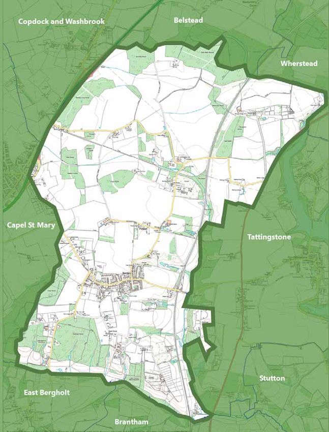
2.         Vision Statement
 		        and Plan Objectives

      Arising out of the Village Questionnaire, informed by the various studies commissioned by the
      Neighbourhood Plan team (Landscape Appraisal, Design Guide, and Housing Needs Assessment),
      and in consultation with the villagers, the following Vision has been established.

                                         Vision Statement
             Our vision is to conserve the sense of community within Bentley,
              to ensure that we have the robustness to meet the challenges
            ahead - to enhance our rural nature and agricultural surroundings,
               for a safe and vibrant place to live for generations to come

      To deliver our Vision. The Plan addresses six themes, namely

          • Housing
          • The Built Environment
          • The Natural Environment
          • Historic Environment
          • Development of Infrastructure and Services
          • Community Facilities
      •

           Housing Objectives

                  1 To encourage the development of appropriate housing for the
                    stated needs of the village, in terms of size and style and across the
                    age demographic.

           Built Environment Objectives

                  2 To maintain and enhance a strong rural identity and sense of place
                    for the parish, through environmentally sustainable and sensitive
                    small-scale development.
                  3 To ensure new development is designed to reflect local character
                    and incorporates measures that reduces environmental impact.

                                        BENTLEY NEIGHBOURHOOD PLAN                                    7
Natural Environment Objectives

        4 To retain, encourage, and enhance local natural habitats, to
          conserve Priority Species and increase biodiversity, and to maintain
          the strong sense of rural place within the parish. To enhance habitat
          connectivity (wildlife corridors) to allow species to move into and
          across these habitats.

        5 To have regard for our duty of care to the Suffolk Coasts and Heaths
          Area of Outstanding Natural Beauty within the parish and its
          setting, and to protect its special qualities, particularly tranquillity
          and large skies in a rural landscape.

    Historic Environment Objectives

        6 To conserve and enhance our heritage assets

    Development of Infrastructure and Services Objectives
        7 To encourage safe and sustainable options for travel in and around
          the village for pedestrians, cyclists, and horse riders.

        8 To support the creation of infrastructure, such as fast broadband
          and transport links that allow commuting via public transport, to
          encourage a broad age spectrum within the village.

    Community Facilities Objectives

        9 To conserve and enhance the sense of robust, resilient, vibrant
          community within the village, maintaining the village as a safe and
          desirable place to live for all its residents.

8                            BENTLEY NEIGHBOURHOOD PLAN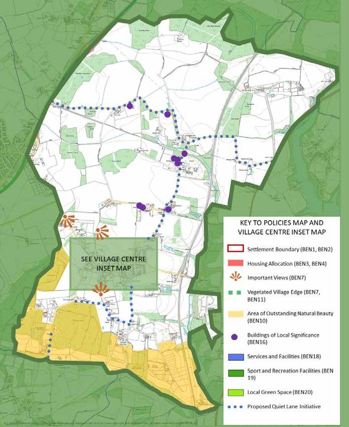
3. Bentley in Context

HISTORY AND CONTEXT
3.1   The Heritage Suffolk report on the parish describes a setting that has been primarily agricultural in nature since
      records began.
3.2   In 1086, the Domesday Book described Bentley (population 31) as having:
       • “12 acres meadow, woodland for 42 pigs, 8 cattle, 7 pigs, 42 sheep, 1 mill at Dodnash”

      Map 2
      Mediaeval woodlands in Suffolk, from An Historical Atlas of Suffolk, with kind permission of Edward Martin

                                             BENTLEY NEIGHBOURHOOD PLAN                                                    9
3.3   The Domesday Book also mentions St Mary’s church,              • River valleys which still possess traditional grazing
      with its 30 acres of free land; the early history of             meadows with their hedgerows, dykes, and
      the parish is interesting, with Mesolithic, Neolithic,           associated flora and fauna;
      Bronze Age, Iron Age, and Roman finds reported                 • Historic parklands and gardens;
      within the parish, and a Roman road forming part               • Other areas of countryside where undulating
      of its northern boundary. Around 1230 Dodnash                    topography and natural vegetation, particularly
      Priory (founded in 1188 in East Bergholt) moved to               broadleaved woodland, combine to produce an
      Bentley, and its Augustinian monks served the parish             area of special landscape quality and character.
      until it was dissolved shortly before the Reformation.
                                                               3.10 This attractive landscape adds to the amenity value
3.4   In 1674, the number of inhabited houses was 39,               of the village. Distinctive views are to be found
      and it did not change significantly until the coming          looking into and out of the village settlement.
      of the railway (Bentley had its own station until the         Footpaths provide a link between the whole, with a
      Beeching cuts). In 1851, the number of inhabited              well-used circular route and spokes providing many
      houses had rocketed to 94. In 1951, following the             walks around and into the village. It brings the
      construction of a council housing estate, it had              countryside to our doorstep.
      grown to 157; and in 1981, the number was 309.
3.5   In terms of public houses, the village boasted three     Hedgerows
      in 1912; the village has bought the last remaining
                                                               3.11 Ancient hedgerows support the great hedgerow
      one, the Case is Altered, and runs it as a community
                                                                    diversity of plants and animals. Species-rich
      pub, with a community-owned shop in its grounds.
                                                                    hedgerows, defined as those averaging five or
                                                                    more native woody species per 30 metre length,
                                                                    are generally recognised to have been in existence
Landscape and village                                               before the Enclosure Acts of 1720-1840. A notable
3.6   Bentley is set within a deeply rural landscape. The           finding of the Suffolk Hedgerow Survey 1998-2012
      Suffolk Landscape Character Assessment (http://               is that, in Suffolk, 20,179 landscape hedges (52%
      www.suffolklandscape.org.uk/) characterises most              of those surveyed) were shown to have eight or
      of the parish as “ancient estate farmlands”, whose            more woody species, and 11,940 (31.2%) others
      key characteristics are:                                      contained five to seven species: a sum of 32,119
      • A plateau of easily farmed rich loams with                  hedges (83.9%) that are probably between three
          a planned estate layout and blocks of ancient             and possibly twenty centuries in age.
          woodland, with
                                                               3.12 In Bentley, a team of 28 volunteers undertook
      • Flat central spine of land, with sloping sides
                                                                    the task of surveying all the hedgerows (419) in
          dissected by river valleys
                                                                    the parish over the period 2001-2012. The data
      • Deep loamy soil that originated as wind-blow
                                                                    revealed that Bentley parish Ancient Estate Farmland
          sediments from glacial sources
                                                                    comprised: 28% of hedges with four or less woody
      • Large-scale arable blocks divided into
                                                                    species, 37.3% with five, six or seven species, and
          rectilinear fields
                                                                    34.4% with eight or more species (i.e. 71.7% which
      • Substantial number of ancient woodlands
                                                                    are probably more than three and possibly twenty
      • Suckering elm hedges with pollard oaks; also
                                                                    centuries old). The Suffolk Hedgerow Survey had
          holly hedges
                                                                    specific requirements; to be classed as a veteran
      • Network of parks and designed landscapes
                                                                    tree, the survey required a tree to have a minimum
      • Nucleated villages, but with some dispersed
                                                                    girth of 4.2 metres, measured at 1.5 metres above
          farmsteads and clusters of houses
                                                                    ground level. Bentley was found to have the highest
      • Localised development pressures
                                                                    number of hedgerow veteran trees (73) of all the
3.7   Hedges with mature trees abound, showing the                  parishes surveyed. Bentley was also revealed to have
      maturity of the managed landscape. Large and small            the highest number of different veteran tree species
      areas of woodland contribute greatly to recreational,         in one parish (9), a figure shared with Grundisburgh.
      historical, and environmental values. Watercourses            Notable rare species: Black Poplar Populus Nigra and
      form the southern and eastern boundaries,                     Butchers Broom Ruscus Aculeatus.
      providing further environmental niches.
                                                                     The above data is taken from: Guy Ackers (2012).
3.8   The recent extensions of the Suffolk Coast and
                                                                     Suffolk Hedgerow Survey 1998-2012. Suffolk
      Heaths AONB encompasses our ancient woodland,
                                                                     Coastal District Council Greenprint Forum.
      recognising its special characteristics and the need
      to be preserved for future generations, and placing
                                                                     A study of ancient/notable and veteran trees in the
      much of the parish in the AONB setting
                                                                     village’s Built Up Area was conducted using the
3.9   The Babergh Core Strategy identifies a Special                 Woodland Trust’s criteria (slightly different from
      Landscape Area (SLA), although the emerging                    the above; a veteran tree is one which has survived
      Joint Local Plan does not propose to carry this                damage, and an ancient tree is one past maturity.
      local landscape designation forward. The (SLA)                 A notable tree stands out in its environment).
      designation particularly focused on:                           These are illustrated on Map 3

10                                              BENTLEY NEIGHBOURHOOD PLAN
© Contains Ordnance Survey Data: Crown copyright and database right 2020 All rights reserved (100046170) 2020
Map 3
Important trees (Ancient, Veteran, Notable) within the built-up area
Springs, Ponds, Streams, and Reservoirs
3.13 Ponds are present throughout the parish. In the
southwest corner of the parish water from valley
springs flows south into Stutton Mill Stream on
the southern parish boundary between Bentley
and East Bergholt. These springs fill large ponds in
Dodnash Wood, Martins Glen, and Dodnash Priory’s
Grounds. A spring that rises in Dodnash Wood
flows southwards onto the water meadow where
there is another large pond. Other springs, which
flow east from Teapot Hill and Dodnash Fruit Farm,
have also associated ponds, outflows from which
continue south along the eastern parish boundary
to eventually enter the Stutton Mill Stream. Large
ponds are also present at the following private
locations: Bentley Old Hall, Bentley Hall (several),
Bentley Manor, Falstaff Manor, Church Farm, Grove
Farm, and adjacent to the entrance of Bentley Old
Hall driveway/footpath.
BENTLEY NEIGHBOURHOOD PLAN 113.14 Two large reservoirs are situated a short distance to
the east of Bentley CEVC Primary School, between
Church Road and the mainline railway. These are
excellent wildlife habitats and are home to reptiles
and amphibians, including marsh frogs, as well as
dragonflies and many other insects.
Built environment
3.15 The village consists of a wide range of building
styles, in a fairly tight cluster and a looser periphery.
There is a historical secondary cluster around Bentley
Hall, the Church, and the school, with many outlying
cottages and farms. Many older houses use a red
brick, slate or clay tile, and cream colourway.
Listed buildings outside the built-up area include
Pond Hall, Old Hall, Hubbards Hall, Little Dodnash,
Maltings Farm, Maltings Cottage, Maltings House
and the pump outside it, Bentley Hall, Bentley Hall
Barn, the Church, Bentley Grove, and the remains
of Dodnash Priory. Inside the BUA, only the War
Memorial is listed.
12 BENTLEY NEIGHBOURHOOD PLAN4. Planning Policy Context
4.1 As noted in Section 1, the Neighbourhood • Plan positively to support local development,
Planning Regulations require Plans to: shaping and directing development in their area
• Be appropriate, having regard to National that is outside the strategic elements of the
Planning Policy. Local Plan.
• Be in general conformity with strategic policies
Local Planning Policy
in the development plan for the local area;
as such, Neighbourhood Plans require that they 4.4 At a more local level, the Neighbourhood Plan
conform with the National Planning Policy has been prepared in the context of the current
Framework (NPPF) and the strategic policies of the Babergh Local Plan, which comprises the Core
Local Plan. Strategy (2014) and the “saved policies” of the
2006 Babergh Local Plan. These documents will
National Planning Policy be collectively referred to as “the Local Plan”. The
4.2 In February 2019, the Government published a Local Plan provides the current strategic planning
Revised NPPF and the Neighbourhood Plan has been framework for Bentley which the Neighbourhood
prepared within the context of the revised NPPF. It Plan has had regard to. In 2015, Babergh District
notes that the national planning system has three Council announced their intention to produce a new
overarching objectives: Joint Local Plan with Mid Suffolk District Council
a) an economic objective - to help build a strong, that would provide a planning framework for the
responsive and competitive economy, by ensuring management of growth across the two districts to
that sufficient land of the right types is available 2037. In November 2020 Babergh District Council
in the right places and at the right time to support consulted on the final draft of the Joint Local Plan
growth, innovation, and improved productivity, and (the pre-submission draft). The Joint Local Plan
by identifying and coordinating the provision of will be subject to independent examination by a
infrastructure; Government Planning Inspector in 2021 and it is
b) a social objective - to support strong, vibrant anticipated that it will be adopted by the District
and healthy communities, by ensuring that a Council in Winter 2021/22. As the Neighbourhood
sufficient number and range of homes can be Plan is likely to be completed before this date, it has
provided to meet the needs of present and future been prepared to conform with the policies in the
generations; and by fostering a well-designed and adopted Local Plan documents, while ensuring that
safe built environment, with accessible services and the strategic policies of the emerging Joint Local
open spaces that reflect current and future needs Plan (Policies SP01 to SP10) are conformed with.
and support communities’ health, social and cultural
4.5 The adopted Core Strategy identifies a hierarchy of
well-being; and
settlements ranked according to their size and the
c) an environmental objective - to contribute to
services they provide and recognises that there are
protecting and enhancing our natural, built, and
several larger villages (core villages) that provide a
historic environment; including making effective
range of services and facilities for a cluster of villages
use of land, helping to improve biodiversity, using
around them. It identifies Bentley as a “hinterland
natural resources prudently, minimising waste and
village” within the “functional cluster” of Capel St
pollution, and mitigating and adapting to climate
Mary, acknowledging that Capel St Mary provides
change, including moving to a low carbon economy.
a range of services and facilities to meet many of
4.3 The NPPF requires that communities preparing the needs of Bentley’s residents. In so far as Bentley
Neighbourhood Plans should: is concerned, the saved policies of the 2006 Local
• Develop plans that support the strategic Plan and the policies in the Core Strategy are those
development needs set out in Local Plans, by which planning applications will be judged until
including policies for housing and economic replaced by a new Local Plan.
development.
BENTLEY NEIGHBOURHOOD PLAN 134.6 The July 2019 Joint Local Plan consultation 4.7 Given the emerging status of the Joint Local Plan
continued to identify a hierarchy of settlements and the fact that the Neighbourhood Plan will be
according to their level of services and function completed before the Joint Local Plan is adopted,
within the District. Bentley remains classified due regard has been given to the adopted Local
as a Hinterland Village where draft Policy SP03 Plan in preparing this Neighbourhood Plan while
states that development will be permitted within not seeking to contradict the emerging strategic
settlement boundaries where: policies of the Joint Local Plan, particularly in terms
of housing numbers.
i. “Design is sympathetic to its rural surrounding
and demonstrates high-quality design by
having regard to the relevant policies of the
[local] plan;
II. A high standard of hard and soft
landscaping, appropriate for the location is
used;
III. Hedgerows and treelines which make a
important contribution to the wider context
and setting are protected, particularly in edge
of settlement locations; and
IV. The cumulative impact of proposals will be a
major consideration.”
14 BENTLEY NEIGHBOURHOOD PLAN5. Spatial Strategy
5.1 As noted above, the planning policy framework for and to protect the countryside that surrounds it
Babergh is currently evolving from that which is set from inappropriate development. The boundary
out in the Babergh Core Strategy (2014) into a new is based on that contained in the 2006 Local
Joint Local Plan for the Babergh and Mid Suffolk Plan but has been reviewed to reflect changes
districts. The Preferred Options for the Joint Local during that 20-year period and opportunities
Plan (July 2019) identifies Bentley as a Hinterland for new development that will arise during the
Village but, given that the new Local Plan is unlikely Neighbourhood Plan period. These changes include
to be adopted until later in 2021, only limited regard sites where permissions for new dwellings have
can be had to this status at the time of preparing been granted since 1 April 2018, given that the
the Neighbourhood Plan. principle of development on these sites is accepted
by the District Council. Some regard has also
5.2 It is essential that future growth is focused on the
been given to the Babergh-proposed Settlement
existing built-up area of the village in order to limit
Boundary in the emerging Joint Local Plan, which
potential detrimental impact on the surrounding
included an extension west of Church Road.
landscape and designations. The presence of
However, we believe that this area is unsuitable for
heritage and landscape assets also requires that
the scale of development proposed for that site (a
the location of new development will need to
view informed by our deep local knowledge and
be carefully considered and, where necessary,
by the Church Road Landscape Assessment, see
mitigation of any impact on the historic and
Supporting Documentation). The Neighbourhood
natural landscape and existing infrastructure will be
Plan Settlement Boundary includes an extension
necessary.
north of Capel Road to enable the development of
5.3 A Settlement Boundary, illustrated on Map 4, is a housing led scheme that is in a more sustainable
defined for the main built-up area of the village in location and which will have a lesser impact on the
order to manage the location of future development landscape setting of the village.
© Contains Ordnance Survey Data: Crown copyright and database right 2020 All rights reserved (100046170) 2020
Map 4 - Proposed Settlement Boundary
BENTLEY NEIGHBOURHOOD PLAN 155.4 In order to manage the potential impacts of
growth, new development will be focused within
the designated Settlement Boundary, thereby
ensuring that the undeveloped rural countryside is Policy BEN 1 - Spatial Strategy
preserved and remains largely undeveloped. Only
in exceptional circumstances will it be appropriate The Neighbourhood Plan area will accommodate
to allow development to take place outside the development commensurate with Bentley’s
Settlement Boundary, being limited to that which designation in the District’s settlement hierarchy.
is essential for the operation of existing businesses,
agriculture, horticulture, forestry, outdoor recreation The focus for new development will be within
and other uses for which it can be demonstrated by the Settlement Boundary, as defined on the
robust supporting evidence that the development Policies Map.
needs to be located in the countryside.
Proposals for development located outside the
Settlement Boundary will only be permitted
where they are in accordance with national
and District level policies or in compliance with
Policy BEN5.
16 BENTLEY NEIGHBOURHOOD PLAN6. Housing
Objective:
1. To encourage the development of appropriate housing for the stated needs of the village, in terms of size
and style and across the age demographic..
What we know
At the time of the 2011 Census: were in need of affordable housing. The Parish has been
working with a Housing Association to provide affordable
• The average household size was 2.3 people, the homes, although this has not yet reached the planning
same rate as for Suffolk as a whole and only stage.
0.3% of Bentley’s residents were considered to
be living in overcrowded accommodation. The Neighbourhood Plan Household Survey identified the
• The village has a higher proportion of house following key points:
with three or more bedrooms than Babergh as a
whole • 71% of those that responded supported small
• 53.8% of homes were owned outright without housing developments of between 5 and 15
a mortgage, compared with 35.7% across dwellings as a maximum size for development;
Suffolk. • Most people felt the village needed small (1 or 2
bedroomed) houses or bungalows;
A 2014 Housing Survey carried out in the village indicated • There was strong support for affordable housing.
that 4 families were on the social housing register and
BENTLEY NEIGHBOURHOOD PLAN 17Meeting Housing Need permission, some of which have since been built.
The permissions are identified in Appendix A. This
6.1 Neighbourhood plans that identify how they will leaves a need to identify how at least 2 additional
deliver the housing requirement set out in the dwellings will be delivered by 2037 in order to
Local Plan can protect the area from speculative satisfy the minimum requirements of the Joint Local
development proposals and provide certainty for the Plan.
local community about where new housing will be
built. By allocating sites and meeting the housing 6.5 The scale of growth required means that it may
requirement set out in the Preferred Options Joint not be possible to meet this requirement purely as
Local Plan, the Neighbourhood Plan fully accords infill plots. Additional opportunities for infill within
with the requirements of Paragraph 14 of the NPPF the Neighbourhood Plan Settlement Boundary are
in meeting the identified housing requirement expected to come forward but it is also necessary
in full and therefore providing some certainty in to identify larger sites to ensure that the housing
determining proposals for new housing should requirement will come forward over the lifetime of
Babergh District Council not be able to demonstrate the Plan. In addition, there may be occasions where
a five-years supply of housing sites in the near new homes are allowed outside the Settlement
future. Boundary where they meet specific criteria of the
Neighbourhood Plan or Local Plan policies. Such
6.2 The Neighbourhood Plan team commissioned an example would be the conversion of redundant
a Housing Needs Assessment from AECOM as barns.
part of the Government’s Neighbourhood Plan
support package- the document is available in
the Supporting Documents section of the Bentley Housing Allocations
Neighbourhood Plan website. We asked them to 6.6 In determining the location of new housing in
advise on a range of topics, including housing need the village, consideration has been given to the
over the Plan timescale; appropriate housing mix; availability of sites and their suitability. Sites with
an appropriate balance of affordable housing; and planning permission where development had
whether or not we should be providing sheltered not commenced at the time of the preparation
accommodation or similar provision. The outcomes of the Plan have been taken into account and
have informed the housing policies in the Plan. the suitability of additional sites for housing
6.3 The village questionnaire was clear that the development in the village has also been assessed.
overwhelming preference was for infill development, Where large sites (those that can accommodate 10
which would naturally limit the size of a housing or more dwellings) have a planning permission at or
scheme. since 1 April 2018 but have yet to be commenced,
they are allocated in the Neighbourhood Plan on
6.4 The emerging Joint Local Plan (November 2020) the basis that the principle of development on the
identifies a requirement for 52 additional homes site has been established and the development
in the village between 2018 and 2037. At 1 May will contribute to the overall minimum housing
2021, 50 of these had been granted planning requirement.
18 BENTLEY NEIGHBOURHOOD PLANPolicy BEN 2 – Housing Development
This Plan provides for around 58 additional dwellings to be developed in the Neighbourhood Plan area between
2018 and 2037. This growth will be met through:
i the implementation of planning permissions that had not been completed as at 1 April 2018 and
additional permissions granted between 1 April 2018 and 1 May 2021; and
ii site allocations identified in Policies BEN 3 and BEN 4 in the Plan and on the Policies Map; and
iii small brownfield “windfall” sites and infill plots within the Settlement Boundary that come forward
during the plan period and are not identified in the Plan; and
iv in exceptional circumstances, dwellings outside the Settlement Boundary where it can be demonstrated
that the dwelling is essential for the operation of agriculture, horticulture, forestry, outdoor recreation
and other exceptional uses for which it can satisfactorily be demonstrated that it needs to be located in
the countryside.
In addition, proposals for the conversion of redundant or disused agricultural barns outside the Settlement
Boundary into dwellings will be permitted where:
a) the building is structurally sound and capable of conversion without the need for extension, significant
alteration or reconstruction; and
b) the proposal is a high-quality design and the method of conversion retains the character and historic
interest of the building; and
c) the proposal would lead to an enhancement to the immediate setting of the building, and the creation
of a residential curtilage and any associated domestic paraphernalia would not have a harmful effect on
the character of the site or setting of the building, any wider group of buildings, or the surrounding area
Proposals that create new dwellings should establish whether there may be an Adverse Effect on the Integrity
of Habitats in accordance with the Suffolk Coast Recreational Disturbance and Avoidance and Mitigation
Strategy and make appropriate contributions in accordance with Policy BEN13.
© Contains Ordnance Survey Data: Crown copyright and database right 2020 All rights reserved (100046170) 2020
Map 5 - Land at Oakleigh, Capel Road
BENTLEY NEIGHBOURHOOD PLAN 19Land at Oakleigh, Capel Road • Dwellings sizes shall reflect the requirement
identified in Policy BEN 6;
6.7 In March 2018, planning permission was granted
• All existing mature trees along the Capel Road
for 16 dwellings on 0.96 hectares of land adjacent
frontage and the site boundary planting shall
to Oakleigh, south of Capel Road as illustrated
be retained - of particular importance because
on Map 5. The proposal comprised 5 bungalows
the Capel Road frontage is formed by an ancient
and 11 houses. The application site is currently
boundary ditch;
partly the large garden of Oakleigh and partly a
• Dwellings should secure energy efficiency and
paddock at the rear of Oakleigh. At the time the
sustainability objectives of the Local Planning
Neighbourhood Plan was prepared (May 2020)
Authority and NPPF including the inclusion of
the development had not commenced and, as
renewable energy schemes; Grey water, surface
the principle of development on the site has been
water and storm water harvesting and recycling
accepted, the site is allocated for development in
provision;
this Plan.
6.8 It will be expected that the development will Should a revised proposal come forward, the
be undertaken in accordance with the planning Neighbourhood Plan Design Guide (AECOM - November
permission (Babergh DC reference B/17/00003) 2019) suggests several possible development schemes
unless a subsequent planning application is made which could be adopted or modified for the site; including
for the development of the site. In such an instance, smaller more affordable homes.
the development principles below should be
included in any new scheme:
• A mix of houses and bungalows shall be
provided;
• Up to 35% of the dwellings shall be affordable,
as defined by the NPPF;
Policy BEN 3 - Land at Oakleigh, Capel Road
A site of 0.96 hectares at Oakleigh, south of Capel Road and as identified on Map 5 and the Policies Map is
allocated for around 16 dwellings including up to 35% affordable housing.
Development shall be carried out in accordance with the current planning permission (reference B/17/00003)
unless an amended scheme is subsequently approved. Any amended proposal must demonstrate how it
satisfies the development principles set out in the Plan.
Additional Sites
6.9 There are no other suitable sites within the
Settlement Boundary of the adopted Local Plan
and therefore consideration has been given to
the availability and suitability of sites outside the
Settlement Boundary. A planning application for up
to 45 dwellings on land west of Church Road was
refused by Babergh District Council in March 2020
because the development:
• did not adequately demonstrate how it would
meet a locally identified housing need;
• would cause significant harm to the open
countryside; and
• is poorly connected and would not integrate with
sustainable transport modes.
20 BENTLEY NEIGHBOURHOOD PLAN© Contains Ordnance Survey Data: Crown copyright and database right 2020 All rights reserved (100046170) 2020
Map 6 - Babergh SHELAA Sites 2019
6.10 The Babergh Strategic Housing and Appraisal) and is poorly related to the majority of
Employment Land Availability Assessment services and facilities in the village.
(SHELAA) 2019 identified three potentially
suitable sites for housing in the village. These Site 3 - (SHELAA reference SS1044). The site has
(Sites 1 to 3) are identified on Map 6 above. an area of 0.84 hectares and it was concluded
that “the site potentially considered suitable for
Site 1 - (SHELAA reference SS0395). The residential development, taking identified
site has an area of 4 hectares and it was constraints into account.”It was considered that 20
concluded that “the site is potentially dwellings could be accommodated on the site. The
considered suitable for residential site is located on a narrow lane, Bergholt Road, and
development, taking identified constraints into would necessitate the removal of an established
consideration.” It was considered that the site hedgerow in order to gain vehicle access to the site.
could accommodate 60 dwellings. However, As such, the development of this site would have a
the site now abuts the recently designated significant detrimental impact on the character of
Area of Outstanding Natural Beauty and, due this approach to the village centre.
to the potential impact that development
would have, we do not consider that it is now
6.11 A further site (Site 4 on Map 6) was submitted
suitable.
during the Preferred Options consultation of the
emerging Joint Local Plan (July 2019). The site is
Site 2 - (SHELAA reference SS0820). The
located to the north of Capel Road and has an
site was a smaller area (0.5 hectares) than
area of 6.5 hectares. At the time of preparing the
that refused planning permission in March
Neighbourhood Plan, the site assessment has not
2020 referred to above. The SHELAA
been published by Babergh District Council, but
(published before the planning application
development of the whole site could deliver around
decision) concluded “part development
150 dwellings which would be contrary to Bentley’s
of the site (eastern edge road frontage) is
designation as a Hinterland Village and would have
potentially considered suitable for residential
a significant detrimental effect on the character of
development, taking identified constraints
the village. The whole site is split between several
into consideration.” It was considered that
landowners, and development has already taken
20 dwellings could be accommodated on the
place on parts of the site, preventing development
site. Development on this site would, however,
of the whole.
have a significant detrimental impact on the
landscape setting of the village (see Landscape
BENTLEY NEIGHBOURHOOD PLAN 21The Fruit Farm, Capel Road
6.12 In the light of the submission to Babergh for
the development of land north of Capel Road,
it is considered that part of the site, that which
abuts the built-up area of the village, is suitable
for a development of the scale appropriate to
meet the identified needs for the village over the
Neighbourhood Plan period.
6.13 Land currently in use for the “pick your own” fruit
farm, as identified on Map 7, is expected to become
available for development during the lifetime of
the Neighbourhood Plan. The site is self-contained
and has an area of 0.74 hectares and only a small
portion is currently in use. The site adjoins a public
right of way to the east and the community shop
and public house are around 150 metres from the
site, while the Village Hall is less than 400 metres away.
© Contains Ordnance Survey Data: Crown copyright and database right 2020 All rights reserved (100046170) 2020
Map 7 - Fruit Farm, Capel Road
• Up to 35% of the dwellings shall be affordable,
6.14 Given the proximity of the site to village as defined by the NPPF;
facilities, it is considered the most sustainable • Dwellings sizes shall reflect the requirement
location for future housing development to identified in Policy BEN 6;
meet the needs identified in the emerging • Existing mature trees along the Capel Road
Joint Local Plan. frontage and the site boundary planting shall be
6.15 The Neighbourhood Plan therefore allocates retained where it is not necessary to remove
the site for: them for access visibility;
• around 16 Dwellings including 35% • Dwellings should secure energy efficiency and
affordable housing; sustainability objectives of the Local Planning
• pedestrian access to the village facilities; Authority and NPPF including the inclusion of
and renewable energy schemes; grey water, surface
• visitor car parking. water and storm water harvesting and recycling
provision;
6.16 It is expected that the development will be
carried out in accordance with the Concept The site lies in an area of archaeological potential for
Plan illustrated in Diagram 1 (AECOM Fruit below ground heritage assets and archaeological
Farm) and the development principles set out investigations would be likely to be required for this site.
below. Additionally, developers may wish to commission such an
• A mix of houses and bungalows shall be evaluation before submitting a planning application.
provided;
22 BENTLEY NEIGHBOURHOOD PLANDiagram 1 (AECOM Fruit Farm)
6.17 Gaining vehicular access to the site from Capel As the site is located within a 13 kilometres “Zone
Road is likely to necessitate the removal of most of Influence” (ZOI) of the Stour and Orwell Special
of the frontage hedge to provide safe visibility, Protection Area (SPA) and RAMSAR site it will be
although there is currently a 30 mph speed limit at necessary for the developers to make a contribution
this point. Compensatory tree planting should be towards mitigating the potential impact of the
provided within the development. Traffic calming development on the protected areas, in accordance
measures may also be necessary on Capel Road with Policy BEN 12. In addition, on-site measures
to reduce traffic speeds and the existing footway will be required to help mitigate potential impacts
should be extended to provide a safe access to on the wider area. This will include enabling a link
the site to facilitate pedestrian trips to the village onto Case Lane and the wider Public Rights of Way
centre and beyond. Planning applications for the network to the north, providing residents in the new
development should be accompanied by a transport properties with leaflets about the local Public Rights
statement which should demonstrate what impact of Way network and providing additional dog-waste
the proposal will have on the highway network. bins.
Policy BEN 4 - Land at the Fruit Farm, Capel Road
A site of 1.16 hectares at the Fruit Farm, north of Capel Road and as identified on Map 7 and the Policies
Map is allocated for:
i around 16 dwellings including up to 35% affordable housing;
ii pedestrian access to the village facilities; and
iii visitor car parking.
Proposals should also enable traffic calming on Capel Road and an extension of the footway to link the site
with the village centre and a connection to the Public Rights of Way network.
Housing proposals should provide a mix of sizes in accordance with Policy BEN 6 as well as a mix of houses
and bungalows. Proposals that include an element of self-build housing will be supported.
Proposals should establish whether there may be an Adverse Effect on the Integrity of Habitats in accordance with
the Suffolk Coast Recreational Disturbance and Avoidance and Mitigation Strategy. A contribution to the Suffolk
Coast Recreational Disturbance Avoidance and Mitigation Strategy will be necessary and on-site mitigation shall
include:
• open space; and
• leaflets for the residents of new properties about the local Public Rights of Way network; and
• additional dog-waste bins.
BENTLEY NEIGHBOURHOOD PLAN 23Affordable Housing 6.22 Where a “rural exception” site is proposed for
development, it must be demonstrated that there
6.18 Affordability of housing remains a significant is an identified local need in the village and its
barrier for many seeking their own homes. With hinterland, and that the site is suitable to meet that
government published figures indicating that, in local need. In exceptional circumstances, it may be
Babergh, average house prices are over ten times appropriate to permit an element of open market
the average household income, many newly-formed housing to facilitate the delivery of the affordable
households will be excluded from the housing housing. This is in accordance with paragraph 77
market. of the NPPF which states that local authorities
6.19 The Neighbourhood Plan Housing Needs should consider whether this approach would
Assessment (AECOM January 2020) identified that help to provide additional affordable housing. The
the income required to buy an average market exceptional circumstances, where a small number
home for sale is higher than that available to those of market homes will be permitted could include,
on median or even the Babergh upper quartile for example, where there is insufficient government
household incomes. The income required to buy grant available, and it is demonstrated, through
an average entry-level home for sale is higher than financial appraisal, that the open market housing
that available to those on lower quartile household is essential to enable the delivery of the affordable
incomes. The same Assessment concluded that a housing. In these cases, the applicant would need
total of 18 affordable homes would be required over to demonstrate, to the satisfaction of the District
the plan period; broadly, half of which should be for Council, that the inclusion of open market housing
social/affordable rent and half for affordable home is the minimum necessary to enable the delivery of
ownership. We anticipate that the developments the affordable housing and is not being developed
on the Oakleigh and Fruit Farm sites would provide to generate uplift in land values for the landowner.
approximately 10 affordable homes, and so the This could be demonstrated through the provision of
Parish Council would seek to establish current local affordability/profitability modelling data. Where an
need for such housing within the timescale of the element of open market housing is proposed as part
Plan. of an affordable housing exception site, it should
be sympathetic to the form and character of the
6.20 One way that the planning system can address settlement and in accordance with local needs. Local
this problem is through the provision of affordable needs can vary, and it could be that smaller market
housing as defined by the NPPF and set out in homes are required to meet the needs of first-time
the Glossary. Affordable housing schemes can buyers or people wishing to downsize to a smaller
primarily be delivered through a percentage of a home. This would need to be established at the time
larger development of over ten dwellings (as is in consultation with the District Council’s Housing
being delivered on the site at Oakleigh and will Service.
also be delivered at the Fruit Farm allocation) or, as
an exception, small-scale schemes, including entry
level homes for purchase or “rural exception sites” Housing Mix
outside the Settlement Boundaries where housing 6.23 The Village Questionnaire revealed a high demand
would not normally be permitted. The exception for small homes of 1-2 bedrooms and a significant
nature of these sites means that they are not demand for family homes of 3-4 bedrooms. There
identified in local or neighbourhood plans. In order was little recorded demand for homes larger than 4
to deliver affordable housing through “exception bedrooms, which is the predominant style of recent
sites” the following would be required: developments. The Questionnaire also showed
• a need to be established a strong bias towards bungalows, reflecting the
• a willing landowner being prepared to sell village’s ageing demographic, as well as a desire for
land at a price significantly below the market smaller homes and affordable housing.
value for housing land
• a registered social landlord (housing
association) willing to work with the Parish
Council and District Council to fund and
manage a scheme.
6.21 The emerging Joint Local Plan (July 2019) does
not contain a policy for the delivery of affordable
housing on rural exception sites and, therefore, this
Neighbourhood Plan addresses the matter should
a local need be identified during the period up to
2037.
24 BENTLEY NEIGHBOURHOOD PLANPolicy BEN 5 - Affordable Housing on Rural Exception Sites
Proposals for the development of small-scale affordable housing schemes, including entry level homes for
purchase (as defined by paragraph 71 of the NPPF) on rural exception sites outside the Settlement
Boundary, where housing would not normally be permitted by other policies, will be supported where there
is a proven local need and provided that the housing:
i. remains affordable in perpetuity; and
ii. is for people that are in housing need because they are unable to buy or rent properties in the village at
open-market prices; and
iii. is offered, in the first instance, to people with a demonstrated local connection, as defined by the
Babergh Choice Based Lettings Scheme. Where there is no need, a property should then be offered to
those with a demonstrated need for affordable housing in neighbouring villages.
These restrictions should be delivered through a legal agreement attached to the planning consent for the
housing. Applications for such development will be considered in relation to the appearance and character of
the surrounding area, the potential impact on residential amenity and highway safety.
To be acceptable, proposals should demonstrate that a local need exists which cannot otherwise be met by
applying normal planning policy for the provision of affordable homes in association with market housing.
Any application for affordable housing in respect of this policy should be accompanied by a detailed needs
assessment and the accommodation proposed should contribute to meeting this proven need.
In exceptional circumstances, a small number of market homes will be permitted where it can be
demonstrated:
a) that no other means of funding the construction of the affordable homes is available; and
b) the market housing is subsidiary to the affordable housing element of the proposal and the amount of
market housing required is, as demonstrated through a viability assessment, the minimum required to
deliver the affordable housing.
Where sites for affordable housing in the countryside are brought forward with an element of market housing,
both housing tenures should be built to the same design standards and contribute towards the character of
the area.
Proposals should establish whether there may be an Adverse Effect on the Integrity of Habitats in accordance
with the Suffolk Coast Recreational Disturbance and Avoidance and Mitigation Strategy and provide
appropriate on-site mitigation measures and off-site contributions in accordance with Policy BEN13.
6.24 Bentley has an ageing demographic, with over Medial Practice) Bentley is not a suitable venue for
40% of residents aged over 60 and the area in enhanced, extra care, or registered care housing.
which Bentley is situated is projected to have a
6.25 The emerging Joint Local Plan proposes a 3% level
48% increase in the 85+ population over the period
of bungalow build for developments of more than
2017-2028. There is a growing need for bungalows
10 houses. Bentley’s built character is one that is
and accessible smaller houses, as residents wish
predominated by bungalows and new housing
to downsize, and potentially need to access more
developments will be expected to have regard, in
support services as they age. This is supported by
particular, to these characteristics in the design and
the wishes expressed in the Village Questionnaire
layout. This will ensure that additional bungalows
where there is a clear need for downsized
are provided in the future as well as ensuring the
accommodation for older residents, as well as for
residential amenity and character of the village is not
affordable accommodation. Small-scale supported
unduly damaged.
accommodation, or simply more accessible
accommodation, would be welcomed, contributing
towards the supported housing needs identified in
Babergh. Given our geographical location, remote
from specialist and hospital care (and also given the
current overburdening of the Constable Country
BENTLEY NEIGHBOURHOOD PLAN 256.26 The 2011 Census identified a higher proportion or 3
or more bedroomed properties when compared with
Babergh, as illustrated on the chart below.
Bentley’s stock of existing housing is made some cases strong growth in the comparator
up of a different dwelling type breakdown to geographies, and Bentley’s high increase in dwellings
that of Babergh, with slightly more of eight or more rooms compared with a moderately
detached homes, and fewer semi-detached lower increase in Babergh and England.” Source -
and terraced houses. The parish has three AECOM’s Housing Needs Assessment for Bentley
times the proportion of detached houses
6.27 The AECOM Assessment concluded that the following
and less than half the proportion of terraced
split in new houses sizes is required during the
homes as compared with the national
Neighbourhood Plan period to meet the potential
average. The housing stocks of Bentley are
demand.
similarly characterised by generally large
dwellings, with high percentages of homes
1 bedroom dwellings 24.5%
over four rooms. There has been a significant
2 bedroom dwellings 53.5%
rise in the number of very large homes of
3 bedroom dwellings 19.6%
eight or more rooms in Bentley, and a
4 bedroom dwellings 2.4%
corresponding decrease in dwellings of five
5 bedroom or more dwellings 0.0%
rooms or less.
Unless more up-to-date and robust data becomes
“The evolution of Bentley’s dwelling mix in
available during the Neighbourhood Plan period
terms of size over the intercensal period also
or the particular circumstances dictate otherwise,
diverges strongly from trends observed for the
such as meeting an identified affordable housing
wider geographies of Babergh and England.
requirement on a site, new developments will be
Most notable are Bentley’s limited number of
expected to reflect the above needs in their layouts.
small dwellings (two and three room
dwellings), compared with uneven but in
Policy BEN 6 - Housing Mix
In all housing developments of ten or more homes, there shall be an emphasis on providing a higher
proportion of two-bedroomed homes within the scheme, unless it can be demonstrated that:
i) the particular circumstances relating to the tenure of the housing dictate otherwise; or
ii) the latest publicly available housing needs information for the Plan area identify a need for a different
mix.
The provision of bungalows will also be supported where the proposal would not have a detrimental impact
on the character of the area in the vicinity of the site.
Proposals that would result in dwellings of greater than two storeys will not be supported.
26 BENTLEY NEIGHBOURHOOD PLANHousing Space Standards unless used solely for storage (if the area under
the stairs is to be used for storage, assume a
6.28 In March 2015 the Government introduced a general floor area of 1m2 within the Gross
‘Nationally Described Space Standard’ for new Internal Area);
homes. It sets out a prescription to encourage • any other area that is used solely for storage
enough space in homes to ensure that they can be and has a headroom of 900- 1500mm (such as
used flexibly by a range of residents. The standards under eaves) is counted at 50% of its floor area,
also aim to ensure that sufficient storage can be and any area lower than 900mm is not counted
integrated into dwelling units. It is emphasised at all;
that these standards are expressed as minimum • a built-in wardrobe counts towards the Gross
standards. Internal Area and bedroom floor area;
The current standard requires that: • one double (or twin bedroom) is at least 2.75m
• the dwelling provides at least the gross internal wide and every other double (or twin) bedroom
floor area and built-in storage area set out in the is at least 2.55m wide;
table below; • The built-in area in excess of 0.72m2 in a double
• a dwelling with two or more bedspaces has at bedroom and 0.36m2 in a single bedroom
least one double (or twin) bedroom; counts towards the built-in storage requirement;
• in order to provide one bedspace, a single bed and
room has a floor area of at least 7.5m2 and is at • the minimum floor to ceiling height is 2.3m for
least 2.15m wide; at least 75% of the Gross Internal Area.
• in order to provide two bedspaces, a double (or
twin bedroom) has a floor area of at least Policy LP26 of the emerging Joint Local Plan
11.5m2; (November 2020) requires proposals for new
• any area with a headroom of less than 1.5m is housing to meet these standards.
not counted within the Gross Internal Area
A summary table is provided below
Number of Number of 1 storey 2 storey 3 storey Built-in
bedrooms bed spaces dwellings dwellings dwellings storage
(b) (persons)
Square metres
1b 1p 39 (37)* 1.0
2p 50 58 1.5
2b 3p 61 70 2.0
4p 70 79
3b 4p 74 84 90 2.5
5p 86 93 99
6p 95 102 108
4b 5p 90 97 103 3.0
6p 99 106 112
7p 108 115 121
8p 117 124 130
5b 6p 103 110 116 3.5
7p 112 119 125
8p 121 128 134
6b 7p 116 123 129 4.0
8p 125 132 138
Where a 1b1p dwelling has a shower room instead of a bathroom, the floor area may be reduced from
39 square metres to 37square metres, as shown bracketed
BENTLEY NEIGHBOURHOOD PLAN 2728
7. The Built Environment

      Objective:

      2 To maintain and enhance a strong rural identity and sense of place for the parish, through environmentally
        sustainable and sensitive small-scale development.

      3 To ensure new development is designed to reflect local character and incorporates measures that
        reduces environmental impact.

Development Design                                                      of distinctive blocks of Ancient Woodlands,
                                                                        farm land, mature hedgerows and dispersed
7.1   Paragraph 124 of the NPPF states “good design is                  trees and parkland;
      a key aspect of sustainable development, creates              •   Distinctive short distance views across the village
      better places in which to live and work and helps                 comprised of War Memorial, former shop and
      make development acceptable to communities.”                      Bentley village sign;
7.2   The Village Questionnaire demonstrated some                   •   Low rise settlement with consistent roofline;
      support for “modern and innovative” design of                 •   High value surrounding landscape provides a
      new housing and examples of such an approach                      strong sense of remoteness and tranquillity;
      can be seen in new dwellings on Capel Road. In                •   The surviving historic buildings in the wider
      support of the preparation of the Neighbourhood                   Neighbourhood Area, some dating as early as
      Plan a Design Guide was prepared by AECOM                         the 13th century; and
      (November 2019). The Guide has been produced to               •   The surviving historic buildings in the main parts
      inform new development proposed in the area. It                   of the village including Bentley Grove; the Case
      presents a summary of the key characteristics of the              is Altered public house; the Old Forge and
      Bentley Neighbourhood Area. This, together with                   several 19th century cottages.
      the Neighbourhood Plan Landscape Appraisal, is          7.4   At the same time, the Design Guide noted issues
      used to inform specific design guidelines to promote          to be addressed:
      sustainable development.                                      • Numerous cul-de-sacs in the village
7.3   The Design Guide identified the following positive               reduce permeability and build upon suburban
      aspects of the character of the village:                         character of the village;
      • The junction of Station Road, Church Road and               • A lack of distinctive gateway into the village to
         Silver Leys with large green verges and the War               emphasise the sense of arrival;
         Memorial can be recognised as a centre of the              • Poor quality isolated groups of garages separated
         village;                                                      from the building plots;
      • A well-established network of PRoW [public                  • The character of the modern developments is
         rights of way] providing access to the                        informed by a limited range of materials, the
         countryside;                                                  use of standardised housing types and layouts.
      • Mixed land use helps sustainability of the village;            These developments contribute little to the
      • Distinctive, often mature trees, green verges and              character and sense of place of Bentley;
         front gardens contribute to the streetscape and            • Buildings lack local and regional characteristics
         its open character;                                           which contribute to the identity and sense of
      • Provision of private and public recreation grounds             place;
         contribute to the green character of Bentley;              • Regular building plot pattern which contributes
      • Provision of large front and rear gardens which                to the townscape character;
         contribute to the well- vegetated streetscape;             • Diversified boundary structure in terms of height,
      • Multiple views across the countryside comprised                materials and type affects streetscape character;

                                              BENTLEY NEIGHBOURHOOD PLAN                                                 29
You can also read