BookletChart Lemon Bay to Passage Key Inlet - NOAA Chart 11424 - National ...

Page created by Dawn Hunter
 
CONTINUE READING
BookletChart Lemon Bay to Passage Key Inlet - NOAA Chart 11424 - National ...
BookletChart                                                  ™

Lemon Bay to Passage Key Inlet
NOAA Chart 11424

A reduced-scale NOAA nautical chart for small boaters
When possible, use the full-size NOAA chart for navigation.
BookletChart Lemon Bay to Passage Key Inlet - NOAA Chart 11424 - National ...
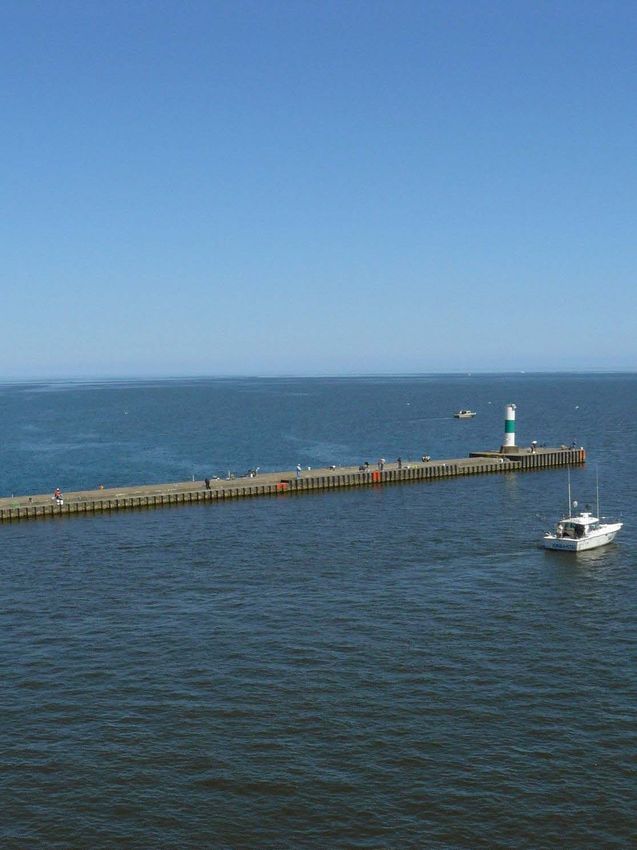
Published by the                                            Venice Inlet. The pier is marked at its end by two fixed red lights.
                                                                              Gasparilla Pass between Gasparilla Island and Little Gasparilla
  National Oceanic and Atmospheric Administration                             Island affords passage from the Gulf to Gasparilla Sound, Placida Harbor,
              National Ocean Service                                          and the Intracoastal Waterway. Local knowledge is needed to carry the
               Office of Coast Survey                                         deepest water. In 2003, the reported controlling depth over the bar
                                                                              through the unmarked channel was 3.5 feet.
           www.NauticalCharts.NOAA.gov                                        Stump Pass, 6 miles N of Gasparilla Pass, between Knight Island and
                   888-990-NOAA                                               Manasota Key, affords passage from the Gulf into the S end of Lemon
                                                                              Bay and the Intracoastal Waterway. The channel is subject to frequent
                      What are Nautical Charts?                               change and should not be attempted without local knowledge. A private
                                                                              light with a daymark reading “Danger Navigate with Local Knowledge
Nautical charts are a fundamental tool of marine navigation. They show        Only” marks the approach.
water depths, obstructions, buoys, other aids to navigation, and much         Venice Inlet, about 26 miles NW of Port Boca Grande, affords a passage
more. The information is shown in a way that promotes safe and                from the Gulf to the Intracoastal Waterway, Roberts, Dona, and Lyons
efficient navigation. Chart carriage is mandatory on the commercial           Bays. A dredged channel leads E from the Gulf between parallel jetties
ships that carry America’s commerce. They are also used on every Navy         for about 0.5 mile to the Intracoastal Waterway. In 2008, the controlling
and Coast Guard ship, fishing and passenger vessels, and are widely           depth in the channel was 5.7 feet. Daybeacons mark the channel. Venice
carried by recreational boaters.                                              Inlet Light 1 (27°06'46"N., 82°28'12"W.), 20 feet above the water, is
                                                                              shown from a a pile with a square green daymark.
                      What is a BookletChart?
                                                                              An unmarked fish haven is about 1 mile SW of Venice Inlet.
This BookletChart is made to help recreational boaters locate                 Midnight Pass, 6 miles NNW from Venice Inlet, between Casey Key and
themselves on the water. It has been reduced in scale for convenience,        Siesta Key, once afforded a passage from the Gulf to Little Sarasota
but otherwise contains all the information of the full-scale nautical         Bay and the Intracoastal Waterway. In 1988, it was reported that this
chart. The bar scales have also been reduced, and are accurate when           the pass is so closed that it can not be discerned from either the Gulf
used to measure distances in this BookletChart. See the Note at the           side or from Little Sarasota Bay.
bottom of page 5 for the reduction in scale applied to this chart.            Currents.–In Midnight Pass the flood current sets NE with an average
                                                                              velocity of 1.8 knots, and the ebb sets SW at an average velocity of 1.4
Whenever possible, use the official, full scale NOAA nautical chart for
                                                                              knots.
navigation. Nautical chart sales agents are listed on the Internet at
                                                                              Big Sarasota Pass, 12 miles NNW from Venice Inlet, leads from the Gulf
http://www.NauticalCharts.NOAA.gov.
                                                                              of Mexico to the S end of Sarasota Bay and the Intracoastal Waterway.
This BookletChart does NOT fulfill chart carriage requirements for            The pass lies between Siesta Key and Lido Key, and is marked by lights
regulated commercial vessels under Titles 33 and 44 of the Code of            and daybeacons. A light marks the channel approach. In 2002, the
Federal Regulations.                                                          reported controlling depth was 4.4 feet in the approach channel; thence
                                                                              in 1999, less than 5 feet was reported through the pass. The approach
                Notice to Mariners Correction Status                          channel over the bar and the channel through the pass are subject to
                                                                              continual changes. Mariners are advised to exercise extreme caution.
This BookletChart has been updated for chart corrections published in
                                                                              Several large hotel buildings at the S end of Lido Key and along the shore
the U.S. Coast Guard Local Notice to Mariners, the National Geospatial
                                                                              of Siesta Key are prominent.
Intelligence Agency Weekly Notice to Mariners, and, where applicable,
                                                                              In 1980, a submerged wreck was reported in the channel approach in
the Canadian Coast Guard Notice to Mariners. Additional chart
                                                                              about 27°16'26"N., 82°34'25"W. Caution is advised while navigating in
corrections have been made by NOAA in advance of their publication in
                                                                              the area.
a Notice to Mariners. The last Notices to Mariners applied to this chart
                                                                              Three fish havens marked by buoys are from 1.1 to 2.2 miles offshore
are listed in the Note at the bottom of page 7. Coast Pilot excerpts are
                                                                              between Big Sarasota Pass and New Pass.
not being corrected.
                                                                              New Pass, 2 miles NNW from Big Sarasota Pass, between Lido
                                                                              Key and Longboat Key, affords passage from the Gulf of Mexico to
For latest Coast Pilot excerpt visit the Office of Coast Survey website at
                                                                              Sarasota Bay and the Intracoastal Waterway. A dredged channel leads
http://www.nauticalcharts.noaa.gov/nsd/searchbychart.php?chart=114
                                                                              from the Gulf through the pass and crosses the Intracoastal Waterway
24.
                                                                              to a turning basin at Centennial Park. The channel approach is marked
                                                                              by a light, and the channel is marked by a light, buoys, and daybeacons.
                              (Selected Excerpts from Coast Pilot)
                                                                              In 2010, aids to navigation were relocated to mark the best water in the
                             The coast between Charlotte Harbor and
                                                                              entrance channel to Light 7 due to shoaling to bare, thence the
                             Tampa Bay trends about NW by N, and has
                                                                              controlling depth was 7.4 feet (8 feet at midchannel) to the highway
                             a nearly straight sand beach that is broken
                                                                              bridge, thence 5.6 feet (6.4 feet at midchannel) to the Intracoastal
                             in places by small inlets. Back of the barrier
                                                                              Waterway, thence 8 feet in the remainder of the channel, thence 7.4 to
                             islands are shallow bays and lagoons which
                                                                              8.0 feet in the turning basin except for lesser depths at the E end of the
                             can be entered from the Gulf of Mexico
                                                                              basin. The channel is subject to shoaling; local knowledge is advised.
                             through Gasparilla Pass, Stump Pass,
                             Venice Inlet, Big Sarasota Pass, New Pass,
                             and Longboat Pass. Most of these passes,                   U.S. Coast Guard Rescue Coordination Center
                             though marked, are subject to change, and                   24 hour Regional Contact for Emergencies
                             the aids are frequently shifted in position.
The low shore is wooded nearly to the water’s edge and has few                       RCC New Orleans         Commander
                                                                                                             8th CG District     (504) 589-6225

                                                                              2
prominent features except near Boca Grande, Venice, and Sarasota, and
for the 720-foot Venice Fishing Pier, about 2.5 miles S of the entrance to                                   New Orleans, LA
BookletChart Lemon Bay to Passage Key Inlet - NOAA Chart 11424 - National ...
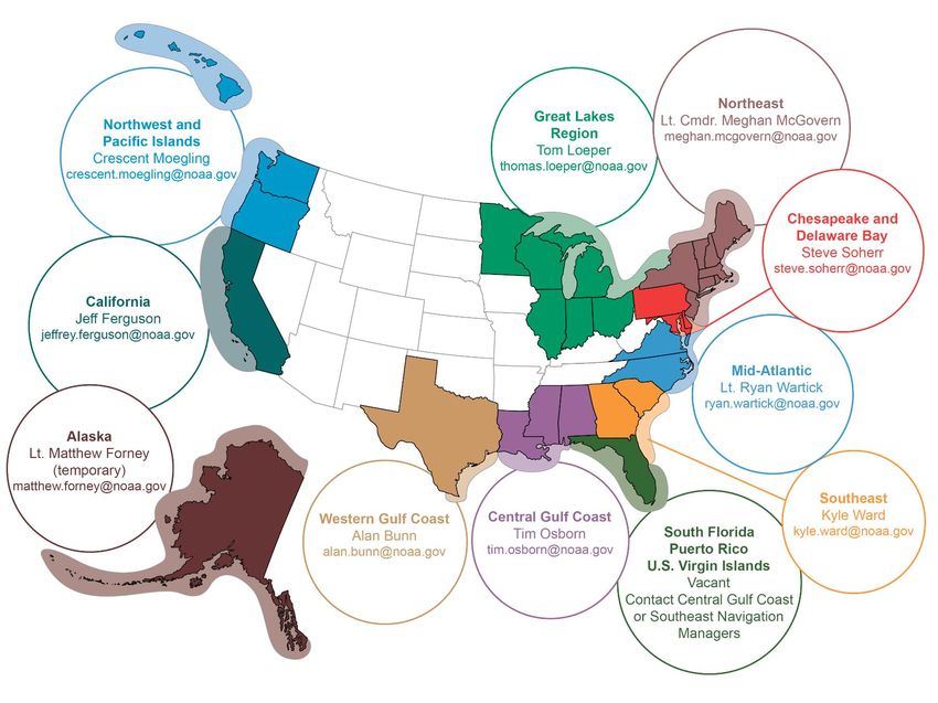
Navigation Managers Area of Responsibility

                                                                                                                                               Northeast
                                                                                                   Great Lakes Region                    Lt. Meghan McGovern
                                                                                                       Tom Loeper                     meghan.mcgovern@noaa.gov
       Northwest and                                                                            thomas.loeper@noaa.gov
       Pacific Islands
      Crescent Moegling
 crescent.moegling@noaa.gov

                                                                                                                                                     Chesapeake and
                                                                                                                                                      Delaware Bay
                                                                                                                                                       Steve Soherr
                                                                                                                                                  steve.soherr@noaa.gov

                            California
                          Jeff Ferguson
                  jeffrey.ferguson@noaa.gov                                                                                                Mid-Atlantic
                                                                                                                                         Lt. Ryan Wartick
                                                                                                                                      ryan.wartick@noaa.gov

                                                                 Western Gulf Coast                                                                          Southeast
                                                                      Alan Bunn            Central Gulf Coast                                                Kyle Ward
           Alaska                                                                             Tim Osborn
                                                                 alan.bunn@noaa.gov                                              South Florida          kyle.ward@noaa.gov
    Lt. Timothy M. Smith                                                                 tim.osborn@noaa.gov
 timothy.m.smith@noaa.gov                                                                                                         Puerto Rico
                                                                                                                              U.S. Virgin Islands
                                                                                                                              Michael Henderson
                                                                                                                         michael.henderson@noaa.gov

NOAA’s navigation managers serve as ambassadors to the maritime community.
They help identify navigational challenges facing professional and recreational mariners, and provide NOAA resources and
information for safe navigation. For additional information, please visit nauticalcharts.noaa.gov/service/navmanagers

To make suggestions or ask questions online, go to nauticalcharts.noaa.gov/inquiry.
To report a chart discrepancy, please use ocsdata.ncd.noaa.gov/idrs/discrepancy.aspx.

Lateral System As Seen Entering From Seaward
on navigable waters except Western Rivers

            PORT SIDE                              PREFERRED CHANNEL                               PREFERRED CHANNEL                                STARBOARD SIDE
        ODD NUMBERED AIDS                     NO NUMBERS – MAY BE LETTERED                    NO NUMBERS – MAY BE LETTERED                        EVEN NUMBERED AIDS
                                                  PREFERRED CHANNEL TO                               PREFERRED CHANNEL
                       GREEN LIGHT ONLY                STARBOARD                                          TO PORT                                                RED LIGHT ONLY
                       FLASHING (2)                TOPMOST BAND GREEN                                 TOPMOST BAND RED                                           FLASHING (2)
                       FLASHING                                                                                                                                  FLASHING
                       OCCULTING                      GREEN LIGHT ONLY                                         RED LIGHT ONLY                                    OCCULTING
                       QUICK FLASHING                                                                                                                            QUICK FLASHING
                       ISO                    COMPOSITE GROUP FLASHING (2+1)                 COMPOSITE GROUP FLASHING (2+1)                                      ISO

                                                                                                                                                                          8

   1                                                                                                                                              2
                                                                                                                                                              "2"
                                                                                                                                                           Fl R 6s
                                                                                                                                                                               R "8"
                                                                                                                                                                              Fl R 4s

                "1"                G "9"                             GR "A"                             RG "B"
             Fl G 6s              Fl G 4s                        Fl (2+1) G 6s                      Fl (2+1) R 6s
                                                                                                                                                                 LIGHTED BUOY
  LIGHT                LIGHTED BUOY                                                                                                              LIGHT

           G
                           5           G          U                                            C
                                                                                                                     G
                                                                                                                                                    6
          C "1"                       "5"
                                                           GR
                                                           "U"                    GR                    RG
                                                                                                       N "C"
                                                                                                                                RG
                                                                                                                                "G"
                                                                                                                                                          R              2         R
                                                                                                                                                                                  "2
                                                                                 C "S"                                                                   N "6"
                                                                                                                                                                                  "

  CAN                   DAYBEACON                                        CAN                  NUN                                                NUN                 DAYBEACON

For more information on aids to navigation, including those on Western Rivers, please consult the latest USCG Light List for your area.
These volumes are available online at http://www.navcen.uscg.gov
BookletChart Lemon Bay to Passage Key Inlet - NOAA Chart 11424 - National ...
VHF Marine Radio channels for use on the
                          waterways:                                                            Distress Call Procedures
                         Channel 6 – Inter-ship safety communications.
                         Channel 9 – Communications between boats and                   • Make sure radio is on.
                         ship-to-coast.                                                 • Select Channel 16.
                         Channel 13 – Navigation purposes at bridges, locks, and        • Press/Hold the transmit button.
                         harbors.                                                       • Clearly say: “MAYDAY, MAYDAY, MAYDAY.”
 EMERGENCY INFORMATION                                                                  • Also give: Vessel Name and/or Description;
                         Channel 16 – Emergency, distress and safety calls to
                         Coast Guard and others, and to initiate calls to other         Position and/or Location; Nature of
vessels. Contact the other vessel, agree to another channel, and then switch.           Emergency; Number of People on Board.
Channel 22A – Calls between the Coast Guard and the public. Severe weather              • Release transmit button.
warnings, hazards to navigation and safety warnings are broadcast here.                 • Wait for 10 seconds — If no response
Channels 68, 69, 71, 72 and 78A – Recreational boat channels.                           Repeat MAYDAY call.

Getting and Giving Help — Signal other boaters using visual distress signals (flares,
                                                                                         HAVE ALL PERSONS PUT ON LIFE JACKETS!
orange flag, lights, arm signals); whistles; horns; and on your VHF radio. You are
required by law to help boaters in trouble. Respond to distress signals, but do not
endanger yourself.

                       NOAA Weather Radio All Hazards (NWR) is a nationwide network of radio stations broadcasting continuous
                       weather information directly from the nearest National Weather Service office. NWR broadcasts official Weather
                       Service warnings, watches, forecasts and other hazard information 24 hours a day, 7 days a week.
                       http://www.nws.noaa.gov/nwr/

                                                         Quick References
     Nautical chart related products and information - http://www.nauticalcharts.noaa.gov

QR
                             Interactive chart catalog - http://www.charts.noaa.gov/InteractiveCatalog/nrnc.shtml
                           Report a chart discrepancy - http://ocsdata.ncd.noaa.gov/idrs/discrepancy.aspx
    Chart and chart related inquiries and comments - http://ocsdata.ncd.noaa.gov/idrs/inquiry.aspx?frompage=ContactUs
            Chart updates (LNM and NM corrections) - http://www.nauticalcharts.noaa.gov/mcd/updates/LNM_NM.html
                                     Coast Pilot online - http://www.nauticalcharts.noaa.gov/nsd/cpdownload.htm
                                    Tides and Currents - http://tidesandcurrents.noaa.gov
                                     Marine Forecasts - http://www.nws.noaa.gov/om/marine/home.htm
                           National Data Buoy Center - http://www.ndbc.noaa.gov/
         NowCoast web portal for coastal conditions - http://www.nowcoast.noaa.gov/
                            National Weather Service - http://www.weather.gov/
                             National Hurrican Center - http://www.nhc.noaa.gov/
                      Pacific Tsunami Warning Center - http://ptwc.weather.gov/
                                            Contact Us - http://www.nauticalcharts.noaa.gov/staff/contact.htm

                                                        For the latest news from Coast Survey, follow @NOAAcharts

                  This Booklet chart has been designed for duplex printing (printed on front and back of one sheet). If a duplex option
                  is not available on your printer, you may print each sheet and arrange them back-to-back to allow for the proper
                  layout when viewing.

                      NOAA’s Office of Coast Survey                           The Nation’s Chartmaker
You can also read