Brief - Fondazione Eni Enrico Mattei
←
→
Page content transcription
If your browser does not render page correctly, please read the page content below
02 | May 2021

      Brief
Extended urbanisation and Covid-19
in Northern Italian Labour Market
Areas: what density tells for municipal
resilience

Elia Silvestro, Fondazione Eni Enrico Mattei

Abstract
FEEM Policy Brief

Extended urbanisation has emerged in the contemporary debate as a notion embracing the
globalised nature of urban phenomena. This includes how urbanisation exerts an influence beyond
the city’s limits, often in places far beyond dense population centres, through a global network
connecting geographically distant areas. With its sprawling urbanisation patterns and a globalised
industrialisation and economy, Northern Italy perfectly fits within this definition. The context of
extended urbanisation is also at the core of the theoretical framework provided by a range of studies
devoted to the spatialities of infectious disease (Connolly, Keil, and Ali 2020; Connolly, Ali, and
Keil 2020). A spatial analysis of excess mortality during the first wave of Covid-19 in Northern Italy
is proposed at the scale of Labour Market Areas (LMAs – Sistemi Locali del Lavoro), with specific
attention to density. More in detail, some topological density indices relating to relational intensity
and territorial permeability are correlated with 2020 COVID-related deaths, that is, excess deaths
compared to the previous five years. This analysis allows combining a snapshot of the contemporary
situation with an overview of inter-area disparities. This can highlight the chronic weaknesses of
different territorial development models and inform resilience strategies at the inter-municipal scale.

ISBN 9791280348098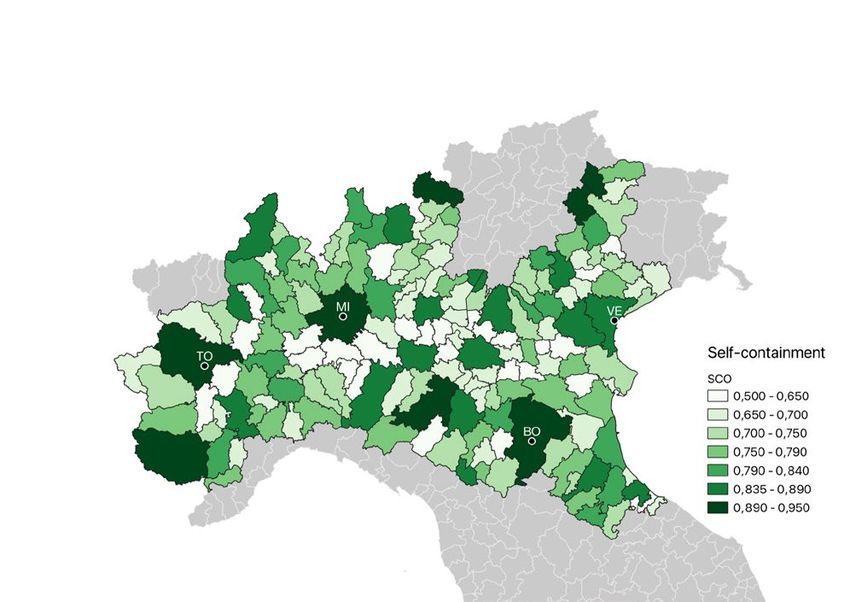
01
Extended urbanisation, density and disease

More space for the urban                           clustering and collective cohabitation of people
process: extended urbanisation                     in space’ (Soja 2000, xii), embracing areas and
Both data and urbanisation narratives describe     flows that need to be accounted for in urban
our century as the most urban one in human         analyses but are often not classified as such.
history, with the UN famously stating that
urban settlements have hosted more than            Following Soja’s lines, Brenner and
half the world’s population since 2007 (UN-        Schmid introduce the concept of extended
Habitat 2006, iv). However, there is a lack of     urbanisation, a component of a three-moment
consensus on how to label some contemporary        urbanisation process of concentrated, extended
manifestations of the urban, not only because      and differential urbanisation. Extended
of the widely varying definitions of urban         urbanisation features such processes as “the
areas (UNDESA 2018, 16) but, some argue,           operationalisation of places, territories and
because of the lack of awareness as to what        landscapes … far beyond the dense population
the urban means. This short-sightedness is         centres”, “the ongoing construction and
labelled ‘methodological cityism’ (Angelo and      reorganization of … infrastructure in support of
Wachsmuth 2015), a bias that leads to ignoring     these operations”, and “the enclosure of land
the broader territory cities affect beyond         from social uses in favour of … profit” (Brenner
traditional urban boundaries (Brenner and          and Schmid 2015, 167).
Schmid 2015, 157).
                                                   The spatial transformations Brenner and
This persists in spite of a decades-long           Schmid list help find the places where the flows
debate on the emergence of a new urban             and relations of contemporary urbanisation
question that has been going on since the          are located. This way, we reverse-engineer
post-war period, notably with Henri Lefebvre       the question: it makes sense to look for the
predicting the advent of ‘complete urbanisation’   areas where processes, flows, relations,
(1970). Another key advancement was Soja’s         lifestyles, etc. that can be defined urban take
‘postmetropolis’ (Soja 2000), an umbrella          place – especially considering that some
term summarising the discourses relating to        traditional combinations, such as urbanity and
the emergent urbanisation processes of the         density, have been disentangled (Keil 2017,
late twentieth century. Soja also introduced       chap. 8). The phenomenology authors use to
the notion of synekism, ‘the economic and          illustrate extended urbanisation shows striking
ecological interdependencies and the creative      similarities with developed countries, such as
… synergisms that arise from the purposeful        the North Italian case.

2   | FEEM BRIEF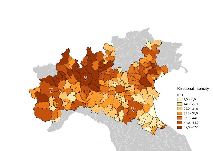
Density: the ever-evolving                          counterpart, is aptly exemplified here as ‘the
category of the urban                               density of a city market or busy train or bus
The contested nature of the urban is reflected      terminal or activist occupation, where the form
in the categories used to define it. Among them,    of order that is put in place is there precisely to
density holds a special place: it is a ‘central     allow for change in relations (over a day or week
terrain for negotiation of what is urban and        or season)’.
what is not […] through the political and social
ecology of boundary setting exercises’ (Keil        This should not lure us into doing away with
2017, chap. 8).                                     topographical density as integral to urban
                                                    studies, but rather making room for what is
When picturing a city, density immediately          possibly the most distinctive feature of the
springs to mind as the common denominator           globalised world: flows. The first ‘point of
of the embodiment of the urban environment.         departure for understanding density’ proposed
Clusters of people, buildings and infrastructure    by McFarlane are ‘the relations that make and
are the physical and abstract agglomeration         unmake density’ (2016, 632), conveyed by the
that builds and keeps cities alive. Static          infrastructures that serve the needs of urban
density metrics are useful metrics for bringing     mobility (as well as energy provision, water
aspects of extended urbanisation to light; but if   sanitation, etc.). Put another way, these areas
extended urbanisation is at least as mobile as      become the linchpin of these flows and the
it is embodied in static infrastructure, ignoring   true core of globalised urbanisation (Connolly,
this mobility would mean missing a crucial part     Keil, and Ali 2020). Now, there is an aspect of
of the picture.                                     urbanisation whose relationship with the many
                                                    facets of density can be revealing: disease.
We can start by looking for a fitting
philosophical framework in terms of time and        Density and/as disease
space. In his reflection on global cities, Smith    Urbanisation is so deeply linked with disease
(2003, 564) writes that ‘space is folded into       that infections have been theorised to have
everything […] geographical scales are little       emerged thanks to the development of
more than straitjackets and space should be         villages, where humans and livestock were
set free’. This resonates in McFarlane’s fresh      in close proximity (Diamond 1997). Cities
look at urban density. He states that density       have subsequently been associated with
‘emerges not just as a topographical, linear,       poor hygiene conditions and disease spread
or numerical problem, but as a topological          for much of human history. It wasn’t until the
problem connecting multiple concerns and            1950s, with great advancements such as
spaces in ways that have consequences               better water sanitation, that the gap closed
for other spaces, some planned and some             (Davis 1965, 44). This turning point from
unplanned’ (McFarlane 2016, 631, emphasis           epidemics to degenerative diseases was
by the author). Topological density, a seemingly    labelled by Omran (1971) as the ‘epidemiologic
more complex notion than its topographical          transition’.

3   | FEEM BRIEF
While cities were becoming havens of networks of the global economy. What can
public health, though, a large-scale shift in be derived, and what evidence might show in
urbanisation patterns magnified the so-called the case of Covid-19, is that the topological
diseases of affluence. Urban sprawl and densities inherent to these infrastructures
suburbanisation, made possible by increasing might be instrumental in the spread of
car ownership and promoted to sustain pandemics. An important dimension is what
demand for products as the automobile (Harvey Keil (2018) calls the ‘global suburb’, a sub-
1985, 122), resulted in sedentary lifestyles, network that turns out to have a life of its own.
water quality degradation and the expansion of Suburban (or, as it were, extended-urban) ways
the urban heat island. of life have as much to do, in health terms, with
what is going on in their global counterparts
In the era of globalisation, exploding as with the life of the metropolitan centres
international trade and mobility co-star in (Connolly, Keil, and Ali 2020). This is apparent
the explosion of pandemics. Keeping in mind in cases such as the recent SARS and Ebola
Brenner and Schmid’s (2015, 167) features outbreaks, which originated in the hinterlands
of extended urbanisation, it is apparent and only later spread elsewhere through the
that communication and transportation global network (Keil and Ali 2007), in a deadly
infrastructure, the loci of extended mix of traditional customs and the expansion
urbanisation, are key in the process. Fixed of global capitalism linking global hubs and
infrastructure helps to absorb more and more remote villages (WHO 2015).
topographical space into the topological
4 | FEEM BRIEF02
A metropolitan archipelago: extended urbanisation in
Northern Italy
In the complexity of the global extended SMEs have contributed to shaping the
urbanisation trend, we concentrate on the morphology of urbanisation, encouraging
highly urbanised region of the Po valley in sprawling housing and industrial areas, via
Northern Italy. This allows for a more uniform lax municipal and regional legislation (Savino
interpretation and creates a context for policy 2009), leading to congested roads, fragmented
insights. manufacturing systems and unplanned
strips where incompatible activities stand
Piedmont (Piemonte), Lombardy (Lombardia), side by side. In what the urbanist Francesco
Emilia-Romagna and Veneto are the four largest Indovina (1990) labelled ‘diffuse city’ (‘città
administrative regions of Northern Italy. Their diffusa’) and later ‘metropolitan archipelago’
recent history sets them apart as the national (2009), topographical density is replaced
economic powerhouse. Thanks to investments by accessibility through mobility, creating
in key manufacturing sectors of the heavy attractive markets for private services. The
industry, in the early twentieth century, north- result is a city in functional and social terms,
western Italy formed the ‘industrial triangle’ but not in physical form. The metropolitan
(Felice 2015). Against the background of a archipelago comes with its drawbacks in terms
socio-economic divide between Northern and of reduced efficiency, with heavy motorisation
Southern Italy, other regions of North-eastern rates, long travel times, environmental
and Central Italy caught up in the following depletion, high energy consumption, high costs
decades. The economic boom, which shrank for public services provision, as well as social
this gap, was fuelled by a different model of isolation for disadvantaged demographics.
development. Third Italy (Bagnasco 1977) did
not owe its fortune to Fordist industrialisation, Leaving aside value judgements, urbanisation
but rather to small and medium-sized in the Po valley is a prime case of extended
enterprises (SMEs), which later developed urbanisation. With its combination of sprawl
into today’s ‘pocket-sized multinationals’ (Colli and high levels of relations, daily activities take
2002). place both on a local and a metropolitan level.
Substantial differences between urban and
This explains both why Northern Italy hosts suburban lifestyles and landscapes disappear,
just shy of 50% of the Italian population and and metropolitan networks become denser
how the population is spread. Globalised with the support of hubs and infrastructures.
5 | FEEM BRIEFTopographical density is less significant, with Thanks to a more dynamic job market, LMAs
dense and less dense, rural and urban areas tend to be larger in Northern Italy as opposed
equally contributing to the production of the to Southern Italy, with higher mobility flow rates
urban (Balducci, Curci, and Fedeli 2019, 53). and a trend of expansion (Cruciani et al. 2015).
Recreational mobility becomes more relevant, Lower rates of supply self-containment (the
and an overall increase in mobility is observed, ratio of internal commutes and residents in
notably where density is lower (Balducci, employment) are observed in peri-urban areas,
Fedeli, and Curci 2017, 53). In general terms, where major urban centres most strongly exert
monocentric metropolitan mobility perspectives their attraction, resulting in higher LMA porosity
prove inadequate, with strongly polycentric (Cruciani et al. 2015, 102). A peculiar feature
functional urban areas. of some LMAs in Lombardy is the sprawling job
supply, with a lower concentration of jobs in the
A final perspective is offered by studies at LMA core city than usual (Cruciani et al. 2015,
the scale of Labour Market Areas (LMAs, SLL 119). There is also a strong prevalence of
or ‘Sistemi Locali del Lavoro’ in Italian) the inflows and outflows of LMAs in Lombardy and
‘regional geographical areas where the bulk Veneto. The same happens with the seven-type
of the labour force lives and works, and where classification of LMAs proposed by Benassi
establishments can find the main part of the and Lipizzi (2015), where ‘diffuse city’ LMAs
labour force necessary to occupy the offered generate high commuting rates, reaching 26.7%
jobs […] the key criterion being the proportion against a national average of 19.1%.
of commuters who cross the LMA boundary on
their way to work’ (ISTAT 2019).
6 | FEEM BRIEF03
Topological density and Covid-19 in Northern Italy
Extended urbanisation in Northern Italy has De Vidovich, and Keil (2020) put it, ‘where the
long been under the eye of experts. As for many virus is concentrated, you find the peripheral’.
other global regions, however, the Covid-19
pandemic was a first-ever event. Besides a few However surprising, these patterns are
cases from Chinese tourists, the first officially plausible in topological terms. Topographical
recognised Italian outbreaks of Covid-19 were density does not seem to accurately describe
reported in little towns in Lombardy and Veneto. Covid-19 spread, as a study focusing on the
While Italian nationals were being repatriated Bergamo area finds out (Cremaschi, Salone,
in a rush, the virus had already made its way and Besana 2021). The authors also highlight
through global mobility. that the combined effect of relational networks
and (hyper)mobility infrastructure is something
As the pandemic began to spread over Italy, existing local institutions are unsuitable to cope
unexpected patterns surfaced, with a clear with. This failure in pandemic governance has
distinction between heavily infected and spurred several proposals for more effective
relatively unaffected regions. ISTAT’s report territorial scales for containing outbreaks.
(ISTAT 2020b) on the impact of Covid-19 The Italian economic think-tank Tortuga has
in the first quarter of 2020 is unequivocal. suggested that Labour Market Areas would
The first nine provinces (Italy’s intermediate be an effective territorial division for localised
administrative entities between municipalities lockdowns (Tortuga 2020). Their argument
and regions) with the highest mortality excess is that, by construction, LMAs enclose areas
are in Lombardy or Emilia-Romagna. Northern where most home-to-work commutes of
Italy had an increase in deaths of 94% in March residents take place – a mobility bubble, as it
2020 compared to the 2015-2019 average, were. LMAs are a reasonable approximation
roughly ten times as much as Central Italy of outbreak areas, and LMA-based lockdowns
(9,1%) and fifty times as much as Southern would be less disruptive than alternatives
Italy (2%). What’s most interesting, however, is based on arbitrary administrative subdivisions.
how the pandemic spread within the hardest- Other studies suggest clusters of LMAs called
hit area. Instead of ravaging the urban cores of ‘Economic Regions’ where an even higher rate
Italy’s big cities, Covid-19’s first wave took its of mobility is self-contained (Anitori et al. 2020).
toll on areas such as Bergamo and the Seriana
Valley, one of the many in-between heavily Building on Tortuga’s and Anitori et al.’s
industrialised regions in the metropolitan region intuitions, we argue that topological densities
surrounding Milan (Barcella 2020). As Biglieri, generated by daily mobility are more
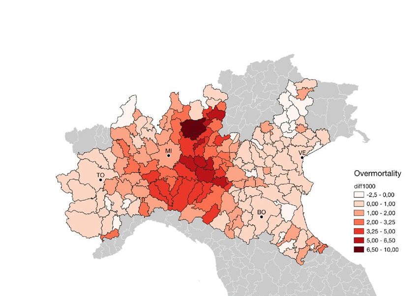
7 | FEEM BRIEFinformative than topographical densities regional public health performance during the
in describing Covid-19 spread in areas of pandemic. Map visualisations offer another
extended urbanisation. We investigate this perspective on results. The excess mortality
possibility quantitatively using IIRFL (Relational map (Figure 1) highlights that hardest-hit LMAs
Intensity Index within LMAs) and SCO (supply- are indeed those around major urban areas
side self-containment), two ISTAT-produced and not the largest cities themselves, with
Labour Market Areas quality indicators (ISTAT Milan’s large LMA showing a lighter shade
2020a) as proxies of relational intensity within than Eastern Lombardian and Emilian LMAs
and in relation to neighbouring LMAs. surrounding it. The IIRFL map (Figure 2) shows
a less unmistakable pattern. However, it shows
The results are encouraging. Correlating how high IIRFL values spread well beyond
these indices with excess mortality in the metropolitan cores (e.g., in Lombardy) and
months of the first wave of Covid-19 pandemic are sometimes higher for peri-urban areas
exposes the influence of topological density than for the metropolitan core itself (e.g., in
on pandemic spread: areas with higher the north-western region of Piedmont, with
relational intensity – more people commuting higher values north of Turin than for the city’s
to different municipalities – and lower self- LMA itself). Lastly, the self-containment (SCO)
containment – more people commuting outside map shows peri-urban LMAs stand out as
their own Labour Market Area – have higher distinctively porous, with the lowest values in
excess mortality. This still holds when we areas surrounding urban cores in dark green
control for the four different regions studied, (Figure 3).
a crucial factor considering the differences in
Figure 1. Excess mortality by LMA
Overmortality
diff1000
-2.5 - 0.00
0.00 - 1.00
1.00 - 2.00
2.00 - 3.25
3.25 - 5.00
5.00 - 6.50
6.50 - 10.00
8 | FEEM BRIEFFigure 2. Relational intensity (IIRFL index) by LMA
Relational intensity
IIRFL
7.0 - 14.0
14.0 - 22.0
22.0 - 31.0
31.0 - 37.0
37.0 - 44.0
44.0 - 52.0
52.0 - 67.0
Figure 3. Self-containment (SCO index) by LMA
Self-containment
SCO
0.500 - 0.650
0.650 - 0.700
0.700 - 0.750
0.750 - 0.790
0.790 - 0.840
0.835 - 0.890
0.890 - 0.950
9 | FEEM BRIEF04
Policy Conclusion
As the contrasting views of the scientific What can be implied for local policy is that
community suggest, the complexity of there is a lack of awareness and preparation
COVID-19 spread calls for rigorous studies. in public perception and local governance as
Here, we find out that the topological densities to what being part of extended urbanisation
of daily mobility patterns in Northern Italian entails. Another important point is that
municipalities correlate with excess mortality functional areas are still unappreciated as an
during the first wave of Covid-19, consistently effective tool for policies such as lockdown
with the relational and global dimensions of measures, despite the arbitrary nature of
extended urbanisation. Conversely, contrary to jurisdictional delimitations. In this respect, our
common belief, topographical density seems contribution highlights that mobility is key for
unsuitable to find out weak spots for pandemic studying topological densities within functional
outbreaks. areas and LMAs, or larger delimitations based
on LMA clustering, offer rich opportunities for
local governance for building resilience.
10 | FEEM BRIEFReferences
Angelo, Hillary, and David Wachsmuth. 2015. Barcella, Paolo. 2020. ‘Perché Proprio Qui?’
‘Urbanizing Urban Political Ecology: A Critique La Rivista Il Mulino. 18 March 2020. https://
of Methodological Cityism: Urbanizing Urban www.rivistailmulino.it/news/newsitem/index/Item/
Political Ecology’. International Journal of Urban News:NEWS_ITEM:5106.
and Regional Research 39 (1): 16–27. https://doi.
org/10.1111/1468-2427.12105. Benassi, Federico, and Federico Lipizzi. 2015.
‘Il “Paese Reale” Letto Attraverso i Sistemi Locali. Le
Anitori, Paola, Carlo De Gregorio, Alessandra “Specializzazioni” Socio-Demografiche Dei Territori’.
Reale, and Fabio Sforzi. 2020. ‘Determinazione In La Nuova Geografia Dei Sistemi Locali, edited by
Di Aree Economiche per La Valutazione Dell’impatto ISTAT, 143–50. Rome.
Sul Sistema Produttivo Italiano Delle Misure Di
Contrasto All’epidemia Da Covid-19’. MPRA Paper Biglieri, Samantha, Lorenzo De Vidovich, and
101820. University Library of Munich, Germany. Roger Keil. 2020. ‘City as the Core of Contagion?
https://ideas.repec.org/p/pra/mprapa/101820. Repositioning COVID-19 at the Social and Spatial
html. Periphery of Urban Society’. Cities & Health, July,
1–3. https://doi.org/10.1080/23748834.2020.178
Bagnasco, Arnaldo. 1977. Tre Italie: La 8320.
Problematica Territoriale Dello Sviluppo Italiano.
Studi e Ricerche. Il mulino. Brenner, Neil, and Christian Schmid. 2015.
‘Towards a New Epistemology of the Urban?’ City 19
Balducci, Alessandro, Francesco Curci, and (2–3): 151–82.
Valeria Fedeli. 2019. ‘L’urbano Che Cambia
Oltre Le Città e Le Metropoli. Un Contributo Dal Colli, Andrea. 2002. Il Quarto Capitalismo: Un
Contesto Italiano’. Contesti. Città, Territori, Progetti, Profilo Italiano. Grilli Marsilio. Marsilio.
no. 1 (September). https://doi.org/10.13128/
contest-10630. Connolly, Creighton, S Harris Ali, and Roger
Keil. 2020. ‘On the Relationships between
Balducci, Alessandro, Valeria Fedeli, and COVID-19 and Extended Urbanization’. Dialogues
Francesco Curci. 2017. Oltre La Metropoli. in Human Geography 10 (2): 213–16. https://doi.
L’urbanizzazione Regionale in Italia. Il Futuro Delle org/10.1177/2043820620934209.
Città. goWare e Edizioni Angelo Guerini e Associati.
https://books.google.it/books?id=M7DKDgAAQBAJ.
11 | FEEM BRIEFConnolly, Creighton, Roger Keil, and S. Ibid. 2009. ‘La Nuova Dimensione Urbana:
Harris Ali. 2020. ‘Extended Urbanisation and the L’arcipelago Metropolitano’. In Dalla Città Diffusa
Spatialities of Infectious Disease: Demographic All’arcipelago Metropolitano, by Francesco Indovina,
Change, Infrastructure and Governance’. Urban 175–97. Milan: FrancoAngeli.
Studies, March, 0042098020910873. https://doi.
org/10.1177/0042098020910873. ISTAT. 2019. ‘Labour Market Areas’. Istituto
Nazionale Di Statistica. 2019. https://www.istat.it/
Cremaschi, Marco, Carlo Salone, and Angelo en/labour-market-areas.
Besana. 2021. ‘Densità urbana e Covid-19: la
diffusione territoriale del virus nell’area di Bergamo’. Ibid. 2020a. ‘Indicatori di qualità dei sistemi locali
Archivio di studi urbani e regionali LI (130). del lavoro’. Istituto Nazionale di Statistica. 2020.
https://www.francoangeli.it/Riviste/sommario. https://www.istat.it/it/informazioni-territoriali-e-
aspx?IDRivista=3&lingua=EN. cartografiche/sistemi-locali-del-lavoro/indicatori-di-
qualit%C3%A0-sll.
Cruciani, Sandro, Giovanni A. Barbieri, Luisa
Franconi, and Alessandra Ferrara. 2015. ‘La Ibid. 2020b. ‘Impatto Dell’epidemia Covid-19 Sulla
Configurazione Spaziale Dei Sistemi Locali’. In La Mortalità Totale Della Popolazione Residente. Primo
Nuova Geografia Dei Sistemi Locali, edited by ISTAT, Trimestre 2020’.
93–141. Rome.
Keil, Roger. 2017. Suburban Planet: Making the
Davis, Kingsley. 1965. ‘The Urbanization of the World Urban from the Outside In. Urban Futures.
Human Population’. Scientific American 213 (3): Cambridge, UK: Wiley.
40–53.
Ibid. 2018. ‘Extended Urbanization, “Disjunct
Diamond, Jared. 1997. Guns, Germs and Steel: Fragments” and Global Suburbanisms’. Environment
A Short History of Everybody for the Last 13,000 and Planning D: Society and Space 36 (3): 494–
Years. New York: W. W. Norton. 511. https://doi.org/10.1177/0263775817749594.
Harvey, David. 1985. The Urbanization of Capital. Keil, Roger, and Harris Ali. 2007. ‘Governing
The Urbanization of Capital. Studies in the History the Sick City: Urban Governance in the Age
and Theory of Capitalist Urbanization; 2. Oxford: of Emerging Infectious Disease’. Antipode 39
Blackwell. (5): 846–73. https://doi.org/10.1111/j.1467-
8330.2007.00555.x.
Indovina, Francesco. 1990. ‘La Città Diffusa’.
In La Città Diffusa, edited by Francesco Indovina. Lefebvre, Henri. 1970. La révolution urbaine.
Quaderno Daest n.1. Venice: IUAV. Paris: Gallimard.
12 | FEEM BRIEFMcFarlane, Colin. 2016. ‘The Geographies of Tortuga. 2020. ‘Fase 2: Sistemi Locali Del
Urban Density: Topology, Politics and the City’. Lavoro. Un Criterio Geografico per La Riapertura
Progress in Human Geography 40 (5): 629–48. Dopo Covid-19’. https://www.tortuga-econ.
https://doi.org/10.1177/0309132515608694. it/2020/04/26/fase-2-e-sistemi-locali-del-lavoro-
sll/.
Omran, A. R. 1971. ‘The Epidemiologic Transition.
A Theory of the Epidemiology of Population Change.’ UNDESA. 2018. ‘World Urbanization Prospects
The Milbank Memorial Fund Quarterly 49 (4): 2018’. United Nations Department for Economic and
509–38. Social Affiars.
Savino, Michelangelo. 2009. ‘Governare La UN-Habitat. 2006. State of the World’s Cities
Complessità. Il Veneto Come Caso Esemplificativo 2006/7. The Millennium Development Goals and
Ma Non Paradigmatico’. In Dalla Città Diffusa Urban Sustainability: 30 Years of Shaping the
All’arcipelago Metropolitano, by Francesco Indovina. Habitat Agenda. Earthscan London.
Milan: FrancoAngeli.
WHO. 2015. ‘Factors That Contributed to
Smith, Richard G. 2003. ‘World City Topologies’. Undetected Spread of the Ebola Virus and Impeded
Progress in Human Geography 27 (5): 561–82. Rapid Containment’. World Health Organization.
https://doi.org/10.1191/0309132503ph447oa. 2015. http://www.who.int/entity/csr/disease/ebola/
one-year-report/factors/en/index.html.
Soja, Edward W. 2000. Postmetropolis: Critical
Studies of Cities and Regions. Wiley. https://books.
google.it/books?id=mnbrMlu8fSoC.
13 | FEEM BRIEFThe Fondazione Eni Enrico Mattei (FEEM), founded in 1989, is a non profit, policy-oriented, international research center and a think-tank producing high-quality, innovative, interdisciplinary and scientifically sound research on sustainable development. It contributes to the quality of decision-making in public and private spheres through analytical studies, policy advice, scientific dissemination and high-level education. Thanks to its international network, FEEM integrates its research and dissemination activities with those of the best academic institutions and think tanks around the world. Fondazione Eni Enrico Mattei Corso Magenta 63, Milano – Italia Tel. +39 02.520.36934 Fax. +39.02.520.36946 E-mail: letter@feem.it www.feem.it
You can also read