Poole Harbour SSSI Dorset - Supporting Information A supplement to the notification document
←
→
Page content transcription
If your browser does not render page correctly, please read the page content below

Poole Harbour SSSI
                                 Dorset

                            Supporting Information

              A supplement to the notification document

Issued by Natural England’s Dorset, Hampshire and the Isle of Wight Area Team on 24 May 2018
Contact points and further information
This supplement is issued on request by Natural England’s Dorset, Hampshire and the Isle of
Wight Area Team and is intended to be read in conjunction with the notification document for
owners, occupiers and other notified parties. The address for correspondence is:

Natural England
Rivers House,
Sunrise Business Park,
Higher Shaftesbury Road,
Blandford Forum,
DT11 8ST

Telephone number: 0300 060 1821
E-mail:           stephen.treby@naturalengland.org.uk
Online:           https://consult.defra.gov.uk/natural-england/poole-harbour

Your contact point for enquiries relating to this notification is Stephen Treby.

                                                Page 2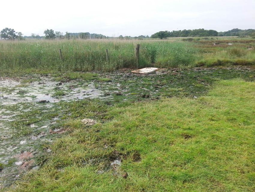
Contents
Summary

1.   Information used to support the extension of Poole Harbour SSSI

2.   Explanation of how the notification of additional land at Poole Harbour meets the SSSI
     selection guidelines

3.   Assessment of the current condition of Poole Harbour SSSI

4.   Selection of operations requiring Natural England’s consent

5.   Site unit map

6.   Photographs and figures

                                           Page 3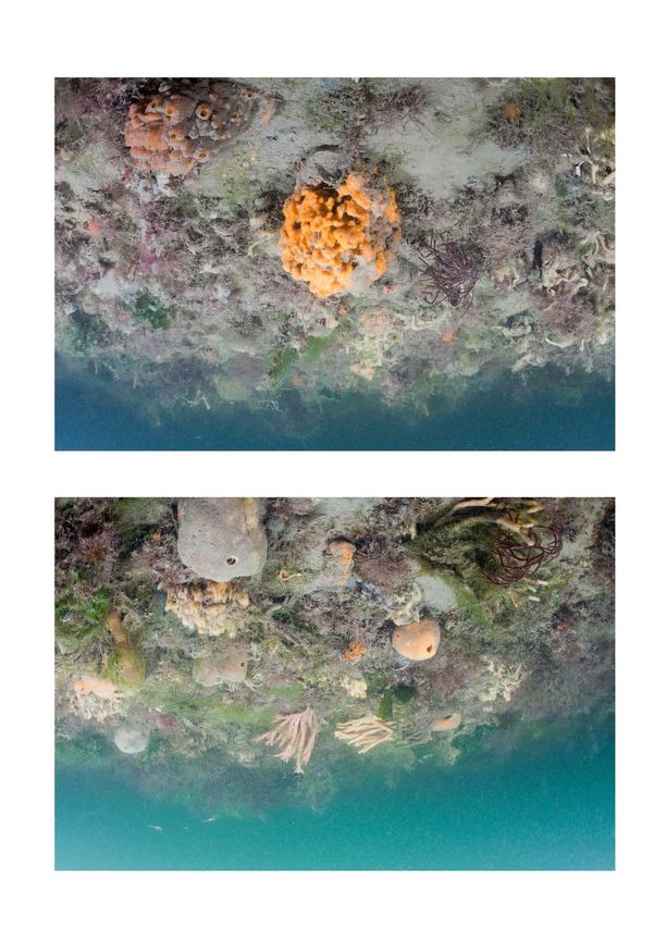
Summary
Poole Harbour was last notified as a Site of Special Scientific Interest (SSSI) on 7 December 1990.
The SSSI has been extended to include four areas of additional land. By far the largest is the
estuarial open water below the Mean Low Water mark (MLW), which extends to the Harbour mouth
in the east and westwards to where the estuary meets the Rivers Piddle and Frome. The other
three areas comprise saltmarsh, wetland and supporting habitats around the fringes of Lytchett
Bay and Holes Bay.
The SSSI continues to be of special interest for its estuarine habitats, including marshes, mudflats
and subtidal communities; fringing terrestrial habitats, including heathlands and grasslands; and
species supported by these habitats, including breeding and wintering birds, lichens, rare
invertebrates and red squirrel Sciurus vulgaris.
All four areas of additional land support estuarine habitats and wintering wildfowl and waders for
which the site is of special interest. The areas lying below MLW also support other features for
which the site is of special interest including foraging habitat for breeding seabirds and subtidal
benthic (seabed) habitats (such as peacock worm Sabella pavonina and eelgrass Zostera marina
beds). Coastal and marine geomorphological processes (including hydrodynamics, sediment
movements and tidal inundation) also operate within this area and these natural processes are
essential for the maintenance of the estuarine habitats, such as saltmarshes and intertidal
mudflats.

                                               Page 4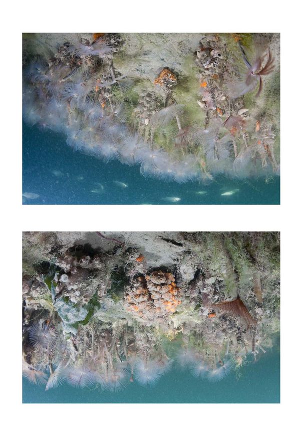
1.        Information used to support the extension of Poole Harbour SSSI
Feature     Data Source                         Author(s)               Date   Content
General    Guidelines for the Selection of      Bainbridge, I.,         2013   National selection
           Biological SSSIs. Part 1:            Brown, A., Burnett,            guidelines for
           Rationale, Operational               N., Corbett, P.,               biological SSSIs
           Approach and Criteria for Site       Cork, C., Ferris, R.,
           Selection. Joint Nature              Howe, M.,
           Conservation Committee               Maddock, A. &
           (JNCC), Peterborough                 Pritchard, S. (eds)
           http://jncc.defra.gov.uk/pdf/SSSI
           _GuidelinesPart1_PUBLICATIO
           N_Dec2013v2.pdf
Birds      Estuary birds of Britain &           Prater, A.J             1981   Evidence of the
           Ireland. Poyser, Calton.                                            importance of lower
                                                                               intertidal habitat for
                                                                               birds foraging
           Coastal Birds of east Dorset.        Aspinall, S. &          1990   Includes tern sighting
           Nature Conservancy Council           Tasker, M.L.                   data within and
           (NCC) report commissioned by                                        outside of Poole
           BP Petroleum Development Ltd                                        Harbour
           http://jncc.defra.gov.uk/page-
           2385
           Bird life of coasts and estuaries.   Ferns, P.N.             1992   Evidence of the
           Cambridge University Press,                                         importance of lower
           Cambridge                                                           intertidal habitat for
                                                                               birds foraging
           Gulls of Poole Harbour.              Hopper, N.              2008   Roost sites for black-
           Published online at                                                 headed gull in open
           http://www.birdsofpooleharbour.                                     water outside the
           co.uk/sites/default/files/Gulls%2                                   previously notified
           0of%20Poole%20H%20copy.pdf                                          SSSI boundary
           Quantifying usage of the marine      Wilson, L.J., Black, 2014      Modelled foraging
           environment by terns Sterna sp.      J., Brewer, M.J.,              area used by tern
           around their breeding colony         Potts, J.M.,                   breeding colonies
           SPAs. JNCC Report No 500             Kuepfer, A., Win, I.,          from Poole Harbour
           http://jncc.defra.gov.uk/page-       Kober, K.,
           6644                                 Bingham, C.,
                                                Mavor, R. & Webb,
                                                A.
           Guidelines for the selection of      Drewitt, A.L.,        2015     Guidelines for
           biological SSSIs. Part 2:            Whitehead, S. &                selection of biological
           Detailed Guidelines for Habitats     Cohen, S.                      SSSIs for bird
           and Species Groups. Chapter                                         features
           17: Birds. JNCC, Peterborough
           http://jncc.defra.gov.uk/pdf/SSSI
           _Chptr17_Birds2015June.pdf
           Wetland Bird Survey (WeBS)           British Trust for       2015   Data on bird usage of
           data 2010/11-2014/15 for Poole       Ornithology (BTO)              Poole Harbour
           Harbour. Report from WeBS
           database

                                                Page 5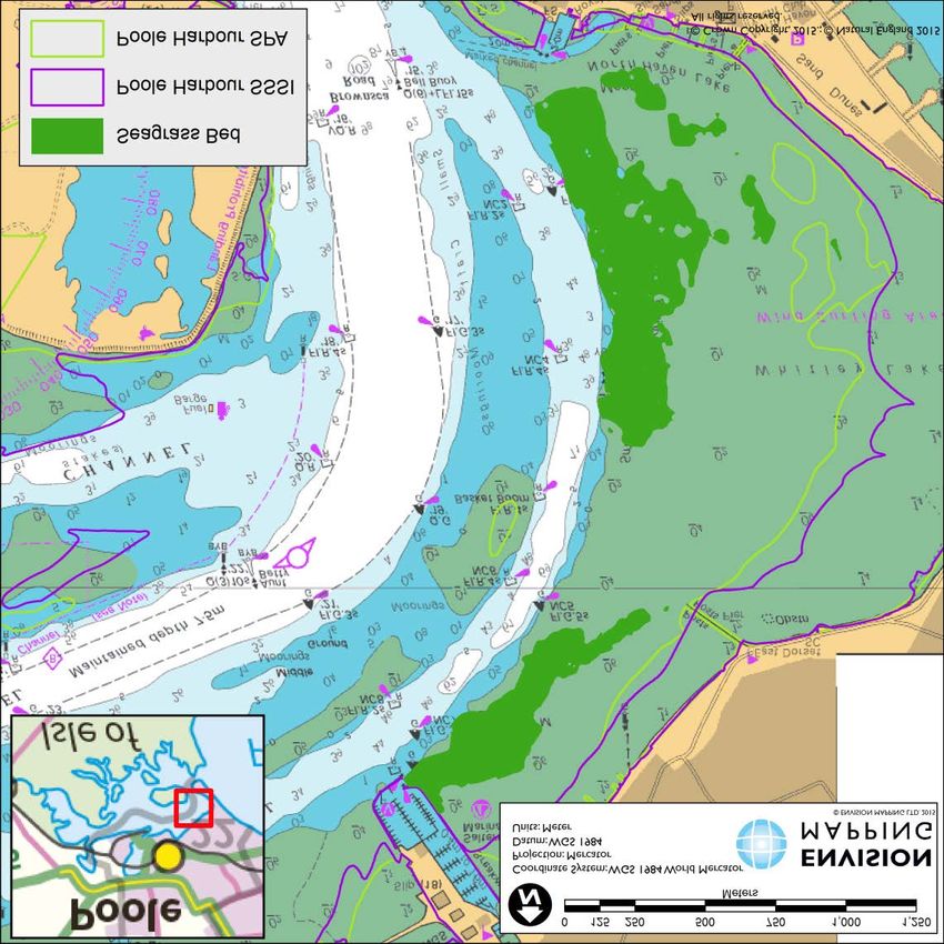
Feature   Data Source                          Author(s)              Date   Content
          Waterbirds in the UK 2013/14:        Holt, C.A., Austin,    2015   Annual report from
          The Wetland Bird Survey.             G.E., Calbrade,               wetland bird survey
          BTO/RSPB/JNCC, Thetford.             N.A., Mellan, H.J.,
          https://www.bto.org/sites/default/   Hearn, R.D.,
          files/wituk-2013-14.pdf              Stroud, D.A.,
                                               Wotton, S.R. &
                                               Musgrove, A.J.
          Waders and Seafowl Roost             Morrison, S.           2015   Water bird roost sites
          survey of Poole Harbour, Dorset                                    including Round
          – Winter 2014/15. Report to                                        Island outside the
          Natural England                                                    previously notified
          https://www.researchgate.net/pu                                    SSSI boundary
          blication/280014490_Wader_an
          d_Seafowl_Roost_Survey_of_P
          oole_Harbour_Dorset_-
          _Winter_201415
          Tern verification surveys for        Perrow, M.R.,          2015   Verification that terns
          marine sites. Final Report by        Harwood, A.J.P. &             forage in busy areas
          ECON Ecological Consultancy          Caldow, R.W.G                 such as docks and
          Limited to Natural England                                         marinas
          http://publications.naturalenglan
          d.org.uk/publication/668836437
          4786048
          Use of marinas and channels by       Liley, D               2017   Observations of the
          terns in Poole Harbour:                                            use by terns of
          Verification survey for Poole                                      various parts of Poole
          Harbour pSPA. Footprint                                            Harbour
          Ecology report to Natural
          England
          RSPB Lytchett Fields peak            S. Robson in litt.     2017   Waterbird counts from
          waterbird counts 2013-15 and                                       Lytchett Fields
          2016/17.
          Specialist support for the           Rowell, H.             2018   Support for the
          notification of additional land in                                 notification from
          the Poole Harbour SSSI                                             Natural England’s
                                                                             ornithologist
Estuary   Guidelines for the Selection of      NCC                    1989   National selection
          Biological SSSIs. Part 2:                                          guidelines for
          Detailed Guidelines for Habitats                                   biological SSSIs (re-
          and Species Groups. Chapter                                        published online by
          1a. Coastlands. NCC,                                               JNCC in 2012)
          Peterborough
          http://jncc.defra.gov.uk/pdf/SSSI
          s_Chapter01.pdf
          Nature conservation and              Davidson, N.C.,        1991   Review of estuaries in
          estuaries in Great Britain.          Laffoley, D.d’A.,             Britain, their attributes
          Peterborough, NCC                    Doody, J.P., Way,             and their conservation
          http://jncc.defra.gov.uk/page-       L., Gordon, J., Key,
          2563                                 R., Pienkowski,
                                               M.W., Mitchell. R.
                                               & Duff, K.
          Benthic Habitats and Species of      Dyrynda, P.            1991   Status and distribution
          Conservation Interest. Report to                                   of Suberites massa
          NCC                                                                and Sabella pavonina
                                                                             beds in Poole Harbour

                                               Page 6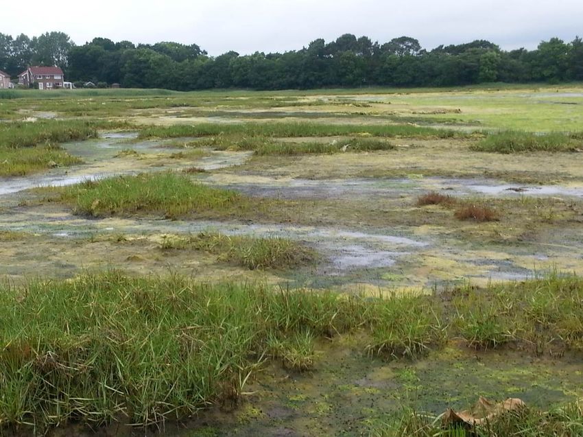
Feature     Data Source                         Author(s)              Date      Content
           The Ecology of Poole Harbour:        Dyrynda, P.            2005      Distribution and status
           8. Subtidal ecology of Poole                                          of subtidal benthic
           Harbour – an overview.                                                (seabed) marine
           Proceedings in Marine Science                                         communities
           7: 109-130.
           Poole Harbour Sabella pavonina       Southern Inshore       2015      Underwater video
           verification survey using            Fisheries and                    survey of Sabella
           Underwater Video Techniques          Conservation                     pavonina
           2015                                 Authority
           Poole Harbour Subtidal Survey -      Baldock, L.            2016      Subtidal surveys of
           Sabella pavonina & Suberites                                          Poole Harbour
           massa. Field Work Update.
           Interim report to Natural
           England
           Specialist support for the           Hiorns,N               2018      Support for the
           notification of additional land in                                    notification from
           the Poole Harbour SSSI                                                Natural England’s
                                                                                 senior marine
                                                                                 specialist

2.     Explanation of how the notification of additional land at Poole
       Harbour meets the SSSI selection guidelines
This section explains how the information listed in section 1 has informed our decision to notify the
additional land, according to the Guidelines for the selection of Biological SSSIs. Part 1: Rationale,
Operational Approach and Criteria for Site Selection (JNCC, 2013) and Part 2: Detailed guidelines
for habitats and species groups, hereafter referred to as ‘the Guidelines’.

2.1    Seaward extension to include estuarial waters below Mean Low Water mark (MLW)
This element of the additional land supports a number of the special interests of the SSSI,
including the estuary itself, subtidal and intertidal habitats, breeding and wintering birds.

2.1.1 Estuarine habitats
The Guidelines (Part 1, Section 8.2) state that:
       ‘SSSI boundaries should be drawn to encompass the special features of the site and all
       land necessary to ensure the sustainability of those features. Consideration should be given
       to the inclusion of whole management units, entire ecological units and supporting
       processes (such as hydrology or sediment supply). Boundaries should take account of
       dynamic processes (such as active coastal and floodplain geomorphology).’
For coastal habitats, the Guidelines (Part 2, Chapter 1a, section 10.2) state:
       ‘Combinations of these sedimentary habitats may also be important because they form
       significant geomorphological units of national or international importance. It is essential
       therefore that estuaries are not selected solely for their ornithological value but are
       recognised for this combination of interests. Site integrity therefore becomes an important
       concept in defining the boundaries of extensive sites.’
The previous seaward boundary of the SSSI was drawn to MLW and subtidal estuarial waters and
lower shore intertidal mudflats were not included. Coastal and marine geomorphological processes
(including hydrodynamics, sediment movements and tidal inundation) occur over the entire
Harbour and are essential for the maintenance of the estuarine habitats (such as saltmarshes and
intertidal mudflats). Notification of the additional land ensures the SSSI includes all the areas within
which these key supporting natural processes occur.
The narrow entrance in relation to the size and shape of the estuary means that it is a relatively
self-contained and well defined ecological unit (see aerial view in photograph 11, section 6).
                                                Page 7
Moreover, the microtidal regime 1 of Poole Harbour means that the extent of the estuarial open
water area relative to the intertidal is much greater than for other English estuaries (which are
predominantly mesotidal and macrotidal). Thus the additional land below MLW is highly significant
in relation to these natural estuarine processes.
The estuarine habitats readily define the seaward and upstream boundaries of the extended SSSI.
The seaward boundary follows the limit of estuarine waters which forms a straight line at the
Harbour mouth, as mapped by the Environment Agency. Similarly, the upstream limits of estuarine
waters (again as mapped by the Environment Agency) on the Rivers Frome and Piddle mark the
upstream limits of the extended SSSI.
The estuarial waters support important subtidal benthic (seabed) habitats in some locations,
although it is important to note that these are not found across the entire Harbour. The subtidal
benthic habitats of particular importance are described below with maps and descriptions of their
current known locations.
High density beds of the peacock worm Sabella pavonina (see photographs 1 and 2 in section 6)
are particularly widespread within certain mid-stream areas of the subtidal channels and are of
particular conservation interest as a habitat for other species (Dyrynda 1991). The species itself is
not rare but Poole Harbour is the best known example where it forms high density beds with a
substantial associated fauna. These beds exhibit a high species richness and diversity, with the
tubes colonised by seaweeds, sponges (including the rare Suberites massa, see photographs 3
and 4 in section 6), bryozoans and ascidians, while crabs and fish are also associated with them
(Dyrynda 1991). A verification survey using underwater video was undertaken in 2015 (Figure 1).
This shows that peacock worm beds were recorded in a couple of locations above MLW (for
instance, at the entrance of Newton Bay) but are predominantly found below MLW.
The sponge Suberites massa is listed as Nationally Rare 2 in the Guidelines (Chapter 1a). It has
been recorded recently in a number of locations associated with artificial structures, in particular
within the Blackwater channel in Holes Bay. It was also recorded as common in a restricted area
in South Deep on the north-west side of Goathorn Point, associated with American slipper limpet
Crepidula fornicata shells (Baldock 2016).
The remaining key estuarine habitat within the additional land is the intertidal sediments, which
comprise a range of biotopes (including areas supporting seagrass beds of eelgrass Zostera
marina) relating to different substrate types, salinities and degrees of wave exposure. No
nationally scarce species or biotopes have been recorded within the intertidal sediments; rather
their value and importance lies in the abundance and biomass of annelid worms and bivalve
molluscs. These invertebrates are a key prey resource for waterfowl (Herbert et al. 2010). The
lower shore intertidal sediments extend significantly seaward beyond MLW at certain tides (Figure
3).
Figure 2 shows the locations of the two main seagrass beds in Poole Harbour, which are an
important habitat of the intertidal estuarine sediments, particularly for fish-eating birds. These
seagrass beds were previously excluded from the SSSI (as shown in Figure 2) as they occupy the
lowest parts of the intertidal zone below MLW which are only exposed on certain tides.
The additional land includes all of the channels supporting peacock worm beds and the sponge
Suberites massa below MLW (Figure 1) and the lower shore intertidal areas supporting important
intertidal sediments (Figure 3), including those with seagrass beds (Figure 2).

1 Microtidal estuaries have a tidal range of less than 2 metres; whilst for mesotidal and macrotidal estuaries,

the tidal range is 2-4 metres and greater than 4 metres, respectively.
2 Nationally Rare species are those found in 1-15 10km x 10km squares of the British National Grid.

                                                     Page 8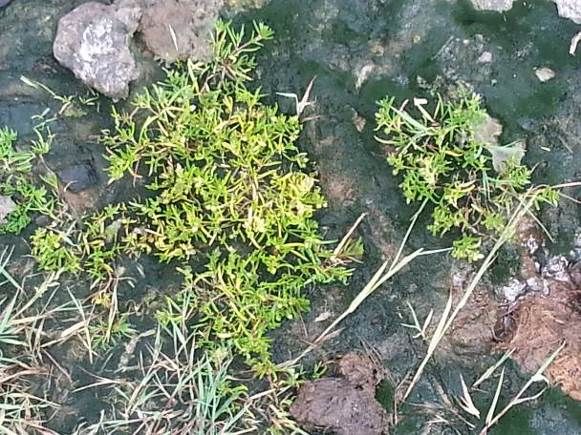
Figure 1: Density of peacock worm Sabella pavonina as percentage cover based on an assessment of screenshots taken from video footage.
                                                                   Page 9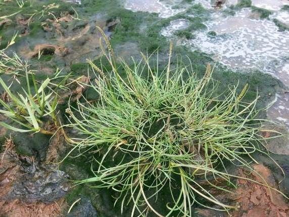
Figure 2: Seagrass beds determined from towed video footage (Envision, 2016). Note that the
‘Poole Harbour SSSI’ and ‘Poole Harbour SPA’ boundaries depicted in this map relate to the
previously notified SSSI (prior to the current additions) and the SPA prior to the extensions
classified in 2017.

                                             Page 10
Figure 3: Intertidal sediments exposed on the lowest tides that lie outside the previously notified Poole Harbour SSSI boundary
Page 112.1.2 Birds
The Guidelines (Part 2, Chapter 17, sections 3.2 and 3.3) state that:
‘Localities which regularly support 1% or more of the total British non-breeding population of
any native species in any season and non-breeding waterbird assemblages of over 20,000
individuals will qualify for SSSI selection.’
‘Localities which regularly support 1% or more of the total British breeding population of any
native species and seabird colonies of over 10,000 breeding pairs will qualify for SSSI
selection.’
The Guidelines (Part 2, Chapter 17, section 3.8) state that:
‘Localities which support an especially good range of bird species characteristic of a
particular habitat, as defined by an index value, will qualify for SSSI selection.’
The SSSI (including the additional land) continues to be of special interest for its important
numbers of at least 14 species of wintering wildfowl and wader, for breeding grey heron Ardea
cinerea and redshank Tringa totanus and for its assemblages of breeding birds associated with
lowland open waters and their margins, sand dunes and saltmarsh.
The Guidelines (Part 1, section 8.9) state that:
‘Intertidal areas…usually present relatively few problems in boundary
definition…Ornithological requirements usually reinforce the need to select the whole of
major systems’
The Guidelines (Part 2, Chapter 17, Section 3.2) state that:
‘Any site considered should normally be large enough to include all the areas required by
the individuals concerned.’
The assessment of the special interest of the SSSI for wintering wildfowl and waders is based
largely on the Wetland Bird Survey (WeBS) which monitors non-breeding waterbirds in the UK.
WeBS counts cover the whole Harbour and do not distinguish between birds using the additional
land and the previously notified SSSI, because many of the count sectors overlap between the two.
As shown in Figure 3 large areas of intertidal mudflats lie below MLW and at certain tides these will
provide an additional area of food resource for wintering waders (such as black-tailed godwit
Limosa limosa, dunlin Calidris alpina and curlew Numenius arquata) and many of the breeding
waterbirds (including redshank ) that forage on intertidal mud. Many birds maximise their limited
time on these lower shore habitats by foraging along the edge of the tide as it recedes (Prater
1981; Ferns 1992).
In addition the areas of estuarial water below MLW are essential for fish-eating species to feed and
to rest (such as wintering goldeneye Bucephala clangula, red-breasted merganser Mergus serrator
and cormorant Phalacrocorax carbo). WeBS counts undertaken at low tide recorded these three
species to be widespread in the Harbour. A key nocturnal roost site for wintering wildfowl is found
off Round Island, with large numbers of red-breasted mergansers, goldeneye and great crested
grebes Podiceps cristatus forming dense aggregations over this area of open water (Morrison
2012), which is within the additional land.
Black-headed gulls Chroicocephalus ridibundus, one of the breeding birds of sand-dunes and
saltmarshes, form roosts on the open water in areas within the additional land (Hopper 2008).
Common and Sandwich terns are also part of the notified breeding bird interest of the SSSI and
are known to forage extensively in the open water within the Harbour, as well as in the open sea
outside the Harbour entrance (Aspinall & Tasker 1990). Recent research by JNCC (Wilson et al.
2014) has generated statistical models which predict the areas of Poole Harbour exploited by
breeding common and Sandwich terns. These models predict that terns forage in open waters
throughout the Harbour up to the Mean High Water mark (MHW). Surveys in locations elsewhere
have confirmed that they will forage in narrow enclosed waterbodies including docks and marinas
(Perrow et al. 2015). More recent work in Poole Harbour itself (Liley 2017) has shown that both
Page 12common and Sandwich terns make regular use of waters within the confines of areas such as
marinas, harbours and boatyards. The modified and enclosed nature of these areas does not
preclude foraging terns from searching for food there and levels of use were no lower than more
open, immediately adjacent, Harbour waters.
2.2 Landward extension at Lytchett Fields
The low-lying land at Lytchett Fields would once have been part of the marshes fringing the
Harbour but it has been separated for many years from the Harbour and a Harbour tributary, the
Sherford River, by an artificial embankment. Until recently this embankment prevented any tidal
inundation of the land. Although most of the embankment is still in place, significant natural
breaches have recently occurred so that most of the additional land is now subject to tidal
inundation (see photograph 5 in section 6). There are no plans to repair the embankment or to
prevent further inevitable deterioration in its condition. Thus the additional land is now functionally
part of the wider estuary and the Guidelines quoted above (see section 2.1.1) that concern
boundary definition of estuaries and the need to select whole ecological units, apply equally here.
Intertidal areas are present within the additional land but because tidal inundation has only recently
begun (see photograph 6 in section 6), intertidal habitats have not yet fully developed to the stages
represented within the wider Harbour, though they are expected to do so over time. Similarly with
saltmarsh, some saline species are present (such as saltmarsh rush Juncus gerardii, glassworts
Salicornia spp. and sea-spurreys Spergularia spp.) but saltmarsh communities with a full suite of
species have not yet developed (see photographs 7-9 in section 6). There are also small areas of
brackish grazing marsh, reedbed and marsh supporting plant communities that are part of the
mosaic of wetland habitats for which the SSSI is notified.
In addition to the main area of Lytchett Fields that is subject to tidal inundation, the additional land
includes three adjoining areas:
• a small area of swamp vegetation continuous with similar vegetation in the previously
notified SSSI, which provides suitable habitat for wetland breeding birds;
• a field adjacent to the Harbour including a depression that is seasonally wet and attracts
Harbour birds. It is well known to local ornithologists because it frequently holds rare and
scare species. Although waterfowl rarely use areas of the field other than the wet
depression, the quality of the wet area depends on the summer grazing management of the
whole field; and
• an area of improved grassland where the margins of the field are now subject to tidal
influence. These wet areas are starting to be colonised by saltmarsh species.
Lytchett Fields has been used by wintering wildfowl and waders that are part of the Poole Harbour
population for many years. It was previously managed as predominantly freshwater grazing marsh
but since it became subject to tidal inundation in summer 2013, it has increasingly been used by
foraging and roosting birds that are part of the populations for which the SSSI is notified. The use
of this area by birds may change as intertidal foraging habitats and saltmarsh continue to develop
and therefore the precise nature of its contribution to supporting the bird populations of the Harbour
is also likely change. Table 1 shows the use of the additional land by wintering waterbird species
for which the SSSI is of special interest.
Page 13Table 1 Lytchett Fields and Poole Harbour SSSI waterbird counts 2010/11 – 2016/17
Species Lytchett Fields Lytchett Fields Poole Harbour 5 % Peak
peak count peak count year peak mean Lytchett
2013-15 (date) 2016/17 (date) 2011/12-2015/16 count (2013-
(and 1% GB 2017) as a %
threshold) of Poole
Harbour 5
year peak
mean
Black-tailed godwit 553 (09/13) 1031 (08/16) 1,993 (430) 51.7%
Limosa limosa
Curlew Numenius 13 (11/13) 43 (01/17) 1,167 (1,400) 3.7%
arquata
Dunlin Calidris 141 (12/14) 622 (12/16) 2,510 (3500) 24.8%
alpina
Greenshank Tringa 12 (09/13) 17 (09/17) 19 (6) 89.5%
nebularia
Redshank Tringa 180 (11/14) 204 (08/16) 1,083 (1,200) 18.8%
totanus
Shelduck Tadorna 50 (05/14) 194 (05/16) 1,419 (610) 13.7%
tadorna
Teal Anas crecca 432 (11/13) 991 (10/16) 3,683 (2,100) 26.9%
Spoonbill Platalea 8 (03/15) 12 (02/17) 33 (1) 36.4%
leucorodia
Lytchett Fields supports significant proportions of the SSSI populations of several nationally
important species of wintering wildfowl and wader. The figures are not directly comparable as
those for Poole Harbour are the average of peak counts for each count year over a five year period
whereas those for Lytchett Fields are simply highest counts recorded in each of two time periods
since the saline inundation started to occur in the summer of 2013. Nevertheless, they
demonstrate unequivocally the importance of this part of the site for the waterbird features of Poole
Harbour SSSI and the contribution that the additional land makes to the special interest. Peak
Lytchett Fields counts exceeded 10% of the Poole Harbour five year peak mean for all but one of
the species in the above table and in the case of black-tailed godwit, greenshank and spoonbill,
were also over the 1% GB population threshold.
The inclusion of Lytchett Fields is consistent with the Guidelines quoted above in section 2.1.1
regarding the definition of SSSI boundaries for birds in estuaries. The additional land extends to
the embankment protecting the A35 which provides a well-defined boundary.
2.3 Landward extensions in Holes Bay
There are two separate areas of additional land along the western fringes of Holes Bay.
The northernmost of these is mostly saltmarsh, similar to adjacent saltmarshes that are included in
the previously notified SSSI (see photograph 10 in section 6). The land mainly supports the lower
saltmarsh communities of the National Vegetation Classification (NVC) type SM6 small cord-grass
Spartina anglica saltmarsh, as well as locally, smaller areas of SM15 sea rush Juncus maritimus –
sea arrowgrass Triglochin maritima saltmarsh. The landward boundary is where the saltmarsh
abuts an area of amenity grassland.
This additional land in Holes Bay supports habitats that are notified features of the SSSI and are
part of the estuary. The Guidelines quoted above (see section 2.1.1) that concern boundary
definition of estuaries and the need to select whole ecological units, apply equally here.
The southern area of additional land comprises a small area along the edge of the Harbour. Below
MHW this comprises reed that forms a fringe around the Harbour saltmarsh. Above MHW there is
an area of grassland and reed. Inland from this grassland on the Harbour margins there is a small
area of scrub and woodland up to the SSSI boundary which is the edge of the developed urban
Page 14area (here school playing fields). The previous SSSI boundary in this area did not follow any
recognisable feature either on the map or on the ground so part of the justification for this small
extension is a boundary revision so that where possible the boundary now follows distinctive
physical features (SSSI guidelines Part 1 8.8) that follow the edge of the semi natural habitat. This
is consistent with the approach to boundary definition advocated in the Guidelines (Part 1, section
8.8, p.36), which state that:
“…it is often necessary to draw at least some of the boundaries through semi-natural areas,
sometimes with few helpful features on the ground. Where there are distinctive physical
features, such as fences, walls, streams, or even tracks or roads, these should be used as
appropriate.”
3. Assessment of the current condition of Poole Harbour SSSI
The previously notified SSSI was divided into 56 site units, of which 28 have been assessed as
being in a ‘favourable’ condition, 16 are in ‘unfavourable – recovering’ condition, one is
‘unfavourable – no change’ and 11 are in ‘unfavourable – declining’ condition (position as it was on
5 March 2018).
The additional land is within three new units, the current condition of which is shown below.
Site unit* Interest features Reported Date of last
condition** assessment
Unit 65 (Poole Harbour Channels Estuarine habitats; Favourable 8 October 2016
and Open Water) – area below breeding terns and other
MLW, all newly notified breeding birds (foraging
area); wintering birds
Unit 66 (Lytchett Fields) – Estuarine habitats; fens; Favourable 8 October 2016
comprises newly notified extension grassland; breeding and
+ old units 21 (Slough Lane) and 28 wintering birds
(Lytchett Bird Field), both now
archived)
Unit 67 (Holes Bay, Upton Lake Estuarine habitats, Unfavourable – 14 July 2017
mud and saltmarsh) – comprises breeding and wintering declining
newly notified extensions + old units birds
11 (Holes Bay West) and 12 (Holes
Bay South), both now archived
* Site units are divisions used by Natural England for administrative purposes only.
** Reported condition
SSSIs are notified because of special biological or geological features. When these features are
being managed so that their special nature conservation interest is being maintained they are
reported to be in a favourable condition. This is a United Kingdom standard and the terminology
and definitions are more fully described in A Statement on Common Standards Monitoring,
produced by the Joint Nature Conservation Committee (JNCC) in 1998.
Reasons for adverse condition
Unit 67 in Holes Bay, Upton Lake mud and saltmarsh is assessed as being in an ‘unfavourable –
declining’ condition due to saltmarsh loss, excessive cover of algal mats on intertidal sediments
and saltmarsh, reed encroachment and declines in the numbers of wintering shelduck. All of these
are indicative of adverse effects arising as a result of high nutrient loads in the water. In addition,
saltmarsh loss may also be exacerbated by coastal squeeze as a result of sea level rise, while
shelduck declines may be partly attributable to disturbance in Holes Bay.
The remedies required to address the adverse water pollution factors are:
• Nutrient reduction – actions are identified in a ‘nutrient management plan (NMP) from
2013’, including catchment sensitive farming, developer contributions to offset impacts from
Page 15new developments and improvements to sewage treatment works but these are no longer
considered likely to be effective in achieving the necessary reduction in nutrient inputs to
the Harbour. Moreover, implementation so far has been inadequate to address the scale of
the problem. Implementation of a full range of additional measures at a catchment level and
greatly increased scale is required.
• In addition, disturbance effects need improved public awareness, better management of
visitor access and use of wardens in the most sensitive locations at key times. As
compensation against the combination of sea level rise and the hard sea defences along
parts of the Harbour shoreline, in another part of the Harbour a large managed realignment
scheme is proposed to allow saltmarsh and mudflat habitats to re-establish landward of
current sea defences.
4. Selection of ‘Operations Requiring Natural England’s Consent’
Natural England selects operations from a master list when determining the list of operations
requiring consent for individual SSSIs. The selection is based on the likelihood that the operations
may cause damage to the special features that are the reasons for notification of the SSSI. As well
as selecting operations from the master list, the precise wording of each operation may be tailored
to suit the particular circumstances at the site.
It is not possible to predict every possible eventuality that may arise on a site but the aim is to
identify all operations where it is reasonably predictable that, if carried out at certain times or in a
particular manner somewhere within the SSSI, they are likely to damage the special interest
features. The table below records at least one reason justifying the inclusion of each operation in
the list for the additional land in the Poole Harbour SSSI. It is not intended to be exhaustive and in
most cases there will be other ways in which the specified operation is likely to cause damage.
Standard Type of operation At least one reason for listing
reference
number
1. Cultivation, including ploughing, rotovating, Important habitats could be destroyed.
harrowing, and re-seeding.
2. The introduction of grazing or changes in Important habitats sensitive to over-
the grazing regime (including type of stock grazing.
or intensity or seasonal pattern of grazing
and cessation of grazing).
3. The introduction of stock feeding. Could lead to localised nutrient
enrichment or poaching which would
damage important habitats.
4. The introduction of or changes in the Inappropriate mowing can damage or
mowing or cutting regime (including hay destroy the structural diversity of
making to silage and cessation). important habitats.
5. Application of manure, fertilisers and lime. Important habitats sensitive to nutrient
enrichment.
6. Application of pesticides, including Important habitats and associated
herbicides (weedkillers). flora/fauna all sensitive to these.
7. Dumping, spreading or discharge of any Risk of obscuring/smothering important
materials. habitats.
8. Burning. Burning could damage or destroy
features of interest.
9. The release into the site of any wild, feral or Can lead to damage to important
domestic animal, plant or seed. habitats and disruption of key species.
10. The killing or removal of any wild animal, Could lead to changes in community
including pest control. composition or direct loss of key
species.
Page 16Standard Type of operation At least one reason for listing
reference
number
11. The destruction, displacement, removal or Risk of direct or incidental damage to
cutting of any plant or plant remains important habitats.
including tree, shrub, herb, hedge, dead or
decaying wood, moss, lichen, fungus, leaf-
mould, turf.
12. Tree and/or woodland management Risk of direct and incidental damage to
(including afforestation, planting, clear and habitats and features of interest.
selective felling, thinning, coppicing,
modification of the stand or underwood,
changes in species composition, cessation
of management).
13a. Drainage (including use of mole, tile, tunnel Could directly damage or destroy
or other artificial drains). wetland features.
13b. Modification of the structure of watercourses Maintenance of water supply is crucial
(e.g. rivers, streams, springs, ditches, to the conservation of ditch systems
dykes, drains), including their banks and and wetland habitats.
beds, as by re-alignment, re-grading and
dredging.
13c. Management of aquatic and bank Risk of direct and incidental damage to
vegetation for drainage purposes. interest features and adjacent habitats.
14. The changing of water levels and tables and Maintenance of water supply is crucial
water utilisation (including irrigation, storage to the conservation of ditch systems
and abstraction from existing water bodies and wetland habitats.
and through boreholes).
15. Infilling of ditches, drains, ponds, pools or Could directly damage features or lead
marshes. to changes in hydrology.
16a. The introduction of freshwater fishery Risk of incidental damage or
production and/or management including disturbance to key habitats and
sporting fishing and angling. species, as well as changes in wetland
community composition.
16b. Coastal fishing or fisheries management Risk of incidental damage or
and seafood or marine life collection disturbance to important habitats and
including the use of traps or fish cages. species.
17. Reclamation of land from sea, estuary or Loss of important habitats and
marsh. disruption of coastal processes.
18. Bait digging in intertidal areas. Disturbance of water birds.
19. Erection of sea defences or coast protection Direct loss of important habitats and
works, including cliff or landslip drainage or disruption of estuarial processes.
stabilisation measures.
20. Extraction of minerals, including peat, Could directly damage features or lead
shingle, clay, sand and gravel, topsoil, to changes in hydrology.
shells and spoil.
21. Construction, removal or destruction of Direct loss of or incidental damage to
roads, tracks, walls, fences, hardstands, important habitats and associated
banks, ditches or other earthworks, or the flora/fauna.
laying, maintenance or removal of pipelines
and cables, above or below ground.
22. Storage of materials. Risk of obscuring/smothering important
habitats and associated flora/fauna.
23. Erection of permanent or temporary Direct loss of or incidental damage to
structures, or the undertaking of engineering important habitats and associated
works, including drilling. flora/fauna.
Page 17Standard Type of operation At least one reason for listing
reference
number
24. Modification of natural or man-made Could lead to direct loss of or incidental
features, clearance of boulders, large damage to important habitats.
stones, loose rock or scree and battering,
buttressing or grading rock-faces and
cuttings, infilling of pits and quarries.
26. Use of vehicles or craft likely to damage or Damage to soils and vegetation and
disturb features of interest. disturbance of key species.
27. Recreational or other activities likely to Risk of damage to important habitats
damage features of interest. and disturbance of associated species.
28. Introduction of or changes in game and Inappropriate location and types could
waterfowl management and hunting damage important habitats, lead to
practice. unforeseen changes in community
composition and disturb species.
5. Site unit map
The map on the following page shows the boundaries of the site units, which are divisions used by
Natural England for administrative purposes only. The additional land is within units 65, 66, and
67.
Page 18Insert site unit map here
Page 19Page 20
6.      Photographs
Photographs 1 & 2: Dense peacock worm Sabella pavonina beds in South Deep and Cleavel Point
(Copyright Lin Baldock, 2016)

                                          Page 21
Photographs 3 & 4: Sponge community in South Deep including rare Suberites massa (Copyright
Lin Baldock, 2016)
Page 22Photograph 5: Lytchett Fields (Copyright Tormod Amundsen, Biotope)
Photograph 6: Part of Lytchett Fields affected by tidal inundation
Page 23Photographs 7-9: Saltmarsh species colonising tidal inundation areas at Lytchett Fields
7: Glasswort Salicornia species
8: Sea-spurrey Spergularia species 9: Sea arrowgrass Triglochin maritime
Photograph 10: Saltmarsh in Holes Bay
Page 24You can also read