BURIAL SITES INVENTORY UPDATE 2022
←
→
Page content transcription
If your browser does not render page correctly, please read the page content below
BURIAL SITES INVENTORY UPDATE 2022

Description
The Historic Preservation Program will present the third annual update to the Montgomery County
Burial Sites Inventory to the Planning Board for adoption. This includes modifications made to the
Montgomery County Burial Sites Inventory since May 2021 along with a summary of activities carried
out as part of the burial sites program in the past year.

                                   Montgomeryplanning.org
Brian Crane, Cultural Resources Planner III
 BC       brian.crane@montgomeryplanning.org, 301-563-3402

          Rebeccah Ballo, HP Supervisor
 RB       rebeccah.ballo@montgomeryplanning.org, 301-563-3404

          Jason Sartori, Chief, Countywide Planning and Policy
          jason.sartori@montgomeryplanning.org, 301-495-2172

SUMMARY
 •    Staff recommends that the Planning Board adopt the Updated Burial Sites Inventory.

 •    13 new sites were added to the inventory based on new information.

 •    4 sites changed locations based on new information or a review of existing information.

 •    1 site was changed from an approximate location to a known location based on a field visit.

 •    2 sites contain administrative changes.

 •    Fully modernized Cemetery Inventory Database Management.

 •    Additional updates on compliance review, field visits, public outreach, and research.

                                                                          Burial Sites Inventory    1
Burial Sites Inventory Program
Draft                                  Date
Work, Public Hearing, Planning Board   May 26, 2022

Lead Planner                           Planning Division
Brian Crane                            Countywide Planning and Policy, Historic
                                       Preservation
Staff Contact                          Planning Board Information
brian.crane@montgomeryplanning.org,    MCPB
301-563-3402                           Item No. 9

                                                           Burial Sites Inventory   2
TAB LE OF CONTENTS

INTRODUCTION ................................................................................................................................... 3
INVENTORY REVISIONS.......................................................................................................................... 4
   Summary .................................................................................................................................................................. 4

   Discussion ................................................................................................................................................................ 6

BURIAL SITES INVENTORY PROGRAM ACTIVITIES ....................................................................................... 8
   Information Systems.............................................................................................................................................. 8

   Ongoing Project Related Consultation .............................................................................................................. 8

   Field Visits ................................................................................................................................................................ 8

   Public Inquiries And Outreach ............................................................................................................................. 9
   Ongoing And Future Research ............................................................................................................................. 9

      Inventory Refinement ........................................................................................................................................ 9
      Master Plan For Historic Preservation ............................................................................................................ 9
      Identification Pilot Study .................................................................................................................................. 9

ATTACHMENTS .................................................................................................................................. 10
   Attachment A: Burial Sites Information Forms ............................................................................................... 10

   Attachment B: Correspondence Related To Inventory Changes ................................................................ 10

                                                                       INTRODUCTION
                                                                           BACKGROUND

The Montgomery County Guidelines for Burial Sites states that “The Planning Board’s designee will
update the Burial Sites Inventory, including additions, revisions, and exclusions/deletions, as new
information becomes available so that it reflects the most current and accurate information” and that
“additions, revisions, and exclusions/deletions shall be presented to the Planning Board annually at a
briefing.” This presentation includes the revisions to the inventory made since May 2021 for the
Planning Board’s adoption.

                                                                                                                                 Burial Sites Inventory                         3
Montgomery County recognizes the significance of cemeteries and burial sites to the community. In
2017, the County Council passed two laws to help preserve and protect these unique and fragile
resources. Section 33A-17 of the Montgomery County Code requires the Montgomery County Planning
Board to maintain an inventory of burial sites in the county and Montgomery County Ordinance 18-31
(2017) requires that all human burial sites be preserved and protected as a condition of the
preliminary plan of subdivision review and approval process. Preservation of these unique
archaeological resources will further protect the cultural heritage of Montgomery County. The
Planning Board adopted the Montgomery County Burial Sites Inventory and Guidelines on May 16,
2019. The Planning Department has made these data available to the public via the MCAtlas
webportal.

A burial site is defined in the ordinances as the “physical location where human remains were buried
in the earth, or entombed in a mausoleum or columbarium. A burial site includes a cemetery, but does
not include the sprinkling of ashes from cremated remains.” The Burial Site Inventory is the list of
burial sites officially adopted by the Planning Board, pursuant to Section 33A-17 of the Montgomery
County Code (Planning Procedures). It is maintained and updated as needed by the Planning
Department’s Historic Preservation Office and consists of a GIS data layer and associated
documentation. The inventory and preservation of these unique archaeological resources will further
protect the cultural heritage of Montgomery County.

The confidence and precision of burial sites in the inventory varies. Some sites are well documented,
or clearly visible on the surface today, and their location was confirmed through field observation.
Other burial grounds are known through oral or archival history sources, but the burials have been
removed, or the exact location is unknown. Sites in the inventory are divided into two broad
categories:

    •   Known Sites: Confirmed in the field or through historical research
    •   Approximate Sites: Exact location and condition unknown

Staff may redact some locational data consistent with the provisions of Montgomery County Code 18-
31 if there is reason to believe the site is at risk for damage from vandalism. A location considered
sensitive or at risk will be represented by the boundaries of the lot within which it is located, but the
location within the lot will not be displayed publicly.

                            BURIAL SITES INVENTORY REVISIONS

SUMMARY

Efforts to refine and improve the information contained in the Burial Sites Inventory are constantly
ongoing. The Historic Preservation Office responds to information or inquiries brought to the Planning
Department by members of the public and through ongoing research by staff. As required by the
Burial Sites Guidelines, applicable property owners were notified in writing by certified mail on

                                                                             Burial Sites Inventory     4
November 3, 2021 and April 23, 2022 about substantive changes to Burial Sites Inventory records on
their property.

Details of the revisions to the Burial Sites Inventory are shown in Table 1. Individual site forms are
included in Attachment A. Correspondence received related to revisions is included in Attachment B.

Revisions (20 total) to the Inventory made since last year include:

    •   13 new sites were added to the inventory based on new information;
    •   4 sites changed locations based on new information or a review of existing information;
    •   1 of the updated location sites was also changed from an approximate location to a known
        location based on a field visit to the site; and
    •   2 administrative changes were made (the name of HP-310 was changed to the Conway-
        Jackson Cemetery to better reflect the history of the site; the name of HP-290 “Slave and
        Native American Cemetery” was changed to “Possible Enslaved Persons Cemetery” because
        an indigenous attribution is unsupported by any evidence and is therefore unlikely).

 Table 1: Revisions to the Burial Sites Inventory
 ID Number      Cemetery              Revision             Type          Basis for Change
 HP-010         Spencer Family        1. Correct           Approximate   Historical maps, deeds, local
                Cemetery                  location                       informant
 HP-172         Pearson               2. Correct           Approximate   Deed research
                Columbarium               location
 HP-233         Avery Road            3. Correct           Known         Historical research, field visit
                Cemetery                  location
                                      4. Make known
 HP-290         Possible Enslaved 5. Name change           Approximate   To clarify probable association of
                Persons Cemetery                                         the cemetery
 HP-310         Conway-Jackson        6. Correct           Approximate   Historical research including
                Cemetery                  location                       deeds, aerial photographs
                                      7. Name change
 HP-339         *NEW SITE*            8. Add               Approximate   Review of Maryland Inventory of
                Moneysworth                                              Historic Places form, Historical
                Cemetery                                                 and deed research
 HP-340         *NEW SITE*            9. Add               Approximate   Review of Maryland Inventory of
                Convent of the                                           Historic Places form, Historical
                Sisters of Visitation                                    research
                of Washington
                Cemetery
 HP-341         *NEW SITE*            10. Add              Approximate   Review of Maryland Inventory of
                Clover Hill                                              Historic Places form, deed
                Cemetery                                                 research

                                                                          Burial Sites Inventory        5
Table 1: Revisions to the Burial Sites Inventory
 ID Number      Cemetery              Revision          Type           Basis for Change
 HP-342         *NEW SITE*           11. Add            Approximate    Review of Maryland Inventory of
                Hilton Farm                                            Historic Places form, 1/4 acre
                Cemetery                                               reserved in deeds for burial
                                                                       ground
 HP-343        *NEW SITE*           12. Add             Approximate    Review of Maryland Inventory of
               Samuel O Jones                                          Historic Places form, graves were
               House Cemetery                                          surrounded by brick wall as of
                                                                       1976
 HP-344        *NEW SITE*           13. Add             Approximate    Review of Maryland Inventory of
               John A Jones Farm                                       Historic Places form; will
               Cemetery                                                mentions walling graveyard.
 HP-346        *NEW SITE*           14. Add             Approximate    Review of Maryland Inventory of
               Belt Farm                                               Historic Places form; former
               Cemetery                                                Montgomery Parks staff field visit
 HP-347        *NEW SITE*           15. Add             Known          Archaeological survey
               Brown Farmstead
               Cemetery
 HP-348        *NEW SITE*           16. Add             Approximate    Descriptions of Civil War graves,
               Harrison Island                                         Battle of Ball’s Bluff
               Civil War Burials
 HP-349        *NEW SITE*           17. Add             Approximate    Review of Maryland Inventory of
               Summers Family                                          Historic Places form; 1848 Deed
               Cemetery                                                reservation
 HP-350        *NEW SITE*           18. Add             Known          Archaeological investigations
               Gibson Grove AME
               Zion Church
               Cemetery
 HP-351        *NEW SITE*           19. Add             Approximate    1865 Deed reservation
               Duvall Family
               Cemetery
 HP-352        *NEW SITE*           20. Add             Approximate    1890 deed reservation; 1926 plat
               Dunlop Family
               Cemetery

D ISC USSION

The Montgomery County Burial Sites Inventory initially adopted by the Planning Board in 2019
represented the cumulative work of many volunteers carried out over more than 10 years. That work
was extensive; however, staff discovered it did not include systematic search of the 2,620 Maryland
Inventory of Historic Places (MIHP) forms for Montgomery County. MIHP forms are the standard field
documentation forms submitted to the Maryland Historical Trust. Staff obtained from the Maryland
Historical Trust copies of all MIHP forms for Montgomery County in searchable pdf format. This

                                                                         Burial Sites Inventory       6
allowed a systematic computer search – of the tens of thousands of pages in those forms – for the
words “cemetery” or “cemeteries,” “grave” or “burial.” This search identified 18 MIHP forms that
referenced family burial grounds not currently in the inventory.

Close examination of these sites produced 13 new locations to add to the inventory this year. These
sites included specific detailed observations recorded in the past and/or primary source
documentation such as deeds or wills. Additionally, five sites could not be verified with sufficient
certainty to warrant inclusion in the inventory at this time, but archival research will continue at these
locations. Staff conducted deed research to map historical farm boundaries, historic maps and aerial
photographs in conjunction with the predictive model developed in 2020 to help identify potential
locations for these burial sites.

The inventory includes four cemeteries where graves have reportedly been exhumed and moved,
including the Convent of the Sisters of Visitation Cemetery, the Belt Farm Cemetery, the Dunlop
Family Cemetery, and the Avery Road Cemetery. Archaeological investigations in the region
demonstrate that graveyard removals are often incomplete, and there are known cases where
unrecorded burials remained in cemeteries thought to have been entirely exhumed.

There are numerous examples of incomplete cemetery removals in the region. The Riggs family
moved their ancestors’ remains to St. John’s cemetery in Olney when they sold the property in 1930.
But more burials were found in unmarked graves in 1981 during development of the former farm into
the Oaks Landfill. Snowden Funeral Home moved these graves to the Poor Farm. Among the updates
included this year, the Dunlop family graves were moved in 1926; however, during subsequent
residential development, additional graves were reported from the same location. Another important
example of an incompletely moved cemetery was documented by archaeologists for the Maryland
Department of Transportation State Highway Administration (MDOT SHA) in neighboring Prince
George’s County. The Simon Hill Cemetery in Hyattsville was purportedly moved 50 years ago, but
archaeologists working in 2017 found dozens of graves left behind.

This possibility is particularly relevant for the graves of people held in slavery. Prior to emancipation,
the graves of people held in slavery may have been in or near the burial grounds of their enslavers, but
were typically unmarked, marked with perishable materials such as wood, or marked with unmodified
fieldstones that may not be obvious as grave markers.

Staff received a comment letter from MDOT SHA regarding revisions to the burial sites inventory
within MDOT SHA rights-of-way, included here as Attachment B.

                                                                             Burial Sites Inventory      7
BURIAL SITES INVENTORY PROGRAM ACTIVITIES

INFORMATION SYSTEMS

To better integrate burial sites data into a single system that is sustainable for the long term, Historic
Preservation staff worked with Information Technology and Innovation Division staff to migrate the
Burial Sites Inventory to the Planning Department’s Hansen information system, which maintains
regulatory and development application data. Previously, the Inventory consisted of information
stored in 3 places: a GIS database, volunteer generated pdf information forms, and additional
information in a Microsoft Access database. Staff have integrated the information from the GIS
attributes and volunteer forms in a single relational database in Hansen. As part of this migration,
staff created a new information form linked to Hansen that will allow updated information to be
displayed via MCATLAS. Staff are in the process of generating new information forms for all cemetery
records. Next steps include synchronizing edits between GIS and Hansen.

ONGOING P ROJECT RELATED CONSULTATION

Staff continue consultation on projects including preliminary plans, an administrative subdivision,
mandatory referrals, and National Historic Preservation Act Section 106 undertakings. In the past
year, staff attended consulting party meetings and reviewed archaeological technical reports and a
draft programmatic agreement for MDOT SHA’s Op Lanes project to add managed lanes to the
Beltway and I-270. Coordination for the Op Lanes project involved collaboration with representatives
of the Cabin John Citizens Association and Friends of Moses Hall concerning the potential impacts of
the project on the Morningstar Tabernacle #88 Cemetery in Gibson Grove. We have also worked with
MDOT SHA on potential impacts to the Poor Farm Cemetery site in Rockville. We continue to
coordinate additions and revisions to the burial sites inventory with the Maryland Department of
Natural Resources, Montgomery County Government, and WSSC.

FIELD VISITS

Historic Preservation staff routinely perform field visits to publicly accessible cemetery sites in the
Burial Sites Inventory in an effort to confirm or improve mapped locations and learn more about how
small family, church, and community cemeteries are sited and laid out. Staff visited 19 sites on or
under consideration for listing in the inventory since the last inventory update in 2021. Staff have
visited 81 sites listed in the inventory since the program was initiated in 2018, accounting for
approximately 1/4 of the total sites.

                                                                              Burial Sites Inventory         8
PUBLIC INQUIRIES AND OUTREACH

We are regularly contacted by members of the public with questions about cemeteries in the
inventory or with inquiries about cemeteries not yet in the inventory. Outreach efforts since the last
update have included contacting property owners and managing agencies of newly added cemetery
sites through certified mail and responding to inquiries about these additions. Staff included
cemetery history information as part of Fairland and Briggs Chaney Master Plan existing conditions
information. Staff participated with regional archaeologists in a panel conversation sponsored by the
Montgomery County Remembrance and Reconciliation Commission on May 14, 2022. This panel was
designed to help members of the public to research the location of African American family and
community cemeteries. Staff prepared a short piece on the use of photogrammetry to record
headstones for the Maryland Archaeology Month booklet prepared by the Maryland Historical Trust,
and a blog post for the Third Place Blog on the use of historical research to locate lost cemeteries.

ONGOING AND FUTURE RESEARCH

INVENTORY REFINEMENT

The review of Maryland Inventory of Historic Places forms identified other potential cemetery sites not
included in this update. For these, further research is needed to verify that a cemetery existed, and to
find enough geographical precision to warrant listing in the Inventory.

MASTER PLAN FOR HISTORIC PRESERVATION

Staff began working on identifying archaeological and cemetery sites that may merit consideration for
addition to the Master Plan for Historic Preservation in 2020. This involved reaching out to potentially
interested public groups within the county about their interests and concerns. Staff have continued to
work in the past year to identify and correct GIS data errors within the Master Plan data, especially
with respect to the overlap between Master Plan sites and cemetery sites. Corrections were made to
the Mount Nebo Master Plan Historic Site boundary.

IDENTIFICATION PILOT STUDY

HP staff are working on identifying practical, non-invasive techniques for locating the 82 approximate
burial sites in the inventory. In addition to conducting archival research (primarily deed research) and
archaeological reconnaissance, staff submitted a proposal for a Maryland Historical Trust non-capital
grant to partner with contractors, volunteers, and other community resources to identify potentially
missing sites and pinpoint approximate sites. This year’s grant proposal was not successful, but we
continue to look for opportunities to conduct this research.

                                                                            Burial Sites Inventory       9
ATTACHMENTS
ATTACH MENT A: BURIAL SITES INFORMATION FORMS
ATTACH MENT B: CORRESPONDENCE RELATED TO INV ENTORY C HANGES
Burial Sites Inventory 10Montgomery County Planning Department
The Maryland-National Capital Park and Planning Commission
Montgomery County Burial Sites Inventory
Historic Preservation ID: Name:
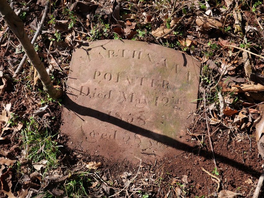
HP-010 Spencer Family Cemetery
Description:
Community: Religious: Family: African American:
Other Site Type:
Number of Burials: Visible Markers: Formal Entrance: Cemetery Sign: Active:
0
Earliest Year: Latest Year: Is the Site Extant?:
0 0 Unknown
Is the Location Sensitive?: Sensitive Contact: Sensitive Reason:
Location Confidence: Location Confirmed:
Approximate No
Volunteer Forms and External Web Links (Montgomery Planning is not responsible for content.
Links provided for informational purposes only)
2006 Survey Summary:
https://mcatlas.org/filetransfer/HistoricPreservation/MCCI_Summaries_2004/MCCI_Summary_ID_010.pdf
Montgomery Preservation, Inc.:
FindaGrave.com:
Maryland Tombstone Transcription Project:
Other Website:
https://mht.maryland.gov/secure/Medusa/PDF/Montgomery/M%3B%2012-42-34.pdfMaster Plan Historic Resource No.: Historic Resource:
Confirmed by Planning Board: Confirmation Date: Site Survey Date: Revision Date:
No 01/12/2022
Site Surveyor Name:
Brian Crane
Data Originator:
Montgomery Preservation, Inc.
Notes:
Maryland Inventory of Historic Places Form 12-42-34. Site visit performed in January 2022 with
long-term neighbor who remembers seeing wooden grave markers. No visible evidence of the
cemetery was found.
Technical information about the locational information shown in the online map.
Public Display Scale: Is there a Restriction on Sharing Information?:
1: 0
GIS Source Date: GIS Source Datum: Boundary Type:
01/12/2022
Horizontal Accuracy: GIS Data Source:
GPS M-NCPPC
Additional Information:
The location mapped by MPI volunteers was substantially off from probable location. The site of the
January 2022 field visit is within the metes and bounds of an 1806 deed (Liber N Folio 33), and
close to where Eugene Scheel mapped it in his map of historical and archaeological sites in Western
Montgomery County.Images: HP-10-01 HP-10-02 1979 photograph showing wooden markers Possible location facing west Date Date 01/12/2022 Photographer Photographer Brian Crane HP-10-03 HP-10-04 Facing Northwest Facing North Date 01/12/2022 Date 01/12/2022 Photographer Brian Crane Photographer Brian Crane
HP-10-05                           HP-10-06
Facing Northeast                   Facing East Southeast

Date           01/12/2022          Date           01/12/2022
Photographer   Brian Crane         Photographer   Brian Crane

 MARKER ID         GIVEN NAME   FAMILY NAME                     DEATH YEAR
Montgomery County Planning Department
The Maryland-National Capital Park and Planning Commission
Montgomery County Burial Sites Inventory
Historic Preservation ID: Name:
HP-172 Merry Go Round Farm "Columbarium"
Description:
Community: Religious: Family: African American:
Other Site Type:
Number of Burials: Visible Markers: Formal Entrance: Cemetery Sign: Active:
2
Earliest Year: Latest Year: Is the Site Extant?:
1969 1992 Unknown
Is the Location Sensitive?: Sensitive Contact: Sensitive Reason:
Location Confidence: Location Confirmed:
Approximate No
Volunteer Forms and External Web Links (Montgomery Planning is not responsible for content.
Links provided for informational purposes only)
2006 Survey Summary:
Montgomery Preservation, Inc.:
https://mcatlas.org/filetransfer/HistoricPreservation/Cemeteries/172_Merry-Go-Round_Potomac/172_Merry-G
o-Round_Potomac_2018/172_Merry-Go-Round_Potomac_2018_Survey.pdf
FindaGrave.com:
Maryland Tombstone Transcription Project:
Other Website:Master Plan Historic Resource No.: Historic Resource:
Confirmed by Planning Board: Confirmation Date: Site Survey Date: Revision Date:
01/24/2018 04/13/2022
Site Surveyor Name:
Glenn Wallace
Data Originator:
Montgomery Preservation, Inc.
Notes:
Burial of Drew and Luvie Pearson near their home. Deed research shows that the location mapped
by MPI is well outside the property they owned. The updated location corrects that error.
Technical information about the locational information shown in the online map.
Public Display Scale: Is there a Restriction on Sharing Information?:
1: 0
GIS Source Date: GIS Source Datum: Boundary Type:
10/15/2018
Horizontal Accuracy: GIS Data Source:
Drew and Luvie Pearson property and house
Additional Information:
Images:
Date
PhotographerMARKER ID GIVEN NAME FAMILY NAME DEATH YEAR
Montgomery County Planning Department
The Maryland-National Capital Park and Planning Commission
Montgomery County Burial Sites Inventory
Historic Preservation ID: Name:
HP-233 Avery Road Cemetery - Smith Family Cemetery
Description:
Community: Religious: Family: African American:
Other Site Type:
Number of Burials: Visible Markers: Formal Entrance: Cemetery Sign: Active:
unknown
Earliest Year: Latest Year: Is the Site Extant?:
Moved
Is the Location Sensitive?: Sensitive Contact: Sensitive Reason:
Location Confidence: Location Confirmed:
Known Yes
Volunteer Forms and External Web Links (Montgomery Planning is not responsible for content.
Links provided for informational purposes only)
2006 Survey Summary:
https://mcatlas.org/filetransfer/HistoricPreservation/MCCI_Summaries_2004/MCCI_Summary_ID_233.pdf
Montgomery Preservation, Inc.:
https://mcatlas.org/filetransfer/HistoricPreservation/Cemeteries/233_Avery-Road_Smith_Rockville/233_Avery
-Road_Smith_Rockville_2018/233_Avery-Road_Smith_Rockville_2018_Survey.pdf
FindaGrave.com:
https://www.findagrave.com/cemetery/2672463
Maryland Tombstone Transcription Project:
Other Website:Master Plan Historic Resource No.: Historic Resource:
Confirmed by Planning Board: Confirmation Date: Site Survey Date: Revision Date:
No 03/25/2018 03/30/2022
Site Surveyor Name:
Julianne Mangin (2018) Brian Crane (2022)
Data Originator:
Montgomery Preservation, Inc.
Notes:
Deed research shows that the location recorded in 2018 is slightly off. Fieldwork in 2022 confirmed
this and found physical evidence of the cemetery, including at least one headstone base, foundation
remains, and multiple large depressions that may be where graves were exhumed and not refilled.
Area of possible graveyard may extend across the hill/stream terrace beyond boundary suggested
by deeds.
Technical information about the locational information shown in the online map.
Public Display Scale: Is there a Restriction on Sharing Information?:
1: 0
GIS Source Date: GIS Source Datum: Boundary Type:
03/30/2022
Horizontal Accuracy: GIS Data Source:
GPS M-NCPPC 2022
Additional Information:
Cemetery boundaries are referenced in a neighboring 1906 deed: "then to exclude the colored
Grave Yard, South seventy three degrees, nine minutes East, eleven and fifteen hundredths
perches; thence North sixteen degrees and fifty one minutes East, three and sixty three hundredths
perches; ; thence North seventy three degrees, nine minutes West, eleven and seventy eight
hundredths perches to the center line of the aforesaid road" (Liber 184 Folio 466-468).
The cemetery is labeled as a "Colored Cemetery" in the 1917 Deets and Maddox "A Real Estate
Atlas of the Part of Montgomery County Adjacent to the District of Columbia" Plate 5.
https://jscholarship.library.jhu.edu/bitstream/handle/1774.2/35333/Plate%2005.JPG?sequence=55&i
sAllowed=yImages: HP-233-01 HP-233-02 Looking north across bridge towards rise Approach to cemetery from trail looking east containing cemetery Date 03/30/2022 Date 03/30/2022 Photographer Brian Crane Photographer Brian Crane HP-233-03 HP-233-04 A shallow depression, possible foundation A shallow depression lined with stones near looking south top of hill facing south Date 03/30/2022 Date 03/30/2022 Photographer Brian Crane Photographer Brian Crane
HP-233-05                              HP-233-06
A shallow depression facing north      Gravestone base near possible foundation
                                       remains

Date           03/30/2022              Date           03/30/2022
Photographer   Brian Crane             Photographer   Brian Crane

HP-233-07
Mortared bricks

Date           03/30/2022
Photographer   Brian Crane

 MARKER ID        GIVEN NAME        FAMILY NAME                     DEATH YEAR
Montgomery County Planning Department
The Maryland-National Capital Park and Planning Commission
Montgomery County Burial Sites Inventory
Historic Preservation ID: Name:
HP-310 Conway-Jackson Cemetery
Description:
Late 19th, early 20th-century African American Cemetery.
Community: Religious: Family: African American:
Other Site Type:
Number of Burials: Visible Markers: Formal Entrance: Cemetery Sign: Active:
100
Earliest Year: Latest Year: Is the Site Extant?:
0 0 Unknown
Is the Location Sensitive?: Sensitive Contact: Sensitive Reason:
Location Confidence: Location Confirmed:
Approximate No
Volunteer Forms and External Web Links (Montgomery Planning is not responsible for content.
Links provided for informational purposes only)
2006 Survey Summary:
https://mcatlas.org/filetransfer/HistoricPreservation/MCCI_Summaries_2004/MCCI_Summary_ID_310.pdf
Montgomery Preservation, Inc.:
FindaGrave.com:
Maryland Tombstone Transcription Project:
Other Website:Master Plan Historic Resource No.: Historic Resource:
Confirmed by Planning Board: Confirmation Date: Site Survey Date: Revision Date:
Yes 05/16/2019 04/13/2022
Site Surveyor Name:
Data Originator:
Montgomery Preservation, Inc.
Notes:
Referenced in Burtonsville Heritage Genealogically Speaking by Audrey Lord (1976). The revision
moves the location suggested by MPI volunteers to be within the property boundary and within the
US 29 right-of-way as described by historical research.
Technical information about the locational information shown in the online map.
Public Display Scale: Is there a Restriction on Sharing Information?:
1: 0
GIS Source Date: GIS Source Datum: Boundary Type:
10/15/2018
Horizontal Accuracy: GIS Data Source:
2006 inventory approx loc
Additional Information:
Audrey Lord reported information she received from Roy Miles for her 1976 book on Burtonsville:
the cemetery was "reported to have been "on the Randy Roby property," in the vicinity of Airy Hill
Road (turn east from Old Columbia pike). However, since no survivors were located when dual
Highway Route 29 came through it was obliterated. Miles recalls 100 to 150 crude stones there, on
roughly an acre of ground, and thought former slaves named Grif Conway and Emma Jackson were
interred there."
Miles' recollection corresponds to an orchard some 250 feet north of a homestead shown on 1950s
aerial photographs and Maryland Highway As-built plans for US 29. The location is on a stream
terrace, and within the ROW for the new Columbia Pike (US 29) alignment.
Emma Jackson was a daughter of Malinda Jackson who purchased the cabin where she and her
family had been enslaved from her former enslaver Ann Downs in 1869. Griffin Conway was a
boarder who lived with the Jacksons on their property. Both the Jackson homestead and the
Conway-Jackson cemetery site are located on land that once belonged to Downs. The nearby
farmstead corresponds to where real estate maps indicate Downs and later owners had their
homes. There are Jackson descendants living in the area today.
Emma Jackson was born in slavery, the daughter of Malinda Jackson who purchased the cabin
where she and her family had been enslaved from her former enslaver Ann Downs in 1869. Griffin
Conway was a boarder who lived with the Jacksons on their property. Both the Jackson homestead
and the Conway-Jackson cemetery site are located on land that once belonged to Ann Downs. The
nearby farmstead corresponds to where real estate maps indicate Downs and later owners had their
homes.Images: HP-310-01 HP-310-02 1951 Aerial photograph and topographic 1954 As-Built plans for US 29 showing map showing probable location of the orchard where cemetery may have been cemetery located Date 04/07/2022 Date 04/07/2022 Photographer Brian Crane Photographer Brian Crane MARKER ID GIVEN NAME FAMILY NAME DEATH YEAR
Montgomery County Planning Department
The Maryland-National Capital Park and Planning Commission
Montgomery County Burial Sites Inventory
Historic Preservation ID: Name:
HP-339 Moneysworth Farm Cemetery
Description:
Small 19th-century family cemetery.
Community: Religious: Family: African American:
Other Site Type:
Number of Burials: Visible Markers: Formal Entrance: Cemetery Sign: Active:
Earliest Year: Latest Year: Is the Site Extant?:
Is the Location Sensitive?: Sensitive Contact: Sensitive Reason:
Location Confidence: Location Confirmed:
Approximate
Volunteer Forms and External Web Links (Montgomery Planning is not responsible for content.
Links provided for informational purposes only)
2006 Survey Summary:
Montgomery Preservation, Inc.:
FindaGrave.com:
Maryland Tombstone Transcription Project:
Other Website:
https://mht.maryland.gov/secure/Medusa/PDF/Montgomery/M%3B%2013-14.pdfMaster Plan Historic Resource No.: Historic Resource:
Confirmed by Planning Board: Confirmation Date: Site Survey Date: Revision Date:
No 01/25/2022
Site Surveyor Name:
Brian Crane
Data Originator:
Notes:
Reserved in a deed from Dorothy Williams to William Willson of John, September 15, 1827 (L BS 1
F 297). Maryland Inventory of Historic Places Form says that Marshall Day testified in 1975 that his
enslaved ancestors were buried near the house. Field visit did not find clear surface evidence of a
cemetery.
Technical information about the locational information shown in the online map.
Public Display Scale: Is there a Restriction on Sharing Information?:
1: 50,000
GIS Source Date: GIS Source Datum: Boundary Type:
Horizontal Accuracy: GIS Data Source:
Additional Information:
This approximate site is estimated to be within a few hundred feet of the historic house, most likely
to the northwest. It is on the grounds of the Moneysworth Farm Master Plan Historic Site 13-14, and
on the grounds of the Montgomery County Correctional Facility.
The MIHP form reads in part: "Marshall Day, a black man, remembers that his relatives worked at
this mill,10 His slave ancestors are buried in a cemetery near the house."Images: HP-339-01 HP-339-02 Historic House from SE Historic House from SW Date 01/25/2022 Date 01/25/2022 Photographer Brian Crane Photographer Brian Crane HP-339-03 HP-339-04 Fieldstones north of house Fieldstone north of house Date 01/25/2022 Date 01/25/2022 Photographer Brian Crane Photographer Brian Crane
HP-339-05                          HP-339-06
Fieldstone northwest of house      Fieldstone west of house

Date           01/25/2022          Date           01/25/2022
Photographer   Brian Crane         Photographer   Brian Crane

 MARKER ID        GIVEN NAME    FAMILY NAME                     DEATH YEAR
Montgomery County Planning Department
The Maryland-National Capital Park and Planning Commission
Montgomery County Burial Sites Inventory
Historic Preservation ID: Name:
HP-340 Convent of the Sisters of Visitation Cemetery
Description:
Cemetery for sisters of the Convent.
Community: Religious: Family: African American:
Other Site Type:
Number of Burials: Visible Markers: Formal Entrance: Cemetery Sign: Active:
23
Earliest Year: Latest Year: Is the Site Extant?:
1920 1982
Is the Location Sensitive?: Sensitive Contact: Sensitive Reason:
Location Confidence: Location Confirmed:
Approximate
Volunteer Forms and External Web Links (Montgomery Planning is not responsible for content.
Links provided for informational purposes only)
2006 Survey Summary:
Montgomery Preservation, Inc.:
FindaGrave.com:
Maryland Tombstone Transcription Project:
Other Website:
https://mht.maryland.gov/secure/Medusa/PDF/Montgomery/M%3B%2035-9-6.pdfMaster Plan Historic Resource No.: Historic Resource:
Confirmed by Planning Board: Confirmation Date: Site Survey Date: Revision Date:
No
Site Surveyor Name:
Data Originator:
Notes:
A 2019 Washington Post article states that 23 graves moved circa 1982 prior to NIH sale. Interment
dates are not known; the date range includes the time the order owned the property.
Technical information about the locational information shown in the online map.
Public Display Scale: Is there a Restriction on Sharing Information?:
1: 50,000
GIS Source Date: GIS Source Datum: Boundary Type:
Horizontal Accuracy: GIS Data Source:
Additional Information:
Review of NIH files by NIH staff did not find materials indicating the original location of the cemetery.
A 1983 survey plat shows the original buildings, but does not indicate a cemetery.
Maryland Inventory of Historic Places Form 35-9-6 reads: "There was a cemetery located at the
Convent. Prior to the sale of the property, the bodies of 23 Sisters were exhumed and re-interred in
other Catholic cemeteries."
Images:
October 1983 Survey Plat of Convent
Date
Photographer NA
HP-340_01MARKER ID GIVEN NAME FAMILY NAME DEATH YEAR
Montgomery County Planning Department
The Maryland-National Capital Park and Planning Commission
Montgomery County Burial Sites Inventory
Historic Preservation ID: Name:
HP-341 Clover Hill Cemetery
Description:
Enslaved persons burial ground in orchard
Community: Religious: Family: African American:
Other Site Type:
Number of Burials: Visible Markers: Formal Entrance: Cemetery Sign: Active:
Earliest Year: Latest Year: Is the Site Extant?:
Is the Location Sensitive?: Sensitive Contact: Sensitive Reason:
Location Confidence: Location Confirmed:
Approximate
Volunteer Forms and External Web Links (Montgomery Planning is not responsible for content.
Links provided for informational purposes only)
2006 Survey Summary:
Montgomery Preservation, Inc.:
FindaGrave.com:
Maryland Tombstone Transcription Project:
Other Website:
https://mht.maryland.gov/secure/Medusa/PDF/Montgomery/M%3B%2023-51.pdfMaster Plan Historic Resource No.: Historic Resource:
Confirmed by Planning Board: Confirmation Date: Site Survey Date: Revision Date:
No
Site Surveyor Name:
Data Originator:
Notes:
Based on information in MIHP Form 23-51 for Clover Hill, a Master Plan Historic Site.
Technical information about the locational information shown in the online map.
Public Display Scale: Is there a Restriction on Sharing Information?:
1: 50,000
GIS Source Date: GIS Source Datum: Boundary Type:
Horizontal Accuracy: GIS Data Source:
Additional Information:
MIHP form reads: "Clover Hill remained in Gaither family hands until 1891, when the heirs of
Thomas Gaither defaulted on the mortgage, and State Senator Henry Benson purchased Clover Hill
at a sheriff's sale. During his ownership, the senator planted an orchard on the property, on the site
of an old slave burial ground. Some of the gravestones which were removed to build the orchard
eventually found their way into a garden wall which adjoins the house, built in 1927, by then-owner
Major J.W. Swaren, U.S. Army."
Images:
South elevation of House
Date 03/07/2004
Photographer Jennifer Cosham (for MHT)
HP-341_01MARKER ID GIVEN NAME FAMILY NAME DEATH YEAR
Montgomery County Planning Department
The Maryland-National Capital Park and Planning Commission
Montgomery County Burial Sites Inventory
Historic Preservation ID: Name:
HP-342 Hilton Farm Cemetery
Description:
Small 19th-century rural family cemetery.
Community: Religious: Family: African American:
Other Site Type:
Number of Burials: Visible Markers: Formal Entrance: Cemetery Sign: Active:
Earliest Year: Latest Year: Is the Site Extant?:
Is the Location Sensitive?: Sensitive Contact: Sensitive Reason:
Location Confidence: Location Confirmed:
Approximate
Volunteer Forms and External Web Links (Montgomery Planning is not responsible for content.
Links provided for informational purposes only)
2006 Survey Summary:
Montgomery Preservation, Inc.:
FindaGrave.com:
Maryland Tombstone Transcription Project:
Other Website:
https://mht.maryland.gov/secure/Medusa/PDF/Montgomery/M%3B%2013-18.pdfMaster Plan Historic Resource No.: Historic Resource:
Confirmed by Planning Board: Confirmation Date: Site Survey Date: Revision Date:
No
Site Surveyor Name:
Data Originator:
Notes:
An 1868 deed reserves 1/4 acre for a burial ground.
Technical information about the locational information shown in the online map.
Public Display Scale: Is there a Restriction on Sharing Information?:
1: 50,000
GIS Source Date: GIS Source Datum: Boundary Type:
Horizontal Accuracy: GIS Data Source:
Additional Information:
The Maryland Inventory of Historic Places Form 13-18 reads: "In 1868, after Margaret Purdum's
remarriage, the property was ordered sold under a court order, with the proceeds to be divided
among Purdum's eight children. Thomas Anderson was appointed trustee for the sale of Purdum's
property, described as "200-250 acres, with a comfortable dwelling, a barn, and two tobacco houses
worth $20 an acre " The property was divided into three lots and lot #1, containing 124 acres (part of
two tracts known as "The Resurvey of Locust Levels" and "The Addition to Brooks Grove") was sold
to George W. and Frances C. Hilton for $35.50 an acre, one quarter acre was reserved for a
graveyard. The dower lot, which was reserved for Purdum's widow, contained 36 112 acres and a
one-bay, two-story, gable-roof dwelling."
Images:
1951 Aerial with 1868 farm boundary shown
in red, possible cem loction shown as green
triangle
Date 04/06/2022
Photographer Brian Crane
HP-342-01MARKER ID GIVEN NAME FAMILY NAME DEATH YEAR
Montgomery County Planning Department
The Maryland-National Capital Park and Planning Commission
Montgomery County Burial Sites Inventory
Historic Preservation ID: Name:
HP-343 Samuel O. Jones House Cemetery
Description:
Small 19th-century rural family graveyard.
Community: Religious: Family: African American:
Other Site Type:
Number of Burials: Visible Markers: Formal Entrance: Cemetery Sign: Active:
Earliest Year: Latest Year: Is the Site Extant?:
1847
Is the Location Sensitive?: Sensitive Contact: Sensitive Reason:
Location Confidence: Location Confirmed:
Approximate
Volunteer Forms and External Web Links (Montgomery Planning is not responsible for content.
Links provided for informational purposes only)
2006 Survey Summary:
Montgomery Preservation, Inc.:
FindaGrave.com:
Maryland Tombstone Transcription Project:
Other Website:
https://mht.maryland.gov/secure/Medusa/PDF/Montgomery/M%3B%2014-61.pdfMaster Plan Historic Resource No.: Historic Resource:
Confirmed by Planning Board: Confirmation Date: Site Survey Date: Revision Date:
No
Site Surveyor Name:
Data Originator:
Notes:
Referenced on MIHP Form 14-61.
Technical information about the locational information shown in the online map.
Public Display Scale: Is there a Restriction on Sharing Information?:
1: 0
GIS Source Date: GIS Source Datum: Boundary Type:
Horizontal Accuracy: GIS Data Source:
Additional Information:
The Maryland Inventory of Historic Places Form (14-61) prepared in 1979 reads: "The family
graveyard dates from 1847 and remains on the property, enclosed by a brick wall."
Images:
HP-343_01
SW Corner Historic House
Date 08/23/1974
Photographer Mike DwyerMARKER ID GIVEN NAME FAMILY NAME DEATH YEAR
Montgomery County Planning Department
The Maryland-National Capital Park and Planning Commission
Montgomery County Burial Sites Inventory
Historic Preservation ID: Name:
HP-344 John A. Jones Farm Cemetery
Description:
Small 19th-century rural family graveyard.
Community: Religious: Family: African American:
Other Site Type:
Number of Burials: Visible Markers: Formal Entrance: Cemetery Sign: Active:
Earliest Year: Latest Year: Is the Site Extant?:
Is the Location Sensitive?: Sensitive Contact: Sensitive Reason:
Location Confidence: Location Confirmed:
Approximate
Volunteer Forms and External Web Links (Montgomery Planning is not responsible for content.
Links provided for informational purposes only)
2006 Survey Summary:
Montgomery Preservation, Inc.:
FindaGrave.com:
Maryland Tombstone Transcription Project:
Other Website:
https://mht.maryland.gov/secure/Medusa/PDF/Montgomery/M%3B%2016-3.pdfMaster Plan Historic Resource No.: Historic Resource:
Confirmed by Planning Board: Confirmation Date: Site Survey Date: Revision Date:
No 02/09/2022
Site Surveyor Name:
Data Originator:
Notes:
Referenced on MIHP Form 16-3. A field visit on February 9, 2022 did not identify any surface
evidence for the cemetery. The site is a Locational Atlas Historic Site, and owned by Montgomery
County.
Technical information about the locational information shown in the online map.
Public Display Scale: Is there a Restriction on Sharing Information?:
1: 0
GIS Source Date: GIS Source Datum: Boundary Type:
Horizontal Accuracy: GIS Data Source:
Additional Information:
The Maryland Inventory of Historic Places Form (16-3) reads: "At the time of his death (circa 1807}
Thomas Cooley (Cowley) willed his plantation to his wife and seven children. His widow continued to
occupy the house until her death in 1825. Her will mentioned a family graveyard on the property."
The will reads: "after my debts and funeral charges are paid, and the expence [sic.] of walling the
grave yard in with stone and pointed with lime on the insides and out are paid"Images: HP-344-01 HP-344-02 Entrance to farm facing east Farmstead Date 02/09/2022 Date 02/09/2022 Photographer Brian Crane Photographer Brian Crane MARKER ID GIVEN NAME FAMILY NAME DEATH YEAR
Montgomery County Planning Department
The Maryland-National Capital Park and Planning Commission
Montgomery County Burial Sites Inventory
Historic Preservation ID: Name:
HP-346 Belt Farm Cemetery
Description:
Small 19th-century rural family cemetery.
Community: Religious: Family: African American:
Other Site Type:
Number of Burials: Visible Markers: Formal Entrance: Cemetery Sign: Active:
Earliest Year: Latest Year: Is the Site Extant?:
1888 1889
Is the Location Sensitive?: Sensitive Contact: Sensitive Reason:
Location Confidence: Location Confirmed:
Approximate
Volunteer Forms and External Web Links (Montgomery Planning is not responsible for content.
Links provided for informational purposes only)
2006 Survey Summary:
Montgomery Preservation, Inc.:
FindaGrave.com:
https://www.findagrave.com/memorial/129402189/john-benjamin-belt
Maryland Tombstone Transcription Project:
Other Website:
https://mht.maryland.gov/secure/Medusa/PDF/Montgomery/M%3B%2022-26.pdfMaster Plan Historic Resource No.: Historic Resource:
Confirmed by Planning Board: Confirmation Date: Site Survey Date: Revision Date:
No
Site Surveyor Name:
Data Originator:
Notes:
Recorded by Michael Dwyer, M-NCPPC Park Historian 8/19/75.
Technical information about the locational information shown in the online map.
Public Display Scale: Is there a Restriction on Sharing Information?:
1: 0
GIS Source Date: GIS Source Datum: Boundary Type:
Horizontal Accuracy: GIS Data Source:
Additional Information:
MIHP Form 22-26 reads: "The old family graveyard is located in the center of the field, to the NE of
the buildings. The base of a marker remains, but the bodies were reinterred at Rockville Cemetery.
Two of the stones are in the yard of Mrs. Ruth (Belt) Pope, nearby. They read:
In memory of our father
John Belt
Passed to rest Nov. (?)
Aged (?) 2 mos.
I have. fought a .good fight
I have finished my course
I have kept the faith
Nancy
wife of
John Belt
Born Sept. 14, 1810
Died March 14, 1888"Images: HP-346-01 1951 Aerial photograph of approximate area where original grave locations were noted in 1975 by Parks historian Mike Dwyer Date 04/08/2022 Photographer Brian Crane MARKER ID GIVEN NAME FAMILY NAME DEATH YEAR
Montgomery County Planning Department
The Maryland-National Capital Park and Planning Commission
Montgomery County Burial Sites Inventory
Historic Preservation ID: Name:
HP-347 Brown Farm Cemetery
Description:
Small 19th-century rural family cemetery.
Community: Religious: Family: African American:
Other Site Type:
Number of Burials: Visible Markers: Formal Entrance: Cemetery Sign: Active:
Earliest Year: Latest Year: Is the Site Extant?:
Is the Location Sensitive?: Sensitive Contact: Sensitive Reason:
Location Confidence: Location Confirmed:
Known Yes
Volunteer Forms and External Web Links (Montgomery Planning is not responsible for content.
Links provided for informational purposes only)
2006 Survey Summary:
Montgomery Preservation, Inc.:
FindaGrave.com:
Maryland Tombstone Transcription Project:
Other Website:
https://mht.maryland.gov/secure/Medusa/PDF/Montgomery/M%3B%2023-155.pdfMaster Plan Historic Resource No.: Historic Resource:
Confirmed by Planning Board: Confirmation Date: Site Survey Date: Revision Date:
No 02/02/2022
Site Surveyor Name:
Brian Crane
Data Originator:
Notes:
Mentioned on Maryland Inventory of Historic Places Form 23-155 recorded in 2008.
Technical information about the locational information shown in the online map.
Public Display Scale: Is there a Restriction on Sharing Information?:
1: 0
GIS Source Date: GIS Source Datum: Boundary Type:
Horizontal Accuracy: GIS Data Source:
Additional Information:
There are several upright fieldstones on the edge of the hill to the east of the farmhouse ruins noted
by archaeologists in 2007. At least two potential uninscribed fieldstone grave markers were noted in
a heavily overgrown area during a site visit in February 2022.Images: HP-347-02 HP-347-03 Approach to Cemetery Uninscribed Marker Date 02/02/2022 Date 02/02/2022 Photographer Brian Crane Photographer Brian Crane HP-347-04 Uninscribed Marker Date 02/02/2022 Photographer Brian Crane MARKER ID GIVEN NAME FAMILY NAME DEATH YEAR
Montgomery County Planning Department
The Maryland-National Capital Park and Planning Commission
Montgomery County Burial Sites Inventory
Historic Preservation ID: Name:
HP-348 Harrison Island Civil War Burials
Description:
Civil War burials associated with the Battle of Balls Bluff.
Community: Religious: Family: African American:
Other Site Type:
Civil War battlefield burials
Number of Burials: Visible Markers: Formal Entrance: Cemetery Sign: Active:
unknown
Earliest Year: Latest Year: Is the Site Extant?:
1861 1861
Is the Location Sensitive?: Sensitive Contact: Sensitive Reason:
Location Confidence: Location Confirmed:
Approximate
Volunteer Forms and External Web Links (Montgomery Planning is not responsible for content.
Links provided for informational purposes only)
2006 Survey Summary:
Montgomery Preservation, Inc.:
FindaGrave.com:
Maryland Tombstone Transcription Project:
Other Website:
https://mht.maryland.gov/secure/Medusa/PDF/Montgomery/M%3B%2016-32.pdfMaster Plan Historic Resource No.: Historic Resource:
Confirmed by Planning Board: Confirmation Date: Site Survey Date: Revision Date:
Site Surveyor Name:
Data Originator:
Notes:
The farmhouse on the island was used as a field hospital during the Battle of Balls Bluff in October
1861. Multiple contemporary accounts mention Union casualties buried on the island.
Technical information about the locational information shown in the online map.
Public Display Scale: Is there a Restriction on Sharing Information?:
1: 0
GIS Source Date: GIS Source Datum: Boundary Type:
Horizontal Accuracy: GIS Data Source:Additional Information: “The dead and wounded were collected in an old house on Harrison’s Island, and were ferried across to the Maryland shore as rapidly as possible during the night, and were then put on canal-boats and taken down to Edwards Ferry, where the wounded were sent to their different regimental hospitals, while the dead were laid on stretchers and on shutters and doors taken from the house on the island, and placed in a row on the porch of the old store near the ferry.” 20th Massachusetts pg 61-62. “I reported with the men at the hospital on the island.” Patch 1958: 42 “The detachment of the Tammany regiment that remained on the island in consequence of the accident heretofore mentioned —consisting of Companies B, Lieut. James McGrath commanding ; D, Capt. Isaac Gotthold, commanding; F, Capt. J. W. Tobin, commanding; G, Capt. John Quinn commanding; and I, Capt. David Hogg commanding — were on active and arduous service from the moment of their arrival on the island until 2 pm. Of the succeeding day in taking care of and conveying the wounded to the hospital, and in standing in the intrenchments as a guard under a heavy and incessant fire from the enemy.” Patch 1958:49. “Meanwhile others of us were removing the wounded and burying the dead on the island. I was told off as one of the burying party. For any boy of seventeen it would have been a trying task. It was so for me who had rarely seen a corpse and never one from violence. Sunk in the mud, or sprawling on wet grass, the naked or half-clad bodies were fearful in their pallor, grimy with dirt and horrible with gaping wounds. Some features were placid and peaceful as though death was welcome, while others were twisted and contorted as if unbearable pain had come at the end, but all were ghastly in my eyes. A sense of duty and the wish to care duly for the bodies of our slain comrades kept me up to the work without murmur or any sense of repulsion. It was a serious training in the art of war, which made a deep impress on my future life. Near our trenches was the body of a man, naked save for his trousers, who had been shot through the forehead as he came out of the river, after swimming across. Covered with mud and slime, blood oozing out of the wound, he lay on the river bank, head up and mouth open. As he was taken up for burial, one of the men said that he opened his lips, and so must be alive. A heartless man said, “Take him along with the others. He'll never get well.” Mahoney cried out, “You d. .. . . brute, I’d like to kill you! You must bury me before him.” The unconscious man was carried back to the Maryland shore and sent to the hospital, where I was later told he fully recovered. I shuddered to think how near we had come to burying a man alive.” Greely 1927: 40-41. “Forty-seven bodies were buried upon the battle-field, twelve were brought over to Harrison’s Island, and almost twenty were left for the enemy to bury.” Story of the Fifteenth pg 95. “When I got upon the island they commenced with him, and while they were extracting the bullets from his thigh, he said: ' Chaplain, will you find my wallet and put those bullets in? I shall want them some time.' From that time throughout he has been bright, cheerful and hopeful.” Story of the Fifteenth pg 104. “October 17, Lieutenant Derby writes: “ We are fortifying the island and are to have reënforcements and hold it in case of attack . I was up till three o'clock this morning overseeing the throwing up of intrenchments. The ruins of the old stone barn make a good fort."” Story of the Fifteenth pg 60. “Arriving at the island, we found that the firing we had heard was no boys' play. Quite a number of Company H's men lay wounded in the only house there was. It was then and there that we first witnessed the horrors of war. Leaving our blankets and overcoats in the ruins of an old barn, we embarked, or rather my company crowded itself on to the only boat there was for conveying us to the Virginia shore.” Story of the Fifteenth pg 77.
“As it became dark, the wounded were crowded together in and about the two farm houses, which
were used as hospitals. “No light had been provided or could be found until Surgeon Haven
discovered two inches of candle in an old bottle, by the light of which Lieutenant-Colonel Ward’s
limb was amputated.” “It was a sad sight to see a brave officer in that position.” More candles were
afterwards found in a closet. Surgeon Bates, who rose for this work from a sick bed to which he had
been confined for several weeks, attended to the wounded on the Maryland shore. Surgeon
Haywood of the Twentieth Massachusetts was with Assistant-Surgeon Haven on the island.
Chaplain Scandlin was also very devoted in his attentions to the wounded and dying. The
transportation of the wounded to the Maryland shore was continued until the noon of Tuesday,
October 22.” Story of the Fifteenth pg 93-94.

“We struck a barn-yard. Long ricks of straw and hay were on our right, under which men, horses,
cannon, and provisions were crowded for shelter, and as we got on a little farther, an extraordinarily
high hedge, around a queer barn, commenced in grand style of hewn stone but never completed,
being a central octagon of fifty feet diameter, and two wings, one from the south face and one from
the east, and full of soldiers eating raw pork and hard bread, and belonging to Hincks's regiment
(Nineteenth Massachusetts).
Hamilton, William R. "Ball's Bluff: From the Diary of the Late Major L.H.D. Crane, Third Wisconsin
Volunteers," The United Service. A Monthly Review of Military and Naval Affairs, n.s. vol. 17
(January 1897). Pg 15

The farm - house had been used by the surgeons, and the larger room upon the lower floor I found
completely covered with blood, and in one corner, feet, hands, and arms were piled like pig's feet in
a butcher's shop, while in an old shabby building adjoining (the inevitable “ old house ” which the
people here never tear down or burn up but leave to use for a wood-shed, or granary, or to
bacco-house, or nigger-quarters, until it passes fitness for any earthly use and then suffer it to lie
and rot in its place) lay the bodies of the men who had been operated on and died on the island. Out
in the rain, close by were also several dead bodies, and all —ex necessitate—naked. The men were
digging a trench to bury them in one corner of the yard, under a large chestnut tree, as we came
away.
Hamilton, William R. "Ball's Bluff: From the Diary of the Late Major L.H.D. Crane, Third Wisconsin
Volunteers," The United Service. A Monthly Review of Military and Naval Affairs, n.s. vol. 17
(January 1897). Pg 16

NB: a building shape matching the barn description above is on an 1865 map.

Images:
                                                      Civll War Era Map of Harrison's Island,
                                                      approximate location of possible burials
                                                      shown as a green triangle
                                                      Date           04/08/2022
                                                      Photographer   Brian Crane

HP-348-01
You can also read