CADASTRE IN
    REPUBLIC OF BULGARIA
A GUARANTEE FOR THE RIGHT OF
   OWNERSHIP OF IMMOVABLE
         PROPERTIES
←
→
Page content transcription
If your browser does not render page correctly, please read the page content below
CADASTRE IN
REPUBLIC OF BULGARIA
A GUARANTEE FOR THE RIGHT OF
OWNERSHIP OF IMMOVABLE
PROPERTIES
Cadastre in Bulgaria for almost 100 years
¾   Cadastre Act (published SG,
    issue 8 of 1908 )
    Main objective:
    - physical and legal determination
    of immovable properties;
    - introduction of land books
    - fair land taxation.
¾   Cadastre and Land
    Consolidation Act (published
    SG, issue 127, of 1941)
    Art.1. ”Cadastre is geometric
    representation, entry in a register
    and description of the immovable
    properties”.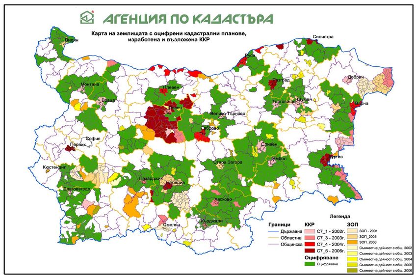
¾   Law on the Unified Cadastre of
    Peoples Republic of Bulgaria
    (published SG, issue 35/1979)
    - clear routine for production,
     announcement and approval of
     cadastral plans;
    - essential drawback – requires
     collection of all data for the
     territory of the country including
     the natural resources, surface and
     underground valuables.
¾    Cadastre and Property Register
    Act (published SG, issue
    34/2000)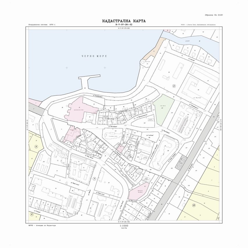
130 years of geodetic and cadastral activities
                    in Bulgaria
¾   1877 – first topographic map in scale
    1:42000
¾   1919 – Geographic Institute was found
    (an independent surveying and
    cartographic office)
¾   1920 - 1942 - The Geographic Institute
    sets up a continuous network of 107
    triangulation points of Іst order
¾   1920 - 1926 – first measurement of the
    State Leveling Network – Іst order,
    length – 5 500 km with 4 500
    benchmarks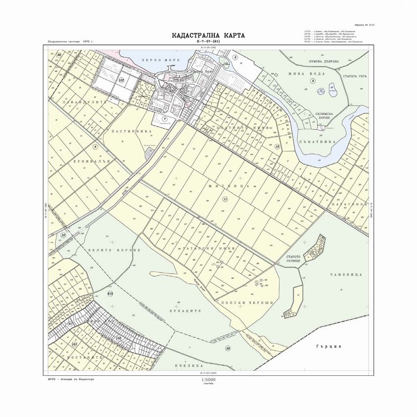
¾   1932 - 1952 – topographic map
    of Bulgaria in scale 1:25000
¾   1985 – the whole territory of the
    country is covered by a large scale
    topographic map in scales 1:5000
    and 1:10000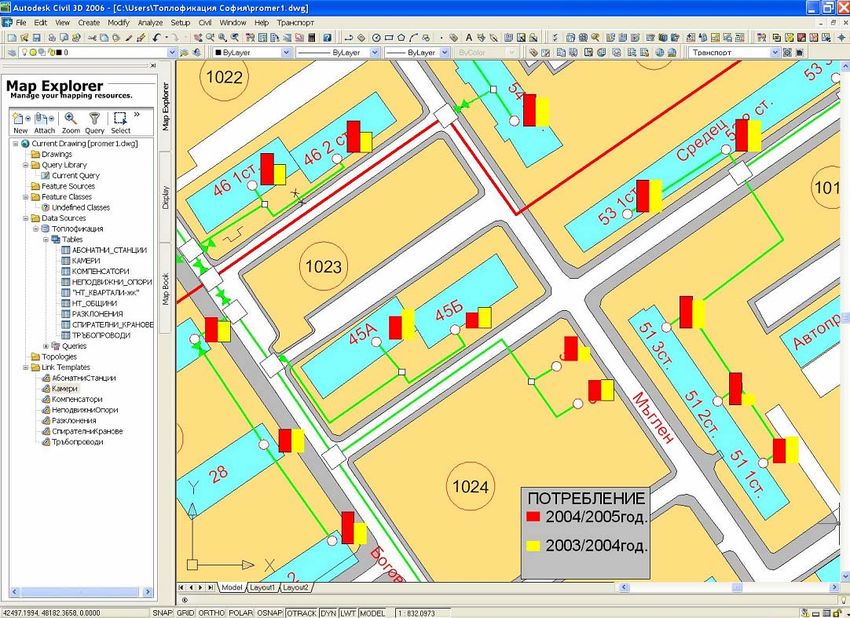
Authorities, responsible for cadastre and land
              ownership before the CPRA
¾   Main department “Geodesy, cartography and cadastre”
    - cadastral plans of urban areas
¾   Ministry of regional Development and Public Works
    - cadastral plans of urban areas and geodetic activities
    - acts of exclusive state ownership
¾   Municipal Offices Agriculture and Forests
    - map of restored ownership
    - decisions on restoration of ownership in agricultural land and forests.
¾   Municipal Authorities
    - data from cadastral plans of urban territories
    - acts of municipal ownership.
¾   Regional Authorities
    - acts of state ownership.
¾   Notaries ( private since 1997)
    - performing required by law notarial activities.
¾   Regional Courts
    - entry of acts, related to real rights.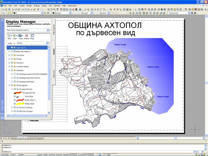
Cadastral concept

¾   Process of creation, maintenance, keeping and provision of information
    about immovable properties for territory of the whole country
¾   Main basis for successful land management
¾   Reliable source of information for taxation purposes
¾   A basis for collection, processing and use of additional data about
    immovable properties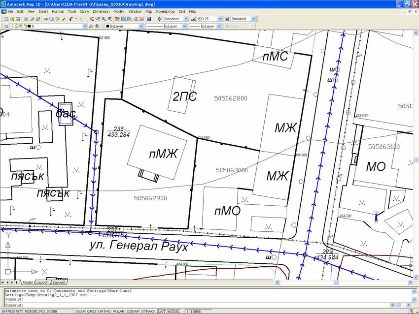
Reforms in the field of cadastre in Bulgaria

¾   Legal reform:
    Restitution and privatization of immovable properties required amendment
    of cadastre related legislation
    - Cadastre and Property Register Act – 2000
    - Geodesy and Cartography Act– 2006
¾   Institutional reform:
    - Cadastre Agency – 2000
    - Registry Agency – 2004
    Cadastre Agency becomes the single institution serving the users with
    cadastral information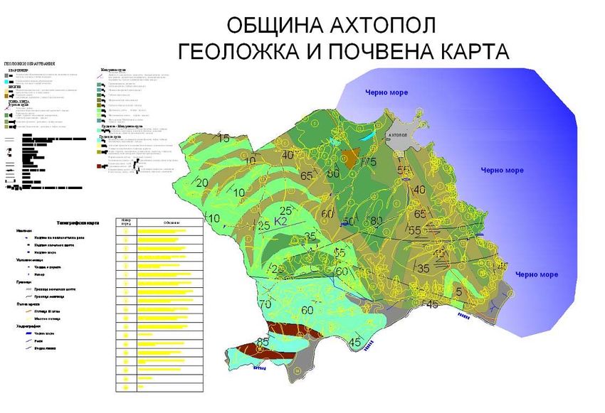
The reform in the field of cadastre –
               a guarantee for:

¾   The right of ownership
¾   Secure transactions and mortgages
¾   Limitation of court disputes
¾   Fair taxation policies
¾   Development of the immovable properties market
¾   More efficient investments
General principles in the new Cadastre and
                  Property Register Act

  CPRA - passed in 2000, effective since 01.01.2001
¾ General principles:
  - cadastre shall cover the territory of the whole country – including
  settlements, agricultural land, forests and other territories ;
  - providing data about the land properties, buildings and the self – contained
  objects in buildings (apartments, studious, shops, garages, recreation and
  health centres etc.);
  - each immovable property shall be given unique number (identifier);
  - The Geodesy Cartography and Cadastre Agency is the single authority,
  issuing sketches of immovable properties in case of change of the right of
  ownership and establishment of other real right;
  - From personal to property based system of registration;
  - Cadastre is basis for setting up of geographic information systems.
Geodesy, Cartography and Cadastre Agency 1618 София, 1 Musala Str. tel. +359 2 8188383, fax +359 2 9555333, e-mail : acad@cadastre.bg, www.cadastre.bg ¾ Collecting and maintenance of cadastral information for the whole territory of Bulgaria ¾ Organization, financing and control of activities in the field of geodesy and cartography ¾ Control for compliance with the legal framework ¾ Provision of services to the public
¾   Maintenance of the state geodetic, cartographic and cadastral fund
    (Geocardfund)
¾   Keeping the registers of licensed surveyor

      The Agency fulfils its role through its 28 regional units – Geodesy,
                       Cartography and Cadastre Offices.
Archives
Main responsibilities of the Geodesy, Cartography
       and Cadastre Agency according to CPRA:

¾     Creation and maintenance of cadastral map and cadastral registers for the
      whole territory of the country
¾     drafting acts and regulations in the field of cadastre and geodesy, as well
      as programs and concepts on future development
¾     implementation of cadastral activities in close coordination with these of
      the property register, UCATTU (Unified Classification of
      Administrative-Territorial and Territorial Units), BULSTAT (Unified
      Classification of identification of juridical persons), ESGRAON (Unified
      System for identification of physical persons), registers of state and
      municipal properties
¾     administrative and technical servicing the public, state administration,
      municipalities and other users of cadastral information
¾     maintenance of the state geodetic, cartographic and cadastral fund
¾     maintenance of register of physical and juridical persons, licensed to
      carry out activities in the filed of cadastre, geodesy and cartography
Main responsibilities of the Geodesy, Cartography
and Cadastre Agency according to GCA:
¾ creation and maintenance of topographic maps in scales 1:5000 and 1:10 000
for the territory of the country
¾ maintenance of the state leveling network and the mareographic stations
network
¾ creation and maintenance of topographic databases and the geographic
information system
¾ implementation of technical activities related to establishment of the
geographic names in the Republic of Bulgaria, keeping a register of names,
creation and maintenance of databases and information system
¾ cooperation with the state administration, and other organizations in the
country and abroadState GPS network
Contents of cadastre
¾ Location, boundaries and area of immovable properties – landed properties,
buildings and self contained objects in buildings (apartments, shops, garages,
studious etc.)
¾ Data about the owners
¾ Data about the acts, which are grounds for the ownership rights
¾ Data about other real rights in immovable properties.
¾ Data about the immovable properties, owners and acts are reflected in:
- the cadastral map;
- cadastral register of immovable properties.
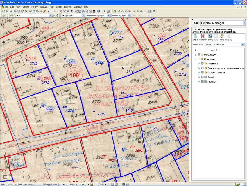
¾ Information is kept and maintained in digital, graphical and written formatsCadastral map
Immovable property according to CPRA

Immovable property – cadastral
object is:
- landed property (basic cadastral
unit);
- building;
- self contained object in building
(apartment).
Basic cadastral data

¾   For the landed properties – identifier; boundaries fixed by the geodetic co-
    ordinates of the points defining them; area; durable land use; land use
    mode; address
¾   For the buildings – identifier, built up area, number of floors, destination
¾   For the self contained objects in buildings - identifier; location; floor
    number, use
Sources of information for production of
cadastral map and registers
¾ The cadastral map is produced on the basis of information from:
- cadastral plans (LUCPRB and LTRD);
- regulation plans (LTRD and PPA);
- map of restored ownership (OUALA and ROFFFLA);
- geodetic, photogrammetric and other surveys.
¾ The cadastral registers are produced on the basis of information from:
- registers to plans and maps;
- acts submitted by municipalities, regional authorities and individual
citizens;
Data about the ownership right and other real rights are coordinated with
these from the entry offices.Cadastral map of territory, belonging to the village
of Ignatovtsi, Gabrovo RegionThe cadastre is requisite for:
¾ Guaranteeing the ownership right
¾ Secure transactions
¾ Secure mortgaging
¾ Resolving disputes about property boundaries
¾ Fair taxation policy
¾ Regional development – land reform, land consolidation,
regulation of territories, forestry management, design of
infrastructure
¾ Determination of market values for compensation
¾ Insurance
¾ Statistical analyses etc.Cadastre and Property Register Information System
Computerized Information Systems shall be developed for the cadastre and the
property register. The systems shall interlinked.
¾ Dispersed Databases, located at:
- Geodesy, Cartography and Cadastre Offices – source of information about location
and boundaries of properties;
- Entry Offices – source of information about owners and ownership rights.
¾ The bidirectional connection between the two databases is based on immovable
property identifier
¾ The information system is linked to the other registers - UCATTU, BULSTAT,
ESGRAON, registers of state and municipal properties etc.
¾ The information system provides constant and direct access to data from the
cadastral map through Internet. It is secured against unauthorized accessCadastre and Property Register Information
System
¾ The Integrated Cadastre and Property Register Information has three
components:
- cadastral component – set up for the Geodesy Cartography and Cadastre
Agency needs, which supports the processes for creation and maintenance
of cadastral map and cadastral registers data;
- property registration component – set up for the Registry Agency needs
and supporting the creation and maintenance of property register data
processes;
- web portal – providing users with access for search and use of data from
both cadastre and property register.Users of the Cadastre and Property Register
Information System
¾ State Authorities
¾ Regional Authorities
¾ Municipal Authorities
¾ Notaries
¾ Regional offices ‘Agriculture and Forests’
¾ Municipal offices ‘Agriculture and Forests’
¾ Private geodetic companies
¾ Banks
¾ Real estate agents
¾ Investors
¾ othersEuropean level of quality of provided services
¾ One-stop-shop
¾ Internet data access
¾ Easy access for handicapped
persons
¾ Transparency of operationsServicing the Cadastral Information System
clients
Realized through:
¾ 28 Geodesy, Cartography and Cadastre Offices, located in regional centers and
¾ 15 structural units of Geodesy, Cartography and Cadastre Offices – located in
municipal centers.
Geodesy, Cartography and Cadastre Agency provides generalized information
about more than one region or the whole country.
Cadastre is public. Access to data shall comply with the provisions under the
Classified Information Act and Personal Data Protection Act.Cadastral information about landed property
Cadastral information about landed property
               and ownership
Cadastral information about building
Cadastral information about building and
               ownership
Cadastral information about self contained
object in building (apartment)Cadastral information about self contained object in
building (apartment) and ownershipIssuance of a sketch
Chart of self contained object in building
Production of cadastral map and cadastral
               registers is based on:

¾   Long Term Program for creation of cadastre and property register, passed by
    CM Decision 326 of 2001

¾   Priorities:
    - regional centers;
    - municipal centers;
    - territories with active market (Black Sea coast, mountainous and sea resorts,
    border zones).
Cadastre and Property Registration Project –
co-financed with the World Bank
¾ Partners:
- Geodesy Cartography and Cadastre Agency
- Registry Agency
¾ Goals:
- Production of new cadastral map and
cadastral registers in digital format;
- Production of property register in digital
format;
- Development of Cadastre and Property
Register Information Systems;
- Equipment for the Geodesy Cartography
and Cadastre Agency;
- Equipment for the Registry Agency.State of the art and perspectives for production
of cadastre in Bulgaria
By 31 January 2007:
¾ CMCR – approved or in process of production - for 27 regional centers, 56
municipal centers and another 400 settlements
¾ 1 400 settlements, which is 32% of the territory of the country, have digitized
cadastral plans
By the end of 2007:
¾ CMCR will be produced for about 20% от of the territory of the country, which
will cover approximately 3 000 000 immovable properties
By the end of 2010:
¾ Cadastral information about 70% of the immovable properties in the country
will be availableWhat can be used the data for ¾ Information from cadastral map and registers: - for creation of key registers of immovable properties and owners in Bulgaria; - for control of tax declarations (alternative for the way of capturing information for tax registers); - as basis for various thematic maps. ¾ Information from the large scale topographic map: - land administration; - infrastructure projects; - navigation etc. ¾ Geographic information: - for GIS based applications; - national geographic data exchange standard.
Cadastre and operation of municipalities

¾   Cadastre is a basis for:
    - regional development plans;
    - investment projects;
    - physical planning maps;
    - thematic maps.
¾   Role of cadastre in the regional and municipal authorities operation:
    - development strategies;
    - maintenance of state and municipal ownership registers;
    - facilitation of state and municipal ownership management;
    - environment protection;
    - management of protected areas, territories of water sources, protected
    coast lines;
    - information for disaster recovery and repair works.
Thematic maps
Combined information from cadastre and
     urban development planning
Combined information from cadastre and
physical planningThank you for your attention
You can also read