California Wildfires 12.11.18 Update - HUB International
←
→
Page content transcription
If your browser does not render page correctly, please read the page content below
California Wildfires 12.11.18 Update

                                                                                                                                                                     Risk Services Division
                                                                                                                                                                           12 November 2018
Legal Notice

All consulting services performed by HUB are advisory in nature. All resultant reports are based upon conditions and practices observed by HUB and information supplied by the client. Any such reports
may not identify or contemplate all unsafe conditions and practices; others may exist. HUB does not imply, guarantee or warrant the safety of any of the client’s properties or operations or that the client or
any such properties or operations are in compliance with all federal, state or local laws, codes, statutes, ordinances, standards or recommendations. All decisions in connection with the implementation, if
any, of any of HUB’s advice or recommendations shall be the sole responsibility of, and made by, the client.The advice and recommendations submitted in this plan constitute neither a warranty of future
results nor an assurance against risk. This material represents the best judgment of HUB and is based on information obtained from both open and closed sources.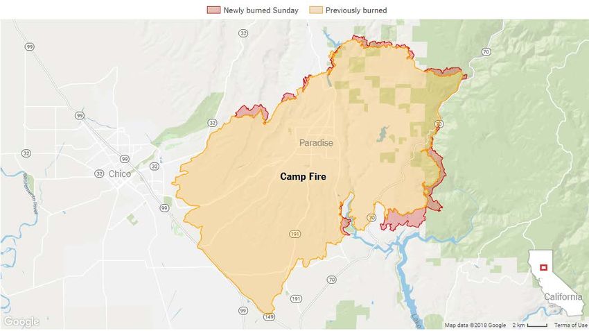
HUB Risk Services Sensitive 12 November 2018
California Wildfires For Official Use Only 07:00 AM PT
California Wildfires
Status at (07:00 AM PT) 12 November, 2018
State of Emergency declared for Los Angeles and Ventura Counties
State of Emeregency declared for Butte County
At least 31 fatalities reported
Over 250,000 people displaced
Currently thirteen active fires across the state
The three fires of greatest concern remain the Camp, Woolsey, and Hill fires
Fire Weather Warnings (Red Flag) are issued in northern, central, and
southern regions of the state
Strong offshore winds continue to produce dangerous fire weather threats:
extreme fire conditions persist in southern California and elevated fire
conditions exixt in northern California
Sensitive
Page 2 of 12
For Official Use Only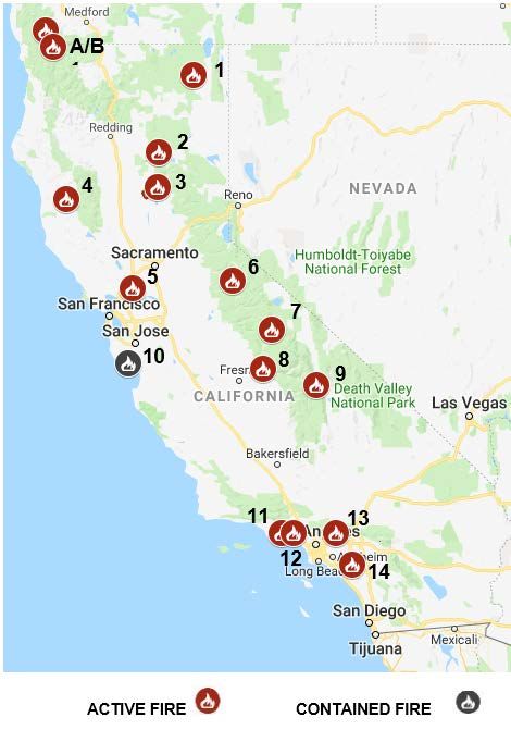
HUB Risk Services                                                            Sensitive                                                   12 November 2018
California Wildfires                                                    For Official Use Only                                                 07:00 AM PT

 Summary

 As of 07:00 PT (1500 UTC), thirteen fires are active across the state of California. The three fires of greatest concern continue to be the Camp, Woolsey, and Hill
 fires.

 Camp Fire

 Twenty-nine fatalities associated with the Camp fire
 are reported. The fire is burning near Chico,
 approximately 90 miles north of Sacramento. The fire
 has burned 113,000 acres and is 25% contained.
 Approximately 15,500 structures are threatened, 6,453
 residential and 260 commercial structures have been
 destroyed. More than 4555 fire personnel are working
 the fire. Evacuation orders are established for
 Paradise, Magalia, Concow, Butte Creek Canyon, and
 Butte Valley.

 Strong northeast winds are expected to continue
 through Monday morning. Firefighters worked through
 the night to hold perimeter lines and provide structure
 defense in areas where the fire was impacting
 structures. Steep rugged terrain in some areas will
 impede control operations. Today firefighters will
 continue to fight the fire aggressively, provide structure
 defense and strategically be pre-positioned in the case
 of any wind shifts.

                                                                             Sensitive
                                                                                                                                              Page 3 of 12
                                                                        For Official Use Only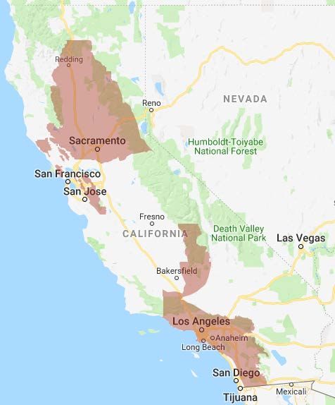
HUB Risk Services Sensitive 12 November 2018
California Wildfires For Official Use Only 07:00 AM PT
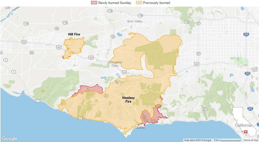
Woolsey Fire
Two fatalities associated with the Woolsey fire have
been reported. The fire is burning in a densely
populated area and currently threatens the
communities of Thousand Oaks, Oak Park, Westlake
Village, Agoura Hills, West Hills, Simi Valley,
Chatsworth, Bell Canyon, Hidden Hills, Malibu and
Calabasas.
The fire has burned 91,572 acres and is 20%
contained. At least 57,000 structures are threatened
and an estimated 370 have been destroyed.
Currently 3227 personnel are fighting the fire. Due to
extreme fire behavior, firefighting efforts have been
focused, and will remain focused, on the protection of
life, and structures. Favorable overnight weather
conditions contributed to minimal fire growth, which
allowed crews to reinforce containment lines. Crews
will continue to be challenged with steep terrain,
limited access, and extreme fire behavior. Moderate
to strong Santa Ana winds will continue across the
area throughout the evening and peak into tomorrow
morning.
Hill Fire
The Hill fire is burning in Ventura County. The fire is 4,531 acres and 75% contained. Two structures are reported destroyed. No fatalities are reported. Due to
extreme fire behavior, firefighting efforts have been focused, and will remain focused, on the protection of life, and structures. Due to decreased winds, crews have
been able to implement and reinforce existing containment lines. Crews will continue to battle steep terrain, limited access, and extreme fire behavior. Moderate to
strong Santa Ana winds will continue across the area throughout the day, peaking tonight into tomorrow morning.
Sensitive
Page 4 of 12
For Official Use Only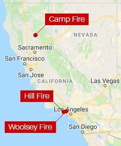
HUB Risk Services                                                            Sensitive          12 November 2018
California Wildfires                                                    For Official Use Only        07:00 AM PT

 State Fire Map

 The Garner Complex and Natchez fires, marked A&B on the map, are Oregon State Fires

     1. Essex Fire: CAL FIRE is assisting the Modoc National Forest with a fire east of
        Essex Reservoir, northeast of Canby (Modoc County). For more information go to:
        https://twitter.com/ModocNF

     2. Wilson Fire: CAL FIRE is assisting the Lassen National Forest with a new wildfire
        at Wilson Lake Rd and Lost Creek Rd, 10 miles northwest of Chester (Tehama
        County). For more information go to: https://inciweb.nwcg.gov/incident/6229/

     3. Camp Fire: [update] Pulga Road at Camp Creek Road near Jarbo Gap (Butte
        County) is now 111,000 acres and 25% contained. Evacuations in place. Unified
        Command: CAL FIRE, Butte County Sheriff Department, Paradise Police
        Department, and the USFS. For more information go to:
        http://www.fire.ca.gov/current_incidents/incidentdetails/Index/2277

     4. Brushy Fire: [update] near Dos Rios, off Highway 162, East of Highway 101
        (Mendocino County) is now 35 acres and 50% contained.

     5. Nurse Fire: This is not a CAL FIRE incident. CAL FIRE is assisting the Suisun
        City Fire Protection District with a 1,500 acre fire off Highway 12 and Nurse Blue
        Road, Suisun City (Solano County). #NurseFire is 90% contained.

     6. Donnell Fire: Currently 36,450 acres and 90% contained. This is not a CAL
        FIRE incident. For more information from the Stanislaus National Forest on this
        fire go to: https://inciweb.nwcg.gov/incident/6092/

     7. Lions Fire: Currently 13,347 acres and 85% contained. This is not a CAL FIRE
        incident. For more information go to: https://inciweb.nwcg.gov/incident/5850

     8. Eagle Fire: CAL FIRE is assisting the Sierra National Forest with a fire off Bobs
        Flat Trail, 3 miles north of Trimmer (Fresno County) This is not a CAL FIRE
        incident. For more information go to: https://twitter.com/Sierra_NF

                                                                             Sensitive
                                                                                                    Page 5 of 12
                                                                        For Official Use Only
HUB Risk Services Sensitive 12 November 2018
California Wildfires For Official Use Only 07:00 AM PT
9. Georges Fire: Assigned to the Inyo National Forest For more information go to: https://inciweb.nwcg.gov/incident/5907
10. Rincon Fire: [update] off Highway 9 and Rincon Crossing, north of Santa Cruz (Santa Cruz County) remains 17 acres and 100% contained. For more
information go to: http://www.fire.ca.gov/current_incidents/incidentdetails/Index/2275
11. Hill Fire: [update] at Hill Canyon Rd and Santa Rosa Rd, Santa Rosa Valley (Ventura County) per Ventura County Fire is now 4,531 acres and 75%
contained. For additional information go to: https://www.vcemergency.com/
12. Woolsey Fire: [update] at E St and Alfa Road Rd, south of Simi Valley (Ventura County) per Ventura County Fire is now 85,500 acres and 15% contained.
Unified Command: CAL FIRE, Ventura County Fire, LA County Fire, LA City Fire, LA Sheriff, and LAPD For more information go to:
http://www.fire.ca.gov/current_incidents/incidentdetails/Index/2282
13. Fork Fire: CAL FIRE is assisting the Angeles National Forest with a wildfire off East Fork Rd & San Gabriel Canyon Rd, Azusa (Los Angeles County).
For more information go to: https://inciweb.nwcg.gov/incident/6196/
14. Holy Fire: This is not a CAL FIRE incident. For additional information go to: https://inciweb.nwcg.gov/incident/6106/
Sensitive
Page 6 of 12
For Official Use OnlyHUB Risk Services Sensitive 12 November 2018
California Wildfires For Official Use Only 07:00 AM PT
Watches and Warnings
Current Red Flag Warnings
Sensitive
Page 7 of 12
For Official Use OnlyHUB Risk Services Sensitive 12 November 2018
California Wildfires For Official Use Only 07:00 AM PT
National Weather Service has issued HIGH WIND WARNINGS for Los Angeles County Mountains excluding the Santa Monica Range; Santa Monica Mountains
Recreational Area; Ventura County Mountains and for Orange County Inland; Riverside County Mountains; San Bernardino County Mountains; San Bernardino
and Riverside County Valleys-The Inland Empire; San Diego County Inland Valleys; San Diego County Mountains; San Gorgonio Pass Near Banning; Santa Ana
Mountains and Foothills
WIND ADVISORIES are issued for Los Angeles County Coast including Downtown Los Angeles; Los Angeles County San Fernando Valley; Los Angeles County
San Gabriel Valley; Santa Clarita Valley; Ventura County Coast; Ventura County Coastal Valleys; Ventura County Interior Valleys
Sensitive
Page 8 of 12
For Official Use OnlyHUB Risk Services Sensitive 12 November 2018
California Wildfires For Official Use Only 07:00 AM PT
National Weather Service has issued air quality alerts due to smoke impacts from surrounding wildfires. Areas affected are: Fresno; Kern; Kings; Madera;
Merced; San Joaquin; Stanislaus; Tulare. The alert is in effect until the fires are extinguished.
Impact: Exposure to particle pollution can cause serious health problems, aggravate lung disease, cause asthma attacks and acute bronchitis, and increase risk of
respiratory infections.
Instructions: Use caution as conditions warrant. People with heart or lung diseases should follow their doctor`s advice for dealing with episodes of unhealthy air
quality. Additionally, older adults and children should avoid prolonged exposure, strenuous activities or heavy exertion, as conditions dictate.
‘Unhealthy’ conditions persist
Sensitive
Page 9 of 12
For Official Use OnlyHUB Risk Services Sensitive 12 November 2018
California Wildfires For Official Use Only 07:00 AM PT
Wildfire Smoke Precautions
Eight Tips for Protecting Yourself from Breathing Wildfire Smoke
If possible, limit your exposure to smoke. Here are eight tips to help you protect your health:
1. Pay attention to local air quality reports and the U.S. Air Quality Index. When a wildfire occurs in your area, watch for news or health warnings about
smoke. Pay attention to public health messages and take extra safety measures such as avoiding spending time outdoors.
2. Pay attention to visibility guides if they are available. Although not every community measures the amount of particles in the air, some communities have
guidelines to help people estimate air quality based on how far they can see.
3. If you are told to stay indoors, stay indoors and keep your indoor air as clean as possible. Keep windows and doors closed unless it is very hot outside.
Run an air conditioner if you have one, but keep the fresh-air intake closed and the filter clean to prevent outdoor smoke from getting inside. Seek shelter
elsewhere if you do not have an air conditioner and it is too warm to stay inside with the windows closed.
4. Use an air filter. Use a freestanding indoor air filter with particle removal to help protect people with heart disease, asthma or other respiratory conditions
and the elderly and children from the effects of wildfire smoke. Follow the manufacturer’s instructions on filter replacement and where to place the device.
5. Do not add to indoor pollution. When smoke levels are high, do not use anything that burns, such as candles and fireplaces. Do not vacuum, because
vacuuming stirs up particles already inside your home. Do not smoke tobacco or other products, because smoking puts even more pollution into the air.
6. Follow your doctor’s advice about medicines and about your respiratory management plan if you have asthma or another lung disease or cardiovascular
disease. Call your doctor if your symptoms worsen.
7. Do not rely on dust masks for protection. Paper “comfort” or “dust” masks commonly found at hardware stores trap large particles, such as sawdust. These
masks will not protect your lungs from smoke. An “N95” mask, properly worn, will offer some protection. If you decide to keep a mask on hand, see the
Respirator Fact Sheet provided by CDC’s National Institute for Occupational Safety and Health.
8. Avoid smoke exposure during outdoor recreation. Wildfires and prescribed burns—fires that are set on purpose to manage land—can create smoky
conditions. Before you travel to a park or forest, check to see if any wildfires are happening or if any prescribed burns are planned.
Sensitive
Page 10 of 12
For Official Use OnlyHUB Risk Services Sensitive 12 November 2018
California Wildfires For Official Use Only 07:00 AM PT
Evacuation preparation:
• An evacuation alert is a notification of potential danger that might arise. An evacuation alert does not mean you have to evacuate; rather, you should be
prepared to evacuate with very short notice. Consider the following actions:
• Family members should:
o Agree on which evacuation resource center they’re traveling to
o Set up meeting a point in case of separation
o Establish an emergency contact who lives out of town that will be able to keep track of their whereabouts
• Pack an emergency kit or “go bag” to include items such as:
o Important paperwork like insurance and identification documents
o Medicine
o Non-perishable food
o Water (4 liters per person per day)
o Clothing for a few days
o Blankets
o Cash
o Comfort items for children
o Cellphone chargers
• Secure your home – you should do the following if it is deemed safe:
o Close doors and windows
o Close and latch gates, but leave them unlocked
o Shut off the water
o Switch electricity off
o Leave the natural gas "on."
• Officials say you should take your pets with you.
o However, you'll need to plan where to take them as many evacuation shelters do not allow animals.
o Household pets should be leashed or in a carrier. Find more information on animal evacuations.
Sensitive
Page 11 of 12
For Official Use OnlyHUB Risk Services Sensitive 12 November 2018
California Wildfires For Official Use Only 07:00 AM PT
For Additional Information:
CAL Fire
www.fire.ca.gov/
US Federal Emergency Management Agency
http://www.fema.gov/
FEMA – Mobile App
https://www.fema.gov/mobile-app
Emergency Management Agencies
https://www.fema.gov/emergency-management-agencies
Ready Gov
www.ready.gov
US Geological Survey
https://www.usgs.gov/program/wildfire-hazards
National Weather Service – Fire Weather
https://www.srh.noaa.gov/ridge2/fire/
https://graphical.weather.gov/sectors/northcaliforniaWeek.php
Wildfire Recovery Resources
https://wildfirerecovery.org/
California Gov - Alerts
https://ca.gov/#alertsection
American Red Cross – Active Wildfire Map
https://www.redcross.org/get-help/how-to-prepare-for-emergencies/types-of-emergencies/wildfire
Listo Gov (Spanish)
www.listo.gov
Smart Traveler Enrollment Program
https://step.state.gov/
Sensitive
Page 12 of 12
For Official Use OnlyYou can also read