National Significant Wildland Fire Potential Outlook - Predictive Services
←
→
Page content transcription
If your browser does not render page correctly, please read the page content below
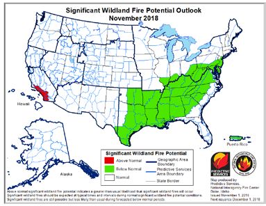
National Significant Wildland Fire Potential Outlook
                          Predictive Services
                    National Interagency Fire Center
                       Issued: November 1, 2018
                       Next Issuance: December 1, 2018

Outlook Period – November, December and January through February 2019
                                             Executive Summary
                     The significant wildland fire potential forecasts included in this outlook
                     represent the cumulative forecasts of the ten Geographic Area
                     Predictive Services units and the National Predictive Services unit.

                     Much of the West exited fire season by early October as the frequency
                     of wet systems moving across the country increased. Cooler
                     temperatures brought higher humidity levels and good overnight
                     recoveries which also reduced large fire potential. As anticipated, the
                     frequency of Santa Ana and North Wind events across California was
                     lower than average, so critical fire weather periods were infrequent and
                     of short duration. Nevertheless, fire activity was observed in isolated
                     locations across the region in the remaining pockets where fuels
                     remained critically dry. The Klondike fire made large runs mid-month.
                     In the East, fire activity was also less active than average. This was due
                     to the onset of a weak El Niño which promoted wetter than average
                     conditions. The primary draw on resources was in response to
                     Hurricane Michael which made landfall at Mexico Beach, Florida, with
                     155 mph winds.

                     While most regions of the country are out of fire season during
                     November, varying levels of activity are observed across California and
                     the Southeast. The onset of El Niño should allow for a continuance of
                     wetter than average conditions across the Southeast which should limit
                     fire activity. However, pockets of critically dry fuels will persist across
                     California, especially along coastal areas and along the front of the
                     Southern Sierra. These areas will remain susceptible during wind
                     events.

                     Climatologically speaking, fire activity during the winter months,
                     December through February, is at a minimum. Areas most susceptible
                     to activity are generally restricted to the southeastern states where
                     periodic increases in fire activity are possible during dry periods until
                     spring greenup begins. However, current data and expected trends in
                     precipitation suggest that large fire potential will be Below Normal in
                     this region. The abundance of moisture should keep fuels in most areas
                     from becoming critically dry. Drought forecasts project that the region
                     should remain mostly free of drought.

                     Across the West, overall warmer and drier than average conditions are
                     expected. This should lead to below average snowpack in most
                     mountain locations across the northern tier of the country. Snowpack
                     should trend toward average levels moving south along the Continental
                     Divide as the impacts of the El Niño begin to produce a positive effect
                     on precipitation amounts received.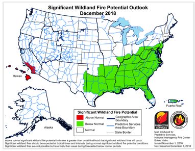
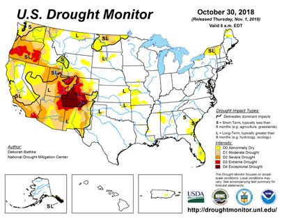
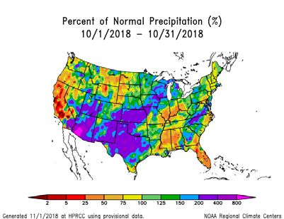
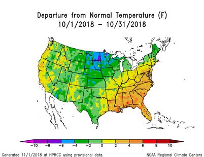
Past Weather and Drought

Temperatures across the Intermountain West and along the West Coast were generally near average to 3
to 6 degrees above average during October as a series of high pressure ridge events proved to be the
dominant features. Across the central portion of the country, the Great Plains and Great Lakes regions,
temperatures were generally 9 t0 12 degrees below average early in the month but recovered to be just
slightly below average by month’s end. This was in response to a persistent trough of low pressure that
continually pulled colder air down from Canada. In the Southeast, temperatures were generally 2 to 6
degrees above average with some warmer spots as was the Northeast until the third week of the month
when some cooling occurred due to an eastward migration of the upper level trough and pushed
temperatures down to be below average. Precipitation amounts were generally above average across
most of the country. Exceptions to this were across the northern two thirds of California, southern-western
Oregon, and along the Canadian Border between Washington and North Dakota where precipitation
amounts received were generally less than 50% of average. The Floridian Peninsula also experienced
below average precipitation as well as did Mississippi and Alabama.

The western drought persisted during October, but there were signs of improvement. Texas and Arizona
saw the most improvement as did portions of Montana, the Dakotas, and Utah. Some deepening of drought
conditions was observed along the state lines of Nevada, Utah, and Idaho. Looking forward, some
improvement in preexisting drought conditions are expected across the southern half of the Four Corners
region and west of the Cascade Crest through January. A persistence of drought conditions are forecasted
across Southern California, most of the Great Basin, eastern Oregon, and portions of Montana and the
Dakotas.

 Left: Departure from Normal Temperature (top) and Percent of Normal Precipitation (bottom) (from High Plains Regional Climate
 Center). Right: U.S. Drought Monitor (top) and Drought Outlook (bottom) (from National Drought Mitigation Center and the Climate
 Prediction Center)
Weather and Climate Outlooks
Latest sea surface temperature anomalies across the equatorial Pacific
Ocean indicate that a weak El Niño event has begun. Temperature
depth profiles and upwelling of warmer waters from beneath suggest
that further warming is expected. Latest forecast data strongly indicate
that the event should last through the winter months and into the spring
before slight cooling of ocean water temperatures begins to occur.
Weather patterns in association with the event are expected to follow
climatological trends. Wetter than average conditions are expected
across the south central and southeastern states. Overall warmer and
drier than average conditions are expected across the northwestern
quarter of the country while a trend towards average conditions is
expected across the southwestern quarter of the nation except
California where drier than average conditions are expected. Mountain
snowpack accrual should be below average across the northwest and
near average across the southwest.
Geographic Area Forecasts
Alaska: Normal significant wildland fire potential is expected for the
region during the outlook period.
Abnormally Dry conditions in the northern Alaska Panhandle and severe
drought conditions in the southern Panhandle persist while the rest of
the state has received ample precipitation this fall, with heavy rains in
parts of the Interior and the Gulf Coast.
Warmer than average conditions are expected in November for all of
Alaska this winter, with a focus in western and northwestern Alaska,
particularly along the coast. This is likely due to the extremely low sea
ice content of the Chukchi Sea this fall. Wetter than average conditions
are expected to occur in the west and south, with the focus shifting to
southeast by December. This should moderate the drought in the
Panhandle this winter.
Calculations of the Canadian Forest Fire Danger Rating System have
all been turned off for the season as temperatures are mainly in the 30s
and 40s, the ground is frozen or even snow-covered in most areas, and
ignitions are unlikely.
Alaska is out of fire season with little to no fire activity expected through
the winter, which is normal.
Northwest: Normal significant large fire potential is expected across the
region during the outlook period.
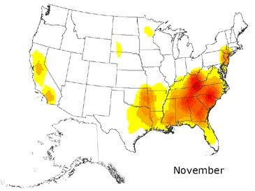
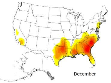
After an unusually warm and dry summer, the first month of autumn Normal fire season progression across the
contiguous U.S. and Alaska shown by
brought more seasonable weather to the east side of the region, while monthly fire density (number of fires per unit
the Cascades and western areas remained a bit warmer and area). Fire size and fire severity cannot be
significantly drier than average. Most of the Pacific Northwest continued inferred from this analysis. (Based on 1999-
2010 FPA Data)
to see Abnormally Dry to Extreme drought conditions, with only the
northwestern corner of the region recovering with the rainfall that was
received in August and September.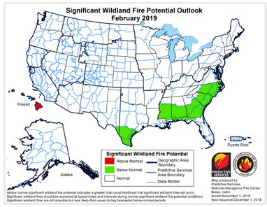
The latest climate outlooks suggest temperatures will be above average for the region through the winter.
Precipitation shows a below average bias for November, but no clear signal for the December–February
period. The outlook is based in part on the expectation for development of a weak El Nino, which would
suggest a mild winter in all areas. The US Drought Outlook projects persistent drought conditions for
eastern Oregon and small parts of eastern Washington, while conditions across the rest of the region are
expected to improve.

After remaining at or near record levels for much of July and August, ERC and 100-hour fuel moisture
levels finally dropped to seasonal levels under the influence of marine air in September. A two week
stretch of warm, dry weather in the middle of October reduced 100-hour fuel moisture to new record lows
for several PSAs, but significant precipitation over the next week returned all fire danger indices to average
levels at the beginning of November.

Cooler, moister conditions reduced fire behavior during September with less than a dozen new large fires
and generally low growth on exiting incidents. October saw only two new large fires as the combination of
fire danger and weather was no longer favorable to development of new significant fires.

Northern California and Hawaii: Normal significant large fire potential is expected across mainland
portions of the region and Hawaii during the outlook period except across Hawaii after November when
Above Normal potential will exist.

The great majority of rainfall that occurred in October did so during the first week. Other than small areas
in the northeastern and southwestern portions of the region, most areas received less than 75% of average
amounts. The U.S. Drought Monitor shows a large portion of the region in the Abnormally Dry category
with a growing area of Moderate Drought conditions west of the Sacramento River and a small area of
Severe Drought conditions near the Oregon state line. While only light rainfall amounts are expected in
early November, precipitation amounts and frequency should pick up by mid-month. Fuels remain at or
near record dryness levels entering the outlook period, and local areas with dry and breezy conditions will
still have a moderate risk of significant fires during the first few days of the month. Although the outlook
calls for drier than average conditions in November, cool and damp conditions will bring significant fire
potential down to average levels by the middle of the month. Occasional rainfall and mountain snow events
through February, along with the long cool nights, will keep evaporation and evapotranspiration rates low.
Therefore, all areas have Normal Significant Fire Potential from November through February.

Sea surface temperatures surrounding the Hawaiian Islands are above average to the south and near
average on the north side of the region. Average temperatures throughout the region are expected to
continue to remain so through February. Rainfall in October was above average from the central islands
east to the Big Island, and below average at the western end. The potential of El Niño conditions in the
equatorial Pacific beginning this winter is more than 70%, and this pattern tends to produce drier than
normal conditions during the Hawaiian rainy season. The official outlook for Hawaii calls for near average
rainfall in November, then trending to below normal rainfall from December through the winter and spring
months. The Large Fire Potential for Hawaii is Normal in November. Fuel loading has been above average
since the spring, and fire activity was above average during the drier stretches of the summer. Therefore,
the Large Fire Potential for Hawaii is Above Normal from December 2018 through February 2019 as a
drier than average rainy season evolves.

Southern California: Above Normal significant wildland fire potential is expected along the coast and
foothills across Southern California in November and December. For January and February, Normal
significant large fire potential is expected in all areas. Areas not mentioned above can expect Normal
significant large fire potential in November and December.

A few periods of warm and dry weather occurred during the past month, but overall, the severity of October
2018’s fire weather pales in comparison to the past several years. Often, October is the one of the hottest,
driest months of the year. While some 100 degree readings occurred across inland areas, the average
daily temperature for the past 30 days was just a bit above average. There were two storms which brought
widespread and significant rainfall, both of which occurred during the 2nd week of the month. Southern
California, in particular, saw sizeable rainfall totals as a weak low steered remnant tropical moisture into
the area.

The rainfall did cause a pause in wildfire activity across the area as fuel moisture climbed to above
average levels. But since these rains occurred much earlier than usual, several days of dry, offshore flow
followed, causing fire danger to climb back to high levels. Dead fuel moisture dropped rapidly and critical
fire weather conditions occurred scarcely a week after the rainfall due to a strong Santa Ana wind event.
There is an historical precedent for fire weather conditions closely following wetting rains in the fall as the
Freeway Fire in 2008 occurred only a few days after a wetting rain.

Large fire potential is expected to drop from north to south across the district as long nighttime hours,
cooler temperatures and a low solar angle collude to lower the fire danger despite the dryness of the fuels.
Most fire activity going forward will be limited to periods of prolonged, and at least, moderate, offshore flow.
There are, on average, 3 moderate to strong offshore wind events in both November and December and
this year, an average number of events is expected. Long range models indicate a drier than normal
November may be on tap which means a few more offshore wind events will likely precede the next period
of significant wetting rains. But there are indications a cooler, wetter pattern may develop in December
which should result in large fire potential returning to near normal across the entire region. A normal
number of large fires (i.e. zero) are expected in January and February.

Northern Rockies: Normal significant large fire potential is expected across the region during the outlook
period.

In October, areas along and east of the Continental Divide received slightly above average precipitation,
but generally speaking, the early fall brought a persisting trend of dry conditions to the region. Western
Montana, along the Continental Divide, saw a few rounds of accumulating snow, but the highest
precipitation amounts observed were in eastern North Dakota with an early-season snow storm from
October 9th – 11th. Temperatures in October were much below average in North Dakota and Montana
east of the Continental Divide, and slightly below average across western Montana and Idaho. This was
due to a very cold, Canadian weather system that moved into the northern Great Plains mid-month. This
was followed by a strong ridge of high pressure over the entire northwest US with warm days but a
continuation of cold, dry nights.

Moderate to severe drought continued along the Canadian border in the Idaho Panhandle, northwest
Montana, and the northern half of North Dakota, with Abnormally Dry conditions across much of the Idaho
panhandle and north central Montana. Drought is expected to continue or worsen in the Idaho Panhandle
and northwestern Montana and the northern half of North Dakota through the winter.

Last winter’s abundant precipitation led to a heavy fine fuel load of grass in the eastern PSAs. Considering
the strong climate signal for a weak El Niño event and the resulting drier than average conditions in the
Northern Rockies, these fuels may still be available to burn for the remainder of the Fall season until there
is sufficient rain and/or snow cover. Current fire danger indices remain low and there is an expectation of
getting moisture during the first week of November.

Increasingly longer nights, cold night-time temperatures, and shorter daily burn periods have led to strong
inversions and overall fuel conditions are not critically dry. These trends are expected to continue a Normal
significant large fire potential for all areas of the Northern Rockies through the outlook period.

Great Basin: Normal significant large fire potential is expected across the region during the outlook period.

Over the last 30 days precipitation has been above average across most of the the Great Basin. The only
areas that have seen below normal precipitation are along the Sierra Front into northwestern Nevada and
across parts of eastern Idaho into Wyoming. Temperatures have been several degrees below average
across the entire Great Basin. Severe to extreme drought persists across the eastern half of Utah, with
severe drought observed further north into Utah and far southern Idaho and northeastern Nevada.

Moderate drought to abnormally dry conditions continue farther west across much of Nevada and Idaho
into Wyoming. Exceptional drought has developed due to prolonged recent dry and warm weather across
parts of southeast Utah. Wet and cooler weather should return to Utah, Wyoming and parts of Idaho in
November, however much less precipitation is expected across western and northern Nevada into far
southwestern Idaho.

Significant Large Fire activity decreased rapidly by early to mid-October after significant wet and cool
weather moved across the region. Although fire activity has decreased, there still may be some areas of
concern heading into November across western and northwestern Nevada into southwestern Idaho.
These areas did not see as much wetting rain as areas further east. There is also a well above average
fine fuel crop that could quickly dry out during long periods of dry and warm weather. This grass crop will
continue to elevate the potential for fire activity for a burning period or two after dry periods and on windy
days. However, on most days, fire potential will be normal.

Normal significance large fire potential is expected across the Great Basin from November through
February with low fire activity due to cooler temperatures and longer nighttime periods, despite any
precipitation. However, after dry periods even throughout the fall and winter, brief increased fire potential
or even large fires are possible on windy days for a burning period or two due to the above average fine
fuel load after periods of very dry weather.

Southwest: Normal significant large fire potential is expected across the region during the outlook
period.

Given the ongoing onset of an El Nino state in the eastern-central Pacific Ocean this fall the overall
expectation is for average to above average precipitation to occur for the region through the forecast time
frame. Confidence in this overall outlook is above average as the expected wet trend for the coming winter
months is already developing. In addition, overall temperatures are expected to be below average as well
during the outlook period though a few warm and dry periods may be observed here and there. Mountain
snowpack is expected to be at least average if not above average given the expected wetter than average
conditions this winter.

Rocky Mountain: Normal significant large fire potential is expected across the region during the outlook
period.

October was cooler and wetter the average over a large portion of the region. Drier areas were constrained
to northwestern Wyoming and south-central Colorado, along with average to slightly above average
temperatures observed across southwestern Colorado. Long range drought trends have abated
somewhat across the region. That said, Exception drought conditions linger across southern Colorado.

Late October ERC reports show stations average to below average across the region. Abundant fine fuel
loading over the lower elevations in northern portions of the geographic area has been mitigated by a
relatively wet pattern during the late summer and early fall. Mountain locations are showing snow cover
over the higher elevations which is above average for this time of year. Values are closer to average in the
mountains of northwestern Wyoming.

Short term forecast precipitation for early November indicates a trend toward below average precipitation.
Temperatures should be near average with occasional breezy conditions developing with frontal passages
and/or downslope wind events. Consensus long term forecasts for fall and winter lean toward an
average to warmer than average period for northern portions of the area along with average to below
average precipitation. Southern areas can expect near average temperatures and precipitation during the
outlook period.

Critically dry fuel moistures and associated large fire risk in late September across north-central and
northwestern Colorado into south-central to southwestern Wyoming moderated significantly during
October. Abundant fine fuel loading over the lower elevations in northern portions of the geographic area
has been mitigated by a relatively wet pattern during the late summer and early fall. Long range outlooks
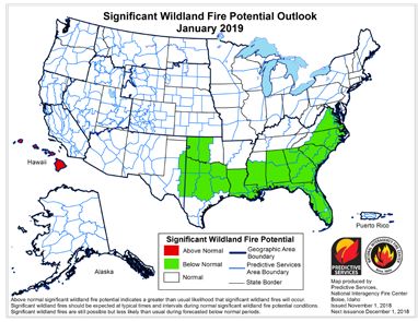
for the remainder of fall into the winter point toward an average/out of season fire regime for the Rocky
Mountain Area. Fire history for the geographic area shows a continued drop-off in large fires from
November-January especially after the first week of November, with the primary focus (short duration wind
driven) over the lower elevations and grasslands, especially east of the divide.

Eastern Area: Near to Below Normal significant large fire potential is expected over the majority of the
Eastern Area during the outlook period.

Thirty-day soil moisture and precipitation anomalies were slightly below average across parts of the Ohio
Valley and New England in late October. Well above average precipitation and soil moisture anomalies
were in place over Iowa, Wisconsin, southeastern Minnesota, parts of the Mid-Atlantic States and southern
New York.

Drier than average conditions overall are forecast across the Upper Mississippi Valley in November. Wetter
trends are expected to continue across the Ohio Valley into the Mid-Atlantic States November into
December. Below average temperatures are forecast across much of the Eastern Area in November.
Above average temperatures trends are expected to develop over the western Great Lakes December into
January. Cooler than average conditions may develop over the eastern states January and February.

Hundred- and thousand-hour fuel moistures were near or above seasonal averages and Energy Release
Components or Canadian Build-Up Indices were near below seasonal average levels toward the end of
October over the majority of the Eastern Area. The late fall 2018 fire season will likely continue to be
diminished over much of the Eastern Area where wetter than average conditions develop and/or persist.

Southern Area: Below Normal significant wildland fire potential is expected throughout the outlook period
except in areas shown on the maps above where Normal significant wildland fire potential is expected.

While the winter outlooks indicate temperatures to be average to above average for the region, there are
other considerations that point toward a possibility that a cooler than average trend could develop. The
possibility for cooler than average conditions suggests a higher potential for southern/eastern snow events
this winter. Forecast weather patterns should be closely monitored for the development of high latitude
blocking patterns and for the potential development a strong high pressure ridge in the West this early this
winter. The development of either will yield clues to whether or not the cooler than average conditions will
develop.

The presence of a subtropical Atlantic high pressure area will likely continue to reduce the potential for
higher amounts of recurring rainfall across Florida early on. However, some rainfall and higher humidity
are still expected which should keep large fire potential from exceeding normal thresholds. Across Puerto
Rico, a declining but still somewhat active tropical pattern should keep seasonal rainfall on track through
November before the dry, post tropical season develops during the later periods of the outlook.

There are currently two areas, eastern North Carolina and the Florida peninsula, where short term rain
deficits have emerged. Drier than average rain anomalies continue to build across the Floridian peninsula
with 30 day deficits ranging from one to three inches below average with embedded areas along the
eastern coast reaching into the three to five inch range. Observed rain fall has been in the one to two and
a half inch range. For eastern North Carolina, October rainfall amounts were in the one half to two inch
range which were 75% or less of average. A few locations within this area received just 10% of average
for the month. Despite these deficits, the region remains mostly drought-free.
Fire activity across the region has been minimal and much below average due to prior heavy rainfall activity
from the recent major hurricanes that made landfall on the Atlantic and Gulf Coasts. Fire danger is
expected to remain low during the outlook period. For Puerto Rico, areas along the southern coast could
see some elevated potential evolve through and the outlook period. This will need to be monitored as the
normally seasonally dry months approach.
Outlook Objectives

The National Significant Wildland Fire Potential Outlook is intended as a decision support tool for wildland
fire managers, providing an assessment of current weather and fuels conditions and how these will evolve
in the next four months. The objective is to assist fire managers in making proactive decisions that will
improve protection of life, property and natural resources, increase fire fighter safety and effectiveness,
and reduce firefighting costs.

For questions about this outlook, please contact the National Interagency Fire Center at (208) 387-
5050 or contact your local Geographic Area Predictive Services unit.
Note: Additional Geographic Area assessments may be available at the specific GACC websites. The GACC websites can also
be accessed through the NICC webpage at: http://www.nifc.gov/nicc/predictive/outlooks/outlooks.htm
You can also read