Hydrology from Space: NASA's Satellites Suppor8ng Water Resources Applica8ons
←
→
Page content transcription
If your browser does not render page correctly, please read the page content below
Hydrology
  from
  Space:
  NASA's

 Satellites
  Suppor8ng
  Water

   Resources
  Applica8ons


                      Margaret Srinivasan
                   Jet Propulsion Laboratory
               California Institute of Technology
                         Pasadena, CA

           Water Forum III: Droughts and Other Extreme Weather Events!
                     University of Texas -- 14 October 2013!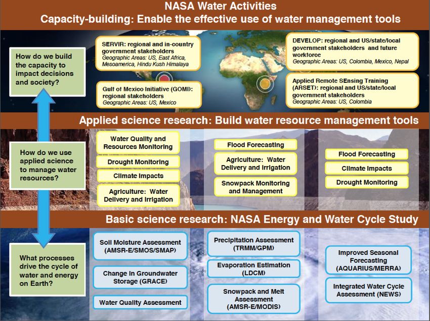
Special Thanks to: !
   Erik Ivins, JPL !
   John Bolten, GSFC!
Deputy Program Applications Leads!
GRACE-FO*!
!
&!
Srinivas Bettadpur, UTCSR!
Dalia Kirschbaum, GSFC!
Simon Hook, JPL!
Tim Liu, JPL!
Karen Yuen, JPL!

              Water Forum III: Droughts and Other Extreme Weather Events!
                        University of Texas -- 14 October 2013!                                                                   2

 *Proposed Missions – Pre-decisional – for Planning & Discussion Purposes Only – All figures on this page are Artists’ Concepts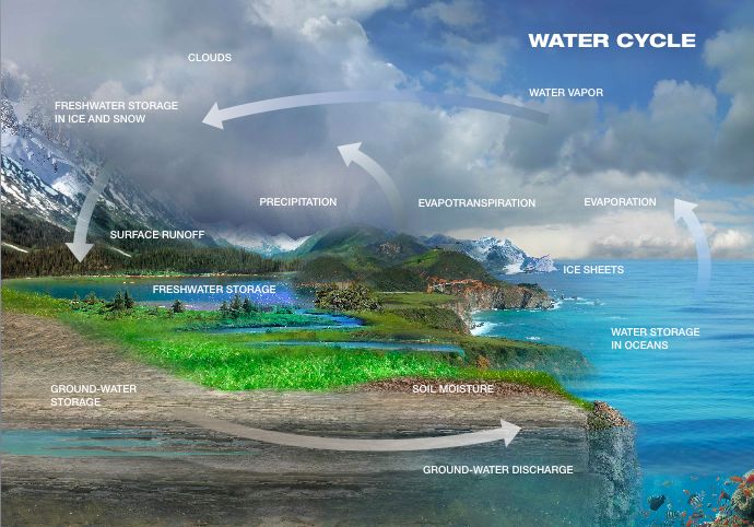
Overview


•   NASA Applied Sciences Applications program!
•   Water budget balance!
•   NASA missions supporting hydrology studies !
•   Summary: Survey!

            Water Forum III: Droughts and Other Extreme Weather Events!
                      University of Texas -- 14 October 2013!             3
NASA
  Earth
  Science

The NASA Earth Science Division
supports basic and applied research on
                                                             Science
the Earth system and its processes. "                      Requirements!
                                                                             !
"
Significant efforts are to characterize and                   Technology !
understand Earth system processes and                                        !

to improve predictions of the Earth                              Missions !
system."                                                                     !

"
In the course of Earth science, NASA
                                                                Research !
                                                                             !
pursues innovative and practical
applications of Earth observations and                     Data Systems!
                                                                             !
new scientific knowledge to improve public
and private organizations’ decision-making                   Applications!
activities. "

               Water Forum III: Droughts and Other Extreme Weather Events!
                         University of Texas -- 14 October 2013!                 4
NASA
  Applied
  Science
  Program

NASA’s Applied Science Program supports applications
activities for early phase missions based on Earth Science
Decadal Survey (NRC, 2007)"

    NASA Applied Science Program!
    Mission project office"
    Science Team!
    User community (you!)!

Goal: Develop a mature applications program at the project level,
    supported by NASA HQ and the mission science teams

           Water Forum III: Droughts and Other Extreme Weather Events!
                     University of Texas -- 14 October 2013!             5

Program
Near-‐Term
Goals
"
• Assess & engage ‘Community of Practice’,
‘Community of Potential’"
• Identify commonalities between mission
requirements & needs of known applications/
users;"
• GRACE applications-focused web site "
• Database of user community"
• Applications Plan"
• User Workshops – joint missions"
"
Water Forum III: Droughts and Other Extreme Weather Events!
University of Texas -- 14 October 2013! 6

Applica3ons
Considera3ons
• Broaden
user
community
and
range
of
applica8ons
• Data
accessibility,
latency,
and
usability
• Data
processing
/
data
edi8ng
- Data
format
(e.g.,
typical
GRACE
applica8on
user
wants
a
gridded
data
product)
- The
most
“interes8ng”
or
useful
applica8ons
are
oTen
at
small
spa8al
scales
- Need
a
product
that
can
meet
user
needs,
with
reliable
uncertainty
es8mates
- More
L3-‐type
products
need
to
be
explored
• Objec8ve
informa8on
>
Decision
support
tools
• Comprehensive
/
integrated
effort
Water Forum III: Droughts and Other Extreme Weather Events!
University of Texas -- 14 October 2013! 7
Applied
  Sciences
  Water
  Ac3vi3es


         Water Forum III: Droughts and Other Extreme Weather Events!
                   University of Texas -- 14 October 2013!             8
Water
  Cycle


Water Forum III: Droughts and Other Extreme Weather Events!
          University of Texas -- 14 October 2013!             9
Water
  Balance
  Equa8on

     Describes the flow of water in and out of a system
            (drainage basin, soil column, etc.)!
                                          !
                                          !

"
                    ΔS = P – Q – E "
    Where;"
     S is water storage"
     P is precipitation "
     Q is runoff"
     E is evaporation"
     "
              Water Forum III: Droughts and Other Extreme Weather Events!
                        University of Texas -- 14 October 2013!             10
Water
  Balance
  Equa8on


               ΔS = P – Q – E !                   "

NASA assets that inform these elements;!
  !

   S (water storage); GRACE, SMAP,
    SWOT*, "GRACE-FO*"
   P (precipitation); TRMM, GPM "
   Q (runoff); SWOT*, "
   E (evaporation); Meteosat, MODIS,
     "Landsat, HyspIRI*"
  "
           Water Forum III: Droughts and Other Extreme Weather Events!
                     University of Texas -- 14 October 2013!                                       11

                   *Proposed Missions – Pre-decisional – for Planning & Discussion Purposes Only
Solu8ons
During
Drought
NASA satellite data products and contributions to
drought monitoring can help to determine when the
following actions should be taken:!
!
•Increasing on-farm reservoir storage for water supply.!
•Assessing regional surface wetness to infer water availability
for pumping for domestic supply.!
•Assessing aquifer levels supplying communities and farms.!
•Assessing lake levels for irrigation, recreation and fishing.!
•Assessing the adequacy of water availability for hydroelectric
power generation.!
Water Forum III: Droughts and Other Extreme Weather Events!
University of Texas -- 14 October 2013! 12
Support
for
U.S.
Drought
Monitor
NASA
Funding
Several
Projects;
• Expedited MODIS Vegetation Drought Response Index (VegDRI) &
Soil Moisture Change: USGS/EROS and NDMC have integrated
MODIS into the national ‘VegDRI model’ on a rapid, weekly schedule.
JPL automated a procedure to provide Soil Moisture Change updated
projects.
• Prototype Terrestrial Water Storage (TWS) Using GRACE Satellite
Data: NASA GSFC and NDMC working to provide GRACE TWS data
assimilated in to land surface models for a new key drought indicator
including deep soil moisture and ground water.
• Resolution Benchmark: NASA results have excellent resolutions to
resolve the county-level goal of NIDIS. This is evident in the comparison
of SMC, TWS and VegDRI products versus USDM drought maps at the
higher resolution.
• Improvements of USDM are important for users: NOAA NWS uses
‘D2’ to trigger drought information statements, IRS for tax deferrals,
USDA programmatic usage, and Livestock Forage Disaster Program
disbursement ($147,109,381 in 2008, and $77,608,125 in 2009).
User community interactions:
Drought Forum 2009 Water Forum III: Droughts and Other Extreme Weather Events!
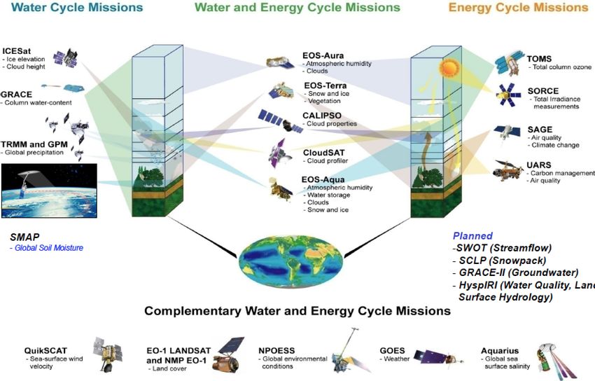
University of Texas -- 14 October 2013!NASA’s
Water
and
Energy
Cycle
Missions
Proposed
Water Forum III: Droughts and Other Extreme Weather Events!
University of Texas -- 14 October 2013! 14
*Proposed Missions – Pre-decisional – for Planning & Discussion Purposes OnlyNASA’s
Water
and
Energy
Cycle
Missions
Proposed
Missions
suppor8ng
hydrology
science
Water Forum III: Droughts and Other Extreme Weather Events!
University of Texas -- 14 October 2013! 15
*Proposed Missions – Pre-decisional – for Planning & Discussion Purposes OnlyGRACE
2002-‐present
Gravity
Recovery
And
Climate
Experiment
-‐
Applica3ons
• Water Resources Assessments!
- Drought monitoring"
- Ground water depletion"
- Seasonal snow load"
- Streamflow forecasting (based on upland water storage)"
- Transboundary water resources sharing"
- Flood stage and risks (UCI work)"
• Weather and Climate Prediction!
- Via improved forecast model land surface state initialization"
- Implications for Water Resources, Agriculture, and Disaster
Preparedness"
Several
agencies
are
using
or
considering
the
use
of
GRACE
data
in
their
decision
making
processes:
• State
of
California
2013
Water
Plan
• NOAA
Drought
Mi8ga8on
Center
Water Forum III: Droughts and Other Extreme Weather Events!
• Interna8onal
Center
for
ofBTexas
University iosaline
Agriculture,
-- 14 October 2013! Dubai,
UAE
16
GRACE-based Drought Indicators

   GRACE terrestrial
        water storage
       anomalies (cm
 equivalent height of
water) for June 2007.

   New process integrates data from GRACE and other
   satellites to produce timely information on wetness
   conditions at all levels in the soil column, including
   groundwater. For current maps and more info, see
   http://www.drought.unl.edu/MonitoringTools.aspx                   U.S. Drought Monitor product for 26 July 2011.

                        Surface Soil Moisture           Root Zone Soil Moisture                     Groundwater

                           Drought indicators
                               Water Forum III:from GRACE
                                                Droughts  and data
                                                              Otherassimilation (wetness
                                                                     Extreme Weather     percentiles
                                                                                     Events!
                                          University of Texas  -- 14 October 2013!
                                   relative to the period 1948-present) for 26 June 2007.                             17
TRMM
Launched:
1997
Tropical
Rainfall
Measuring
Mission
• Launched
in
1997
to
measure
tropical
rainfall
• Currently
has
an
nearly
16-‐year
record
of
precipita8on
• Partnership
between
NASA
and
the
Japan
Aerospace
Explora8on
Agency
(JAXA)
http://pmm.nasa.gov
Tropical Storm Ingrid on Friday, Sept. 13th
TRMM PR recorded “hot towers” (red) that often signal a tropical cyclone will intensify
Triggered huge landslides and flooding
Water Forum III: Droughts and Other Extreme Weather Events!
University of Texas -- 14 October 2013! 18
Jason
Series
Jason-‐3
Launch:
2015
Ocean
surface
topography
measurements
-‐
al3metry
TOPEX/Poseidon,
1992-‐2006
Jason-‐1,
2001-‐2013
OSTM/Jason-‐2,
2008-‐present
European;
Envisat,
ERS,
Saral/Al8Ka,
etc,
1995-‐2013
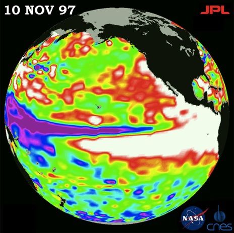
• El
Niño/La
Niña
• Ocean
Currents
• Tides
Water Forum III: Droughts and Other Extreme Weather Events!
University of Texas -- 14 October 2013! 19
Jason
  Series

    Hydrology applications; River & Lake surface height measurements for
    long-term storage monitoring (> 20 years time series)

                  Water Forum III: Droughts and Other Extreme Weather Events!
http://www.pecad.fas.usda.gov/cropexplorer/global_reservoir
                            University of Texas -- 14 October 2013!                           20

Source: C. BirkettJason-‐Series
Jason-‐3
Launch:
2015
Hydrology
applica-ons;
• Flood
forecas8ng
–
developing
applica8on
Forecas8ng,
calibra8on
of
hydrodynamic
models,
assimila8on
of
river
height
data
Ø Informa8on
for
improving
accuracy
of
predic8ons
Ø Will
be
available
to
stakeholders;
water
managers,
NGO’s,
water
resource
&
planning
agencies,
crop
modelers,
ecological
forecasters,
climate
adapta8on
community,
land
management
agencies.
Ø Immediate
applica8on
of
the
toolbox
by
Flood
Management
Div
of
the
Ins8tute
of
Water
Modeling-‐Bangladesh
to
extend
flood
forecast
lead
8me
to
5+
days
Water Forum III: Droughts and Other Extreme Weather Events!
University of Texas -- 14 October 2013! 21
Upcoming
  &
  Proposed
  Earth
  Missions

      suppor8ng
  hydrology
  science


SMAP 2014

            GPM 2014
                                      GRACE-FO* 2017

                                                                           SWOT* 2020

                                                                                                          NISAR* 2021

                                                                                                                                        HyspIRI* 2022

                         Water Forum III: Droughts and Other Extreme Weather Events!
                                   University of Texas -- 14 October 2013!                                                                       22

            *Proposed Missions – Pre-decisional – for Planning & Discussion Purposes Only – All figures on this page are Artists’ Concepts
SMAP
Soil
Moisture
Ac3ve
Passive
Mission
Launch:
2014
Weather & Climate Forecasting:!
• Soil moisture variations affect the evolution of weather and climate over continental
regions. "
• Accurate soil moisture information enhances the skill of numerical weather prediction
and seasonal climate models."
• Improved seasonal climate predictions will benefit water management, agriculture,
and fire, flood and drought hazards monitoring."
Drought:!
• Soil moisture strongly affects plant growth and hence agricultural
productivity, especially during conditions of water shortage and
drought. "
• With no global in situ network for soil moisture monitoring, global
estimates of soil moisture and plant water stress must be derived
from models. "
• These model predictions (and hence drought monitoring) can be
greatly enhanced with SMAP observations."
Artist’s Concept
Water Forum III: Droughts and Other Extreme Weather Events!
University of Texas -- 14 October 2013! 23
GPM
                                           Launch:
  2014


Global
  Precipita3on

Measurement

• GPM
  builds
  upon
  TRMM’s

  concept
  and
  will
  look
  at

  precipita8on
  with
  greater

  accuracy
  around
  the
  world

• GPM
  will
  use
  inputs
  from
  an

  interna8onal
  constella8on
  of

  satellites
  to
  provide
  improved

  space
  and
  8me
  coverage
  of
               TRMM radar (PR) cross-sections of hurricanes
  precipita8on
                                        available in real-time for operational analysis

                                      h2p://gpm.nasa.gov


                        Water Forum III: Droughts and Other Extreme Weather Events!
                                  University of Texas -- 14 October 2013!                          24
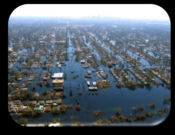
Flooding
                                            GPM
                                         Applica3ons


             Land surface and climate modeling

                                                  Landslides

 Freshwater Availability                                                             Extreme Events

                                   The rain and snow data
                                   gathered from the TRMM
                                   and GPM missions already
Agriculture/Famine Early Warning
                                   provide and will extend our                       World Health
                                   capabilities to study a wide
                                   range of applications for
                                   scientific research and
                                   societal benefit.

                       Water Forum III: Droughts and Other Extreme Weather Events!
                                 University of Texas -- 14 October 2013!                            25
GRACE-‐FO*
Hydrology:
Projected
Launch:
2017
• Groundwater
is
a
useful
indicator
of
climate
variability
and
human
impacts
on
the
environment.
• Combining
GRACE
data
with
hydrologic
modeling
enables
scien8sts
and
water
managers
to
observe
the
dynamic
changes
in
groundwater
over
large
regions
or
where
well
data
is
sparse.
• GRACE-‐FO*
would
con8nue
to
provide
global
measurements
of
the
hydrological
cycle.
• These
measurements
provide
informa8on
on;
– seasonal
and
inter-‐annual
river
basin
water
storage
changes,
– human
influences
on
regional
water
storage
changes,
– large-‐scale
evapotranspira8on,
– land-‐ocean
mass
exchange
– con8nental
aquifer
changes.
Artist’s Concept
Water Forum III: Droughts and Other Extreme Weather Events!
University of Texas -- 14 October 2013! 26
*Proposed Missions – Pre-decisional – for Planning & Discussion Purposes OnlySWOT*
Surface
Water
and
Ocean
Topography
Projected
Launch:
2020
Floods:
• Flooding
hydraulics
are
currently
well
modeled
but
poorly
measured.
• SWOT*
would
provide
water
level
records
for
flooding
events
that
underlay
a
given
satellite
overpass.
• SWOT*
scien8sts
would
also
be
able
to
look
at
synergis8c
combina8ons
of
SWOT*
and
other
satellite
datasets,
modeling,
and
in
situ
observa8ons
to
improve
capabili8es.
Hydrology
Drought:
• Drought
monitoring
from
model
predic8ons
can
be
greatly
enhanced
through
assimila8on
of
space-‐based
water
surface
observa8ons.
• Combining
AirSWOT,
SWOT*
with
other
satellite
data
and
modeling
(i.e.,
GRACE)
may
improve
observa8ons
and
predic8ve
capabili8es.
Oceanography
Reservoirs:
• Reservoir
storage
and
water
levels
are
poorly
known.
• Changes
in
reservoir
storage
can
be
unknown
to
downstream
neighboring
communi8es
and
countries.
• SWOT*
is
being
designed
to
accurately
measure
monthly
to
seasonal
changes
in
reservoir
storage.
The
informa8on
would
be
made
available
to
water
managers
and
other
interested
par8es.
Water Forum III: Droughts and Other Extreme Weather Events!
Artist’s Concept
University of Texas -- 14 October 2013! 27
*Proposed Missions – Pre-decisional – for Planning & Discussion Purposes OnlyInSAR
–
NI-‐SAR*
Projected
Launch:
2020
Interferometric Synthetic Aperture Radar
Space Radar Interferometry Measures Ground Water-related Subsidence/Inflation
Differen8al
radar
images
Line-of-site difference determine
¼
meter
land
subsidence
due
to
agricultural
land
use.
L-‐
band
ALOS
PALSAR
satellite
interferometry
in
the
southern
Central
Valley
between
June
2007
and
December
2010
• NASA-Indian L-band SAR Mission (NI-SAR) *
• Current data comes from other international space agencies
Water Forum III: Droughts and Other Extreme Weather Events!
University of Texas -- 14 October 2013!
*Proposed Missions – Pre-decisional – for Planning & Discussion Purposes OnlyHyspIRI*
Projected
Launch:
2022
Hyperspectral
Infrared
Imager
• Would
allow
study
of
the
world’s
ecosystems
and
provide
cri8cal
informa8on
on
natural
disasters
such
as
volcanoes,
wildfires
and
drought.
• Would
be
able
to
iden8fy
the
type
of
vegeta8on
that
is
present
and
whether
the
vegeta8on
is
healthy.
• Would
provide
a
benchmark
on
the
state
of
the
worlds
ecosystems
against
which
future
changes
could
be
assessed.
Water Forum III: Droughts and Other Extreme Weather Events!
University of Texas -- 14 October 2013! 29
*Proposed Missions – Pre-decisional – for Planning & Discussion Purposes OnlyHyspIRI*
Projected
Launch:
2022
in 2011, the US experienced
the worst drought in the
Midwest since the Dust bowl
of the 1930s. The next year,
the region was hit with an
even more severe drought,
impacting almost all
agricultural land in the US
(~80%), devastating crops,
weakening food security, and
reducing the total national
GDP"
The Evaporative Stress Index (based on
thermal data) enables early detection
Water Forum III: Droughts and Other Extreme Weather Events!
University of Texas -- 14 October 2013!
*Proposed Missions – Pre-decisional – for Planning & Discussion Purposes Only
30
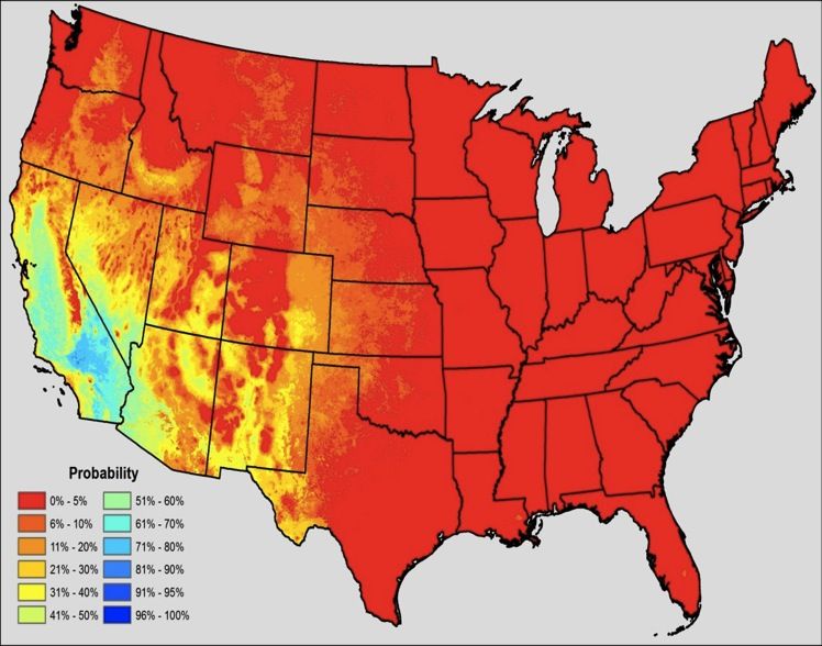
Ecosystem
Stress
and
Water
Use
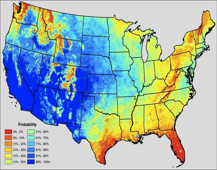
4 days = high probability of providing water consumption over US
Probabilities of producing valid estimates of water consumption over annual growing
periods of the lower 48-states using thermally-based energy balance when satellite
revisit time is 16 days (LEFT) and 4 days (RIGHT). Blue indicates high probability of
acquiring valid estimates. [Morton C, Huntington J and Allen R, 2012]"
Water Forum III: Droughts and Other Extreme Weather Events!
University of Texas -- 14 October 2013!
31
Next Steps and Questions
What are the operational requirements for drought and drought-related
applications?

• What are current barriers to satellite data use?
   • How can we develop a common language between missions/agencies/
     NGOs?
   • Interpretation of the data products/measurements into actionable info
   • Need to develop data format standards AND make it available to the
     public
   • How can we ensure involvement from private industry, state agencies,
     and universities;
       CUASHI, DEVELOP, SERVIR, NASA education and outreach
       programs?

     Goal: Identify partners to transition research to operations for both
           measurements and applications (operational capacity)

               Water Forum III: Droughts and Other Extreme Weather Events!
                         University of Texas -- 14 October 2013!             32
Questionnaire on use of NASA data for drought-related applications

                                 NASA Applied Sciences Questionnaire
                          Water Forum III: Droughts and Other Extreme Events

           What are the operational requirements for drought and drought-related applications?

           Do you currently use NASA data in your research/operations? If so, please name the
           data and comment on its availability, utility, and performance.

           What do you consider to be the biggest challenge to incorporating satellite data for
           improved operational capacity?

           How can we enhance and support involvement from private industry, state agencies,
           and universities in NASA Applications effort?

           Name and email (Optional): _________________________________________

               PLEASE RETURN FORM TO: mss@jpl.nasa.gov or john.bolten@nasa.gov

                       Water Forum III: Droughts and Other Extreme Weather Events
                                  University of Texas, 14 October 2013

            Water Forum III: Droughts and Other Extreme Weather Events!
                      University of Texas -- 14 October 2013!                                     33
Thank you

Water Forum III: Droughts and Other Extreme Weather Events!
          University of Texas -- 14 October 2013!             34
You can also read