Carrot River Watershed Source Water Protection Plan - March 2012
←
→
Page content transcription
If your browser does not render page correctly, please read the page content below
March 2012

Carrot River Watershed Source
Water Protection Plan


Table of Contents
1. Executive Summary .  .  .  .  .  .  .  .  .  .  .  .  .  .  .  .  .  .  .  .  .  .  .  .  .  .  .  .  .  .  .  .  .  .  .  .  .  .  .  .  .  .  .  .  .  .  .  .  .  .  .  .  .  .  .  .  .  .  .  .  .  .  .  .  .  .  . 5                        1
2. Introduction .  .  .  .  .  .  .  .  .  .  .  .  .  .  .  .  .  .  .  .  .  .  .  .  .  .  .  .  .  .  .  .  .  .  .  .  .  .  .  .  .  .  .  .  .  .  .  .  .  .  .  .  .  .  .  .  .  .  .  .  .  .  .  .  .  .  .  .  .  .  .  .  6             1
3. Process .  .  .  .  .  .  .  .  .  .  .  .  .  .  .  .  .  .  .  .  .  .  .  .  .  .  .  .  .  .  .  .  .  .  .  .  .  .  .  .  .  .  .  .  .  .  .  .  .  .  .  .  .  .  .  .  .  .  .  .  .  .  .  .  .  .  .  .  .  .  .  .  .  .  . 10         1
4. Mission Statement, Goal and Principles .  .  .  .  .  .  .  .  .  .  .  .  .  .  .  .  .  .  .  .  .  .  .  .  .  .  .  .  .  .  .  .  .  .  .  .  .  .  .  .  .  .  .  .  .  .  .  .  .  .  . 14                                                  1
5. Planning Objectives, Recommendations and Key Actions .  .  .  .  .  .  .  .  .  .  .  .  .  .  .  .  .  .  .  .  .  .  .  .  .  .  .  .  .  .  .  .  .  .  .  .  .  . 15                                                                           1
           5.1        Groundwater and Aquifer Protection .  .  .  .  .  .  .  .  .  .  .  .  .  .  .  .  .  .  .  .  .  .  .  .  .  .  .  .  .  .  .  .  .  .  .  .  .  .  .  .  .  .  .  .  .  .  .  .  .  . 16                                      1
           5.2        Communications and Education .  .  .  .  .  .  .  .  .  .  .  .  .  .  .  .  .  .  .  .  .  .  .  .  .  .  .  .  .  .  .  .  .  .  .  .  .  .  .  .  .  .  .  .  .  .  .  .  .  .  .  .  18                                     1
           5.3        Research .  .  .  .  .  .  .  .  .  .  .  .  .  .  .  .  .  .  .  .  .  .  .  .  .  .  .  .  .  .  .  .  .  .  .  .  .  .  .  .  .  .  .  .  .  .  .  .  .  .  .  .  .  .  .  .  .  .  .  .  .  .  .  .  .  .  .  .  . 21       1
           5.4 Water Conservation .  .  .  .  .  .  .  .  .  .  .  .  .  .  .  .  .  .  .  .  .  .  .  .  .  .  .  .  .  .  .  .  .  .  .  .  .  .  .  .  .  .  .  .  .  .  .  .  .  .  .  .  .  .  .  .  .  .  .  .  .  24                           1
           5.5 Water and Watershed Management .  .  .  .  .  .  .  .  .  .  .  .  .  .  .  .  .  .  .  .  .  .  .  .  .  .  .  .  .  .  .  .  .  .  .  .  .  .  .  .  .  .  .  .  .  .  .  .  .  27                                                   1
           5.6 Watershed Infrastructure and Engineering .  .  .  .  .  .  .  .  .  .  .  .  .  .  .  .  .  .  .  .  .  .  .  .  .  .  .  .  .  .  .  .  .  .  .  .  .  .  .  .  .  .  .  .  .  . 29                                                   1
           5.7        Watershed Stewardship .  .  .  .  .  .  .  .  .  .  .  .  .  .  .  .  .  .  .  .  .  .  .  .  .  .  .  .  .  .  .  .  .  .  .  .  .  .  .  .  .  .  .  .  .  .  .  .  .  .  .  .  .  .  .  .  .  .  32                          1
           5.8 Watershed Stressors .  .  .  .  .  .  .  .  .  .  .  .  .  .  .  .  .  .  .  .  .  .  .  .  .  .  .  .  .  .  .  .  .  .  .  .  .  .  .  .  .  .  .  .  .  .  .  .  .  .  .  .  .  .  .  .  .  .  .  .  39                             1
           5.9 Plan Implementation Strategy .  .  .  .  .  .  .  .  .  .  .  .  .  .  .  .  .  .  .  .  .  .  .  .  .  .  .  .  .  .  .  .  .  .  .  .  .  .  .  .  .  .  .  .  .  .  .  .  .  .  .  .  .  . 42                                       1
6. Conclusion .  .  .  .  .  .  .  .  .  .  .  .  .  .  .  .  .  .  .  .  .  .  .  .  .  .  .  .  .  .  .  .  .  .  .  .  .  .  .  .  .  .  .  .  .  .  .  .  .  .  .  .  .  .  .  .  .  .  .  .  .  .  .  .  .  .  .  .  .  .  .  .  44              1
      Bibliography  .  .  .  .  .  .  .  .  .  .  .  .  .  .  .  .  .  .  .  .  .  .  .  .  .  .  .  .  .  .  .  .  .  .  .  .  .  .  .  .  .  .  .  .  .  .  .  .  .  .  .  .  .  .  .  .  .  .  .  .  .  .  .  .  .  .  .  .  .  .  45              1

List of Figures
Figure 1 – Carrot River Watershed .  .  .  .  .  .  .  .  .  .  .  .  .  .  .  .  .  .  .  .  .  .  .  .  .  .  .  .  .  .  .  .  .  .  .  .  .  .  .  .  .  .  .  .  .  .  .  .  .  .  .  .  .  .  .  .  .  .  .  .  8                               1
Figure 2 – Planning Areas of Carrot River Watershed .  .  .  .  .  .  .  .  .  .  .  .  .  .  .  .  .  .  .  .  .  .  .  .  .  .  .  .  .  .  .  .  .  .  .  .  .  .  .  .  .  .  .  .  .  .  10                                                      1
Figure 3 – Groundwater (Idaho Museum of Natural History) . . . . . . . . . . . . . . . . . . . . . . . . . . . . . . . . . . . . . . . . . 16                                                                                                         1
Figure 4 – Average Daily Domestic Water Use (Environment Canada n.d.) .  .  .  .  .  .  .  .  .  .  .  .  .  .  .  .  .  .  .  .  .  .  .  .  .  .  .  .  .  .  .  .  24                                                                              1
Figure 5 – Typical Municipal Water Prices in Canada and Other Countries (Environment Canada n.d.) .  .  .  .  .  .  .  .  .  .  .  .  24                                                                                                              1

List of Tables
Table 1 – Carrot River Watershed State of the Watershed Report Card for Condition Indicators  .  .  .  .  .  .  .  .  .  .  .  .  .  .  .  .  .  .  . 9                                                                                               1

                                                                     Carrot River Watershed Source Water Protection Plan                                                                                                                          1
Message from the President, Saskatchewan Watershed Authority The Saskatchewan Watershed Authority is committed to watershed planning as an effective means to address risks to the province’s water supply, safety and ecosystems. I would like to congratulate the Watershed Authority staff, as well as the watershed advisory committees, technical advisory committee and board of the Carrot River Valley Watershed Association for developing the Carrot River Watershed - Source Water Protection Plan. This Plan, which represents considerable effort over the past three years, identifies priorities for tackling many of the challenging issues facing your watershed. Thank you as well to the dozens of volunteers who contributed hundreds of hours to the development of this Plan, for your work to date and for your ongoing efforts in watershed management as you move on to the implementation of the Plan. Water is essential for the health of our population, economy and ecosystems. As such, it is imperative and gratifying to realize a shared commitment by government, our communities and citizens toward ensuring a safe and sustainable water supply for the people of Saskatchewan. Wayne Dybvig, President Saskatchewan Watershed Authority 2 Carrot River Watershed Source Water Protection Plan
Message from the
Carrot River Valley Watershed Association
The mission of the Carrot River Valley Watershed Association is to protect and improve water quantity and
the health of our watershed, through collaborative planning and facilitating partnerships. The Association is
also dedicated to preserving the beauty, diversity, and integrity of the watershed by raising awareness and
understanding of watershed issues and promoting sustainable environmental, economic and cultural activities.
On behalf of the members of the Carrot River Watershed advisory committees, we are pleased to provide the
Source Water Protection Plan for Carrot River Watershed. This document is the result of a planning process
that began in December 2008 and incorporated over three years of involvement with local volunteers. The Plan
contains a series of objectives, recommendations and key actions, created to protect both surface and ground
water supplies and address infrastructure issues. Key actions were designed to provide a clear direction of what
needs to be done, and by whom. The result of these actions will meet the challenges of today and tomorrow,
helping to ensure clean water supplies for the future.
We wish to thank the members of the technical committee, who greatly assisted the watershed advisory
committees throughout the development of the Source Water Protection Plan.
The Plan was completed under the leadership of the Saskatchewan Watershed Authority, through consultation
with local watershed advisory committees. The Committees’ broad membership included representatives from
urban and Rural Municipalities, industry, conservation organizations, Agri-Environmental Group Plan (AEGP)
committee, and First Nations.
Many have joined our positive approach to incorporating best management practices in both the urban and
rural landscapes of our communities in the Carrot River Watershed. Our Association imagines the positive
future we all wish to see: healthy families, parks and open spaces with abundant wildlife, clean drinking water,
and good jobs. As we work towards these goals, we believe it is important to reassess both our environmental
management systems and the value systems that underlie them.
Through actions aimed at educating the public about environmental and watershed health issues, stewardship
initiatives on private lands and enhancement work that will improve the water quality of creeks and streams, you
can be part of the watershed’s future. Landowners are encouraged to maintain, enhance and protect existing
natural features and consider the ecological health of natural systems in their land use activities.
I deeply appreciate the efforts that have gone into completion of the Carrot River Source Water Protection Plan.
I look forward to implementation of the plan with the support of local communities and residents.

Garfield Hnatiuk, Chairperson
Carrot River Valley Watershed Association

                               Carrot River Watershed Source Water Protection Plan                                 3
1. Executive Summary
The Province of Saskatchewan needs to ensure that it has an adequate supply of high quality water for the
future. Under the Long-Term Safe Drinking Water Strategy, source water protection planning began in 2003 for
at-risk watersheds in the populated areas of the province.
In the fall of 2008, Watershed Authority planners approached stakeholders in the Carrot River Watershed
to participate in source water protection planning. Watershed advisory committees, which were assembled
from volunteers, began planning meetings in December 2008. A technical committee was established with
advisors from the Watershed Authority and partner agencies including Saskatchewan Ministry of Environment,
Saskatchewan Ministry of Agriculture and Ducks Unlimited Canada.
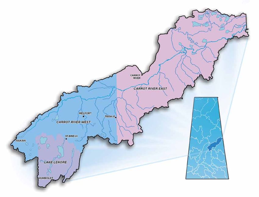
The Carrot River Watershed is a relatively large geographic area. As such, watershed advisory committee
members were divided into three "sub-watershed" advisory committees for planning purposes: Carrot River
East, Carrot River West and Lenore Lake.
Watershed advisory committee members discussed the challenges and opportunities surrounding source water
protection for the watershed. The goal of the process was to develop planning objectives, recommendations
and key actions as the foundation of a source water protection plan. The Carrot River Watershed Source
Water Protection Plan (Plan) is the product of subsequent planning efforts which involved representatives of rural
and urban municipalities, First Nations, conservation groups and local Conservation and Development
Area Authorities.
The Plan’s objectives, recommendations and key actions have been developed by the members of the
watershed advisory committees in collaboration with the technical committee. This content has been reviewed
by subject experts from the technical committee. The watershed advisory committees have identified high,
medium and low priority items to assist in the implementation of the plan.
Watershed residents were consulted through a series of open houses. Their comments were provided to the
watershed advisory committees for consideration. Comments were also received from the provincial and federal
government agencies, as well as stewardship organizations, which made up the technical committee and will
support implementation of the Plan. These comments were reviewed through a joint meeting of the technical
committee and watershed advisory committees.
The core of the Plan is its objectives, recommendations and key actions. These are grouped into eight
categories: Groundwater and Aquifer Protection, Communications and Education, Research, Water
Conservation, Water and Watershed Management, Watershed Infrastructure and Engineering, Watershed
Stewardship and Watershed Stressors.
The Carrot River Valley Watershed Association has been established to lead implementation of the Plan.
This non-profit group includes representatives of the local governments and organizations that made up the
watershed advisory committees. The Carrot River Valley Watershed Association will work with the partner
agencies and local stakeholders for implementation of the Source Water Protection Plan.
Carrot River Watershed Source Water Protection Plan 52. Introduction
Water is a fundamental component of any sustainable community. Safe drinking water, support for agriculture
and industry, habitat, hydropower generation and recreation are ensured by managing and protecting this vital
resource. This is a major contribution to ensuring a safe and prosperous Saskatchewan.
The protection of water quality is a critical aspect of water management. The quality of water can be influenced
by a number of natural and human factors. Natural factors include climate and topography. Human factors
include agricultural runoff and wastewater discharges (CCME 2004, 64). These and many other potential sources
of contamination underscore the need to properly manage and protect Saskatchewan’s water resources.
The 2001 Cryptosporidium parvum outbreak in North Battleford, Saskatchewan is an example that illustrates the
need for water management and protection. Between March and April 2001, an estimated 5,800 to 7,100 people
became ill after Cryptosporidium parvum entered the city’s water treatment plant (Laing 2002, 4). In response
to this event the Government of Saskatchewan ordered the Commission of Inquiry into the safety of the public
drinking water in North Battleford (Laing 2002). Commissioner Justice Robert Laing recommended 28 actions to
improve the safety of the province’s drinking water. The Long-Term Safe Drinking Water Strategy (Strategy) was
developed in response to the needs identified by the North Battleford Water Inquiry (Saskatchewan 2002).
The Strategy is a comprehensive action plan designed to address the risks that affect drinking water. It
establishes a vision for “a sustainable, reliable, safe and clean supply of drinking water that is valued by the
citizens of Saskatchewan” (Saskatchewan 2002). In order to achieve this vision, the Strategy employs the
multi-barrier approach, which is widely accepted as the most effective method to protect drinking water
(Saskatchewan 2002, 5). The Canadian Council of Ministers of the Environment (CCME) defines the multi-barrier
approach as “an integrated system that prevents or reduces the contamination of drinking water, from source
to tap, in order to reduce risks to public health” (CCME 2002, 4). This approach establishes barriers along the
water supply route to prevent or reduce potential contaminants from reaching the end user.
The three barriers identified in the Strategy are:
• source protection;
• water treatment and operation; and
• water monitoring and testing.
Although the multi-barrier approach is a comprehensive method to ensure safe drinking water, the CCME
stresses the fact that “individually, the barriers may be inadequate in removing or preventing contamination
of drinking water” (CCME 2002, 5). Greater assurance of safe drinking water only occurs when all barriers are
used together.
As the first step in the multi-barrier approach, source water protection is an essential component of any strategy
to minimize contamination risks in a drinking water system (CCME 2002, 9). The Strategy identifies the following
as the essential components of a source water protection plan (Saskatchewan 2002, 3):
• an inventory and characterization of the water source;
• an up-to-date inventory of all sources of pollution affecting the water source;
• the type of pollutants being discharged into each watershed must be quantified; and
• goals and strategies for protecting, monitoring and evaluating each watershed must be developed.
6 Carrot River Watershed Source Water Protection PlanThe goals and strategies, which form the basis of source water protection, must consider both short and long-
term actions to control non-point1 and point2 sources of pollution over time. The Strategy also establishes
source water protection goals and objectives for the Province of Saskatchewan. The goal is “to protect source
waters now and into future” (Saskatchewan 2002, 2). The objectives are to ensure “risks to source water quality
are known” and “watersheds are protected, natural purification and protection processes are maximized and
potential for contamination is minimized” (Saskatchewan 2002, 2).
As a key action established in the Strategy, in 2002 the provincial government created the Watershed
Authority to manage and protect water quantity and source water quality in Saskatchewan. In order to meet
its mandate, the Watershed Authority released Protecting our Water: a Watershed and Aquifer Planning Model
for Saskatchewan (Model) to the public in 2003. This document provided the Watershed Authority with the
framework to establish watershed and aquifer plans in the province.
Watershed and aquifer planning is an essential part of implementing the source water protection goals and
objectives set out in the Strategy. In addition to delivering source water protection in the strict sense, the
Model is designed to address related concerns about water management, the quality and quantity of the water
resources, demand for water, flooding and drought, climate change, the protection of riparian3 and wetland
areas, and maintaining biodiversity.
Watershed planning is a collaborative effort among government, non-government agencies and local
stakeholders. The planning process identifies and explores threats to source water quantity and quality
while providing a forum for stakeholders to participate in developing a strategy that contributes to sound
water management.
The management and protection of the water resources for the benefit of Saskatchewan residents is best served
when stakeholders collaborate frankly and with mutual respect, then commit to actions that support common
goals. Involving local stakeholders in plan development ensures that vital local knowledge is incorporated. This
involvement establishes local support and ownership of the plan.
The watershed planning process also relies on the expertise of natural resource managers from various
government and non-government agencies. These experts assemble information in order to target areas of
concern, inform discussion among partner agencies and stakeholder representatives, and present options to
address issues.
Regardless of the scope, the Model is designed to achieve consensus, collaboration and stakeholder
involvement throughout the process. With a focus on protecting the quantity and quality of water supplies,
the planning process is designed to identify threats and initiate opportunities to address them.
1 Non-point source pollution - Non-point source pollution, unlike pollution from industrial and sewage treatment plants, comes from many diffuse sources. Non-
point source pollution is caused by rainfall or snowmelt moving over and through the ground. As the runoff moves, it picks up and carries away natural and
human-made pollutants, finally depositing them into lakes, rivers, wetlands, coastal waters and groundwaters (U.S. Environmental Protection Agency 2011).
2 Point source pollution - Pollution discharged through a pipe or some other discrete source from municipal water treatment plants, factories, confined animal
feedlots, or combined sewers (United States Geological Survey 2011).
3 Riparian area - An area of land directly influenced by water. An ecosystem that is transitional between land and water ecosystems. Riparian areas usually
have visible vegetative or physical characteristics reflecting the influence of water. River sides, lake borders, and marshes are typical riparian areas
(www.biology-online.org 2005).
Carrot River Watershed Source Water Protection Plan 7The Carrot River Watershed
The Carrot River Watershed, located in both Saskatchewan and Manitoba, covers an area of approximately
17,500 square kilometres (See Figure 1). Nearly 15,750 square kilometres of the watershed are situated
in Saskatchewan. The scope of this Plan is limited to the portion of the Watershed located in the Province
of Saskatchewan.
Figure 1 – Carrot River Watershed
The Carrot River is the dominant watercourse in this watershed. The river’s
headwaters originate in the Cudworth and Tiger Hills Plains near the Town of
Wakaw. The outlet of Wakaw Lake marks the start of the Carrot River. From
there, the river flows northeast through the Melfort and Red Earth Plains
until it empties into the Saskatchewan River west of The Pas, Manitoba.
The river’s total length is approximately 300 kilometres. The Carrot River
parallels the course of the South Saskatchewan and Saskatchewan Rivers.
The distance between these rivers never exceeds 50 kilometres, while
Waldsea Lake flooding from July 2010 tour the width of the Carrot River Watershed never exceeds 80 kilometres
with speaker Murray Suchan, (SaskWater 1994, 3). The Pasquia Hills form the southeastern border of the
Saskatchewan Watershed Authority watershed and contribute a substantial amount of water to the Carrot River.
8 Carrot River Watershed Source Water Protection PlanTributaries that flow northward towards the Carrot River include Coldwell
Creek, McCloy Creek, Dead River, Goosehunting Creek, Melfort Creek,
Sweetwater Creek, Leather River, Presbyterian River, Doghide River,
Crooked River, Burntout Brook, Jordan River, Papikwan River, Cracking
River, Man River and Rice River. Tributaries north of the Carrot River include
Sandhill Creek, Little Bridge Creek, and Emmons Creek.
The Lenore Lake internal drainage basin is within the Carrot River
Watershed. The Lenore Lake Basin is characterized by moderately
rolling to hilly terrain. The unique topography of the basin has developed
St. Brieux Regional Park.
Credit: St. Brieux Realty several saline water bodies such as the Lenore, Basin, Houghton, Middle,
Deadmoose, Waldsea and Ranch lakes. Both Waldsea and Basin are
terminal lakes, with Waldsea receiving water from Deadmoose while Basin receives water from Middle Lake
during wet periods. All the lakes within the basin are saline with the exception of St. Brieux and Burton lakes.
The watershed climate is classified as dry sub-humid and is characterized by cool summers, cold winters,
and moderate precipitation (SaskWater 1994, 3). Consistent with the Prairie climate, the amount of precipitation
varies widely from year to year. The area’s average annual precipitation ranges from approximately
400 millimetres in the west to nearly 500 millimetres in the east (SaskWater 1994, 3).
The Carrot River Watershed includes the City of Melfort, seven towns, 11 villages, 21 Rural Municipalities
and six First Nation Reserves. The total population of the watershed is estimated at 25,500 (Statistics Canada
n.d.). Approximately 13,500 inhabitants are classified as rural residents, while roughly 12,000 residents live in
the watershed’s urban centres. The majority of the population is concentrated in the south central portions of
the watershed.
The State of the Watershed Report is used to provide an overall indication of the health of a specific watershed
in Saskatchewan. The reporting process is based on a Stress-Condition-Response model, which uses
indicator-based assessments to rate watershed health, environmental stressors, and management responses.
This Model explicitly recognizes relationships between the health of the watershed (condition), human impacts
on the ecosystem (stressors) and the associated management activities (responses) that have been adopted to
mitigate stresses and improve the health of the watershed.
The Carrot River Watershed, as determined by the 2010 State of the Watershed, is classified as “Stressed.”
This means that while the functions and services it provides have not declined or deteriorated, the watershed
has lost its resistance to change. As shown in Table 1, four of six conditions are rated as stressed. These include
surface and ground water quality, riparian areas and rangeland health.
Table 1 – Carrot River Watershed State of the Watershed Report Card for Condition Indictors
Condition Status
Surface Water Quality Stressed
Groundwater Quality Stressed
Aquatic Benthic Macroinvertebrate Healthy
Riparian Areas Stressed
Rangeland Health Stressed
Environmental Acidification Healthy
Health Grade Stressed
Carrot River Watershed Source Water Protection Plan 93. Process
As previously noted, source water protection in Saskatchewan is based on collaboration between
government and local stakeholders in a consensus-based process. The Watershed Authority partnered with local
community and technical stakeholders to develop a source water protection plan for the Carrot River Watershed.
Assembly of Teams
The watershed and aquifer planning model requires formation of watershed advisory committees, a technical
committee and a planning team to:
• identify interests and issues of concern;
• assemble technical content; and
• facilitate and guide plan development.
Watershed advisory committees included local representatives from rural and urban municipalities, First Nations,
Conservation and development area authorities, wildlife federations, resort villages and regional parks.
Committee members represented the interests and issues of their organizations, while working through a
consensus-based approach to develop a common understanding of the watershed.
DRAFT Carrot River Watershed
R.M. Number R.M. Name First Nation Reserve Number First Nation Name
No. 369 R.M. of St. Peter IR #100 James Smith First Nation
No. 370 R.M. of Humboldt IR #100A Cumberland First Nation
No. 394 R.M. of Hudson Bay IR #91 Kinistin First Nation
T56
No. 397 R.M. of Barrier Valley IR #29 & 29A Red Earth First Nation
No. 398 R.M. of Pleasantdale IR #28A Shoal Lake First Nation
No. 399 R.M. of Lake Lenore IR #27A The Pas First Nation
No. 400 R.M. of Three Lakes IR #20 Cumberland House First Nation
No. 401 R.M. of Hoodoo
No. 402 R.M. of Fish Creek
No. 426 R.M. of Bjorkdale
T53 No. 427 R.M. of Tisdale
No. 428 R.M. of Star City
T52
No. 429 R.M. of Flett’s Springs
No. 430 R.M. of Invergordon
T51
No. 431 R.M. of St. Louis
T50 No. 456 R.M. of Arborfield
No. 457 R.M. of Connaught
T49 No. 458 R.M. of Willow Creek
No. 459 R.M. of Kinistino
T48
No. 486 R.M. of Moose Range
T47 No. 487 R.M. of Nipawin
T46
T45
T44
T43
T43A Map Produced By:
Saskatchewan Watershed Authority, Geomatics Unit
© 2009, Government of Saskatchewan
T42
Date: January 29, 2009
Project Folder #: 20080722 01
T41
File Name: Overall_Basin_10_8x11.mxd
Disclaimer: SWA prepares maps with varying
T40 degrees of accuracy and completeness dependant
on the circumstances and available data. SWA
makes no representation that this map will be
T39 sufficient for all uses. The user is advised to confirm
the information contained herein in the event that
T38 precision and currency of data are required.
Projected Coordinate System:
NAD 1983 CSRS98 UTM ZONE 13N
T37
T36
T35 R01 R28 R27 R26 R25 R24 R23 R22 R21 R20 R19 R18 R17 R16 R15 R14 R13 R12 R11 R10 R09 R08 R07 R06 R05 R04 R03 R02 R01 R32 R31 R30
Figure 2 – Planning Areas of Carrot River Watershed 0 12.5 25 50 75
Kilometres
100
10 Carrot River Watershed Source Water Protection PlanEach of the watershed advisory committees developed a terms of reference during the initial meetings.
These included information to address the rules of committee operation and the consensus-based
decision-making process.
The Carrot River Watershed is a relatively large geographic area. To ensure reasonable travel times for the
watershed advisory committee volunteer members, the watershed was divided into three “sub-watershed”
planning areas: Carrot River East, Carrot River West and Lenore Lake (see Figure 2).
The technical committee included representatives from agencies with expertise in natural resources
management. Various divisions of the Watershed Authority provided staff, including surface and ground water
specialists. External agencies included:
• Agriculture and Agri-Food Canada
Agri-Environment Services Branch;
• Ducks Unlimited Canada;
• Fisheries and Oceans Canada;
• Provincial Council of Agriculture
Development and Diversification
Boards for Saskatchewan;
• Saskatchewan Ministry of Agriculture;
• Saskatchewan Ministry of Environment;
• Saskatchewan Ministry of
Municipal Affairs; and Carrot River East Watershed Advisory Committee Meeting. Left to Right: Gary Jones,
• Weyerhaeuser Canada Ltd. Lynne Roszell, Alvin Alyea, John Daisley, Brian Campbell and Wilfred Trites
The role of the technical committee was to support the watershed advisory committees by providing expert
knowledge, relevant research and responses to specific information requests from the committee.
The planning team consisted of staff from Watershed Planning and Lands Management Branch. Key
responsibilities of the planning team included establishing and managing the watershed advisory and technical
committees, compiling background information, managing the public consultation process and developing the
plan. The team guided participants in round table discussions to determine issues and set priorities. Group
validation of and commitment to sound watershed management was encouraged. Each watershed advisory
committee selected a chairperson as the main point of contact between the committee and the planning team.
In September 2008, the planning process began with a series of open houses. Potential watershed advisory
committee members were invited to attend an open house, learn about watershed planning and discuss
their interests and issues. A media release was also issued at this time to inform the public about the
planning process.
Carrot River Watershed Source Water Protection Plan 11Discussion of Interests and Issues
The next phase of the planning process began in December 2008 with the definition of interests and issues.
Various interests and issues were discussed by the watershed advisory committees. Presentations by technical
agency representatives served to guide the discussions, with relevant interests and issues discussed at the
conclusion of each presentation.
All three watershed advisory committees received the following presentations:
• Agri-Environmental Group Plans;
• Aquatic Ecosystem Health of Carrot River;
• Carrot River Watershed Groundwater Overview;
• Hydrology of the Carrot River Basin;
• In-stream Flow Needs;
• Organization and Operation of the Assiniboine Watershed Stewards Association;
• Overview of Drainage Legislation and Policy;
• Protection of Drinking Water and Management of Wastewater;
• Riparian Area Characteristics and Benefits;
• Role and Responsibilities of Fisheries and Oceans Canada;
• Role of Regional Operations in Carrot River Watershed;
• State of the Watershed Report for Carrot River;
• Watershed Protection during Forest Operations; and
• Wetland Retention and Water Quality.
Once all presentations were completed, each of the three watershed advisory committees drafted an interests
and issues list. After review by the watershed advisory committees, the identified interests and issues were
provided to technical committee members. In September 2010, the final interests and issues list was completed.
Technical committee members then worked with the planning team to prepare a background report. Relevant
data was included to assist stakeholders in understanding the watershed and support decision-making.
Information included population and demographic details, economic activities and land use, climate, physical
and topographic characteristics including soils, surface and ground water availability, water allocations, trends
in water use and wastewater disposal and treatment. The background report also focused on the ecology of
the watershed, with an emphasis on ecological diversity, indicators of riparian health and ecologically sensitive
areas. Following review at a technical committee meeting, the background data was distributed to watershed
advisory committee members.
Touring the watershed and discussing the situation on site provided additional information and a different
perspective. Two watershed tours, which were open to all watershed advisory committee and technical
committee members, were held in July 2010. Attendees travelled to significant facilities, such as water and
wastewater treatment systems, viewed demonstrations of beneficial agricultural management practices and
visited sites with specific water management issues like flooding and erosion.
Other techniques were adopted to inform watershed residents about the process. Information about Carrot
River Watershed planning, including meeting notes and presentations, was made available online. A Carrot
River Watershed newsletter was sent to all watershed residents during the finalization of the interests and issues
phase. This newsletter identified the importance of watershed planning, discussed the planning approach,
highlighted the significant interests and issues in the watershed and invited public comment.
12 Carrot River Watershed Source Water Protection PlanDrafting of the Plan
A final list of interests and issues was prepared in September 2010. As each sub-watershed advisory committee
brought forward approximately 20 separate interests and issues, the planning team recognized that the
committees would not be able to complete the entire process in a reasonable length of time. In June 2011,
each committee prioritized its ten most important issues to be included in the Plan.
Technical committee members developed information in their areas of expertise, with the assistance of
the planning team. The planning team used this technical information to create planning worksheets for
each issue. The worksheets were then used by the watershed advisory committees to establish objectives,
recommendations, key actions, potential partner agencies and timelines that addressed the issues.
The draft worksheets were reviewed by the technical committee, which provided feedback and comment.
In December 2011, a joint meeting of the watershed advisory and technical committees was held to review the
comments and revise the objectives, recommendations, key actions, responsible agencies and timelines for the
draft Plan. The objectives, recommendations and key actions were then prioritized as low, medium or high.
This marked the completion of the draft source water protection plan.
Implementation Agency Development
To reduce the potential lag time between the end of the planning process and the beginning of Plan
implementation, the first steps toward implementation were taken before the planning process ended.
Preparation of the draft plan and the initial stages of implementation occurred concurrently.
In July 2011, approximately six months before the draft plan was completed, a steering committee was
established to direct the formation of a non-profit stewardship group to implement the plan. The steering
committee, which was composed of two to three committee members from each watershed advisory committee,
met regularly for six months to direct the incorporation process, develop by-laws and establish the membership
requirements of the stewardship group.
The steering committee incorporated the stewardship group as the Carrot River Valley Watershed Association
Inc. The Association then entered into a contribution agreement with the Authority to provide core funding.
The Association then advertised for an Executive Director to supervise implementation of the plan.
The next step in the process was the election of a permanent Board of Directors for the Carrot River Valley
Watershed Association.
Review of the Plan
Once the draft Plan was completed, it was then taken to the public for comment through a series of open
houses in watershed communities. During January 2012, seven open houses were held in five locations.
Public comments were recorded and provided to the watershed stewardship group for consideration.
The draft source water protection plan was also distributed to the agencies involved with the technical
committee for review and comment. Other agencies, which were identified as potential partners to assist with
plan implementation, were also asked to provide comments.
A joint meeting of the watershed advisory and technical committees was held in February 2012 to review all
comments and determine the final objectives, recommendations, key actions, partner agencies and timelines.
Carrot River Watershed Source Water Protection Plan 134. Mission Statement, Goal and Principles
During the initial watershed advisory committee meetings in 2009, the planning team worked with the watershed
advisory committees to develop the following mission statement, goal and principles for the planning process.
Mission Statement
The watershed advisory committees and technical committee will work co-operatively to provide accurate
information, describe issues of concern, protect source waters and recommend solutions for implementation of
the Source Water Protection Plan.
Goal
The watershed advisory committees will participate in the development and recommend implementation of
a Source Water Protection Plan that will provide for watershed protection and help sustain water quality and
quantity in an integrated and environmentally sound manner.
Principles for Watershed Planning
The watershed advisory committees will develop a Source Water Protection Plan that will:
• Promote the needs and wishes of the people and communities within the watershed planning area, and in
general, the people of Saskatchewan, on watershed protection issues.
• Incorporate integrated resource management by linking water quality and quantity and the management of
other resources, recognizing hydrological, ecological, social and institutional systems.
• Promote water conservation and the protection of water quality by recognizing the value and limits of
water resources and acknowledging both consumptive and non-consumptive values.
• Resolve water management issues through the Adaptive Resource Management model, monitoring
and consultation.
• Seek beneficial management practices and stewardship actions that will improve source water.
• Ensure accountability through open communication, education and public access to information.
• Respect the rights of First Nations and Métis communities, municipalities, interest groups and the public.
• Consider the values and interests of First Nations and Métis communities, municipalities and other
participants when making management recommendations.
• Recognize the authority and responsibilities of the irrigation districts, watershed associations, conservation
area associations, municipalities, non-government organizations, provincial government ministries,
provincial Crown corporations, federal government departments and First Nations and Métis that are
involved with the planning process.
• Recognize and be consistent with current legislation and policies, and recommend changes
where appropriate.
• Be flexible and adapt to new circumstances and information.
• Be subject to review and consideration by the non-government organizations, irrigation districts,
watershed associations, conservation area associations, municipalities, provincial government ministries,
provincial Crown corporations, federal government departments and First Nations and Métis that have
been identified as responsible for aspects of plan implementation, on a regular basis.
14 Carrot River Watershed Source Water Protection Plan5. Planning Objectives, Recommendations and Key Actions
Within the planning process, water management interests and issues such as drainage concerns typically
dominate the initial committee discussions. The quality and quantity of the water resources in contrast to the
demands that are placed on the resource, flooding and drought, climate change and the protection of riparian
areas are issues that regularly come to the fore. Validating and prioritizing these issues are important outcomes
of this step in the process (Watershed Authority 2003).
Objectives
Planning objectives were developed after discussion and prioritization of the issues in the watershed. Objectives
can range from activities to provide watershed residents with an improved understanding of the quality and
quantity of the water resources and related ecological components to an assessment of a specific issue that is of
particular interest or concern to stakeholders. Taking steps to improve water supply and source water quality are
the type of specific objectives which could be pursued in a watershed or aquifer plan.
The assembly and analysis of information to address planning objectives is typically undertaken by the technical
committee. The type of information gathered and degree of analysis conducted depends on the issues. In
many cases, the analysis involves evaluating a range of options to address the planning objective. The analysis
provides the basis for activities to address watershed issues and concerns. For example, an objective of
addressing threats to groundwater can result in identifying best management practices to deal with those risks.
Recommendations and Key Actions
The concluding section of the Source Water Protection Plan summarizes the outcomes of the committee
discussions and technical analysis. Responses to the planning objectives are usually presented through a series
of recommendations, along with a general discussion of the perspectives of watershed residents. Because
actions to implement the recommendations are critical to the acceptance and ultimate success of the plan, a
clear indication of what needs to be undertaken, and by whom, is needed.
Carrot River Watershed Source Water Protection Plan 155.1 Groundwater and Aquifer Protection
The discussions of the watershed advisory committees during the process identified aquifer and groundwater
protection as significant issues. This section provides a basic background about aquifer and groundwater
protection along with the objective, recommendations and key actions to address these issues.
Groundwater Figure 3 – Groundwater
Groundwater is an (Idaho Museum of Natural History)
important part of the
earth’s water cycle.
Water continuously
circulates between land,
air and ocean in the
form of rain, snow, water
vapour, surface water
and groundwater (See
Figure 3). Groundwater
starts off as surface
water or precipitation
and enters the ground
through areas generally
referred to as recharge
areas (Mauce 2008).
Aquifers
Aquifers are rock or soil that is completely saturated with water (Mauce 2008). Aquifers are formations from
which water can be removed economically. Although water moves through an aquifer, it is not an underground
river. Typically, aquifers are made up of sediments with relatively large and connected pore spaces that permit
water movement. Aquifers are most commonly composed of sands and gravels, but in some areas may be
formed by cracked or fractured coal or shale.
Groundwater Quality in Saskatchewan
Groundwater is an important source of domestic and
drinking water in rural Saskatchewan. Groundwater
supplies in Saskatchewan are highly mineralized, and can
include sulphate, sodium, chloride, calcium, magnesium,
bicarbonate and carbonate.
The quantity of dissolved minerals and the type of ions
dissolved in the water are primarily dependent on the type
of rock and soil that the water comes into contact with
as it infiltrates the soil (Mauce 2008). Groundwater quality
in Saskatchewan is quite variable but, in general, deep
aquifers tend to have higher total dissolved solid levels than
shallow aquifers. Shallow aquifers are more susceptible to
contamination from local land use activities, and can be
vulnerable to nitrate and microbial contamination.
Abandoned Water Well Decommission Workshop
October 2010, Yellow Creek
16 Carrot River Watershed Source Water Protection PlanUnfortunately, most groundwater supplies in Saskatchewan do not meet Canadian Drinking Water Quality
Guidelines (Mauce 2008). Most commonly, they exceed guidelines for aesthetic parameters, such as total
dissolved solids, hardness, and levels of iron and manganese. The frequency in which the water from domestic
wells exceeds health-related parameters, such as bacteria, nitrate, arsenic, selenium and uranium, is of greater
concern. Some studies have shown that up to 99% of domestic wells sampled exceeded a health or aesthetic
parameter, and 35% or more exceeded one or more health parameters. Despite the relatively poor quality of
groundwater, the water can be treated to meet a satisfactory quality level in most cases. This makes it very
important for well owners to test their water supplies regularly, identify any quality issues and either take
appropriate treatment actions to make the water safe for its intended use or locate an alternate water source.
Several communities in the Carrot River Watershed, including the towns of Carrot River and Tisdale, rely on
groundwater for their drinking water. In the rural areas, many residents also use groundwater to supply their
household and agricultural needs. The watershed advisory committees identified concerns about possible
threats to groundwater from surface contamination and developed the following objectives, recommendations
and key actions.
Planning Objective
Promote measures for groundwater protection in the Carrot River Watershed.
Recommendations
• Increase awareness and education surrounding abandoned water well decommissioning in partnership
with the Carrot River Watershed Agri-Environmental Group Plan.
• Deliver abandoned water well decommissioning and well head protection programs, working with rural and
urban municipalities, First Nations and other partners.
Key Actions
1. Deliver abandoned water well decommissioning workshops in the watershed area.
2. Work with the Carrot River Watershed Agri-Environmental Group to assist farmers in applying for
cost-shared funding to decommission abandoned water wells through the Canada-Saskatchewan
Farm Stewardship Program.
3. Seek funding to decommission all abandoned water wells and to protect active water wells for
communities and for residents who are not eligible for the Canada-Saskatchewan Farm
Stewardship Program.
4. Identify abandoned water wells to decommission in areas that rely on groundwater as the primary or
secondary water source and communicate this information to the Watershed Authority.
5. Record and track the number and location of decommissioned water wells within the watershed. When
applicable, utilize the Authority’s groundwater database to provide decommissioned water well locations
to the Authority.
Lead Responsibility Time Frame Priority
Partners
• Carrot River Valley Watershed Association (co-lead) 2012 and ongoing High
• Carrot River Watershed Agri-Environmental
Group Plan (co-lead)
• Saskatchewan Watershed Authority
• Saskatchewan Ministry of Environment
Carrot River Watershed Source Water Protection Plan 175.2 Communications and Education
People often take good quality, abundant water for granted. They do not always understand how their actions
can alter water quality and quantity, or how stewardship and improved land-use practices can improve their
water. Encouraging the public to change behaviours and promoting environmental sustainability are important
steps in source water protection.
The watershed advisory committees brought forward several objectives on communications and education.
A key priority was the development of a communications strategy where success could be measured and
monitored. One of the communication objectives was to promote water quality testing for both water wells
and dugouts. As noted in the preceding section (Aquifer and Groundwater Protection), a majority of wells in
Saskatchewan exceed one or more health or aesthetic standards.
During advisory committee discussions, concern was raised about the process and costs of meeting fish habitat
protection requirements for construction and replacement of infrastructure such as culverts. An objective was
established to improve communications between Fisheries and Oceans Canada, the Saskatchewan Ministry of
Environment, municipalities and local residents.
Planning Objective
Develop a communications strategy, which will serve to establish, and then track agency profile, key watershed
issues, and programming success.
Recommendation
Develop a communications strategy with measureable success as a priority. Focus the strategy on the planning
objectives, recommendations and key actions in the Source Water Protection Plan.
Key Actions
6. Develop a communications strategy for the Carrot River Valley Watershed Association within the first year
of operation, and ensure the following principles are incorporated:
• objectives;
• messaging;
• audiences;
• tools and activities;
• resources and timescales; and
• metrics for evaluation and revision.
7. Implement the communications strategy during the first year of operation and monitor for three years.
8. Use appropriate metrics such as surveys, media coverage, volunteer hours and in-kind support to gauge
effectiveness, programming successes, and agency profile within the watershed.
9. Revise the strategy after the third year of implementation to ensure it remains effective and relevant.
10. Communicate the planning objectives, recommendations and key actions of the Carrot River Watershed
Source Water Protection Plan through the communications strategy.
Lead Responsibility Time Frame Priority
Partners
• Carrot River Valley Watershed Association 2012 and ongoing High
18 Carrot River Watershed Source Water Protection PlanPlanning Objective
Promote water quality testing for water supplies including active water wells and dugouts in the Carrot River
Watershed to protect human health, livestock, and aquifers.
Recommendation
Seek partnerships with agencies such as the Watershed Authority and the Saskatchewan Ministry of
Environment to encourage water quality testing for water supplies including water wells and dugouts in the
Carrot River Watershed.
Key Actions
11. Promote water quality testing for active water wells and dugouts by developing newsletter articles and
including links to educational materials on the Saskatchewan Ministry of Environment and Watershed
Authority websites.
12. Indicate Association support for the Rural Water Quality Advisory program administered by the Watershed
Authority.
Lead Responsibility Time Frame Priority
Partners
• Carrot River Valley Watershed Association 2012 and ongoing High
• Carrot River Watershed Agri-Environmental Group Plan
• Saskatchewan Watershed Authority
• Saskatchewan Ministry of Environment
Carrot River Watershed Source Water Protection Plan 19Planning Objective
Improve communication about the protection of fish habitat and shoreline alteration legislation among Fisheries
and Oceans Canada, the Saskatchewan Ministry of Environment, local municipalities and watershed residents.
Recommendations
• Provide information to local municipalities and watershed residents on the policies, legislation and
standards of Fisheries and Oceans Canada and the Saskatchewan Ministry of Environment relating to fish
habitat and shoreline alteration.
• Provide information to local communities on obtaining environmental approvals and licences from
regulatory agencies.
Key Actions
13. Encourage Fisheries and Oceans Canada and the Saskatchewan Ministry of Environment to provide
information on their policies, legislation and standards through public education programs and workshops
with local municipalities.
14. Assist Fisheries and Oceans Canada and the Saskatchewan Ministry of Environment to inform local
municipalities and watershed residents about requirements for protection of fish habitat.
15. Work with Fisheries and Oceans Canada to deliver seminars and disseminate information on Fisheries
and Oceans Canada’s operational statements, policy and legislation to local municipalities and
Conservation and development area authorities.
16. Act as a local municipality resource and liaison for inquiries regarding approvals and licences from
Fisheries and Oceans Canada, Environment Canada, Saskatchewan Ministry of Environment, and the
Watershed Authority.
Lead Responsibility Time Frame Priority
Partners
• Carrot River Valley Watershed Association Ongoing Medium
• Fisheries and Oceans Canada
• Environment Canada
• Saskatchewan Ministry of Environment
• Saskatchewan Watershed Authority
• Provincial Association of Recreational
Communities of Saskatchewan
• Rural and urban municipalities
• Conservation and development area authorities
20 Carrot River Watershed Source Water Protection Plan5.3 Research
The success of a source water protection plan is often related
to the baseline information that is accessible on the particular
watershed. The watershed advisory committees in the Carrot
River planning process found that specific information about
the watershed was not always available. Committee members
identified concerns about possible increases in flows in the
tributaries of the Carrot River originating in the Pasquia Hills.
Research to determine the possible causes of these flows and the
downstream effects of flooding, stream bank erosion and turbidity
in these streams was suggested.
Aerial view of Wakaw Lake
Local municipalities have encountered challenges with fish habitat Credit: Town of Wakaw
protection requirements under provincial and federal legislation.
One issue is the cost for determining if a particular stream or
river contains fish and aquatic species which, in turn, influences
decisions related to fish habitat protection. Working together with
Fisheries and Oceans Canada, the committees recommended
that a fish habitat inventory be developed for the waterways in the
Carrot River Watershed.
The Town of Arborfield uses Burntout Brook as their water supply.
As a pilot project for water quality monitoring in the watershed,
a study was recommended for this Carrot River tributary. In
addition, a recommendation was brought forward to assist the
Wakaw Lake Stewardship Group in their Lakeshore Management
Study by providing aquatic health and water quality information.
Burntout Brook in Pasquia Hills
Wakaw Lake lies on the extreme western end of the watershed Credit: Weyerhaeuser Canada Ltd.
and is subject to intense recreational development.
Planning Objectives
• Determine, through scientific research, the volume and contributing factors affecting the peak flows on the
tributaries of the Carrot River originating in the Pasquia Hills.
• Obtain advice on measures to mitigate flooding and erosion.
Recommendation
Continue to work with partners to develop a hydrological study on peak flows for the tributaries of the Carrot
River originating in the Pasquia Hills. The study will include recommendations to mitigate flooding and erosion.
Carrot River Watershed Source Water Protection Plan 21Key Actions
17. Work with Watershed Authority, research institutions, and other partners to develop a study that will
determine the volume and contributing factors affecting the peak flows in the tributaries of the Carrot
River originating in the Pasquia Hills.
18. Educate watershed advisory committee members and watershed residents about forest harvesting and
forestry research that has been completed within the woodland areas of the Pasquia Hills.
19. Ensure this study includes a review of past research and recommendations for measures to deal with
flooding and erosion.
Lead Responsibility Time Frame Priority
Partners
• Carrot River Valley Watershed Association Initiate in 2012 Medium
• Saskatchewan Watershed Authority and complete
• Saskatchewan Ministry of Environment by 2015
Planning Objectives
• Initiate a fish and fish habitat assessment in the Carrot River Watershed. The assessment will improve the
capacity of local, provincial and federal authorities to make decisions about the presence or absence of
fish and fish habitat.
• Identify priorities to maintain and improve fish passage and connectivity as part of the assessment.
Recommendation
Partner with Fisheries and Oceans Canada, the Fish and Wildlife Branch of Saskatchewan Ministry of
Environment and the Saskatchewan Wildlife Federation to conduct a fish and fish habitat assessment in the
Carrot River Watershed.
Key Actions
20. Work with the identified agencies to complete the fish and fish habitat study design, discuss
considerations for perspective and interpretation of results, and confirm resources and equipment
required for execution of the study.
21. Complete a desktop study of the existing watershed data using existing research completed in the
Lenore Lake sub-watershed.
22. Develop and submit funding proposals based on the assessment design in order to access required
resources for field work and ground truthing.4
23. Execute the fish and fish habitat assessment in the Carrot River Watershed. Coordinate the interpretation
of results with identified agencies to ensure findings are put in the proper context.
24. Distribute appropriate mapping and a summary document to local municipalities to guide their decision
making within the watershed.
Lead Responsibility Time Frame Priority
Partners
• Carrot River Valley Watershed Association Project to be Low
• Fisheries and Oceans Canada initiated by 2012
• Saskatchewan Ministry of Environment, Fish and completed
and Wildlife Branch by 2020
• Saskatchewan Wildlife Federation
• Local wildlife federations
4 Ground truth - in the earth sciences, the facts that are confirmed in an actual field check is done at a location, specifically the determination of facts by
examining the ground for patterns revealed by remote sensing or aerial photography (Dictionary.com 2012).
22 Carrot River Watershed Source Water Protection PlanPlanning Objective
Develop a study monitoring the quality of raw water for communities using surface water in the watershed.
Recommendation
Seek partnerships to develop a water quality baseline study using Burntout Brook as a case study.
Key Action
25. Develop a five-year baseline water quality study using Burntout Brook to represent the watershed.
The study will include monitoring, analysis and interpretation of results.
Lead Responsibility Time Frame Priority
Partners
• Carrot River Valley Watershed Association Initiate in 2012 High
• Saskatchewan Ministry of Environment and complete
• Saskatchewan Watershed Authority by 2017
• Town of Arborfield
Planning Objective
Develop a more comprehensive understanding of ecosystem health and water quality on the headwaters of the
Carrot River Watershed by supporting the initiatives of the Wakaw Lake Stewardship Group.
Recommendation
Support the Wakaw Lake Stewardship Group in obtaining federal, provincial and municipal government funding
and technical assistance for the Wakaw Lake Lakeshore Management Study.
Key Action
26. Support the Wakaw Lake Stewardship Group in their pursuit of funding and technical support under the
Lakeshore Management Study for the water quality and aquatic health reports.
Lead Responsibility Time Frame Priority
Partners
• Carrot River Valley Watershed Association Initiate in 2012 Medium
• Saskatchewan Watershed Authority and complete
• Saskatchewan Ministry of Environment by 2017
• Fisheries and Oceans Canada
• Wakaw Lake Stewardship Group
• University of Regina
º Department of Biology
º Faculty of Engineering and Applied Science
Carrot River Watershed Source Water Protection Plan 23You can also read