DRAFT - July 2018 - Environment Canterbury
←
→
Page content transcription
If your browser does not render page correctly, please read the page content below
DRAFT - July 2018
Version 4.0

Document cover prepared by Golder Associates (NZ) Limited using images supplied by Opus International Consultants
Limited

                                                                                                   2
ENVIRONMENTAL MONITORING PROGRAMME

Contents

1    Introduction ................................................................................................................... 5
    1.1       Background and Purpose .................................................................................... 5
    1.2       Current Environmental Monitoring Programme ............................................... 57
2    Soil Quality Monitoring at Infiltration Facilities ....................................................... 710
    2.1       Purpose for Monitoring under this Consent ................................................... 710
    2.2       Soil Quality Monitoring .................................................................................... 710
    2.3       Soil Sampling Protocol .................................................................................... 914
    2.4       Analysis ............................................................................................................ 914
    2.5       Reporting ........................................................................................................ 1015
3    Groundwater............................................................................................................ 1116
    3.1       Groundwater Quantity ................................................................................... 1116
      3.1.1      City-Wide Shallow Groundwater Levels ........................................................ 1116
      3.1.2          Springs..................................................................................................... 1116
      3.1.3          Localised Groundwater Quantity Issues .................................................... 1318
    3.2       Groundwater Quality ...................................................................................... 1419
      3.2.1          Localised Groundwater Quality Issues ...................................................... 1722
    3.3       Reporting ........................................................................................................ 1722
4    Surface Water Levels and Flows, Sea Level and Rainfall Depth ........................... 1924
    4.1       Purpose for monitoring under this consent.................................................. 1924
    4.2       Sites ................................................................................................................ 1924
      4.2.1      Surface Water Level and Flows .................................................................... 1924
      4.2.2      Sea Level ..................................................................................................... 2228
      4.2.3      Rainfall Depth .............................................................................................. 2228
    4.3       Reporting ........................................................................................................ 2228
5    Surface Water Quality ............................................................................................. 2532
    5.1       Background .................................................................................................... 2532
    5.2       Sampling Sites and Frequency...................................................................... 2532
      5.2.1      Regular Monitoring ....................................................................................... 2532
      5.2.2      Wet Weather Monitoring ............................................................................... 2532
    5.3       Methods .......................................................................................................... 3445
    5.4       Reporting ........................................................................................................ 3849
6    Instream Sediment Quality ..................................................................................... 4254
    6.1       Background .................................................................................................... 4254
    6.2       Sampling Sites and Frequency...................................................................... 4254
    6.3       Methods .......................................................................................................... 4254
    6.4       Reporting ........................................................................................................ 4355
7    Aquatic Ecology ...................................................................................................... 4558
    7.1       Background .................................................................................................... 4558
    7.2       Sampling Sites and Frequency...................................................................... 4558

                                                                                                                                        3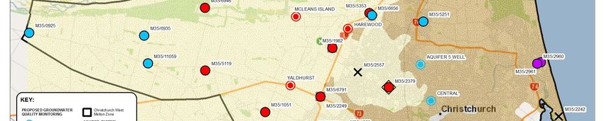
7.2.1          Monthly Fine Sediment Monitoring ............................................................ 4558
      7.2.2      Annual Aquatic Ecology Monitoring .............................................................. 4558
      7.2.3          Five-Yearly Aquatic Ecology Monitoring .................................................... 4659
    7.3       Methods .......................................................................................................... 4659
      7.3.1 Monthly Fine Sediment Monitoring ................................................................... 4659
      7.3.2 Annual and Five-Yearly Aquatic Ecology Monitoring ......................................... 4760
      7.3.3 Habitat, Periphyton and Macrophytes............................................................... 4760
      7.3.4 Macroinvertebrates .......................................................................................... 4962
      7.3.5 Fish ................................................................................................................. 4962
    7.4       Reporting ........................................................................................................ 5063
8    Mana Whenua .......................................................................................................... 5166
    8.1       Background .................................................................................................... 5166
    8.2       Sampling Sites and Frequency...................................................................... 5166
    8.3       Methods .......................................................................................................... 5469
    8.4       Reporting ........................................................................................................ 5671
9    Reporting ................................................................................................................. 5876
10 References .............................................................................................................. 5977
Appendix A: Soil Quality Monitoring Sites................................................................... 6593
Appendix B: Surface Water, Instream Sediment and Aquatic Ecology Monitoring Sites
   6694
Appendix C: Metal Hardness Modified Trigger Values .............................................. 93122
Appendix D: Surface Water, Instream Sediment, Aquatic Ecology and Mana Whenua
Monitoring Schedule ................................................................................................... 99128

                                                                                                                                      4
1         Introduction

1.1       Background and Purpose

In accordance with the consent conditions of the Comprehensive Stormwater Network
Discharge Consent (CSNDC), the primary purpose of this Environmental Monitoring
Programme (EMP) is to assess the extent of mitigation of effects of stormwater discharges
from the Christchurch City Council stormwater network on the receiving environment. Some
of the monitoring will also have the added benefit of informing the refinement and
improvement of waterway health and stormwater management practices in general.

This EMP includes details (including site info and methodology) of the monitoring of:
      ·   Infiltration facilities;
      ·   Groundwater;
      ·   Surface water levels;
      ·   Surface water quality;
      ·   Instream sediment quality;
      ·   Aquatic ecology; and
      ·   Mana whenua.

This programme includes additional monitoring to that required under the consent conditions.
This is to provide additional information useful to improve waterway health and mitigate the
effects of stormwater discharges under this consent, such as prioritisation of areas for
management. It is also useful information that can be used for the purposes of achieving CCC
plans, strategies and policies. Some of this information will not specifically be linked to
consent conditions, but will be included in the monitoring report, as detailed throughout the
document.

1.2       Current Environmental Monitoring Programme

The Christchurch City Council (CCC) currently carries out monitoring of treatment facilities,
surface water levels, surface water quality, instream sediment quality and aquatic ecology
throughout Christchurch. This monitoring is to fulfil the requirements of:
(a) monitoring programmes for existing stormwater discharge consents from Environment
      Canterbury (ECan) (Table 1);
(b) CCC policies and strategies (e.g. District Plan and Surface Water Strategy); and
(c) to provide information for the operation and development of the stormwater and
      wastewater networks.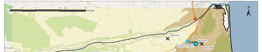
Table 1. Existing Christchurch City Council stormwater discharge consent monitoring
programmes

Title                                                      Consent            Reference

Interim Global Stormwater Consent Monitoring Plan          CRC090292          Dewson        &
                                                                              Rodrigo, 2009
Monitoring Programme for South-West Christchurch           CRC120223          Golder
Stormwater Management Plan                                                    Associates,
                                                                              2011
Monitoring Programme for the Pūharakekenui/Styx            CRC122598          Golder
River Stormwater Management Plan                                              Associates,
                                                                              2012

The results of this monitoring are currently summarised annually in reports submitted to ECan
to fulfil the conditions of the three current stormwater consents. These reports are also used
Council-wide for a number of other reasons (e.g. to assess community outcomes). The
existing monitoring programme will be formalised into this one document, and updated for the
purposes of both the CSNDC and other CCC requirements.
One of the purposes of the Interim Global Stormwater Consent (IGSC) monitoring plan was
“to collect information relating to the impacts of stormwater from various land-uses within a
range of SWMP catchments, and the performance of various stormwater devices used to
treat stormwater” (Dewson & Rodrigo, 2009). This baseline data has been used to better
understand the impacts of stormwater within the city and help in the development of
stormwater management practices. Because of this wider objective, the monitoring
programme for the IGSC was more comprehensive than is intended for the CSNDC. The
CSNDC EMP will focus on measuring whether the Receiving Environment Objectives and
Attribute Target Levels, as specified in the resource consent conditions, are being met.

                                                                                             6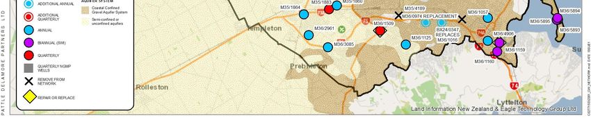
2        Soil Quality Monitoring at Infiltration Facilities

2.1      Purpose for Monitoring under this Consent

The purpose of this monitoring is to ensure that the infiltration treatment facilities do not
accumulate contaminants to a point where they may negatively impact groundwater quality.

2.2      Soil Quality Monitoring

Under the IGSC, soil quality monitoring took place at five sites which were selected to
represent infiltration or soakage systems and dry detention ponds servicing a range of land-
uses across the city. It is proposed to continue to monitor those sites, but also add in two
representative rain garden sites. Soils within the five IGSC representative facilities were
monitored in 2010 and 2015, and this will continue on a five-yearly basis. This information will
help determine the rate of contaminant accumulation and at what point remediation measures
need to take place. The sites and parameters to be analysed are shown in Table 2 and in
Figure 1, with coordinates provided in Appendix A.

Table 2. Soil sampling monitoring of stormwater devices. Cu = total recoverable
copper; Zn = total recoverable zinc; Pb = total recoverable lead; As = total recoverable
arsenic; Cd = total recoverable cadmium; Cr = total recoverable chromium; Ni = total
recoverable nickel; PAH = Polycyclic Aromatic Hydrocarbons; SVOC = Semi-Volatile
Organic Compounds.

     Location         Type of          Land Use          Year System        Parameters to be
                      System                             Constructed            Tested
    Denton Park       Soakage          Residential           1997            Cu, Zn, Pb, PAH
                       Basin
    Beckenham        Detention          Car Park             2005            Cu, Zn, Pb, PAH
      Library         Swale
    Tumara Park    Infiltration and      Large               2003            Cu, Zn, Pb, PAH
                      Detention        Residential
   Hornby            Infiltration       Industrial           1995           As, Cd, Cr, Cu, Ni,
Industrial Park        Basin                                                  Pb, Zn, PAH,
                                                                                 SVOCs
     Richmond        Swale and        High Density           2007            Cu, Zn, Pb, PAH
      Housing        First- flush       Housing
     Complex            Basin
    Grove Road      Rain Garden       Commercial             2015            Cu, Zn, Pb, PAH

                                                                                                  7
Figure 1 Location of soil monitoring sites

                                             8
2.3        Soil Sampling Protocol

A representative sample of the soil shall be collected from the relevant soil adsorption basin.
The sample shall be collected from a depth of between zero and 50 millimetres below the
ground surface at the point of lowest elevation. All samples shall be collected using a
stainless steel trowel pre-cleaned with phosphate free detergent and transferred immediately
into jars or containers provided by the laboratory. Field personnel shall wear gloves at all
times during sampling.

A completed chain of custody shall accompany all samples dispatched to an external testing
laboratory. Samples shall be stored in a chilly bin on ice until delivery to the laboratory. At
each sampling location a field sheet shall be completed describing the site characteristics and
photographs taken of the basin surface.

2.4        Analysis

Analysis of soil adsorption basin samples shall be undertaken by an IANZ accredited
laboratory. Detection limits for each parameter shall be suitable to enable comparison of the
results with relevant guidelines and trigger levels for reporting purposes.

The soil sample results shall be compared against the most appropriate and relevant soil
quality guideline values depending on dominant land use surrounding the stormwater
treatment systems and the use of the individual treatment systems (i.e. recreational reserve).
The following documents will be assessed as to their suitability for comparison with the
results:
      ·    Contaminated Land Management Guidelines No. 2 – Hierachy and application in New
           Zealand of environmental guideline values (Ministry for the Environment, 2003a);
      ·    Guidelines for Assessing and Managing Petroleum Hydrocarbon Contaminated Sites
           in New Zealand (Ministry for the Environment, 1999);
      ·    Australian and New Zealand Guidelines for Fresh and Marine Water Quality
           (ANZECC, 2000); and
      ·    Trigger values for soil quality contained in other Christchurch City Council stormwater
           discharge consent conditions.

The guidelines that are deemed most suitable for comparing the soil sample results will be
accompanied by a justification for their use and suitability.

                                                                                                 9
2.5        Reporting

The annual monitoring report for the consent shall include a report on the visual inspections
and soil quality monitoring undertaken during the previous calendar year. This report shall
include:
      ·    A summary of the visual inspections undertaken;
      ·    A summary of any soil quality monitoring;
      ·    Identification of key issues and any trends noted;
      ·    Summary of any notifications made to ECan and why;
      ·    Responses undertaken to any issues identified; and
      ·    Recommendations for changes to the maintenance and operation of the facilities.

                                                                                             10
3 Groundwater
Stormwater management has the potential to affect groundwater levels, flow in spring-fed
streams and groundwater quality. Therefore, the objective of the groundwater and spring
monitoring programme shall be to provide ongoing information on groundwater levels, spring
flows and groundwater quality so that current trends can be determined and compared with
historical patterns. In achieving this objective in the most efficient manner, use will be made of
existing monitoring programs operated by both CCC and ECan.
3.1 Groundwater Quantity
3.1.1 City-Wide Shallow Groundwater Levels
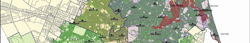
CCC carry out monthly groundwater level monitoring at the network of wells shown in Figure
2. These wells are typically 6m or less deep and provide a general coverage of the water
table elevation across the city. This network of groundwater level monitoring wells helps to
identify patterns of water level change, some of which will be affected by stormwater
management systems and land use changes that affect the area and location of pervious
surfaces and infiltration patterns.
3.1.2 Springs
Springs contribute to the overall flow and quality of surface waterways, and in general
arise from artesian sources. The discharge of stormwater is unlikely to impact on
springs, and overall issues of water flow or water quality emanating from the springs is
incorporated into the surface water monitoring programme. Particularly significant
springs are documented on CCC and ECan records, and any noteworthy changes are
likely to be noted and reported by residents and/or CCC/ECan staff. Any such reports
would be investigated to check on the cause and determine if any mitigation measures
are required.
11Figure 2 CCC groundwater level monitoring network
123.1.3 Localised Groundwater Quantity Issues
Localised groundwater drainage issues can arise from stormwater basins or can be
exacerbated by high groundwater conditions. Localised deterioration in groundwater
quality can occur from localised contamination sources, including infiltration basins. As
well as the regular monitoring, a detailed 12 month study is proposed in 2019 to
specifically investigate the impacts of infiltration facilities.
Regular Monitoring
Regular monitoring will consist of CCC responding to observations or queries about
potential groundwater drainage issues as these are received. These will be investigated
and, if it is likely to be beneficial, some monitoring of the localised situation will be
initiated to understand the groundwater related effects that may be occurring.
In the case of stormwater infiltration basins, their drainage rates will be observed by
CCC maintenance staff. If delayed drainage is occurring, investigations will be initiated
to investigate whether the cause is due to elevated groundwater levels or poor soil
infiltration characteristics.
Detailed Study
In 2019, in addition to the more general city-wide monitoring described above, a more
detailed study will be initiated for a period of at least 12 months. This will involve
monitoring at three infiltration basin facilities to assess localised changes in
groundwater levels, and the flow and quality of any nearby springs arising from the
facilities.
The methodology is yet to be fully developed, but will likely involve:
· Identification of three representative basins;
· The installation of at least one groundwater level monitoring well at each site;
· 12 months monitoring of groundwater levels;
· Monitoring in at least one new basin within the monitoring period, designed to
characterise the change from the pre-basin to post-basin environment (note this may
affect the timing of the study depending on whether a suitable basin is located); and
· Analysis and reporting.
133.2 Groundwater Quality
Two issues arise from groundwater quality; these are the quality of well water and of spring
flow. Of most importance is the potential impact on CCC public water supply wells from
stormwater discharges. Public wells are very unlikely to be affected by the activity, as public
water supply is drawn from deep artesian wells fed by deep groundwater originating from the
Waimakariri River and the inland plains. However, some shallow private wells (potentially
affected by unconfined groundwater quality) still exist in the north-west and south-west.
Environment Canterbury (ECan) carry out regular sampling of groundwater quality within the
city urban area and also in some wells further to the west which provide an indication of the
quality of groundwater moving into urban aquifers. These wells are sampled for general
chemical indicators at either quarterly or annual intervals. The locations of the currently
recommended monitoring wells are shown in Figure 3 (from Scott, 2013). These monitoring
wells will be used to provide the data for analysis by the monitoring programme.
CCC carry out groundwater quality monitoring of the output from their public water supply
pumping stations. Monitoring for Escherichia coli is carried out each day at a pumping station
supplied by shallow wells in the north-west zone of the CCC water supply network. This
sampling schedule cycles through the pumping stations so that repeat samples from each
station are collected at a frequency of around 3 or 4 times per month. Pumping stations
supplied by deep wells or located in areas other than the north-west are sampled for E. coli
once a month.
In addition to the E. coli sampling, a representative selection of wells is sampled every year
for a full chemical analysis by CCC. The wells are selected so as to take
representative samples from each aquifer each year, and to have each aquifer at each
pumping station tested every 5 years.
The CCC water supply network changes from time to time as new wells are drilled and poorly
performing wells are decommissioned. The current location of the water supply wells are
shown in Figure 4.
The data from this network of wells will be used to assess, on an annual basis, the effects of
stormwater on:
· Groundwater quality patterns for copper, lead and zinc in ECan monitoring wells;
· E. coli detections in CCC water supply wells; and
· Groundwater quality patterns for copper, lead and zinc from CCC water supply wells.
14Figure 3 ECan groundwater quality monitoring network
15Figure 4 CCC water supply pumping station locations
163.2.1 Localised Groundwater Quality Issues
Localised deterioration in groundwater quality can occur from localised contamination
sources, including infiltration basins. Regular monitoring will be undertaken, as well as
an in-depth 12 month study proposed in 2019 to specifically investigate the impacts of
infiltration facilities.
Regular Monitoring
Regular monitoring will consist of CCC responding to observations or queries about
potential groundwater quality issues as these are received. These will be investigated
and, if it is likely to be beneficial, some monitoring of the localised situation will be
initiated to understand the groundwater related effects that may be occurring.
Detailed Study
In 2019, in addition to the more general city-wide monitoring described above, a more
detailed study will be initiated for a period of at least 12 months. This will involve
monitoring at three infiltration basin facilities to assess localised changes in
groundwater quality.
The methodology is yet to be fully developed, but will likely involve:
· Identification of three representative basins;
· The installation of at least one groundwater level monitoring well at each site;
· 12 months monitoring of groundwater quality;
· Monitoring in at least one new basin with the monitoring period designed to
characterise the change from the pre-basin to post-basin environment (note this may
affect the timing of the study depending on whether a suitable basin is located); and
· Analysis and reporting.
3.3 Reporting
Groundwater monitoring should be reviewed on an annual basis, and a report prepared
to identify any results or patterns that are likely to have resulted from stormwater
management issues. The annual report should include the following topics:
· Groundwater level patterns in CCC water level monitoring wells;
· Groundwater quality patterns for copper, lead and zinc in ECan monitoring wells;
· E. coli detections in CCC water supply wells;
· Groundwater quality patterns for copper, lead and zinc from CCC water supply wells;
· Any information from spring monitoring that could be attributed to stormwater impacts
on groundwater;
17· Statistical analyses of change for E. coli (daily data from pumping stations) and
electrical conductivity (quarterly data at ECan monitoring wells; used as an indicator
of changes in metals levels) shall be undertaken using Time Trends or other robust
analysis, using a statistical level of significance of 5% (i.e. p4 Surface Water Levels and Flows, Sea Level and Rainfall Depth
4.1 Purpose for monitoring under this consent
Monitoring of surface water levels and flows, sea level and rainfall depth enables CCC to
assess the accuracy of the water quantity models developed for the Pūharakekenui/ Styx,
Ōtakaro/ Avon, Ōpāwaho/ Heathcote River and Huritini/ Halswell Rivers. This in turn allows
CCC to confirm whether the conditions of consent are being met.
CCC intends to use monitoring data collected, along with surveyed flood extents during
significant rainfall events, to validate and calibrate its stormwater quantity models for the
Pūharakekenui/ Styx, Ōtākaro/ Avon, Ōpāwaho/ Heathcote and Huritini/ Halswell Rivers.
Further, as new greenfields developments and their associated stormwater mitigation
systems are completed and commissioned, the models will be updated as needed to ensure
the expected progress is being made toward the Maximum Probable Development (MPD)
flood mitigation targets set in Schedule 7 of the consent.
4.2 Sites
CCC has maintained and added to the hydrometric1 network which was established by the
Christchurch Drainage Board. This network consists of monitoring sites for surface water
levels and flows, sea level, rainfall and groundwater levels (the latter discussed in the
groundwater section of this document). The data collected from this network is used for the
Council’s management of the rivers and for the design of stormwater networks. Data is also
used for emergency management purposes, particularly in time of flood. CCC engages a
subcontractor to maintain the hydrometric network and collect the data. Quarterly and annual
reports are produced that summarise the data, and make recommendations for maintenance
and upgrades.
4.2.1 Surface Water Level and Flows
Continuous water level gauging data began in about 1980 and additional sites were added in
1989. CCC currently obtains data from 25 river level gauges (Figures 5 and 6). This includes
20 permanent and 5 project-based sites. The permanent river level gauges are telemetered
and provide real time information at 15 minute (or less) intervals. Project-based gauges are
typically connected to a data-logger which is downloaded monthly. River flow is calculated at
eight rated sites (both permanent and project-based). Regular flow gaugings are undertaken
to maintain accurate ratings. In addition to the automatically gauged sites, there are a number
of locations with staff gauges. Levels at these sites can be recorded manually as needed.
1
Hydrometry refers to the measurement of all elements in the hydrological cycle. In this context the
hydrometric network refers to the measurement of rainfall, surface water levels and flows, and
groundwater levels.
19Figure 5 Location of water level sites (City)
20Figure 6 Location of water level sites (Banks Peninsula)
214.2.2 Sea Level
The National Institute of Water and Atmospheric Research (NIWA) maintains a CCC/ECan
sea level monitoring site at Sumner Head in Scarborough (Figure 5). Tide levels have been
analysed and statistics generated by NIWA based on recordings at the Pūharakekenui/ Styx
River tide-gates, Sumner Head, Avon River at Bridge Street and Heathcote River at
Ferrymead (Goring, 2008; Goring, 2011). This information is used to inform the downstream
water levels which are critical to the functioning of the Otakaro/ Avon and Ōpāwaho/
Heathcote River models, and also inform long-term planning decisions.
4.2.3 Rainfall Depth
There is a network of 21 rain gauges which presently provide real time information at 15
minute (or less) intervals (Figures 7 and 8). The longest record is the almost continuous daily
rainfall record for the Botanic Gardens dating back as far as 1873. However, it was not until
1962 that records of rainfall began at hourly intervals and this has progressively been reduced
to sub-hourly recording. This provides Christchurch with a good basis for its rainfall statistics,
which have been compiled by NIWA for use in stormwater design (Griffiths et al, 2009).
4.3 Reporting
CCC will report on the stormwater quantity models in the annual report on a 5-yearly basis,
starting in the year 2020. Reporting will cover:
· Any significant changes made to the input parameters of the models;
· Any significant changes to development patterns (greenfield or brownfield);
· Any significant updates to model hydraulics (bridges, culverts, etc.);
· Any significant calibration or validation exercises undertaken;
· A discussion of progress toward meeting the flood mitigation targets set in Schedule
7 of the consent; and
· Any other relevant discussion involving changes to models or analysis of modelling
results.
In addition, CCC maintains a database with all recorded data to be made available as needed
for projects or updating of hydrological models. TIDEDA (a NIWA product for storing and
analysing time dependent data) is used to allow detailed analysis of the data. Quarterly and
annual reports are produced, with a summary of the data and a review of operational issues.
22Figure 7 Location of rainfall depth sites (City)
23Figure 8 Location of rainfall depth sites (Banks Peninsula)
245 Surface Water Quality
5.1 Background
Water quality monitoring of waterways has been undertaken previously by the CCC for many
decades, with regular monthly sampling being undertaken at numerous sites in Christchurch
since 2007. This new monitoring programme builds on this past monitoring by including
additional sites and receiving environments.
5.2 Sampling Sites and Frequency
5.2.1 Regular Monitoring
A total of 53 sites within the waterways and coastal areas of Christchurch and Banks
Peninsula shall be monitored monthly (Figures 9 to 15; Appendix B). These sites
predominantly include (a) waterways within the five main river catchments of Christchurch
(Otakaro/ Avon River, Ōpāwaho/ Heathcote River, Puharakekanui/ Styx River, Huritini/
Halswell River and Ōtūkaikino River), (b) waterways within Banks Peninsula settlement areas
and (c) coastal areas (estuaries and ports, within Christchurch and Bank Peninsula).
5.2.2 Wet Weather Monitoring
Wet weather monitoring of waterways has previously been undertaken as part of stormwater
discharge consents requirements. This new monitoring programme builds on this monitoring,
by including more sites. Wet weather monitoring is to be undertaken at 26 sites within the five
main Christchurch river catchments and four sites from coastal areas (Figures 9 to 15;
Appendix B). This monitoring shall be done on a five yearly rotation, in the same year as the
sediment and ecological monitoring for each catchment (Appendix B). Two wet weather
events shall be monitored each year in the relevant catchment.
Wet weather sampling shall be carried out using the following criteria:
· Dry period prior to sampling = minimum of 3 days (on advice from Ash O’Sullivan
from PDP that even 24 hours is sufficient time for contaminants to accumulate);
· Rainfall depth = minimum of 3mm total before sampling begins (based on modelling
by Tom Parsons for Avon Stormwater Management Plan that this is sufficient to
obtain the first flush of contaminants); and
· Sampling timeframe = within 1-2 hours of the desired rainfall being achieved, as
determined using MetConnect or equivalent forecasted and real-time rainfall, to
ensure first flush is captured.
25Figure 9 Location of surface water, instream sediment, aquatic ecology and mana whenua monitoring sites in the Otakaro/ Avon River Stormwater Management area
26Figure 10 Location of surface water, instream sediment, aquatic ecology and mana whenua monitoring sites in the Opāwaho/ Heathcote River Stormwater Management area
27Figure 11 Location of surface water, instream sediment and aquatic ecology monitoring sites in the Huritini/ Halswell River Stormwater Management Plan area
28Figure 12 Location of surface water, instream sediment, aquatic ecology and mana whenua monitoring sites in the Pūharakekenui/ Styx River Stormwater Management Plan area
29Figure 13 Location of surface water, instream sediment and aquatic ecology monitoring sites in the Outer Christchurch Stormwater Management Plan area
30Figure 14 Location of surface water, instream sediment and aquatic ecology monitoring sites in the Banks Peninsula Stormwater Management Plan area
31Figure 15 Location of surface water, instream sediment and aquatic ecology monitoring sites in the in the Estuary and Coastal Stormwater
Management Plan area
32This page is intentionally left blank.
335.3 Methods
The sample collection and laboratory analysis methods detailed in this section are consistent
with past sampling undertaken by the CCC (primarily for stormwater consenting
requirements). Samples from tidal sites shall be taken during low tide, with sampling within
catchments starting at the most downstream site. Low tide times for Lyttelton and Akaroa
sites shall be based on their respective harbour tide times, while low-tide tide times for the
Otakaro/ Avon River, Opāwaho/ Heathcote River and the Avon Heathcote Estuary/Ihutai shall
be considered to be one hour after the low tide in Lyttelton Harbour.
Samples of water from each site shall be collected and analysed as follows:
· Samples should be collected from an area most representative of the site and should
be in approximately the same location each time sampling is undertaken;
· Samples may be collected in a bucket before transfer to an appropriate, correctly
labelled bottle, provided the bucket is rinsed twice beforehand with water from the
site;
· Bottles (and lids) that do not have preservative should be rinsed with a small amount
of water from the site immediately prior to sample collection and the rinsate discarded
away from the sampling site; any bottles with preservative in them must not be rinsed,
nor filled to overflowing as the preservative will be lost;
· Never allow the inner surface of a sample container or lid to be contacted by any
material other than the sample water;
· Samples shall be dispatched in bottles prepared by an International Accreditation
New Zealand (IANZ) accredited laboratory2 and as such will follow a Quality
Assurance Plan; samples shall be immediately stored on ice and delivered to the
laboratory within 24 hours, and a completed chain of custody form shall accompany
all samples;
· At each site, in situ measurements of conductivity, temperature and dissolved oxygen
shall be recorded at the same representative location as water samples were taken;
and
· Samples shall be analysed for the parameters in Table 3 by an IANZ accredited
laboratory; detection limits for each parameter shall be suitable to enable comparison
of the results with relevant guidelines for reporting purposes.
Hardness will also be monitored across each waterway site every five years, to review the
appropriateness of the hardness modified guideline values (i.e. copper, lead and zinc) for
2
The Christchurch City Council Laboratory is an IANZ accredited laboratory and currently undertakes
the analyses
34each catchment. The first review will be undertaken in 2020. During this review, each site will
be monitored three times throughout the monitoring year, to establish these hardness values.
Values will be calculated in the same manner as that detailed in Appendix C, using the
algorithms in the ANZECC (2000) guidelines. There is the potential that the guideline
modifiers will change in the future and this assessment will be adapted to meet these new
requirements.
The parameters to be tested were chosen specifically due to the following potential effects on
instream biota, determined by whether the following guidelines are being met, as detailed in
Table 3:
· Metals, in particular, copper, lead and zinc, can be toxic to aquatic organisms,
negatively affecting such things as fecundity, maturation, respiration, physical
structure and behaviour (Harding, 2005). The toxicity of metals in water, and
therefore the risk of adverse biological effects, alters depending on the hardness, pH
and alkalinity of the water (ANZECC, 2000). Therefore, trigger levels should be
calculated with consideration of water hardness (ANZECC, 2000). The CCC has
previously calculated Hardness Modified Trigger Values (HMTV) for metals in
Christchurch City waterways in accordance with ANZECC (2000) methodology (see
Appendix C). Values for Banks Peninsula sites will be calculated after the initial year
of monitoring, based on the same ANZECC (2000) methodology, or any other
relevant methodology should these requirements change. For coastal sites, the
Regional Coastal Environment Plan (RCEP; Environment Canterbury, 2012) details
guideline values of 0.005 mg/L for copper and lead, and 0.05 mg/L for zinc.
· pH is a measure of acidity or alkalinity, on a scale from 0 to 14; a pH value of seven is
neutral, less than seven is acidic and greater than seven is alkaline. Appropriate pH
levels are essential for the physiological functions of biota, such as respiration and
excretion (Environment Canterbury, 2009). Aquatic species typically have tolerances
for certain pH levels and alteration of pH can result in changes in the composition of
fish and invertebrate communities, with generally a positive relationship between pH
and the number of species present (Collier et al, 1990). The guidelines in the Land
and Water Regional Plan (LWRP; Environment Canterbury, 2015) for all waterways
are a lower limit of 6.5 and an upper limit of 8.5. The ANZECC (2000) guidelines have
a guideline value for estuaries of 7.0 - 8.5.
· Conductivity is a measure of how well water conducts an electrical current. Pure
water has very low conductivity, but dissolved ions in the water (e.g. contaminants
such as metals and nutrients) increase conductivity. Traditionally, conductivity in
waterways has been compared to the guideline value ofbe less relevant in urban waterways, where other contaminants that will not
encourage periphyton growth may be contributing to high conductivity, such as
metals. It is also noted that ECan do not consider this guideline value is useful, due to
natural variations in levels (Abigail Bartram, ECan, personal communication 2013).
They instead consider that analysis of trends is more useful. There are no New
Zealand guidelines for conductivity in coastal environments and it is more relevant to
measure salinity in any case. There are no guidelines for salinity either.
· Elevated levels of suspended sediment (Total Suspended Solids, TSS) in the water
column decrease the clarity of the water and can adversely affect aquatic plants,
invertebrates and fish (Crowe & Hay, 2004; Ryan, 1991). For example, sediment can
affect photosynthesis of plants and therefore primary productivity within streams,
interfere with feeding through the smothering of food supply, and can clog suitable
habitat for species (Crowe & Hay, 2004; Ryan, 1991). The LWRP (decisions version)
details in Rule 5.95 standards for TSS in stormwater prior to discharge, but does not
detail specifically a guideline value within waterways. Ryan (1991) recommends a
guideline value of 25 mg/L to ensure protection of aesthetic and ecological values.
There are no New Zealand guidelines for coastal environments.
· Turbidity is a measure of the transmission of light through water. Suspended matter in
the water column causes light to be scattered or absorbed as is travels through the
water. As for TSS, turbidity decreases the clarity of the water and can negatively
affect stream biota (Ryan, 1991). A guideline level for this parameter is not provided
in the LWRP. ANZECC (2000) provides a guideline of 5.6 Nephelometric Turbidity
Units (NTU) for lowland rivers andphosphorus, and indicate the potential for bacteria to deplete oxygen levels in the
water. The LWRP does not have a guideline level for this parameter. The Ministry for
the Environment (1992) and RCEP (2012) guideline level is 2 mg/L.
· Total ammonia (ammoniacal nitrogen) is typically a minor component of the nitrogen
available for plant growth, but at high levels can have toxic effects on aquatic
ecosystems. The toxicity of ammonia varies with pH (ANZECC, 2000). Therefore, the
LWRP water quality standards also vary depending on pH, ranging from 2.57 mg/L at
pH 6 to 0.18 mg/L at pH 9 (Environment Canterbury, 2015). The water quality
standard for this monitoring shall be adjusted based on the median pH levels for the
relevant catchments. The exception to this is for Banks Peninsula waterways which
have a set guideline value regardless of pH (0.32 mg/L; Environment Canterbury,
2015). The ANZECC guidelines have a trigger value for coastal environments of
0.015 mg/L (ANZECC 2000).
· Nitrate can also be toxic to stream biota and specific guidelines for this parameter
have recently been developed to protect freshwater species (Hickey, 2013).
Guidelines are available for different species protection levels: 99% (pristine
environment with high biodiversity and conservation values), 95% (environments
which are subject to a range of disturbances from human activities, but with minor
effects), 90% (environments which have naturally seasonally elevated concentrations
for significant periods of the year (1-3 months)), 80% (environments which are
measurably degraded and which have seasonally elevated concentrations for
significant periods of the year (1-3 months)), and acute (environments which are
significantly degraded; probable chronic effects on multiple species). Based on these
descriptions and the predominantly urban nature of the waterways monitored, most of
the waterways would fall under the 80% to acute species description (i.e. Otakaro/
Avon, Opāwaho/ Heathcote and Huritini/ Halswell River catchments). However, the
Pūharakekenui/ Styx and Ōtūkaikino River catchments (and Cashmere Stream) likely
fall under the 90% species protection. To be conservative, the 90% species protection
shall be used as the guideline level for all waterways. Within this 90% level of species
protection there are two guideline values: the ‘grading’ guideline (3.8 mg/L) that
provides for ecosystem protection for average long-term exposure (measured against
medians) and the ‘surveillance’ guideline (5.6 mg/L) that assesses seasonal
maximum concentrations (measured against annual 95% percentiles). There are no
New Zealand guidelines for coastal environments.
· Elevated concentrations of Nitrate Nitrite Nitrogen (NNN) can lead to the proliferation
of aquatic plants and algae, because nitrate and nitrite are oxidised forms of nitrogen
that are readily available to plants. The LWRP does not have a guideline value for
this parameter, but the ANZECC (2000) water quality guidelines provide a trigger
value of 0.444 mg/L for lowland rivers and 0.015 mg/L for coastal sites.
37· Dissolved Inorganic Nitrogen (DIN), which is the sum of ammonia, nitrite and nitrate,
provides a measure of the risk of eutrophication and toxicity (Environment
Canterbury, 2015). The LWRP details a value of 1.5 mg/L for 'spring-fed – plains' and
'spring-fed – plains – urban' waterways, and 0.09 mg/L for Banks Peninsula
waterways. There are no New Zealand guidelines for coastal environments.
· Dissolved Reactive Phosphorus (DRP) is a soluble form of phosphorus that is readily
available for use by plants. Phosphorus is an essential nutrient for plant growth and
can limit primary production at low levels, but can cause proliferation of algae and
aquatic plants at high levels. The guideline levels in the LWRP for 'spring-fed - plains'
and 'spring-fed – plains – urban' waterways are 0.016 mg/L, and 0.025 mg/L for
Banks Peninsula waterways. The ANZECC (2000) guidelines have a trigger value of
0.005 mg/L for coastal environments.
· Escherichia coli is a bacterium that is commonly used as an indicator of faecal
contamination in freshwater and therefore health risk from contact recreation (Ministry
for the Environment, 2003b). The guideline level in the LWRP for 'spring-fed – plains',
'spring-fed – plains – urban' and Banks Peninsula waterways is 550 E. coli per 100ml
(for 95% of samples). There are no New Zealand guidelines for coastal environments.
· Enterococci is a faecal streptococci bacterium that is used as an indicator of faecal
contamination in saline environments and therefore health risk from contact
recreation (Ministry for the Environment, 2003b). This parameter is not relevant to
non-tidal waterway sites, only tidal waterway and coastal sites. There are guideline
levels for coastal sites in the RCEP, but these are considered difficult to measure,
with the requirement for running medians not to exceed certain values, as well as
maximum values for any given sample. These guidelines are also only in relation to
some of the site classifications and only during the summer months. Instead,
enterococci shall be compared against the Ministry for the Environment (2013)
guidelines, with more stringent levels adopted for those sites where contact
recreation is more likely to occur (Cass Bay and Akaroa Harbour; 200 CFU/100 ml),
compared to those were contact recreation is less likely to occur (500 CFU/100 ml).
5.4 Reporting
The annual monitoring report for the consent shall include a report on the water quality
monitoring undertaken during the previous calendar year (monthly and five-yearly wet
weather). This report shall include:
· An assessment of parameter concentrations at each site against the most relevant
guideline levels (Table 3), where available, to determine likely effects on the receiving
environment due to water quality;
· Spatial comparisons of concentrations within and across catchments;
38· For the monthly data, statistical temporal trends analyses against historical data to
determine whether water quality is remaining stable, improving or declining, using
Time Trends or other robust method;
o A minimum of three years is required before trends analysis can be
undertaken in Time Trends (NIWA, 2014) and the statistical level of
significance for this analysis shall be 5% (i.e. pTable 3. Parameters to be analysed in surface water samples and the corresponding guideline levels. Guidelines should be compared to
median levels from one calendar year of monitoring, unless otherwise indicated. HMTV = Hardness Modified Trigger Value; RCEP =
Regional Coastal Environment Plan; LWRP = Land and Water Regional Plan; ANZECC = Australia and New Zealand Environment and
Conservation Council. TBC = To Be Confirmed once a full year of monitoring allows hardness modified values to be calculated; these
values will be calculated for each waterway using ANZECC (2000) methodology, or any other method that supersedes.
Parameter Waterway Guideline Level Coastal Guideline Level
ANZECC (2000) HMTV (95th percentile, not medians): RCEP (Environment Canterbury, 2012):
· Otakaro/ Avon River catchment (90% species · ≤0.005 mg/L
protection): ≤0.00356 mg/L
· Opāwaho/ Heathcote River catchment (90%
species protection): ≤0.00543 mg/L
· Cashmere Stream (99% species protection: ≤0.00302 mg/L
Dissolved · Huritini/ Halswell River catchment (95% species protection):
copper ≤0.00336 mg/L
· Pūharakekenui/ Styx River catchment (95% species
protection): ≤0.00212 mg/L
· Ōtūkaikino River catchment (95% species protection):
≤0.00152 mg/L
· Linwood Canal (90% species protection): 0.0175 mg/L
· Banks Peninsula: TBC
ANZECC (2000) HMTV (95th percentile, not medians): RCEP (Environment Canterbury, 2012):
· Otakaro/ Avon River catchment (90% species · ≤0.005 mg/L
protection): ≤0.01554 mg/L
· Opāwaho/ Heathcote River catchment (90%
species protection): ≤0.02916 mg/L
· Cashmere Stream (99% species protection:
≤0.00521 mg/L
Dissolved lead · Huritini/ Halswell River catchment (95%
species protection): ≤0.01257 mg/L
· Pūharakekenui/ Styx River catchment (95%
species protection): ≤0.00634 mg/L
· Ōtūkaikino River catchment (95% species protection):
≤0.00384 mg/L
· Linwood Canal (90% species protection): 0.167 mg/L
· Banks Peninsula: TBC
ANZECC (2000) HMTV (95th percentile, not medians): RCEP (Environment Canterbury, 2012):
· Otakaro/ Avon River catchment (90% species · ≤0.05 mg/L
protection): ≤0.02970 mg/L
· Opāwaho/ Heathcote River catchment (90%
species protection): ≤0.04526 mg/L
· Cashmere Stream (99% species protection:
≤0.00724 mg/L
Dissolved zinc · Huritini/ Halswell River catchment (95%
species protection): ≤0.01919 mg/L
· Pūharakekenui/ Styx River catchment (95%
species protection): ≤0.01214 mg/L
· Ōtūkaikino River catchment (95% species protection):
≤0.00868 mg/L
· Linwood Canal (90% species protection): 0.146 mg/L
· Banks Peninsula: TBC
Total water No New Zealand guidelines currently exist; should they become Not to be tested
hardness and available these will be used; this parameter is usually only
Dissolved relevant to determine the toxicity of other parameters such as
Organic Carbon metals
(DOC)
LWRP (Environment Canterbury, 2015): ANZECC (2000)3:
pH
· All waterways: 6.5 - 8.5 · 7.0 - 8.5
No New Zealand guidelines currently exist; should they become No New Zealand guidelines currently exist; should they become
Conductivity
available these will be used available these will be used
No New Zealand guidelines currently exist, should they become No New Zealand guidelines currently exist, should they become
Salinity4
available these will be used available these will be used
Total Ryan (1991): No New Zealand guidelines currently exist; should they become
Suspended · All waterways: ≤25 mg/L available these will be used
Solids (TSS)
ANZECC (2000): ANZECC (2000)3:
Turbidity
· All waterways: ≤5.6 NTU · ≤10 NTU
LWRP (Environment Canterbury, 2015): RCEP (Environment Canterbury, 2012):
Dissolved · ‘Spring-fed – plains – urban’ and ‘spring-fed – plains · ≥ 80 %
Oxygen (DO) waterways:’ ≥70 %
· Banks Peninsula waterways: ≥90
3
These values are from the ANZECC (2000) guidelines for estuaries of South-East Australia; the guidelines recommend these values are used for New Zealand while
no other guidelines are available, but they should be used with caution due to the differing ecosystems between countries (in particular, our higher nitrogen levels)
and replaced with national guidelines should they become available
4
Salinity and enterococci are to be tested at the four tidal waterway sites (Avon River at Bridge Street Bridge, Heathcote River at Ferrymead Bridge, Styx River at
Harbour Bridge and Linwood Canal) and all coastal sites
40Parameter Waterway Guideline Level Coastal Guideline Level
Water LWRP (Environment Canterbury, 2015): RCEP (Environment Canterbury, 2012):
temperature · All waterways: ≤20ºC · ≤25°C
Biochemical Ministry for the Environment (1992): RCEP, excluding The Operational Area of the Port of Lyttelton
Oxygen · All waterways: ≤2 mg/L (Environment Canterbury, 2012):
Demand (BOD5) · ≤2 mg/L
LWRP (Environment Canterbury, 2015): ANZECC (2000) 3:
Total ammonia
· Banks Peninsula waterways: ≤0.32 mg/L · ≤0.015 mg/L
(ammoniacal
nitrogen) · All other waterways: determined by median catchment pH,
as per the LWRP
Hickey (2013): No New Zealand guidelines currently exist; should they become
· All waterways grading guideline: ≤3.8 mg/L available these will be used
Nitrate nitrogen
· All waterways surveillance guideline (95th percentile, not
medians): ≤5.6 mg/L
Nitrate-Nitrite- ANZECC (2000): ANZECC (2000) 3:
Nitrogen (NNN) · All waterways: ≤0.444 mg/L · ≤0.015 mg/L
LWRP (Environment Canterbury, 2015): No New Zealand guidelines currently exist; should they become
Dissolved available these will be used
· ‘Spring-fed – plains – urban’ and ‘spring-fed – plains’
Inorganic
waterways: ≤1.5 mg/L
Nitrogen (DIN)
· Banks Peninsula waterways: ≤0.09 mg/L
No New Zealand guidelines currently exist; should they become No New Zealand guidelines currently exist; should they become
Nitrite nitrogen
available these will be used available these will be used
Dissolved LWRP (Environment Canterbury, 2015): ANZECC (2000)3:
Reactive · ‘Spring-fed – plains – urban’ and ‘spring-fed – plains’ · ≤0.005 mg/L
Phosphorus waterways: ≤0.016 mg/L
(DRP) · Banks Peninsula waterways: ≤0.025 mg/L
LWRP (Environment Canterbury, 2015): No New Zealand guidelines currently exist; should they become
Escherichia coli5 · All waterways: ≤550 CFU/100ml (95th percentile, not available these will be used
medians)
Ministry for the Environment (2013): Ministry for the Environment (2013)6:
· At all measured sites: ≤500 CFU/100 ml (95 percentile, not
th
· Cass Bay and Akaroa Harbour: ≤200 CFU/100 ml (95th
4
Enterococci medians) percentile, not medians)
· Avon Heathcote Estuary/Ihutai and Lyttelton Harbour: ≤500
CFU/100 ml (95th percentile, not medians)
5
Not tested to be tested in Lyttelton Harbour, Cass Bay or Akaroa Harbour, as enterococci is more relevant to these saline environments
6
These values are more stringent for coastal areas where swimming is likely to occur
416 Instream Sediment Quality
6.1 Background
The quality of sediment within Christchurch waterways has been analysed on one-off
occasions a number of times since the inception of the CCC and the former Christchurch
Drainage Board. This new monitoring programme again builds on this past monitoring, by
monitoring additional sites on a more regular basis.
6.2 Sampling Sites and Frequency
Waterway sediments shall be sampled at 45 sites from Christchurch’s main river catchments
and four sites from Banks Peninsula (Figures 9 to 15; Appendix B). The year of sampling is to
coincide with the five-yearly catchment rotation for wet weather water quality and aquatic
ecology monitoring (Appendix D).
6.3 Methods
The methods detailed in this section are similar to those previously used in sediment surveys
around Christchurch (e.g. Kingett Mitchell, 2005; Golder Associates, 2009; Golder Associates,
2012b; Gadd & Sykes 2014).
Samples are to be collected and analysed in the following manner:
· Samples should be collected following a period of at least three days of dry weather,
to ensure that sediments are settled and fine surface sediments have not been
removed by high flows;
· Sediment samples should be collected from the surface at a depth of no greater than
3 centimetres of sediment, which reflects the most recently accumulated sediment;
· Sampling methods should be employed with the aim of ensuring capture of sufficient
fine material (< 2 millimetres) for laboratory analyses;
· Samples are to be collected by making multiple sweeps with a container across the
stream bed to collect at least 5 subsamples, which are then composited into one
sample;
· Water shall be drained off directly from the sample container or using a 500 µm mesh
sieve;
· Following sample collection at each site, all equipment must be washed thoroughly
with water to remove all visible sediment, then rinsed with acid (10% HCl) to remove
42You can also read