Utah - Western Rivers Conservancy
←
→
Page content transcription
If your browser does not render page correctly, please read the page content below
TIM PALMER
Utah
TIM PALMER
Virgin River in Zion National Park. Cover: Green River in Dinosaur National Monument.
Letter from the President
R
     ivers are the great treasury of                                    noted scientists and other experts reviewed the survey design, and
     biological diversity in the western                                state-specific experts reviewed the results for each state.
     United States. As evidence mounts                                     The result is a state-by-state list of more than 250 of the West’s
that climate is changing even faster than we                            outstanding streams, some protected, some still vulnerable. The
feared, it becomes essential that we create                             Great Rivers of the West is a new type of inventory to serve the
sanctuaries on our best, most natural rivers                            modern needs of river conservation—a list that Western Rivers
that will harbor viable populations of at-risk                          Conservancy can use to strategically inform its work.
species—not only charismatic species like
salmon, but a broad range of aquatic and                                  This is one of 11 state chapters in the report. Also available are a
terrestrial species.                                                    summary of the entire report, as well as the full report text.
   That is what we do at Western Rivers Conservancy. We buy land           With the right tools in hand, Western Rivers Conservancy is
to create sanctuaries along the most outstanding rivers in the West     seizing once-in-a-lifetime opportunities to acquire and protect
– places where fish, wildlife and people can flourish.                  precious streamside lands on some of America’s finest rivers.
   With a talented team in place, combining more than 150 years            This is a time when investment in conservation can yield huge
of land acquisition experience and offices in Oregon, Colorado,         dividends for the future. We invite you to join forces with us as we
California, and Washington, Western Rivers Conservancy is well          work to buy and conserve high-quality lands on the Great Rivers of
positioned to fulfill its mission in 11 western states.                 the West. Please visit our website at www.westernrivers.org, or you
                                                                        may contact me at sdoroff@westernrivers.org or 503-241-0151 to
   Yet if we are to conserve the great rivers of the West, we need      learn more.
to know which rivers these are. To develop an inventory of the
highest quality rivers, we turned to Tim Palmer—a noted author          For Our Rivers,
and photographer with 35 years of experience exploring hundreds
of streams throughout the West.
   The principal goal of the survey was to develop a list of the most
outstanding natural rivers—the great rivers of the West. Criteria
included free-flowing length, natural flow regime, water quality,
biological health and habitat, ecological and regional diversity and    Sue Doroff
recreational suitability, among other attributes. A committee of        President

                                                                                                                                                 3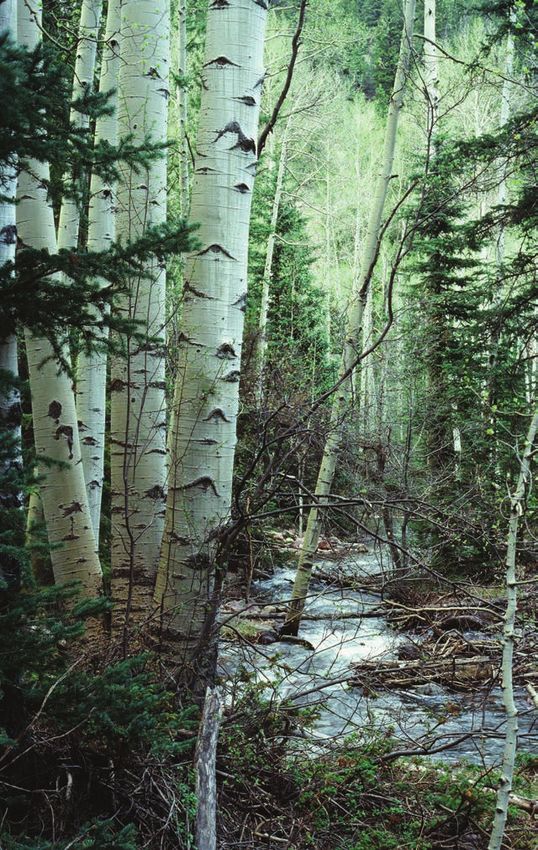
Introduction
    Great Land, Great Rivers

    R
         ivers and streams may be the most valuable of all natural
         resources in the western United States. They provide for a wide
         range of human needs—everything from drinking water and
    recreation to hydroelectricity and agriculture. At the same time,
    they offer crucial habitat and migration routes for fish and wildlife—
    often in otherwise arid landscapes. Even more fundamentally, they
    sustain vital natural processes—the hydrologic cycle, the flow of
    groundwater, and the growth of forests—that nourish all of life.
       An extraordinary network of rivers flows from mountaintops to
    deserts, lowlands, and seashores. Among thousands of streams,
    several hundred remain as exemplary natural waterways.
       Bound for the Pacific Ocean, rivers of the coastal states flow

                                                                                                                                                     TIM PALMER
    through remarkably varied terrain—from high elevations to sea
    level, and through drylands as well as the greatest temperate              White River
    rainforests on earth. In California, the Smith River is the only sizable
    undammed river in the state and still supports runs of wild salmon.
    In the Sierra Nevada, the Kings, North Fork of the Kern, and other         for combined length and natural mileage, runs for more than 400
    streams flow magnificently from alpine headwaters to lower foothill        miles through a geographic maze of eight major mountain ranges
    elevations. In Oregon, the Elk and Illinois are criterion natural rivers   and still supports one of the West’s most notable runs of salmon.
    of the Pacific Coast Range, and the Rogue is one of few rivers that        The Selway is even wilder, pulsing down from its headwaters in
    winds without development or roads as it cuts through these far-           the Bitterroot Mountains. Montana has the forks of the Flathead—
    western mountains. In Washington, an incomparable suite of still-          each remarkable for its clarity, beauty, and habitat of rare bull trout
    wild rivers drops from towering Mount Olympus, and in the glacier-         and wildlife including grizzly bears and wolves. The Yellowstone
    carved North Cascades, the Skagit and Sauk River systems are               flows for more than 600 miles without large dams, its nature still
    among the finest for salmon, steelhead, and deep forest frontage           largely intact from Rocky Mountain heights to the heart of the Great
    with long, free-flowing mileage.                                           Plains. In Wyoming, rivers of the renowned Greater Yellowstone
       In the Rocky Mountains, a few rivers remain with exceptionally          Ecosystem include outstanding tributaries to the upper Snake and
    long reaches of undammed, watery pathways through the rugged               its incomparable riparian corridor beneath the craggy peaks of the
    terrain, and others are critical to fish and wildlife even though they     Tetons. In Colorado, the Yampa has one of the finest cottonwood
    are shorter. The Salmon of Idaho, perhaps America’s premier river          forests in the West and still supports endangered warm-water fishes
                                                                               of the Colorado River basin.

4    Great Rivers of the West: UTAH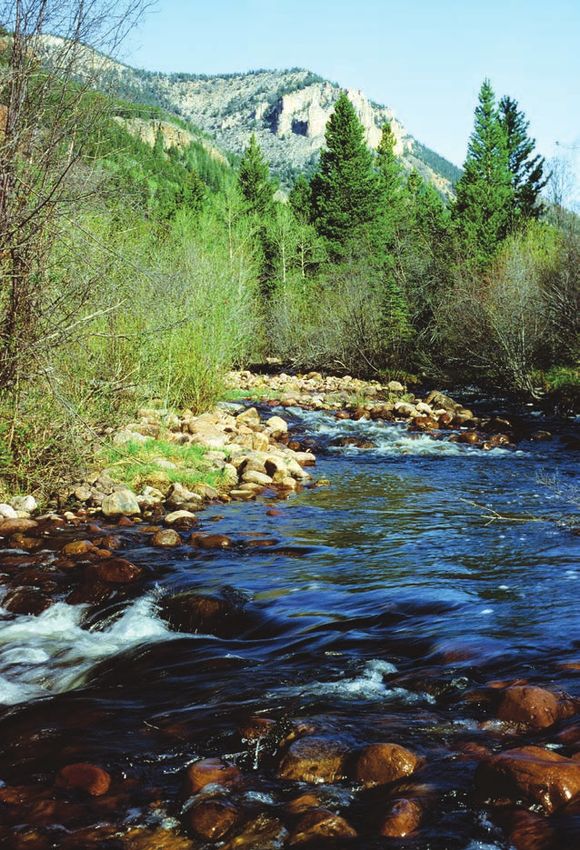
Conservancy.

                                                                                      Great Rivers of the West: The Western Rivers
                                                                                      Conservancy Survey of Eleven States

                                                                                      W
                                                                                                estern Rivers Conservancy (WRC) is dedicated to protecting
                                                                                                the outstanding rivers of the western United States.
                                                                                                Based in Portland, Oregon, but working throughout an
                                                                                      eleven-state region, this nonprofit, private organization purchases
                                                                                      riverfront property from willing, private landowners and assures
                                                                                      that the land will be conserved as open space. In this way, the
                                                                                      group has successfully protected dozens of critical riverfront tracts
                                                                                      along streams such as the Sandy, Illinois, Chetco, and Willamette

                                                                         TIM PALMER
                                                                                      Rivers in Oregon; the Hoh River and Icicle Creek in Washington; the
                                                                                      Snake River in Hells Canyon of Idaho and Oregon; the Sun River in
Confluence of the Colorado and Green Rivers                                           Montana; the Smith River and Chico Creek in California. However,
                                                                                      both the need and the opportunity to protect rivers far exceed the
                                                                                      ability of this—or any organization—to accomplish all that should
   The drylands and deserts also have their riverine highlights.                      be done. Many rivers and their landscapes must be safeguarded so
The Green of Utah flows for nearly 400 miles with native fish                         that natural ecosystems can continue to function and provide for
habitat through spectacular canyonlands, and the Virgin River is                      people’s needs in the future.
centerpiece to Zion National Park and a greater region of redrock
canyons. Nevada has mountain streams where the rare Bonneville                           To clarify its mission and focus its efforts, the WRC in 2005 adopted
and Lahontan cutthroat trout survive. New Mexico has the fabled                       a strategic plan to “protect outstanding river ecosystems in the
Rio Grande and the still-wild upper Gila; Arizona has the biologically                western United States” and to “conserve the great rivers of the West.”
rich Verde and the one-and-only Grand Canyon of the Colorado                          These are described as “healthy, natural rivers where ecological
River.                                                                                functions are still intact.” The plan emphasized “whole ecosystem
                                                                                      protection” and recognized the importance of headwaters, riparian
   These are just a few of the rivers and tributaries that still flow with            lands, estuaries, and regions that have “a high density of high-quality
exceptional natural assets throughout the American West. Much                         rivers.” To plot this ambitious course, the WRC recognized the need
of value remains, yet much of natural worth has been lost during                      to complete a survey to identify the highest quality rivers. Simply
the past two hundred years, and even some of the best-protected                       stated, if the organization is to save the “great rivers of the West,” it
waterways are threatened by mismanagement, development, or                            needs to know which rivers these are.
pollution from near or distant sources.
                                                                                          To develop the survey, the WRC hired Tim Palmer—a noted author
   To protect and restore the finest rivers that remain are goals of top              of ten books about rivers and river conservation, a planner trained
importance for the future of the West, yet no recent comprehensive                    in landscape architecture, a photographer, and an inveterate rivers
survey has been completed to identify the best natural rivers that                    enthusiast with thirty-five years of experience exploring hundreds
remain. That is the intent of this report prepared by Western Rivers                  of rivers throughout the West. A committee of noted river scientists

                                                                                                                                                                  5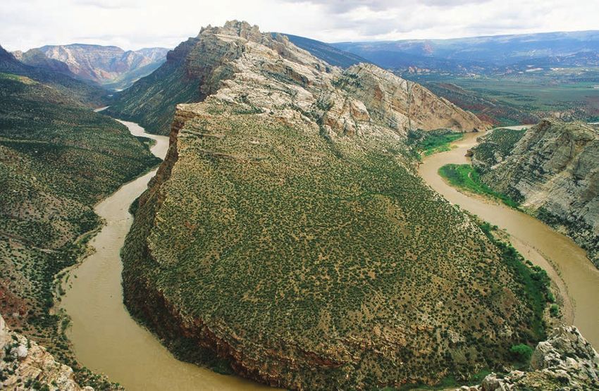
and other western river experts reviewed the survey design as it was
    being developed, and state-specific experts reviewed the results for
    each state.
       The survey examined rivers of Washington, Oregon, California,
    Idaho, Montana, Wyoming, Utah, Colorado, Nevada, Arizona,
    and New Mexico. For pragmatic reasons, Hawaii and Alaska were
    excluded.
       Rather than start from scratch, WRC survey built on past river
    inventories. These include significant studies following the National
    Wild and Scenic Rivers Act of 1968, such as the Nationwide Rivers
    Inventory (NRI), and a wide variety of other more recent studies,
    inventory lists, articles, and research papers. Typically, for each state,
    15 to 20 such sources were consulted. Each of these had its own
    “take” on the definition of quality (e.g. native fish abundance, water
    quality, recreation values), and some lists addressed only specific

                                                                                                                                                     MTNEXPLORER
    regions within a state. None told the whole story, but in aggregate,
    these earlier efforts all pointed the way or offered useful evidence. If
    a particular river was identified as excellent by half a dozen different     Escalante Canyon
    sources, for example, it was considered likely to be a “better” natural
    river than one that was identified only once. To specifically consider
    rivers’ biological values, several experts—usually fisheries biologists      no land will be acquired for open space simply because a river
    or ecologists—were interviewed for each state. Their perspective             appears on our list. And in cases where open space may eventually
    and firsthand knowledge of local rivers provided essential insights          be bought to conserve the rivers, acquisition would be only from
    for this survey’s analysis.                                                  willing sellers who voluntarily agree upon all terms. The work of
       The Great Rivers of the West does not include of all rivers               Western Rivers Conservancy and of other conservancies and land
    deserving protection. That would be a far larger list. To state this         trusts simply gives property owners an opportunity to have their
    important point another way, if a river does not appear in this              land protected if they want to do so.
    report, it implies no agreement that dams, pollution, new roads,                The need for river protection is becoming more urgent as western
    or development can occur without significant public losses in river          streams are increasingly affected by pressures of a rapidly growing
    qualities and ecosystem functions. This survey, however, is WRC’s            population; of the 10 fastest growing states in the nation on a
    attempt to identify the very best rivers that remain with outstanding        percentage basis, 7 are in the West. Such growth intensifies needs
    natural values. Furthermore, restoration efforts for rivers that are         for water and energy and spurs suburban development of farm and
    not even mentioned in this survey might someday reinstate their              ranchlands. The urgency of conserving rivers is also heightened
    natural qualities so that they, too, will again become “great rivers of      by the aggravating effects of global warming and by neglect of
    the West.”                                                                   problems that have been accumulating for many years across the
         Based on this survey, Western Rivers Conservancy will be able           watersheds of the West. In this challenging context, it is the aim of
    to better identify prime opportunities for its involvement. However,         this survey to inform the conservation of the best remaining rivers

6   Great Rivers of the West: UTAH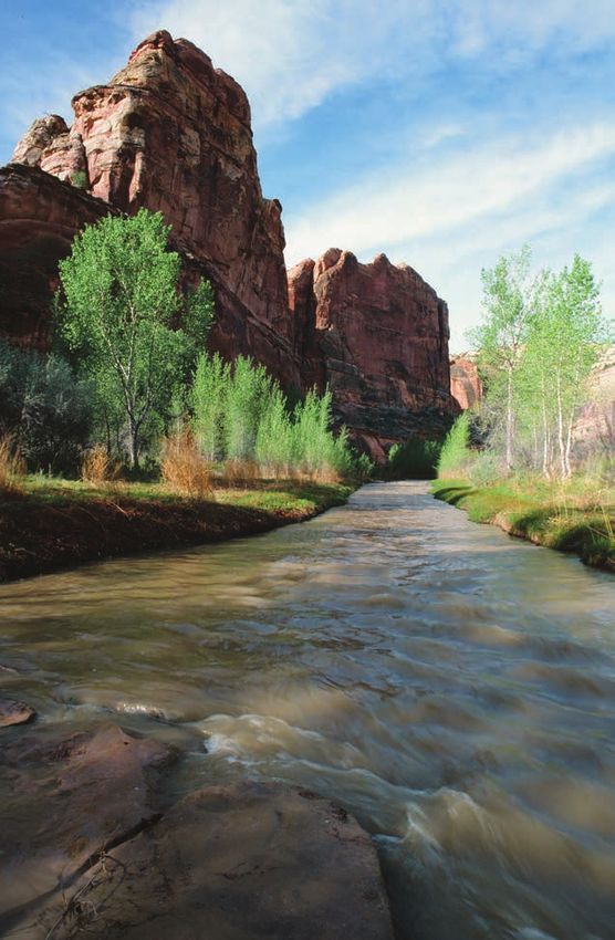
of the West.

Surveying Utah’s Great Rivers
   Centered in the great American desert that extends southward
from the Columbia basin to the Mexico border, Utah is the second-
driest state. Yet it still has 14,000 miles of perennial streams,
including some fine semi-natural waterways.
   With the fewest streams, the western portion of the state lies in the
Basin and Range geographic province and sits in the rain shadow of
both the Sierra Nevada and the high mountains of eastern Nevada.
This landscape is typified by long, thin, arid mountain ranges

                                                                                                                                                        TIM PALMER
interspersed with landlocked valleys that are isolated by seismic
activity that has given rise to the mountains surrounding them. In
these basins, ephemeral streams pool up and evaporate; many of
                                                                           Green River
Utah’s waterways never reach the ocean at all.
   A large block of the southern and southeastern state is part of the
Colorado Plateau. This is the archetypal desert landscape of red-rock      is the seventh-longest river in the U.S.—1,450 miles from Colorado
bluffs and table-top mesas along with sizeable intruded mountain           to the Gulf of California in Mexico. It enters Utah at its east-central
ranges, all incised by valleys and canyons of incomparable drylands        border and flows southwestward into redrock canyons; however,
grandeur.                                                                  half its length in Utah is impounded by Glen Canyon Dam.
    The northeastern portion of the state is part of the southern              The Colorado’s largest tributary, the Green River, is truly the artery
Rockies. Here the Wasatch and related mountains rise high for a            of Utah, flowing for much of its epic 730-mile length within the
north-south length 260 miles. Even higher, the Uinta Mountains             state. The Green features one of the longest free-flowing sections
lie on an unusual east-west alignment for 100 miles between the            of river in the West—and the longest that can reasonably be boated
Wasatch and the state of Colorado. All this high country catches           with rafts or other whitewater craft.
abundant snowfall feeding many small streams that flow down to                 Other sizable tributaries to the Colorado include the lower
the Great Salt Lake, the Green River, or the Colorado.                     Dolores as it flows from Colorado, and the San Juan as it enters Lake
   Utah’s large rivers all flow long distances from extensive              Powell from Colorado and New Mexico. Smaller and intermittent
mountain masses elsewhere. The Colorado, Green, White, Dolores,            tributaries to Utah’s lower Colorado have carved wild and seldom-
and San Juan gather their flows from the high peaks of the Rockies         visited but spectacular canyons: the Dirty Devil River with its Muddy
in Wyoming or Colorado before winding their way across Utah in             River headwaters, the Escalante of legendary red-rock beauty, and
an extravaganza of deep red-rock canyons that are the signature of         other smaller streams incised into multiple layers of sandstone.
Utah’s outstanding rivers estate.                                             The Uinta Mountains in the northeast corner of the state spawn
   The largest river in Utah is the Colorado. Carrying more water          a set of snowmelt-nourished streams that plunge through Rocky
than any other stream in the southern Rockies and Southwest, this          Mountain forests until they are dammed and diverted as they

                                                                                                                                                                     7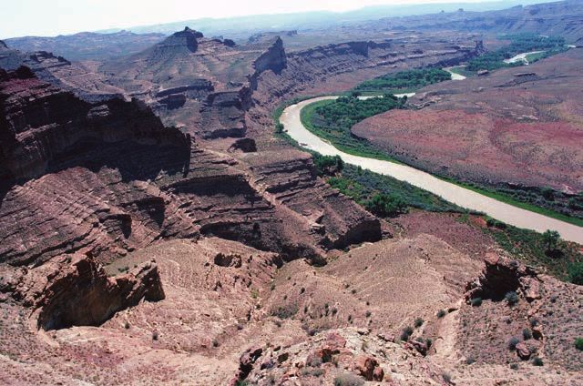
approach the Duchesne Valley. Streams of the Wasatch Front make Like elsewhere, only perhaps more so, the health of nature in Utah
even shorter, rapid plunges down the mountains but are quickly depends on the health of its rivers.
piped away to farms, and to Salt Lake City and its 100-mile-long Though this state has some rivers unlike any others, including
chain of suburbs. a few unquestionably extraordinary waterway routes, such as the
The Bear River takes one of the most roundabout river routes Green, and major recreational assets in waterways such as the
in America, rising on the north slope of the Uinta Mountains and Colorado and Virgin, not a single stream here has been protected
running north into Wyoming and Idaho, then looping back west in the National Wild and Scenic Rivers system. Nor is there any state
and south and finally emptying into the Great Salt Lake (60 percent system of protected rivers. The Utah congressional delegation
of the lake’s water comes from the Bear). Similarly blocked and has not supported the national program, though the Utah Rivers
redirected by the seismic uplifts in the central part of the state, Council works toward proposals that the organization hopes will
the Sevier River nearly encircles the Tushar Mountans to the south gain the backing of broad interests.
and the larger Pahvant Range to the north and terminates in the Like the rivers of the West overall, and especially similar to streams
landlocked, saline, Sevier Lake, which is nearly dry much of the time. in the other arid states of Nevada, Arizona, and New Mexico, the Utah
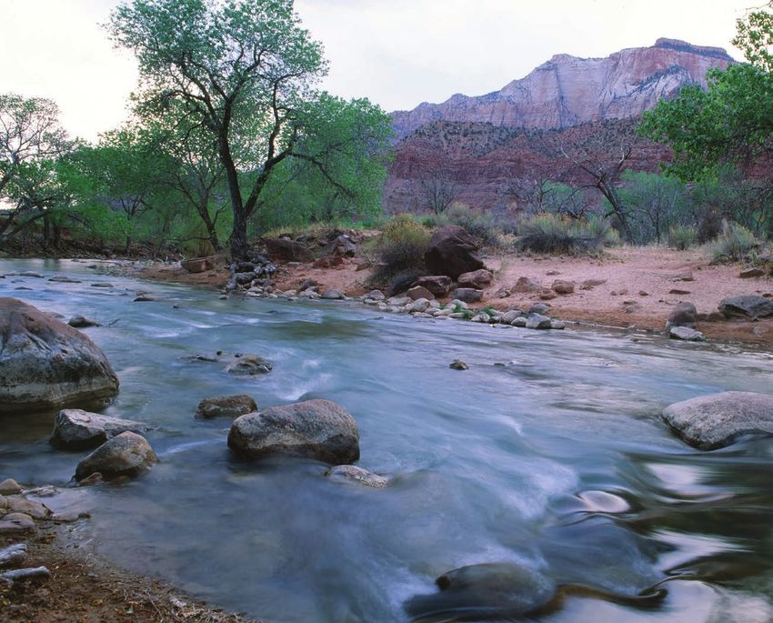
Finally, the 134-mile-long Virgin River is nourished by mountains rivers have almost universally been diminished by dams, diversions,
of southwestern Utah and cuts one of the most majestic canyons in and grazing in a region where watersheds are easily damaged.
the West through Zion National Park before being diverted in the St. This survey has identified only 12 river reaches exceeding 40 miles
George area and then flowing into Arizona and Nevada, ultimately that remain without dams and virtually without roads, though all
ending in Lake Mead—the reservoir formed by Boulder Dam on the these are affected by dams or diversions just up- or down-stream.
Colorado. The pressure for more water development will continue, and
Biologically impoverished compared to many other regions increase: Utah has the fourth-highest growth rate in the nation on a
of the West, the Utah rivers are limited owing to their naturally percentage basis, and demographers predict another million people
low, erratic, intermittent, and extremely turbid and warm flows, by the year 2020. With dams already restraining natural flood flows,
and even more to the severe demands that have been placed on floodplains and riverbanks downstream have been overrun by
them through damming and diversions. Four endangered fishes— tamarisk. Occupying roughly 90 percent of the floodplains here and
the Colorado pikeminnow, humpback chub, razorback sucker, in the rest of the Southwest, this exotic shrub has displaced native
and bonytail chub—migrate up and down large silty rivers and cottonwoods, willows, and other plants needed by wildlife (efforts
survive in the Green, Colorado, and lower White, as well as in some at biological control of tamarisk through an introduced insect hold
shorter, isolated reaches of river such as the lower San Juan. Not yet some promise). Even with these problems and others, a group of
endangered, but becoming rare, the flannelmouth sucker, bluehead remarkable rivers remains with substantial natural assets, and fine
sucker, and roundtail chub likewise long ago adapted to the extreme reaches of several large canyon rivers here are exceptional. g
conditions of the desert waterways and survive in isolated pockets
where the rivers have not been dammed or completely desiccated.
A few mountain streams still hold the rare Bonneville, Lahontan,
or Yellowstone cutthroat trout. The riparian corridors along large
and small rivers here are critical to some 70 percent of the birds and
other wildlife and represent rare greenery with trees and shrubs
in an otherwise extremely harsh landscape with spare vegetation.
8 Great Rivers of the West: UTAH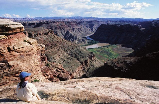
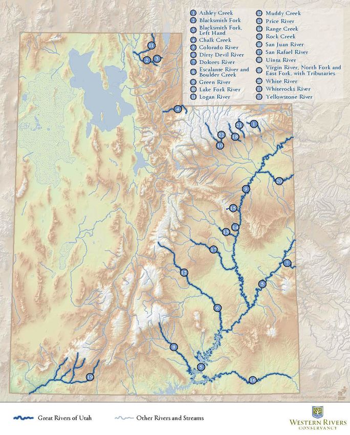
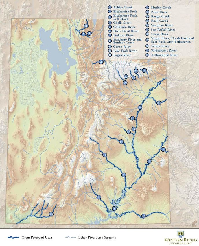
Utah’s Great Rivers: List

Utah’s Great Rivers:
     River Narratives
     UTAH’S “A” RIVERS

     Colorado River
        The Colorado River—myth-making, life-giving, rock-carving
     centerpiece to the entire southwestern region of the nation—flows
     through Utah in a series of deep and spectacular sandstone canyons
     with riparian corridors and habitat for endangered fish of the desert.
        The river enters Utah in the east-central part of the state through
     the closely linked Horsethief and Ruby Canyons, which extend 27
     miles with sandstone cliffs, distant mesas, and gentle riffles below
     Loma, Colorado. A railroad, but no road follows the river’s course
     here. The 17-mile Westwater Canyon follows, with narrow walls,

                                                                                                                                                TIM PALMER
     intense whitewater, and no road or trail access. Below Westwater,
     the river flows gently through more open tablelands for another 12
     miles of mostly roadless riverfront and then for 35 riffling miles with   Colorado River in Cataract Canyon
     Highway 128 running alongside, all through spectacular redrock
     canyonlands to the town of Moab. Then, the Colorado continues for
                                                                               canyon complexes of the West—dam-free, with long reaches
     another 15 miles of still water with Highway 279 alongside, until that
                                                                               lacking roads or development of any kind. The endangered warm-
     road dead-ends at a phosphate plant. From that point downstream,
                                                                               water fish of the Colorado basin survive here, with Ruby and
     the river flows for 67 wilderness miles through some of the grandest
                                                                               Horsethief Canyons having one of the healthiest populations of the
     canyon country of the West, including Cataract Canyon with its 12-
                                                                               Colorado pikeminnow. Riparian forests of cottonwoods, tributary
     mile reach of big whitewater, before hitting the backwater of Lake
                                                                               streams with narrow and enchanting passages, and long reaches
     Powell. The rest of the Colorado’s path through Utah is flooded by
                                                                               of both superb whitewater and also gentle-gradient boating are
     the reservoir, whose tentacles also reach up many tributaries.
                                                                               all found here. Along with sections of the Green River in its twin
       Though the Grand Canyon is yet to come in Arizona, the                  path southward through the Colorado Plateau of eastern Utah, the
     Colorado’s route of 176 miles from the beginning of Horsethief            Colorado River offers the nation’s most awesome flatwater paddling
     Canyon to the Powell reservoir backwater is one of the great              in deep desert canyonlands with monumental geologic features

10   Great Rivers of the West: UTAH
exposed throughout. These include sandstone walls at Colorado 56-mile-long wilderness reach through the narrow and tightly
National Monument on the south shore below Loma, Fisher Towers linked Lodore, Whirlpool, and Split Mountain Canyons, all within
and striking canyon walls along Arches National Park above Moab, Dinosaur National Monument. Below there, the Green flows for a 96-
and the massive cliffs of Canyonlands National Park in the lower end mile respite of gentle water past desert wetlands of Ouray National
of the free-flowing reach of the river. Sandstone rims of the canyons Wildlife Refuge and through the Uintah Ouray Indian Reservation
reach up to 2,000 vertical feet in places such as Dead Horse Point to enter the starkly beautiful Desolation and Grays Canyons, which
State Park, downstream from Moab. Westwater Canyon includes continue for 87 miles before breaking out of the Bookcliff Plateau
big-water boating challenges, and Cataract Canyon includes rapids near the town of Green River. The river’s final 139 miles flow gently
that in high water rival those of the Grand Canyon. through Labyrinth and Stillwater Canyons, to the confluence with
Most floodplains of the Colorado River and its tributaries are now the Colorado in the heart of Canyonlands National Park. From
covered by the invasive exotic shrub, tamarisk, which diminishes here, the combined Green and Colorado cavort in 18 miles of big
or totally eliminates the rich riparian habitat provided by the whitewater before ending in the backwater of Lake Powell, giving
native cottonwood and willow community. There is hope that an the Green-Colorado Rivers a continuous free-flowing length of 443
introduced beetle will reduce this invasive shrub and allow native miles—slightly longer than the Salmon-Snake combination of free-
plantlife and its related species of birds and other fauna to thrive flowing, boatable whitewater in Idaho.
once again. Because there is a dearth of runoff across the river’s desert
Most of the Colorado River corridor is public land under the route, and because almost all the region’s water comes via larger
management of BLM or the National Park Service (Arches and rivers from far away, the mighty Green River has only a few major
Canyonlands National Parks), though large tracts of private land tributaries. The Yampa and White Rivers are listed and described in
are also located here, especially in Ruby and Horsethief Canyons the Colorado chapter.
and in the reach between Westwater Canyon and Moab, which is
now experiencing intense development pressures associated with
growth in the Moab vicinity.
Green River
Exceeding even the Colorado in grandeur, length, and wildness,
the Green is the major artery of Utah, and most of its phenomenal
425-mile free-flowing reach slices through the high plateaus and
canyonlands of the eastern part of the state (a 40-mile section arcs
through northwestern Colorado).
After beginning in wild mountains of Wyoming (see the Wyoming
section of this report), the Green reaches Utah within a 65-mile-
long reservoir; Flaming Gorge Dam in far northeastern corner of the
TIM PALMER
state is the lower of two major dams on the Green. Below it, the river
flows clear and cold for 47-miles through the Flaming Gorge and
Brown’s Park National Wildlife Refuges. Then it enters a spectacular Green River below Flaming Gorge Dam
11A few other notable, but small, tributaries enter in Desolation
Canyon; these include Rock Creek, Range Creek, and the Price River
(see C Rivers), all of which drop from high elevation tablelands,
through remote canyons with perennial flows and lush riparian
corridors.
Downstream from the Yampa confluence in Dinosaur National
Monument, the Green supports the endangered Colorado warm-
water fishes. Above that point the flow manipulations of Flaming
Gorge Dam have made the river inhospitable to native fish and have
instead favored introduced trout in a cold-water, tailrace fishery
below the dam, which has attained a national reputation as a an
excellent “blue ribbon” sport fishery with up to 20,000 trout per mile.
JACQUELINE OLEXA
Throughout its free-flowing length, the cliffs, wilderness tributary
canyons, whitewater, lush riparian forests at the mouths of side
streams, Indian pictograph sites, and wildlife habitat all combine to
make the Green River exceptional in the West. Highlights include the Virgin River, Zion Narrows
deep, narrow canyon of Lodore, the enchanting confluence where
the Yampa joins in Echo Park, the one-of-a-kind bisection of Split
Mountain in Dinosaur National Monument, the 100-mile flatwater in the Jensen area, and upstream for 10 miles from the town of
reach with riparian wetlands downstream, the 85-mile wilderness Green River. However, perhaps the greatest threat to the Green
canyon of Desolation, and the sheer-walled canyons of Labyrinth River looms with potential for development and expansion of oil
and Stillwater before the Green joins the Colorado within the rock- and gas drilling and also oil extraction from shale that is abundant
walled fastness of Canyonlands National Park. in areas managed by the BLM.
When paired with the Yampa and its tributaries, the Green River
system offers the longest continuous free-flowing mileage in the Virgin River, North Fork and East Fork, with Deep
West. The Green likewise has some of the longest essentially roadless Creek, Crystal Creek, North Creek and its Right and
riverfront in the West, with a reach of 107 miles below Ouray, 156
Left Forks, La Verkin Creek, and the upper main stem
miles from Green River to the backwater of Lake Powell, and 45
miles through Dinosaur National Monument. The river sections
Virgin
downstream from the towns of Ouray and Green River are two of The outstanding streams of the upper Virgin River basin cut
the longest in the West uncrossed by a bridge. through stunning canyons in Zion National Park—sometimes
Most of the Green River corridor is public land managed by called a “red-rock Yosemite”—and comprise the major river system
BLM, the National Park Service, the Fish and Wildlife Service draining southwestern Utah.
within national wildlife refuges, and the Uinta and Ouray Indian Gathering waters on the 8,800-foot high Pink Cliffs Plateau, the
Reservation. Scattered private tracts, however, do appear in several North Fork Virgin begins by tumbling 1,000 feet in a 12-mile reach
sections, and significant reaches of private land are found between through private and BLM land to the boundary of Zion National
Dinosaur National Park and the Uinta and Ouray Indian Reservation Park. The stream then flows for 20 miles through the park, with road
12 Great Rivers of the West: UTAHaccess along the lower two-thirds of this reach, to the confluence Fork is a wilderness canyon noted for unique geological formations.
with the East Fork, where the main stem begins. The lower 7 miles of North Creek flow largely through private land
The East Fork likewise begins on a high plateau, drops into Long mixed with BLM acreage.
Valley where it flows for about 25 miles with Highway 89 running Eight miles downstream from the North Creek confluence, the
alongside, and then enters a deepening, roadless canyon where main stem Virgin picks up La Verkin Creek, which flows in from the
it flows 10 miles to the national park boundary. It continues for 5 north after dropping for 12 miles from wild recesses above and
roadless miles through the park, followed by 2 miles through private within Zion National Park and then for another 15 miles through
land, to join the North Fork. lower wilderness canyons managed mostly by BLM, but with several
The North Fork Virgin in Zion National Park is one of the more state and privately owned tracts as well. This “branch” of the Virgin
remarkable small rivers of the region. After picking up the 16- is even wilder than the others because it is roadless except for a
mile roadless and dam-free Deep Creek, along with its tributary, few miles of unimproved access in its lower reach. Virgin spinedace,
the similarly wild 10-mile-long Crystal Creek, the North Fork flows speckled dace, and desert suckers—imperiled native fish—survive
through “The Narrows”—an extended, slot-canyon as little as 18 here.
feet wide at its bottom but with red-rock sandstone walls soaring The upper main stem Virgin supports the imperiled Virgin River
2,000 feet upward. The Narrows can be waded and walked in low spinedace, which is also present in some of the tributaries.
water—a one-of-a-kind river hike in the West, though flash-floods Seven miles downstream from La Verkin Creek, the main stem
can be a consequential hazard. With their continuous mileage, Virgin encounters Quail Creek Reservoir, an off-stream impoundment
the Deep Creek-North Fork and Crystal Creek-Deep Creek-North supplied by water diverted from the river. Below this point, the river
Fork combinations each offer an 18-mile roadless reach of wild is severely depleted of its flow and enters the heavily urbanizing
streamfront that is spectacular and remote. From the mouth of the
Virgin River Narrows, the Zion National Park road follows the North
Fork downstream as it winds through spectacular canyon scenery
with cottonwood trees on flood plains and cliffs rising to towering
heights of 1,000 and 2,000 feet. Two low diversion dams are located
on the lower river before its confluence with the East Fork.
The East Fork of the Virgin begins with a long road-accessible
reach through private land, followed by a striking, inaccessible
canyon. The short reach that flows within Zion National Park is a
designated research natural area with access restricted for scientific
purposes.
The main stem Virgin was once one of the truly great rivers of
the desert southwest. From the confluence of the North and East
FLICKR/MARTIN MALE
Forks, it flows for 8 miles with Highway 9 alongside, and then picks
of the flows of North Creek. This 18-mile tributary runs from the
western side of Zion National Park with roadless upper reaches in its
Right and Left Forks. The Right Fork is regarded as one of the most
adventurous and rugged backcountry hikes in the park; the Left Virgin River
13St. George area. Native warm-water fishes once thrived in the main
stem but are now depleted or extinct from major sections of the
river. Though Interstate 15, other highways, urban development,
and diversions affect the river, the Nationwide Rivers Inventory still
lists the lower main stem as supporting the endangered woundfin
minnow, Virgin River chub, and a variety of bird and mammal
species.
The Zion complex of Virgin River tributaries remains the only
vestige of natural streams left in southwestern Utah and stands
as one of the most spectacular sets of red-rock canyon streams in
the Southwest. The entire watershed is threatened by recurrent
proposals for dams and diversions above the national park and on
tributaries including North Creek to serve the booming St. George
urban area.
White River
This major tributary to the Green River supports endangered
warm-water fishes and flows undammed and nearly roadless for
all of its distance in Utah and has a cottonwood corridor along
the shores. Though oil and gas development has affected the
watershed, and the river’s riparian corridor is often lean, the river
is still exceptional in its long free-flowing reach and undeveloped
and roadless character. See the Colorado section of this report for a
more complete discussion of this important river.
UTAH’S “B” RIVERS
Escalante River and Boulder Creek
This amazing tributary of the Colorado flows from high mountain
plateaus down to deep desert canyons, with cottonwood groves,
TIM PALMER
mazes of entrenched meanders, and towering vertical walls.
The river corridor offers habitat to bald eagles and potentially to Escalante River
peregrine falcons and Mexican spotted owls.
14 Great Rivers of the West: UTAHThe Escalante River begins about eight miles northwest of the
town of Escalante, collecting waters from roaded tributaries that
start high on the 10,000-foot, conifer-clad Aquarius Plateau. Much
of this flow is diverted for irrigation, but east of town, the river
drops for 12 roadless miles through a spectacular canyon, where its
flows are restored by significant tributaries, including Pine, Death
Hollow, and Calf Creeks. This wild stretch is reachable by a trail from
Calf Creek Recreation Area where Highway 12 crosses the river.
From there to the backwater of Lake Powell near Coyote Gulch,
the Escalante flows dam-free through a twisting wilderness of red-
rock canyons in Grand Staircase Escalante National Monument and
then Glen Canyon National Recreation Area. The principal, and best
source of the river is Boulder Creek and its West Fork, a 25-mile-long
stream that remains less affected by diversions and development
than other Escalante sources. Most of its length has no roads nearby.
CHAD SAUNDERS
Unlike many other tributaries to the Colorado in southern Utah,
the Escalante is almost always wet at least in pools. Dozens of
tributaries join the river; many of them with magnificent narrow slot Logan River
canyons.
Hikers explore the wild canyon when flows are low, typically from
decades, but designation of Grand Staircase Escalante National
late March through June and mid-September through October.
Monument in 1996 led to retirement of grazing permits in the river
Even at these low-water times, much wading is required. In years
corridor in 1999, and the effects of cattle are largely limited to herds
with ample precipitation, whitewater boaters may find a narrow
crossing the river en route to other grazing areas. Owing to rock
window of opportunity in spring to negotiate the route with some
barriers, cattle have never been able to reach and degrade the lower
rapids and minor portaging.
20 miles.
The Escalante’s upper tributaries (North, Pine and Boulder Creeks)
Before the filling of Lake Powell, the lower Escalante was
are home to Colorado River cutthroat trout, and the Boulder River
considered one of the most sublime of all desert canyons with
system is especially productive. According to the Nationwide Rivers
its massive walls, narrow depths, and abundance of intricate side
Inventory, bald eagles use the lower canyon, and the river corridor
canyons.
offers potential habitat for peregrine falcons, mountain lions, and
Mexican spotted owls. With 70 free-flowing miles, the Calf Creek-
Coyote Gulch reach appears to be the fourth-longest roadless and Logan River
dam-free section of river in Utah, behind two sections of the Green,
and the Dirty Devil River. Along with the North Fork of the Virgin, the This scenic, popular recreation river east of Logan is the best
Escalante is one of the premier narrow, scenic, wilderness canyons stream for Bonneville cutthroat trout in Utah and probably the
for paddling and hiking. second best in the three-state area where these native fish occur.
Cattle have roamed freely through much of the canyon for Beginning in southern Idaho, the Logan drops quickly into
15Utah and flows 7 miles with the lightly traveled Forest Service
Route 006 in its valley before encountering Highway 89. With this
busy highway alongside, the river drops steeply for 22 more miles
through beautiful Rocky Mountain country with a lush willowed
riparian zone to the mouth of its canyon, and then winds through
the city of Logan and the agricultural Cache Valley to the Little Bear
River. The river is unregulated by storage reservoirs, though there is
a small hydro project just upstream from the canyon mouth.
Flowing through karst, limestone terrain, the Logan has a
particularly productive fishery and is a favorite of many trout
anglers. But more important to this survey, it is the finest remaining
Utah stream for native Bonneville cutthroat trout, which have been
extirpated from all but 30 percent of their native range. This may be
the largest population in the state, and the river system is one of
the two longest that is still suitable to this widely migrating fish (the
JESSE VARNER
best among all Bonneville cutthroat streams is the Smiths Fork of
the Bear River; see the Wyoming section of this report). Headwater
basins of the main stem Logan—Spawn Creek, Beaver Creek, and
San Juan River
other tributaries—are vital spawning grounds for this fish that lives
in the main stem for much of its life but migrates upstream to spawn
in small tributaries. While many of the current Bonneville cutthroat pikeminnow.
populations elsewhere survive only in isolated fragments of stream
From Woodside (south of Price) on Highway 6 to the Green River,
where habitat has not been degraded and where non-native fish
the Price flows 23 miles through the uplifted sandstone formations
have not been introduced—such as a short section of Red Butte
of the Beckwith Plateau. A 4-wheel-drive road follows near the river
Creek above the University of Utah in Salt Lake City— two larger
for the first 6 miles of this reach; after that, the route is completely
stream systems remain where these native fish are doing well: the
roadless as the river twists through its canyon in Class II and III
Logan and Weber Rivers. With more suitable habitat remaining, the
rapids. A BLM wilderness study area, the canyon supports mountain
Logan is the best of these. This river also has a popular whitewater
lions and other wildlife in a corridor linking the wildlands east of the
boating run.
Wasatch Plateau with the extensive wilderness of the Green River’s
Desolation-Grays Canyon complex.
Price River, lower
The Price River is the largest tributary to the Green within Rock Creek and Range Creek (Green River tributaries
its Desolation-Grays Canyon reach. Though heavily affected in in Desolation Canyon)
upper reaches by the city of Price, by mining, by industry, and by
roads, the lower river has a fine riparian corridor in a long roadless These two perennial streams are excellent tributaries to the Green
reach, including 35 miles that support the endangered Colorado River within Desolation Canyon, the second-longest essentially
roadless reach of river in Utah. Flowing from the 10,000 foot West
16 Great Rivers of the West: UTAHTavaputs Plateau and Roan Cliffs, these creeks drop 4,000 feet
through remote aspen-clad mountain terrain and then sagebrush-
studded desert canyons to join the Green.
Rock Creek has a healthy year-round flow of crystal-clear water in
a region where almost all streams are intermittent and silty. Spring-
fed, it flows with far more water than any other Desolation tributary
except the Price River, even though Rock Creek is only 8 miles long.
The roadless watershed features a lush riparian corridor of willows.
Range Creek is a 36-mile-long tributary to the Green. An
unimproved road follows much of its length, and a private ranch is
located along its mid-section. Its elevation spans from a spruce and
fir belt at its upper end to lush cottonwoods in its lower reaches.
The Nationwide Rivers Inventory lists golden eagles and peregrine
falcons as residents here.
San Juan River, lower
The lower 84 miles of this 400-mile-long river offer an exceptional
desert and canyon waterway with small rapids, entrenched
meanders 1,000 feet deep, and wilderness country with rugged side
canyons.
The San Juan begins in highcountry of the Weminuche
Wilderness in the southern Rockies of Colorado, flows through the
town of Pagosa Springs, and backs-up in the massive impoundment
of Navajo Reservoir at the New Mexico state line. Heavily developed,
diverted, farmed, and urbanized, it passes through the city of
Farmington and then through Shiprock on the Navajo Indian
Reservation. The heavily depleted river enters Utah and is riddled
with roads and oil wells to the small community of Bluff, where
its face is suddenly changed as it drops into an exquisite canyon
complex that continues for 84 miles to the backwater of Lake
Powell. The San Juan is the third-largest tributary to the Colorado
River, after the Green and Gunnison.
Below Bluff, the river flows for a 28-mile-long roadless reach to
TIM PALMER
Mexican Hat, where Highway 261 crosses the river on a high bridge,
though there is an access ramp. The river then proceeds through Ashley Creek
17stark, wild canyons for 56-miles to the backwater of Lake Powell,
where an unimproved road at Clay Hills offers access.
These two reaches of the San Juan include moderate rapids,
exceptional rock art and Indian ruins, and excellent desert hiking. In
the lower reach, spectacular tributary canyons, including Slickhorn
and Grand Gulch, enter from the north side. Canyon walls rise in
multiple layers of sandstone and shale, and the Honaker Trail climbs
1,500 feet up to the rim to overlook the “Goosenecks” section,
a tightly looping series of meanders where the river is deeply
entrenched in the Monument Upwarp of the Colorado Plateau. The
two adjacent roadless reaches of the San Juan have a combined
length of 84 miles.
The lower San Juan is habitat to all four endangered warm-
water fishes of the Colorado basin, though the razorback sucker is
especially rare. Peregrine falcons and bald and golden eagles live
here. Like other Colorado tributaries, the banks of the San Juan are
crowded with exotic tamarisk.
In Utah, nearly the entire river flows through BLM, Navajo
Reservation, or Glen Canyon National Recreation Area lands.
Uinta Mountain Rivers: Uinta River, Ashley Creek,
Whiterocks River, Yellowstone River, and Lake Fork
River
Five outstanding small rivers flow from the south side of
the 130-mile-long Uinta Mountains, a high, rounded, often-
snowcapped range that lies in an unusual east-west alignment
across northeastern Utah. Together, these streams are the finest
of Utah’s mountain waterways, each flowing from highcountry
and dropping into deeply forested valleys and canyons carved by
glaciers. Typically roadless in their upper reaches, they are reached
TIM PALMER
by lightly traveled, dead-end roads and then trails approaching
from the south. All these streams are diverted for irrigation or water
supply as soon as they leave the mountains (or before). In contrast, Whiterocks River
the north-side streams of the Uintas have shorter roadless reaches
and drop more quickly off the mountain slopes to a high and dry
18 Great Rivers of the West: UTAHplateau terrain. The following descriptions of the south-side streams 200-foot-high dam as part of the Bureau of Reclamation’s Central
are ordered from west-to-east. Utah Project. The Ute Tribe has thus far not allowed this project to
On the western reaches of the Uinta Mountains, the North Fork proceed.
Duchesne has been depleted by a major diversion tunnel even at a The Whiterocks River has road access via Forest Service Route
high elevation, and the adjacent stream, Rock Creek, has likewise 110 to its source in Chepeta Lake, which lies beneath high rolling
been diverted. But the next stream to the east, Lake Fork River, peaks on the Uinta crest, but then it flows for 13 miles through a
begins near the 13,219 feet high Mount Lovenia in the High Uintas deep mountain canyon without road or trail access. Then the river
Wilderness and flows for about 15 miles with trail access down to flows for 8 miles alongside Forest Service Route 492 to the mouth
the backwater of Moon Lake Reservoir. Below the dam, another 8 of the canyon where the river is diverted. The river canyon provides
miles of road-accessible river are boated by whitewater paddlers in excellent habitat for wildlife including bighorn sheep, moose,
June or late spring. Then a diversion dam shunts most of the river’s elk, and others, and its tributary, Reader Creek, is habitat for the
flow into the Farnsworth Canal for irrigation below. Colorado River cutthroat trout and has been an important stream
The Yellowstone River, with its upper extension of Yellowstone for the reintroduction of this native species.
Creek, flows from the Uinta crest at Kings Peak, Utah’s highest Finally, the easternmost of the relatively natural Uinta streams is
summit at 13,512, also in the High Uintas Wilderness. It drops Ashley Creek. Its South Fork begins on the south slope of Leidy Peak
through a deep glaciated valley with trail access for 15 miles to and flows about 14 miles with trails alongside and only one remote
the end of Forest Service Route 124, and then continues another 4 road-crossing down to the North Fork confluence. The main stem
miles to a dam. Below the dam, the river flows 8 more miles through then flows for another 12 miles through a deep mountain canyon
an opening valley and then is heavily diverted. With spectacular before roads appear and diversions begin.
scenery, waterfalls, and cascades, the river is an important wildlife Among these 6 streams, the Uinta River appears to have the
corridor and is one of few streams in the state with a genetically longest roadless mileage (20) and the longest dam-and diversion-
pure strain of Colorado River cutthroat trout. A proposed 200-foot- free length (25 miles).
high Bureau of Reclamation dam is slated to impound a currently
free-flowing reach of this river, but has been thus-far been stopped
owing to opposition by Indians and others.
The Uinta River runs for about 20 miles from its high, rocky, UTAH’S “C” RIVERS
meadowland source of Gilbert Creek near Gilbert Peak, which rises
to 13,442 feet (Kings Peak also drains into this river) in the High Blacksmith Fork and Left Hand Fork Blacksmith Fork
Uintas Wilderness. The stream passes through a deep, glaciated
valley with trail access to the end of Forest Service Route 118. The Dropping in rugged mountain canyons through paralleling sub-
river flows another 5 miles with road access to a diversion dam ranges that lie to the northeast of the Great Salt Lake, these two
that blocks the flow several miles above a power plant. Below relatively undeveloped tributaries to the Little Bear River are among
there, other diversion dams take most of the river’s water. The river the best streams flowing from the west slope of the southern
supports native whitefish, mountain suckers, speckled dace, long Rockies—from the Wasatch and related subranges that extend
nosed dace, and Colorado River cutthroat trout, along with a superb through the northern two-thirds of Utah.
wildlife corridor. The Blacksmith Fork begins near Red Spur Mountain in the
Like the Yellowstone, the Uinta River is threatened by a proposed Monte Cristo Range and drops precipitously for about five roadless
19give rise to most of Utah’s rivers not coming from outside the state,
few streams of high quality remain along this impressive mountain
front. Nearly all are encroached on by roads, blocked by dams for
water supply and hydroelectric power, and heavily developed
by ski resorts at their upper ends along with intensely urbanizing
corridors in low elevations. Though far from wild, the Blacksmith
Fork and its Left Fork tributary are among the least affected streams
on this mountain front.
Chalk Creek, with South Fork and Mill Fork
Chalk Creek and its major tributaries are one of the most
FLICKR/TAMRA HAYES
important stream systems for the rare Bonneville Cutthroat trout,
with more than 100 interconnected miles of habitat.
Starting near the Utah-Wyoming border, this stream flows about
Dirty Devil River 32 miles west to the Weber River. Highway 133 follows along most
of the stream’s length. Bonneville cutthroat trout range throughout
the river system, but tributaries Mill Fork and South Fork, which
miles to Ant Valley. After flowing four miles through gentler, ranch drain the northern end of the Wasatch Range, offer particularly
land terrain, it meets state Highway 101 and drops steeply again for good cutthroat habitat. Much of the main stem winds through a
eight miles through the Bear River Range to the confluence with the valley with ranchland and with forests on the mountain slopes.
Left Hand Fork. After another four miles, the small stream reaches Canoeists use the lower river from the South Fork down, which has
the mouth of its canyon at the base of the mountains and then mostly a gentle flow except for one mile of Class II whitewater. Most
winds through the suburbanizing Cache Valley, south of Logan, to of the stream valley and frontage is privately owned.
the Little Bear River.
Wilder than the main fork, the Left Hand Fork of Blacksmith
starts in the high basin of Strawberry Valley and plunges for 14 Dirty Devil River and Muddy Creek
miles through the Wasatch-Cache National Forest to its confluence
with the Blacksmith Fork. A lightly traveled road and several Among the most remote, long reaches of river in Utah, the Dirty
campgrounds are located along the wooded stream. Both forks Devil and its upriver extension of Muddy Creek are extensive and
are noted trout fisheries and support native whitefish as well as essentially roadless, dam-free rivers with spectacular canyons and
Bonneville cutthroat trout. Remnant populations of native mountain some of the least-visited riverfront in the greater Southwestern
suckers, and longnose dace can also be found here. desert region.
Even though the Bear River-Wasatch-Fish Lake Mountains Beginning on the Wasatch Plateau in the Manti-La Sal National
comprise the north-south backbone of the southern Rockies for Forest west of Ferron, Muddy Creek flows southeast through pine-
260 miles in Utah, and collect the greatest amount of snow, and clad canyons for 16 miles to Highway 10, and then 12 miles across
an agricultural valley to Interstate 70, where it enters a 48-mile,
20 Great Rivers of the West: UTAHenters the spectacular Robber’s Roost Canyon and flows through
a maze of rocky country to the backwaters of Lake Powell. Only
one unimproved road comes down to the river in this remote 74-
mile reach. In early June of a wet year, the river offers Class I and II
paddling. Side canyons formed by flash floods offer beautiful hiking
opportunities. Peak flows on this stream, which often dries up in the
summer and leaves just lingering flatwater pools—was 35,000 cfs in
1957; flash floods can transform the Dirty Devil into an equivalent of
the Grand Canyon of the Colorado.
Combined, the 98-mile-long Muddy Creek and 74-mile-long
Dirty Devil form a continuous undammed route of 172 miles. An
84-mile reach of Muddy Creek and 74-mile section of the Dirty
Devil are also essentially roadless, with just a few unimproved dirt
roads coming close to the river. With canyons 300-900 feet deep,
the Dirty Devil corridor supports golden eagles and peregrine
falcons. The uppermost reaches of tributaries support a population
of Colorado cutthroat trout, while the lower river offers habitat
for endangered razorback suckers as well as other imperiled fish
Dolores River
including flannelmouth suckers, bluehead suckers, speckled dace,
and roundtail chubs.
wild canyon that cuts through the uplift of the San Rafael Reef. The Muddy Creek and the Dirty Devil are similar in some ways to the
river carves into various layers of sandstone and flows through a better-known Escalante River—another north-side tributary to the
box canyon known as the Chute; in one place, walls narrow to a Colorado in its flooded reach behind Glen Canyon Dam. The Muddy
7-foot-wide slot within a 300-foot-deep chasm with overhangs that Creek-Dirty Devil reach, however, is longer, and more remote.
block the sky from view. One unimproved dirt road reaches the
river about 28 miles downstream from I-70, and another comes in
20 miles farther downstream and then parallels the creek for about Dolores River
six miles. Muddy Creek then runs roadless for its final 22 miles to
the town of Hanksville, where it joins with the greater flow of the The lower end of this important Colorado River tributary flows
Fremont River to form the Dirty Devil River. Whitewater guidebook through Utah. If McPhee Dam did not divert such large amounts of
author Gary Nichols calls Muddy Creek a “truly outstanding desert water, the Dolores would be one of the finest rivers of the Colorado
river,” referring to its “incredible scenery, isolation, and numerous Plateau. See the Colorado section for a description of this river.
rapids.” In May or June of a wet year, the creek runs high enough
to float whitewater boats, however, much of the time the canyon
remains mostly dry. San Rafael River
After flowing for about 15 miles through open desert terrain This remote, undammed, often dry, and largely roadless river
below the Muddy Creek-Fremont River confluence, the Dirty Devil flows through spectacular canyon country as it cuts through the
21San Rafael Swell of dramatically uplifted sandstone and as it drifts
across desert valleys on its way to the Green River.
The San Rafael begins at the confluence of Ferron, Cottonwood,
and Huntington Creeks, which drain runoff from 11,000-foot
peaks into the well-settled Castle Valley, southwest of Price. The
river soon enters a spectacular canyon that twists through the
massive sandstone uplift of the San Rafael Swell. In places, sheer
walls overhang the swift river, and at the “Black Box,” the stream
drops through steep rapids and small waterfalls. The river almost
completely encircles the cone of Mexican Mountain, before it drops
steeply again through the San Rafael Reef, another uplift of rock.
Then it meanders through lowlands to the Interstate 70 crossing. In
another eight miles, Highway 24 crosses the San Rafael. From there,
the river runs for about 36 miles, first through private ranchland
with only unimproved road access and then through BLM canyon
TIM PALMER
county to the Green River.
The Nationwide Rivers Inventory makes note of the San Rafael’s
deeply entrenched canyons, scenic sandstone formations, excellent San Juan River
hiking opportunities, unique geology, archaeological sites, and
golden eagle habitat, and guidebook author Gary Nichols refers
to the canyons’ “indescribable beauty.” The entire river length of
about 110 miles has no dams and little road access. Yet the river is
heavily diverted at its headwaters, and usually has little or no water
in its channel. Even then, it remains an important wildlife migration
corridor. Lower reaches with perennial flows support the native
Colorado pikeminnow, round-tail chub, speckled dace, flathead
minnow, red shiner, flannel mouth sucker, and bullhead sucker.
The biology of the river has been much degraded even within
the past few decades. Native warm-water fishes, including roundtail
chub, bluehead sucker, flannelmouth sucker, and Colorado
pikeminnow were present in the San Rafael River system in the
late 1970s but since then have been extirpated owing to depleted
flows. Vegetation along much of the stream includes large thicket
of tamarisk. g
22 Great Rivers of the West: UTAHConclusion
U
sing 15 lists of high quality rivers compiled by other groups
or by agencies, we found 132 Utah rivers that were noted
for natural values. With further analysis and drawing upon
interviews with local experts, we sorted these streams into an A list
of 12 rivers and tributaries, a B list of 12, and a C list of nine. The
following clusters of high-ranking natural rivers became evident.
Colorado-Green-White system, for endangered fish
A significant complex of contiguous, undammed river reaches
in the Colorado River Basin offers the best remaining habitat for
endangered and imperiled warm water fishes—the Colorado
pikeminnow, humpback chub, razorback sucker, and bonytail chub.
TIM PALMER
These reaches include the Colorado River from the mouth of the
Gunnison River (in Colorado) down to the backwater of Lake Powell,
Green River
the Green River from the mouth of the Yampa (in Colorado) to its
confluence with the Colorado, and the White River from Taylor Draw
Dam to its Green River confluence. The lower Price River could also forest mountain plateaus to redrock canyonlands, the stellar East
be included in this group. This suite of rivers is also exceptional Fork, the North Fork with its tributaries of Deep and Crystal Creeks,
for its spectacular redrock canyons through the Colorado Plateau North Creek with its Left and Right Forks, and La Verkin Creek all flow
geologic province, its length of long undammed and mostly as excellent streams in adjacent, parallel valleys before joining to
roadless riverfront, and its incomparable scenery and recreational form the Virgin. Few desert river systems combine such spectacular
opportunities, including long river trips uninterrupted by dams or scenery with perennial flows and dam-free, roadless mileage. Some
significant development. Much of the land in these river corridors of the upper Virgin’s mileage is protected in Zion National Park,
are publicly owned, but large areas and many scattered parcels are but much of it is threatened by water supply proposals from the
also privately held. urbanizing St. George area, just downstream.
Upper Virgin River system Dirty Devil system
The upper Virgin River with its Zion National Park tributaries In the incredibly inhospitable desert lands at the southcentral
stands as the exemplary river system of southwestern Utah. From part of the state, the Dirty Devil River with its upriver extension of
23You can also read