2019-20 BIKING GUIDE exploreminnesota.com - Explore Minnesota
←
→
Page content transcription
If your browser does not render page correctly, please read the page content below
exploreminnesota.com

                       2019-20 BIKING GUIDE
e xploreminnesota .c om B-1
BIKE
                                                                                exploreminnesota.com

                                                                                                                     2019-20 BIKING GUIDE

                                                                                                             EDITOR
                                                                     uth of
                                            Located just an hour so
                                                                                                           Brian Fanelli

                                                                      fun &
                                           the Twin Cities, create a                          COMMUNICATIONS MANAGER
                                                                        ring
                                            memorable getaway explo                                        Erica Wacker

                                                                      right
                                             the beauty of the bluffs                                  GRAPHIC DESIGNER
                                                                         r
                                               on the Mississippi Rive                                    Melanie Graves

                                                                                                       BUSINESS OFFICE
                                                                                                 121 Seventh Place E., Suite 360

                                              Mountain Biking at                                       St. Paul, MN 55101

                                               Welch Village
                                               Mountain Bike Park
                                                                                                         PRODUCED BY
                                                                                             GREENSPRING MEDIA, LLC
                                                                       ERS
                                              MODERATE TO ADVANCED RID
                                                                                                           PUBLISHER
                                                                                                           Tammy Galvin

                                                                                          EXECUTIVE DIRECTOR OF CONTENT
                                                                                                            Mike Berger

             19.7 Paved Miles on
                                                                                                 SALES REPRESENTATIVES
                                                                                       Craig Dormanen, Sue Fuller, Kristin Gantman

              Cannon Valley Trail                                                                            EDITOR
                          FOR ALL RIDERS                                                                   Claire Noack

                                                                                                         ART DIRECTOR
                                                                                                          Sommer Stelzer

                                                                                                   PRODUCTION MANAGER
                                                                                                           Cindy Marking

                                                 Mountain Biking at                             AD TRAFFIC COORDINATOR

                                                  Memorial Park                                          Amanda Wadeson

                                                                          ERS
                                                 BEGINNER TO ADVANCED RID
                                                                                         EDITORIAL & BUSINESS OFFICE
                                                                                                        Greenspring Media
                                                                                                 706 Second Ave. S., Suite 1000
                                                                                                       Minneapolis, MN 55402

                                                          opping
                                ils plus great dining, sh
                                                                                                 612-371-5800 Fax 612-371-5801

 W ith a va rie ty of bi ke tra                                                                             mnmo.com

       lo dg in g, Re d W  in g ha s something for everyone                                             Printed in the U.S.A.

     &

                                  Start planning today!                              The pages between the covers of this magazine (except for any

                                 Visit www.RedWing.org
                                                                                     inserted material) are printed on paper made from wood fiber
                                                                                    that was procured from forests that are sustainably managed to
                                                                                         remain healthy, productive, and biologically diverse.

B-2   Biking Guide 2019 -20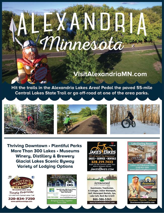
e xploreminnesota .c om B-3
exploreminnesota.com

                               2019-20 BIKING GUIDE
                                                      A special supplement produced by Minnesota Monthly
CONTENTS                                              in partnership with the State of Minnesota
B - 8 TWIN CITIES BIKING VACATION
View iconic landmarks while riding local trails
around the Twin Cities                                RESOURCES
                                                      EXPLORE MINNESOTA
B - 1 0 BIKE -FRIENDLY LODGING                        exploreminnesota.com • 888-VISITMN
Minnesota lodging facilities that embrace their       Travel information: where to stay (hotels, resorts, B&Bs, campgrounds)
pedaling patrons                                      and other fun things to do on your trip, including information on local
                                                      attractions, festivals, trail reports and more
B - 1 2 WINTER BIKING
Fat biking and winter road biking keep cyclists on    MINNESOTA DEPARTMENT OF NATURAL RESOURCES
two wheels during the winter                          mndnr.gov • 651-296-6157 • 888-646-6367
                                                      Information on biking state trails, state parks and state forests
B - 1 4 PAVED TRAILS
Plan your ride on more than 30 trails statewide       MINNESOTA DEPARTMENT OF TRANSPORTATION
                                                      mndot.gov • 651-296-3000 • 800-657-3774 (from MN)
B - 2 4 MOUNTAIN BIKING                               Information on statewide planning, open houses, workshops, conferences,
Everything from rolling gravel roads to               and links to many bicycle maps and other resources
lung-busting ski hills

B - 3 0 BIKING LISTING S
Where to shop, where to play, where to rest your
head at the end of the day
                                                                                                                                MESABI TRAIL JILLIAN DECHAINE PHOTOGRAPHY

B - 3 2 BIKING EVENTS
A small sampling of not-to-miss races and biking                                                    ON THE COVER
                                                                                                    Two mountain bikers
events throughout the state                                                                       ride around a bend on
                                                                                                the Duluth Traverse trail

                                                                                                          PHOTO BY
                                                                                                         Hansi Johnson

B-4   Biking Guide 2019 -20
Visit the Gateway to
              Twin Cities Biking
                                                                      • Mississippi River Trail /
                                                                        U.S. Bike Route
                                                                      • Hundreds of miles of
                                                                        interconnected routes
                                                                      • Check out our Blog
                                                                        for unique biking
                                                                        opportunities
                                                                      • 21 lodging properties

                                                                      tcgateway.com/biking
   Anoka • Blaine • Coon Rapids • Fridley • Ham Lake • Lino Lakes • Mounds View • New Brighton • Shoreview

CYCLE AROUND BLOOMINGTON
                                                                                   FIND THE PERFECT
                                                                                  SCENIC ADVENTURE
                                                                                 Cyclists of all skill levels can find
                                                                              enjoyment on many of our picturesque
                                                                               trails. And when you’re done cycling,
                                                                              pedal your way to Mall of America® for
                                                                             indoor entertainment, tax-free shopping,
                                                                              dining and attractions for all ages. Then
                                                                              when it’s time to call it a day, kick back
                                                                              and relax at your choice of 40+ hotels.
                                                                                   • Minnesota Valley National
                                                                                     Wildlife Refuge
                                                                                   • Bass Pond Loop
                                                                                   • Bloomington Bluff Trails
                                                                                   • Hyland Lake Park Reserve
                                                                                   • Long Meadow Lake Trail
                                                                                   • Normandale Lake Park

                                                                             Visit BloomingtonMN.org/biking

                                                                                                e xploreminnesota .c om    B-5
Ready, Set, Ride
           picture this: the landscape rolling out                            mountain bike in the middle of winter. We have chari-
           in front of you. Sunlight peeking through the trees.               table bike races, professional bike races and races just
           The wind rushing past as you pedal along Minne-                    for the fun of it. Our biking culture is enthusiastic and
           sota’s extensive network of paved and rugged routes.               welcoming, with friendly local bike shops and riding
           Whether you’re a leisurely cruiser, a clipped-in roadie            groups hosting events and spreading the joy of two-
           or somewhere in between, there’s no denying the rush               wheeled travel. Locals love making our state more
           of freedom that comes from the saddle of a bicycle.                accommodating for riders: There are over 23 towns
              Home to some of the best biking trails in the coun-             designated as “Bicycle Friendly Communities.”
           try, Minnesota is a cyclist’s paradise. Our 4,000-mile                Whether you’re completely new to cycling or a vet-
           network of paved trails includes scenic lake loops,                eran pedaler, consider this your go-to resource for all
           leisurely city rides, shaded routes through hardwood               things biking in the state. Now all you need to do is grab
           forests and vista-filled rambles along some of Minne-              your helmet, choose a trail and go!
           sota’s mightiest rivers. Think Minnesota is flat? Nope.               For maps, lists of biking events and clubs, safety
           Mountain bikers will find plenty of invigorating, white-           tips and trip ideas from local bike ambassadors, visit
           knuckle trails throughout the state, as well.                      exploreminnesota.com.
              We have bike-sharing programs in multiple cities,
           tune-up stations on many popular trails and places to

                                                 AS YOU READ THIS GUIDE,
                           PLEASE NOTE THAT CERTAIN TRAIL “EXTRAS” ARE HIGHLIGHTED WITH THESE ICONS:

                      TUNE-UP STATIONS                             WINTER FAT BIKING                  BICYCLE FRIENDLY COMMUNITIES
           Need to fix a flat tire or tighten a loose   Wide rims and huge wheels with gi-          These Minnesota communities saw the
           bolt on the trail? No problem. More than     ant treads can conquer almost any           value in becoming more bike-friendly
           40 permanent bicycle tune-up stations        terrain—even snow- and ice-covered          places to live and received national
           are situated along Minnesota state           Minnesota landscapes. Join the grow-        recognition from the League of Ameri-
           trails and in state parks. Each station      ing number of cyclists who love the         can Bicyclists as being Bicycle Friendly
           offers free tools and an air compres-        thrill of fat biking in winter, available   Communities. Trails with this icon
           sor tire pump for easy and convenient        in certain locations, designated with       connect to one or more of these com-
                                                                                                                                               G I T C H I - G A M I S TAT E T R A I L WA Q A R A H M A D

           maintenance. For a full list of locations,   these icons. (While groomed snowmo-         munities. For the most up-to-date list,
                   visit mndnr.gov/tuneup.              bile and ski trails may look appealing         visit bikeleague.org/community.
                                                        to those interested in fat biking, many
                                                        of these trails aren’t open to other
                                                        uses.) For up-to-date information on
                                                        where to ride fat bikes on state trails
                                                        and in state parks/recreation areas,
                                                                visit mndnr.gov/fatbike.

B-6   Biking Guide 2019 -20
VISITBRAINERD
    Choose Your Adventure.

                                                                                                                                  #LoveBrainerd
                                                                                                                                                      www.visitbrainerd.com

      / / / / / / Plan a Biking Trip to the Brainerd Lakes Area / / / / / /
                                    Enjoy all the area has to offer from centrally located Brainerd and Baxter.
                                         Maps, routes, lodging and visitor information available online.

            Paul Bunyan Trail • Gull Galivant Route • Cuyuna Lakes Trail • Cuyuna Lakes Mountain Bike Trails
                                           Pillsbury Forest Mountain Bike Trails

                                                                                                                                               Lum Park Campground
 218-822-5634           218-829-0391       218-822-1133         218-825-7234       218-828-2161        218-829-3080        218-824-3232          218-828-2320           218-828-0027         218-828-4288
6967 Lake Forest Road   7836 Fairview Rd   7208 Fairview Road    7376 Woida RD     15058 Dellwood Dr   14466 Dellwood Dr   15739 Audubon Way   1619 NE Washington St.    11617 Andrew St.    14341 Edgewood Dr
  Baxter, MN 56425      Baxter, MN 56425    Baxter, MN 56425    Baxter, MN 56425    Baxter, MN 56425    Baxter, MN 56425    Baxter, MN 56425     Brainerd, MN 56401     Brainerd, MN 56401    Baxter, MN 56425
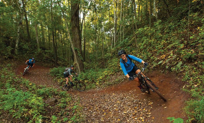
Two Wheels,
                                                         Twin Cities
                                                         biking in the twin cities is a bit like biting into a juicy lucy.
                                                         It seems relatively straightforward at first (“How is this different from a
                                                         cheeseburger?”), but there’s no denying the truth after your first ride. Like the
                                                         Juicy Lucy, biking in the Twin Cities is more than the sum of its parts—and it’s
                                                         better here than practically anywhere else in America. So, hop on your pedal-
                                                         powered chariot (or rent one from Wheel Fun Rentals, various bike shops, or
                                                         the Nice Ride or Lime bike-sharing services) and take in the sights, sounds and
                                                         scenic beauty on these popular paved and unpaved trails in Minneapolis-St. Paul.
                                                         CHAIN OF LAKES
                                                         A local favorite, especially in the summer months, is the 15-mile bike path circling
                                                         the interconnected Chain of Lakes in Minneapolis: Brownie Lake, Cedar Lake,
                                                         Lake of the Isles, Bde Maka Ska and Lake Harriet. Separate pedestrian and biking
                               NORTH LOOP, MINNEAPOLIS
                                                         trails create less congestion and more stress-free cycling. Rentals are available
                                                         at Lake Harriet and Maka Ska.
                                                         MIDTOWN GREENWAY
                                                         Stretching from the Chain of Lakes to the Mississippi River, the world-famous
                                                         Midtown Greenway is like a bike highway for south Minneapolis. The 5.5-mile
                                                         former railroad corridor is grade-separated from the street grid, providing barrier-
                                                         free and traffic-free bicycling. Find an abundance of local eateries and shops on
                                                         Lake Street, one block south of the Greenway, or connect to the Hiawatha Bike
                                                         Trail for direct access to U.S. Bank Stadium.
                                                         MISSISSIPPI RIVER TRAIL
                                                         Ride the Twin Cities’ portion of the Mississippi River Trail as it follows the mighty
                                                         river from north Minneapolis to downtown St. Paul and beyond. Make pit stops
                                                         for iconic Twin Cities landmarks along the way, such as the Stone Arch Bridge,
                                                         Minnehaha Falls and historic Fort Snelling.
                                                         SUMMIT AVENUE
                                                         Extending across St. Paul from the Mississippi River to downtown, Summit
                                                         Avenue’s 4.5 miles of tree-lined bicycle lanes offer visitors a time capsule of
                                                         Victorian-era opulence. Summit boasts the longest stretch of Victorian homes
                                                         in the entire country, some of which have housed famous residents including
                                                         Minnesota-born authors F. Scott Fitzgerald and Sinclair Lewis. Stop for tours of
                                                         the Governor’s Residence, the James. J. Hill House and the Cathedral of Saint Paul.
                                                         THEODORE WIRTH REGIONAL PARK
                                                         Minutes from downtown Minneapolis, a wooded oasis for off-road adventures
                       MIDTOWN GREENWAY, MINNEAPOLIS
                                                         awaits on Theodore Wirth’s 6 miles of intermediate mountain biking trails. The
                                                         new Trailhead center creates a hub for outdoor enthusiasts, complete with a bike
                                                         and ski rental shop, locker rooms, strength and conditioning room, and Cajun
                                                                                                                                                 A B O V E WA Q A R A H M A D B E L OW M E L A N I E G R AV E S

          1.5 MILLION BIKE RIDES ARE TAKEN               Twist restaurant.
          ON THE MIDTOWN GREENWAY IN
          MINNEAPOLIS EVERY YEAR.                        LEBANON HILLS REGIONAL PARK
                                                         The variety in both difficulty and scenery on Lebanon Hills’ 12 miles of singletrack
                                                         trails make it a top choice for Twin Cities mountain bikers. The suburban park,
                                                         located in Eagan adjacent to the Minnesota Zoo, invites riders of all skill levels
                                                         to experience routes that transform from rolling hills to wooded lakeside paths,
                                                         with new sights around each twist and turn. Give your bike a quick tune-up at
                                                         the park’s West Trailhead facility, which offers a bike repair station, air pump,
                                                         maps and more.
B-8   Biking Guide 2019 -20
Call
y for
Toda ies!
n c
Vaca
AWARD-WINNING WINE
BEER ON TAP
SPECTACULAR FOOD
UNFORGETTABLE EVENTS
CrowRiverWinery.com • 320-587-2922
507.467.2598
www.eagle-cliff.com
“A stunningly
beautiful campground
in the heart of bluff country.”
u 226 Sites (Tent, RV, Permanent)
u RV sites with Full Hookups
u Seasonal Sites with Full Hookups
u 5 unit hotel sleeps up to 22 guests
u Tube, Canoe and Kayak Outfitting
u Banquet Facility: seats 80 plus
u On the Root River with access to Bike Trail
35455 State Hwy 16 E, Lanesboro
e xploreminnesota .c om B-9Bike-Friendly Lodging
MINNESOTA HAS YOU (AND YOUR BIKE ) COVERED
W
hether you’re in the middle of a cross-
country bike tour or simply stretching your legs
after a long day of riding, one thing is certain:
Bike-centric vacations have distinct lodging needs.
Fortunately, these Minnesota lodging facilities embrace their
pedaling patrons by committing to bike-friendly policies and
perks that are sure to get any bike tourist pumped.
For the camping crowd, True North Basecamp provides
mountain bikers with the perfect blend of wilderness and
Wi-Fi. Built in the heart of Cuyuna Country State Recre-
ation Area, True North’s 23 campsites and six “north woods
industrial” cabins offer modern conveniences like heat and
air conditioning just feet away from Cuyuna’s world-famous
mountain bike trails.
State parks often make for an excellent bike camping expe-
rience, as well. Sakatah Lake State Park—bisected by the
CABIN AT TRUE NORTH BASECAMP
39-mile paved Sakatah Singing Hills Trail that runs between
Mankato and Faribault—keeps five campsites permanently on
reserve for visitors who bike into the park without motorized
vehicles. Mississippi River Trail cyclists will also find five
bike-specific campsites at Great River Bluffs State Park,
the southernmost state park on the trail’s Minnesota segment.
Or plan a trip to a bike-friendly resort like Giants Ridge in
Biwabik, where mountain bikers can shred more than 25 miles
of challenging singletrack trails on the resort’s steep, punchy
terrain. In the winter, the singletrack trails are even groomed
for fat biking. Trail cyclists staying at Giants Ridge can hop on
the 115-mile paved Mesabi Trail to pedal to the Iron Range’s
famous open-pit mines and friendly small towns. ST. PAUL
In real estate, and for bike tourists, location is everything.
That philosophy rings true at Embracing Pines Bed & Break-
fast, found on the Paul Bunyan State Trail just 7 miles outside The most notable bike-friendly hotel in Minneapolis, Le
downtown Walker. The trailside location and stunning, forest Méridien Chambers, is located in the heart of downtown’s
landscape make this B&B a popular spot for bikers. Embrac- famous theater district, but its complimentary “bicycle pro-
ing Pines also offers shuttle service for the Paul Bunyan and gramme” is no stage prop. Le Méridien keeps summer- and
A B O V E T R U E N O R T H B A S E C A M P B E L OW A N N A M I N
Heartland trails. winter-specific bikes, along with helmets and locks, on hand to
keep you pedaling all year-round. Thanks to the hotel’s central
location, the city’s dense network of bike lanes and paved trails
is at your doorstep. Within minutes of fastening your helmet,
BETWEEN 87-96 MILLION BICYCLE RIDES you can be snapping photos on the Stone Arch Bridge or explor-
ARE TAKEN EVERY YEAR IN MINNESOTA.
ing the Minneapolis Sculpture Garden. A few more minutes of
pedaling gets you to Uptown, the North Loop, Northeast, Loring
Park, Cedar Riverside and many other unique neighborhoods.
For private or group bike tours, contact Minneapolis By Bike.
B-10 Biking Guide 2019 -20AND
Relax, unwind, and bike
the trails of the Willmar Lakes Area.
Home to the Glacial Lakes
State Trail and a variety of
other scenic pathways.
Bike Maps
Available
Play STAY SHOP EAT
e xploreminnesota .c om B-11Minnesota
is a Fat
Biker’s
Paradise
F
at bikes are making their way
around Minnesota! But don’t take our
word for it: Outside Magazine recently
called the state “home to one of the most
robust fat biking scenes in the country.” If you
haven’t seen them yet, keep an eye out the next
time you’re near a Minnesota park, trail or bike MISSION CREEK TRAILS
shop. These incredible bikes with oversized tires
are giving a whole new meaning to the words
“winter biking,” especially in Minnesota. Instead
of riding on a layer of ice or slush on the side of
the road, take your cycling to the beautifully
snow-packed hills in the middle of a state park
or on a groomed trail.
These days, it’s hard to shake a stick without THE ABILITY TO
hitting a Minnesota fat biking trailhead. The Min- CHANGE TIRE
PRESSURE IN
nesota Department of Natural Resources operates DIFFERENT CONDITIONS IS
KEY TO FAT BIKING. RIDERS USE
six trail systems across the state that welcome PRESSURES IN THE 3-5 PSI RANGE
fat bikes, providing intrepid riders more than 60 PARK POINT
FOR SOFT CONDITIONS, 8-10 PSI
FOR TRAIL RIDING AND 12-15 PSI
miles of year-round fat tire fun. The trails vary in FOR ON-ROAD URBAN RIDING.
difficulty level, but all are groomed specifically for
the large, low-pressure tires that give the bikes
their name. In addition to the many opportunities for fat biking WINTER ROAD BIKING
at state parks and recreation areas, an increasing number of Min- No fat bike? No problem. For many riders in Minnesota, winter
nesota’s municipal park systems have also embraced fat bike trails. is still road bike season. Thanks to innovations in equipment and
Head to the Mountain Biking section on page 24 of this guide to clothing, it’s easier than ever to keep riding through the winter
find places to ride across the state. (studded tires, anyone?).
The best way to enjoy a long, snow-filled Minnesota winter Road biking through a Minnesota winter will challenge your
is not cooping yourself up indoors; it’s spending it outside. Fat mind and your body. Snow-covered expanses of tundra and strong
A B O V E H A N S I J O H N S O N B E L OW A LY S S A H E I
biking is a great way to get outdoors, stay active and embrace the headwinds are the norm, and road grime will try to devour your
weather all at once. Yes, it may be cold. And, yes, there will be drivetrain whole.
snow. But that just means there are unparalleled opportunities But for all its challenges, winter road biking in Minnesota is
for winter fun. The vast, white winter landscape stretches out in also strikingly beautiful. Many year-round road bikers agree that a
every direction. Your breath crystallizes in mid-air, hanging in sunny, 20-degree day in January is just about the perfect day for a
front of your face like a mask. The world is a blank canvas, and ride. That may sound like an exaggeration, but it’s the truth: Winter
a fat bike is your paintbrush. There’s simply nothing else like it. road biking in Minnesota is absolutely spectacular.
LEARN MORE ABOUT WINTER BIKING, INCLUDING PLACES TO RIDE, FAT BIKE EVENTS, GEAR TIPS AND MORE, AT exploreminnesota.com.
B-12 Biking Guide 2019 -20Call For Free Trail Map
800.952.4282
www.hinckleymn.com
THE SOURCE OF Discovery
Pedal at your own pace Explore Itasca Park on two wheels Cruise the Heartland Trail
bikes that give baCk.
• bikes
• CoMponents
• aCCessories
• repairs
3
• speCial orders
| 800-247-0054 | www.parkrapids.com 3515 ChiCago ave, Minneapolis
(612) 824 - 7581 | fullCyClebikeshop.org
BEST
BIKING
DESTINATIONS
IN MINNESOTA
COVE POINT LODGE CHASE ON THE LAKE PIER B RESORT
NORTH SHORE, MN WALKER, MN DULUTH, MN
GITCHI-GAMI TRAIL HEARTLAND & PAUL BUNYAN TRAIL WILLARD MUNGER STATE TRAIL
CovePointLodge.com ChaseOnTheLake.com PierBResort.com
e xploreminnesota .c om B-13Paved
BIKE TRAILS
PHOTO ANNA MIN
BRUCE VENTO TRAIL, ST. PAUL
B-14 Biking Guide 2019 -20Baudette TUNE-UP STATIONS
WINTER FAT BIKING
Thief River Falls
F BICYCLE FRIENDLY COMMUNITIES
East Grand Forks Mesabi
Ely
The Greenway
i CASEY JONES STATE TRAIL
am
Bemidji hi-G Location: Currie and Pipestone
Migizi itc
Paul Bunyan G
Distance: Three main unconnected sections: 13 miles between
Heartland Grand
Rapids Pipestone and Woodstock (5 paved miles); a 1.5-mile naturally
Park Rapids
Moorhead
Duluth surfaced segment into the city of Lake Wilson; and a 6-mile paved
Paul
Bunyan
loop between Lake Shetek State Park and the city of Currie
Cuyuna
Lakes
Braine
erd
Paved Trails
Named after a famed railroad engineer, the Casey Jones State
Willard
Trail goes past the countryside as it links Lake Shetek State Park
Ce
Munger
nt
La e
Lin
ra
ke Soo
l
s
Mil
le L
acs
with Currie, home to the End-O-Line Railroad Park and Museum.
Alexandria
Finish your ride at the nearby Pipestone National Monument, a
Lake
Wobegon
St. Cloud sacred American Indian quarry.
ay
Sunrise Prairie/ Grand Mississippi
For more info: 507-831-2900; mndnr.gov/trails. Map online.
Hardwood Creek
ew
Rounds River Trail
Gat
Elm Creek Park/ Minneapolis
nn
Glacial Rush Creek ga
n
Willmar
Lakes or
M
l H. St. Paul
Luce Line ue
Brown’s Sa
m DOUGLAS STATE TRAIL
Creek
Location: Between Rochester and Pine Island
Dakota Rail Midtown
Cedar Lake/ Cedar Lake Greenway
Minnesota River Bluffs
Cannon Distance: 13 paved miles
SakataHhills
Valley Goodhue
Mankato
Singing Faribault Pioneer Shaded by a canopy of trees, this trail travels past rolling
Do
Great
Casey Jones River farmland and rural scenery. Several bridges cross the Zumbro
ug
Red Jacket
Ridge
las
River, the northernmost crossing providing entry into Pine
Roc
o hester
River
Blazing Root
Star
Island Park (complete with a playground and picnic shelter) and
Harmony-
W rthington
Wo Star Preston Valley
connecting to historic Main Street. The southern end of the trail
links to the extensive bikeways system in Rochester, home of the
world-renowned Mayo Clinic.
For more info: 507-206-2847; mndnr.gov/trails. Map online.
Southern Minnesota
GOODHUE PIONEER STATE TRAIL
BLAZING STAR STATE TRAIL Location: Between Red Wing and Zumbrota
Location: Albert Lea Distance: 4 paved miles from Red Wing to Hay Creek (connects
Distance: 6 miles to Cannon Valley Trail); 4.5 paved miles in Zumbrota (connects
Start your journey at Frank Hall Park, then enjoy views of rural to city trail system)
landscapes along the Blazing Star State Trail, linking Albert Lea It’s not unusual to see wild turkeys, partridges, foxes and pheas-
to Myre-Big Island State Park. Pass Albert Lea Lake and scenery ants as you pass through a scenic mix of tallgrass prairies, maple
including oak savanna, several wetlands, old-growth hardwood and basswood forests, and oak savanna. When complete, the trail
forest and a prairie landscape. The trail is a work in progress. will span 47 miles and connect Red Wing, Goodhue, Zumbrota,
When completed, it will be 20 miles long and connect Albert Lea Mazeppa, Bellechester and Pine Island.
and Austin via Big Island State Park and Hayward. For more info: 507-206-2847; mndnr.gov/trails. Map online.
For more info: 507-414-6193; mndnr.gov/trails. Map online.
GREAT RIVER RIDGE STATE TRAIL
CANNON VALLEY TRAIL Location: Between Plainview and near Eyota, northeast of
Location: Between Cannon Falls and Red Wing Rochester
Distance: 19.7 paved miles Distance: 13 paved miles
Paralleling the Cannon River, the Cannon Valley Trail offers Built on a former railroad grade, the Great River Ridge State
glimpses of the winding river as it passes by wooded hillsides, Trail is a fairly easy ride (even recommended for kids), becoming
cliffs, farm fields and rolling pastures. Built on a former railroad gradually hilly at Elgin. See prairie flowers and cross a 100-year-old
line, the mostly flat trail features rest stops to appreciate scenic trestle. Two additional miles into Eyota are in the works.
views. (The grade is never very steep, the trail is mostly shaded, For more info: 507-206-2847; mndnr.gov/trails. Map online.
and there are very few crossings.) Start your ride in Cannon
Falls, Red Wing or Welch and experience Minnesota small-town HARMONY-PRESTON VALLEY STATE TRAIL
hospitality at its best. Location: Between Harmony and Preston, southeast of
Trail fee: $5 daily wheel pass for 18 and over; $25 for a season. Rochester
For more info: 507-263-0508; cannonvalleytrail.com. Distance: 18 paved miles (connects to Root River State Trail)
Map online. This area lives up to its Bluff Country nickname with wooded,
e xploreminnesota .c om B-15CUYUNA LAKES STATE TRAIL
rolling countryside, winding rivers and charming towns. Unlike attractions. It doesn’t follow an old railroad track and it’s not flat,
trail sections that follow old railroad routes, the path between only adding to the adventure. Lanesboro attracts thousands of
Harmony and Preston zips up and down steep hills. There’s a mix bikers every year.
of woods, fields and attractions—like a toy museum, goat farm and For more info: 507-206-2847; mndnr.gov/trails. Map online.
shops carrying Amish handcrafts—along the way.
For more info: 507-206-2847; mndnr.gov/trails. Map online. SAKATAH SINGING HILLS STATE TRAIL
Location: Between Faribault and Mankato
RED JACKET TRAIL Distance: 39 paved miles
Location: Between Mankato and Rapidan The big woods meet the prairie along the mostly straight,
Distance: 6 miles of paved trails (connects to other trails) mostly flat Sakatah (pronounced Sah-KAH-tah) Singing Hills
Two small parks lie along the short, scenic Red Jacket Trail: State Trail. The trail runs through a landscape of farmland, river
Weagel Park, 1 mile south of Mankato, and Red Jacket Trail Park crossings, lakes, wetlands and woods, with trees shading most of
on the Le Sueur River, with parking at both locations. The trail the corridor. One of the trail’s anchor towns, Faribault, consists
itself passes Mount Kato, a ski area and mountain bike park, of beautiful old storefronts, antique shops and restaurants.
before traveling along a wooded, secluded hillside over railroad For more info: 507-698-7852; mndnr.gov/trails. Map online.
trestles, past rural scenery and into the village of Rapidan, where
you can bike to the Dam Store for a slice of pie. SHOOTING STAR STATE TRAIL
For more info: 507-304-4025; blueearthcountymn.gov. Map online. Location: Between LeRoy and Rose Creek
Distance: 20 paved miles
ROOT RIVER STATE TRAIL This trail, named for a prairie flower, lives up to its name with
Location: From Fountain through Lanesboro, Whalan, Peterson, colorful prairie flowers in full bloom in late summer and early
Rushford and Houston fall. Experience rural Minnesota in tiny Taopi (fewer than 100
Distance: 42 paved miles (connects to Harmony-Preston Valley residents) and LeRoy (less than 1,000). The trail passes through
PHOTO CUYUNA.COM
State Trail) quiet Lake Louise State Park, with a picnic area and swimming
The Root River State Trail has a reputation as the “Cadillac of beach on the old millpond. When completed, the trail will also
Trails,” with beautiful scenery (limestone cliffs, pastures, fields connect to Austin and Lyle.
of wildflowers, wooden bridges, a river) and plenty of small-town For more info: 507-414-6193; mndnr.gov/trails. Map online.
B-16 Biking Guide 2019 -20Central Minnesota
tower overlooking Mille Lacs Lake (the state’s second-largest
CENTRAL LAKES STATE TRAIL inland lake). The trail connects with the Soo Line bridge over
Location: Between Fergus Falls and Osakis Highway 169.
Distance: 55 paved miles (connects to Lake Wobegon Trail) For more info: 888-350-2692; millelacs.com.
Wildflowers, prairie grasses, open fields, rolling hills, wetland
ponds and wildlife add to the scenery on the fairly secluded
Central Lakes State Trail. Lakes, barns and pastures are also part Northwest Minnesota
of the landscape.
For more info: 218-739-7576; mndnr.gov/trails. Map online. GREATER GRAND FORKS GREENWAY
Location: East Grand Forks
CUYUNA LAKES STATE TRAIL Distance: 10 paved miles (in Minnesota)
Location: Between Crosby and Riverton Winding along the Red River and Red Lake River, the Greater
Distance: 8 paved miles within Cuyuna Country State Recre- Grand Forks Greenway provides 2,200 acres of natural space
ation Area; 1 mile passes through Aitkin along Highway 169 along the border of North Dakota and Minnesota. There are
This is an exceptionally scenic route through Cuyuna Coun- approximately 10 miles of paved trails on each side of the state
try State Recreation Area, offering views of crystal clear lakes line, creating 20 total miles of multi-use paths to enjoy. The
(former mining pits), streams, woods and relics of the area’s trails pass by parks, two golf courses, campgrounds and sites for
mining past. year-round recreation. The Greenway connects to the greater
For more info: 218-203-4442; mndnr.gov/trails. Map online. Grand Forks trail system.
For more info: 701-746-2750; greenwayggf.com. Map online.
GLACIAL LAKES STATE TRAIL
Location: Between Willmar and Paynesville, and Roscoe and HEARTLAND STATE TRAIL
Cold Spring Location: Between Park Rapids and Cass Lake
Distance: 22 miles between Willmar and the Kandiyohi/Sterns Distance: 49 paved miles
County line; 5 miles from Richmond to Roscoe The original stretch of the Heartland State Trail between Park
From Willmar to Spicer, this trail goes by pastures, fields of Rapids and Walker passes through farmland and wooded areas,
corn and soybeans, ponds and wetlands. About midway, at Spicer, near marshes and lakes. You can cool off at the beach, pose for a
cool off in Green Lake. North of here, the trail crosses a bridge selfie with Paul Bunyan in Akeley or visit charming restaurants
over Nest Lake and skirts to the east of New London. and shops. The trail connects with the expansive Paul Bunyan
For more info: 320-796-2161; mndnr.gov/trails. Map online. State Trail near Walker.
For more info: 218-308-2372; mndnr.gov/trails. Map online.
LAKE WOBEGON TRAIL
Location: Between St. Joseph and Osakis, with a spur north from MIGIZI TRAIL
Albany to Holdingford Location: Cass Lake
Distance: 63 paved miles Distance: 19 paved miles (connects to Heartland State Trail)
This trail, inspired by the fictional Minnesota town where Watch for soaring eagles as you ride among the big pines on the
all the children are above average, leads riders past farmland, Migizi Trail (Migizi is the Ojibwe word for “eagle”), a Chippewa
lakes, and near two college campuses, two monasteries and the National Forest trail forming a wide horseshoe around three
childhood home of Nobel Prize-winning author Sinclair Lewis. sides of Pike Bay. The trail travels through conifer and northern
Experience peaceful stretches of farm country, lakes and wet- hardwoods, across wetlands and along the Pike Bay lakeshore.
lands. The Lake Wobegon Trail connects to the Central Lakes After crossing Highway 2, a mile and a half of the trail juts out
and Soo Line trails, providing more than 125 continuous miles to Norway Beach Recreation Area, a popular campground in
of paved biking trails. the summer.
For more info: 800-264-2940; lakewobegontrail.com. For more info: 218-335-8600; fs.usda.gov/chippewa.
Map online.
PAUL BUNYAN STATE TRAIL
MILLE LACS SOO LINE TRAIL Location: From Crow Wing State Park in the Brainerd Lakes to
Location: Between Onamia and Isle, south of Mille Lacs Lake Lake Bemidji State Park
Distance: 11 paved miles Distance: 115 paved miles (not including short on-road connec-
Travel from Father Hennepin State Park in Isle to Kathio State tions through Baxter and Bemidji)
Park in Onamia for a remote ride along a paved trail with some The Paul Bunyan State Trail is the longest continuously paved
low-volume highway travel. Ride to the 100-foot observation Minnesota bike trail, connecting to the Heartland State Trail, the
e xploreminnesota .c om B-17ON-ROAD
Touring
Grand Portage
Grand Marais
Silver Bay
GITCHI-GAMI STATE TRAIL Two Harbors
Duluth
Hinkley
Blue Ox Trail and the Cuyuna State Trail. The final paved portion of the trail was finished
in 2014, connecting Guthrie south through Laporte toward Walker and Brainerd/Baxter White Bear Lake
Minneapolis - St. Paul
south to Crow Wing State Park. With the paving of these segments, the Paul Bunyan
State Trail, ranging from flat and open to hilly and scenic, offers 115 miles of paved trail
for all levels of riders.
For more info: 218-308-2372; mndnr.gov/trails. Map online.
USBR 41:
North Star Route (NSR)
Northeast Minnesota It takes less than three hours
GITCHI-GAMI STATE TRAIL
to drive from St. Paul to Duluth
Location: Along the North Shore of Lake Superior on the highway. That same
Distance: 30 paved miles in five segments; the longest section is 17 miles from Goose- trip could take anywhere from
berry Falls State Park to Silver Bay two to four days by bike—and
Biking this trail is an excellent way to take in the beauty of the North Shore, with that’s not a downside, it’s a plus.
dramatic views of Lake Superior. When completed, the trail will be 89 paved miles con-
Traveling by bike is all about
necting Two Harbors to Grand Marais. Some of the trail runs parallel to Highway 61, and
other parts travel through state parks on hilly terrain. One spur leads to the photo-worthy
slowing down to explore the
Split Rock Lighthouse. The 3-mile stretch from Schroeder to Tofte passes through the spaces between: The towns
scenic Temperance River State Park, offering views of Carlton Peak. between highway ramps, the
For more info: 218-834-1430; mndnr.gov/trails. Map online. roadside attractions between
towns. So slow down a bit
MESABI TRAIL
and explore the North Star
Location: Between Grand Rapids and Ely
Distance: More than 135 miles of paved trails. The longest section connects Grand
Route, Minnesota’s newest
Rapids to Highway 135 just beyond Giants Ridge in Biwabik—about 95 miles. Other pieces on-road designated bike route.
include spurs around Grand Rapids, Chisholm, Eveleth and Aurora; with additional trail Beginning at the State Capitol
around Tower and Ely. in St. Paul, you’ll head north
Built partially on old railroad beds, logging and mining roads, the Mesabi Trail takes for 315 miles until reaching
riders through northeast Minnesota and the Iron Range, into woods, near creeks and
the Minnesota/Canada border
ponds, and by several old mining pits filled with emerald green water. When completed,
the Mesabi Trail will traverse 155 miles and connect to 28 communities.
at Grand Portage State Park.
Trail fee: A wheel pass is required for those 18 and over using a wheeled device; $5 In the space between those
for a three-day pass or $15 for a season pass. These passes are available online or from two far-flung destinations,
vendors along the trail. the North Star Route passes
For more info: 877-637-2241; mesabitrail.com. through nine state parks
and two national parks, and
WILLARD MUNGER STATE TRAIL
Location: Between Hinckley and Duluth
connects the Mississippi River,
Distance: 70 paved miles (connects to 6-mile Alex Laveau Memorial Trail) the world’s fourth-longest,
For panoramic views of the St. Louis River, hit the northeast part of this trail, running to Lake Superior, the world’s
P H O T O WA Q A R A H M A D
past rugged rock-cuts and rock outcrops. The southern part of the trail meanders through largest freshwater lake.
shaded rural countryside with picturesque small towns along the route. Points of interest mndot.gov/bike/usbr41
include the Hinckley Fire Museum and Jay Cooke State Park.
For more info: 218-460-7021; mndnr.gov/trails. Map online.
B-18 Biking Guide 2019 -20BIKE WADENA!
YEAR ROUND BIKING FOR ALL AGES
Photo by Ben Olson/Blacks Grove River Crossing Race
Photo by Jason Groth/Wadena Pioneer Journal
Family-Friendly Challenging Mountain Variety of Skill
Paved Paths Bike Trails Levels Welcome
And When You’re Finished Biking: Enjoy Shopping, Restaurants,
Lodging and the Maslowski Wellness Center with Pool and Hot Tub
JOIN US FOR BLACK’S GROVE MOUNTAIN BIKE & TRAIL RACE
urnal
SATURDAY,
ena Pioneer Jo
OCTOBER 19, 2019
BLACKSGROVE.COM
n Groth/Wad
Photo by Jaso
oth/Wadena Pio
neer Journal @BlackGroveRCR
Photo by Jason Gr
Wadena Area Convention
& Visitors Bureau
1-877-631-7704
Wadena.org /WadenaMinnesotaMinneapolis-St. Paul Area
GATEWAY STATE TRAIL
BROWN’S CREEK STATE TRAIL Location: Between St. Paul and Pine Point Park, north of
Location: Grant to Stillwater Stillwater
Distance: Nearly 6 paved miles Distance: 18 paved miles
Following a portion of the former Minnesota Zephyr railroad This trail runs from downtown St. Paul to the countryside of
route, this generally level trail follows Brown’s Creek (a desig- Stillwater, a pretty, safe, mostly shaded route. Although the trail
nated trout stream with a nicely shaded canopy), navigates golf is relatively flat—with an excellent mix of parks, lakes, wetlands
courses and crosses over Manning Avenue on a pedestrian bridge. and prairies along the way—there are some challenging hills in
It connects with the Gateway State Trail in the city of Grant, the Stillwater area. It connects to Brown’s Creek State Trail in
enabling trail users to go from the St. Croix River in downtown Grant. In addition to biking, the Gateway State Trail is popular
Stillwater to the mighty Mississippi in downtown St. Paul. Stop for in-line skating, walking and jogging, so if you prefer a quiet
at the audio listening station to hear bird songs, frog calls and ride, go midweek.
learn about nature found along the trail. For more info: 651-259-5841; mndnr.gov/trails. Map online.
For more info: 651-259-5841; mndnr.gov/trails. Map online.
GRAND ROUNDS BIKE TRAILS
CEDAR LAKE LRT REGIONAL TRAIL + Location: Minneapolis
MINNESOTA RIVER BLUFFS LRT REGIONAL TRAIL Distance: Over 51 miles
Location: Between Hopkins and Minneapolis Get to know Minneapolis on a tour of the Grand Rounds, a
Distance: 16.75 miles (paved east of Hopkins; aggregate west national scenic byway featuring bike trails mostly separated
of Hopkins) from pedestrian trails and roadways. Cycle past historic homes,
Enjoy the best of both worlds—urban skylines and suburban Nicollet Island, St. Anthony Falls, the Stone Arch Bridge, Minne-
tranquility—on this popular trail linking the western suburbs haha Creek, Minnehaha Falls, the Weisman Art Museum, Chain
to downtown Minneapolis and passing by Target Field (report- of Lakes, Theodore Wirth Park (stop at the wildflower garden
edly the most “biked-to” ballpark in the country). A downtown and bird sanctuary) and Victory Memorial Drive, honoring the
segment connects to the Mississippi River Trail’s portion of the soldiers of World War I. For a longer ride, the southern loop along
Grand Rounds bikeway. In Hopkins, the Cedar Lake LRT Regional the scenic (and often shaded) Mississippi River is the way to go.
Trail connects to the limestone-surfaced Minnesota River Bluffs For more info: 612-230-6400; minneapolisparks.org. Map
LRT Regional Trail. available at park buildings, including the Longfellow House in
For more info: threeriversparks.org Minnehaha Park.
DAKOTA RAIL REGIONAL TRAIL DAKOTA RAIL REGIONAL TRAIL
Location: Between Wayzata and New Germany
Distance: 26 paved miles
This trail meanders through beautiful suburban and rural
areas on the west side of the Twin Cities, offering both town
and country views. It passes the two largest lakes in the metro,
Minnetonka and Waconia, as well as Gale Woods Farm.
For more info: co.carver.mn.us/parks (western portion);
threeriversparks.org (eastern portion).
ELM CREEK PARK RESERVE/RUSH CREEK REGIONAL TRAIL
Location: Brooklyn Park, Corcoran, Dayton, Maple Grove
Distance: 29 miles
P H O T O C O U R T E S Y T H R E E R I V E R S PA R K D I S T R I C T
There are 20 miles of paved biking/walking trails through
the hilly terrain of Elm Creek Park Reserve. This trail network
connects with the Rush Creek Regional Trail, a 9.6-mile trail
that links Elm Creek to Coon Rapids Dam Regional Park on the
Mississippi River.
For more info: 763-694-7894; threeriversparks.org.
B-20 Biking Guide 2019 -20ON-ROAD
Touring FRIENDLY, KNOWLEDGEABLE & HELPFUL
FULL-SERVICE BIKE REPAIR SHOP
Trek Cannondale New & Used Bikes
Bemidji
Grand Rapids 507.786-9191 DOWNTOWNBICYCLESLLC.COM
Brainerd
St. Cloud
Minneapolis - St. Paul
Red Wing
Winona
La Crescent
HALF THE WHEELS,
USBR 45:
TWICE THE FUN!
Mississippi River Trail (MRT)
Like all great journeys,
cycling the Mississippi River
Trail begins quite humbly:
At a shallow stream in Itasca
State Park, the headwaters,
barely moving at all. But as
you cycle downriver along the
Mississippi, the small river
gradually becomes larger,
picks up speed and grows into
its awe-inspiring reputation.
Along its winding path to the
state’s southern border, the
MRT contains more than 700
miles of roads and paved trails
and passes through dozens of
welcoming cities and towns.
You’ll ride among Minnesota’s
ancient pine woods, conquer
soaring river bluffs, and find
an abundance of natural
and cultural highlights. But
before all that, your epic MRT
Paved Trails. Off-Road Cycling Trail.
adventure will start humbly:
Grand Rounds Scenic Byway Trail.
One pedal stroke at a time. Cedar Lake Trail. Luce Line Trail.
mndot.gov/bike/mrt Breweries. Distillery. Winery.
100+ Restaurants. 9 Hotels.
One Sweet Vacation.
www.DiscoverStLouisPark.com | 952.426.4047
e xploreminnesota .c om B-21LUCE LINE STATE TRAIL
Location: Plymouth though Watertown, Winsted, and Silver Lake to Hutchinson
Distance: 63 miles—limestone from Plymouth to Winsted, paved from Winsted to
Hutchinson, crushed granite from Hutchinson to Cedar Mills and natural (mowed grass)
from Cedar Mills to Cosmos.
In the east, pass the Wood-Rill Scientific and Natural Area (approximately 99.9 percent
of Minnesota’s “Big Woods” have been cut down, but in this area, 200-year-old trees tower
over the scenic site). From Hutchinson westward, the scenery shifts to tallgrass prairie.
Sections of this trail feel like riding down a quiet country road.
For more info: 651-259-5841; mndnr.gov/trails and threeriversparks.org. Map online.
MIDTOWN GREENWAY
Location: Minneapolis
Distance: 5.5 miles
The Midtown Greenway, sometimes referred to as a “freeway for bikes,” is the perfect
year-round urban bike experience, with the wide, smooth, mostly flat trail giving riders
a taste of Minneapolis from the Mississippi River to Uptown and the Chain of Lakes
area—without having to worry about busy vehicle traffic. On the western end of the trail,
the Greenway connects with the Cedar Lake LRT Regional Trail, linking Minneapolis
to St. Louis Park, Hopkins and beyond. The eastern end connects to the West River
Parkway along the Mississippi River. There’s a bike shop in the middle section and
Midtown Global Market nearby. The Greenway also connects to the Hiawatha LRT Trail,
providing access to the West Bank and University of Minnesota and over the freeway
into downtown Minneapolis.
For more info: 612-879-0105; midtowngreenway.org
SAMUEL H. MORGAN REGIONAL TRAIL
Location: St. Paul
Distance: 10 paved miles
Follow the Mississippi River between Crosby Farm Regional Park and Indian Mounds
Regional Park, take in views of the downtown St. Paul skyline, Cathedral and High Bridge,
and travel along trail connections to beautiful Indian Mounds Park, the Bruce Vento
Regional Trail and near the Bruce Vento Nature Sanctuary. The Highway 5 and I-35E
bridges each have a bike/pedestrian trail, providing a link to Dakota County’s 4-mile
Big Rivers Trail.
For more info: stpaul.gov/parks.
SUNRISE PRAIRIE TRAIL/HARDWOOD CREEK TRAIL
Location: Between North Branch and Hugo
Distance: 26 paved miles
Between North Branch and Forest Lake, the Sunrise Prairie Trail passes alongside
residential areas, farmlands, hardwood forests and wetlands, and bridges the Sunrise
River at two sites. Stop and rest at Stacy Lions Park, where there are picnic tables, a
shelter, drinking fountain and restrooms. In Washington County near Forest Lake, the
trail becomes the Hardwood Creek Trail; this section parallels Highway 61 south to
Hugo. Parking areas are available in each of the cities along the trail: North Branch, Stacy,
P H O T O M E L A N I E G R AV E S
Wyoming and at the Forest Lake Transit Center.
For more info: Chisago County: 651-674-2345; co.chisago.mn.us/recreation or Wash-
ington County: 651-430-8370; co.washington.mn.us
LAKE HARRIET, MINNEAPOLIS
B-22 Biking Guide 2019 -20GEAR UP
FOR FUN!
OWNER OPERATED
Come to Nokomis Cycle
Find yourself – maps online for knowledgable,
professional service
Over 280 miles of trails in the Twin Cities. backed by 20 years of
experience
763.559.9000 • ThreeRiversParks.org
Brands You Love
Custom Bikes
Accessories
Repairs & Service
Electric Bikes
EST.
1994
2019 MINNEAPOLIS BIKE TOUR
SUNDAY, SEPTEMBER 15, 2019 Your Neighborhood Bike Store
Take a tour of Minneapolis at your own pace, with no motorized traffic! 46th & Bloomington
All ages and abilities are welcome. Enjoy rest stops with great snacks Minneapolis, MN
and live music at the finish line.
612-721-2959
REGISTER AT MINNEAPOLISBIKETOUR.COM www.nokomiscycle.com
Use coupon code mnmo19 by May 31 for $5 off!
e xploreminnesota .c om B-23Mountain
BIKE TRAILS
P H O T O A A R O N W H AU TA L A
CUYUNA COUNTRY STATE RECREATION AREATUNE-UP STATIONS
WINTER FAT BIKING
BICYCLE FRIENDLY COMMUNITIES
Superior National Forest
CUYUNA COUNTRY STATE RECREATION AREA
Giants Ridge
Chippewa National Forest Location: Crosby-Ironton area
Distance: 30 miles of singletrack trails
Moorhead
Designated as a silver-level Ride Center by the Inter-
Detroit Lakes Duluth
national Mountain Bicycling Association, Cuyuna is
Detroit Mountain Duluth Trails
recognized as one of the top trail systems in the world.
Cuyuna Mountain Bike Trails This purpose-built trail system winds through a landscape
Milaca Trails
created by 70 years of iron ore mining, where water-filled
mining pits are now deep, crystal clear lakes. The varying
St. Cloud terrain makes for great mountain biking territory. The sin-
Elm Creek gletrack trails are carved into the rocky landscape, circling
Theodore Wirth St.
Paul lakes and winding over hills, through the woods, and across
Lebanon Hills Minneapolis bridges over little ravines. Elevated areas offer outstanding
Minnesota Valley
Murphy-Hanrehan views of the landscape’s many natural and mine lakes. The
Battle Creek Afton Alps
trails range from easy to extremely difficult. The Miner’s
Mount Kato
Mankato
Rochester
Mountain Rally Center welcomes visitors and provides a
Winona Trails
place for picnics and views of the Huntington Mine Lake.
New in 2019, the Miner’s Mountain bike skills area
features jump lines and technical skill areas for mountain
biking. An overnight yurt campground, managed by the
Minnesota DNR, is also available to cycling enthusiasts.
For more info: 218-546-5926; cuyuna.com
Northern and Central Minnesota
DETROIT MOUNTAIN RECREATION AREA
CHIPPEWA NATIONAL FOREST Location: Detroit Lakes
Location: Around Deer River, Grand Rapids, Walker and Distance: 11 miles + more in progress
Cass Lake The professionally designed mountain biking area—
Distance: Varies engineered to host all levels of mountain bike enthusi-
A favorite with mountain bikers is the Suomi Hills Trail asts—features gravity-fed trails, a skills park, and tight
System with slightly challenging topography. Drive the and twisty singletrack, contour and downhill flow trails.
Edge of the Wilderness Scenic Byway to reach this 19-mile Trails are open from sun up to sun down, with an honor
loop system, located north of Grand Rapids, where the pay system. Bikes are available for rent at the on-site
grass and dirt singletrack rolls between lakes and through shop. There’s even a Strider Adventure Zone just for kids
the birch trees. 18 months to 5 years, encouraging them to have fun while
The Cut Foot Sioux area is another popular, moderate- developing balance, motor skills and confidence.
level mountain biking site. Park at the Cut Foot Sioux For more info: 218-844-7669; detroitmountain.com
Visitor Center and hit the 13-mile Simpson Creek Trail.
The Visitor Center is 17 miles north of Deer River off DULUTH TRAILS
Highway 46. Simpson Creek connects with the 22-mile Location: Around Duluth
Cut Foot Sioux loop. This is a mix of narrow dirt trail, old Distance: Varies
gravel road and sand tote road. Mountain bike near the scenic shore of Lake Superior,
A short 3-mile trail in the Marcell area (north of Grand through wooded hillsides and over hilly terrain—ranging
Rapids) leads mountain bikers to the historic Joyce Estate from beginner-friendly flow trails to advanced/expert trails
on Trout Lake. Bring a picnic lunch and enjoy a stroll at the that take advantage of the city’s rocky landscape. Mission
lumber baron’s Adirondack-style estate. This is a narrow Creek Trails have 25 miles of beginner-intermediate level
tote road dirt trail—watch for hikers as you bike through trail overlooking the St. Louis River and Mission Creek val-
this scenic area. Parking areas are located on the north leys. (The trailhead is located in Chambers Grove Park on
and south end of the lake. Duluth’s far western edge.) At Spirit Mountain, you’ll find
For more info: 218-335-8600; fs.usda.gov/chippewa. lift-served downhill trails ranging from beginner to expert.
Maps online. Brewer Park features 5 miles, from beginner to advanced,
e xploreminnesota .c om B-25SPECIAL ADVERTISING SECTION
CUYUNA COUNTRY STATE RECREATION AREA
with the trailhead located on Haines Road; Piedmont, perched MILACA MOUNTAIN BIKE TRAIL
high atop Duluth’s hillside (taking advantage of the abundant Location: Milaca
bedrock features) has 10 miles from beginner to expert, with the Distance: 14 miles
trailhead located on Hutchinson Road. Hartley Park has 7 miles of Take a relaxing, easy ride along The Meadow or Rum River Run,
beginner to intermediate trails, with access from Hartley Nature or—if you want to get your heart really pumping—tackle the more
Center on Woodland Avenue; and Lester Park, with the trailhead challenging terrain of Sky Hill Trails on the Milaca mountain biking
on Lester River Road at the junction of Superior Street, has 11 trails, offering something for every skill level. This 14-mile single-
miles from beginner to intermediate. track trail system is nestled within 200 acres of woods, hills and fields
The Duluth Traverse, a singletrack trail connecting to the along the beautiful and scenic Rum River. Access to the trails is at the
aforementioned trail systems, currently has 15 miles complete, Recreation Park, on Second Street and Fourth Avenue Northwest.
with more construction in progress. For more info: 320-983-3141; cityofmilaca.org. Map online.
Trail fee: Spirit Mountain all-day lift pass $30. Helmets required.
Trails and chairlift may be closed during inclement weather. SUPERIOR NATIONAL FOREST
Prices subject to change. Location: Around Ely, Tofte and Grand Marais
For more info: coggs.com Distance: Varies
The Superior National Forest is a hot spot for mountain bik-
GIANTS RIDGE ing up north. In addition to forest roads, there are designated
Location: Biwabik, east of Virginia mountain bike routes throughout the forest. Most of these routes
Distance: More than 25 miles of road and mountain biking trails; follow old logging roads, altering in terrain and types of road
connects to the paved Mesabi Trail surface (gravel, dirt, etc.). The routes range from easy hill climbs
Long gear-grinding climbs and white-knuckle descents (a and smooth surfaces to thrilling routes that test the skills of even
500-foot vertical) challenge riders at Giants Ridge, with 3-4 the most experienced mountain biker.
miles of purpose-built gravity trails and a high-speed lift. Cruis- In addition to logging roads, the Superior National Forest
P H O T O A A R O N W H AU TA L A
ers and suspension bikes are available to rent on a first-come, and partners have developed a series of singletrack mountain
first-served basis. Full-service bike shop also available. biking trails with off-road trails near Tofte, starting from the
Trail fee: Daily lift tickets $20 for adults, $15 for youth. Prices Britton Peak Hiking Trailhead, and in the Pincushion Mountain
subject to change. Recreation Area in Grand Marais.
For more info: 800-688-7669; giantsridge.com. Map online. For more info: 218-626-4300; fs.usda.gov/superior.
B-26 Biking Guide 2019 -20Cannon Valley Trail
Find your “recreational treasure” just south of the Twin Cities.
The Cannon Valley Trail, a 20 mile paved recreational trail,
selected as “one of the Top Ten Rail Trails in the U.S.”
Minnesota
- Rails to Trails Conservancy
www.cannonvalleytrail.com
STATE
Cannon Falls Area Chamber of Commerce
507-263-2289 • www.cannonfalls.org
FORESTS
Minnesota’s numerous
state forests are rich with
scenic gravel roads and dirt
trails, providing mountain
bikers a variety of off-the-
beaten-path adventures.
State forest roads can range
from asphalt to gravel, so
riders seeking a smooth
road surface should look
elsewhere. However, riders
with the right attitude (and
tires) will find unparalleled
beauty along Minnesota’s
over 2,000 miles of
backcountry forest roads
and logging trails.
Mountain biking is permitted
on all state forest roads and
trails unless posted closed,
except in the Richard J.
Dorer Memorial Hardwood
Forest, where mountain For more information on the Luce Line Trail,
bikes are permitted only
on designated trails. These
please visit our website.
areas are multiple use,
so riders must watch for
vehicles on roads, and
hikers, ATVs and other
trail users. For a full list of
state forests and their trail
mileage, along with
any road or trail closures,
visit mndnr.gov/biking
Hutchinson Chamber of Commerce & Tourism
info@explorehutchinson.com ~ 1-800-572-6689
e xploreminnesota .c om B-27Twin Cities & Southern Minnesota
BATTLE CREEK REGIONAL PARK
Location: Eastern part of St. Paul, off I-94
Distance: 8.8 miles of trails
Enjoy scenic views while getting in a great workout from a trail
system that includes 3.3 miles of multi-use trails and 5.5 miles of
singletrack off-road cycling trails. Trails range in difficulty from
easy to expert, with some steep downhills as they wind through
the park’s hilly, wooded terrain. Approximately one-third of
the trail system is built to IMBA standards, with the remaining
two-thirds consisting of trails named after their unique features.
Portions of the trail overlook the Mississippi River.
For more info: 651-748-2500; parks.co.ramsey.mn.us or
goramsey.org. Map online.
ELM CREEK SINGLETRACK TRAIL
Location: Elm Creek Park Reserve, Champlin
Distance: 12.7 miles
Built to accommodate all skill levels, the large singletrack ELM CREEK SINGLETRACK TRAIL
trail features 2.2 miles of riding with a difficulty rating of easy,
8.1 miles of trail rated more difficult, and 2.4 miles of trail rated
most difficult. The sustainable design, created and maintained in MOUNT KATO SKI AND BIKE
partnership with Minnesota Off-Road Cyclists, reduces erosion Location: Mankato
and maintenance needs, and is closed during wet conditions. Distance: More than 7 miles of trails
For more info: threeriversparks.org. More than 80 percent of the trails for both novice and expert
riders at Mount Kato are singletrack, taking bikers through
LEBANON HILLS REGIONAL PARK MOUNTAIN BIKE TRAIL woods, around ponds and over ski trails. Stop at the top of the hill
Location: Eagan for a view of the beautiful Minnesota River Valley. Enjoy plenty
Distance: 12 miles of twists, turns and switchbacks.
With a variety of trail conditions from beginner to experienced, Trail fee: $5 daily pass or $110 season pass. Helmets required.
this wooded one-way singletrack ranges from fast and flowing Hours and prices subject to change.
sections to challenging rock gardens, downhills, berms and jumps. For more info: 507-625-3363; mountkato.com. Map online.
Test features in the skills park before attempting them on the
trails. (For those with advanced skills, look for the Black and Red MURPHY-HANREHAN PARK RESERVE
loops.) Free parking is available at the West Trailhead entrance Location: Near Savage, on the southwest edge of the Twin Cities
on Johnny Cake Ridge Road. Trails are maintained by volunteers Distance: 10 miles
with the Minnesota Off-Road Cyclists. Some describe this trail as a rollercoaster, with plenty of hilly
For more info: dakotacounty.us/parks terrain. The sustainably designed singletrack mountain bike
course, just south of Savage, consists of three one-way loops—easy
MINNESOTA VALLEY STATE RECREATION AREA AND TRAIL ( just under 1 mile long, through an open, rolling prairie), inter-
Location: Between Shakopee and Belle Plaine mediate (more than 2 miles long, weaving through the woods and
Distance: 35 miles of trails over a boardwalk on the edge of a wetland) and advanced (more
Enter this wide trail from one of six spots between Shakopee, than 5 miles long, over high and narrow ladder bridges, rock
Jordan, Chaska and Belle Plaine, and enjoy a flat ride along the obstacles and an optional log ride for the thrill-seekers).
river bottoms. Oak forests and savanna make for woodsy sur- For more info: 763-694-7777; threeriversparks.org. Map online.
roundings. Enjoy river views along the route, which you may
share with hikers, runners and horseback riders. The trail is THEODORE WIRTH PARK
natural surface from Belle Plaine to Chaska, then paved from Location: Minneapolis
Chaska to Shakopee. Distance: 7 miles
For more info: 651-259-5774; or the DNR at 651-296-6157; A partnership between the Minneapolis Park and Recreation
mndnr.gov/parks. Map online. Board, the Loppet Foundation and Minnesota Off-Road Cyclists,
B-28 Biking Guide 2019 -20You can also read