FINAL NATIONAL PRIORITISATION OF AUSTRALIAN PLANTS AFFECTED BY THE 2019-2020 BUSHFIRE SEASON
←
→
Page content transcription
If your browser does not render page correctly, please read the page content below
FINAL NATIONAL PRIORITISATION OF
AUSTRALIAN PLANTS AFFECTED BY THE 2019-2020
BUSHFIRE SEASON
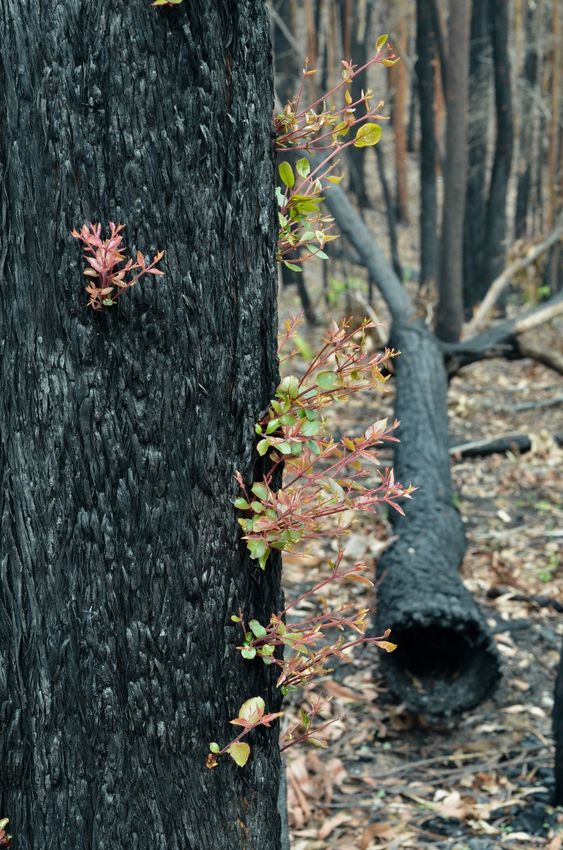
Epicormic regeneration in Eucalyptus on the South Coast of NSW ©Anne Kerle
Research for the Wildlife and Threatened Species Bushfire Recovery Expert Panel
Version 1.4
1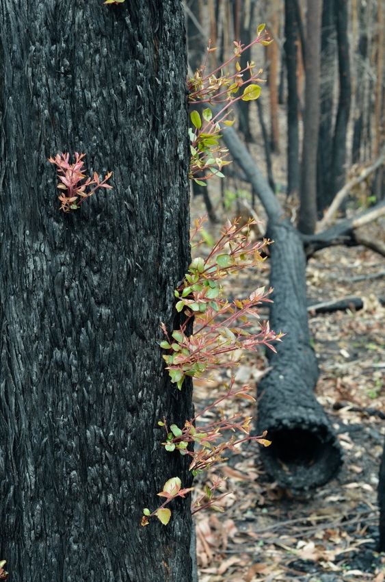
Citation: Gallagher RV. 2020. National prioritisation of Australian plants affected by the 2019-2020 bushfire season – Report
to the Commonwealth Department of Agriculture, Water and Environment.

Research prepared by Rachael Gallagher, Macquarie University (MU), with grateful assistance from those below.

The development of the prioritisation criteria (Appendix 1) was led by Tony Auld (NSW Department of Planning,
Industry & Environment - DPIE) with assistance from David Keith (DPIE/University of New South Wales -
UNSW), Berin Mackenzie (UNSW), Mark Ooi (UNSW), Tom Le Breton (UNSW) and Rachael Gallagher (MU).

Programming expertise was provided by Stuart Allen (MU) and Samuel Andrew (CSIRO).

Data resources were provided by Sue Fyfe (Department of Agriculture, Water and the Environment - DAWE),
Fiona Wood (DAWE), Jason Ferris (DAWE), Georgina Newton (DAWE), Ian Warren (DAWE), Bianca
Kallenberg (DAWE), Alexis McIntyre (DAWE), Robert Godfree (CSIRO), Nunzio Kerr (CSIRO), Linda
Broadhurst (CSIRO/Centre for Australian National Biodiversity Research - CANBR), Tony Auld, Berin
MacKenzie, David Keith, Mark Ooi, Matthew White (Vic - Department of Land, Water and Planning (DELWP),
Cory Merow (University of Connecticut - UC), Thymios Nikolopoulos (UC), Colin Yates (WA Department of
Biodiversity, Conservation and Attractions – DBCA), Carl Gosper (WA DBCA), Sarah Barrett (WA DBCA), Emer
O’Gara (WA DBCA), Daniel Falster(UNSW), Elizabeth Wenk (UNSW), Caitlin Baxter (UNSW), Michelle Waycott
(SA Herbarium), Katherine Berthon (RMIT), Michelle Leishman (MU), Linda Beaumont (MU), Kang He (UC),
Edward Liew (Royal Botanic Gardens & Domain Trust, Sydney - RBGDT), Angus Carnegie (NSW Department of
Primary Industries - DPI), Keith McDougall (DPIE), Robert Makinson (DPIE), Vanessa Adams (University of
Tasmania), Marco Duretto (RBGDT), Brett Summerell (RBGDT), Treena Burgess (Murdoch University) and Greg
Guerin (University of Adelaide).

Advice was provided during initial workshops among Australian plant researchers, initiated by Linda Broadhurst and
including Stephen van Leeuwen, Colin Yates (DBCA), Matthew White (DELWP), Anne Buchan (DELWP), Steven
Sinclair (DELWP), David Cantrill (Royal Botanic Gardens Victoria – RBGV), Samuel Andrew (CSIRO), Sarah
Legge (University of Queensland – UQ, Australian National University -ANU), Benjamin Miller (DBCA), Carl
Gosper (DBCA), Daniel Metcalfe (CSIRO), Jason Ferris, Robert Godfree, Tony Auld and David Keith.

Anne Kerle and Mike Fleming provided the front and back cover images.

The Bushfire Recovery Expert Panel and the Threatened Species Commissioner reviewed and refined the approach
and delivery of this research.

ABBREVIATIONS

ALA                 Atlas of Living Australia

APNI                Australian Plant Name Index

AusTraits           The AusTraits Plant Trait Database http://traitecoevo.github.io/austraits.build/

FFRD                NSW Fire Response database

NIAFED              National Indicative Aggregated Fire Extent Dataset

PAA                 Preliminary Analysis Area (IBRA regions)

SPRAT               Commonwealth Species Profile and Threats Database

APPENDICES

Appendix 1. Framework for prioritising impact assessments for plants following the 2019-2020 bushfires

Appendix 2. Final assessment by taxon. See FINAL_ASSESSMENT_Ver1_2.csv

Appendix 3. Metadata for column names in Appendix 2

Appendix 4. High priority taxa for recovery actions. See FINAL_PRIORITY_LIST_PLANTS_Ver1_2.csv

Appendix 5. Proposed management actions for all taxa assessed HIGH or MEDIUM risk. See
FINAL_MANAGEMENT_ACTIONS_BY_TAXON_Ver1_1.csv

                                                                                                                                2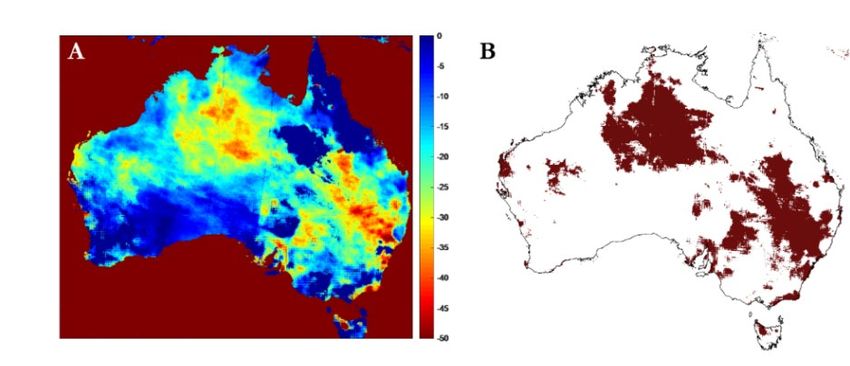
Summary
During the 2019-2020 bushfire season, over 10 million hectares of Australia burned. In the
aftermath, a continent-wide prioritisation was undertaken to identify which of Australia’s 26,062
plant taxa may be most at risk of impacts and extinction. This prioritisation was based on a set of
11 criteria (A-K) developed in consultation with experts in plant and fire ecology, led by Dr
Tony Auld of the NSW Department of Planning, Industry and Environment, and endorsed by
the Wildlife and Threatened Species Bushfire Recovery Expert Panel.
This Final Assessment refines and extends the methods applied in the Interim Assessment
Report ver. 1.4 (Gallagher 2020) by including an additional 7,058 plant taxa, new data on species
traits, and revised spatial analysis for several criteria. As previously, 1,335 plant taxa listed as
threatened under the Commonwealth Environmental Protection and Biodiversity Conservation Act 1999
(EPBC Act) and 4,622 listed under state legislation have been assessed. Burnt area statistics are
shown in Table ES1; 8% of EPBC Act taxa had more than 50% of their range burned during the
2019-2020 fire season.
Of the 26,062 plant taxa assessed, 486 were prioritised as requiring immediate action to assess
impacts and support recovery. These taxa had more than 80% of their range burnt, or were listed
as Endangered or Critically Endangered under the EPBC Act or state/territory listings, or were
listed as HIGH risk under two or more of the criteria assessed. Of these 486 high priority
species, 369 appeared in the Interim Assessment, and 117 and 102 have been gained and lost,
respectively. These changes in species identified as high priority are due to the inclusion of more
taxa, new trait data and refined threat information relative to the Interim Assessment.
Table ES1. Assessment of 26,062 Australian plant species distributions and their overlap with the National
Indicative Aggregated Fire Extent Database (NIAFED) within the Preliminary Analysis Area (PAA). The range of
values given reflects the use of multiple sources of distribution data for plant taxa.
 Taxon group*        Count    Plant taxa     Plant taxa        Plant taxa        Plant taxa with   Plant taxa with   Plant taxa with
                              with range     impacted by       impacted by       range > 90%       range > 50%       range > 30%
                              data           2019-2020 fires   2019-2020 fires   burnt             burnt             burnt
                              available      (%)               (count)
 EPBC Act             1335         1333            44%               585             35 (3%)           90 (7%)           148 (11%)

 NSW endemics         1320        1248          77 - 92%          956 – 1152      52-104 (4-8%)     306-311 (25%)    519-626 (42-50%)
 WA endemics          8952        8578          32 - 68%         2754 – 5822       4-10 (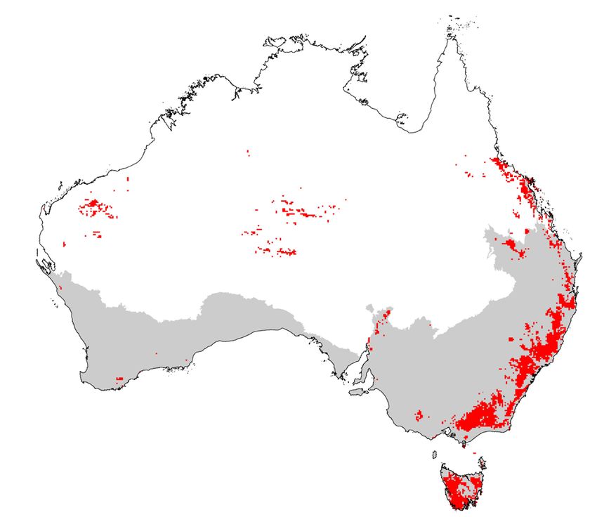
BACKGROUND
Over the 2019-2020 bushfire season, more than 10 million hectares of Australia burned. To
effectively manage the impact of this unprecedented bushfire season, affected species and
locations need to be prioritised based on objective criteria which capture inherent risk. This Final
Assessment provides a national scale analysis of the impact of the 2019-2020 bushfires and other
interacting threats, such as drought, disease and herbivory, on native Australian plant species.
Australian plant scientists have worked collaboratively to create both the framework for
prioritising impact assessments and the resources required to assess taxa presented in this report.
This Final Assessment is based on a suite of 11 criteria (A-K) which have been assessed across
26,062 plant taxa.

IDENTIFYING PRIORITY SPECIES
Large numbers of species were identified as at HIGH risk under one or more criteria in the
Interim Assessment. To further refine a list of priority taxa for funding and recovery actions, a
rule-set was developed with the Expert Panel as follows:
Priority species were either -
    (1) Listed as Critically Endangered or Endangered under the Environment Protection and
        Biodiversity Conservation Act 1999 (EPBC Act) or equivalent state legislation prior to the
        fires,
    (2) Burnt across 80% or more of their range burnt,
    (3) Ranked as HIGH risk under two or more prioritisation criteria requiring unique
        management actions.
Following the revised implementation of the prioritisation criteria (as described below), 486 taxa
met this rule set, which is a decrease of 9% relative to the Interim Assessment where 471 taxa
were prioritised. Of these 486 high priority species, 369 appeared in the Interim
Assessment, and 117 and 102 have been gained and lost, respectively. This decrease in
priority species reflects the refinement of trait data and spatial analysis products and approaches
used in this Final Assessment. Specific methods applied to each criterion are detailed below.
Taxa which are no longer included as high priorities are still considered at to be impacted, but
not to the degree which met the revised implementation of the prioritisation criteria.
Key revisions relative to the Interim Assessment are:
    -   Addition of 7,058 plant taxa – primarily those with distributions across state borders and
        species with informal manuscript names in the Australian Plant Census
    -   Increased breadth and quality of species data for traits such as resprouting capacity,
        obligate seeding, and woodiness
    -   Incorporation of new national fire severity data (Australian Google Earth Engine Burnt
        Area Map – AUS GEEBAM Fire Severity; DAWE 2020)
    -   Incorporation of spatial products approximating exposure to disease (myrtle rust and
        phytophthora) and feral herbivores (pigs, goats, horses, rabbits, deer)

                                                                                                     4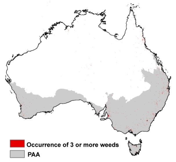
-   Revised approach to analysis of fire return time intervals incorporating landscape
         productivity and state agency datasets on fire history
     -   Incorporation of terrain characteristics in the assessment of erosion risk

THE PRIORITISATION FRAMEWORK
Framework development was led by Dr Tony Auld at NSW DPIE. The framework targets
species’ life-history traits that make plant species prone to population declines or local
extinctions if they occur within the spatial footprint of 2019-2020 bushfires. The identification of
species potentially at risk because of these fires involves three components:
1.       Identifying potential mechanisms of decline.
2.       Identifying where in the landscape these mechanisms are most likely to have an impact.
3.       Identifying the species and most exposed to risks associated with these mechanisms.
The Framework consists of eleven criteria (A-K) which are intended to identify plant species at
the greatest potential risk of population declines or local extinctions following the 2019-2020
bushfires and to prioritise such species for field impact assessments and actions.
A.       Interactive effects of fire and drought
B.       Short fire intervals (impacts of high fire frequency)
C.       Post-fire herbivore impacts
D.       Fire-disease interactions
E.       High fire severity
F.       Weed invasion
G.       Elevated winter temperatures or changed temperature regimes
H.       Fire sensitivity
I.       Post-fire erosion
J.       Cumulative exposure to high risks
K.       Other plausible threats or expert-driven nominations
The highest risk ranking obtained via any single criterion is determined to be the overall risk
ranking as the risk mechanisms may operate independently or interact in complex ways, and
hence the criteria are not additive. Species should be assessed against all criteria where possible.
Criteria A-J have been assessed in full for this report. States and territories provided lists of high
priority taxa from their own fire recovery work and these are listed under Criteria K.
Priorities for field inspections, monitoring and conservation action may be guided by a simple
categorisation of impact:

                                                                                                         5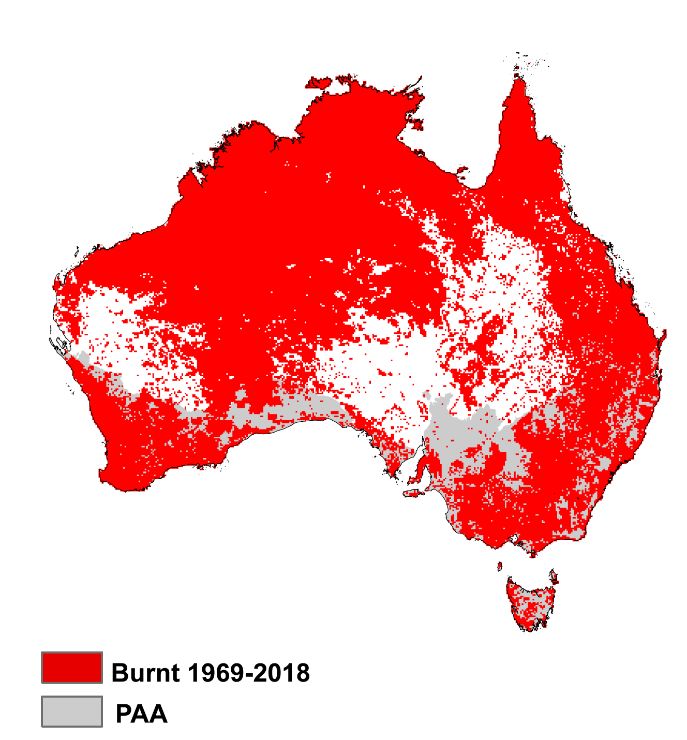
HIGH – Very likely at risk. Require an urgent assessment of initial impacts and post-fire
monitoring of recovery where impacts are significant.
MEDIUM – Likely to be at risk. Assessment of initial impacts and post-fire monitoring are
recommended.
LOW – Unlikely to be at risk. Post-fire monitoring may be conducted opportunistically during
sites visits or by other groups (externals, universities, citizen science).
NONE – Not known to be burnt in the 2019-2020 fires or not expected to be at risk.

BASELINE DATA USED IN ASSESSMENT
Taxonomy
Nomenclature follows the Australian Plant Census (accessed in June 2020 from
https://biodiversity.org.au/nsl/services/export/index).
Quantifying plant species ranges
The distributional range of plant taxa was estimated from multiple different resources:(1)
Cleaned occurrence records from the Australasian Virtual Herbarium (AVH;
https://avh.chah.org.au/); (2) Point process models of species range built from climate and soil
data; (3) ‘Range-bagging’ models built from climate and soil data; (4) Area of occupancy (AOO)
in a 2km x 2km grid resolution (IUCN 2019); and, for EPBC Act listed taxa, (5) DAWE
regulatory maps for Species of National Environmental Significance available from
https://www.environment.gov.au/science/erin/databases-maps/snes. Approaches (2), (3), and
(4) are collectively known as ‘modelled ranges’ hereafter.
Using a collection of approaches to quantify taxon ranges provides an estimate of the uncertainty
associated with different resources. The number of taxa with data in each taxon group are shown
in Table 1 (overleaf) and details for each taxon group stated below.

EPBC Act listed plant taxa
Ranges for this taxon group were quantified using range maps licensed from the Species and
Communities of National Environmental Significance Database maintained by DAWE
https://www.environment.gov.au/science/erin/databases-maps/snes. The full version of these
data were obtained and used under licence. These range maps are used to regulate the impacts on
taxa listed under the EPBC Act and were therefore considered to be the primary source of range
information for these taxa. The impact of fires on EPBC Act taxa what not assessed using
cleaned AVH records or modelled ranges.
State listed taxa, endemics and all other taxa
These groups include taxa: (1) listed as threatened under state legislation; (2) endemic to a single
state according to the APC; (3) all other taxa assessed. Note that species may overlap between
these categories (1) and (2) and those listed on the EPBC Act. Ranges for these taxa were
assessed using cleaned occurrence data from the AVH and modelled ranges. Point occurrence

                                                                                                       6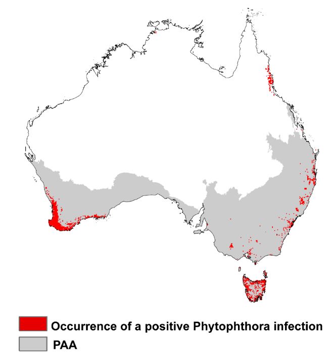
Table 1. Number of plant taxa with range data from three different sources: DAWE, Australian Virtual Herbarium,
and modelled ranges.

 Taxon group           Count               DAWE                   Clean AVH               Models of
                                           regulatory maps        occurrence              species range
                                                                  records
 EPBC Act                    1335                 1333                   1196                    1194
 NSW endemics                1320                 230                    1246                    1237
 WA endemics                 8952                 372                    8574                    8536
 Vic endemics                 408                  69                     361                    358
 SA endemics                  488                  65                     457                    457
 Qld endemics                3629                 209                    3431                    3420
 Tas endemics                 543                  74                     524                    521
 ACT endemics                  6                   2                       6                      6
 Listed threatened            700                 352                     629                    626
 in NSW
 Listed threatened            436                  391                    409                     409
 in WA
 Listed threatened           1770                  144                    1610                   1607
 in Vic
 Listed threatened            807                  111                    765                     763
 in SA
 Listed threatened            935                  268                    886                     883
 in Qld
 Listed threatened            460                   95                    424                     422
 in Tas
 Listed threatened             13                   11                     12                      12
 in ACT
 All other taxa              7976                   0                     7900                   7864

 Total                       26062                 1333                  24843                   24738

data (latitude and longitude coordinates) were downloaded from the Atlas of Living Australia
(ALA) application programming interface http://api.ala.org.au/ for all taxa listed in the
kingdom Plantae in December 2019. Occurrences were filtered to exclude any records of taxa
with no ratified name according to the Australian Plant Census (CHAH 2010) or of non-native
origin, or taxa with cultivated status, and/or flagged geographic issues in the ALA. Individual
records lacking a vouchered specimen for verification and/or collected prior to 1950 were also
excluded (Fig. 1).

                                                                                                              7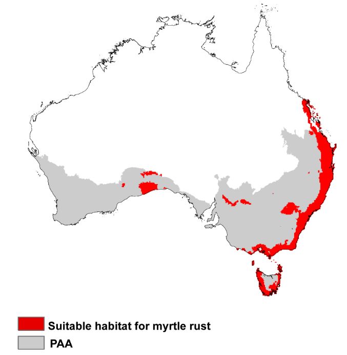
Figure 1. Number of vouchered specimens in the Australasian Virtual Herbarium (AVH) since 1900 with valid
latitude and longitude coordinates. Note that most collections occur after 1950.

Using these cleaned occurrences, species range maps were built from the environmental
conditions across the range of the taxa (climate and soils) using Poisson Point process modelling
(PPPM; (Warton & Shepherd 2010; Renner & Warton 2013) or, for a limited number of taxa,
range bagging (Drake 2015) or by calculating an area of occupancy (AOO). PPPMs were applied
to all taxa with 10 or more unique occurrence records at a 10km x 10km grid cell resolution and
were using regularized down-weighted Poisson regression based on 20,000 background (pseudo-
absence) points. Predictions were limited to a spatial domain that encompassed ecoregions from
Dinerstein et al. (2017) occupied by the species across its Australian range.
PPPMs and range bagging were trained on mean annual temperature (°C), mean diurnal
temperature range (°C), annual precipitation (mm), precipitation seasonality (coefficient of
variation), annual mean radiation (W m-2), aridity index, bedrock depth (m), soil bulk density
(fine earth) in kg/m3, clay mass fraction (%), silt mass fraction (%), and pH. These climate and
soil factors were chosen as they reflect major abiotic factors shaping plants growth and nutrition
and have correlation coefficients of < 0.7. Variable choice optimised to individual species or
clades may refine predictions (Elith et al. 2010). Climate data was accessed from WordClim2
(Fick & Hijmans 2017) http://www.worldclim.org/v2/, except for aridity which was created by
at CGIAR Consortium for Spatial Information (CGIAR-CSI) and accessed at
https://cgiarcsi.community/data/global-aridity-and-pet-database/. Gridded soil data is
described in Hengl et al. (2017) and provided by International Soil Reference and Information
Centre at https://www.isric.org/explore/soilgrids. Soil data was averaged across the top 30cm
of the soil profile and aggregated to 10km x 10km grid cell resolution.
PPM models were evaluated using the area under the curve (AUC) statistic which was, on
average, 0.81 (s.d. 0.16). The mean partial AUC evaluated over a range of sensitivity relevant for
SDM (0.8-0.95) was 0.82 (s.d. 0.06). The mean sensitivity of binary maps used to assess range
overlap (based on the 5% training threshold used to make a binary map) was 0.79 (s.d. 0.09).
Small sample sizes make range bagging models difficult to meaningfully evaluate, though the
mean training AUC (cross-validation not performed due to small sample size) was 0.92 (0.09
s.d.).

                                                                                                            8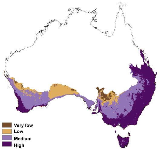
Fire extent
The National Indicative Aggregated Fire Extent Database (NIAFED) was used to quantify the
extent of the 2019-2020 bushfire season
http://www.environment.gov.au/fed/catalog/search/resource/details.page?uuid=%7B9ACDC
B09-0364-4FE8-9459-2A56C792C743%7D; Fig. 2). The NIAFED layer was only applied within
the Preliminary Analysis Area (PAA; Fig. 2) as recommended by the Expert Panel.

Figure 2. National Indicative Aggregated Fire Extent Database (NIAFED) was used to quantify the extent of the
2019-2020 bushfire season inside the Expert Panel Preliminary Analysis Area (PAA).

The NIAFED layer has several known issues which should be considered interpretation. These
include (according to the metadata record for the dataset):
“1. The dataset draws data together from multiple different sources, including from state and
territory agencies responsible for emergency and natural resource management, and from the
Northern Australian Fire Information website. The variety of mapping methods means that
conceptually the dataset lacks national coherency.
2. The limitations associated with the input datasets are carried through to this dataset. Users are
advised to refer to the input datasets’ documentation to better understand limitations.
3. The dataset is intentionally precautionary and the rulesets for its creation elect to accept the
risk of overstating the size of particular burnt areas. If and when there are overlapping polygons
for an area, the internal boundaries have been dissolved.
4. The dataset shows only the outline of burnt areas and lacks information on fire severity in
these areas, which may often include areas within them that are completely unburnt. For the
intended purpose this may limit the usability of the data, particularly informing on local
environmental impacts and response. This issue will be given priority, either for future versions
of the dataset or for development of a separate, but related, fire severity product.
5. This continental dataset includes large burnt areas, particularly in northern Australia, which
can be considered part of the natural landscape dynamics. For the intended purpose of

                                                                                                                9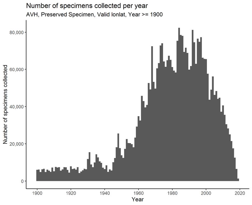
informing on fire of potential environmental impact, some interpretation and filtering may be
required. There are a variety of ways to do this, including by limiting the analysis to southern
Australia, as was done for recent Wildlife and Threatened Species Bushfire Recovery Expert
Panel’s preliminary analysis of 13 January 2020. For that preliminary analysis area, boundaries
from the Interim Biogeographic Regionalisation of Australia version 7 were used by the
Department to delineate an area of southern Australia encompassing the emergency bushfire
areas of the southern summer. The Department will work in consultation with the expert panel
and other relevant bodies in the future on alternative approaches to defining, spatially or
otherwise, fire of potential environmental impact.
6. The dataset cannot be used to reliably recreate what the national burnt area extent was at a
given date prior to the date of release. Reasons for this include that information on the date/time
on individual fires may or may not have been provided in the input datasets, and then lost as part
of the dissolve process discussed in issue 2 above.
7. Fire extents are downloaded daily and datasets are aggregated. This results in an overlap of
polygon extents and raises the issue that refined extents are disregarded at this early stage.”

Caveats for interpreting burnt area statistics
Multiple types of distribution data were used to estimate burnt area for all taxa: herbarium
records, range maps and - for EPBC Act listed taxa - DAWE regulatory maps. As a precaution,
the largest estimate of area burnt was used to assess taxa against the prioritisation framework. All
sources of data have known issues, including:
- Distributional ranges estimated from herbarium collection data may underestimate the full
extent of known occurrences for a taxon due to sparse sampling across the range. This
underestimation may be more pronounced for taxa with manuscript names (i.e. new taxa without
databased records) or for taxa which are difficult to detect in the field. Other sources of
occurrence data may be available from state agencies which may alter burnt area statistics. The
likelihood of an omission error (underestimation of range) may increase as true range size
decreases. The use of state agency databases of occurrence information was investigated for both
NSW and WA, though was considered to duplicate resources already provided for the Interim
Assessment or to have significant issues with taxonomy (J. Renwick and T. Auld pers. comm.).
- Modelled ranges are prone to two styles of potential error: (1) commission errors
(overestimation of range size) as environmental conditions at known sites are extrapolated across
space; and (2) omission errors resulting from occurrence data which may poorly represent the
range of species where sampling is inadequate or biased.
- DAWE maps of Species of National Environmental Significance are, in some instances,
precautionary in their estimation of species ranges.
- DAWE maps may also not capture the full known extent of distributions for some species.
This is not unique to this source of range data, but as DAWE maps were preferred over other
sources of burnt area data for EPBC Act taxa some species may have their impact
underestimated. This is a known issue for some species of national significance in the Stirling
Ranges National Park in Western Australia.

                                                                                                  10
PROPOSED MANAGEMENT ACTIONS FOR EACH CRITERIA
Management actions are provided for all criteria and are grouped into three types:
• Immediate – essential actions to undertake in the short-term
• Measured – to be undertaken before the 2020-2021 fire season, where feasible
• Universal – actions which should be applied when managing threatened or sensitive
species against a background suite of potential threats
Most actions allow the gathering of specific evidence on population size and inferred or
continuing threats and/or decline which is required to list species under Commonwealth, state
and territory threatened species legislation using IUCN Red List criteria. It is intended that the
immediate management actions scored against each taxon in Appendix 5 will guide the
prioritisation of recovery actions. Management actions for each criterion are outlined in Table 2.
Management actions were assigned to species based on their ranking scores and therefore do not
include advice from management staff who can provide more nuanced understanding of
priorities for on-ground actions.
11Table 2. Proposed management actions for taxa listed under the prioritisation criteria. Actions are listed as immediate, measured (before the 2020-
2021 fire season, where feasible) and universal.
Criteria
Urgency of
A B C D E F G H I J
Management Action action
Field inspections – damage and threats Immediate
Germplasm collection Immediate
Field inspections - resprouting assessment Immediate
Field inspections - seedling emergence assessment Immediate
Disease – field assessments and emergency germplasm
collection of cuttings where resprouting is affected Immediate
Exclude forestry impacts Immediate
Alleviate herbivory Immediate
Field inspections - recovery assessment Medium-term
Irrigation Medium-term
Weed control Medium-term
Exclude prescribed fire Medium-term
Rapid response to wildfire Medium-term
Carefully-planned translocation Medium-term
Alleviate pollinator competition from feral bees and Medium-term
European wasp / Ongoing
Minimise mining impacts Ongoing
Illegal collecting or over-collecting of germplasm or plants Ongoing
Habitat disturbance from human activities Ongoing
Criteria are: A Interactive effects of fire and drought; B Short fire intervals (impacts of high fire frequency); C Post-fire herbivore impacts; D Fire-disease interactions; E High fire
severity; F Weed invasion; G Elevated winter temperatures or changed temperature regimes; H Fire sensitivity; I Post-fire erosion; J Cumulative exposure to high risks. Note that
species listed under Criterion K will likely need some of the management actions outlined as well as actions identified by experts nominating the taxa.
Management actions are: Immediate actions are essential actions to undertake in the short-term; Medium-term actions are to be undertaken before the 2020-2021 fire season;
Ongoing actions should be universally applied when managing threatened or sensitive species against a background suite of potential threats
12GENERAL RECOMMENDATIONS
1. Actions undertaken towards recovery should not jeopardise species. For instance,
strict hygiene protocols should be obeyed when visiting sites to avoid the spread of plant
diseases or weed propagules. It is critically important to allow natural systems to recover
after fire without seeding or planting interventions in the immediate to medium term.
Post-fire recovery can take months or years (and even longer for some species) and will
depend on certain environmental conditions. The focus in the first 12 months after the
fires should be on eliminating threats to natural recovery rather than on translocation
(which itself needs to be carefully planned).
2. Germplasm collection should be limited to species at immediate risk of local
extinction. Significant collecting of seed may jeopardise the replenishment of seedbanks
and there should be no seed collection for any species until its seed bank has been
sufficiently replenished to enable population recovery in the event of a
subsequent fire. The resilience of many species to fire is dependent upon the
maintenance of persistent soil or canopy seed banks. Seed banks allow post-fire seedling
recruitment and the magnitude of the seed bank (along with fire-related factors such as
heat and smoke) and post-fire rainfall govern the magnitude of post-fire seedling
recruitment. Canopy seed banks may be exhausted by a single fire (where all plants are
burnt). Soil seed banks likely provide some buffer against successive fires due to residual
seeds surviving in the soil after a fire without germinating, but soil seed banks too can be
exhausted in a single fire. For population persistence, seed banks need to be sufficiently
replenished after a fire and before the next fire occurs. While the length of time required
varies between species, an approximation is to allow three times the primary juvenile
period between fires. Seed collection (e.g. for ex situ conservation or other restoration
activities) prior to adequate post-fire replenishment of in situ seed banks may limit
species’ persistence capacity, especially as more frequent fire is predicted under a
changing climate. Cases of urgent ex situ conservation may be an exception, in which
case seed collection should be carried out to minimise impacts on in situ seed bank
accumulation in accordance with collection guidelines for threatened plant species.
3. Translocation needs to be well-planned and appropriate. Seed addition and
supplementary planting (translocations) should only be considered (as a long-term
option) if it is demonstrated that species fail to recover effectively at a site. Decisions to
proceed with translocation should be based on rigorous post-fire site assessments of
recovery and should follow appropriate national guidelines on translocation (ANPC
2019).
4. All taxa in high and medium categories require inspections at some time to
assess active threats. The spatial analysis and trait-based approach applied in this
prioritisation will not identify all threats present across the range of a species. Appendix 5
provides a list of all HIGH and MEDIUM ranked taxa and their associated management
actions.
135. Planned recovery actions should be made with reference to the Prioritisation
Framework. The criteria in the Prioritisation Framework reflect the need to collect data
on information which is required for statutory listing of taxa, particularly under IUCN
Red list criteria adopted under Commonwealth, state and territory threatened species
legislation (e.g. population size, threat information, decline).
APPLICATION OF THE PRIORITISATION FRAMEWORK
Each criterion, methods used to assess and risk categorisation across taxon cohorts (EPBC Act
listed species, state listed species, state endemics and all other taxa) are detailed below. All taxon
level data, including proportion of range burnt and assessment against each criterion are available
in Appendix 2 (see Appendix 3 for an explanation of column names).
Summary tables of burnt area statistics and risk categories
Table 3 details the extent of range burnt across 26,062 taxa in the 2019-2020 bushfire season.
Table 4 shows which criteria are contributing to the greatest number of high risk classifications.
Table 3. Intersection of species ranges against National Indicative Aggregated Fire Extent Database (NIAFED)
layer within the Preliminary Analysis Area (PAA). Ranges of EPBC Act taxa were quantified using the DAWE
regulatory maps only. All other taxa were assessed against both cleaned AVH occurrence data and modelled ranges
where available. The range of values given reflect the use of these different range size estimates. For % of taxa with
range > 30, 50 or 90% burnt, this is a percentage of the total number of taxa with data available e.g. 35/1333 = 3%.
Note that this table does not contain 20 species listed under Criterion K which were identified in consultation with
state agencies after conclusion of the Interim Assessment.
Taxon group Count Plant taxa Plant taxa Plant taxa Plant taxa with Plant taxa with Plant taxa with
with range impacted by impacted by range > 90% range > 50% range > 30%
data 2019-2020 fires 2019-2020 fires burnt burnt burnt
available (%) (count)
EPBC Act 1335 1333 44% 585 35 (3%) 90 (7%) 148 (11%)
NSW endemics 1320 1248 77 - 92% 956 – 1152 52-104 (4-8%) 306-311 (25%) 519-626 (42-50%)
WA endemics 8952 8578 32 - 68% 2754 – 5822 4-10 (Table 4. Numbers of taxa and their ranking under each of eleven criteria in the prioritisation
Criteria A B C D E F G H I J K Total
High 235 147 97 186 258 3 9 13 4 291 35 831
Medium 340 485 47 444 474 8 19 23 17 593 0 1915
Low 10375 14718 4820 3117 16080 11859 235 332 5766 1806 0 16862
None 14102 9498 14425 17537 8240 13182 25654 25693 19265 8543 0 26062
Data 1010 1214 6673 4778 1010 1010 145 1 1010 14829 26027 26055
deficient
CRITERION A. Interactive effects of fire and drought
Pre-fire drought can: i) reduce internally stored resources of resprouter plants that are critical in
sustaining post-fire regeneration; and ii) reduce pre-fire reproductive output, impacting on the
size of the seed bank available for post-fire recruitment.
Post-fire drought can negatively impact post-fire recruitment success by reducing seed
germination (due to insufficient soil moisture; possibly causing seed mortality in some dormancy
types), seedling survival (through desiccation) and survival of resprouts (through xylem
embolism in susceptible new shoots). Risks to mortality may be large if drought occurs in the
first autumn-winter after fire or the following spring-summer.
1) HIGH – Species with > 50% known sites or habitat burnt in the 2019-2020 fires AND evidence or
likelihood of either:
a) Significant pre-fire drought; OR
b) Incidence of post-fire drought within 18 months of the 2019-2020 fires.
2) MEDIUM – Species with > 30 to < 50% known sites or habitat burnt in the 2019-2020 fires AND
evidence or likelihood of either:
a) Significant pre-fire drought; OR
b) Incidence of post-fire drought within 18 months of the 2019-2020 fires.
3) LOW – Species with > 0 to < 30% known sites or habitat burnt in the 2019-2020 fires AND evidence
or likelihood of either:
a) Significant pre-fire drought; OR
b) Incidence of post-fire drought within 18 months of the 2019-2020 fires.
4) NONE – Either:
a) No known sites or habitat burnt in the 2019-2020 fires; OR
b) No evidence or likelihood of pre- or post-fire drought impacts in any known sites or habitat.
Methods
Pre-fire drought was assessed by intersecting species range data with mapping of the
accumulated severity of drought conditions in the 12 months prior to December 2019. The 12-
month time period captures conditions during the previous growing season and was mapped as
the accumulated severity of drought based on the Standardised Precipitation Index (SPI) (McKee
et al. 1993). The SPI is defined as the number of standard deviations that observed cumulative
precipitation deviates from the average.
Raw data values for accumulated drought severity were classified into four equal-sized bins
across Australia (Figure 3). The upper quartile was assumed to adequately represent areas of
significant pre-fire drought and was intersected with species range datasets.
15Figure 3. (A) Continuous raw data values of accumulated severity of drought conditions for December 2019
according to the Standardised Precipitation Index (SPI). Lower values denote more severe drought conditions; (B)
Classification of areas of significant pre-fire drought conditions used to assess against Criterion A.
Assessment outcome
Accumulated drought severity, fire extent mapping and distributional range data were combined
to assess against the criterion.
Table 5. Number of taxa in each risk category under Criterion A - Interactive effects of fire and drought
Data
Taxon group HIGH MEDIUM LOW NONE
deficient
EPBC Act 29 23 230 1051 2
State listed NSW 39 39 382 196 44
State listed WA 0 0 12 422 2
State listed Vic 41 53 1180 343 153
State listed SA 0 1 540 228 38
State listed Qld 3 5 209 682 36
State listed Tas 2 7 274 151 26
State listed ACT 0 0 5 8 0
NSW endemics 151 196 674 227 72
WA endemics 1 0 2261 6316 374
SA endemics 0 0 232 225 31
Vic endemics 16 7 113 226 46
Qld endemics 3 6 833 2594 193
Tas endemics 0 0 166 359 18
ACT endemics 0 0 2 4 0
All other taxa 25 70 4261 3613 7
Total* 235 340 10375 14102 1010
* Taxa may be shared between taxon groups and the total is the number of unique species across taxon groups
which are listed under each risk category.
16PROPOSED MANAGEMENT ACTIONS
Species assessed HIGH or MEDIUM risk under Criterion A (Table 5) are at specific risk from:
- Pre-fire drought affecting post-fire resprouting ability, especially where the 2019/2020
fires were of high severity.
- Post-fire drought conditions affecting seedling recruitment success and resprouting
capacity.
Immediate actions
Field inspections – resprouting: Inspections to quantify the number of plants resprouting and
the survival of resprouted tissue.
Field inspections – seedling emergence: For obligate seeding species, field inspections to
quantify seedling emergence and survival.
Exclude forestry impacts: Enforcement of buffers, surveys of burnt production forests to
detect threatened taxa at appropriate time intervals and use of education and liaison to minimise
any damage of logging activities to post-fire recovery.
Medium-term actions
Exclude prescribed fire: prescribed burning should be excluded from sites burnt in the last 5
years for non-woody taxa; the last 15 years for woody taxa; or the last 50 years for species which
are killed by fire or are long-lived and prone to basal charring.
Ensure rapid response to wildfire: any future wildfires that threaten to burn over recovering
sites should be rapidly extinguished.
Irrigation: investigate the feasibility of supplementary watering during plant establishment.
Carefully planned translocation: addition of seed or individual plants propagated ex-situ to
populations where recovery is absent or inadequate to allow for species to avoid long-term
decline. Requires a thorough independent assessment of feasibility and likelihood of success.
Ongoing actions
Prevent illegal collecting or over-collecting of germplasm or plants: minimise illegal losses
via quarantine, other access management, education, fencing, surveillance and enforcement.
Habitat disturbance from human activities: Exclusion of vehicles, bikes and other human
disturbance via signage, fencing and negotiations with local users. Prevention of further
disturbance via fencing, liaison with relevant utility owners and land managers, and education
activities.
Minimise mining impacts: consideration of bushfire recovery in planning, assessment and
enforcement.
17CRITERION B. Short fire intervals (impacts of high fire frequency)
Exposure to short temporal intervals between successive fires can disrupt the replenishment of
seed banks which are essential to post-fire recruitment and population persistence. Species most
susceptible include obligate seeders (species that lack regenerative organs and rely entirely on
seed germination for post-fire recovery) and resprouters (species with the capacity to generate
new shoots from dormant buds post-fire) that suffer high mortality rates. The time required to
replenish seed banks post-fire varies. For most species, up to 15 years between successive fires is
needed to ensure that a seed bank is sufficiently replenished to maintain future post-fire
populations, although some trees (for example) may require longer fire-free periods.
Short intervals between fires may also kill juveniles of resprouting plants before they become
large enough to survive subsequent fires. The species that are most susceptible to these risks are
resprouters that are slow to develop regenerative structures (i.e. lignotubers, thick bark, rhizomes
etc.) or slow to replace mortality due to low fecundity. At least 15 years between successive fires
is needed to ensure the juveniles of most plant species can develop their fire-regenerative organs,
although some species such as mallee eucalypts may require at least 25 years.
Finally, some long-lived trees may suffer basal scarring where fires (or other factors related to
fires such as falling trees or limbs) damage and/or kill bark tissue. This enables subsequent fires
to smoulder into heartwood and weaken the structural integrity of the tree, causing mortality,
collapse and structural change to the ecosystem. Trees with thin bark are most prone to this
impact and replacement depends on fecundity and growth rates. Many rainforest trees and some
eucalypts are susceptible and are likely to require at least 50 years between successive fires to
enable partial recovery and replacement.
1) HIGH – > 25% known sites or habitat both:
a) burnt in 2019-2020 AND
b) experienced > 1 fire(s) within either:
i) the past 5 years for non-woody species; OR
ii) the past 15 years for woody species (excluding long-lived trees prone to
collapse from basal charring); OR
iii) the past 50 years for long-lived trees prone to collapse from basal charring.
2) MEDIUM – > 10% to < 25% known sites or habitat both:
a) burnt in 2019-2020 AND
b) experienced > 1 fire(s) within either:
i) the past 5 years for non-woody species; OR
ii) the past 15 years for woody species (excluding long-lived trees prone to
collapse from basal charring); OR
iii) the past 50 years for long-lived trees prone to collapse from basal charring.
3) LOW – > 0% to < 10% known sites or habitat both:
a) burnt in 2019-2020 AND
b) experienced > 1 fire(s) within either:
i) the past 5 years for non-woody species; OR
ii) the past 15 years for woody species (excluding long-lived trees prone to
collapse from basal charring); OR
iii) the past 50 years for long-lived trees prone to collapse from basal charring.
4) NONE – Either:
a. No known sites or habitat burnt in the 2019-2020 fires
b. Non-woody species with none of the known sites or habitat burnt in the 2019-2020 fires also
burnt by one or more previous fires in the past 5 years; OR
c. Woody species (excluding long-lived trees prone to collapse from basal charring) with none
of the known sites or habitat burnt in the 2019-2020 fires also burnt by one or more
previous fires in the past 15 years; OR
18d. Long-lived trees prone to collapse from basal charring with none of the known sites or
habitat burnt in the 2019-2020 fires also burnt by one or more previous fires in the past 50
years.
Methods
Trait data
Growth form data for all species was accessed from the AusTraits database
http://traitecoevo.github.io/austraits.build/ and used to characterise species as ‘woody’ or ‘non-
woody’ as follows:
Growth form Class
Herb non-woody
Shrub woody
Tree woody
Climber (case dependent)
Shrub/Tree woody
Subshrub woody
Graminoid non-woody
Epiphyte non-woody
Parasite non-woody
Aquatic non-woody
Palm non-woody
Climber/Herb non-woody
Climber/Shrub woody
Climber/Tree woody
Fern non-woody
Geophyte non-woody
Herb/Shrub woody
Growth form data in AusTraits is largely sourced from published floras for each state and the
Flora of Australia Online http://www.anbg.gov.au/abrs/online-resources/flora/main-query-
styles.html.
Fire history data
Multiple resources were combined to produce a single fire history layer for Australia (Fig. 4).
These resources are:
(1) Mapping from the Global Fire Atlas https://www.globalfiredata.org/fireatlas.html for
years 2003-2016. The Global Fire Atlas tracks the daily dynamics of individual fires to
determine the timing and location of ignitions, fire size and duration, and daily expansion,
fire line length, speed, and direction of spread. Methods are detailed in Andela et al.
19(2019). These methods were also used to map data on extent in each annual fire season
between 2017-2020 (Kang He, unpublished data).
(2) NSW National Parks and Wildlife Service Fire History – Wildfire and Prescribed Burns
dataset https://data.nsw.gov.au/data/dataset/1f694774-49d5-47b8-8dd0-77ca8376eb04.
This dataset shows areas burnt since 1903 across NSW and has known limitations to its
use in some parts of the state (e.g. Western Division) which fall largely outside the PAA.
(3) Victorian Department of Environment, Land, Water and Planning Fire History dataset
provided under license.
(4) Western Australian Department of Biodiversity, Conservation and Attractions Fire
History dataset (1969-2020) provided under license. In non-forested areas of WA (e.g.
Great Western Woodlands, arid zone and south coast) precise dates of fire are unknown
for the period 1969-70 and overall coverage of fire history mapping is likely to be less
accurate on private lands (C. Gosper pers. comm.).
Figure 4. Areas burnt between 1969 and 2020 from multiple sources: (1) remotely sensed mapping of fire extent
from the Global Fire Atlas, (2) the NPWS Fire History – Wildfire and Prescribed Burns dataset for NSW, (3)
DELWP Victoria Fire History dataset, and (4) WA DBCA Fire History dataset.
Short fire interval assessment
Data on traits and fire history were combined with information on the productivity of Australian
vegetation to produce an estimate of appropriate fire return times across the PAA. Specifically, a
spatial layer of the estimated Gross Primary Productivity (GPP, g C m-2 year-1) of vegetation
calculated using a Vegetation Photosynthesis Model (VPM) at spatial resolution (0.05 degree)
was accessed from Zhang et al. (2017) (Fig. 5). Raw values of GPP were classified into four
categories based on quartiles (extremely low, low, medium, high) and fire return times were
estimated for each category based on a review of the literature as follows:
20GPP category Woody species Non-woody species
Extremely low 25 years 12 years
Low 20 years 10 years
Medium 15 years 8 years
High 10 years 5 years
Return times required for regeneration of some woody taxa in high GPP areas may be longer
than 10 years, particularly for fire sensitive eucalypts and slow growing taxa.
All areas classified as the Major Vegetation Grouping ‘Rainforest’ in the National Vegetation
Inventory System were excluded from this analysis and assumed to have inappropriate fire
regimes if burnt at any time since 1969.
Figure 5. Four categories of vegetation productivity across the PAA based on quartiles of Gross Primary
Productivity (GPP). Raw data on GPP sourced from Zhang et al. (2017).
Fire return times based on GPP were combined with fire history data to create a spatial layer of
all locations where the interval between the 2019-2020 fires and the previous recorded fire was
too short to accommodate plant regeneration. Separate layers were generated for woody or non-
woody return times. Species range data was then intersected with the spatial layers of fire
intervals to assess the proportion of the range which is exposed to inappropriately short fire
return times.
Assessment outcome
Data on fire history, 2019-2020 fire extent, traits and distributional range were combined to
assess against the criterion.
21Table 6. Number of taxa in each risk category under Criterion B - high fire frequency
Data
Taxon group HIGH MEDIUM LOW NONE
deficient
EPBC Act 25 42 338 928 2
State listed NSW 30 59 398 167 46
State listed WA 0 2 111 321 2
State listed Vic 11 54 1300 249 156
State listed SA 1 1 541 224 40
State listed Qld 5 23 261 609 37
State listed Tas 0 2 277 153 28
State listed ACT 0 0 5 8 0
NSW endemics 107 261 674 203 75
WA endemics 6 31 5183 3349 383
Vic endemics 9 11 199 141 48
SA endemics 1 0 184 272 31
Qld endemics 5 15 1684 1716 209
Tas endemics 0 0 17 505 21
ACT endemics 0 0 1 5 0
All other taxa 12 96 4856 2838 174
Total* 147 485 14718 9498 1214
*Taxa may be shared between taxon groups and the total is the number of unique species across taxon groups which
are listed under each risk category.
PROPOSED MANAGEMENT ACTIONS
Species assessed HIGH or MEDIUM risk under Criterion B (Table 6) are at specific risk from:
- Short fire return cycles which eliminate regenerating plants. Many of the populations of
obligate seeding species must mature and replenish seedbanks before further fires lead to
local declines and possibly local extinctions. Short intervals between fires may also kill
juveniles of resprouting plants before they become large enough to survive subsequent
fires.
Immediate actions
Field inspections to assess resprouting: Inspections to quantify the number of plants
resprouting and the survival of resprouted tissue.
Field inspections to assess seedling emergence: For obligate seeding species, inspections to
quantify seedling emergence and survival.
Exclude forestry impacts: Enforcement of buffers, surveys of burnt production forests to
detect threatened taxa at appropriate time intervals and use of education and liaison to minimise
any damage of logging activities to post-fire recovery.
22Alleviate herbivory: exclusion or removal of feral grazers, stock and excessive native herbivores
by fencing and feral animal control.
Medium-term actions
Exclude prescribed fire: prescribed burning should be excluded from sites burnt in the last 5
years for non-woody taxa; the last 15 years for woody taxa; or the last 50 years for species which
are killed by fire or are long-lived and prone to basal charring.
Ensure rapid response to wildfire: any future wildfires that threaten to burn over recovering
sites should be rapidly extinguished.
Carefully planned translocation: addition of seed or individual plants propagated ex-situ to
populations where recovery is absent or inadequate to allow for species to avoid long-term
decline. Requires a thorough independent assessment of feasibility and likelihood of success.
Ongoing actions
Prevent illegal collecting or over-collecting of germplasm or plants: minimise illegal losses
via quarantine, other access management, education, fencing, surveillance and enforcement.
Habitat disturbance from human activities: Exclusion of vehicles, bikes and other human
disturbance via signage, fencing and negotiations with local users. Prevention of further
disturbance via fencing, liaison with relevant utility owners and land managers, and education
activities.
Minimise mining impacts: consideration of bushfire recovery in planning, assessment and
enforcement.
CRITERION C. Post-fire herbivore impacts
Plants are often at their most palatable and least resilient to herbivore activity (e.g. leaf and shoot
removal, trampling and substrate degradation) in the post-fire environment where herbivores
have enhanced foraging efficiency and converge on regenerating burnt areas to exploit fresh
growth. Concentrations of herbivores may therefore increase mortality of both seedlings and
resprouters of palatable plants. In some cases, elevated mortality may lead to local extinction.
Effects may be exacerbated when burnt patches are small or have high perimeter to area ratios
which promote herbivore incursions in high densities.
1) HIGH – Evidence or likelihood of significant post-fire grazing impacts AND > 50% known sites or
habitat burnt in the 2019-2020 fires.
2) MEDIUM – Evidence or likelihood of significant post-fire grazing impacts AND obligate seeder with
> 30 to < 50% known sites or habitat burnt in the 2019-2020 fires.
3) LOW – Evidence or likelihood of significant post-fire grazing impacts AND either:
a) Obligate seeder with > 0 to < 30% known sites or habitat burnt in the 2019-2020 fires; OR
b) Resprouter with > 0 to < 50% known sites or habitat burnt in the 2019-2020 fires.
4) NONE – Either:
a) No known sites or habitat burnt in the 2019-2020 fires; OR
b) No evidence or likelihood of significant post-fire grazing impacts in any known sites or
habitat.
23Methods
This criterion was assessed using spatial data on the likely distribution of five non-native
mammal species which are known to cause significant impacts to plant species across their range:
horse (Equus caballus), pig (Sus scrofa), goat (Capra hircus), deer (various species) and rabbit
(Oryctolagus cuniculus). National mapping of the distributional range of all herbivores was accessed
from https://pestsmart.org.au/national-mapping-pest-animals-abundance-part1/ and sourced by
DAWE. Range maps were combined to create a single spatial layer detailing the number of feral
herbivore species (0-5) presumed present in each 10km x 10km grid cell across the PAA (Fig. 6).
Taxa with >50% of their range burnt and four or more feral herbivores mapped as likely to be
present across these burnt areas were classified as HIGH risk. MEDIUM and LOW risk taxa had
30-50% and 10-30% of range burnt plus four feral herbivores likely present in these areas,
respectively.
Spatial data on occurrence ca provide a broad perspective on the potential exposure of
herbivores, however expert knowledge of on-ground impacts should also be considered when
designing post-fire management actions. This may consider the palatability of species and likely
requires field assessment to verify.
Figure 6. Areas where ≥ 4 feral herbivores (horse, pig, goat, deer or rabbit) are present based on mapping of
potential distributions. Raw data accessed from: https://pestsmart.org.au/national-mapping-pest-animals-
abundance-part1/
24Assessment outcome
Data on feral herbivore distributions, 2019-2020 fire extent, and distributional range were
combined to assess against the criterion.
Table 7. Number of taxa in each risk category under Criterion C - Post-fire herbivore impacts
Data
Taxon group HIGH MEDIUM LOW NONE
deficient
EPBC Act 17 14 105 1066 133
State listed NSW 27 16 171 224 262
State listed WA 0 0 3 404 29
State listed Vic 22 18 901 408 421
State listed SA 0 0 323 302 182
State listed Qld 1 4 48 763 119
State listed Tas 0 0 208 156 96
State listed ACT 0 0 3 6 4
NSW endemics 54 18 427 257 564
WA endemics 1 0 740 5366 2845
Vic endemics 7 1 129 181 90
SA endemics 0 0 56 358 74
Qld endemics 1 0 73 3040 515
Tas endemics 0 0 11 505 27
ACT endemics 1 0 1 3 1
All other taxa 10 7 2178 4034 1747
Total* 97 47 4820 14425 6673
*Taxa may be shared between taxon groups and the total is the number of unique species across taxon groups which
are listed under each risk category.
PROPOSED MANAGEMENT ACTIONS
Species assessed HIGH or MEDIUM risk under Criterion C (Table 7) are at specific risk from:
- Browsing or grazing of regenerating tissues by herbivores which reduces the likelihood
of successful recovery
- Trampling of emerging seedlings and associated habitat damage
Immediate actions
Field inspections – damage and threats: to quantify the damage to standing or recovering
plants from the fires or from other threats (e.g. herbivory, disease, weed invasion, erosion).
Alleviating herbivory: exclusion or removal of feral grazers, stock and excessive native
herbivores by fencing and feral animal control.
25Germplasm collection: during field inspections, germplasm collection of seeds and/or cuttings
for species at immediate risk of local extinction should be conducted to preserve the species in
ex-situ cultivation and allow for reintroduction.
Medium-term actions
Exclude prescribed fire: prescribed burning should be excluded from sites burnt in the last 5
years for non-woody taxa; the last 15 years for woody taxa; or the last 50 years for species which
are killed by fire or are long-lived and prone to basal charring.
Ensure rapid response to wildfire: any future wildfires that threaten to burn over recovering
sites should be rapidly extinguished.
Carefully planned translocation: addition of seed or individual plants propagated ex-situ to
populations where recovery is absent or inadequate to allow for species to avoid long-term
decline. Requires a thorough independent assessment of feasibility and likelihood of success.
Ongoing actions
Prevent illegal collecting or over-collecting of germplasm or plants: minimise illegal losses
via quarantine, other access management, education, fencing, surveillance and enforcement.
Habitat disturbance from human activities: Exclusion of vehicles, bikes and other human
disturbance via signage, fencing and negotiations with local users. Prevention of further
disturbance via fencing, liaison with relevant utility owners and land managers, and education
activities.
Minimise mining impacts: consideration of bushfire recovery in planning, assessment and
enforcement.
CRITERION D. Fire-disease interactions
Plant species from particular genera and families are susceptible to diseases such as Phytophthora spp.,
Armillaria spp., Myrtle Rust, Canker fungi and other pathogens. Tissue death caused by these diseases
reduces the capacity of plants to acquire resources through their roots and/or leaves. Plants are more
sensitive to resource deprivation in the post-fire period and reduced post-fire survival rates have been
observed in areas infected by disease, such that fire accelerates disease-related population decline.
Resprouting individuals in certain families appear most susceptible to this threat. Disease effects may be
exacerbated by drought.
1) HIGH – Evidence or likelihood of significant pathogen/disease susceptibility AND > 50% known
sites or habitat burnt in the 2019-2020 fires.
2) MEDIUM – Evidence or likelihood of significant pathogen/disease susceptibility AND > 30 to < 50%
known sites or habitat burnt in the 2019-2020 fires.
3) LOW – Evidence or likelihood of significant pathogen/disease susceptibility AND > 0 to < 30%
known sites or habitat burnt in the 2019-2020 fires.
4) NONE – Either:
a) No known sites or habitat burnt in the 2019-2020 fires; OR
b) No evidence or likelihood of pathogen/disease susceptibility
26You can also read