Eel River Valley Basin Surface Water Beneficial Use Assessment
←
→
Page content transcription
If your browser does not render page correctly, please read the page content below
TECHNICAL APPENDIX ◦ SEPTEMBER 2021

Eel River Valley Basin Surface Water Beneficial
Use Assessment

P R E P A R E D   F O R               P R E P A R E D   B Y
GHD                                   Stillwater Sciences
718 3rd Street                        850 G Street, Suite K
Eureka, CA 95501                      Arcata, CA 95521

Stillwater Sciences
Technical Appendix                                          Eel River Valley Basin Beneficial Uses

Suggested citation:
Stillwater Sciences. 2021. Eel River Valley Basin Groundwater Dependent Ecosystem Beneficial
Uses. Technical Appendix. Prepared by Stillwater Sciences, Arcata, California for GHD, Eureka,
California.

Cover photos clockwise from upper left: Van Duzen River near Carlotta (2020); Eel River
downstream of the mouth of the Van Duzen River (2020); Van Duzen River alcove near Alton
(2014); south abutment of Fernbridge (2017). All photographs taken by Stillwater Sciences.

September 2021                                                                Stillwater Sciences
                                               i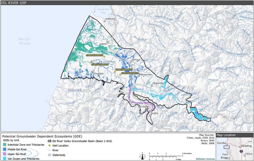
Technical Appendix                                                                          Eel River Valley Basin Beneficial Uses

                                                    Table of Contents
1    INTRODUCTION................................................................................................................... 1

     1.1         Groundwater Basin Setting .......................................................................................... 1
     1.2         Hydrology .................................................................................................................... 3

2    BASIN PLAN AND BENEFICIAL USES OF WATER ..................................................... 4

3    ASSESSMENT ........................................................................................................................ 8

     3.1       Groundwater Dependent Ecosystem Units .................................................................. 8
     3.2       Beneficial Uses Conditions ........................................................................................ 10
           3.2.1 COLD. ................................................................................................................. 10
           3.2.2 WILD.. ................................................................................................................ 18
           3.2.3 RARE …………………………………………………………………………...18
           3.2.4 SPWN …………………………………………………………………………...24
           3.2.5 EST………………….. ........................................................................................ 25
           3.2.6 MIGR.. ................................................................................................................ 25
           3.2.7 REC-1. ................................................................................................................. 27
           3.2.8 REC-2. ................................................................................................................. 28

4    REFERENCES ...................................................................................................................... 29

Tables
Table 1.       Beneficial uses in the Eel River Valley Basin .............................................................. 7
Table 2.       GDE unit acreages in the ERVB ................................................................................... 8
Table 3.       Attributes supported by beneficial uses in the ERVB ................................................. 10
Table 4.       Tributary instream habitat data collected by CDFW during instream habitat
               inventories within the GDE units ................................................................................ 15
Table 5.       Mainstem Eel and Van Duzen rivers’ water temperatures for the warmest week of the
               summer, 1998 ............................................................................................................. 16
Table 6.       2019 Maximum weekly average water temperatures at selected site within tributaries
               that flow into the Upper Eel River and Van Duzen River GDE units ........................ 16
Table 7.       Cobble embeddedness ratings for fish bearing tributaries to the ERVB .................... 25
Table 8.       Fish migration timing and potential for groundwater management effects................. 27

Figures
Figure 1. Eel River Valley Groundwater Basin. ........................................................................... 2
Figure 2. GDE Units in the Eel River Valley Groundwater Basin. .............................................. 9
Figure 3. Pool, riffle, and flatwater percentages in the Middle Eel River GDE Unit
          2005–2020. .................................................................................................................. 11
Figure 4. Pool, riffle, and flatwater percentages in the Van Duzen River GDE Unit
          2005–2020. .................................................................................................................. 12
Figure 5. Preferred instream habitat area for Chinook salmon holding and spawning, Age 2+
          steelhead rearing, alcoves, and juvenile coho salmon rearing from 2005–2020 in
          the Middle Eel River GDE Unit. ................................................................................. 13

September 2021                                                                                                       Stillwater Sciences
                                                                      ii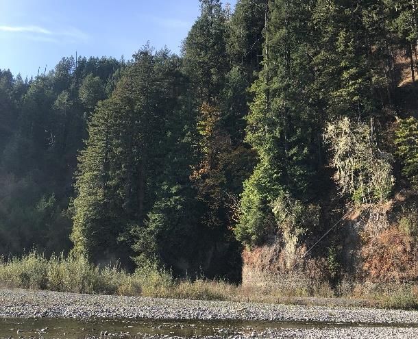
Technical Appendix                                                                Eel River Valley Basin Beneficial Uses

Figure 6. Preferred instream habitat area for salmonid spawning, Age 2+ steelhead rearing,
          alcoves, juvenile coho salmon rearing, and adult holding 2006–2020 in the Van
          Duzen River GDE Unit. .............................................................................................. 14
Figure 7. Lower Eel River water temperatures at several locations in the Middle Eel and
          Upper Eel GDE units and locations farther upstream indicating stressful conditions
          for adult Chinook salmon at the time of first entry until mid-September; red arrows
          indicate underwater survey dates by the ERRP ........................................................... 17
Figure 8. Aquatic species distribution in the Eel River Groundwater Basin. ............................. 19
Figure 9. Riffle crest depths at selected riffle locations and flows, 2010–2020. ........................ 26

September 2021                                                                                          Stillwater Sciences
                                                               iii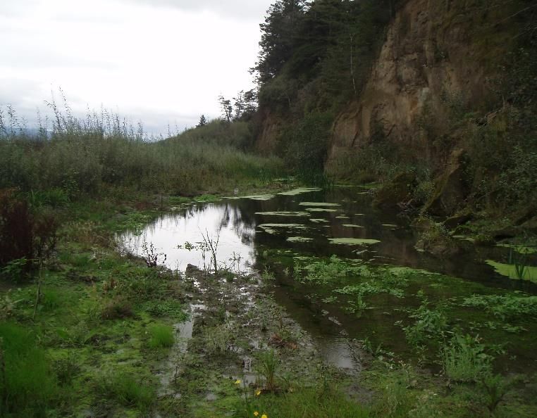
Technical Appendix Eel River Valley Basin Beneficial Uses
1 INTRODUCTION
This Technical Appendix for the Eel River Valley Groundwater Sustainability Plan (GSP)
addresses the baseline conditions for surface water beneficial uses in the Eel River Valley Basin
(ERVB) (Basin 1-010). The Sustainable Groundwater Management Act (SGMA) requires
Groundwater Sustainability Agencies (GSAs) to consider the interests of all beneficial uses and
users of groundwater, including surface water users if there is a hydrologic connection between
surface and groundwater bodies (Water Code 10723.2). Furthermore, sustainable management
criteria developed by the Humboldt County Groundwater Sustainability Agency (Humboldt
County GSA) should avoid significant and unreasonable effects on beneficial uses of
groundwater and interconnected surface water in the ERVB. Beneficial uses of surface water are
listed in the Water Quality Control Plan (Basin Plan) for the North Coast Region (North Coast
Regional Water Quality Control Board [NCRWQCB] 2018).
The information contained within this technical memorandum—when used in combination with
the mapped groundwater dependent ecosystems (GDEs) (Stillwater Sciences 2021a), surface and
groundwater hydrology, and hydraulic modeling—can be used to inform the development of
sustainable management criteria for the ERVB. Because this memorandum and the groundwater
model were developed concurrently, they will be synthesized in the final GSP, where the
sustainable management criteria will be presented.
1.1 Groundwater Basin Setting
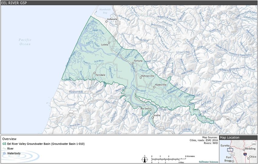
The ERVB is a coastal basin in western Humboldt County, located at the downstream end of the
Eel River watershed and extending from the Pacific Ocean upstream through the lower reaches of
the Eel and Van Duzen river valleys (Figure 1). The valley floor comprises the majority of the
basin’s 72,957-acre surface area and ranges in elevation from 0 to 30 feet above sea level (ft asl).
The foothills that mark the basin’s inland perimeter reach elevations of up to 300 ft asl.
September 2021 Stillwater Sciences
1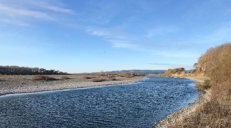
Technical Appendix                      Eel River Beneficial Uses Conditions

Figure 1. Eel River Valley Basin.

September 2021                                          Stillwater Sciences
                                    2
Technical Appendix                                             Eel River Valley Basin Beneficial Uses

1.2        Hydrology
The Eel River is the third largest watershed in California, draining 3,684 square miles (California
Department of Fish & Wildlife [CDFW] 2014). The mainstem Eel River is approximately 197
miles long, with headwaters in Mendocino County, 10 miles north of Lake Pillsbury. Upstream of
the basin, the river is dammed at the Scott and Cape Horn dams, forming Lake Pillsbury and Van
Arsdale Reservoir, respectively. Between 2010 and 2019, average annual discharge in the Lower
Eel River near Scotia (U.S. Geological Survey [USGS] gage 11477000) ranged between 1,619
and 12,150 cubic feet per second (cfs); monthly average discharge ranged between 32 cfs (August
2014) and 54,201 cfs (February 2017) (USGS 2019). The Van Duzen River drains into the Eel
River about 14 miles upstream of the Pacific Ocean. Other major tributaries include Yager Creek,
which joins the Van Duzen below the Town of Carlotta.

The Eel River experiences very high levels of sedimentation (CDFW 2014). Sedimentation has
significantly impacted the Salt River, a remnant channel of the Eel River; many of the Salt
River’s low-gradient tributaries have filled with sediment and do not convey significant surface
flow. As of 2019, restoration efforts by the Humboldt County Resource Conservation District
(HCRCD) have opened portions of the Salt River to tidal inundation and partial freshwater inputs
(HCRCD 2021).

The primary aquifers in the basin are the Carlotta formation in the Upper Wildcat group and the
sequence of overlying unconsolidated alluvial deposits. Groundwater in the Carlotta formation is
typically confined or semi-confined by silt and clay interbeds. The Carlotta formation is typically
over 1,500 ft thick and may be up to 4,000 ft thick locally, but the maximum productive depth is
not well defined. Wells tapping the Carlotta formation are between 200 and 400 ft deep; artesian
conditions occur in wells near the foothills (GHD 2021a). The alluvial aquifer is up to 200 ft thick
and unconfined, with high conductivity. Most wells in the alluvial aquifer are about 70 ft deep.
Hydrologic connectivity between the alluvial aquifer and the Carlotta formation is not well
understood, but there is likely some connection between the two in the central part of the basin
(GHD 2021a). The extent of interconnected surface water is currently being mapped using a
combination of historical field observations and a groundwater hydrology model also in
development.

The alluvial aquifer is the primary water source for most agricultural wells (GHD 2021a).
Irrigation is the primary groundwater use sector. In 2016, the Humboldt County Resource
Conservation District (HCRCD) estimated that annual groundwater extraction from the basin for
irrigation ranges from 10,265 acre-ft to 16,680 acre-ft. This estimate is currently being updated
(Humboldt County et al, 2021). Average annual extraction for municipal, cannabis cultivation,
and other uses is approximately 1,733 acre-ft, 98 acre-ft, and 414 acre-ft, respectively (GHD
2021b).

Groundwater in the basin flows east to west, down the Eel and Van Duzen river valleys to the
coast. Groundwater discharge occurs at springs and seeps in the upland areas and by subsurface
flow to the tidal estuary (GHD 2021b). Since the completion of a 1975 USGS study, there has
been no evidence to suggest that the location of freshwater-seawater transition zone is migrating
landward, except for modest salinity increases near the Salt River and Loleta (SHN 2021). Most
of the alluvial aquifer located north of the Eel River, adjacent to the tidally influenced reach of
the river, is naturally degraded by seawater (USGS 1978). South of Eel River, elevated chloride
concentrations (>100 mg/L) were detected in the alluvium along the coast where ground elevation
was less than 10 ft asl. Chloride concentration increased with depth at a given distance from the

September 2021                                                                   Stillwater Sciences
                                                 3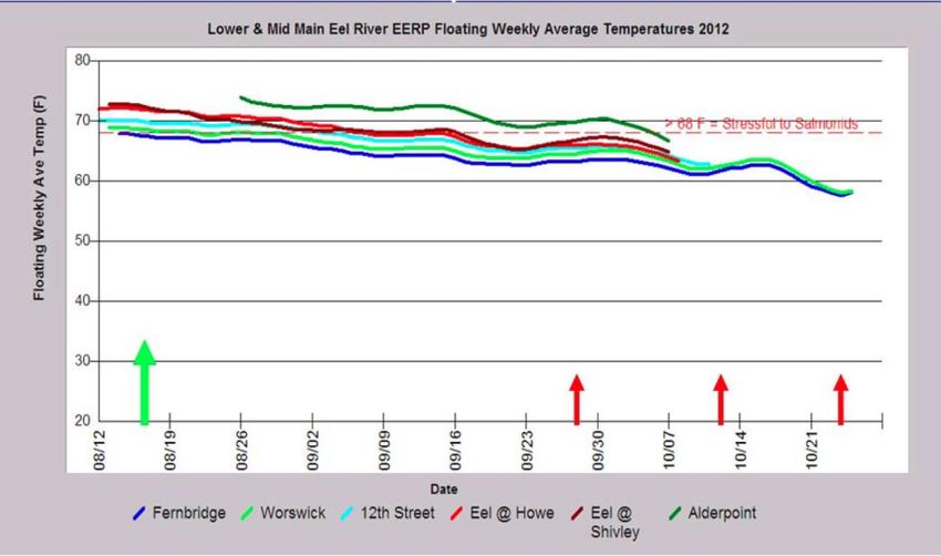
Technical Appendix                                               Eel River Valley Basin Beneficial Uses

coast. Substantial recharge to the groundwater system from the Eel River upstream of the tidally
influenced reach sustains a seaward hydraulic gradient that moderates seawater intrusion in the
area (USGS 1978). During the dry season, tidal cycles produce fluctuations in surface water
levels of as much as 1.5 ft, causing localized transitions between gaining and losing stream
conditions (SHN 2019).

Surface water systems are strongly connected to the shallow alluvial aquifer (SHN 2019).
Preliminary groundwater model river discharge results provided by GHD show gaining
conditions on the Van Duzen River upstream of Yager Creek. Downstream of Yager Creek,
losing conditions are more prevalent. For example, the Van Duzen goes dry most years in the
vicinity of Highway 101, a losing reach. Continuous coupled groundwater and surface water
monitoring initiated by Humboldt County in 2016 indicates that subsurface contributions from the
Van Duzen strongly influence surface-groundwater connections on the east bank of the Eel River
downstream of the Van Duzen confluence (SHN 2019). Due to the steep groundwater gradient
toward the Eel River from the east, gaining stream conditions are thought to occur year-round in
this reach, consistent with preliminary model results. Monitoring on the west bank of the Eel
River between the Van Duzen River confluence and Fortuna shows losing conditions near the
confluence, particularly during the dry season, transitioning to gaining conditions downstream
that typically occur during the wet season (SHN 2019). Preliminary model results indicate that a
slight gaining reach occurs downstream at Fortuna due to subsurface contributions from Strongs
Creek and Rohner Creek. Gaining conditions also occur at Fernbridge and along much of the Salt
River. Model results show slight losing conditions on some tributaries of the Van Duzen River
(Fox Creek) and Salt River (Williams, Francis, and Reas creeks).

The shallow aquifer is hydraulically connected with the ocean along approximately 10 miles of
coastline. In the Eel River, tidal influence extends upstream of Fernbridge, approximately 12
miles inland from the river mouth (SHN 2021).

2        BASIN PLAN AND BENEFICIAL USES OF WATER
The Basin Plan for the North Coast Region (NCRWQCB 2018) defines beneficial uses as “the
waters of the state that may be protected against water quality degradation,” which “include, but
are not necessarily limited to, domestic, municipal, agricultural, and industrial supply; power
generation; recreation; aesthetic enjoyment; navigation; and preservation and enhancement of
fish, wildlife, and other aquatic resources or preserves.” The ERVB is contained within the Lower
Eel River and Van Duzen River hydrologic areas (HA) delineated by the NCRWQCB (2018).
Because the shallow aquifer and surface water are interconnected in parts of the ERVB (SHN
2019), surface water beneficial uses could be impacted by groundwater management. The extent
and degree to which groundwater management may affect surface water flows will be explored
once the groundwater model is finalized. This will therefore be addressed in the final GSP.

The Basin Plan (NCRWQCB 2018) designates multiple beneficial uses for surface and
groundwater within the ERVB. The HA share many of the same beneficial uses (Table 1), which
include:
    • MUN (Municipal and Domestic Supply) – Uses of water for community, military, or
      individual water supply systems, including, but not limited to, drinking water supply
    • AGR (Agricultural Supply) – Uses of water for farming, horticulture, or ranching,
      including, but not limited to, irrigation, stock watering, or support of vegetation for range
      grazing

September 2021                                                                     Stillwater Sciences
                                                  4
Technical Appendix Eel River Valley Basin Beneficial Uses
• IND (Industrial Service Supply) – Uses of water for industrial activities that do not depend
primarily on water quality, including, but not limited to, mining, cooling water supply,
hydraulic conveyance, gravel washing, fire protection, or oil well repressurization
• GWR (Groundwater Recharge) – Uses of water for natural or artificial recharge of
groundwater for purposes of future extraction, maintenance of water quality, or halting of
saltwater intrusion into freshwater aquifers
• FRSH (Freshwater Replenishment) – Uses of water for natural or artificial maintenance of
surface water quantity or quality (e.g., salinity)
• NAV (Navigation) – Uses of water for shipping, travel, or other transportation by private,
military, or commercial vessels
• REC-1 (Water Contact Recreation) – Uses of water for recreational activities involving
body contact with water, where ingestion of water is reasonably possible, including, but
not limited to, swimming, wading, water skiing, skin and scuba diving, surfing, whitewater
activities, fishing, or use of natural hot springs
• REC-2 (Non-Contact Water Recreation) – Uses of water for recreational activities
involving proximity to water, but not normally involving body contact with water, where
ingestion of water is reasonably possible, including, but not limited to, picnicking,
sunbathing, hiking, beachcombing, camping, boating, tidepool and marine life study,
hunting, sightseeing, or aesthetic enjoyment in conjunction with the above activities
• COMM (Commercial and Sport Fishing) – Uses of water for commercial and recreational
(sport) collection of fish, shellfish, or other aquatic organisms, including, but not limited
to, uses involving organisms intended for human consumption or bait purposes
• COLD (Cold Freshwater Habitat) – Uses of water that support cold water ecosystems, such
as preservation or enhancement of aquatic habitats, vegetation, fish, or wildlife, including
invertebrates
• WILD (Wildlife Habitat) – Uses of water that support terrestrial ecosystems, including, but
not limited to, preservation and enhancement of terrestrial habitats, vegetation, wildlife
(e.g., mammals, birds, reptiles, amphibians, invertebrates), or wildlife water and food
sources
• RARE (Rare, Threatened, or Endangered Species) – Uses of water that support habitats
necessary, at least in part, for the survival and successful maintenance of plant or animal
species established under State or federal law as rare, threatened, or endangered
• MIGR (Migration of Aquatic Organisms) – Uses of water that support habitats necessary
for migration or other temporary activities by aquatic organisms, such as anadromous fish
• SPWN (Spawning, Reproduction, and/or Early Development) – Uses of water that support
high-quality aquatic habitats suitable for reproduction and early development of fish
• CUL (Native American Culture) – Uses of water that support the cultural and/or traditional
rights of indigenous people, such as subsistence fishing and shellfish gathering, basket
weaving and jewelry material collection, navigation to traditional ceremonial locations, and
ceremonial uses
September 2021 Stillwater Sciences
5Technical Appendix Eel River Valley Basin Beneficial Uses
Additional beneficial uses for the Lower Eel River HA comprise:
• SHELL (Shellfish Harvesting) – Uses of water that support habitats suitable for the
collection of filter-feeding shellfish (e.g., clams, oysters, and mussels) for human
consumption, commercial, or sports purposes
• EST (Estuarine Habitat) – Uses of water that support estuarine ecosystems, including, but
not limited to, preservation or enhancement of estuarine habitats, vegetation, fish, shellfish,
or wildlife (e.g., estuarine mammals, waterfowl, shorebirds)
Potential beneficial uses in the Lower Eel River HA include:
• PRO (Industrial Process Supply) – Uses of water for industrial activities that depend
primarily on water quality
• POW (Hydropower Generation) – Uses of water for hydropower generation
• MAR (Marine Habitat) – Uses of water that support marine ecosystems, including, but not
limited to, preservation or enhancement of marine habitats and vegetation such as kelp,
fish, shellfish, or wildlife (e.g., marine mammals, shorebirds)
• AQUA (Aquaculture) – Uses of water for aquaculture or mariculture operations, including,
but not limited to, propagation, cultivation, maintenance, or harvesting of aquatic plants
and animals for human consumption or bait purposes
Additional beneficial uses for the Van Duzen River HA include:
• WARM (Warm Freshwater Habitat) – Uses of water that support warm water ecosystems,
such as preservation or enhancement of aquatic habitats, vegetation, fish, or wildlife,
including invertebrates
Additional potential beneficial uses for the Van Duzen River HA comprise PRO, POW, and
AQUA.
Beneficial uses the NCRWQCB (2018) did not designate in the ERVB include:
• ASBS (Preservation of Areas of Special Biological Significance [ASBS]) – Includes
marine life refuges, ecological reserves, and designated ASBS, such as areas where kelp
propagation and maintenance are features of the marine environment, requiring special
protection
• SAL (Inland Saline Water Habitat) – Uses of water that support inland saline water
ecosystems, such as preservation or enhancement of aquatic saline habitats, vegetation,
fish, or wildlife, including invertebrates
• FLD (Flood Peak Attenuation/Flood Water Storage) – Uses of riparian wetlands in flood
plain areas and other wetlands that receive natural surface drainage and buffer its passage
to receiving waters
• WET (Wetland Habitat) – Uses of water that support natural and man-made wetland
ecosystems, including, but not limited to, preservation or enhancement of unique wetland
functions, vegetation, fish, shellfish, invertebrates, insects, and wildlife habitat
• WQE (Water Quality Enhancement) – Uses of waters, including wetlands and other
waterbodies, that support natural enhancement or improvement of water quality in or
downstream of a waterbody, such as erosion control, filtration and purification of naturally
occurring water pollutants, streambank stabilization, maintenance of channel integrity, and
siltation control
September 2021 Stillwater Sciences
6Technical Appendix Eel River Valley Basin Beneficial Uses
Table 1. Beneficial uses in the Eel River Valley Basin (NCRWQCB 2018)
Hydrologic MUN AGR IND GWR FRSH NAV
REC REC
COMM COLD WILD RARE MIGR SPWN CUL SHELL EST PRO POW MAR AQUA
WAR
area 1 2 M
Lower Eel X X X X X X X X X X X X X X X X X P P P P
Van Duzen X X X X X X X X X X X X X X X P X P X
X = Designated beneficial use
P = Potential beneficial use
September 2021 Stillwater Sciences
7Technical Appendix Eel River Valley Basin Beneficial Uses
3 ASSESSMENT
No studies of minimum instream flow requirements within the ERVB were found for any of the
beneficial uses identified above or discussed below. However, there has been an ongoing long-
term (2005–2020) instream habitat monitoring program within the ERVB conducted by the local
instream gravel miners in compliance with their local, state, and federal permits. This monitoring
program collected data within the lower Eel River (mouth of Van Duzen River to Fernbridge;
approximately 6.7 river miles) and at selected sites in the Van Duzen River downstream of
Carlotta (approximately 3.9 river miles). Data collected include pool, riffle, and flatwater ratios;
preferred holding, spawning, and rearing habitats for adult and juvenile salmonid; and pool and
riffle depths (Stillwater Sciences 2020b). Summary results from the monitoring program are
reported below in Section 3.2.
3.1 Groundwater Dependent Ecosystem Units
SGMA defines GDEs as “ecological communities of species that depend on groundwater
emerging from aquifers or on groundwater occurring near the ground surface” (23 CCR §
351(m)). As described in The Nature Conservancy’s guidance for GDE analysis (Rohde et al.
2018), a GDE’s dependence on groundwater refers to reliance of GDE species and/or ecological
communities on groundwater for all or a portion of their water needs. Stillwater Sciences (2021a)
identified four GDE Units within the ERVB based on hydrologic characteristics within the basin
(Table 2, Figure 2). These are:
• Intertidal Zone and Tributaries: Intertidal reach downstream of Fernbridge
• Middle Eel River: Fernbridge to Eel/Van Duzen rivers’ confluence
• Upper Eel River: Eel/Van Duzen rivers’ confluence to Scotia
• Van Duzen River and Tributaries: Lower Van Duzen River
Table 2. GDE unit acreages in the ERVB
GDE unit Area (acres)
Intertidal Zone and Tributaries 5,981
Middle Eel River 3,809
Upper Eel River 1,136
Van Duzen River and Tributaries 2,878
Total 13,804
1 Totals may not appear to sum exactly due to rounding error.
These GDE units provide a spatial framework for the beneficial uses discussion below.
September 2021 Stillwater Sciences
8Technical Appendix Eel River Valley Basin Beneficial Uses
Figure 2. GDE units in the ERVB
September 2021 Stillwater Sciences
9Technical Appendix Eel River Valley Basin Beneficial Uses
3.2 Beneficial Uses Conditions
The Basin Plan (NCRWQCB 2018) identifies the surface waters of the ERVB as having a variety
of beneficial uses pertaining to fish, wildlife, and GDEs. Beneficial uses within the ERVB linked
to GDEs include COLD, WILD, RARE, MIGR, SPWN, and EST. Each of these contain
biological attributes, some unique and others common, which illustrate the linkages between
beneficial uses (Table 3).
Table 3. Attributes supported by beneficial uses in the ERVB
Attributes supported by beneficial uses
Beneficial
uses Aquatic Terrestrial Food Water Estuarine
Vegetation Fish Wildlife Migration Shellfish
habitat habitat sources sources habitat
COLD x x x x
MIGR x x x
RARE x x x x x x
WILD x x x x x
SPWN x x
EST x x x x x
The ERVB also supports beneficial uses REC-1 and REC-2. The recreational attributes supported
by REC-1 include swimming, wading, skin and scuba diving, and fishing. The recreational
attributes supported by REC-2 include picnicking, sunbathing, hiking, boating, hunting,
sightseeing, and aesthetic enjoyment.
3.2.1 COLD
The Cold Freshwater Habitat (COLD) beneficial uses support cold water ecosystems for the
preservation or enhancement of aquatic habitats, vegetation, fish, or wildlife, including
invertebrates. The GDE units within the ERVB are cold water systems and support habitat for a
variety of cold-water-dependent species, including, but not limited to, Chinook salmon
(Oncorhynchus tshawytscha), coho salmon (Oncorhynchus kisutch), steelhead (Oncorhynchus
mykiss), longfin smelt (Spirinchus thaleichthys), green sturgeon (Acipenser medirostris), and
Pacific lamprey (Entosphenus tridentatus), which are described below in the RARE section.
Several other fish and wildlife species also occupy the groundwater basin and will be described in
other beneficial uses sections below.
COLD beneficial uses are a function of available habitat, including the extent of pools, riffles,
and flatwater within a given reach. This section therefore summarizes available habitat to assess
whether there are any temporal trends in habitat distribution and to help ascertain whether current
groundwater and interconnected surface water management could be affecting habitat
availability.
3.2.1.1 Pool, riffle, and flatwaters
The relative proportions of pool, riffle, and flatwater habitat in the lower Eel River Valley
between the mouth of the Van Duzen River and Fernbridge have varied between 2005 and 2020
in response to winter flow patterns, changes in thalweg locations, sediment depositional patterns,
and presence or absence of significant secondary channels. In general, the pool and flatwater
September 2021 Stillwater Sciences
10Technical Appendix Eel River Valley Basin Beneficial Uses
percentages have been inversely proportional while the riffles have varied by about five percent
(Figure 3).
Figure 3. Pool, riffle, and flatwater percentages in the Middle Eel River GDE Unit 2005–2020
(Stillwater Sciences 2021b)
Similarly, in the Middle Eel River GDE Unit, the pool and flatwater percentages in the Van
Duzen River and Tributaries GDE Unit have been generally inversely proportional while the
riffles have varied by about 10 percent (Figure 4). However, some locations in the Van Duzen
River go dry or have extremely low flows during the summer period, which also affect the pool,
riffle, and flatwater percentages. The jump in the pool percentage during 2013 may have been due
in part to the inclusion of an additional area (County of Humboldt’s PALCO Bar), which contains
a higher percentage of pools than the more downstream alluvial flats area between Carlotta and
the mouth of the Van Duzen River.
September 2021 Stillwater Sciences
11Technical Appendix Eel River Valley Basin Beneficial Uses
Figure 4. Pool, riffle, and flatwater percentages in the Van Duzen River and Tributaries GDE
Unit 2005–2020 (Stillwater Sciences 2021b)
3.2.1.2 Instream habitat area
The preferred instream habitat areas for salmonid spawning, steelhead (age 2+) rearing, alcoves,
juvenile coho salmon rearing, and adult holding in the Middle Eel River GDE Unit, from the
mouth of the Van Duzen River to Fernbridge, and the Van Duzen River and Tributaries GDE
Unit, from the confluence of the Eel River to Carlotta, have been mapped on a near-annual basis
from 2005–2020 (Stillwater Sciences 2021b). Preferred holding habitat for adult Chinook salmon
generally consists of pools with water velocities ranging from 0.5–1.5 ft per second (fps) and
depths greater than 3 ft. In both reaches, spawning habitat typically occurs in pool tailouts, riffles,
or runs where the water is 0.75–2.5 ft deep, flowing at 1–3 fps, over a small gravel to small
cobble substrate. Juvenile coho salmon generally utilize the margins of pool and flatwater habitat
units with relatively slow (0.5–1.5 fps) water velocities that contain overhanging and submerged
vegetation and cool water seeps. Coho salmon have also been observed in alcoves containing cool
water during the late summer and early fall. Age 2+ steelhead prefer to reside in run habitats
where the water velocity is between 0.75 and 1.5 fps near the bottom, in depths of 1–3 ft, and
have a cobble/small boulder substrate. Age 2+ steelhead also prefer head-of-pool habitats below
the entry point of riffles. Alcoves are off-channel habitats located on the downstream end of
gravel bars and may provide velocity refuge for juvenile salmonids during high flows, as well as
potential thermal refuge during the summer season.
Due to the nearly annual changes to natural river thalweg, monitoring reach lengths during these
years have varied considerably, which required normalizing the instream habitat metrics to square
ft of habitat per linear ft of stream length. Adult holding habitat for all three salmonids is the most
common habitat mapped within the Middle Eel River GDE Unit monitoring reach (Figure 5).
Juvenile coho salmon habitat is non-existent due to the lack of pools formed by woody debris and
warm water temperatures. Spawning habitat for all three salmonids is relatively scarce due to the
relatively small substrate size and significant bedload transport. Alcoves are also relatively rare in
September 2021 Stillwater Sciences
12Technical Appendix Eel River Valley Basin Beneficial Uses
the Middle Eel GDE Unit, particularly since 2013. The presence of alcoves is a function of gravel
scour that occurs during high flow events in secondary channels located along the back side of
gravel bars. The upstream ends of alcoves are generally at higher elevations than the downstream
areas that may stay watered the entire year.
Figure 5. Preferred instream habitat area for Chinook salmon holding and spawning, age 2+
steelhead rearing, alcoves, and juvenile coho salmon rearing from 2005 to 2020 in
the Middle Eel River GDE Unit (Stillwater Sciences 2021b)
The preferred instream habitat areas for salmonid spawning, age 2+ steelhead rearing, alcoves,
juvenile coho salmon rearing, and adult holding in the Van Duzen River monitoring reaches have
also varied considerably on an annual basis (Figure 6). In general, water years with high sustained
winter flows have resulted in increases in pools and associated holding and age 2+ steelhead
habitat. These high flows have also mobilized and sorted instream sediment deposits, which
rejuvenated spawning gravel. Juvenile coho salmon habitat has been limited by a relative lack of
woody debris and high water temperatures. Because the width of the Van Duzen River is so much
narrower than the Eel River, the habitat areas are smaller per unit length of channel.
September 2021 Stillwater Sciences
13Technical Appendix Eel River Valley Basin Beneficial Uses
Figure 6. Preferred instream habitat area for salmonid spawning, age 2+ steelhead rearing,
alcoves, juvenile coho salmon rearing, and adult holding 2006—2020 in the Van Duzen
River and Tributaries GDE Unit (Stillwater Sciences 2021b)
Tributaries to the Middle Eel, Upper Eel, and Van Duzen River and Tributaries GDE units within
the ERVB contain cold water habitat and support anadromous fish and other aquatic biota.
CDFW and its predecessor, California Department of Fish and Game (CDFG), periodically
conducted instream habitat inventories within the watercourses that are tributary to the GDE units
using the Flosi et al. (1998) protocol. Instream habitat data collected as part of this protocol
included, but was not limited to, flow (cfs), pool, riffle, flatwater lengths, and water temperatures.
Selected instream habitat data are presented below for several tributaries that flow into the GDE
units (Table 4). Although the CDFW/CDFG-inventoried streams flow into the GDE units, most
of their lengths extend into the steeper areas outside GDE boundaries. These steeper reaches are
not likely to be affected by floodplain groundwater management due to generally being within
forested landscapes and due to the lack of wells.
September 2021 Stillwater Sciences
14Technical Appendix Eel River Valley Basin Beneficial Uses
Table 4. Tributary instream habitat data collected by CDFW during instream habitat inventories within the GDE units
Habitat attributes
Watercourse GDE unit Survey dates Flow Flatwater Temperature
Pool % Riffle %
(cfs) % Celsius (°C)
Francis Creek Intertidal June 2–20, 2003 1.1 47 34 19 12–16
1
Barber Creek Middle Eel July 22–28, 2008 - 47 38 7 12–13
Howe Creek Upper Eel August 13–18, 1998 0.5 6 66 28 14–19
Howe Creek Upper Eel June 21–29, 2017 4.8 17 48 35 12–18
September 15, October 18–20 and
Price Creek Upper Eel - 12 57 30 7–15
25–26, and November 2–3,1999
Price Creek Upper Eel June 20–July 17, 2017 2 16 23 60 13–18
Oil Creek Upper Eel June 25–29, 2002 - 42 28 31 13–16
Monument Creek Upper Eel July 6–7, 2010 1.9 33 47 20 12–14
2
Hely Creek Van Duzen River June 5–19, 2006 2.1 23 37 37 12–14
Hely Creek Van Duzen River September 25–October 4, 2017 1.4 22 28 37 10–13
¹ Additional Level II Habitat: 1% culvert, 1% dry
² Additional Level II Habitat: 3% dry
September 2021 Stillwater Sciences
15Technical Appendix Eel River Valley Basin Beneficial Uses
3.2.1.3 Water temperatures
Sufficiently cool water temperatures is a habitat requirement for salmonids. Water temperatures
above 20 °C stress Chinook salmon and steelhead; those above 25°C can be lethal. Coho salmon
have lower water temperature tolerances and tend not to be present in waters with maximum
temperatures exceeding 18°C unless there are cool water refuges available. Water temperatures
tend to be higher in the summer when air temperatures are highest, and lowest during the winter
due to lower air temperatures and greater inflows. Water temperatures in wide mainstem river
reaches tend to be warmer than smaller tributary streams during the summer due to sunlight
heating the substrate, lack of shade canopy, and relatively high air temperatures. Water
temperatures are typically lower in tributaries outside of the ERVB where more confined
channels and increased vegetative shading are present. Groundwater management may affect
stream temperatures in reaches with interconnected surface water by increasing the relative flux
of cooler groundwater to warm streams, but the degree to which this occurs in the ERVB has not
been investigated.
Water temperature monitoring was conducted in 1998 within the Eel River from the mouth of the
Van Duzen River to Fernbridge (Table 5). Monitoring was also conducted at three locations in the
Van Duzen River between Carlotta and Highway 101. The data analysis included calculating the
average daily and average maximum water temperatures for the warmest week. The data showed
that water temperatures within the lower Eel and Van Duzen rivers exceed stressful levels (>18–
20°C) for anadromous salmonids, as well as that water temperatures cooled slightly the closer the
river was to the coast and zone of marine influence.
Table 5. Mainstem Eel and Van Duzen rivers’ water temperatures for the warmest week of the
summer, 1998 (Halligan 1998, unpub. data)
Average
Average
Location Lat/long (deg min sec) GDE Unit maximum
daily (°C)
(°C)
Eel/VD river
40º32’17”N, 124º09’15”W Middle Eel 22.2 24.1
confluence
Hauck/Hansen 40º32’52”N, 124º09’13”W Middle Eel 21.3 23.1
Drake 40º36’10”N, 124º10’30”W Middle Eel 21.7 22.8
Worswick 40º36’20”N, 124º11’20”W Middle Eel 21.3 22.3
Bess 40º31’30”N, 124º03’10”W Van Duzen River 20.8 24.1
Noble 40º31’25”N, 124º05’40”W Van Duzen River 20.7 23.7
Leland 40º32’07”N, 124º08’20”W Van Duzen River 20.4 23.1
Fernbridge 40º36’57”N, 124º12’05”W Intertidal 21.4 22.7
As part of their Habitat Conservation Plan monitoring program, Humboldt Redwood Company
(HRC) has been collecting water temperature data in selected tributary watercourses to the Upper
Eel River and Van Duzen River GDE units. HRC analyzes their data and reports the temperature
information as a maximum weekly average temperature (MWAT; Table 6). Water temperatures
for the watercourses below do not exceed the 16.8°C threshold for coho salmon.
Table 6. 2019 Maximum weekly average water temperatures at selected site within tributaries
that flow into the Upper Eel River and Van Duzen River GDE units (HRC 2020)
September 2021 Stillwater Sciences
16Technical Appendix Eel River Valley Basin Beneficial Uses
ATM site/number GDE unit Year MWAT (°C)
Monument 106 Upper Eel 2019 16.1
Atwell/242 Upper Eel 2019 16.7
Hely/112 Van Duzen River 2019 15.2
Cummings/108 Van Duzen River 2019 15.7
The Eel River Recovery Project (ERRP) conducted water temperature monitoring in 2012 and
2013 on the lower Eel River to check for suitability for holding adult Chinook salmon (ERRP
2013, 2014). Water temperatures in the lower Eel River were coolest at Fernbridge and warmed
progressively upstream, with a substantial jump between the 12th Street pool (Fortuna) and Howe
Creek, upstream of the Van Duzen River. The floating weekly water temperatures of the lower
Eel River reaches accessible to Chinook salmon remained above stressful until the first week of
September in 2012 (Figure 7). However, in 2013, the river was significantly warmer (3–5°F), but
an early rain reduced water temperatures to more suitable ranges by the second week of
September (ERRP 2014). Figure 7 also shows that water temperatures decreased in a downstream
direction as the river entered the zone of coastal influence.
Figure 7. Lower Eel River water temperatures at several locations in the Middle Eel and Upper
Eel GDE units, and in locations farther upstream (Shivley and Alderpoint), indicating
stressful conditions for adult Chinook salmon at the time of first entry (green arrow)
until mid-September; red arrows indicate underwater survey dates by the ERRP (ERRP
2013); salmonids experience stress at temperatures greater than 68°F (20°C)
Water temperatures in the Eel River Estuary vary depending on the season, location, channel
depth, heights of tides, and river discharge. Seasonal water temperatures in the Intertidal GDE
Unit can range from ambient sea water (~50–55°F) to ambient river water (~38–75°F) (Puckett
1977 and Cannata 1994–95 field notes, as cited in CDFG 2010). During the winter, the coldest
water is usually found on the surface when river flows exposed to cold air flow into the estuary.
Conversely in summer as river flows decline, the coldest water is delivered by ocean tides. Tides
push a wedge of cold seawater up the main estuarine channel that mixes with the warmer fresh or
brackish water of the middle and upper estuary zones (CDFG 2010).
September 2021 Stillwater Sciences
17Technical Appendix Eel River Valley Basin Beneficial Uses
In summary, water temperatures within the Middle Eel, Upper Eel, and Van Duzen River GDE
units are generally too warm during the summer to support adult salmonids. Nearly all juvenile
Chinook salmon would have migrated to the estuary and ocean prior to the onset of warmer water
temperatures. In addition, water temperatures are too warm to support juvenile coho salmon and
are stressful for juvenile steelhead. Water temperatures in the Intertidal Zone and Tributaries
GDE Unit are moderated by the influences of the marine climate and tidal flux.
3.2.2 WILD
The wildlife habitat beneficial uses of water support (preserve and enhance) terrestrial ecosystems
and habitat for vegetation, wildlife (e.g., mammals, birds, reptiles, and amphibians), or wildlife
water and food sources. Several special-status wildlife species that are dependent on the GDEs in
the ERVB (see Section 3.2.3, below).
3.2.3 RARE
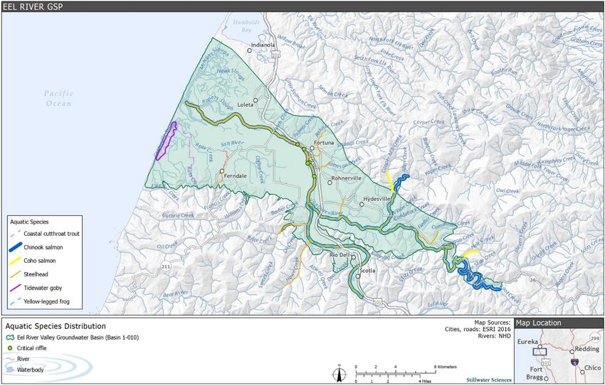
The ERVB supports several threatened, endangered, and species of special concern (Figure 8),
including fish, avian, amphibian, and reptile species. These species are briefly described below.
The following species summaries are adapted from the format contained in the Critical Species
LookBook (Rohde et al. 2019).
3.2.3.1 Fish
The following special-status fish species are present in the ERVB on a seasonal or permanent
basis.
California Coast ESU Chinook salmon (Oncorhynchus tshawytscha)
Status: Federally threatened
Reliance on groundwater: Direct. Chinook salmon are reliant on groundwater-fed rivers to
provide adequate water quality, temperature, and volume for upstream migration (in the fall
before rainfall elevates river flows), as well as for spawning and freshwater residency.
Habitat: Chinook salmon in the Eel River spend a relatively short time in freshwater as juveniles
before heading to estuaries or marine environments for the bulk of this phase of their lives. Adult
Chinook spawn in larger rivers and streams, where they require sufficient flows for migration and
largely sediment-free gravel for spawning. Juveniles need areas of refuge from high water
velocities during the wet season (e.g., in floodplains, backwaters). Water quality, including
temperature and dissolved oxygen, is important for juveniles living in estuaries.
Presence in the ERVB: Chinook salmon in the Eel River are primarily fall-run, although a small
number of spring-run fish do spawn and rear in the Middle Fork Eel River. They can be found in
the Eel River Valley during the fall adult upstream migration, early juvenile rearing, and spring
downstream smolt migration periods. Fall-run juvenile Chinook salmon generally do not rear in
freshwater during the summer and fall. Spring-run juveniles will rear for a year prior to migrating
downstream to the estuary and the ocean.
September 2021 Stillwater Sciences
18Technical Appendix Eel River Beneficial Uses Conditions
Figure 8. Aquatic species distribution in the ERVB; green circles indicate the general locations of critical riffles observed from 2006 to 2020
(Stillwater Sciences 2021b)
September 2021 Stillwater Sciences
19Technical Appendix Eel River Valley Basin Beneficial Uses
Southern Oregon Northern California Coast ESU Coho salmon (Oncorhynchus kisutch)
Status: Federally threatened; State threatened
Reliance on groundwater: Direct. Coho salmon are reliant on groundwater-fed rivers to provide
adequate water quality, temperature, and volume for upstream migration (in the fall before
rainfall elevates river flows), as well as for spawning and freshwater residency. Juvenile
salmonids generally require cold, clear, well-oxygenated water and adequate streamflow volume
during their time in freshwater. Adult salmon similarly require adequate water quality and volume
during their upstream migration. Juveniles can rear in mainstem rivers but are dependent on
locations that contain cold water tributary inflow, bank seeps, or subsurface flow upwelling.
Backwater alcoves with stratified water temperatures also provide habitat during the warm
summer months.
Habitat: Juveniles spend one year in freshwater prior to migrating to the estuary and ocean
during the spring. Juveniles require deep pools with cool water temperatures, slow water
velocities, and abundant instream cover during their rearing phase. Juveniles are associated with
native riparian vegetation that provides instream cover and food resources from insect drop.
Adults return to freshwater to spawn in the mid-fall to early winter of their third year. They
primarily spawn in tributaries to rivers but would spawn in larger rivers during drought years
when tributary flows are low.
Presence in the ERVB: The mainstem Eel (upstream of Fernbridge) and Van Duzen rivers are
used for migration only due to high summer water temperatures and general lack of habitat.
Juveniles have been found in Yager, Price, Williams, Francis, and Howe creeks.
Northern California Coast steelhead (Oncorhynchus mykiss)
Status: Federally threatened
Reliance on groundwater: Direct. Steelhead are reliant on rivers and streams that are likely
supported by groundwater. Juvenile steelhead generally require cold, clear, well oxygenated
water and adequate streamflow volume while residing in freshwater. Adult steelhead also require
adequate water quality and instream flows during their upstream and downstream migration,
which can be limited by streamflow depletion. However, adult steelhead typically conduct
upstream migrations in the winter and spring when streamflow are usually adequate. Cold
groundwater inputs can provide local areas of water temperature refugia in which rearing juvenile
steelhead are less susceptible to stress or mortality that can otherwise result from elevated water
temperatures during warm, dry months when stream flows are typically lowest.
Habitat: While steelhead are generally more adaptable to habitat extremes than either coho or
Chinook salmon, they nevertheless require cold water and complex instream habitat during their
freshwater juvenile residency, which generally lasts at least one year, including at least one dry
season. Juveniles outmigrate during the spring and early summer. A smaller outmigration occurs
in the late fall after water temperatures cool. Estuaries can provide important rearing habitat for
steelhead, with opportunities for rapid growth prior to entering the marine environment. For
upstream migration to spawning grounds, all adult salmonids require sufficient flow and suitably
cool water temperature, followed by streambeds with clean gravel, free of excessive fine
sediment deposition, in which to spawn. Some adult steelhead will survive to spawn a second or
third time; thus, adequate stream flows are required for post-spawn adult steelhead to migrate
downstream during spring.
Presence in the ERVB: Present in the mainstem Eel and Van Duzen rivers and tributaries. Small
numbers of juvenile steelhead have been observed rearing in the lower Eel and Van Duzen rivers
in alcoves and heads of pools (immediately downstream of riffles) during the summer and fall
months (D. Halligan, Stillwater Sciences, pers. comm. 2021).
Coastal cutthroat trout (Oncorhynchus clarkii clarkii)
Status: State species of concern
September 2021 Stillwater Sciences
20Technical Appendix Eel River Valley Basin Beneficial Uses
Reliance on groundwater: Direct. Coastal cutthroat trout are reliant on groundwater-fed rivers,
creeks, and sloughs to provide adequate water quality, temperature, and volume for upstream
migration. Juvenile salmonids generally require cold, clear, well-oxygenated water and adequate
streamflow volume during their time in fresh water.
Habitat: Prefer cool, clean water with ample cover and deep pools for holding in summer. They
prefer small, low gradient coastal streams and estuarine habitats, including lagoons. This species’
range overlaps with steelhead, but they tend to occupy smaller streams and can be found upstream
of barriers to anadromous salmonids. Spawning occurs in December to February, but could
extend further into the year. Juveniles rear in upstream reaches of streams for one year before
moving downstream to the estuary. These fish may move back and forth from estuarine to
freshwater environments.
Presence in the Eel River Valley groundwater basin: Present in the Intertidal GDE Unit within
the Salt River drainage. Found in Barber Creek (Middle Eel GDE Unit) in 1992 by CDFG. The
Van Duzen River is the southern-most range of this species.
Longfin smelt (Spirinchus thaleichthys)
Status: State threatened
Reliance on groundwater: Direct. These fish rely directly on groundwater discharge that
supports estuarine wetlands and sloughs used by the species for spawning, feeding, and rearing.
Longfin smelt have a low tolerance for warm waters.
Habitat: The smelt depend on a diverse range of habitats, such as offshore areas, coastal lagoons,
bays, estuaries, sloughs, and freshwater rivers and streams. Longfin smelt are euryhaline,
meaning they can tolerate a variety of salinity in their habitats, from completely freshwater to
marine, though spawning occurs preferentially in freshwater and areas of low salinity.
Presence in the ERVB: Longfin smelt are known to be present downstream of Fernbridge in the
Salt River area. The last recorded sighting upstream of Fernbridge was near the mouth of the Van
Duzen River in 1956 when several individuals were collected in a beach seine by the USFWS.
Green sturgeon (Acipenser medirostris)
Status: Southern DPS – federally threatened; Northern DPS – federal species of concern; State
species of special concern
Reliance on groundwater: Direct. This species relies on surface water flows that may be
supported by groundwater.
Habitat: This anadromous species spends most of its life at sea but returns to freshwater to
spawn. Young fish may remain in freshwater for up to two years. Adults spawn in fast, deep
water during the first half of the year. Post-spawn adults then move back down the river during
the fall and re-enter the ocean.
Presence in the ERVB: Green sturgeon are known to inhabit the lower Eel River and have been
frequently observed upstream of Fernbridge in the 12th Street pool adjacent to Riverwalk during
fall salmon surveys. Sturgeon have also been observed holding in the intertidal area downstream
of Fernbridge. Finally, Northern DPS sturgeon are presumed to spawn in the mainstem Upper Eel
River, based on observations at Fort Seward, approximately 80 miles upstream of the ERVB.
Spawning does not occur in the ERVB. The Southern DPS green sturgeon likely enter the Eel
River Estuary but are known to spawn only in the Sacramento River.
Tidewater goby (Eucyclogobius newberryi)
Status: Federal endangered
Reliance on groundwater: Direct. Tidewater gobies rely on surface waters in coastal areas that
are likely to be supported by groundwater discharge.
Habitat: These fish live in lagoons and estuaries with submerged and emergent aquatic
vegetation that can provide protection from predators and flooding. They also occupy locations
September 2021 Stillwater Sciences
21Technical Appendix Eel River Valley Basin Beneficial Uses
characterized by muted tidal flow in areas subject to tides, and can be found in backwater
marshes and freshwater tributaries to estuarine environments. Food sources comprise
macroinvertebrates (e.g., amphipods, aquatic insects).
Presence in the ERVB: Gobies are present in the sloughs of the Eel River Delta and the Salt
River restoration area. They are not present upstream of Fernbridge.
Pacific lamprey (Entosphenus tridentatus)
Status: California species of special concern
Reliance on groundwater: Direct. This species relies on surface water flows that may be
supported by groundwater.
Habitat: Spawning typically takes place from March through July depending on water
temperature and local conditions, such as seasonal flow regimes. Spawning occurs both in the
mainstem of medium-sized rivers and smaller tributaries and generally takes place in pool and run
tailouts and low gradient riffles. Both males and females build nests (redds), which are
approximately 1.25 square ft and constructed in gravel and cobble substrate. After about 30 days,
the eyeless larvae (ammocoetes) emerge from the gravel and begin drifting downstream.
Eventually they settle out of the water column and burrow into fine silt and sand substrate in low-
velocity, depositional areas such as pools, alcoves, and side channels where they may spend
between four and 10 years prior to migrating to the ocean, where they reside for approximately
18–40 months before returning to freshwater.
Presence in the ERVB: The ERVB is primarily used by adult lamprey as an upstream migration
corridor. However, lamprey ammocoetes may be found within the basin rearing in backwater
areas containing organic silty deposits or in the fine substrate between cobbles in the mainstem
river.
3.2.3.2 Birds
Bank swallow (Riparia riparia)
Status: Federal species of concern; State threatened
Reliance on groundwater: Indirect. This species relies on surface water that may be supported
by groundwater. Bank swallows’ diet consists of aquatic and terrestrial insects caught over nearby
water bodies and associated floodplain grasslands. On the Sacramento River, bank swallow
reproductive success appears to be positively associated with the previous winter’s streamflow,
and nesting burrows are more common in actively meandering reaches. This suggests that higher
flows in winter (prior to the initiation of nesting) improve nesting habitat and foraging conditions.
However, high stream flows or rapid drawdowns during their nesting season (April to June) may
increase the risk of nest failure due to inundation, bank slumping, or bank erosion.
Habitat: Bank swallows primarily live along bodies of water, such as rivers, streams, ocean
coasts, and reservoirs. This species is highly colonial and breeds in nesting burrows up to 3.3 ft
deep and constructed in near-vertical banks greater than 6.6 ft tall and generally more than 80 ft
long.
Presence in the ERVB: This species has established breeding colonies on the Lower Eel River,
upstream of Fernbridge, and reportedly on the Van Duzen River.
Yellow-billed cuckoo (Coccyzus americanus)
Status: Federal threatened; State endangered
Reliance on groundwater: Indirect. This species is reliant on groundwater-dependent riparian
vegetation for habitat.
Habitat: This riparian obligate species uses riparian evergreen and deciduous woodland and
southwestern North American wash/scrub complexes, selecting young stands of colonizing
vegetation or mature riparian forests for foraging and nesting. Cottonwood and willow trees are
September 2021 Stillwater Sciences
22Technical Appendix Eel River Valley Basin Beneficial Uses
an important foraging habitat in areas where the species has been studied in California. Cuckoos
appear to require large blocks (25 to 100 acres) of riparian habitat for nesting.
Presence in the ERVB: Yellow-billed cuckoos have been observed in the lower Eel River Valley
downstream of Fernbridge.
Snowy plover (Charadrius alexandrinus nivosus)
Status: Federally threatened
Reliance on groundwater: Indirect. Western snowy plovers primarily congregate on coastal
beaches but can nest near wetlands that may be supported by groundwater.
Habitat: These plovers breed above the high tide line on coastal beaches, sand spits, dune-backed
beaches, sparsely vegetated dunes, beaches at creek and river mouths, and salt pans at lagoons
and estuaries. They tend to nest near the shore, but also near freshwater or brackish wetlands
(e.g., river mouths, estuaries, and tidal marshes). They also utilize use dry river gravel bars that
are relatively close to the coast for breeding.
Presence in the ERVB: Confirmed breeding has been observed on gravel bars along the lower
Eel River between Fernbridge and the mouth of the Van Duzen River.
3.2.3.3 Amphibians
Foothill yellow-legged frog (Rana boylii)
Status: State species of special concern
Reliance on groundwater: Direct. This species relies on surface water flows that may be
supported by groundwater.
Habitat: Perennial streams or rivers and intermittent creeks with pools comprise this species’
habitat. Breeds during May/June in low-gradient sections of rivers and large streams near
junctions with tributaries due to proximity to adult overwintering habitat in tributaries and the
presence of cobbles in these locations. Tadpoles show affinity to the oviposition site, remaining in
edgewater habitat with interstices, vegetation, and/or detritus for cover.
Presence in the ERVB: Common within the Middle Eel, Upper Eel, and Van Duzen River and
Tributaries GDE units.
Northern red-legged frog (Rana aurora)
Status: State species of special concern
Reliance on groundwater: Direct. This species relies on surface water that may be supported by
groundwater.
Habitat: Ponds, wetlands, seeps, and upland dispersal, as well as foraging areas between those
aquatic features, comprise this species’ habitat. Upland habitat may be grasslands and/or woody
vegetation, and even intensive croplands. Breeding occurs in ponds or quiet backwaters of
watercourses. Individuals may disperse to other locations away from breeding areas.
Presence in the ERVB: Common throughout the ERVB.
3.2.3.4 Reptile
Western pond turtle (Emys marmorata)
Status: State species of special concern
Reliance on groundwater: Direct. This species relies on surface water flows that may be
supported by groundwater.
Habitat: Ponds, lakes, rivers, streams, creeks, marshes, and irrigation ditches with basking sites
comprise this species’ habitat. Western pond turtles feed on aquatic plants, invertebrates, worms,
frog and salamander eggs and larvae, crayfish, and occasionally frogs and fish.
September 2021 Stillwater Sciences
23You can also read