Transboundary River Basin Overview - Aral Sea - Version 2012 - Food and ...
←
→
Page content transcription
If your browser does not render page correctly, please read the page content below
0            [Type here] Irrigation in Africa in figures - AQUASTAT Survey - 2016

Transboundary River Basin
Overview – Aral Sea
Version 2012
Recommended citation: FAO. 2012. AQUASTAT Transboundary River Basin Overview – Aral Sea.
Food and Agriculture Organization of the United Nations (FAO). Rome, Italy

The designations employed and the presentation of material in this information
product do not imply the expression of any opinion whatsoever on the part of the
Food and Agriculture Organization of the United Nations (FAO) concerning the legal
or development status of any country, territory, city or area or of its authorities,
or concerning the delimitation of its frontiers or boundaries. The mention of specific
companies or products of manufacturers, whether or not these have been patented,
does not imply that these have been endorsed or recommended by FAO in
preference to others of a similar nature that are not mentioned.

The views expressed in this information product are those of the author(s) and do
not necessarily reflect the views or policies of FAO.

FAO encourages the use, reproduction and dissemination of material in this
information product. Except where otherwise indicated, material may be copied,
downloaded and printed for private study, research and teaching purposes, or for
use in non-commercial products or services, provided that appropriate
acknowledgement of FAO as the source and copyright holder is given and that FAO’s
endorsement of users’ views, products or services is not implied in any way.

All requests for translation and adaptation rights, and for resale and other
commercial use rights should be made via www.fao.org/contact-us/licencerequest
or addressed to copyright@fao.org.

FAO information products are available on the FAO website (www.fao.org/
publications) and can be purchased through publications-sales@fao.org.

© FAO 2012
1

                                                                Aral Sea transboundary
                                                                             river basin
GEOGRAPHY, CLIMATE AND POPULATION

Geography

The Aral Sea basin, total area 1.76 million km2, is a transboundary river basin at the heart of the Eurasian
continent. Geographically it covers an extensive area of Central Asia, most of Tajikistan (99 percent),
Turkmenistan (95 percent) and Uzbekistan (95 percent), Osh, Djalal-Abad and Naryn provinces of
Kyrgyzstan (59 percent), Kyzylorda and South Kazakhstan provinces of Kazakhstan (13 percent),
northern Afghanistan (38 percent) and a very small part of the Islamic Republic of Iran in the
Tedzhen/Murghab basin (not included in Table 1).

TABLE 1
Country areas in the Aral Sea river basin
                                       Area                                       Area of     As % of total   As % of total
                                                             Countries
      Basin                      2        % of Central                          country in     area of the     are of the
                            km                               included
                                             Asia                               basin (km2)       basin         country
                                                         Kazakhstan              345 000             64.9             12.7
                                                         Kyrgyzstan              110 570             20.8             55.3
      Syr Darya              531 650           11
                                                         Tajikistan                15 680             2.9             11.0
                                                         Uzbekistan                60 400            11.4             13.5
                                                         Afghanistan             166 000*            16.2             25.4
                                                         Kyrgyzstan                 7 800             0.8              3.9
      Amu Darya            1 023 610           22        Tajikistan               125 450**          12.3             88.0
                                                         Turkmenistan            359 730             35.1             73.7
                                                         Uzbekistan               364 630**          35.6             81.5
      Tedzhen-                                           Afghanistan               80 000            44.0             12.3
                             182 010           4
      Murghab                                            Turkmenistan            102 010***          56.0             20.9
                                                         Afghanistan             246 000             14.2             37.7
                                                         Kazakhstan              345 000             19.9             12.7
      Aral Sea                                           Kyrgyzstan              118 370              6.8             59.2
                           1 737 270           37
      basin                                              Tajikistan              141 130              8.1             99.0
                                                         Turkmenistan            461 740             26.6             94.6
                                                         Uzbekistan              425 030             24.5             95.0
*             Includes 75 000 ha of Northern basin
**            Includes the Zeravshan basin
***           55 155 ha of Tedzhen river basin and 46 855 ha of Murghab river basin

The territory of the Aral Sea basin can be divided into two main zones: the Turan plain and the mountain
zone. The Kara Kum covers the west and northwest of the Aral Sea basin within the Turan plain and
Kyzylkum deserts. The east and southeast are in the high mountains of the Tien Shan and Pamir ranges.
The remaining portion of the basin is composed of various types of alluvial and inter-mountain valleys,
arid and semi-arid steppe. In all the regions the different forms of relief have created specific conditions
that are reflected in the interrelation between water, land and people.
About 90 percent of Tajikistan and Kyrgyzstan is mountainous. More than half the mean annual runoff
in the Aral Sea basin is generated in Tajikistan and almost one-quarter in Kyrgyzstan. A significant
feature of the region is the number of oases (Fergana valley, Khorezm, Tashaus, Mary, Zeravshan,
Tashkent – Chimkent), which cover a small part of the overall area. Since ancient times these oases have
been at the centre of human activity because of their favourable living conditions (water, precipitation,
the best soils, etc.). More than 50 percent of Kazakhstan, Turkmenistan and Uzbekistan are covered by
2 Irrigation in Central Asia in figures - AQUASTAT Survey - 2012
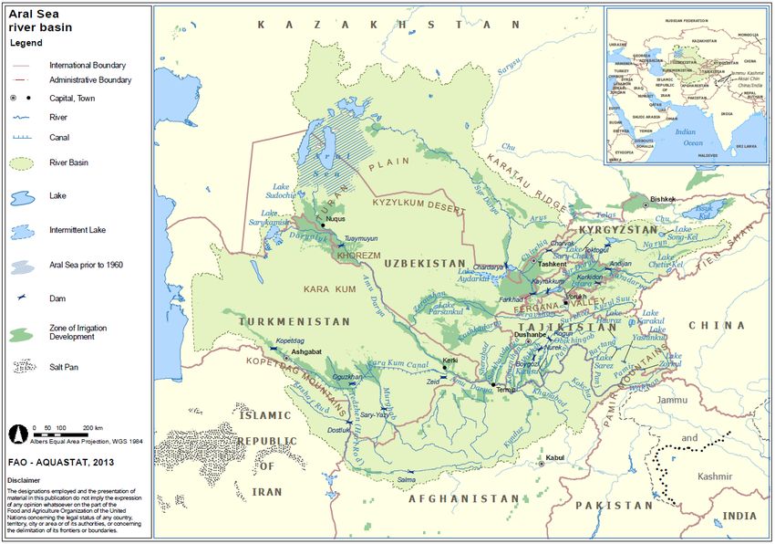
Figure 1
Aral Sea River BasinAral Sea transboundary river basin 3
desert, less than 10 percent is mountainous. Just over 10 percent of the mean annual runoff in the Aral
Sea basin is generated in these three countries.
The Aral Sea basin includes the Syr Darya and Amu Darya, the Tedzhen (known as Hari Rod in
Afghanistan) and Murghab rivers, the Kara Kum canal linking the Amu Darya, Murghab and Tedzhen
rivers, shallow rivers flowing from Kopet Dag and western Tien Shan, as well as the areas with no runoff
between these rivers and around the Aral Sea. In Kazakhstan, the flows from the Torgai, Sarysu, Chu
and Talas rivers are lost in the desert or are directed to natural depressions. These rivers are not
considered part of the Aral Sea basin.
Before 1960, the Aral Sea ranked as the world’s fourth largest lake, after the Caspian Sea, the Great
Lakes in North America and Lake Chad, since then it has been progressively drying up (Figure 1).
Climate
The climate is continental, determined by the landlocked position of Central Asia within the Eurasian
continent. Large daily and seasonal temperature differences are characteristic of the region, with high
solar radiation and relatively low humidity. Terrain and altitude range from 0 to 7 500 m above sea level
(asl), leading to greatly diversified microclimates. Although this area is often subject to humid winds,
the mountains trap most of the moisture, leaving little precipitation for the other areas of the Aral Sea
basin (CAWaterInfo, 2011).
The average temperatures range from 0–4 ºC in January and 28–32ºC in July. In some areas, summer
temperatures may be as high as 52 ºC and winters as cold as minus 16ºC, with an absolute minimum of
minus 38ºC, creating a sharply contrasting overall climate, with hot summers and cold winters (Murray-
Rust et al., 2003).
Annual precipitation in the lowlands and valleys is between 80 and 200 mm, concentrated in the winter
and spring, while on the foothills precipitation is between 300 and 400 mm, and on the southern and
southwestern sides of the mountain between 600 and 800 mm.
Because of the large differences in summer air humidity between the ancient oases and the newly
irrigated areas, 50–60 percent and 20–30 percent respectively, water demands in the former desert –
now under irrigation – are significantly higher than around the oases. The second factor, which
particularly affects agricultural production, is the instability of spring temperatures and precipitation.
Late frosts may occur at the beginning of May with hail in June, which sometimes destroys emerging
cotton plants and vegetables over large areas (CAWaterInfo, 2011).
Population
The Aral Sea basin is a diverse region with approximately 46 million people in 2006 while in 1960 and
1980 the population was 15 million and 27 million people respectively (Sokolov, 2009). In 2010, access
to improved water sources varied from 50 percent in Afghanistan to 96 percent in the Islamic Republic
of Iran (Table 2).
TABLE 2
Access to improved water sources (Source: JMP, 2011)
Access to improved water sources (% of population)
Country
National Urban Rural
Afghanistan 50 78 42
Islamic Republic of Iran 96 97 92
Kazakhstan 95 99 90
Kyrgyzstan 90 99 85
Tajikistan 64 92 54
Turkmenistan 84 97 72
Uzbekistan 87 98 814 Irrigation in Central Asia in figures - AQUASTAT Survey - 2012 WATER RESOURCES Mountains and glaciers play an important role in water storage. They can store precipitation as snow and ice in winter and deliver it as snow melt to rivers and associated alluvial aquifers during the dry summer season (July and August) (Rakhmatullaev et al., 2009). Surface water The two major river basins in the Aral Sea basin are the Amu Darya in the south and the Syr Darya in the north. A third river basin, the Tedzhen-Murghab basin, is located in the southwest. Some thirty primary tributaries feed the basins. However, today, many of the tributaries only flow seasonally – drying up before reaching the main rivers. The main rivers originate in mountainous regions – the Pamir and Tien Shan ranges – where there is surplus moisture (precipitation of 800–1 600 mm and potential evapotranspiration of 100–500 mm), resulting in permanent snowfields and glaciers (Murray-Rust et al., 2003). Amu Darya basin The Amu Darya basin is divided into two unequal parts: the smaller upstream to the southeast, characterized by the high mountain ranges of Central Pamir and Tien Shan with an altitude of 5 000– 6 000 m, and the larger area downstream to the northwest, where plains dominate the landscape and elevations are no higher than 200 m. Despite the very arid conditions of the region, the high mountain ranges facilitate the formation of important water-courses that behave as a huge feeding reservoir (Rakhmatullaev et al., 2009). The Amu Darya is the longest river in Central Asia and the second longest in Afghanistan. Six countries share the river Afghanistan, Kazakhstan, Kyrgyzstan, Tajikistan, Turkmenistan and Uzbekistan. Rising in Afghanistan, Kyrgyzstan and Tajikistan, the Amu Darya flows 2 540 km from the headwaters of the Panj (Pyandzh) to the Aral Sea. The river is named Amu Darya from the point where the Panj river joins the Vakhsh river in the Pamir mountains. The Vakhsh river rises in Kyrgyzstan, where it is named the Kyzyl Suu. This is the longest river in Tajikistan, crossing from the northeast to the southwest, its catchment area lies at over 3 500 m in the highest part of Tajikistan. The Vakhsh river takes its name from the confluence of the Surkhob and Obikhingob rivers. The Panj river, the largest tributary of the Amu Darya, originates in the Pamir mountain ranges and forms the border between Tajikistan and Afghanistan for almost its entire length flowing from east to west. After the confluence of the Panj and Vakhsh rivers, it becomes the Amu Darya and about 100 km further downstream it leaves Tajikistan to become the border between Afghanistan and Uzbekistan. The Kofarnihon river rises in Tajikistan and flows into the Amu Darya about 36 km downstream of the confluence of the Panj and Vakhsh rivers. The Kofarnihon river flows mainly in Tajikistan and forms the border between Tajikistan and Uzbekistan over a short distance before flowing into the Amu Darya. Two other large right tributaries, the Surkhandarya and Sherabad rivers, and two left tributaries, the Kunduz and Kokcha rivers, flow into the Amu Darya in the middle reach. Further downstream towards the Aral Sea, the Amu Darya has no tributaries. Two rivers, the Zeravshan and Kashkadarya rivers, are similar to the Amu Darya for their water catchment characteristics however; they no longer discharge into the Amu Darya (Rakhmatullaev et al., 2009). The Zeravshan, which rises in Tajikistan, used to be the largest tributary of the Amu Darya before it began to be tapped for irrigation, mainly by Uzbekistan. Now the Zeravshan evaporates in the Kyzylkum desert near the city of Bukhara. Total river flow from Tajikistan to Uzbekistan is 3.09 km3/year; all these water resources are allocated to Uzbekistan.
Aral Sea transboundary river basin                                                                     5

In Afghanistan, the rivers of the northern basin originate on the northern slopes of the Hindu Kush and
flow northwards towards the Amu Darya river. However, most of these rivers die out on the Turkistan
plains before reaching the Amu Darya. From west to east, the main rivers include the Shirin Tagab, the
Sarepul, the Balkh and the Khulm rivers.

The Amu Darya is fed largely by water from melted snow, thus maximum discharges are observed in
summer and minimum in January-February. This year-round availability of the flow favours the use of
the river water for irrigation during the dry summer. While crossing the plain, from Kerki in
Turkmenistan to Nuqus in Uzbekistan, the Amu Darya loses most of its flow to evaporation, infiltration
and irrigation withdrawal. The basin’s total long-term average annual runoff is 78.46 km3. The long-
term average annual flow in the Amu Darya basin from Kyrgyzstan to Tajikistan – through the Kyzul
Suu river – is 1.93 km3 or about 2 percent of the total flow of the Amu Darya.

The main flow of the Amu Darya originates in Tajikistan: about 59.45 km3, including 3.09 km3 of the
Zeravshan river, or 76 percent of the total flow. The Amu Darya then flows along the border between
Afghanistan and Uzbekistan, across Turkmenistan and returns to Uzbekistan where it discharges into
the Aral Sea. About 11.7 km3 (not including 1.9 km3 of the northern basin, which mainly evaporates
before reaching the Amu Darya) or 15 percent of Amu Darya water is formed in Afghanistan. The
internal contribution of Turkmenistan to the river is 0.68 km3 or 1 percent. The internal contribution of
Uzbekistan to the river is 4.7 km3 or 6 percent.

The share of the Amu Darya flow allocated to Turkmenistan and Uzbekistan is 50 percent each of the
actual river flow at the Kerki gauging station. This share is based on an agreement between Uzbekistan
and Turkmenistan signed in January 1996, which supplemented the 1992 Agreement signed by the five
Central Asian countries. The Turkmen and Uzbek allocation corresponds to 42.27 percent of the share
of the Amu Darya surface water resources on which agreements have been concluded. The agreements
are calculated based on about 67 percent of the total flow produced in the Amu Darya basin, which is
on average 78.46 km3/year. This is calculated by adding the long-term average annual internal renewable
surface water resources (IRSWR) of the basin in the different countries: Kyrgyzstan 1.93 km3, Tajikistan
59.45 km3, Uzbekistan 4.70 km3, Afghanistan 11.70 km3 and Turkmenistan 0.68 km3.

The actual surface water resources allocated to Turkmenistan and Uzbekistan are calculated every year,
depending on the actual flow. On average, water resources allocated to Turkmenistan in the Amu Darya
basin are about 22 km3/year, including 0.68 km3/year of IRSWR, and 22 km3/year to Uzbekistan, which
includes 3.09 km3 of the Zeravshan river. Even though Afghanistan is not part of the five states of the
Former Soviet Union, and therefore not part of the agreement, allocations between the five states include
the flow of 11.7 km3/year, which is measured at Kerki station in Turkmenistan.

Syr Darya basin

The Syr Darya is the second most important river in Central Asia for water resources it flows 3 019 km
from the Naryn headwaters in Kyrgyzstan. The Syr Darya originates in the Tien Shan mountains, runs
through the upstream countries of Kyrgyzstan and Tajikistan and then through Uzbekistan and
Kazakhstan into the Aral Sea (Murray-Rust et al., 2003). The river is known as the Syr Darya after the
point where the Naryn joins with the Karadarya in Uzbekistan. Glaciers and snow melt feed the river,
mostly the latter. The water regime is characterized by a spring-summer flow, which begins in April.
Discharge is highest in June.

The total long-term average annual runoff of the Syr Darya basin is 36.57 km3. About 27.42 km3 or 75
percent is formed in Kyrgyzstan, which is the flow from Kyrgyzstan to Uzbekistan, of which 22.33 km3
is secured by agreements. Of this, 11.8 km3/year is transit flow to Tajikistan secured by agreements.
Only 3 percent of the Syr Darya is generated within Tajikistan by the shallow rivers Khodzhabakirgan,
Isfara and Isfana, with a total flow of 1.01 km3/year. The annual flow at the border between Tajikistan
and Uzbekistan, is 11.54 km3 of which 10 km3 is transit flow to Kazakhstan, as secured by agreements.
6                                                         Irrigation in Central Asia in figures - AQUASTAT Survey - 2012

On average, the contribution of Uzbekistan to the Syr Darya is 4.84 km3 or 13 percent, and the
contribution of Kazakhstan is 3.3 km3 or 9 percent.

The largest tributaries of the Syr Darya within Kazakhstan are the Keles, Arys, Badam, Boroldai, Bugun
and smaller rivers, flowing from the southwestern slopes of the Karatau ridge.

Tedzhen-Murghab basin

Afghanistan is the source of the Murghab and Tedzhen rivers of the Aral Sea basin. They terminate in
Turkmenistan, although the Tedzhen also travels across the Islamic Republic of Iran (Horsman, 2008).
The main flow of the Tedzhen and Murghab together is 3.1 km3 in Afghanistan and 0.3 km3 in
Turkmenistan. The Tedzhen waters are covered by a treaty, signed in February 1926 between the Islamic
Republic of Iran and Turkmenistan, which remains in force. This treaty stipulates that each year
Turkmenistan receives a quantity equal to 70 percent of the total Tedzhen average runoff, which
corresponds to an average of 0.75 km3.

Aral Sea basin

The total mean annual flow of all rivers in the Aral Sea basin is an estimated 118.43 km3 (Table 3). In
accordance with flow probabilities of 5 percent (wet years) and 95 percent (dry years), the annual flow
ranges from 108 to 47 km3 for the Amu Darya river and from 54 to 21 km3 for the Syr Darya river
respectively.
TABLE 3
Mean annual runoff in the Aral Sea basin (km3/year)
                                                    River basin                               Total Aral Sea basin
             Country
                                   Syr Darya      Amu Darya       Tedzhen-Murghab             km3                %
    Kazakhstan                            3.30                                                      3.30              2.8
    Kyrgyzstan                          27. 42           1.93                                      29.35             24.8
    Tajikistan                            1.01         *59.45                                      60.46             51.0
    Turkmenistan                                         0.68                     0.3               0.98              0.8
    Uzbekistan                            4.84           4.70                                       9.54              8.1
    Afghanistan                                         11.70                    3.1               14.80             12.5
    Islamic Republic of Iran                                                     n.a.                   -               -
    Aral Sea basin                       36.57         78.46                     3.4              118.43              100
n.a.       not available
*          Includes 3.09 km3 of Zeravshan river

There are no significant anthropogenic changes in the upstream zone of flow formation. However,
because of the construction of large dams on the border of this area, the downstream runoff regime is
changing. Because of significant losses in the desert areas, and because of major agricultural water
withdrawal, the flow reaching the Aral Sea is limited to a small percentage of these annual flows. In the
driest years this corresponds to less than 10 percent for Amu Darya and less than 5 percent for the Syr
Darya.

Groundwater

The groundwater resources of the Aral Sea basin can be divided into two parts: the natural flow or
primary freshwater from the mountainous and water catchment areas, and groundwater filtrated from
hydro-technical structures and irrigated land (secondary freshwater). Estimated reserves of Central Asia
countries (Afghanistan not included) are about 31.1 km3, of which 14.7 km3 are in the Amu Darya basin
and 16.4 km3 in Syr Darya basin. Because exploitation of groundwater may impact surface water flows,
the quantification of groundwater resources must be carefully carried out to identify the portion of the
reserves that can be used without significantly diminishing surface runoff. The reserves confirmed for
extraction are an estimated 13.1 km3 per year (CAWaterInfo, 2011).
Aral Sea transboundary river basin 7 Average annual groundwater recharge in Afghanistan is an estimated 2.97 km3 in the Amu Darya basin, 0.64 km3 in the Tedzhen basin and 2.14 km3 in the Murghab and northern basins. In Kyrgyzstan groundwater recharge is an estimated 0.23 km3 in the Amu Darya basin and 5.25 km3 in the Syr Darya basin. Average annual groundwater recharge in Uzbekistan, which is entirely located in the Aral Sea basin, is an estimated 8.8 km3, while in Tajikistan it is 6 km3. There are no detailed figures by basin for Kazakhstan and Turkmenistan. It should be noted, however, surface water and groundwater resources cannot be added to obtain total renewable water resources. This is because of the overlap between surface water and groundwater as a result of seepage from rivers into aquifers and groundwater drainage into rivers (base flow of rivers). Natural lakes, reservoirs and non-conventional sources of water There are many natural lakes in the mountainous areas and ravines of Central Asia. Most of the large lakes occupy basins that resulted from tectonic activity (Issyk-Kul, Song-Kel, Chetir-Kel, Karakul, Sarichelek). Lakes resulting from landslides, caused by earthquakes, are the Sarez and Yashinkul in the Pamir mountains. Numerous lakes are of glacial origin; one of the largest is the Zorkul, located at 4 125 m in the Eastern Pamir. Karst lakes are also present. In the mountains, lakes are usually freshwater or slightly saline, depending on the quality of inflowing water. Initial assessments of freshwater reserves in mountain and lowland lakes suggest a volume of 60 km3 (CAWaterInfo, 2011). Many artificial lakes have been created, most are shallow. The largest of these lakes in the region are Sarykamish, in the lower reaches of the Amu Darya and Aydarkul, in the middle reach of the Syr Darya. Large volumes of water are discharged into Aydarkul lake during high water years from the Chardarya reservoir, on the border between Kazakhstan and Uzbekistan. In the last few years, this has been common practice in winter to create energy from the Naryn-Syr Darya hydropower cascade. The volume of water resources found in artificial lakes is an estimated 40 km3 (CAWaterInfo, 2011). Return flow forms a high proportion of water resources in the basin and is a major source of pollution. In recent years, the annual mean values of return flow, comprised of drainage water from irrigation and wastewater from industry and municipalities have varied between 28 km3 and 33 km3. About 13– 15.5 km3 annually form in the Syr Darya basin, and about 15–18 km3 in the Amu Darya basin. The total amount makes up about 95 percent of drainage water and about 5 percent of untreated municipal and industrial wastewater. The high percentage of drainage water demonstrates that irrigation actually consumes only about 45–50 percent of total agricultural withdrawals (CAWaterInfo, 2011). In 1993, about 6 km3 of agricultural drainage water or wastewater were directly used for irrigation. One of the principal goals of water managers is to minimize losses. Drainage water is highly saline: 2– 3 g/litre from April to September and 5–12 g/litre during autumn and winter. The quality of the drainage effluent depends on the location of the irrigation scheme within the river basin – upper, middle, or lower reaches – and the leaching requirements of the irrigated area. It also depends on the use of agrochemicals. Local salt mobilization is determined in part by the type of drainage system (open, subsurface or vertical), seepage, drain spacing and drain depth. The poor quality limits the direct use of drainage water, especially for irrigation. Only about 15 percent of total return flow is directly used and more than 55 percent returns to rivers. About 30 percent ends up in natural depressions, from which the water evaporates (CAWaterInfo, 2011). WATER-RELATED DEVELOPMENTS IN THE BASIN Agriculture The rural population in the Aral Sea basin is mainly employed in farming. Out of 60 million ha that are considered cultivable (Afghanistan and the Islamic Republic of Iran are not included) only about 10 million ha are actually used. Half of the actually cultivated land is located on the fertile soils of the oases, which are naturally drained. The other half requires complicated and expensive reclamation
8                                                        Irrigation in Central Asia in figures - AQUASTAT Survey - 2012

measures before it can be used, including drainage and land levelling and improvement of the soil
structure. Land availability varies greatly between the countries. Kazakhstan and Turkmenistan have
good land availability, while land is scarce in Tajikistan and Kyrgyzstan and in some areas of
Uzbekistan, such as Khorezm, the Fergana valley and Samarkand provinces.

This situation, plus water scarcity, causes friction between the countries, provinces and tribes. The
significance of large-scale development of desert areas during the Soviet period, such as Golodnaya
steppe, Karshi steppe, areas along the Kara Kum canal, Asht and Lylak systems, was they allowed the
resettlement of hundreds of thousands of people from more populated areas. Such enormous
undertakings are no longer a viable option for these post-Soviet, independent and economically weak
countries. Thus decision should be based only on the improvement of available resources and not on
major new developments (CAWaterInfo, 2011).

Irrigation plays an important role in the economies of Central Asia. While some areas have been irrigated
for centuries, central planning created many irrigation and drainage schemes in the 1950s–1980s. In the
1960s, Soviet policy assigned Central Asia the role of supplier of raw material, notably cotton. Irrigation
was necessary because of the mainly arid climate in the lower reaches of the Amu and Syr Darya basins.
The development of irrigation in the Soviet area of the Aral Sea basin was spectacular: from about 4.5
million ha in 1960 to almost 7 million ha in 1980. Huge schemes were constructed to irrigate desert or
steppes and hundreds of thousands of people moved to the areas to work in agriculture. From 1970 to
1989 the irrigated area expanded by 150 percent in the Amu Darya basin and 130 percent in the Syr
Darya basin (World Bank, 2003).

Some 32.6 million ha are considered suitable for irrigation in the Aral Sea basin. Currently, the total
area equipped for irrigation is around 9.76 million ha (Table 4). The area equipped for irrigation in the
Amu Darya basin is an estimated 6 million ha of which 1.3 million ha in northern Afghanistan, 0.1
million ha in Kyrgyzstan, 0.5 million ha in Tajikistan, 1.8 million ha in Turkmenistan and 2.3 million
ha in Uzbekistan (Sokolov, 2009; Horsman, 2008; Rout, 2008).

TABLE 4
Irrigation in the Aral Sea basin (Adapted from: Sokolov, 2009; Horsman, 2008; Rout, 2008)
                                   Area equipped for           As % of         Area actually irrigated    AAI as % of
            Country                 irrigation (AEI)            total                  (AAI)                  AEI
                                       (million ha)              (%)                 (million ha)             (%)
    Afghanistan                              1.30                     13                    0.77                 59
    Kazakhstan                               1.30                     13                    0.83                 64
    Kyrgyzstan                               0.42                      4                    0.42                100
    Tajikistan                               0.74                      8                    0.67                 91
    Turkmenistan                             1.80                     19                    1.80                100
    Uzbekistan                               4.20                     43                    3.70                 88
    Aral Sea basin                           9.76                    100                    8.19                 84

More than 90 percent of the Aral Sea basin’s crops are produced on irrigated land (Horsman, 2008).
Currently, rainfed land does not play a significant role in total agricultural production in the Aral Sea
basin, with the exception of extensive (semi-nomadic) livestock husbandry (cattle and sheep).
Nonetheless, increasing the productivity of non-irrigated land is an important goal. Some crops (e.g.
cereals), which are grown increasingly in irrigated areas, could be moved to non-irrigated areas thus
substantially reducing the volume of irrigation water withdrawn in the basin (CAWaterInfo, 2011).

Since independence, the irrigated land area has not changed significantly in Central Asian countries,
with the exception of Turkmenistan where the area of irrigated land during 1995–1996 increased by
about 400 000 ha. However, there have been major changes in cropping patterns. Cotton is still one of
the most important crops, although between 1990 and 1998 its share of irrigated agriculture decreased
from 45 to 25 percent. In the same period, the area under cereals (wheat, rice, maize and others)
increased from 12 to 77 percent. Wheat became the dominant crop in the region, which covers about 28
percent of total irrigated area. Fodder crops in 1998 occupied less than 20 percent of the total irrigated
area, compared to 27 percent in 1990, which is highly undesirable from the viewpoint of maintaining
soil fertility and crop rotation (CAWaterInfo, 2011).
Aral Sea transboundary river basin 9 Large-scale irrigated farming in the Aral Sea Basin is based on a well-developed system of irrigation and drainage facilities. By the end of 1998, the overall length of main and inter-farm irrigation networks in the basin was 47 750 km and on-farm irrigation networks totalled 268 500 km. Irrigation in Central Asia, and particularly in Uzbekistan, relies on a system of pumps and canals that is among the most complex in the world. Since 1990, on-farm irrigation networks have deteriorated as a result of the poor financial situation of both state-owned and privatized farms, which are unable to reconstruct on-farm networks or maintain them in a satisfactory condition (CAWaterInfo, 2011). In 1960, total water withdrawal in the Aral Sea basin was an estimated 64.7 km3. In 2006, it was an estimated 107 km3 of which irrigation withdrawal accounted for 96 km3, or 90 percent of the total (Sokolov, 2009). Most of the Amu Darya water is withdrawn by Turkmenistan and Uzbekistan along the section of their common border (Stanchin and Lerman, 2006). Uzbekistan accounts for approximately 56 km3 (50 km3 in agriculture) and Tajikistan for 11 km3 (10 km3 in agriculture). Withdrawal of water per irrigated hectare in the Aral Sea Basin is high, in the order of 11 000– 14 000 m3/ha or even more (World Bank, 2003). During the Soviet period groundwater resources were not widely used for irrigated agriculture in the Central Asian Republics. This is because farmers received sufficient surface water, and had a reliable water supply and irrigation infrastructure. During this period groundwater resources were used primarily for the livestock sector and drinking water supply in both urban and rural areas. The Aral Sea basin countries began useing groundwater during the drought years (1998–2001) to sustain vital agricultural production. Groundwater is of relatively good quality and quantity and provides an alternative to highly salinized surface water. Afghanistan has traditionally relied upon surface water and groundwater springs and karezes (constructed underground channels) for irrigated agriculture and the share of groundwater irrigation of the cultivated area is around 18 percent. During recent drought years in the Aral Sea basin, the use of deeper groundwater, abstracted from dug wells and boreholes increased rapidly. Private farmers drilled many new wells and boreholes and, in some areas, groundwater abstraction rates are already exceeding, or will soon exceed, sustainable groundwater resources (Rakhmatullaev et al., 2009). Total groundwater extraction in the Aral Sea basin is around 10 km3 (CAWaterInfo, 2011). The largest and most important artificial waterway in Turkmenistan is the Kara Kum canal. This canal was constructed in the 1950s and is the longest canal in the world with 1 300 km. Canal capacity is an estimated 630 m3/s. The canal’s inlet on the Amu Darya is just after the river enters Turkmenistan from Uzbekistan. The Kara Kum canal pools the Amu Darya, Murghab and Tedzhen rivers into an integrated water management system. It supplies water to the densely populated south of the country and irrigates more than 1.2 million ha. The canal brings water to Ashgabat and to the oases in the south. Each year it takes 10–12 km3 from the Amu Darya (Orlovsky and Orlovsky, after 2002). During the Soviet period, water allocation and irrigation system infrastructure were well maintained and operated, with massive funding coming from the central government. Since the Central Asian countries gained independence, the situation changed dramatically, politically, institutionally as well as technically. The political transition from a planned economy to a market economy introduced ‘new’ concepts such as land tenure, water rights and different kinds of ownership. The institutional changes are described as a transition from former state collective farms – kholkhoz and sovkhoz – into smaller private farms. Many farmers, however, do not have the capacity to pump and irrigate land on an individual basis (Rakhmatullaev et al., 2009). Salinization and drainage Climatic and hydro-geological conditions make the soil in the Aral Sea basin particularly vulnerable to salinization. Some land, especially in the inter-mountain valleys, is initially salt affected as a result of the arid climate. The process of salt accumulation is intensified under the influence of pressure from
10                                                    Irrigation in Central Asia in figures - AQUASTAT Survey - 2012

deep saline artesian water and the following two factors: (a) additional infiltration of irrigation water to
the drainage network, (b) deterioration of downstream water quality. This is the result of natural
evaporation processes, the use of overly saline irrigation water as well as naturally poor drainage
conditions. The intensity of irrigation in Central Asia requires artificial drainage to control waterlogging
and salinization. In 1994, about 40 percent of irrigated land in the basin was saline and groundwater salt
content in the lower reaches of the river basins varied between 1 and 30 g/litre. Currently, about 5 million
ha have drainage systems, of which about 60 percent is surface drainage, 26 percent subsurface, and
14 percent vertical drainage (tubewells). Uzbekistan has the largest area of artificially drained land in
Central Asia.

Several innovations have been made to drainage design to address seepage from irrigation canals and
upstream irrigation, percolation from excess irrigation water, groundwater fluxes to the root zone and
the accompanying salts moving into the crop root zone. Deeper subsurface drainage depths are
considered essential to control waterlogging and salinity. Significant investments were made in drainage
in the region until the 1990s. However, with the demise of the Union of Soviet Socialist Republics
(USSR), and the deterioration of economic conditions in Central Asia, investment in drainage declined.
Drainage systems are no longer properly maintained and the areas suffering from salinization and
waterlogging have been increasing (Dukhovny et al., 2007).

Dams and hydropower

More than 80 water reservoirs were constructed in the Aral Sea basin, each with a capacity of over
10 million m3. In order to modify natural river flow patterns to those needed for water supply, reservoirs
were constructed either on rivers (off-stream and river-channel reservoirs) or on main canals
(compensation reservoirs) (CAWaterInfo, 2011).

There are more than 45 hydropower plants in the Aral Sea basin, the total capacity of which exceeds
34.5 GW, ranging from 50 to 2 700 MW. The largest hydropower plants are Nurek in Tajikistan on
Vakhsh river, with a capacity of 2 700 MW, and Toktogul in Kyrgyzstan on Naryn river, with a capacity
of 1 200 MW. Hydropower makes up 27.3 percent of average energy consumption in the Aral Sea basin.
Potentially, the region can meet more than 71 percent of its energy requirements from hydropower
(CAWaterInfo, 2011).

Afghanistan has no dams in the Aral Sea basin, although the Salma Dam for hydroelectricity is under
construction on the Hari Rod river. Originally constructed in 1976, it was damaged early during the civil
war. In 2006, India committed to funding the completion of the Salma dam. On completion the
hydroelectric plant should produce 42 MW in addition to providing irrigation to 75 000 ha, including
stabilization of existing irrigation on 35 000 ha and development of irrigation facilities on an additional
40 000 ha.

In Kazakhstan, the Chardarya dam (5.2 km3) is the only dam on the Syr Darya, located at the border
with Uzbekistan and connected to hydroelectric power stations.

In Kyrgyzstan there are nine reservoirs in the Syr Darya basin, with a total capacity of 22.3 km3. The
Toktogul dam, with a reservoir capacity of 19.5 km3, on the Naryn river, a northern tributary of the Syr
Darya. The dam is multipurpose used for irrigation, hydropower production and flood
protection/regulation. However, because it is located near the border with Uzbekistan, it does not play
an important role in the irrigation of areas within Kyrgyzstan. In 1985, gross theoretical annual
hydropower potential in Kyrgyzstan was an estimated 162 500 GWh and economically feasible potential
about 55 000 GWh. The installed capacity of hydropower is about 3 GW, a number of hydropower
plants are part of the Naryn-Syr Darya cascade, which are controlled by the Toktogul dam. Hydropower
plays a key role in Kyrgyzstan and is the country's main source of energy (about 90 percent of electricity
generation in 1995), given its limited gas, oil and coal resources.
Aral Sea transboundary river basin                                                                     11

In 2010, there were 17 dams in Tajikistan: four in the Syr Darya basin and 13 in the Amu Darya basin
of which eight on Vakhsh river, two on Panj river and three on the Kofarnihon river. Their total reservoir
capacity is about 29.5 km3, including the Rogun reservoir on the Vakhsh river (13.3 km3), which is under
construction with completion of its first phase in 2012.

The largest reservoirs are: the Nurek on the Vakhsh river (10.5 km3), the Kayrakkum on the Syr Darya
(4.16 km3), the Farkhad on the Syr Darya (350 million m3), the Boygozi on the Vakhsh river
(125 million m3), the Kattasoy on the Kattasoy river (55 million m3), the Muminabad on the Obi Surkh
river (31 million m3), the Dahanasoy on the Dahanasoy river (28 million m3) and the Sangtuda 1 on the
Vakhsh river (25 million m3). The Sangtuda 2 reservoir (5 million m3) on the Vakhsh river was
inaugurated in 2011.

The Nurek headwork incorporates a unique rock-fill dam with a central core, 310 m high, there is a
power plant with a capacity of 3 000 MW. Nurek and Kayrakkum reservoirs reserve water to irrigate
Uzbekistan, Turkmenistan and Kazakstan. In 1999, Tajikistan ranked third in the world for hydropower
development, after the United States and the Russian Federation. In 1994, total installed capacity was
about 4 GWh, generating about 98 percent of the country’s electricity.

In Turkmenistan, total dam capacity accounted for about 6.22 km3 in 2004. All reservoirs were designed
and constructed mainly for irrigation purposes, and are affected by heavy siltation. There are five dams
with a capacity of more than 0.5 km3: Zeid on the Kara Kum canal (2.20 km3), Dostluk on the Tedzhen
river (1.25 km3), Oguzkhan on the Kara Kum canal (0.88 km3), Sary-Yazy on the Murghab river
(0.66 km3) and Kopetdag on the Kara Kum canal (0.55 km3). The Dostluk dam, on the border between
the Islamic Republic of Iran and Turkmenistan, is designed for flood control, hydropower generation
and flow regulation. In 1993, the gross hydropower potential was an estimated 5.8 GWh, while total
installed capacity was about 0.7 GWh. The contribution of hydropower to general energy consumption
in Turkmenistan is only about 1 percent.

Most of the large dams in the Aral Sea basin are in Uzbekistan. In the Syr Darya basin, the largest
reservoirs are the Charvak reservoir, one of the largest hydropower plants in Central Asia is located on
the Chirchiq river, which has a capacity of 1.99 km3 and 600 MW, and the Andijan reservoir on the
Karadarya river in the Fergana valley with a capacity of 1.90 km3. In the Amu Darya basin, the largest
reservoir is the Tuaymuyun, in Khorezm vilayat, with a storage capacity of 7.8 km3, comprised of four
separate reservoirs. In the future it is expected that one reservoir in this system (Kaparas) will be used
to provide drinking water to Karakalpakstan. This area is experiencing severe environmental problems
as a result of the shrinking of the Aral Sea. In Uzbekistan, total installed capacity in 1993 was 1.7 GW,
which provided about 12 percent of the country’s electricity.

Table 5 shows the existing major dams, larger than 0.1 km3, with details on height and capacity, where
information was available.
12 Irrigation in Central Asia in figures - AQUASTAT Survey - 2012
TABLE 5
List of major dams (> 0.1 km3) in the Aral Sea river basin
Height Capacity
Country Name Nearest city River (Major basin) Year Main use *
(m) (million m3)
Afghanistan - - - - - - -
Kazakhstan Chardarya Chardarya Syr Darya (SD) 1968 27 5 200 I,H,W,F
Kyrgyzstan Toktogul Tash Kumur Naryn (SD) 1974 215 19 500 I, H
Kurpsay Tash Kumur Naryn (SD) 1981 110 370 I, H
Papan Osh Ak-Bura (SD) 1981 120 260 I, H
Tajikistan Rogun** Rogun Vakhsh (AD) 2012 335 13 300 I,H,F
Nurek Nurek Vakhsh (AD) 1980 300 10 500 I,H,W,F
Kayrakkum Khujand Syr Darya (SD) 1959 32 4 160 I,H
Farkhad*** Khujand Syr Darya (SD) 1948 24 350 I,H,W,F
Boygozi Nurek Vakhsh (AD) 1989 54 125 I,F,H
Turkmenistan Zeid Turkmenabat Kara Kum Canal (AD) 1986 12 2 200 I,W
Dostluk Saragt Tedzhen (AD) 2004 n.a. 1 250 I,H,W,F
Oguzkhan Mary Kara Kum Canal (AD) 1975 n.a. 875 I,W
Sary-Yazy Tagtabazar Murghab (AD) 1984 25.5 660 I,W,F
Kopetdag Geoktepe Kara Kum Canal (AD) 1987 n.a. 550 I,W
Tedzhen-1 Tedzhen Tedzhen (Tejen) (AD) 1950 n.a. 190 I,W,F
Tedzhen-2 Tedzhen Tedzhen (Tejen) (AD) 1960 20.5 184 I,W,F
Yolotan Yolotan Murghab (AD) 1910 n.a. 120 I,W,F
Uzbekistan Tuaymuyun Pitnak Amu Darya (AD) n.a. n.a. 7 800 n.a.
Charvak Tashkent Chirchiq (SD) 1977 168 1 990 I,H
Andijan Andijan Karadarya (SD) 1980 121 1 900 I
Pachkamar n.a. Guzar (AD) 1961 71 1 525 I
Talimarjan Jangi-Nishon Karshi canal (AD) 1985 635 1 525 I
Tudakulskaya natural
Tudakul Navoji 1983 12 1 200 I
depression (AD)
Kattakurgan n.a. Zeravshan (AD) 1953 31 900 I
Yuzhnosurkhan Shurchi Surkhandarya (AD) 1967 30 800 I
Chimkurgan Chirakchi Kashkadarya (AD) 1963 33 500 I
Tupalang Shargun Tupalang (AD) 2002 180 500 I
Shorkul Navoji Zeravshan (AD) 1984 15 394 I
Farkhad*** n.a. Syr Darya (SD) 1948 24 350 I,H,W,F
Kuyumazar Navoji Zeravshan (AD) 1958 24 310 I
Tashkent n.a. Chirchiq (SD) 37 250 I
Isfayramsay along the
Karkidon Kuba 1967 70 218 I
Kuvasay channel (SD)
Akhangaran Angren Akhangaran (SD) 1989 100 198 I
Gissar n.a. Aksu (AD) 1990 139 170 I
Kasansai n.a. Kasansai (SD) 1968 64 165 I
Zang canal, Termiz canal,
Uchkyzyl n.a. 1957 12 160 I
Surkhandarya river (AD)
Aktepin n.a. Surkhandarya (AD) n.a. 14 120 I
Akdarin n.a. Akdarya (AD) n.a. 20 112 I
Jizzakh Jizzakh Gully of Djailmasay (SD) 1973 20 100 I
n.a.: Information not available; SD: Syr Darya major basin; AD: Amu Darya major basin
* I = irrigation; H = Hydropower, W = Water Supply; F = Flood protection
** Under construction at the time of writing, 1st phase is expected to be finished in 2012
*** The Farkhad dam is shared by Tajikistan and Uzbekistan
ENVIRONMENT, WATER QUALITY AND HEALTH
Irrigation water withdrawal from both the Syr Darya and the Amu Darya continuously reduces the
volume of the remaining runoff in the rivers and inflow into the Aral Sea. During the summer months,
when demand for irrigation is at its highest, little water reaches the Sea. Diversions for irrigation, and
relatively large amounts of water used for leaching and to upstream reservoirs to produce electricity,
have reduced important winter flows to the sea (Murray-Rust et al., 2003). The environmental
consequences of the huge irrigation development in the Aral Sea basin are numerous:
Many tributaries have been exploited to such an extent that they no longer contribute directly
to the flow of the Amu Darya and Syr Darya. They are: the Zeravshan and Kashkadarya in the
Amu Darya basin, and the Arys and Akhangaran in the Syr Darya basin.
The intensification of irrigated agriculture has led to major waterlogging and salinization.
At the end of the 1960s water salinity did not exceed 1 g/litre, even in the lower reaches.
Currently, it varies from 0.3–0.5 g/litre in the upper reaches to 1.7–2.0 g/litre in the lowerAral Sea transboundary river basin 13
reaches. The highest values occur in March and April in the upper reaches, and around May in
the lower (CAWaterInfo, 2012).
Agriculture in the Aral Sea basin has been practised with a high level of inputs, particularly
fertilizers and pesticides, and this has resulted in the deterioration of surface water and
groundwater quality. There is also pollution from industrial and municipal waste, especially
from metropolitan areas.
The traditional ecosystem of the two deltas of the Amu Darya and Syr Darya has perished. The
marshes and wetlands, which covered some 550 000 ha and were a reservoir of biodiversity
until the 1960s, have almost disappeared (only 20 000 ha were left in 1990) giving way to
sandy deserts. More than 50 lakes, covering 60 000 ha in the deltas, have dried up.
The Aral Sea is drying up. Before 1960, the level of the Aral Sea was more or less stable. Its
surface area was about 66 000 km2 and its volume about 1 060 km3. The combined average
discharge of the Amu Darya and Syr Darya to the sea was about 47–50 km3/year, to which
could be added 5–6 km3/year of groundwater inflow and 5.5–6.5 km3/year of precipitation over
the sea. This total volume of 57.5–62.5 km3/year compensated for the evaporation over the
lake, estimated at about 60 km3/year. The Aral Sea level was then fluctuating at around 50–
53 m asl. The average mineral content of the Aral Sea’s water was an estimated 10 g/litre in
1960. Fish capture was about 40 000 tonnes/year and many fish-processing industries were
established on the shores of the Aral Sea. Together with fishing, these industries provided
employment to many in the local population. In 1965, the Aral Sea received about 50 km3 of
freshwater per year – a value that had fallen to zero by the early 1980s. Consequently,
concentrations of salts and minerals began to rise in the shrinking body of water causing severe
soil salinity problems, especially in the downstream areas of the region (Murray-Rust et al.,
2003). The Sea’s level dropped by 17 m, its surface area reduced by half and its volume by
three-quarters. By the end of the 1980s, the Aral Sea no longer reached its former shores.
Today, the sea is made up of three sections: the Small Sea or Northern Sea in Kazakhstan, the
Central Sea, and the Western Sea, which is the deepest, mostly in Uzbekistan. The mineral
content of the water has increased four-fold to 40 g/litre, preventing the survival of most fish
and wild life in the Aral Sea. Fish capture has become negligible, leaving most people
unemployed. All commercial fishing ceased in 1982. Moreover, the former seashore villages
and towns are 70 km away from the present shoreline. A secondary effect of the reduction of
the Aral Sea’s overall size is the rapid exposure of the sea-bed. Strong winds that blow across
this part of Asia routinely pick up and deposit tens of thousands of tonnes of exposed soil every
year in neighbouring areas and up to a distance of 250 km. This process has not only
contributed to the deterioration of air quality for nearby residents, but has reduced crop yields
because of the heavily salt-laden particles falling on arable land (Murray-Rust et al., 2003).
Salinization is even threatening the cultural heritage of Central Asia: high groundwater levels
and salinity are affecting historic monuments in the famous towns of Bukhara and Khiva. The
environmental crisis of the Aral Sea basin is a major disaster that has affected the territories of
all five riparian Central Asian countries and has resulted in economic losses amounting to
US$115 million and social losses of about US$28.8 million annually (Dukhovny and Schutter,
2003).
With the reduced size of the Aral Sea, its climate modifying function has been lost. The climate
around the sea has changed, becoming more continental with shorter, hotter, rainless summers
and longer, colder, snowless winters. The growing season has been reduced to an average of
170 days/year causing many farmers to switch from cotton to rice, demanding even more
diverted water. Desert storms are frequent, occurring on average more than 90 days a year.
Communities face appalling health conditions. In Karakalpakstan, drinking water supply is too
saline and polluted. The high content of metals such as strontium, zinc and manganese cause
diseases and prevent iron absorption, causing anaemia. Between 1985 and 2000, kidney and
liver diseases, especially cancer, increased at least 30-fold, arthritic diseases 60-fold and
chronic bronchitis 30-fold. The infant mortality rate is one of the highest in the world.
The Amu Darya carries the highest sediment load of all the rivers in Central Asia and one of the highest
levels in the world. The sodium adsorption ratio (SAR) normally ranges from 0.5 7 milli-equivalent14 Irrigation in Central Asia in figures - AQUASTAT Survey - 2012
(meq)/litre at most gauging stations in the Aral Sea basin. These values indicate that, in general, the
water is still suitable for irrigation. During the years since independence from the Soviet Union, strict
limitation of water allocation between the countries has been implemented and increasing attention is
being paid to ecological aspects. This has led to some improvement of water quality (CAWaterInfo,
2011).
It has been estimated that at least 73 km3/year of water would have to be discharged to the Aral Sea for
a period of at least 20 years in order to recover the 1960 level of 53 m asl. The governments of the
riparian countries do not consider this a realistic objective. Other, more feasible options, for the future
of the Aral Sea have been envisaged by different parties:
The stabilization of the Aral Sea at its 1990 level (38 m asl) would require a total inflow of
about 35 km3/year, including the demand for the delta area. However, this would not end the
environmental degradation and desertification in the exposed seabed.
The restoration of the Small Sea, or Northern Sea, to 38–40 m asl would require an inflow of
at least 6–8 km3 in that part of the Aral Sea for the next five years.
The restoration of wetlands in the Amu Darya delta and the conservation of the Western Sea would
require an inflow of 11–25 km3/year, with at least 5–11 km3 of freshwater. Since 1989, a project has
been implemented in Uzbekistan that aims to bring more water to the delta through the collector-
drainage network. This water, combined with freshwater, is used to replenish shallow lakes. It has
allowed the redevelopment of flora and wildlife in the abandoned areas and stopped the eolian (wind)
erosion of the former exposed seabed. Another result of this project has been a higher fish capture,
estimated at 5 000 tonne/year in 1993, compared with 2 000 tonne/year in 1988.
TRANSBOUNDARY WATER ISSUES
Afghanistan and the USSR had signed international agreements on the use and quality of Amu Darya
transboundary water. In 1946 both nations reached the international water agreement, under which
Afghanistan is entitled to use up to 9 km3 of water from the Panj river. In 1954, the USSR offered
US$240 million to Afghanistan and built 100 km of pipeline from Termiz, Uzbekistan. In 1955, the
USSR announced further assistance, such as agricultural development, hydroelectric generation and
construction of irrigation infrastructure. In 1956, Afghanistan signed a contract accepting Russian
supervisors for the construction of water facilities.
At the beginning of 1958, Afghanistan and the USSR reconfirmed and signed the border agreement. The
second international agreement on the use and quality of Amu Darya transboundary water was signed
in 1958. These agreements founded an international commission to cope with the use and quality of
transboundary water resources. After 1963, the relationship between the two nations gradually
deteriorated. The Soviet invasion disrupted Afghanistan from 1979 to 1989. After the Soviet withdrawal
from Afghanistan in 1989, the USSR collapsed in 1991. Nevertheless, this invasion left profound effects
such as ethnic conflicts and the rise of the Taliban (Fuchinoue et al., 2002; Favre and Kamal, 2004).
In the early 1970s, when the Aral Sea started to shrink rapidly, the USSR arrived at an understanding of
the need to undertake some reclamation measures. At that time several governmental commissions were
established. They concluded that it was necessary to undertake urgent measures, if not to prevent
lowering of the Sea level, then to mitigate the negative socio-economic and ecological impacts related
to this disaster. Transfer of water from Siberian rivers – from the Ob river to the Amu Darya through a
2 200 km-long canal or from the Volga river to the Aral Sea – in the amount of 18–20 km3 annually was
proposed to improve both water supply and environmental conditions in the Prearalie.
The government of the USSR rejected this proposal in 1986 and submitted a range of alternative
measures approved by Resolution No 1110 of 1986. Eventually, two basin water organizations (BWOs),
the ‘Amu Darya’ and the ‘Syr Darya’, a special organization ‘Aralvodstroy’, and the coordinator of theAral Sea transboundary river basin 15 programme, the Consortium ‘Aral’, were established. During the Soviet period, the sharing of water resources among the five Central Asia republics was based on master plans to develop water resources in the Amu Darya (1987) and Syr Darya (1984) basins. From 1987 to 1990, works related to improving water conservation in the south Prearalie, the right bank drain, and the completion of the Tuaymuyun Reservoir Project were implemented (Dukhovny and Schutter, 2003). The environmental problems of the Aral Sea, which previously had been an internal issue of the USSR, became internationalized after its demise in 1991. In 1992, the five newly independent countries (Kazakhstan, Kyrgyzstan, Tajikistan, Turkmenistan and Uzbekistan) signed interstate agreements on water sharing, use, conservation, financing and management. In 1992, the first of these agreements established the Interstate Commission on Water Coordination (ICWC), appointing relevant deputy ministers for water as its members. The ICWC was entrusted with the responsibilities of policy formulation and allocating water to the five countries. The ICWC comprises leaders of water management organizations (deputy ministers for water) of the Central Asian countries and is the highest decision-making body concerned with the regional water supply. The ICWC annual planning meeting is scheduled towards the end of each calendar year, with high-level government representatives (prime ministers or deputy prime ministers and relevant ministers) of the Central Asian countries participating to discuss preliminary plans and agreements for the following year’s water supply. Plans for water supply and mutual agreements regarding all commodities are confirmed at an ICWC meeting in March of the following year. Subsequently, the ICWC conducts working meetings approximately once every three months to discuss the monitoring of water deliveries and any problems with water supply, as well as compliance with agreements (Murray-Rust et al., 2003). The ICWC operates through four executive bodies: the Amu Darya and the Syr Darya basin valley organizations (BVOs), the Scientific Information Centre (SIC), and the ICWC secretariat. The ICWC secretariat is responsible for facilitating the ICWC meetings, preparation of programmes and projects with the other sister organizations and financial control of the BVOs. The BVOs are responsible for the technical aspects of water allocation, distribution and management at the basin scale and among the countries. The SIC, with its 14 regional branches, is responsible for creating an information base, analysis, and supporting and carrying out programmes to enhance water conservation measures. The 1992 agreement included the construction of Kambarata 1 reservoir in Kyrgyzstan and Rogun reservoir in Tajikistan. In 1993, two new organizations emerged: the Interstate Council for the Aral Sea (ICAS) and the International Fund for Saving the Aral Sea (IFAS). The ICAS was created to coordinate implementation of the Aral Sea Basin Programme approved in 1994 and developed by the World Bank, the United Nations Development Programme (UNDP) and the United Nations Environmental Programme (UNEP). The International Fund for Saving the Aral Sea (IFAS) was created to raise and manage its funds. The ICAS subsequently merged with the IFAS in 1997 (Murray-Rust et al., 2003). The IFAS is headed by one of the presidents of the five countries on a rotation basis. The executive committee of IFAS, comprising the prime ministers of the five states, carries out the functions. In the present context, the institutional framework for water management in the region is a hierarchy with five levels of authority/responsibility. The levels of management responsibility are interstate, state, provincial, district and farm. The interstate level organizations work on two different aspects: IFAS and ICWC handle macro-level water resources, environmental management, funding decisions and political decisions and the BVOs handle technical aspects of water regulation among the countries (Murray-Rust et al., 2003). Two international freshwater agreements were signed for the Amu Darya by the Central Asian countries. The first agreement was the ‘Agreement on joint activities for addressing the Aral Sea and the zone around the Sea crisis, improving the environment, and implementing the social and economic
16 Irrigation in Central Asia in figures - AQUASTAT Survey - 2012
development of the Aral Sea region’, signed in 1993. The second agreement was the ‘Resolution of the
Heads of States of the Central Asia countries on work of the Economic Commission of ICAS on
implementation of the action plan on the improvement of the ecological situation in the Aral Sea Basin
for the 3–5 years to come with consideration of social and economic development of the region’, signed
in 1995 (Fuchinoue et al., 2002). As a result of conflicts, Afghanistan, a critical partner to any future
transboundary water management agreement, has so far been unable to participate in any of the
discussions or agreements (Favre and Kamal, 2004).
The most acute disagreement in the Syr Darya basin relates to the operation of the Toktogul reservoir
(in Kyrgyzstan), which is the largest in the basin and in Central Asia. There is essentially a conflict of
interest between Kyrgyzstan, Uzbekistan and Kazakhstan. The two downstream countries of the Syr
Darya basin are interested in maintaining storage for summertime irrigation from the Toktogul reservoir,
whereas winter energy generation from the reservoir is beneficial to Kyrgyzstan. Much money is
required to keep the reservoir in operating condition, but Uzbekistan and Kazakhstan, which are water
recipients, pay nothing to maintain the Toktogul reservoir. A similar set of issues may be observed
between Tajikistan and Uzbekistan regarding the management of the Kayrakkum reservoir.
Changes in the operation of the Toktogul reservoir have led to negative developments such as
insufficient water for irrigation, the population’s deteriorating social, economic and living conditions,
as well as flooding of populated areas and agricultural land in Uzbekistan and Kazakhstan. Furthermore,
the environmental and sanitary situation in the basin has become more acute (UNDP, 2004). An
agreement was reached between Kyrgyzstan, Uzbekistan and Kazakhstan in 1996, in which Uzbekistan
and Kazakhstan will transfer energy, coal or gas to Kyrgyzstan in the period of power deficit, to
compensate for the non-use of water for hydropower in the winter period.
In 1996 a permanent agreement was signed between Turkmenistan and Uzbekistan concerning
cooperation on water management issues. This agreement is based on the principles that the Parties:
recognize the need for the joint use of interstate rivers and other water sources;
refuse to apply economic and other means of pressure when solving water issues;
acknowledge the interdependence of water problems and the responsibility of rational water
use;
focus on increasing water inflow to the Aral Sea;
understand the need to respect mutual interests and settling water-related issues through
consensus.
This 1996 Agreement between Turkmenistan and Uzbekistan sets out that:
land used by Uzbekistan and located within the borders of Turkmenistan is the sole property
of Turkmenistan;
waterworks and water management organizations on the Karshi and Amu-Bukhara canals and
Tuyamuin reservoir, located in Turkmenistan, are the property of Uzbekistan;
land for the Karshi and Amu-Bukhara canals and for the Tuyamuin hydrostation is placed at
Uzbekistan’s disposal on a chargeable basis;
Parties will make all necessary attempts to provide normal operation of the interstate
waterworks located within their territories;
companies and organizations, including those dealing with interstate waterworks operations,
that are located on the territory of the other Party act according to international rules and the
laws of that Party;
the flow of the Amu Darya at the Kerki gauging station is divided into equal shares (50/50);
Parties should allocate a portion of their share to the Aral Sea;
Parties should stop disposal of drainage water to the Amu Darya, independently of the quality
of the drainage water;You can also read