Dorset Biodiversity Audit 2021 - By Dorset Environmental Records Centre For the Dorset Local Nature Partnership
←
→
Page content transcription
If your browser does not render page correctly, please read the page content below
Dorset Biodiversity
   Audit 2021

 By Dorset Environmental Records Centre
 For the Dorset Local Nature Partnership
Dorset Environmental Records Centre

At DERC we have been collating data on the wildlife of Dorset since 1976. DERC is an independent
charity supported by the Dorset Wildlife Trust, Dorset Council, BCP Council, Dorset County
Museum and the Environment Agency. Our role is to work to improve the data available on
Dorset’s wildlife and habitats. Much of this information comes from voluntary recorders, DERC
surveys, ecological consultants and the recording groups in Dorset. Our thanks to them all.

If you have any comments on the Audit or information on Dorset species, the staff at DERC would
be pleased to hear from you. Please contact DERC, c/o Dorset History Centre, Bridport Road,
Dorset, DT1 1RP
(01305) 225081        derc@dorsetcouncil.gov.uk www.derc.org.uk

                                              -1-
Contents

                                                                               Page
List of tables and figures                                                      3
Acknowledgements                                                                3
Introduction                                                                    4
The Framework of the Audit                                                      6
Strategic Nature Areas                                                          7

Ecological Networks                                                            9
Natural Capital & Ecosystem Services mapping                                   10

Habitat Accounts                                                               11
Theme: Forestry & Woodland      Lowland mixed deciduous woodland               12
                                Lowland beech and yew                          13
                                Wet woodland                                   14
                                Wood pasture and parkland                      15
Theme: Agriculture              Hedgerows                                      16
                                Traditional orchards                           17
                                Arable field margins                           18
                                Lowland meadows                                19
                                Lowland calcareous grassland                   20
                                Lowland dry acid grassland                     21
                                Lowland heathland                              22
                                Purple moor-grass & rush pasture               23
Theme: Freshwater               Coastal and floodplain grazing marsh           24
                                Lowland fens                                   25
                                Lowland fens – valley mires                    26
                                Reedbeds                                       27
                                Rivers                                         28
                                Ponds                                          29
                                Oligotrophic and mesotrophic lakes             30
                                Open mosaic habitats on previously             31
                                developed land
Theme: Coastal                  Maritime cliff and slope                       32
                                Coastal vegetated shingle                      33
                                Coastal sand dunes                             34
                                Coastal salt-marsh                             35
                                Saline lagoons                                 36

Glossary                                                                       37
Abbreviations                                                                  39

                     The Audit is supplemented by a Species Audit. The Excel
                     spreadsheet, including the criteria for selection and
                     status codes, is available online.

                                                 -2-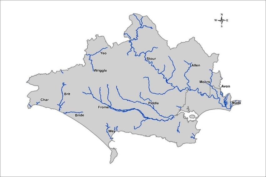
List of tables and figures

                                                                                                Page
 Map 1      The distribution of Strategic Nature Areas within the South-west                     6
 Map 2      Strategic Nature Areas in Dorset                                                     7

 Table 1    Priority Habitats in Dorset                                                          10

            Abbreviations: Organisations and Site status                                         37

                                          Acknowledgements

This document would not be feasible without considerable contributions from many individuals and
organisations during the past four decades. It is a summary document based upon the work of many.

The report has been produced and edited by DERC: Jon Corkill, Bryan Edwards, Rhiannon Rogers, Carolyn
Steele and Alison Stewart. We are especially grateful for contributions from: Annabel King, Andrew Brown,
Imogen Davenport, Stuart Roberts, Bill Shreeves, Chris Spilling, Philip Temple and Robin Walls.

                                                   -3-
Introduction

Welcome to the 2021 Dorset Biodiversity Audit.

This is the fourth Biodiversity Audit for Dorset and it is a great testament to the hard work of all who have
contributed, both through survey work, data collation, data analysis and report writing, that we now have
this series of documents to refer to.

An Audit is ‘a systematic and independent examination’ and this seems all the more necessary at the
moment given the recent changes within Dorset (with the formation of two Unitary Authorities from the
nine former Councils) and the far greater changes happening nationally and globally with the process of
leaving the European Union and the more recent Coronavirus pandemic. I know I’m not alone in placing
even greater value on our natural environment at the moment and it is very apparent how much we all rely
on the green and wild spaces around us, whatever happens on the national and international stage.

The Audit has been produced by the Dorset Environmental Records Centre whose work underpins just
about everything those of us involved in nature conservation do. DERC’s daily work of collating and
analysing baseline information enables us to monitor change and be confident about what is happening to
the habitats and species around us. Through this we can accurately assess how our natural environment is
responding to pressures including development, climate change, population increase and changes in
agricultural practice.

With change comes opportunity and there are some significant changes taking place in our legislative
framework. The draft Environment Bill brings together measures to ensure biodiversity is included from the
earliest point in any development project and strengthens the biodiversity duty on Local Planning
Authorities to ensure that they don’t just ‘have regard’ to biodiversity but have a duty to ‘further’
biodiversity through conserving and enhancing, taking this a crucial step beyond previous legislation. For
the first time the government has mandated that 10% net gain must be achieved for all development,
strengthening existing planning policy and, importantly, developing a metric to calculate this precisely and
help increase certainty that it will be delivered. We will also see Local Nature Recovery Strategies and
Nature Recovery Networks taking shape across the country, with Dorset’s work on these already underway.

The draft Agriculture Bill sets out how land managers will be expected to place wildlife at the heart of what
they do, enshrining the principle of ‘public money for public goods’ and widening the remit of land
management to include natural capital as well as biodiversity. The new Environmental Land Management
Scheme (ELMS) is being developed and the Dorset AONB Team is involved in tests and trials to inform
delivery. These changes present tremendous opportunities but at the same time reflect the ever-increasing
threats to our natural and semi-natural countryside.

It will not be possible to monitor and enforce these changes without excellent baseline data and the Dorset
Audit provides a vital source of this information, summarising the latest data on our natural and semi-
natural habitats. This time the Audit has been extended to include marine habitats. This reflects the huge
advances made in declaring marine conservation sites around the UK coastline in recent years, and our
increased awareness of the value of these habitats.

Previous Audits have highlighted great steps forward in recording statutory site boundaries and areas of
priority habitat. This Audit comes at a time when the focus is firmly on the next stage: how sites are
connected on a landscape scale, where opportunities exist to strengthen this network and to protect and
enhance strategically important areas. DERC has been instrumental in providing the data for our Dorset
Ecological Networks (existing and higher potential) maps to help ensure that we know and value what we

                                                     -4-
have and put all our efforts into conserving and enhancing areas which will provide the biggest gains for
wildlife. These in turn will be used to produce the first Local Nature Recovery Strategy for Dorset, as set
out in the draft Environment Bill, and put Dorset at the forefront of national change and progress.

Annabel King

Natural Environment Team Leader
Dorset Council

                                                     -5-
The Framework of the Audit
This Audit builds upon the work of the previous Dorset Biodiversity Audits. It is intended to set out clearly
and concisely where we have data. It also identifies where some of the gaps are. This is particularly
noticeable with habitat data, where we are currently unable to provide habitat maps. Some habitats, for
example all hedgerows and ponds, are widespread. Mapping all hedgerows and ponds across Dorset is a
huge undertaking and data is more likely to be acquired through smaller projects such as the Purbeck Pond
Project. The Dorset Biodiversity Audit provides an opportunity to bring together data gathered through
different organisations and present it as a summary for the county.
Habitat Accounts
The list of Priority Habitats has been changed and expanded since the last Audit. The data presented here is
the most current data available in DERC. We now have maps for more habitats including traditional
orchards, ponds and coastal floodplain grazing marsh.
Each habitat account includes:
• A Strategy reference – this refers to the relevant section in the Dorset Biodiversity Strategy
(Dorset Biodiversity Partnership, 2003)
• Distribution map of the habitat in Dorset;
• A selection of sites (with open access where possible);
• Key species – Priority Species associated with the habitat;
• Characteristic species – species commonly seen within the habitat.
A summary of Priority Habitats found in Dorset is included at the start of this section.
Marine habitat data is covered by a separate report.
Species List
The species list can be downloaded separately as an Excel file. It has been reviewed with comments from
county recorders and other local experts.
The Dorset Biodiversity Audit has been produced by DERC on the best available information. It is a
statement of the data held at DERC at the current time. This information will continue to be revised and
updated, but we believe that the data within this document is robust and will assist in decision-making.
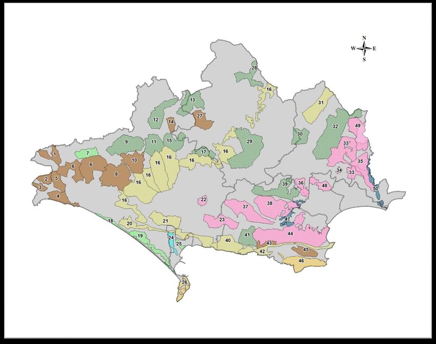
-6-Strategic Nature Areas
Within this report biodiversity has been presented by habitat and by species. However, it is also important
to consider wildlife, not just at a local scale, or even a county scale, but also at a landscape and regional
scale. The South West Regional Biodiversity Partnership did this through the development of the South
West Nature Map, by looking at the best areas in our region to conserve, create and connect habitats.
Nature Map was created in collaboration and consultation with many individuals and organisations. The
result was a regional map with landscape scale blocks of land, referred to as Strategic Nature Areas. Each
SNA will contain a mosaic of habitats, including areas of high biodiversity. Where previously attention may
have been concentrated on sites, Nature Map encourages a broader approach looking at opportunities for
restoration and re-creation of a range of habitats within these SNAs.
It is important to recognise that there is an abundance of biodiversity outside any designated area
(including SNAs). This is clearly shown on the maps in the Local Authority Accounts where Priority Habitats
are mapped both within and beyond the SNAs. But Nature Map does provide a focus for looking at
potential areas for work at a larger scale.
Map 1. The distribution of Strategic Nature Areas within the South-west
Nature Map was produced through Biodiversity South West, which is no longer active. However the Nature
Map was always intended to be a long term vision, with broad areas of opportunity mapped, to be refined
locally as local initiatives become active. The map can be viewed on-line on Biodiversity South West
website: www.biodiversitysouthwest.org.uk/.
-7-Map 2. Strategic Nature Areas in Dorset
Code SNA Name
1 Thorncombe 19 Fleet hinterland 37 Puddletown Road
2 Wyld Warren 20 South Dorset Ridge 38 Wareham Forest
3 Wootton Fitzpaine 21 Maiden Castle 39 Lytchett Matravers
4 Golden Cap 22 Puddletown Forest 40 Lulworth Chalk
5 Marshwood Vale 23 Winfrith-Warmwell 41 Lulworth Woodlands
6 Beaminster 24 Wey Valley-Radipole 42 Purbeck Ridge
7 Upper Axe Vales 25 Lodmoor 43 Povington Meadows
8 Kingcombe/Powerstock 26 Isle of Portland 44 Purbeck Heaths
9 Melbury 27 Deadmoor Common 45 Corfe Valley
10 Upper Frome 28 Duncliffe 46 Purbeck Limestone
11 Batcombe 29 Milton Abbas 47 Poole Harbour fringe
12 Sherborne 30 Chetterwood 48 Canford Heath
13 Stourton Caundle 31 Pentridge 49 Ringwood Forest
14 Ryewater Farm 32 Cranborne 50 Avon Valley
15 Glanvilles Wotton 33 East Dorset Heaths
16 Dorset Chalk 34 Ferndown Common
17 Melcombe Park 35 East Dorset Heaths - South
18 Cogden-Bexington 36 Upton Heath
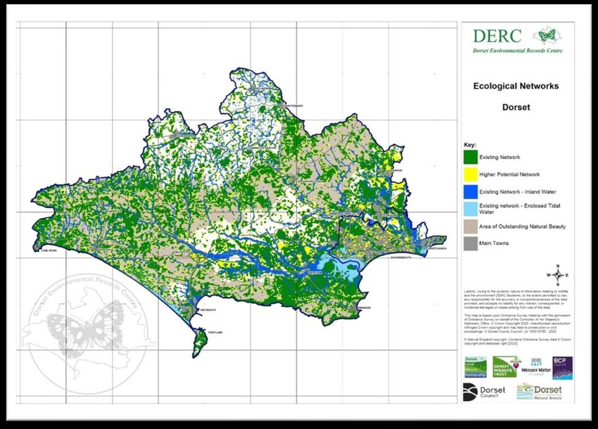
-8-Ecological Networks
Sites of wildlife importance in England have been lost or damaged at an alarming rate over the last 70
years. Those that remain are smaller and more isolated, and often in less favourable management regimes.
This has meant that wildlife species have in general declined, with only those species with very generalist
requirements and highly adaptable to our modified environments doing well.
In 2010, an independent review of England’s wildlife sites and ecological networks, chaired by Professor Sir
John Lawton, concluded unequivocally that England’s collection of wildlife areas does not represent a
coherent and resilient ecological network capable of responding to the challenges of climate change and
other pressures. The review made 24 recommendations but summarised what needed to be done in just
four words: more, bigger, better and joined. Government has adopted the suggested approach, and the
concept of an ecological network is now embedded in the National Planning Policy Framework (NPPF)
(2019), Natural Environment White Paper (2011) and Biodiversity 2020 (2011). Ecological networks are a
key tool for developing and a delivering a Nature Recovery Network as set out in the Government’s 25 Year
Environment Bill (2018), Nature Networks (NE Evidence Handbook 2020) and Local Nature Recovery Plans
(included in the Environment Bill (2020).
Priority Habitats such as those identified in the Dorset Biodiversity Audit form a crucial part of the
ecological network, alongside corridors and stepping stones of semi-natural habitat, sites under restoration
and areas of high potential for restoration or habitat creation. Dorset Local Nature Partnership has worked
with DERC and others to produce and update ecological network maps for Dorset, alongside guidance on
their use. Both are available on the Dorset LNP website1.
1
www.dorsetlnp.org.uk/dorsets-ecological-networks/
-9-Natural Capital and Ecosystem Services Mapping
Natural capital means “that part of nature which directly or indirectly underpins value to people, including
ecosystems, species, freshwater, soils, minerals, the air and oceans, as well as natural processes and
functions.” (Natural Capital Committee, 2019). In combination with other types of capital (financial, social
etc), natural capital forms part of our wealth; that is, our ability to produce actual or potential goods and
services into the future to support our wellbeing.
Natural capital provides a range of ‘ecosystem services’ including for example water quality, pollination,
flood alleviation, carbon sequestration and enjoyment and wellbeing, both mental and physical. Each
natural site or habitat can and usually does provide multiple benefits. Ecosystems services are often
grouped as follows:
• Supporting services, such as nutrient cycling, oxygen production and soil formation. These underpin
the provision of the other ‘service’ categories.
• Provisioning services, such as food, fibre, fuel and water.
• Regulating services, such as climate regulation, water purification and flood protection.
• Cultural services, such as education, recreation, and aesthetic value.
All of the habitats and species featured in the Dorset Biodiversity Audit are part of our natural capital. Both
nationally and locally there have been initiatives to map natural capital and ecosystem services – both
existing and potential. These make use of data such as that within this Audit, and take it a stage further by
assigning value, for example to map where natural habitats currently best provide these services, and
where they could provide this function if habitats are created or restored. Such initiatives are reliant on the
quality of the data which is used in terms of both accuracy and currency. Maintaining up to date baseline
information on habitat and species distribution and quality is crucial.
- 10 -HABITAT ACCOUNTS
Table 1. Priority Habitats in Dorset
All
Dorset DC BCP
2020 2020 2020
Priority Habitat Area(ha) Area(ha) Area(ha)
Coastal Floodplain & Grazing Marsh 655 460 195
Coastal saltmarsh 476 376 100
Coastal sand dunes 93 90 3
Coastal vegetated shingle 101 100 0
Lowland beech and yew 34 34 0
Lowland calcareous grassland 3286 3286 0
Lowland dry acid grassland 663 565 98
Lowland fens (excluding Valley mires) 47 45 2
Lowland fens (including Valley mires) 665 656 9
Lowland heathland 5529 4669 860
Lowland meadows 702 663 38
Lowland mixed deciduous woodland 4401 4288 112
Maritime cliff and slope 670 670 0
Ponds (of High Ecological Quality) 7 7 0
Purple moor grass 532 500 32
Reedbeds 289 272 18
Saline lagoons 511 511 0
Traditonal Orchards 67 67 0
Wet woodland 585 553 32
Wood pasture and parkland 590 590 0
The data presented here and in the following accounts is the most current data available in DERC. This
includes data from Wild Purbeck NIA heathland mapping in 2013 and ongoing SNCI surveys. New data
sources include the National Forest Inventory and more recent aerial photographs have helped improve
mapping, particularly for woodland sites.
There have been small changes in all areas compared with the previous Audit. Many of these are due to
improved habitat mapping rather than genuine changes on the ground, particularly for woodland. Others
reflect real change, such as the increase in the area of mapped heathland following clearance of conifers on
the Purbeck Heaths. We have also produced maps for traditional orchards, ponds and coastal floodplain
grazing marsh for the first time. Comments on changes are given under each habitat section.
- 11 -HABITAT ACCOUNTS
Lowland mixed deciduous woodland
Theme: Forestry & Woodland
Strategy reference: 2.2.1. This wide-ranging habitat includes all ancient semi-natural woodland and all semi-
natural recently established woodland comprising Ash, Birch, Maple and Oak, often over a well-developed
understorey of Hazel or Holly.
In Dorset Lowland mixed deciduous woodland consists mainly of small farm woodlands that have
traditionally been managed as coppice-with-standards. The main focus of woodland conservation effort in
the county is on ancient woodlands, since these are generally the richest in wildlife. The days in which ancient
deciduous woodland was converted to conifer plantations has now gone.
Site Name Grid Area of Status: organisation
Habitat
Brackett’s Coppice ST5107 20 ha SSSI: DWT
Garston Wood SU0019 34 ha SSSI: RSPB
Langton West Wood SY9979 17 ha SNCI: NT
Powerstock Common SY5496 60 ha SSSI: DWT
Key species
Dormouse
Bechstein’s Bat
White Admiral
Usnea articulata
Fly Orchid
- 12 -HABITAT ACCOUNTS
Lowland beech & yew woodland
Theme: Forestry & Woodland
Bluebell woods
Strategy reference: 2.2.3. These woodlands have a very restricted distribution in Dorset. Several small Yew
woodlands have developed on the scarp slope of the chalk in the north-east. Beech is on the western limit of
its native distribution in Dorset, but is an important constituent of two woodlands in the east of the county.
Old beech plantations that are not commercial woodlands and have developed a flora and fauna typical of
more ancient sites are also included.
Site Name Grid Area of Status: organisation
Habitat
Holt Forest SU0305 65 ha SSSI; NT
Hambledon Hill (Yew wood) ST8411 6.5 ha SSSI
Key species
Bird’s-nest Orchid
- 13 -HABITAT ACCOUNTS
Wet woodland
Theme: Forestry & Woodland
Strategy reference: 2.2.2. These woodlands have formed on seasonally or permanently water-logged soils,
and have a canopy often dominated by Alder, Downy Birch and Willow species. Two areas in the county are
particularly important; the floodplains of the larger rivers in the Poole Basin and springlines and seepages in
the northern and western vales. Wet woodland includes both ancient and more recent stands, both of which
are of high conservation importance. This habitat may be found in conjunction with fen and swamp.
Site Name Grid Area of Status: organisation
Habitat
Kingcombe Meadows NR SY5498 3 ha SSSI: DWT
Morden Bog SY9191 5 ha SSSI: NE
Studland NNR SZ0283 6 ha SSSI: NT
Troublefield SZ1297 0.5 ha SSSI: DWT
Key species Characteristic species
Marsh Tit Alder
Goat Moth Greater Tussock Sedge
Gyrodon lividus Opposite-leaved Golden-saxifrage
Mezereon Woodcock
Scarlet Elf Cup
- 14 -HABITAT ACCOUNTS
Wood-pasture and parkland
Strategy reference: 2.6. These habitats are relics of historic land management systems, and represent a
vegetation structure rather than being a particular plant community. Typically this structure consists of large
open-grown or high forest trees, often veterans, at various densities, in a matrix of grassland, heathland
and/or woodland vegetation. The presence of large old trees is a key characteristic of this habitat type, and
many plant, fungi and insect species are associated with, or dependent on, them. The processes which led to
the creation of these habitats have long since ceased and most of Dorset’s parklands have been converted
to farmland. However, the few remaining examples, such as Melbury Park, are of international importance.
Wood-pasture is particularly important for bats.
Veteran trees can also occur in other habitats such as hedgerows, but the extent of the resource is poorly
known. Wayside trees are typically found along roads and tracks or in improved pasture, sometimes as relics
of former 18th or 19th century landscaped parks. They are subject to natural eutrophication and support a
lichen flora of national importance.
Site Name Grid Area of Status: organisation
Habitat
Holt Forest NNR SU0305 65 ha SSSI, NT
The Oaks ST9603 8.5 ha SNCI, NT
Turnworth Common ST8108 36 ha SNCI, NT
Upton Country Park SY9992 4.5 ha LNR
Key species Characteristic species
Noctule Bats
Oak Polypore Bracket fungi
Anaptychia ciliaris Old woodland lichens
Enterographa sorediata Saproxylic (deadwood)
invertebrates
- 15 -HABITAT ACCOUNTS
Hedgerows
Theme: Agriculture
Strategy reference: 2.3.5. Hedgerows are an intimate element of the farmed landscape and are a refuge for
a wide variety of plants and animals. They act as wildlife corridors, providing protection and assisting
dispersal of species in an otherwise fragmented landscape. Ancient hedgerows, which tend to be those that
support the greatest diversity of plants and animals, may be identified as those that were in existence before
the Enclosures Act were passed (mainly between 1720 and 1840).
As a region, the south-west probably has a greater number of hedges remaining than any other region in the
UK. In Dorset, the west of the county in particular holds the highest concentration of this habitat.
Site Name Grid/location Status: organisation
Blackmore Vale West Dorset
Kingcombe Meadows NR SY59 SSSI: DWT
Marshwood Vale West Dorset
This habitat has not been mapped for Dorset.
Key species Characteristic species
Yellowhammer Hedge brown
Dormouse Whitethroat
Brown Hairstreak Red Campion
Copse Bindweed Bank Vole
- 16 -HABITAT ACCOUNTS
Traditional orchards
Theme: Agriculture
Traditional orchards were added to the UK Priority Habitat list in 2007. The Mid Term Review of the Strategy
incorporates actions for this habitat; these can be found in the Forestry and Woodland Management section
(actions FWM20 – FWM23). Dorset has relatively few traditional orchards compared with other counties in
the south-west, notably Somerset. The vast majority that are present are very small and found close to manor
houses or farmhouses. Most of the larger intensively managed orchards that are part of the landscape are of
relatively recent origin and therefore do not strictly fall within the definition of the habitat.
Although covering a relatively small area, orchards can include a number of other habitat types including
hedgerows and species-rich grassland that add significantly to the interest. Older trees can have the features
of ‘veteran trees’ such as dead wood, bracket fungi and rot holes. A wide variety of epiphytic bryophytes and
lichens have been found on old fruit trees. Traditional orchards can support types of fruit tree that are now
rare and of considerable genetic and historic importance.
Site Name Grid Area of Status: organisation
Habitat
Broad Oak Community Orchard ST7912 0.2 ha DWT
King’s Lane Community Orchard ST5196 0.3 ha DWT
The map is based on a data set
available from Natural England
checked against aerial
photographs and other data
available at DERC.
- 17 -HABITAT ACCOUNTS
Arable field margins
Theme: Agriculture
Strategy reference: 2.3.6. The UK Priority Habitat of arable field margins has been broadened for the context
of Dorset, to include the whole arable field where it is utilised by key species. In 2016 Arable land (97,946 ha)
covered approximately 37% of the county. Biodiversity on arable land has come under intense pressure due
to intensification and specialisation of arable production.
There is little quantitative data for biodiversity-rich land in Dorset. There is however, much evidence of
massive declines in plant species indicative of arable land and of widespread declines in populations of
farmland birds. In Dorset the Tree Sparrow has been lost as a breeding species, and others such as Grey
Partridge and Corn Bunting are increasingly rare in the county. ‘Hotspots’ for arable biodiversity occur on the
chalk in north-east Dorset and the limestone in Purbeck.
Site Name Grid Status: organisation
St Aldhelm’s Head SY97 SNCI
Portland Bill SY66
This habitat has not been mapped for Dorset.
Key species
Corn Bunting Characteristic species
Brown Hare Skylark
Shepherd’s Needle Yellowhammer
Pheasant’s-eye Poppy
- 18 -HABITAT ACCOUNTS
Lowland meadows
Theme: Agriculture
Strategy reference: 2.3.1. Neutral grasslands occur on a range of soils usually with a pH of between 4.5 and
6.5. It includes enclosed dry hay meadows and pastures. These are confined to two main areas in Dorset, the
northern and western vales, and the clays around the periphery of the heaths in the Poole Basin. Across the
UK 97% of this habitat has been lost between 1930 and 1984, making it one of the most endangered in Britain.
In Dorset, many of these areas comprise a mosaic of dry grassland and rush-pasture, and are often small and
isolated. The Dorset Neutral Grassland Inventory (DERC 2002b) identified 241 sites. The few larger examples
such as the Golden Cap Estate and Kingcombe Meadows are of national importance. Most are managed as
grazed pasture, with a few still traditionally cut for hay.
Site Name Grid Area of Status: organisation
Habitat
Corfe Mullen Meadow SY9896 1.6 ha SSSI: DWT
Golden Cap Estate SY3892 40 ha SSSI: NT
Kingcombe Meadows SY5498 75 ha SNCI: DWT
Ryewater Farm meadows ST5106 12 ha SSSI: DWT
Key species Characteristic species
Skylark Crested Dog’s-tail
Grizzled Skipper Common Knapweed
Green-winged Orchid Oxeye Daisy
Meadow Grasshopper
Marbled White
- 19 -HABITAT ACCOUNTS
Lowland calcareous grassland
Theme: Agriculture
Strategy reference: 2.3.3. Calcareous grassland occurs on chalk and limestone substrates. Dorset’s chalk
grassland supports an outstanding range of flora and fauna across an area of just under 3000 ha (DERC, 1998).
This habitat is very fragmented and mainly confined to the steeper scarp slopes of chalk outcrop. The majority
of grassland has been recognised to be either of national or countywide importance.
Limestone grassland is much more limited in extent, and equally fragmented; with the majority on the Isle of
Portland or the Purbeck Coast, with a few outlying sites in the north and west. The Dorset Limestone
Grassland Inventory (DERC& DWT, 2000) identified 480 ha in the county. The vast majority is recognised as
being of national importance and within various SSSIs, with the remainder selected as SNCI. The limestone
turf supports many key plant species, and a similar range of butterflies that occur on the chalk.
Site Name Grid Area Status: organisation
Badbury Rings ST9603 36 ha SSSI: NT
Fontmell and Melbury Downs ST8818 211 ha SSSI: NT/DWT
Hog Cliff NNR SY6197 47 ha SSSI, NNR: NE
Durlston Country Park SZ0277 22 ha SSSI, NNR: DCC
Key species Characteristic species:
Early Gentian Cowslip
Blackwort Adonis Blue
Lulworth Skipper
Marsh Fritillary
Chalk Carpet
- 20 -Early Gentian
HABITAT ACCOUNTS
Lowland dry acid grassland
Theme: Agriculture
Strategy reference: 2.3.4. Lowland acid grassland typically occurs on nutrient-poor, free-draining soils with a
pH ranging from 4-5.5 overlying sands and gravels. In Dorset this habitat is largely confined to two distinct
areas: the Poole Basin and periphery of the heaths, and west Dorset where they are associated with the
Greensand, especially on acid hill tops. Dorset supports approximately 500 ha of dry acid grassland (DERC,
2002). The parched sandy grasslands of the Poole Basin are of national importance for their acid grassland
plants, while some of those in the west are rich in grassland fungi.
Acid grassland is normally managed through grazing by livestock or rabbits, on some sites it is maintained by
mowing (often along with rabbit grazing). However, some of the richest sites have developed naturally on
former arable land and periodic disturbance is an additional important factor in maintaining the rich flora.
Site Name Grid Area of Status: organisation
Habitat
Corfe Common SY98 40 ha SSSI: NT
Golden Cap Estate SY4092 10.5 ha SSSI: NT
Hengistbury Head SZ1690 9.5 ha SNCI, LNR
Kingcombe Meadows SY5498 11.8 ha SSSI: DWT
Key species Characteristic species:
Hornet Robber Fly Waxcap fungi
Small Heath
Chamomile
Glandular Eyebright
- 21 -HABITAT ACCOUNTS
Lowland heathland
Strategy reference: 2.7. Lowland heathland is dominated by dwarf ericoid shrubs (heathers) along with
species of Gorse on poor soils, typically sands and gravels. It is rare within a European context making the
Dorset heaths one of our most important habitats. Historically the loss and fragmentation of the heaths has
been attributable to agriculture, forestry and urban development. Until recently lack of management
compounded the situation.
As well as being a distinctive habitat, heathland can also be described as a working landscape of open land,
mires, trackways, drinking ponds, small quarries, sandy grassland and pasture woodland. The loss of this
traditionally managed landscape has led to a significant decline in so called ‘heathland’ species.
Site Name Grid Area of Status: organisation
Habitat
Hartland Moor SY9585 172 ha SSSI; NE/NT
Avon Heath CP SU1303 52 ha SSSI: DCC/RSPB
Upton Heath SY9894 77 ha SNCI: DWT
Winfrith Heath SY8087 71 ha SSSI: DWT
Key species Characteristic species Heathland is one of the few habitats
Nightjar Ling showing an apparent increase in habitat
Silver Studded Blue Bell Heather area. Most of this ‘new’ heathland has been
Heath Bee-fly Dwarf Gorse created by the felling of conifer plantations
Marsh Clubmoss Grayling around Rempstone Heath, restoring part of
Smooth Snake Dartford Warbler the original Dorset Heaths.
Tiger Beetle
- 22 -HABITAT ACCOUNTS
Purple moor-grass & rush-pasture
Theme: Agriculture
Strategy reference: 2.3.2 Purple Moor-grass and rush-pasture sites exist on poorly drained, nutrient-poor
soils. They consist of mosaics of different communities that can include species-rich fen-meadows, wet
heaths and mire, as well as drier grassland and scrub.
Purple Moor Grass is a species-rich vegetation type developed on nutrient-poor but base-rich or flushed soils.
In Dorset the stands are small and fragmented, and largely confined to the periphery of the heaths and the
western vales.
Rush-pasture is the most common vegetation type in poorly drained pastures. Soft and Sharp-flowered Rush
dominate, and when grazed a wide variety of herbs are present. This habitat type is much more widespread
than Purple Moor Grass.
Site Name Grid Area of Status: organisation
Habitat
Corfe Common SY9581 16 ha SSSI: NT
Kingcombe Meadows SY5498 13 ha SSSI: DWT
Powerstock Common SY5497 7.5 ha SNCI: DWT
Tadnoll Meadows SY7987 11.5 ha SSSI: DWT
Key species Characteristic species
Marsh Fritillary Purple Moor-grass
Viper’s Grass Sharp-flowered Rush
Meadow Thistle
Mint Leaf-beetle
- 23 -HABITAT ACCOUNTS
Coastal and floodplain grazing marsh
Theme: Freshwater
Strategy reference: 2.4.1. Coastal and floodplain grazing marsh is defined as wet grassland that has
been formed by the claiming of coastal or floodplain wetland. Areas may have been enclosed by sea
walls or river banks. They are poorly drained by tidal channels or by an interconnected grid of ditches
that are typically subject to locked drainage through tidal or fluvial influences. Their fertile soils
support intensive farmland and there is a marked contrast between seasons. In winter, the flooded
fields are home to wading birds and waterfowl, whilst in the summer, the wildlife interest is largely
confined to the water-filled ditches which can be rich in plants and invertebrates.
Historically Dorset contained about 5,300 ha of lowland wet grassland. Since about 1900
approximately 200 ha (12%) of the county’s grazing marsh has been destroyed through loss of the
tidal channels or ditch network through development, waste disposal or re-flooding. Parts of the
remaining area have changed from grassland to reed or sedge swamp. In coming years some grazing
marsh around the harbours will be vulnerable to loss from rising sea levels and the unsustainable
nature of sea walls. Managing such a complex system is a delicate balance and needs to consider
soil, water, wildlife and farming.
Site Name Grid Area of Status: organisation
Habitat
Wareham Common SY9187 4.2 ha SSSI
West Bexington - Cogden SY5286 10 ha SSSI; NT / DWT
Winkton Common SZ1594 14 ha SSSI
Key species Characteristic species
Tubular Water Dropwort Snipe
Lapwing Hairy Dragonfly
Desmoulin's Whorl Snail Lesser Marsh Grasshopper
European Eel - 24 -
OtterHABITAT ACCOUNTS
Lowland fens
Theme: Freshwater
Strategy reference: 2.4.4. Fens are formed over peaty soils that receive calcareous groundwater and they can
occur in floodplains, around seepages and along springlines.
Fens are rare in Dorset with the 45 ha found within existing SSSIs and SNCIs accounting for the majority of
the county’s resource. Individual fens are small and scattered and usually occur within or on the periphery
of other habitats of nature conservation value, including heathland, rush-pasture and wet woodland. Many
of the fens within the larger heathland complexes can be accommodated within the management of the
larger site. Other fens exist in river valleys and are an important element for consideration in river
management strategies. A few important habitats remain within the agricultural landscape where
Marsh Marigolds in grazing marsh
conservation effort needs to be specifically targeted.
Site Name Grid Area Status: organisation
Corfe Common SY9581HABITAT ACCOUNTS
Lowland fens – valley mires
Theme: Freshwater
Strategy reference: 2.7. Valley mires are formed where peat accumulates and there is a permanently high
water table, allowing the formation of Sphagnum moss, and are typically fed by acid ground water. The
habitat is rare at a European level and in the UK the New Forest and Dorset heaths support the vast majority
of the resource. Many rare and uncommon plant and invertebrate species are associated with valley mires.
In Dorset the vast majority of the resource is found within heathland complexes in the Poole Basin, and recent
grazing initiatives have also benefited the mire systems.
Site Name Grid Area of Status: organisation
Habitat
Hartland Moor SY9585 58 ha SSSI:NE/ NT
Morden Bog SY9190 102 ha SSSI: NE
Slop Bog SU0701 2.1 ha SNCI; DCC, LNR
Studland and Godlingston Heaths SZ0183 35 ha SSSI: NT
Key species Characteristic species
Southern Damselfly Sphagnum moss
Large Marsh Grasshopper Cottongrass
Great Sundew Bog Asphodel
Chrysops sepulchralis Small Red Damselfly
Bog Bush-cricket
- 26 -HABITAT ACCOUNTS
Reedbeds
Theme: Freshwater
Strategy reference: 2.4.3. Reedbeds are wetlands dominated by, but not necessarily, composed purely of,
stands of common reed Phragmites australis. It includes areas of reeds that are both in freshwater and
brackish water habitats.
Nationally, reedbeds are a rare habitat, and this is reflected in Dorset. But despite its scarcity Dorset’s
reedbeds are important for many scarce invertebrates, and several uncommon birds.
Ownership of reedbeds is largely sympathetic the conservation of this habitat in Dorset.
Site Name Grid Area of Status: organisation
Habitat
Abbotsbury Swannery SY5784 15 ha SSSI
Burton Mere - Cogden SY5087 4 ha SSSI: NT
Poole Harbour reedbeds SY9587 183 ha SSSI: RSPB / NT
Radipole Lake SY6780 45 ha SSSI: RSPB
Key species Characteristic species
Water Vole Common Reed
Reed Leopard
Bittern
Reed Bunting
- 27 -HABITAT ACCOUNTS
Rivers
Theme: Freshwater
Strategy reference: 2.4.2. In the 2003 Dorset Biodiversity Strategy and Audit only chalk streams were
included, but the habitat definition was subsequently widened to include all rivers on all substrates. This
wider habitat is reflected in the Mid Term Review of the Strategy under the Freshwater Management section
(actions F1 – F13)
Dorset supports a significant amount of the national resource of chalk streams, plus other very important
rivers such as the Stour, Moors, the lower reaches of the Avon and parts of the Axe in the far west. This
variety is reflected in the rich associated riparian flora and invertebrate fauna. Dorset rivers are also
important for migratory fish such as Eel, Salmon and Sea Trout. Fish are prey to the Otter which is currently
on the increase. White-clawed Crayfish only survive in a very few sites.
As with all wetland habitats rivers are vulnerable to pollution and run-off from adjacent land use, and to low
water flows through abstraction.
Site Name Status: organisation
River Avon SSSI, SAC
River Frome SSSI
Moors River SSSI
River Stour
Characteristic species: Key species:
Stream Water-crowfoot Otter
Yellow Water-lily Water Vole
Banded Demoiselle River Lamprey
Brown Trout Sea Lamprey
Salmon
Sharp’s Diving Beetle
- 28 -HABITAT ACCOUNTS
Ponds
Theme: Freshwater
Strategy reference: 2.3.7. In the more recent Dorset Biodiversity Strategy Mid Term Review, ponds have been
moved to the Freshwater Management section (actions F23 – F27). Ponds are defined as small permanent or
semi-permanent water bodies between 25 m2 and 2 ha in area. They provide valuable refuges for wildlife in
the wide countryside for many forms of wildlife, especially amphibians and wetland invertebrates. Due to a
combination of agricultural intensification, pollution, development and lack of management the number of
ponds and their quality has declined throughout the UK, and in Dorset the true extent of the resource is as
yet unknown.
The ponds that qualify as the Priority Habitat are those that support invertebrate or plant species of national
or international importance or are particularly species-rich based on strict criteria.
Site Name Grid Status: organisation
Powerstock Common SY537968 SSSI: DWT
Key species:
Great Crested Newt
Common Frog
Pillwort
Downy Emerald
Old clay pit, Creech Heath
- 29 -HABITAT ACCOUNTS
Oligotrophic and mesotrophic lakes
Theme: Freshwater
Dorset has very few semi-natural large standing water bodies except Little Sea. This site is important in a
national context, supporting uncommon plant species and are also important for wintering waterfowl. There
are more man-made water bodies resulting from mineral abstraction and the older ones, particularly ball
clay pits in Purbeck, can support a wide variety of wildlife and are especially important for dragonflies. Most
large water bodies are included within SSSIs or SNCIs.
Site Name Grid Area of Status: organisation
habitat
Little Sea SZ0284 31 ha SSSI, SAC: NT
Key species Characteristic species:
Six-stammened Waterwort Ruddy Darter
Spring Quillwort
- 30 -HABITAT ACCOUNTS
Open mosaic habitats on previously developed land
A wide ranging habitat type encompassing land that has previously been developed, mined or quarried for
minerals, but has been abandoned and has developed an interesting range of wildlife.
Some sites, especially old gravel working, will have been flooded and now support species associated with
wetlands and can be important for wintering and breeding waterfowl and for dragonflies. Other sites are
partially vegetated with large amounts of bare ground and exposed faces that provide a habitat for a wide
variety of invertebrates.
The vast majority of this habitat is found in the south-east of the county and is associated with extraction of
sand and gravel within the wider heathland landscape. Portland and Purbeck have a number of abandoned
limestone quarries. Within the urban area brown field sites are generally rare due to the pressure for
development.
Site Name Status: organisation
Arne Clay Pit / Bestwall Quarry RSPB
Portland quarries including Broadcroft Quarry and SSSI: DWT
Tout Quarry
This habitat has not been mapped for Dorset.
- 31 -HABITAT ACCOUNTS Maritime cliff and slope Theme: Coastal Strategy reference: 2.5.1. Dorset’s coastline comprises soft and hard cliffs and undercliffs, and vary greatly between massive vegetated land slips, high chalk cliffs and pinnacles, unstable shales and sand and sheer limestone faces and ledges. The habitats that develop on the cliffs and slopes are varied, and are some of the most natural anywhere in the county. On soft cliffs in particular there is high proportion of bare ground, compared with other habitats, which is utilised by many specialised plant and invertebrate species. Other habitats include maritime grassland, flushes, scree and scrub. The Dorset resource includes: 54.48 km soft cliffs 33.81 km hard cliffs 10.24 km are composite sites (with soft undercliffs backed by hard, sheer limestone cliffs) Total recorded length is 78.05 km Much of the coast is within the East Devon and Dorset World Heritage Site and shows a complete section through the Upper Jurassic rocks. Site Name Status: organisation Purbeck Coast (limestone) SSSI: NT/DCC Isle of Portland (limestone) SSSI: White Nothe – Lulworth Cove (chalk) SSSI: Eype – Lyme Regis (sands and clays) SSSI: NT Key species Characteristic species Cliff Tiger Beetle Wild Cabbage Long-horned Bee Colt’s-foot Dorset Clothes moth Solitary Wasp & Bees Odynerus melanocephalus Rock Pipit Triangular Pygmy-moss Adder - 32 -
HABITAT ACCOUNTS

Coastal vegetated shingle

Theme: Coastal
Strategy reference: 2.5.1. Shingle is defined as sediment with particle sizes in the range 2-200 mm. It is a
globally restricted sediment type with few occurrences outside north-west Europe, Japan and New Zealand.

Coastal vegetated shingle occurs widely around England’s coast, however, large shingle beaches where areas
of shingle become stabilised and support vegetation are relatively few. Chesil Beach is one such structure. It
is an internationally important breeding ground for Little Tern, and supports a specialised flora and fauna.
Very small areas of vegetated shingle also occur in Poole Harbour.

 Site Name                                 Grid               Status: organisation
 Chesil Beach                              SY49-67            SSSI

  Key species                                Characteristic species
  Little Tern                                Sea Kale
  Scaly Cricket                              Yellow Horned-poppy
                                             Sea Pea
                                             Ringed Plover

                                                     - 33 -
HABITAT ACCOUNTS
Coastal sand dunes
Theme: Coastal
Strategy reference: 2.5.1. Sand dunes are entirely a coastal phenomenon in Dorset. They comprise
windblown sand formations that are both stable and shifting and their associated slacks, grassland and scrub.
The only significant sand dunes in Dorset occur at Studland in Purbeck, which comprise approximately 90 ha
of dunes. This is the largest acidic dune system on the south coast and supports a large area of dune-heath,
and is also the only dune system in south central England to support any dune wetland (i.e. open water, mire,
swamp, wet heath and wet woodland).
The habitats importance for invertebrates, reptiles and vegetation is reflected in its designation as a National
Nature Reserve and Special Area of Conservation. Relic dunes also occur at Sandbanks, Hengistbury and
Mudeford. Blown sand is present amongst the shingle at Ferrybridge resulting in a very rich flora with many
sand dune specialists present.
Site Name Status: organisation
Studland NNR SSSI: NT
Hengistbury Head SSSI: LNR
Ferrybridge SSSI
Key species Characteristic species
Heath Tiger Beetle Marram Grass
Sand Lizard Sand Sedge
Prickly Saltwort Sea Bindweed
Sand wasp
Mottled Grasshopper
- 34 -HABITAT ACCOUNTS
Coastal saltmarsh
Theme: Coastal
Strategy reference: 2.5.1. Coastal saltmarshes comprise the upper, vegetated parts of intertidal mudflats,
lying approximately between high water neap tides and mean high water spring tides. Salt-marshes are
restricted to sheltered locations in estuaries, and the development of salt-marsh vegetation is dependent on
the presence of intertidal mudflats. They are an important resource for wading birds and wildfowl.
In Dorset by far the largest area of salt-marsh is found around Poole Harbour, with small stands present by
the Fleet, at Lodmoor and in Christchurch Harbour. Dorset has suffered less from salt-marsh reclamation
than other southern counties, and the upper salt-marsh zone with transitions to grassland, heathland, mire,
reedbed and woodland is well represented.
Site Name Status: organisation
Christchurch Harbour SSSI, LNR
Ferrybridge & Fleet SSSI
Lodmoor SSSI: RSPB
Poole Harbour SSSI
Characteristic species
Common Cord-grass
Common Sea-lavender
Sea Aster
Lesser Marsh Grasshopper
- 35 -HABITAT ACCOUNTS
Saline lagoons
Theme: Coastal
Strategy reference: 2.5.2. Saline lagoons are natural or artificial bodies of saline water wholly or partially
separated from the adjacent sea. They retain a proportion of their seawater at low tide and may develop as
brackish, fully saline or hyper-saline water bodies.
The Fleet is the largest saline lagoon in Britain, and in terms of its biodiversity one of the most important in
Atlantic Europe. Seawater exchange is mainly through a single, small inlet, and secondarily by percolation
through the Chesil Bank, the enclosing barrier. Low freshwater input results in near fully saline conditions
through most of the lagoon. Tidal rapids within the outer lagoon support rich seaweed and sponge
assemblages, and there are important Zostera and Ruppia beds within the lagoonal basin. More than 750
aquatic plant and animal species have been recorded within the Fleet over the past 35 years.
Site Name Grid Area Status: organisation
The Fleet SY58-67 480 ha SSSI
Key species Characteristic species
Foxtail Stonewort Eel-grass
Lagoon Sand-shrimp
Dark-bellied Brent Goose
- 36 -Glossary
Ancient Woodland – semi-natural woodlands which have been in existence since at least the Middle Ages.
The Fleet
Biodiversity – the variety of life on Earth.
Biodiversity Action Plan – a plan setting out the current status, issues and threats for a species or habitat,
and a programme of specific and timed actions with identified responsible agencies to restore, maintain or
enhance the biodiversity interest.
Convention on the Conservation of European Wildlife and Natural Habitats (Bern) – this imposes
obligations to conserve wild plants, birds and other animals, with particular emphasis on endangered and
vulnerable species and their habitats. The provisions of the Convention underlie the EC Habitats Directive
as well as the UK’s wildlife legislation.
EC Habitats and Species Directive (92/43/EEC) – this Directive requires Member States to take measures to
maintain or restore natural habitats and wild species at a favourable conservation status in the Community,
giving effect to both site and species protection objectives.
Habitat – the place in which a species of animal or plant lives, providing a particular set of environmental
conditions. Often used in a wider sense, referring to major assemblages or communities of plants and
animals found together.
Habitat Action Plan – a plan setting out the current status, issues and threats for a habitat, and a
programme of specific and timed actions with identified responsible agencies to restore, maintain or
enhance the biodiversity interest.
International importance – those species which the UK, at least at some time of the year, holds a high
proportion of the European or World population. For waterfowl, a site is defined as being internationally
important if it regularly supports over 20,000 waterfowl, or 1% of the biogeographical population of the
species. Habitat types and/or species which are rare or threatened within a European context are identified
in Annex I and II of EC Directive 92/43 on the conservation of natural habitats and of wild fauna and flora,
for which the Directive requires the designation of Special Areas of Conservation (SACs).
Invertebrates - animals without a backbone.
JNCC – Joint Nature Conservation Committee
National importance – a site is defined as being nationally important if it regularly supports over 1% of the
UK population of a species. This criterion is most usually applied to bird populations.
National Nature Reserve (NNR) – a site of national or international importance for conservation which are
primarily used and managed for nature conservation. NNRs are designated by Natural England and are the
best examples of their kind.
Nationally Scarce – invertebrates found in 16-100 10km squares nationwide.
Priority Habitats have been selected because they fulfil one or more of the following criteria: the habitat is
at risk; the UK has international obligations to protect it; they are functionally important for species
inhabiting wider environments; and/or they are important for species of particular conservation concern. In
- 37 -addition to the 36 UK Priority Habitats that occur in Dorset, the Dorset Biodiversity Partnership has added 4
habitats of local significance. Find out more at https://jncc.gov.uk/our-work/uk-bap-priority-habitats/
Priority Species - since 1995 the UK has listed its most threatened species. Find out more at
https://jncc.gov.uk/our-work/uk-bap-priority-species/
Protected species – species specially protected by the law, primarily under Schedules 1 (birds), 5
(amphibians, reptiles & mammals), and 8 (plants) of the Wildlife and Countryside Act 1981.
Ramsar – a site designated under the Ramsar Convention on the Conservation of Wetlands of International
Importance.
Red Data Book (RDB) species – catalogues published by the IUCN or by National Authorities listing species
which are rare or in danger of becoming extinct globally or nationally. Sometimes species are included for
which the national authority hosts a large part of the world’s population, and has an international
responsibility to conserve them.
Semi-natural habitats – habitats or communities that have been modified to a limited extent by man, but
still consist of species naturally occurring in the area.
Site of Nature Conservation Interest (SNCI) – sites selected for their habitat or species interest. Sites are
selected by an SNCI Panel with representatives of Dorset Wildlife Trust, Dorset Environmental Records
Centre, Natural England and Dorset County Council.
Special Area of Conservation (SAC) – a site designated under EC Directive 92/43 on the conservation of
natural habitats and wild fauna and flora.
Special Protection Area (SPA) – a site designated under Article 4 of EC Directive 79/409 on the
conservation of wild birds. Together SACs and SPAs form a network of European sites known as ‘Natura
2000’.
Site of Community Importance (SCI) – SAC adopted by the European Commission but not yet formally
designated by the Government.
Site of Special Scientific Interest (SSSI) – an area of land notified under the Wildlife & Countryside Act 1981
for their special scientific interest. They are the best examples of our natural heritage of wildlife habitats,
geological features and land forms. All sites of national and international importance on land are notified as
SSSIs. SSSIs are notified in England by Natural England.
UK endemic species – species that are confined to the UK and which, as far as is known, originated here.
Vascular plants – plants that contain vessels for conducting liquids – a vascular system. This includes
flowering plants, conifers, ferns and their allies.
Vertebrates – animals with a backbone; mammals, birds, reptiles, amphibians and fish.
World Heritage Site – an area considered to be of outstanding universal value, that meets one or more of
the four criteria set out by the United Nations Educational, Scientific and Cultural Organization (UNESCO).
- 38 -Abbreviations
Organisations
DC Dorset Council
BCP Bournemouth, Christchurch and Poole Council
DWT Dorset Wildlife Trust
NE Natural England
NT National Trust
RSPB Royal Society for the Protection of Birds
Site status
LNR Local Nature Reserve
NNR National Nature Reserve
SAC Special Area of Conservation
SAC (SCI) Special Area of Conservation (Site of Community Importance)
SNA Strategic Nature Area
SNCI Site of Nature Conservation Interest
SPA Special Protection Area
SSSI Site of Special Scientific Interest. In the habitat accounts these are linked to the site
manager e.g. Natural England, National Trust, RSPB etc.
- 39 -You can also read


