Assessing Vegetation Heritage Value: The Alentejo Central (Portugal) as a Case Study
←
→
Page content transcription
If your browser does not render page correctly, please read the page content below
Article

Assessing Vegetation Heritage Value: The Alentejo Central
(Portugal) as a Case Study
Teresa Batista 1,*, Jose Manuel de Mascarenhas 2, Paula Mendes 3 and Carlos Pinto-Gomes 4

                                         1 MED—Mediterranean Institute for Agriculture, Environment and Development, Institute for Advanced
                                           Studies and Research, University of Évora, Pólo da Mitra, Ap. 94, 7006-554 Évora, Portugal
                                         2 CIDEHUS—Interdisciplinary Centre for History, Culture and Societies of University of Évora, Palácio of

                                           Vimioso, Largo do Marquês de Marialva, n.º 8, Apartado 94, 7000-809 Évora, Portugal;
                                           mascarenhas_jm@outlook.pt or cidehus@uevora.pt
                                         3 Institute for Nature Conservation and Forestry, Regional Direction of Alentejo. R. Tenente Raul de Andrade,

                                           1 e 3, 7000-613 Évora, Portugal; paula.mendes@icnf.pt
                                         4 MED—Mediterranean Institute for Agriculture, Environment and Development & Department of

                                           Landscape, Environment and Land Planning, University of Évora & Institute of Earth Sciences (ICT), School
                                           of Science and Technology, University of Évora, Rua Romão Ramalho, nº 59, 7000-671 Évora, Portugal;
                                           cpgomes@uevora.pt
                                         * Correspondence: mtfb@uevora.pt

                                         Abstract: Vegetation natural heritage can be valued in itself, but also as a habitat for many wildlife
                                         species. This study presents a methodological essay concerning the evaluation of plant heritage,
                                         applied in Central Alentejo, in the south of Portugal. This evaluation was based on the following
                                         criteria: horizontal and vertical structure of vegetation, tree cover density, rare plant species rich-
                                         ness, phytocenotic maturity, importance as ecological corridor, historical record, scientific and edu-
                                         cational potential and recreational potential. The vegetation heritage value (VHV) was calculated
Citation: Batista, T.;
                                         using a linear combination of the weighted criteria. In this way it was possible to identify the most
de Mascarenhas, J.; Mendes, P.;
                                         interesting areas for conservation purposes. Of the 7500 km2 analyzed, 52% are natural and semi-
Pinto-Gomes, C. Assessing
                                         natural areas, and of these, 18.8% have very high VHV, 70.7% have high VHV and only 10.5% av-
Vegetation Heritage Value: The
                                         erage VHV. The highest VHV areas are actually included under the protected areas of Natura 2000
Alentejo Central (Portugal) as a Case
Study. Land 2021, 10, 307.
                                         sites.
https://doi.org/
10.3390/land10030307                     Keywords: vegetation heritage value; estimation methodology; landscape heritage; landscape
                                         ecology and planning; Southern Portugal
Academic Editor: Robert Baldwin

Received: 19 January 2021
Accepted: 6 March 2021                   1. Introduction
Published: 17 March 2021
                                              In the general concept of heritage, the emphasis on inherited goods and their conser-
                                         vation is important, generally encompassing elements, places and practices that have
Publisher’s Note: MDPI stays neu-
                                         meaning in the present and that relate to the past. In the classification of heritage, it is
tral with regard to jurisdictional
claims in published maps and insti-
                                         common to make a distinction between cultural heritage [1] and natural heritage [2,3].
tutional affiliations.                   The first concept involves man-made artifacts and other aspects related to "culture", some
                                         of which are of an intangible nature; the second one, concerns elements not manufactured
                                         by humans. However, in practice, heritage is a very complex concept, in which the two
                                         components, cultural and natural, are closely linked [4], with many of its values being of
Copyright: © 2021 by the authors.        a bio-cultural nature, translating an interpenetration between the two domains. In relation
Licensee MDPI, Basel, Switzerland.       to the natural heritage, it must be approached as a gift of nature, being composed of biotic
This article is an open access article   and abiotic natural elements. Concerning its intrinsic aspects, it is mainly valued for its
distributed under the terms and con-     contribution to ecological, biological and geological processes and the relative importance
ditions of the Creative Commons At-      of natural habitats for the conservation of biodiversity.
tribution (CC BY) license (http://cre-        The extension of the concept of heritage to the natural environment occurred since at
ativecommons.org/licenses/by/4.0/).      least the middle of last century. The acceptance of this extension at the international level

Land 2021, 10, 307. https://doi.org/10.3390/land10030307                                                                 www.mdpi.com/journal/land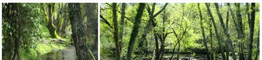
Land 2021, 10, 307 2 of 17
took place mainly following the Convention for the Protection of the World Cultural and
Natural Heritage [3], adopted by the General Conference of UNESCO on 16 November
1972. It was then considered that the natural heritage included relevant biotic and abiotic
elements as well as natural sites.
This was an important step in the concept of heritage which should not only be char-
acterized, but also monitored and managed in everyday life, becoming recognized in its
living and evolutionary aspect [5].
Although that Convention has been subject to periodic reviews since its first edition,
a more integrated approach to natural and cultural heritage has not been envisaged so far.
The fact that in Article 2 of the Convention, which addresses the natural heritage, there is
no mention of combinations of natural and cultural elements, or of the interaction between
Man and the Environment [6], led many countries to create ‘separate policies for natural
and cultural heritage conservation, including different administrations that apply differ-
ent legislation, methods, languages, scientific disciplines, and practices’ [7].This does not
invalidate the option in this paper by conducting a methodological development essay to
estimate the natural heritage, addressing this per se and in an intrinsic way, which is con-
sidered of interest in the framework of the management of the conservation of natural
vegetation.
Among the different factors used to estimate landscape heritage, vegetation is one of
the most important, however it is missing an integrated methodology for its evaluation.
For several years, the authors have been carrying out studies on the surrounding
landscape of the city of Évora and other areas of Alentejo (southern Portugal), developing
methods aimed at calculating the value of natural, cultural and landscape heritage.
This paper presents an essay on an integrated methodology developed to estimate
the Vegetation Heritage Value (VHV), and as a case study, its application to the Central
Alentejo (NUT III), an area of 7500 km2, with Mediterranean characteristics, located in the
south of Portugal.
There is a lack of research concerning practical and objective methods for the assess-
ment of vegetation heritage, so this study is not only a contribution to heritage scientific
research but also to support landscape and land planning projects, as well as environmen-
tal impact assessment studies.
1.1. The Montado as the Key Feature of Alentejo Central Landscape
The Alentejo Central region is located in the south of Portugal and it has about 7500
km2. It is a typical area of Mediterranean vegetation in which a traditional land use system,
the montado, occupies about 52% of the total area [8]. Montados are composed mainly of
open formations of holm oaks (Quercus rotundifolia) and cork oaks (Qurecus suber) which
have been managed for centuries in such a way that promotes biodiversity rather than
reducing it. They are traditionally related to agro-silvo-pastoral systems in which a crop /
fallow / pasture rotation occurs underneath the canopy of the referred quercus trees [9].
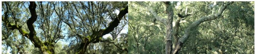
These montados are quite diverse in species, tree cover and structure, as it can be observed
below, in Figure 1. One of the main characteristics of these traditional, multi-functional
and bio-cultural landscapes is the persistence of the native vegetation scattered through-
out the landscape, which gives rise to a heterogeneous mosaic, resulting not only from
several agricultural uses, but also from a diverse tree, shrub and herbaceous cover, thus
conferring diversity of composition and structure to the landscape. This complex for-
mation produced one of the most aesthetically pleasing and biologically rich landscapes
in Europe [10] (p. 100) and have high scientific and touristic interest.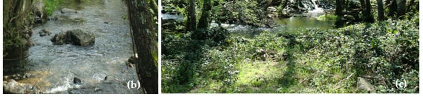
Land 2021, 10, 307                                                                                                               3 of 17

        Figure 1. Study area and types of montados in Alentejo Central (author of photos (a) and (b) and map (c): T. Batista).

                                      Since 1999, the fundamental trees of montados (Quercus rotundifolia and Quercus su-
                                 ber) have been under legal protection (Decree-Law 140/99, dated 24 April—Annex B-1,
                                 republished by Decree-Law 49/2005, of 24 February; Directive 92/43 / EEC, 21 May—An-
                                 nex I Habitat 6310; Decree-Law 169/2001 of 25 May, with amendments; Decree-Law
                                 155/04, of 30 June) and can be considered cultural heritage of high bio-cultural value. Cork
                                 and holm trees are along with olive trees the oldest trees in the Iberian Peninsula. Its wood
                                 is very strong and resistant and for this it was part of the raw material used to build the
                                 Portuguese marine fleet during the Discoveries.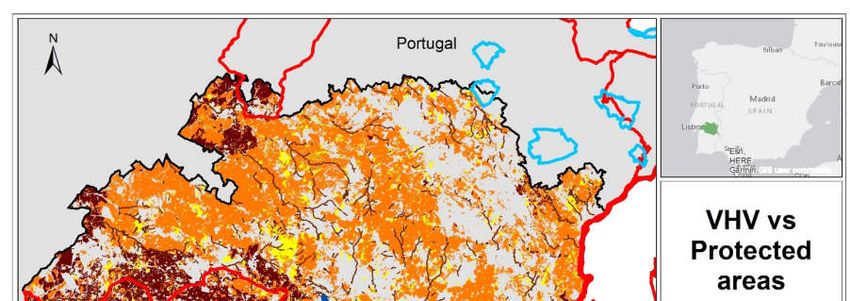
Land 2021, 10, 307                                                                                                        4 of 17

                                 1.2. Heritage Landscapes and Vegetation Heritage Value (VHV)
                                       Several types of values can be attributed to cultural landscapes, depending on the
                                 scientific approach of the experts or the modes of assigning stakeholders groups. Since
                                 heritage value is one of these types, the most valuable cultural landscapes can be desig-
                                 nated as a heritage landscape. In other terms, the heritage landscape must then be consid-
                                 ered as a cultural landscape of high patrimonial value [11]. As mentioned, vegetation
                                 should be regarded as an important factor, which conditions the value of landscape her-
                                 itage and should be evaluated not only per se, but also as a habitat for many wild animal
                                 species. The heritage value of vegetation must, thus, be considered as a key factor in se-
                                 lecting the most interesting areas for the conservation of nature and vegetation in partic-
                                 ular.

                                 2. Materials and Methods
                                       The model used for the estimation of the heritage value of the vegetation is based on
                                 the following criteria: evaluation of the horizontal and vertical structure of the vegetation
                                 patches and their importance as habitat, tree cover density, rare species richness, phyto-
                                 coenosis maturity, importance as ecological corridor, historical record, scientific, educa-
                                 tional and recreational potential.
                                       These criteria were applied to the best-preserved vegetation patches, such as cork
                                 oak and holm oak montados, forests and woods, shrubs, meadows and marshes, vegeta-
                                 tion corridors (river corridors mainly) including protected habitats and species with a con-
                                 servation status. Agricultural and pastoral intensive areas were excluded from this anal-
                                 ysis. The structure and composition of the vegetation were analyzed through the Corine
                                 Land Cover Map at the 1:10,000 scale elaborated by CIMAC – Intermunicipal Community
                                 of Alentejo Central, in 2008 [12]. This cartography is quite rich in information. It applies
                                 the Corine Land Cover Legend developed to the 1:10,000 scale (CLC5), with a 5 digits
                                 legend and 295 land use/land cover classes [13]. It also integrates field information such as
                                 the type of undercover vegetation and the percentage of tree canopy cover (50%). It has a minimal cartographic unit of 0.5 hectares, and it was validated for
                                 land use and rare species through field surveys. An example of the CLC5 legend is pre-
                                 sented bellow on Table 1.

             Table 1. Extract from the legend Corine Land Cover level 5 (CLC5), details and number of patches analyzed.

                                                                                                                  Number of
                                                                          Tree Density Details in Under-
         Code_CLC5                        Description                                                            Patches Ana-
                                                                               (%)     cover Vegetation
                                                                                                                     lyzed
            3.1.1.1.2               Holm oak woods                                                                     75
            3.1.1.2.9           Holm oak and Eucalyptus                                                                18
           3.1.1.2.10     Holm oak and other broad-leaved trees                                                        7
            2.4.1.3.2           Annual crops + Holm oak                                                               2251
            2.4.1.3.1           Annual crops + Cork Oak                                                               775
           3.1.1.2.22           Eucalyptus and Holm oak                                                                26
           3.1.1.2.21           Eucalyptus and Cork oak                       (50)          Cistus spp.             1774
            2.4.4.1.2        Holm oak montado with pasture                                    Olive trees             6550
            2.4.4.3.1    Cork oak montado with permanent crops                                                        342
            2.4.4.2.1      Cork oak montado with annual crops                                                         484
            2.4.4.4.1        Cork oak montado with shrubs                                     Cistus spp.             942
            2.4.4.1.1        Cork oak montado with pasture                                                            2957
            2.4.4.2.3       Mixed montado with annual crops                                                           169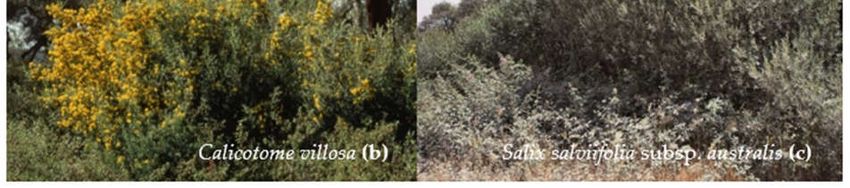
Land 2021, 10, 307                                                                                                     5 of 17

            2.4.4.4.3       Mixed montado with shrubs                                   Cistus spp.             637
            2.4.4.1.3       Mixed montado with pasture                                                         2173
           3.1.1.2.27   Holm oak and other broad-leaved trees                                                    1
           3.1.1.2.26   Cork oak and other broad-leaved trees                                                    1
            3.1.3.1.8         Resinous and Holm oak                                                             144
            3.1.3.1.7          Resinous and Cork oak                                                            919
            3.1.1.1.1              Cork oak wood                                                                629
            3.1.1.2.1        Holm oak + Cork oak wood                                                            15
            3.1.1.2.4         Cork oak and Eucalyptus                                                            37
            3.1.1.2.5   Cork oak and other broad-leaved trees                                                    8
                                                                                           Total               22745

                                  Three or two evaluation classes were considered, depending on the nature of each
                             criterion [14]. Using a general scale of values (convenience scale), a numerical value was
                             assigned to each class, allowing the linear combination of the weighted criteria and the
                             estimation of Vegetation Heritage Value (VHV) as following [11],
                                                                          n
                                                                VHV = Σ ai . Xi
                                                                        i =1
                            (n—number of indicators; ai—weighting coefficient; Xi—value assigned to indicator i).
                                  For the selection of the weighting coefficients a relatively precise strategy was ap-
                             plied according to [14] and [15]. The definition of each criterion, as well as the correspond-
                             ing weighting coefficient and number of evaluation classes are presented in the 2.3 section.
                             Finally, the VHV was converted into a 0–100 scale. This methodology was applied to the
                             Corine Land Cover Map of Alentejo Central region, at 1:10,000 scale, in a vectorial format,
                             with a total of 22,745 analyzed patches. All the map algebra was undertaken with ArcMap
                             GIS.

                             2.1. Origin and Development of the Methodology
                                   The first known occurrence in which a heritage value was quantified through a
                             weighted linear combination of estimated values of descriptors took place in the course of
                             the Environmental Impact Assessment (EIA) of the Alqueva Dam Project, carried out be-
                             tween 1984 and 1987 [16]. This methodology was then applied not only to archaeological
                             heritage [17] but also to vegetation heritage [18]. In this EIA, the vegetation, besides having
                             been valued from the patrimonial point of view, was also analyzed in terms of functional
                             value (as habitat of animal communities) and economic value [16].
                                   Given the need to improve the method, with the introduction of new criteria, new
                             studies were carried out within the framework of the activities of the University of Évora
                             [19,20]. These studies, especially those related to the built heritage, were based on works
                             by well-established authors, such as [21] (see particularly pp. 34–35), [22,23], and lately,
                             [24,25], among others. As regards to the natural heritage, the analysis of the evaluation
                             criteria has been supported mainly in [26–34]. It should be noted that this analysis sought
                             to avoid the introduction of criteria that could create redundancy situations, which is why,
                             for example, naturalness and wilderness were not considered. In order to evaluate the
                             cultural landscape from the heritage point of view, it was necessary to consider new eval-
                             uation criteria [11,14,35] the available bibliography being already very extensive, with a
                             special emphasis on [36–42], and [24]. With the international acceptance of the concept of
                             intangible heritage, special criteria extended to landscapes had to be introduced [43,44]
                             and there is already a wide bibliographic database availability, such as [45,46], among oth-
                             ers. Finally, as mentioned previously, in the development of this evaluation methodology,
                             a strategy for selecting the weighting coefficients was defined, an aspect that is considered
                             central to the feasibility of the method [14,15].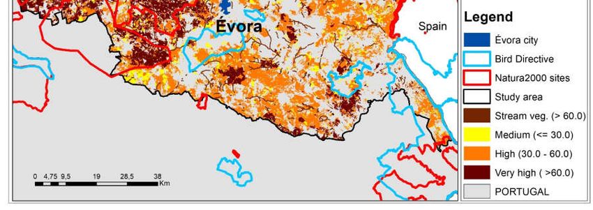
Land 2021, 10, 307                                                                                           6 of 17

                     2.2. Potential Area for Vegetation Conservation Purposes
                          As already mentioned, potential areas for vegetation conservation purposes were se-
                     lected based on the estimation of the heritage value of the vegetation. This estimation was
                     based on the use of several criteria, whose characterization is exposed as following:

                     2.2.1. Horizontal and Vertical Structure—Importance as Habitat
                          These criteria describe landscape patches through structural attributes of the ecosys-
                     tem, related to their composition (internal heterogeneity), such as the height of different
                     vegetation layers (vertical strata) and the complexity of the composition (horizontal
                     patches).
                          The vertical structure diversity is related to the vertical distribution of the plants ac-
                     cording to the three main levels: herbaceous, shrub and arboreal. It was classified accord-
                     ing to the number of dominant vertical strata such as:
                          1—Only one strata (herbaceous, shrubs, trees);
                          2—Two strata (herbaceous + shrubs; herbaceous + trees);
                          3—Three strata (herbaceous + shrubs + trees).
                          The horizontal structural diversity refers to the number of dominant species in each
                     vegetation patch given by the number of land cover types in a patch and it was classify
                     such as:
                          1—One dominant specie;
                          2—Two dominant species;
                          3—Domain of three or more species.
                          The tree canopy density was also considered since it is an important factor on habitat
                     quality as well as on the energy and nutrients fluxes. It influences for instant, the quality
                     of woodland species habitat [43]. Tree canopy density refers to the density of the tree cover
                     and it is classified into 3 classes according to the following tree density ranges:
                          1—less than 10%;
                          2—between 10 and 50%;
                          3—more than 50%;
                          All these habitat characteristics are considered as habitat indicators, being important
                     factors in the assessing of the potential of the area for conservation purposes.

                     2.2.2. Vegetation Rarity
                          According to [30], rarity is mostly a consequence of a confinement of species or com-
                     munities to specific niches, or an adaptation to particular environmental conditions. It is
                     therefore a natural characteristic of specific communities and their site conditions.
                          In the central region of Alentejo (southern Portugal) there are several Natura 2000
                     habitats, such as the montados (habitat 6310). In these ecosystems, one can find flora be-
                     longing to the Natura 2000 Annexes, such as Narcisus bulbucodium, Narcisus fernandesii,
                     Ruscus aculeatus and Halimium verticillatum. In addition, as a result of continuous anthro-
                     pogenic activity in this territory, different perennial grasses dominated by Poa bulbosa
                     (habitat 6220 *) can be found in abundance. Dense pre-forested coverings (habitat 5330)
                     are also important, including some restricted distribution subtypes, belonging to the
                     thorny bushes of Calicotome villosa. In spite of the rare presence of climax forests, some
                     cork oak (9330) and holm oak (9340) forests are present, and Ruscus aculeatus invariably
                     appears under-cover [47,48]. Along the streams, three types of tree galleries are present,
                     mainly consisting of: ash trees (91B0), alders (91E0) and willows (92A0), including some
                     rare species such as Salix salviifolia subsp. australis.
                          In this study, the species rarity richness refers to the number of rare species with
                     conservation status.
                          The areas where these rare species can be found are of great importance not only to
                     the existing species conservation but also to maintain the flow of genes among them [30].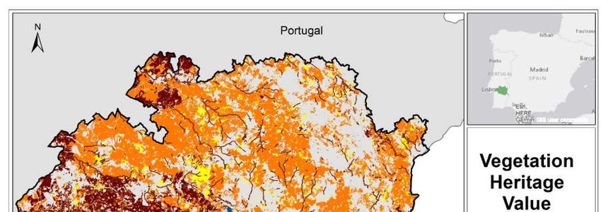
Land 2021, 10, 307                                                                                           7 of 17

                     The protection of rare species and communities may act as an ‘umbrella’ for the biodiver-
                     sity preservation in general.

                     2.2.3. Phytocoenosis Maturity
                          According to Merriam-Webster Unabridged Dictionary, phytocoenosis can be de-
                     fined as the whole body of plants occupying a particular habitat. Phytocoenosis maturity
                     degree is related with the distance of an ecosystem in its current form, to its assumed
                     natural state in the total absence of human activity over time [30].
                          Our estimation of phytocoenosis maturity was based on the seral stage of the vege-
                     tation, which is related to the concept of succession, as defined by Eugene Odum. In his
                     "maturity concept" this author postulated a general "strategy of ecosystem development",
                     which is a well ordered process of community development resulting from changes in the
                     physical environment caused by the ecosystem itself [49].
                          According to Frederick R. Gehlbach [50], “heritage value is a potentially important
                     feature of natural areas, because it can be represented by climax communities (pre-settle-
                     ment landscapes), the most stable nature provides”. There is a close relationship between
                     its heritage value criterion for evaluation of natural areas [50] (p. 84) and phytocoenotic
                     maturity. This author estimates heritage value considering two classes: Late seral stage,
                     and climax condition.
                          In this study, considering phytocoenosis maturity as the position of vegetation for-
                     mation in the phytocoenotic series, three valuation classes were assumed, according to the
                     distance to climax [51],
                          1—young,
                          2—medium and
                          3—mature

                     2.2.4. Vegetation Corridors
                           Ecological corridors are considered to be one of the most relevant characteristics of
                     the landscape due to their important role in the connection between vegetation patches,
                     reducing fragmentation and isolation, and favoring water, energy and material flows.
                     Corridors are defined by Forman and Godron [52] as narrow strips of land which differ
                     from the matrix on either side.
                           Hoechstetter [53] argues that corridors can be considered as a special type of spot: a
                     ‘longish’ patch, which is separately considered because of its important functional role in
                     landscapes. Corridors can also be defined according to their functional character - as nar-
                     row strips of habitat surrounded by habitat of other types [54].
                           Corridors are especially characterized by their connectivity over large distances and
                     by environmental gradients between adjacent areas [52]. Corridors can be classified as:
                     linear corridors (such as roads, hedges, property boundaries, drainage ditches and irriga-
                     tion canals); strip corridors and river corridors (bordering waterways) [52].
                           Particularly important are vegetation corridors associated with habitats and connec-
                     tivity. The most important corridors are the riparian ones, the hedges along walls and
                     fences, and the road corridors. Such corridors may consist of trees, shrubs and herbaceous
                     formations with varied compositions. In Mediterranean conditions riparian corridors are
                     composed mainly of willow trees (Salix atrocinerea, Salix neotricha and Salix salvifolia subsp.
                     australis), ash trees (Fraxinus angustifolia), alders (Alnus glutinosa), poplars (Populus nigra
                     and Populus alba) and elm trees (Ulmus minor).
                           The effectiveness of ecological networks is greatly conditioned by vegetation corri-
                     dors. An ecological network is defined by Bennett and Wit [55], as ‘a coherent system of
                     natural and/or semi-natural landscape elements that is configured and managed with the
                     objective of maintaining or restoring ecological functions as a means to conserve biodi-
                     versity while also providing appropriate opportunities for the sustainable use of natural
                     resources [56] (p. 8).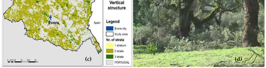
Land 2021, 10, 307                                                                                              8 of 17

                          In this study, the importance of the ecological corridor criterion concerns the exist-
                     ence of flow corridors and their complexity and functional connectivity. In this study they
                     were classified as following:
                          0—no corridor present;
                          1—existing corridor.

                     2.2.5. Historical Record
                           The historical record refers to the existence or not of historical research data. Using
                     historic and recent vegetation records it is possible to study the vegetation change at sev-
                     eral scales (local, regional or supra-regional) [31]. Vegetation, in terms of composition and
                     structure, is closely related to past land use. Most of the present woods and montados
                     occupy areas previously used by agriculture and pasturing, reflecting the potential vege-
                     tation and the processes of natural and human disturbance [57]. A long recorded history
                     enhances educational and scientific values, and could also contribute to more effective
                     management techniques [58].
                           Although this criterion has often been used since at least the 1980s [59], it is of relative
                     interest as it does not correspond to an inherent feature of the site and it is difficult to be
                     quantifiable. For these reasons it should be treated as an ancillary criterion [60] (p. 237). In
                     this study, the vegetation formations were classified as following:
                           0—low record;
                           1—high record.

                     2.2.6. Scientific and Educational Potential
                           This criterion mainly focuses on species and plant communities confined to specific
                     niches, or adapted to specific environmental conditions, but also on those located in areas
                     with a long history of land use that have often conditioned soil properties and diversity
                     [30]. As the old forests are of great importance for the conservation of biodiversity, small
                     fragments of such existing forests may constitute reservoirs for the propagation of relict
                     species in younger formations [30].
                           Without questioning the importance of this criterion, its practical application be-
                     comes complex as it depends not only on the intrinsic interest of the vegetation, but also
                     on the geographical location of the site, particularly with regard to ease of access and dis-
                     tance from the university or from the research center. For such reasons, it should be used
                     as an ancillary criterion [60]. In this study, the vegetation formations were classified as
                     follows:
                           0—low potential;
                           1—high potential;

                     2.2.7. Recreation potential.
                           This criterion concerns the attractiveness of vegetation formations for recreational
                     activities, such as hiking, nature photography and others. Vegetation plays an important
                     role in the composition of rural landscape that can be evaluated for their bucolic and aes-
                     thetic aspects, with no acknowledgment of the role of farming. This is the expectation
                     shared by foreign visitors staying generally for relatively short periods, who walk or go
                     on bicycle or horse tours in this landscape. They can catch an impression based on the
                     aesthetical and environmental quality of the landscape and appreciate natural and cul-
                     tural heritage.
                           Since vegetation structure largely determines the aesthetic and environmental qual-
                     ity of the landscape, it plays a major role as a source of artistic inspiration and human
                     well-being. On the other hand, the cultural heritage present in cork and holm oak mon-
                     tados does not only cover the tangible elements but also the intangible ones. Many mon-
                     tado intangible heritage values have a great potential for rural tourism development, like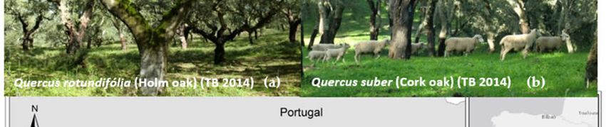
Land 2021, 10, 307                                                                                                    9 of 17

                          craftworks, gastronomy, local traditional and popular knowledge, legends and beliefs
                          [44].
                               The installation of walking paths through montado landscapes will favor users' con-
                          tacts with the multifunctional characteristics and activities of these agro-silvo-pastoral
                          systems and, in particular, their natural and cultural heritage values [61,62]. Given the rel-
                          ative subjectivity that involves this criterion, it should be treated secondarily. In this
                          study, the vegetation formations were classified as following:
                               0—low potential;
                               1—high potential.

                          2.3. Integrated Analysis and GIS
                               The selected criteria were applied to the land use patches of the Corine Land Cover
                          Map, at level 5 and 1:10,000 scale. The use of GIS to analyze all the valued criteria, permit-
                          ted the calculation of the VHV for more than 22,000 land cover patches. The criteria are
                          briefly presented, as well as the scale of valorization used on the Table 2.

                          Table 2. Vegetation Heritage Value (VHV): Criteria, weighting coefficients and evaluation classes.

                                                                                              Weighting Co- Number of
                             Criterion                         Description
                                                                                                efficient    Classes
                                               Horizontal Structure (1, 2 and 3 or more
                                                                                                     4              3
                                                        species in consociation)
                        Vegetation Structure
                                               Vertical structure (1, 2 or 3 vertical stra-
                                                                                                     4              3
                                               tus - herbaceous, scrubs or tree stratus)
                                                Refers to tree cover density (50%).
                                                Number of rare species with conserva-
                       Species rarity richness                                                       4              3
                                                               tion status
                                               Position of the formation in the vegeta-
                      Phytocoenosis maturity                                                         3              3
                                               tion series: young, medium and mature
                     Importance as ecological Connectivity and other ecological func-
                                                                                                     4              2
                              corridors                           tions
                          Historical record       Existence of historical research data              1              2
                                                  Concerns the vegetation formations
                        Scientific and educa-
                                                 with high interest to future research               3              2
                           tional potential
                                                       and educational activities
                                                Concerns the attractiveness of vegeta-
                        Recreation potential                                                         1              2
                                                tion formations to recreation activities

                          3. Results and Discussion
                               In regard to each of the criteria valued in the methodology it was considered in the
                          case of the horizontal and vertical structure, presented in the Figure 2, that the most pre-
                          served vegetation patches are composed of the three strata (herbaceous, shrubs and trees),
                          indicating generally their presence in the least human disturbance. This is quite important
                          in fauna species that use these types of vegetation patches as habitat for food, shelter and
                          reproduction functions.
                               The horizontal structure is connected with the number of dominant tree species. In
                          the study areas there are two dominant Quercus species: The olm oak (Quercus rotundifolia)
                          and the cork oak (Quercus suber). These are trees with hundred years old or more, pro-
                          tected by the Portuguese law, most of them relict from the previous Mediterranean forest,
                          integrating nowadays the montado landscape.
                               The greater is the tree density, the greater the importance for conservation, as this
                          density allows for the development of core species. Less tree density creates the porosity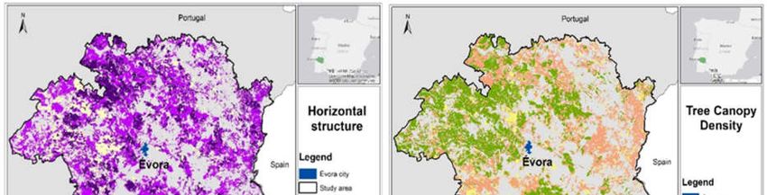
Land 2021, 10, 307                                                                                                       10 of 17

                                effect in the landscape, which promotes the exchange of energy and materials, resulting
                                in the decrease in core species. In the Figure 2, we can see the location of the more and less
                                dense vegetation patches.

      Figure 2. Horizontal and vertical vegetation structure; Tree cover/canopy density (author of maps (a), (b) and (c) and
      photo (d): T. Batista).

                                     In addition to the structural criteria previously mentioned, the existence of rare spe-
                                cies was also considered. In the study area, these rare species are connected with the mon-
                                tado and pastural habitats.
                                     The rare species or species with preservation status, that occur in the study area in-
                                cluding Quercus suber and Quercus rotundifolia, are: Salix salviifolia subsp. australis , Thymus
                                capitellatus, Thymus villosus, Narcisus bulbocodium, Malcolmia lacera, Ruscus aculeatus, Eu-
                                phorbia transtagana Boiss, Narcisus fernandesii, Armeria pinifolia, Festuca duriotagana and Hy-
                                acinthoides vicentina spp transtagana In the map bellow (Figure 3), we can identify the num-
                                ber of rare species per UTM grid (1 km × 1 km) [63].
Land 2021, 10, 307 11 of 17
Figure 3. Rare vegetation species in the study area (Natura 2000 Annexes) (authors of the map (a): T. Batista, P. Mendes
and C. P. Gomes) (author of the photos (b) and (c): J.M. de Mascarenhas).
The phytocoenosis maturity criterion allows us to perceive the state of proximity to
the climax situation wich is relevant in terms of conservation management. In the study
area it was considered that the vegetation is mainly in two phytocenotic stages: low (the
case of montados with crops) and medium (montados with high shrubs).
The vegetation corridors are also important landscape features, not only as habitat,
but also due to the barrier effect and the fact that they favour the connectivity of fauna
species. In this analysis, we mapped the most structured and lush vegetation river corri-
dors, composed of arboreal and shruby vegetation (Figure 4).Land 2021, 10, 307 12 of 17
Figure 4. Vegetation stream corridors in the study area (author of the map (a) and photos (b) and (c): T. Batista).
Non-intrinsic vegetation criteria were also applied, such as historical record, scien-
tific and educational potential, interest and recreational potential interest, although these
criteria has been assumed with lower weighting coefficients. The entire study area was
considered to have high scientific and educational potential, high recreational interest, as
well has a high historical record. As these criteria are often difficult to measure, a subjec-
tive appreciation was made based on the experience of one of the authors that is an expert
in the vegetation of the region. Also, the authors considered that this was the necessary
detail for this methodological essay approach.Land 2021, 10, 307 13 of 17
The overall results obtained with the application of this method allowed the identifi-
cation of the most important areas of vegetation heritage. From the 7500 km2 analyzed,
52% are natural and semi-natural areas, and of these, 18.8% have very high VHV; 70.7%
high VHV, and only 10.5% have medium VHV (Figure 5).
(b)
Figure 5. VHV map of the study area (author: T. Batista).
It is important to note that in the current protected areas (Natura 2000 sites of Mon-
furado, Cabrela and Cabeção) (Figure 6), the most significant part of very high VHV is
enclosed; however the application of the method also revealed the existence, outside of
these protected areas, of many important sites with very high and high vegetation herit-
age value.
We can also observe in the Figure 6 that the areas of special protection for birds (ZPE
– Bird Directive), are actually linked to agricultural areas. These results are quite relevant,
since they permitted the identification of the fundamental sites for the vegetation preser-
vation. They show the strength of the methodology and the potential of its application in
other areas.
These sites should deserve special attention by nature conservation authorities, in-
cluding the regional and local ones, as well as by land managers and experts.Land 2021, 10, 307 14 of 17
Figure 6. Interception of VHV map with the Protected Areas (Nature 2000 sites and Bird Directive sites) (author: T. Batista).
4. Conclusions
Although environmental values have been studied for a few decades, with many
published works [29] , the approach to vegetation in terms of heritage, particularly in an
integrated framework, did not deserve due attention from the planning experts. By way
of example, the Natural Heritage Vegetation Database for West Virginia (USA) was only
made public in last decade [64]. Except for the administrative mechanisms, leading to the
protection of certain plant assemblies or elements, such as historic gardens, monumental
trees and rare species and formations [26], there are few methods developed for the herit-
age valuation of vegetation, from a practical perspective useful to conservation and land
planning.
The presented essay shows that the method is very understandable and easy to ap-
ply, even in large areas (this case-study concerns a 7500 km2 area), and can be replicated
in different regions and continents. This methodology allowed to identify potential areas
for conservation purposes in the Alentejo Central region and it was observed that these
areas correspond in several places with the current Natura 2000 sites. However, we are
aware that its application implies a deep knowledge of the territory’s vegetation and the
existence of adequate cartography.
The method can still be improved, in particular, by introducing new evaluation cri-
teria or new methods for selecting weighting coefficients. Other criteria of biological na-
ture, but others in the fields of the human sciences (such as anthropology and other intan-
gible heritage domains) may be considered in the assessment of vegetation heritage value.
Author Contributions: Conceptualization, T.B., J.M.d.M., P.M. and C.P.-G.; methodology, T.B.,
J.M.d.M., P.M. and C.P.-G.; software, “Not applicable”; validation, T.B., J.M.d.M., P.M. and C.P.-G.;
formal analysis, T.B., J.M.d.M., P.M. and C.P.-G.; investigation, T.B., J.M.d.M., P.M. and C.P.-G.;
resources, “Not applicable”; data curation, “Not applicable”; writing—original draft preparation,Land 2021, 10, 307 15 of 17
T.B., J.M.d.M., P.M. and C.P.-G.; writing—review and editing, T.B., J.M.d.M., P.M. and C.P.-G.; vis-
ualization, “Not applicable”; supervision, T.B., J.M.d.M., P.M. and C.P.-G.; project administration,
“Not applicable”; funding acquisition, T.B., J.M.d.M. and C.P.-G. All authors have read and agreed
to the published version of the manuscript. Opinions and considerations are the sole responsibility
of the authors who issues them.
Funding: This work is funded by National Funds through FCT - FOUNDATION FOR SCIENCE
AND TECHNOLOGY (Portugal) under the Projects UIDB/05183/2020 (MED) and UIDB/00057/2020
(CIDEHUS) and co-financed by the ERDF—EUROPEAN REGIONAL DEVELOPMENT FUND
through the INTERREG V-A España-Portugal Program (POCTEP) 2014-2020, under the project
0753_CILIFO_5_E: Centro Ibérico para la Investigación y Lucha contra Incendios Forestales.
Institutional Review Board Statement: Not applicable.
Informed Consent Statement: Not applicable.
Data Availability Statement: MDPI Research Data Policies.
Acknowledgments: To MED, CIDEHUS and ICT Research Centres of the University of Évora, for
institutional and administrative support, and to CIMAC—Intermunicipal Community of Alentejo
Central for technical support.
Conflicts of Interest: The authors declare no conflicts of interest.
References
1. Choay, F. L'Allégorie du Patrimoine; SEUIL: Paris, France, 1996.
2. UNESCO. World Heritage Centre’s Natural Heritage Strategy; The UNESCO World Heritage Centre: Paris, France, 2006. Available
online: https://whc.unesco.org/en/naturalheritagestrategy/ (accessed on 25 February 2021).
3. UNESCO. Convention Concerning the Protection of the World Cultural and Natural Heritage; UNESCO: Paris, France, 1972. Available
online: https://whc.unesco.org/archive/convention-en.pdf (accessed on 25 February 2021).
4. Harrison, R. Beyond “Natural” and “Cultural” Heritage: Toward an Ontological Politics of Heritage in the Age of Anthropo-
cene. Herit. Soc. 2015, 8, 24–42. Available online: https://www.tandfonline.com/doi/full/10.1179/2159032X15Z.00000000036 (ac-
cessed on 25 February 2021).
5. Audrerie, D. La Notion Et la Protection du Patrimoine; Presses Universitaires de France: Paris, France, 1997.
6. Leitão, L. Bridging the Divide between Nature and Culture in the World Heritage Convention: An Idea Long Overdue? Georg.
Wright Forum 2017, 34, 195–210.
7. Mallarach, J.-M.; Verschuuren, B. Changing Concepts and Values in Natural Heritage Conservation: A View through IUCN
and UNESCO Policies. In Values in Heritage Management: Emerging Approaches and Research Directions; Avrami, E., Macdonald,
S., Mason, R., Myers, D., Eds.; The Getty Conservation Institute: Los Angeles, CA, USA, 2019. Available online:
http://www.getty.edu/publications/occasional-papers-3/part-two/10/ (accessed on 14 January 2021).
8. Batista, T.; de Mascarenhas, J.M.; Mendes, P.; Pinto-Gomes, C. Vegetation heritage value in Central Alentejo (Portugal) land-
scape: A GIS approach. In Proceedings of the Poster Presented at the IALE 2013 Congress, Manchester, UK, 9–12 September
2013.
9. Pinto-Correia, T.; Ribeiro, N.; Sa-Sousa, P. Introducing the montado, the cork and holm oak agroforestry system of Southern
Portugal. Agrofor. Syst. 2011, 82, 99–104.
10. Pinto-Correia, T.; Mascarenhas, J.M. Montado (Dehesa) of Portugal and Spain. In Threatened Landscapes Conserving Cultural En-
vironments; Green, B., Vos, W., Eds.; Spon Press: London, UK; New York, NY, USA, 2001; pp. 100–101.
11. Capelo, S.; Barata, F.T.; de Mascarenhas, J.M. Why are cultural landscapes of various values? Thinking about heritage landscape
evaluation and monitoring tools. J. Landsc. Ecol. 2011, 4, 5–17.
12. Batista, T. Carta de ocupação e uso do solo do Distrito de Évora e Município de Sousel. In Map of Land Occupation and Use of the
District of Évora and Municipality of Sousel; CIMAC: Évora, Portugal, 2011.
13. Guiomar, N.; Batista, T.; Fernandes, J.P.; Souto Cruz, C. Corine Land Cover Nível 5. Contribuição Para a Carta de Uso do Solo em
Portugal Continental; AMDE (CIMAC): Évora, Portugal, 2009.
14. Capelo, S.; Barata, F.T.; de Mascarenhas, J.M. Caring about cultural landscapes: Looking for heritage evaluation and monitoring
tools. In Proceedings of the International Conference ‘Landscapes of everyday life’, Séssion Plénière 3-Atelier C, Perpignan, France and
Girona, Spain, 2011; Ministère de l’Ecologie, de l’Energie, du Développement Durable, et de l’Aménagement du Territoire: Paris,
France, 2011; pp. 1–19.
15. Capelo, S.; de Mascarenhas, J.M.; Barata, F.T. Monitoring indicators as an important tool to assess the quality of heritage land-
scape along the time. Probl. Landsc. Ecol. 2011, 30, 241–248.
16. Pessoa, A.; Bettencourt, A.; Mascarenhas, J.M.; Matos, M.A. D.I.A. ALQUEVA–Declaração de Impacto Ambiental. Estudos de
Impacto Ambiental do Empreendimento de Alqueva. In D.I.A. ALQUEVA–Environmental Impact Statement. Environmental Impact
Studies of Alqueva Dam; DRENA-Empresa Geral de Fomento: Lisboa, Portugal, 1987.Land 2021, 10, 307 16 of 17
17. Mascarenhas, J.M.; Soares, J.; Tavares da Silva, C. Proposta de Metodologia para Avaliação do Impacto de Barragens no Domí-
nio Histórico–Arqueológico [Proposal of Methodology for Dams Impact Assessment in the Historical–Archaeological Domain].
Trab. Arqueol. Sul. 1986, 1, 7–16.
18. Malato-Beliz, J.V.; Mascarenhas, J.M.; Bettencourt, A.; Teles Grilo, J. Estudo de Impacte Ambiental na Vegetação Natural da
Barragem de Alqueva. In Proceedings of the 1st International Symposium of Landscape Ecology, Évora, Portugal, 1996; Pinto-Gomes,
C. J., Ed.; Universidade de Évora: Évora, Portugal, 1996; pp. 31–69.
19. Mascarenhas, J.M. Évora: Archeology and Conservation of the surrounding landscape. In Cité et Térritoire; Clavel-Lévêque, M.,
Plana-Mallart, R., Eds.; Annales Littéraires de l’Université de Besançon: Besançon, France, 1995; Volume 565, pp. 227–230.
20. Barata, F.T.; de Mascarenhas, J.M. Preservando a Memória do Território/Preserving the Land’s Memories. O Parque Cultural de
Tourega–Valverde/The Tourega-Valverde Cultural Park; Centro de Estudos de Ecossistemas Mediterrânicos–Universidade de
Évora: Évora, Portugal, 2002.
21. Darvill,T.C. Ancient Monuments in the Countryside: An Archaeological Management Review; English Heritage: Swindon, UK, 1987.
22. Carver, M. On Archaeological Value. Antiquity 1996, 70, 45–56.
23. Mason, R. Assessing Values in Conservation Planning: Methodological Issues and Choices. In Assessing the Values of Cultural
Heritag; De La Torre, M., Ed.; The Getty Conservation Institute: Los Angeles, CA, USA, 2002; pp. 5–30.
24. Tengberg, A.; Fredholm, S.; Eliassona, I.; Knez, I.; Saltzman, K.; Wetterberg, O. Cultural ecosystem services provided by land-
scapes: Assessment of heritage values and identity. Ecosyst. Serv. 2012, 2, 14–26.
25. Fredheim, L.H.; Khalaf, M. The significance of values: Heritage value typologies re-examined. Int. J. Herit. Stud. 2016, 22, 466–
481.
26. Dubost, F. Vert Patrimoine, La Constitution d’un Nouveau Domaine Patrimonial; La Maison des Sciences de l’Homme: Paris, France,
1994.
27. Balmer, J.; Whinam, J.; Kelman, J.; Kirkpatrick, J.B.; Lazarus, E. A Review of the Floristic Values of the Tasmanian Wilderness World
Heritage Area; Nature Conservation Report No. 2004/3; Department of Primary Industries Water and Environment: Hobart,
Australia, 2004.
28. Ejrnæs, R. Valuation of Habitats for Conservation: Concepts, Methods and Applications; Nordic Council of Ministers: Copenhagen,
Denmark, 2005.
29. O’Neill, J.; Holland, A.; Light, A. Environmental Values; Routledge: Abingdon, UK; New York, NY, USA, 2008.
30. Schultze, J.; Gärtner, S.; Bauhus, J.; Meyer, P.; Reif, A. Criteria to evaluate the conservation value of strictly protected forest
reserves in Central Europe. Biodivers. Conserv. 2014, 23, 3519–3542.
31. Kosanic, A.; Anderson, K.; Frère, C.H.; Harrison, S. Regional vegetation change and implications for local conservation: An
example from West Cornwall (United Kingdom). Glob. Ecol. Conserv. 2015, 4, 405–413.
32. Davis, M.; Head, N.J.; Myers, S.C.; Moore, S.H. Department of Conservation Guidelines for Assessing Significant Ecological Values;
New Zealand Department of Conservation: Wellington, New Zealand, 2016.
33. Capmourteres, V.; Anand, M. Conservation value: A review of the concept and its quantification. Ecosphere 2016, 7, e01476.
Available online: https://esajournals.onlinelibrary.wiley.com/doi/epdf/10.1002/ecs2.1476 (accessed on 6 January 2021).
34. Gastón, A.; Blázquez-Cabrera, S.; Ciudad, C.; Mateo-Sánchez, M.C.; Simón, M.A.; Saura, S. The role of forest canopy cover in
habitat selection: Insights from the Iberian lynx. Eur. J. Wildl. Res. 2019, 65, doi:10.1007/s10344-019-1266-6.
35. Batista, T.; de Mascarenhas, J.M.; Mendes, P.; Mantas, V. Heritage Landscapes in Évora surroundings: A GIS approach. In Pro-
ceedings of the 27th ECLAS Conference ‘Cultural Landscape’, Istambul, Turkey, 2010; Yildizci, A.C., Ed.; ECLAS and ITU: Istambul,
Turkey, 2010; pp. 791–802.
36. Schapper, J.A. Criteria for the Evaluation of Landscape as Heritage. Ph.D. Thesis, School of Environmental Planning, Faculty of
Architecture and Planning, The University of Melbourne, Melbourne, Australia, 1994.
37. Bruns, D.; Green, B.H. Identifying threatened, valued landscapes. In Threatened Landscapes, Conserving Cultural Environments;
Green, B., Vos, W., Eds.; Spon Press: London, UK, 2001; pp. 119–127.
38. Lowenthal, D. Natural and cultural heritage. Int. J. Herit. Stud. 2005, 11, 81–92.
39. Luginbühl, Y. Paysage et identification, qualification et objectifs de qualité. In Paysage et Développement Durable: Les Enjeux de la
Convention Européenne du Paysage; Dejeant-Pons, M., Buergi, E., Eds.; Conseil de l’Europe: Strasbourg, France, 2006; pp. 107–125.
40. Stephenson, J. The Cultural Values Model: An integrated approach to values in landscapes. Landsc. Urban Plan. 2008, 84, 127–
139.
41. Butler, A. Dynamics of integrating landscape values in landscape character assessment: The hidden dominance of the objective
outsider. Landsc. Res. 2016, 41, 239–252.
42. Taylor, K. Cultural landscape meanings and values. In Research in Landscape Architecture: Methods and Methodology; Van Den
Brink, D., Bruns, A., Tobi, H., Bell, S., Eds.; Routledge: New York, NY, USA, 2017; pp. 211–234.
43. de Mascarenhas, J.M.; Barata, F.T.; Capelo, S. Intangible heritage and cultural landscapes: Improving an evaluation system. In
Sharing Cultures 2017, Proceedings of the 5th International Conference on Intangible Heritage, Barcelos, Portugal, 2017; Lira, S.,
Amoêda, R., Pinheiro, C., Eds.; Green lines institute for sustainable development: Barcelos, Portugal, 2017; pp. 265–273.
44. Batista, T.; de Mascarenhas, J.M.; Mendes, P.; Carriço, C. Montado intangible heritage in Southern Portugal. In Sharing Cultures
2017, Proceedings of the 5th International Conference on Intangible Heritage, Barcelos, Portugal, 2017; Lira, S., Amoêda, R., Pinheiro,
C., Eds.; Green Lines Institute for Sustainable Development: Barcelos, Portugal, 2017; pp. 55–67.Land 2021, 10, 307 17 of 17
45. Harmon, D.; Putney, A. (Eds.). The Full Value of Parks: From Economics to the Intangible; Rowman & Littlefield Publishers: Lanham,
MD, USA, 2003.
46. Taylor, K. The challenges of the cultural landscape construct and associated intangible values in an Asian context. In Asian
Heritage Management: Contexts, Concerns, and Prospects; Silva, K.P., Chapagain, N.K., Eds.; Routledge: Abingdon, UK, 2013;
pp.189–211.
47. Costa, J.C.; Neto, C.; Aguiar, C.; Capelo, J.; Espirito-Santo, M.D.; Honrado, J.; Lousã, M. Vascular plant communities in Portugal
(Continental, the Azores and Madeira). Glob. Geobot. 2012, 2, 1–180.
48. Ramírez, B.; Fernández, L.; Cabezas, J.; Jiménez, A.; Mendes, P.; Vila-Viçosa, C.; Pinto-Gomes, C. Bioclimatologia, Biogeografia
e Vegetação Potencial na área OTALEX C. In 2013 OTALEX C: Resultados del Proyecto; Ceballos, F., Puerto, M., Batista, T., Carriço,
C., Eds.; DGTOTU–Junta de Extremadura: Mérida, Spain, 2013; pp. 73–82.
49. Odum, E.P. The strategy of ecosystem development. Science 1969, 164, 262–270.
50. Gehlbach, F.R. Investigation, Evaluation, and Priority Ranking of Natural Areas. Biol. Conserv. 1975, 8, 79–88.
51. Batista, T.; Cavaco, J.; Mendes, P.; Vila-Viçosa, C.; Penas, A.; Río, S.; Cabezas, J.; Fernández-Pozo, L.; Arancibia, N.; Pinto-Gomes,
C. Conservation status of vegetation in the north and central area of Pardiela river basin (Évora, Portugal). Acta Bot. Gall. Bot.
Lett. 2012, 159, 177–185.
52. Forman, R.; Godron, M. Landscape Ecology; John Wiley and Sons: New York, NY, USA, 1986.
53. Hoechstetter, S. Enhanced Methods for Analyzing Landscape Structure: Landscape Metrics for Characterizing Three- Dimensional Pat-
terns and Ecological Gradients; Rhombos-Verlag: Berlin, Germany, 2009.
54. Farina, A. Principles and Methods in Landscape Ecology; Springer: Dordrecht, Netherlands, 2006.
55. Bennett, G.; Wit, P. The Development and Application of Ecological Networks: A Review of Proposals, Plans and Programmes; AIDEn-
vironment: Amsterdam, Netherlands, 2001.
56. Jongman, R. Ecological networks are an issue for all of us. J. Landsc. Ecol. 2008, 1, 7–13.
57. Eberhardt, R.; Foster, D.R.; Motzkin, G.; Hall, B. Conservation of changing landscapes: Vegetation, land-use history, and fire on
Cape Cod National Seashore. Ecol. Appl. 2003, 13, 68–84.
58. Margules, C.; Usher, M.B. Criteria used in assessing wildlife conservation potential: A review. Biol. Conserv. 1981, 21, 79–109.
59. Usher, M. Wildlife Conservation Evaluation: Attributes, Criteria and Values; Chapman and Hall: London, UK, 1986.
60. Goldsmith, F.B. Evaluating Nature. In Conservation in Perspective; Warren, A., Goldsmith, F.B., Eds.; John Wiley: Chichester, UK,
1983; pp. 233–245.
61. Carriço, C.; Batista, T.; De Mascarenhas, J.M.; Mendes, P. The Montado Great Route Sustainable Tourism: Threats and oppor-
tunities. In Proceedings of HERITAGE 2018—6th International Conference on Heritage and Sustainable Development; Amoêda, R., Lira,
S., Pinheiro, C., Zaragoza, J.M.S., Serrano, J.C., Carrillo, F.G., Eds.; Green Lines Institute for Sustainable Development: Barcelos,
Portugal, 2018; Volume 2, pp. 1681–1688.
62. Surová, D.; Pinto-Correia, T. Use and assessment of the ‘new’ rural functions by land users and landowners of the Montado in
southern Portugal. Outlook Agric. 2009, 38, 189–194.
63. Sociedade Portuguesa de Botânica. Flora-On: Flora de Portugal Interactiva. 2014. Available online: https://flora-on.pt (accessed
on 15 February 2021).
64. Vanderhorst, J.; Byers, E.A.; Streets, B. Natural Heritage Vegetation Database for West Virginia. Biodivers. Ecol. 2012, 4, 440–440.You can also read