THE PORT OF OSHAWA LAND USE PLAN - April 2021
←
→
Page content transcription
If your browser does not render page correctly, please read the page content below

THE PORT OF OSHAWA LAND USE PLAN

April 2021

                               THE PORT OF OSHAWA LAND USE PLAN   1
HOPA Ports recognizes, with gratitude, our presence on the traditional territories of the
                           Haudenosaunee and Anishinaabe nations.
    We acknowledge that HOPA’s port lands are, in Hamilton and Niagara, situated on the treaty
    territory of the Mississaugas of the Credit First Nation; and in Oshawa, on the territory of the
      Mississaugas of Scugog Island First Nation, which is covered under the Williams Treaties.
    We stand with our Indigenous neighbours in celebrating and protecting the lands and waters
          of the Great Lakes, and all they provide: life, resources, transportation and trade.

2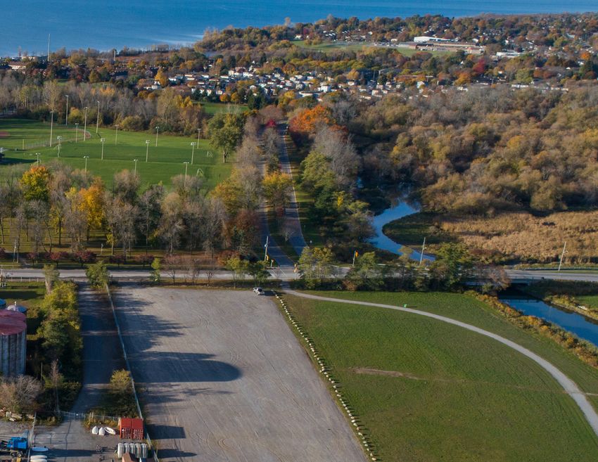
TABLE OF CONTENTS
1 INTRODUCTION                                                   1    5 MISSION & LAND USE PRINCIPLES                                                 35
  1.1 P U R P O S E O F T H E L A N D U S E P L A N              2      5.1 M I S S I O N                                                             36

  1.2 P O RT H I S TO RY                                         4      5.2 L A N D U S E P R I N C I P L E S                                         37

  1.3 P O RT L A N D H O L D I N G S                             6
                                                                      6 DEVELOPMENT CONSIDERATIONS                                                    39
  1.4 P O RT G OV E R N A N C E                                  9
                                                                        6.1 M U LT I M O DA L CO N N E CT I V I TY                                    40
  1.5 P ROV I N C I A L & M U N I C I PA L P O L I CY            10
                                                                        6.2 U R B A N D E S I G N                                                     44

2 PLAN UPDATE PROCESS                                            17     6.3 P U B L I C U S E S & P ROT E CT E D N AT U RA L S PAC E S                45

  2.1 C H A N G I N G E N V I RO N M E N T                       18     6.4 S E C U R I TY R E Q U I R E M E N T S                                    46

  2.2 CO M M U N I TY E N G AG E M E N T & CO N S U LTAT I O N   19     6.5 S U S TA I N A B I L I TY & C L I M AT E C H A N G E M I T I G AT I O N   47

                                                                        6.6 P ROJ E CT R E V I E W P RO C E S S                                       48
3 PORT CONTEXT                                                   21
  3.1 R E G I O N A L CO N T E XT                                22   7 AREA- SPECIFIC PLANS                                                          51
  3.2 S U R RO U N D I N G CO N T E XT                           24     7.1 P U R P O S E O F T H E A R E A - S P E C I F I C P L A N S               52

                                                                        7.2 L A N D U S E TY P E S                                                    54
4 THE PORT’S ROLE                                                29
                                                                        7.3 W E S T W H A R F                                                         56
  4.1 CA RG O F LOW S & S H I P P I N G                          30
                                                                        7.4 E A S T H A R B O U R                                                     62
  4.2 C U R R E N T ACT I V I TY & P O RT U S E R S              32

  4.3 F U T U R E E CO N O M I C O P P O RT U N I T I E S        33   8 MOVING FORWARD                                                                69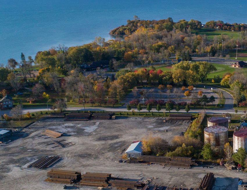
4 THE PORT OF OSHAWA LAND USE PLAN
Introduction
           THE PORT OF OSHAWA LAND USE PLAN   1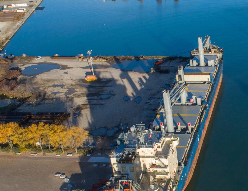
1.1 PURPOSE OF THE LAND USE PLAN

The Port of Oshawa (The Port) is one of 18 major      This Land Use Plan contains objectives and
Canadian ports deemed vital to Canada’s domestic      policies for the development of the Port of
and international trade. Originally governed by the   Oshawa over the next 10-15 years and creates a
Oshawa Harbour Commission, the management of          framework for land use planning and development
the Port transitioned to the Oshawa Port Authority    that considers:
when it was designated as a Canadian Port
Authority (CPA) under the Canada Marine Act (the      •   The current and future infrastructure needs of
Act) in 2012. In 2019, the Hamilton Port Authority        the Port;
and the Oshawa Port Authority amalgamated             •   The market demands for multimodal
to ensure the long-term sustainability of port            transportation services in the Greater Toronto
operations and to strengthen the Canadian supply          Hamilton Area (GTHA);
chain. The Hamilton-Oshawa Port Authority             •   The environmental and social aspects of
(HOPA) provides a coordinated approach to                 the Port lands and its role in the broader
port management, development, land use and                waterfront;
marketing.                                            •   Community, stakeholder and municipal
                                                          aspirations for the future of the Port and
The majority of the Port’s 63 hectares (155
                                                          surrounding areas; and,
acres) are currently occupied, and are home to
approximately 11 Port users and partners. The         •   The Port’s role as an economic driver in the
needs of the regional economy, local community            City of Oshawa and GTHA region.
and port-reliant businesses are expected to           HOPA will review the Land Use Plan every 5
grow over the coming years. It is the goal of the     years, per the requirements of the Canada Marine
updated land use plan to anticipate these needs       Act. The Land Use Plan for the Port of Oshawa is
and develop a plan for a sustainable, prosperous      distinct from municipal or other land use planning
Port of Oshawa.                                       documents. It is a framework that will guide the
                                                      Port’s evolution, and not a legislated land use
                                                      code or a detailed master plan.

2          THE PORT OF OSHAWA LAND USE PLAN
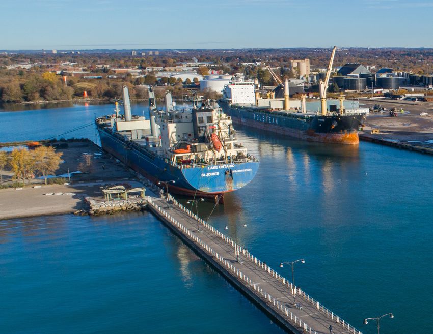
View looking southeast towards ships docked on the West and East Wharfs

                                                                          THE PORT OF OSHAWA LAND USE PLAN   3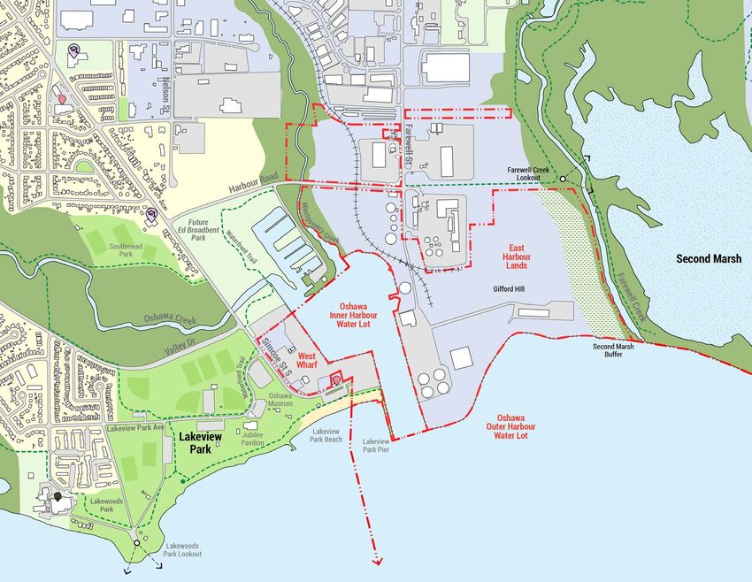
1.2 PORT HISTORY

Oshawa has long been a place for transportation                   Commission oversaw one of seven deep-sea ports
and trade, dating back to as early as the 1700’s                  in Canada until 2012 when it became the Oshawa
when the Mississaugas of Scugog Island First                      Port Authority. On June 18, 2019, The Oshawa
Nation used what is known today as the Scugog                     Port Authority became amalgamated with the
Carrying Place Trail. This trail, used for hunting                Hamilton Port Authority, and is known today as the
and trading, is one of several routes and carrying                Hamilton-Oshawa Port Authority (HOPA Ports)4.
places that connected the interior of the province                Still a hub for trade and transportation, the Port
to Lake Ontario1. First efforts to develop a                      of Oshawa recently posted its best season ever in
harbour were seen in 1840, when the Pier and                      2020, with tonnages exceeding 672,000 MT.
breakwaters were constructed by the Sydenham
Harbour Company. Exports at this time included
flour, pork, ashes, oatmeal, whisky and lumber.
Shipbuilding was also being done on the East Side
of the Harbour at this time. In 1878 the Sydenham
Harbour Company became known as the Oshawa
Harbour Company. Records indicate that by 1889
the harbour was exporting 16,337 tons of goods2.

The Harbour was the main method of shipping
for Oshawa during the Great Depression and the
Second World War. In 1930 the harbour continued
to expand with the opening of the Welland Ship
Canal, allowing larger ships to transit Lake Ontario
and increasing business at the Port of Oshawa3.
The St. Lawrence Seaway opened in 1959, and
soon after the Oshawa Harbour Commission
was created in 1960. The Oshawa Harbour

1. Oshawa Historical Society, The Scugog Carrying Place 2018
2. The Oshawa Museum, The Oshawa Harbour – Part 1 2020
3. Oshawa Historical Society, The Oshawa Harbour - Part II 2021
                                                                   View at Oshawa Harbour in 1900, credit the Thomas Bouckley Collection, Robert McLaughlin Gallery.
4. Oshawa Historical Society, The Oshawa Harbour - Part II 2021

4              THE PORT OF OSHAWA LAND USE PLAN
View of the Port in 1987 with the bulk carrier ship, the Kaptan Güven, docked, credit Oshawa Public Libraries, Local History Collection

                                                                                                                                          THE PORT OF OSHAWA LAND USE PLAN   5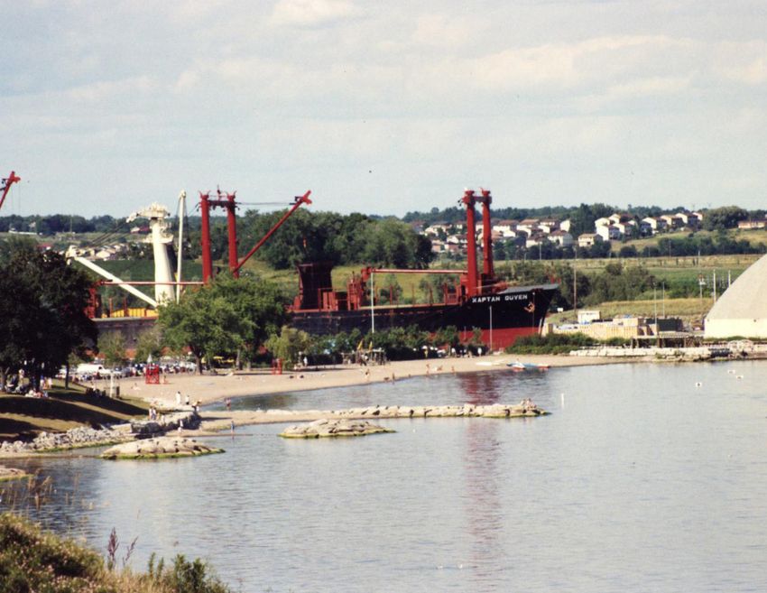
1.3 PORT LANDHOLDINGS

Oshawa is one of a few Canadian cities that can
boast an airport, rail lines, a deep water port and
400-series highways all within proximity to each
other. The combination of transportation facilities
provides importers and exporters in the city a
competitive advantage. The Port has access to a
workforce skilled in handling all types of cargo
and world markets through the St. Lawrence
Seaway.

The Port of Oshawa is one of the smallest ports
governed by a designated Canadian Port Authority
and includes 63 hectares (155 acres) of land lots,
206 hectares (509 acres) of water lots, and a 120
metre buffer from the Second Marsh. The Port
currently has 480 metres of dock wall, 2,000 sq.
metres of warehouse space, and 32,000 sq. metres
of open storage space, in addition to a grain
storage capacity of 10 tonnes. Located within the
Port of Oshawa are various features, including the
site of a previously relocated pioneer cemetery; a
pioneer homestead; an 18th century trading post;
and the landmark known as Gifford Hill.

                                                      Figure 1: Port of Oshawa within the St. Lawrence Seaway system

6          THE PORT OF OSHAWA LAND USE PLAN
Figure 2: Port of Oshawa within the context of the Greater Golden Horseshoe region Built-Up Area Highways Employment Lands The Port of Oshawa
Greenbelt Railways Lake Ontario Ports
THE PORT OF OSHAWA LAND USE PLAN 7Hamilton-Oshawa Port Authority
West Wharf 16.2 acres
East Harbour Lands 140.1 acres
Inner Harbour 34.4 acres
Outer Harbour 475.4 acres
Figure 3: Port of Oshawa landholdings in context
8 THE PORT OF OSHAWA LAND USE PLAN1.4 PORT GOVERNANCE
Canada Marine Act Letters Patent
The Canada Marine Act created CPAs to operate • Basing the marine infrastructure and HOPA’s Letters Patent establish the Port’s
particular ports on behalf of the Government services on international practices and governance framework, describing the navigable
of Canada. CPAs possess the power to engage approaches that are consistent with those of waters and property of HOPA, outlining the
in activities related to shipping, navigation, Canada’s trading partners in order to foster activities and powers of HOPA, and placing
transportation of passengers and goods, storage harmonization of standards; limits on borrowing, leasing and the activities of
and warehousing, and related activities. CPAs • Ensuring that marine transportation services subsidiaries.
are required to be financially self-sufficient. Port are organized to satisfy the needs of users and
are available at a reasonable cost; and, The Letters Patent establish that HOPA and its
authority operations are not funded by tax dollars,
subsidiaries do not access federal government
but through Port user rents and harbour dues. • Providing for a high level of safety and
funds except in special circumstances. HOPA is
environmental protection.
The Canada Marine Act is intended to facilitate required to pay an annual stipend to Transport
a National Ports System made up of 17 In accordance with the Act, each of the three Canada based on gross revenues. HOPA also
independently managed CPAs. The Act has a goal levels of government names an individual to the makes payments in lieu of taxes (PILT).
of facilitating efficient and viable Canadian ports, HOPA Board of Directors. The federal Transport
HOPA is also subject to other federal legislation,
which includes: Minister, on the recommendation of Port users,
including the Impact Assessment Act and
nominates four other Directors.
• Implementing transportation policies that its associated Regulations, and the Marine
provide Canada with marine infrastructure, Transportation Security Act and its Regulations,
offer effective support for the achievement which imposes a specific security regime for Port
of national, regional and local social and properties.
economic objectives, and promote and
safeguard Canada’s competitiveness and trade
objectives;
• Promoting the success of ports for
the purpose of contributing to the
competitiveness, growth and prosperity of the
Canadian economy;
THE PORT OF OSHAWA LAND USE PLAN 91.5 PROVINCIAL AND MUNICIPAL POLICY
A provincial and municipal policy framework
guides and regulates land use in the Greater
Golden Horseshoe region. As a federally-
designated and regulated port, land use and
Provincial Policy Statement (2020)
development at the Port of Oshawa are governed
by the federal legislature and the Letters Patent
described in Section 1.4, and guided by the Land The Provincial Policy Statement (PPS) provides The PPS establishes that planning authorities
Use Plan. Still, alignment of land use objectives policy direction on matters of provincial interest shall plan for, protect and preserve employment
at the Port with the broader land use planning related to land use planning and development. areas for current and future uses and ensure
framework is important; the broader community, The PPS sets the policy foundation for regulating that the necessary infrastructure is provided.
economy and environment stand to benefit when the development and use of land. Municipal The employment policies of the PPS require
the visions of the Port, the Region, City of Oshawa official plans must identify provincial interests the promotion of economic development and
and the community are mutually-supporting. and set out appropriate land use designations and competitiveness through the provision of a range
HOPA has regard for the planning policy policies, and municipal official plans and zoning of suitable sites for employment uses that can
framework in its land use planning processes and by-laws must be consistent with the PPS. support a wide range of economic activities taking
is committed to coordination and consultation into account the needs of existing and future
with municipal partners regarding the evolution businesses.
of the Port and the surrounding areas. The PPS also provides that planning authorities
shall protect employment areas in proximity to
major goods movement facilities and corridors
for employment uses that require those locations.
The PPS establishes that connectivity within and
among transportation systems is maintained, and,
where possible, improved. The PPS establishes
that a reliable multimodal transportation system
that supports the movement of goods and people
will ensure long-term economic prosperity. With
respect to marine and rail facilities, the PPS
requires that planning for land uses in their
vicinities must be undertaken to protect their
long-term operation and economic role.
Steel products at the East Harbour, with the grain terminal in the background
10 THE PORT OF OSHAWA LAND USE PLANGrowth Plan for the Greater Golden Greenbelt Plan
Horseshoe (2019) (2017)
A Place to Grow: The Growth Plan for the Greater The Growth Plan also identifies several The Greenbelt Plan (2017) protects natural areas,
Golden Horseshoe (the Growth Plan) was released Provincially Significant Employment Zones (PSEZs) agricultural lands and water resources in the
on May 15, 2019, with Amendment 1 brought into in the region. The entirety of the Port of Oshawa Greater Golden Horseshoe region. The Greenbelt
effect August 2020, replacing the 2017 Growth lands function as employment lands, and most Plan provides permanent protection to the
Plan under the terms of the Places to Grow Act, of the lands are within a Provincially Significant agricultural land base and the ecological and
2005. The Growth Plan provides a framework Employment Zone. Like all municipally-designated hydrological features, areas and functions. Oshawa
for growth management across the region in Employment Areas, Provincially Significant Creek, Harmony Creek, Farewell Creek and the
coordination with the policies of the Greenbelt Employment Zones are considered to be long- Second Marsh, adjacent to the Port, are external
Plan, the Oak Ridges Moraine Conservation Plan, term, stable employment areas, but unlike other connections of the Greenbelt’s Natural Heritage
and the Niagara Escarpment Plan. Employment Areas, they cannot be converted System. Oshawa Creek and Farewell Creek are
to other land uses in advance of a Municipal designated Urban River Valleys. Urban River
A guiding principle of the Growth Plan is to Comprehensive Review. As shown in Figure 4, a Valleys provide important linkages between the
provide flexibility in the region to capitalize on large portion of Durham Region’s waterfront along Greenbelt and Lake Ontario.
new economic and employment opportunities the 401 corridor is employment focused.
as they emerge, while providing certainty for
traditional industries. The Growth Plan establishes The Growth Plan policies for Employment Areas
employment growth forecasts and intensification and PSEZs align with HOPA’s mandate to support
targets for employment and requires that goods movement and economic development
municipalities supply adequate land within through the long-term management and
employment areas to meet those targets and stewardship of its Port of Oshawa lands.
to accommodate a broad range of employment
uses. Municipalities are required to designate and
preserve lands adjacent to or near major goods
movement facilities and corridors, including major
highway interchanges, as areas for manufacturing,
warehousing and logistics, and to prohibit
residential and sensitive land uses.
THE PORT OF OSHAWA LAND USE PLAN 1133
26
Oshawa
Thickson Rd
Dundas St
Stevenson Rd
King St 2
Harmony Rd
Ritson Rd
Whitby
Clarington
Bloor St
401 Bloor St
418
Farewell St
Courtice Rd
Si
m
co
401
eSt
Lake Ontario
Figure 4: The entirety of the port lands is a long standing employment area, most of which is also Port of Oshawa Railways Provincially Significant
a Provincially Significant Employment Zone identified in the Growth Plan (Source: Ministry of Employments Zones (PSEZ)
Built-Up Area Municipal Boundaries
Municipal Affairs, modified by Urban Strategies) 120m buffer from Second Marsh
Greenbelt Highways
Major Roads
12 THE PORT OF OSHAWA LAND USE PLANDurham Regional Oshawa
Official Plan Official Plan
The current Durham Regional Official Plan The Minister of Municipal Affairs and Housing and recreation uses that align with the HOPA’s
(Regional Official Plan) was adopted by Regional approved the City of Oshawa Official Plan commitment to buffer from and support the
Council in 1991 and approved by the Minister of (Oshawa Official Plan) on February 12, 1987. The conservation of the Second Marsh.
Municipal Affairs and Housing in 1993. The current Oshawa Official Plan was last consolidated in
September 2019. The Oshawa Official Plan directs The Open Space and Recreation designation
consolidation includes amendments to May 11th,
land uses on City-wide basis with supporting aligns with HOPA’s on-going provision of public
2017. The Plan guides growth and development in
policies on environmental management, access to its Beach and Pier lands for public
the Regional Municipality of Durham by providing
transportation, infrastructure and community recreation.
policies for improving and securing the quality of
life, health, safety, convenience and well-being of improvement.
The Oshawa Official Plan also indicates a
present and future residents. The Regional Official municipal intention to foster a Tourist Node and
The Oshawa Official Plan identifies land
Plan aims to develop the Region to its economic Recreational Node on the West Wharf lands, and a
use designations for the Port lands east of
potential and increase job opportunities for its potential Marina Node north of the Inner Harbour,
Montgomery Creek as Industrial and Special
residents. south of Harbour Road.
Waterfront Area. The Special Waterfront Area
The Regional Official Plan designates the majority Policy is applied to the Port and the surrounding
The Oshawa Official Plan identifies much of the
of the Port of Oshawa lands as Employment Areas area. Port lands west of Montgomery Creek
Port of Oshawa lands and lands to the north of
while the West Wharf is designated as Waterfront are designated Open Space and Recreation,
the West Wharf as an Oshawa Harbour Special
Areas. Lands surrounding the Port of Oshawa with indication of a potential Recreation Node.
Development Area. The related policies encourage
are designated as Employment Areas, Waterfront Surrounding lands include a mix of Industrial,
economic development of the Special Policy Area,
Areas, and Living Areas. Recreational and Open Space and Recreation
to be achieved through a mix of development in
lands.
line with the municipal Land Use Plan. Develop
The Regional Official Plan Employment Areas
There are significant areas of alignment in the area is also to reflect principles of good
designation is consistent with the existing uses
between the Official Plan land use designations design, including adaptability over time, climate
and long-term vision of the Port. The permitted
and the Port’s existing and planned functions. change resiliency, respect for, and integration with,
uses for Employment Areas are expansive and
The Industrial land use designation supports natural features and functions, and long-term
include manufacturing, warehousing, storage
warehousing and storage, utility functions and sustainability.
of goods and materials, freight transfer and
transportation facilities. The Regional Official Plan transportation terminals. The Special Waterfront
encourages Employment Areas near the Oshawa Area designation—which is applied to the
Harbour to be reserved for industries that benefit eastern portions of the Port lands—encourages
from locating in proximity to such land uses. industrial and office uses, as well as open space
THE PORT OF OSHAWA LAND USE PLAN 13Zoning Settlement Land Use and
Agreement Municipal Services
Municipal zoning by-laws regulate the permitted On April 22, 2010 Oshawa City Council approved
Agreement
uses as well as built form and other characteristics a Settlement Agreement between the Federal
for development. The City of Oshawa Zoning By- Crown, Oshawa Harbour Commission and the A Land Use and Municipal Services Agreement
law 60-94 regulates land use and development City with respect to a number of matters. The exists between the Port and the City of Oshawa
city-wide, including in the Port’s context area. Agreement included the conveyance of 19.4 as of July 2010. Key elements of this agreement
hectares of land to the City, including the former remain in force, including a framework to
By-law 60-94 applies a variety of zoning marina lands. Implementation of the Settlement cooperate and consult on matters related to land
categories to the Port and surrounding area. There Agreement aimed to achieve a balanced use of the use, land development and municipal services in
are five zone categories in this area that permit a Oshawa Harbour area. The Agreement allowed for the harbour area. Specific guidance is provided
variety of industrial uses and activities: Harbour the City to proceed with elements of their vision on land uses on the West Wharf, protection of the
Commercial Zone HBC T12; Special Industrial for certain lands at the Oshawa Harbour, but also Second Marsh, and the appropriate use of dredged
Zone; Special Waterfront Zone; Select Industrial enabled the optimization of short and long-term material.
Zone SI-A(3); and Select Industrial Zone SI-B. The economic benefits to the City and Durham Region
120m Second Marsh buffer zone is zoned Open from the Oshawa Harbour lands.
Space Buffer. This zoning permits an earthen
berm, flood and erosion control structures, storm
drainage control facilities, and educational uses
for the enjoyment of a natural area.
14 THE PORT OF OSHAWA LAND USE PLANBird’s eye view of the Port of Oshawa and its context
THE PORT OF OSHAWA LAND USE PLAN 1516 THE PORT OF OSHAWA LAND USE PLAN
Plan
Update
Process   THE PORT OF OSHAWA LAND USE PLAN   17
2.1 CHANGING ENVIRONMENT

The operating environment that formed the basis
for the previous 2013 Land Use Plan has changed
significantly:

•    The Oshawa Port Authority and the Hamilton
     Port Authority were amalgamated in 2019.
     The amalgamated Hamilton-Oshawa Port
     Authority is positioned to better attract
     investment, develop the supply chain and
     enhance the region’s global connectivity and
     competitiveness.
•    HOPA purchased the long-vacant Petrocor
     property on the West Wharf and in August
     2020 began demolition of the six rusting
     fuel tanks located there. The tanks, which
     remained unused on the vacant Petrocor site
     for many years, were considered an eyesore
     for the community. Removal of the tanks
     improves the visual appearance of the area,
     which includes Lakeview Park, and represents
     an important step in improving the Port-City
     lands interface.
•    The Oshawa waterfront has evolved with
     investments in Lakeview Park and the
     renaming of Ed Broadbent Waterfront Park.
     The completion of the Public Art Master
     Plan in 2018 identified the waterfront as
     a key area for public art activation. In the
     summer of 2021, the City will have completed   The interface between the Port and public areas has been improved as a result of the removal of the Pretocor
     the redevelopment of the splash pad and        tanks on Simcoe Street
     playground at Lakeview Park.

18         THE PORT OF OSHAWA LAND USE PLAN
2.2 COMMUNITY ENGAGEMENT
AND CONSULTATION
The Land Use Plan recognizes that the Port of Through surveys, targeted stakeholder interviews
Oshawa is a regional economic asset and plays a and a virtual open house, HOPA received input
role in the local community fabric. The planning from approximately 200 people from the local
process included opportunities for input from community, stakeholder groups, First Nations
local stakeholders and the broader community on communities, and Port users. The following is
how to maximize the Port’s economic contribution, a summary of some of the key themes heard
while contributing to a healthy, vibrant waterfront, through the engagement process:
city and region. HOPA will be entering into a
Communication and Cooperation Strategy with the • Continue to build relationships with the
City of Oshawa. community;
• Protect the Second Marsh and surrounding
environmental areas;
• Mitigate visual and noise impacts from the
West Wharf;
• Balance the recreational and industrial
activities of the waterfront;
• Maintain a focus on environmental
stewardship;
• Enhance economic activity and employment;
• Improve access and make better use of
underutilized space;
• Use signage to inform and create interest in
the role of the Port;
• Continue to diversify cargo and Port users;
• Establish a common vision for the Oshawa
waterfront; and
• Grow the role of the Port in Durham Region.
THE PORT OF OSHAWA LAND USE PLAN 1920 THE PORT OF OSHAWA LAND USE PLAN
Port
Context   THE PORT OF OSHAWA LAND USE PLAN   21
3.1 REGIONAL CONTEXT

The Port is focused on delivering modal choice,                       As the economy grows, the demand for                                  The Region of Durham is looking to grow their
efficiency and competitiveness to Port users,                         transportation-intensive employment space is                          six key industries: agri-business, EN3 (energy,
helping Ontario industries thrive. The Port of                        expected to continue to expand. The Region of                         environment & engineering), health sciences,
Oshawa is Durham Region’s largest Port and                            Durham is well-positioned to meet those demands                       innovative technology, manufacturing and
is an important component of the Region’s                             east of Toronto, with space and opportunity to                        tourism. The Port of Oshawa can play a role in
transportation system and economy. Today, the                         grow its transportation and logistics sector. The                     supporting the growth of many of these industries.
population of the Region is just over 697,000                         preservation of appropriate space for industry and                    In particular, the Port will continue to be a vital
people and the Growth Plan forecasts that                             manufacturing is necessary to ensure the region’s                     link between the Region’s agricultural producers
Durham Region will grow to 1,300,000 people in                        economic diversity in the coming decades. The                         and their markets, and will be an essential link in
2051. There are currently 239,000 jobs in Durham,                     transportation-intensive nature of these functions                    the supply chain for commodities, materials, and
with the Growth Plan projecting an increase to                        makes the Port of Oshawa a logical hub for                            specialized manufacturing products.
460,000 jobs in 2051.                                                 continued marine-industrial employment uses.

The Port of Oshawa supports the movement of key industry exports and inputs, including grain, construction materials, and advanced manufacturing components.

22            THE PORT OF OSHAWA LAND USE PLAN
t ri   c t o n n e s of g r a i
                                                                                                                                           n   me                                   np
                                                                                                                                                                                         ro
                                                                                                                                 il   li o                                                    du

                                                                                                                                                                               m
                                                                                                                            m

                                                                                                                                                                                               ct
                                                                                                                                                                            0k

                                                                                                                                                                                                   io
                                                                                                                          1. 4

                                                                                                                                                                          15

                                                                                                                                                                                                    nw
                                                                                                                                                                                                       it h i
                                                                                                                                                                                                    n 150 km of the
                                                                                                                                                     Port of Oshawa
                                                                                                                                           Port of Hamilton

                                                                                                                                                                                                                    Po
                                                                                                                                                                                                    t                  r
                407
                                                                                                       407
                                                          412

    Pickering
                                                                                                                                           Clarington
                                                                                      Oshawa                                                                             115

                                  Ajax                           Whitby                                      418

                                           401

                                                                                                                      401

                                                                                      Port of Oshawa

                                                                          Lake Ontario

Figure 8: Major drivers of economic development within Durham Region          Built-Up Area        Employment Lands                    Highways                                Nuclear Plants
                                                                              Greenbelt and        Urban Growth Centres                Major Roads                             Airports
                                                                              agricultural areas
                                                                                                                                       Railways                                General Motors Plant
                                                                              Oak Ridges Moraine
                                                                                                                                       Municipal Boundaries

                                                                                                                             THE PORT OF OSHAWA LAND USE PLAN                                  23
3.2 SURROUNDING CONTEXT
The Oshawa Waterfront & Adjacent Employment Lands
The Oshawa waterfront contains extensive Lakeview Park and the Oshawa Museum contain THE SECOND MARSH
parkland, residential communities, major natural the Port of Oshawa Pioneer Cemetery relocated
Oshawa’s Second Marsh is 137 hectares of
features and the Port of Oshawa. from the Port lands.
provincially significant coastal wetland, located
To the west and north of the Port of Oshawa Oshawa Creek and Montgomery Creek both outfall east of the Port of Oshawa, that provides habitat
is a connected system of public open spaces. into the inner harbour at the Port. Oshawa Creek for wetland dependent wildlife. The combination
These include Lakeview Park, Southmead Park, flows 50km from its starting point in the Oak of the Second Marsh with the adjacent areas
Lakewoods Park, Stone Street Park, the future Ed Ridges Moraine. Montgomery Creek is a tributary of the McLaughlin Bay Wildlife Reserve and
Broadbent Park, Oshawa Valleylands Conservation of the Oshawa Creek. The areas along both the Darlington Provincial Park represents nearly
Area, the Larry Ladd Harbour Trail, Lakeview Oshawa Creek and Montgomery Creek have trails 400 hectares of publicly accessible natural areas,
Park Beach, Oshawa Creek and Montgomery for public usage. adjacent to the waterfront. The Second Marsh
Creek. While the Port of Oshawa sits within the is known as important breeding and migratory
continuous network of parks along the waterfront, West of Lakeview Park is the Lakeview residential stopover area for birds and contains a diversity of
it has the ability to integrate alongside and neighbourhood. The Lakeview neighbourhood natural and constructed features including a range
support connectivity between waterfront places. stretches as far west as Boundary Road, north of vegetation types, a beach, Harmony/Farewell
to the 401 Highway, east to the Second Marsh Creek, an earthen dike and upland vegetation
Lakeview Park, the Oshawa Museum and Ed and south to Lake Ontario. Closer to the lake are communities. A 120m wide open space buffer on
Broadbent Park are important community assets detached homes with some small scale apartment the Port lands adjacent the west side of the marsh
to the City. The Oshawa Museum preserves and buildings further north closer to the 401 Highway. helps to ensure adequate protection of the Second
promotes awareness and appreciation of Oshawa’s The Lakeview community contains three secondary Marsh from adjacent port-related uses.
history. Lakeview Park is the most actively used schools, five elementary schools, and numerous
among all of Oshawa’s waterfront parks and recreational facilities. The Oshawa GO station is As outlined in the policies of Section 6 and 7
is consistently used for City-wide celebrations located at the western boundary of the Lakeview of this report, HOPA is committed to protecting
and events. Lakeview Park is classified as a neighbourhood. and maintaining the Second Marsh buffer lands.
“Destination Park” within the City of Oshawa The buffer lands will remain in HOPA’s secure
for its ability to offer facilities and attractions To the north of the Port of Oshawa are perimeter and not be publicly accessible.
not found in other parks. Including the Jubilee complementary employment uses. This includes
Pavilion, Lakeview Park contains four heritage a McAsphalt terminal directly adjacent to the
buildings. The Oshawa Museum is comprised site located at the intersection of Farewell Street
of three historic homes: Henry House, Robinson and Harbour Road. The employment area is
House and Guy House. Henry House was lived characterized by 1-storey commercial buildings,
in by Thomas Henry, the former President of the some containing open storage. The area includes
Oshawa Harbour Company. industrial, manufacturing, commercial and
logistics uses.
24 THE PORT OF OSHAWA LAND USE PLAN8
5
10
12
9 11
6
7
4
2 3
Legend
1 Environmental Areas HOPA Lands
Parkland Railway
Other Green Spaces Trails
Residential Uses Schools
Employment Uses Water Treatment Facilities
Local Retail
Figure 9: The Port of Oshawa in its immediate context
THE PORT OF OSHAWA LAND USE PLAN 251 Lakeview Park is the jewel of Oshawa’s waterfront 2 The eastern portion of Lakeview Park Beach is owned 3 Owned by HOPA, with access provided via agreement with
and hosts many city-wide events. by HOPA, the western portion is owned by the City of the City of Oshawa, the Lakeview Park Pier provides views of
Oshawa. Lake Ontario.
4 Oshawa Creek flows into the inner harbour of the Port. 5 A diverse range of employment and industrial uses exists 6 The future Ed Broadbent Waterfront Park will expand public
north of the Port. access to the waterfront with new programming on lands
northwest of the inner harbour, with connections to the
Harbour Trail.
26 THE PORT OF OSHAWA LAND USE PLAN7 The City-owned former marina lands are located 8 Complementary employment uses front onto Farewell Street. 9 Harbour Road connects the West Wharf with the East
within the inner harbour. Harbour for vehicles and is an important cycling
connection along the Waterfront Trail.
10 The intersection of Harbour Road and Farewell Street is a 11 The Waterfront Trail passes alongside the East Harbour 12 The Second Marsh contains 137 ha of provincially
key gateway for the Port and the surrounding employment lands and connects to the Second Marsh. significant coastal wetlands.
area, and for people accessing the waterfront and natural
areas. Safely balancing truck, car and cycling activity here is
critical.
THE PORT OF OSHAWA LAND USE PLAN 2728 THE PORT OF OSHAWA LAND USE PLAN
The Port’s
Role         THE PORT OF OSHAWA LAND USE PLAN   29
4.1 CARGO FLOWS AND SHIPPING

The Port of Oshawa is Durham Region’s gateway            The Port of Oshawa is an integrated multimodal          Infrastructure requirements include:
to global markets, and the eastern transportation        facility with potential to increase the amount of
                                                                                                                 •   Dredging of the east berth and approach
bookend to the Greater Toronto Area. In 2020,            cargo that transloads between marine, rail and
                                                                                                                     channel;
the Port of Oshawa handled its highest volume            truck transportation. The port offers shippers a full
of cargo ever: 672,100 MT, aboard 77 domestic            suite of facilities and services, including terminals   •   Construction of east approach channel spit;
and international vessels. The Port’s annual             for dry and liquid bulk and breakbulk commodities,      •   Navigation and dock lighting;
cargo has a value of approximately $260 million,         stevedoring operations with heavy lift capacity,        •   Extension of the east berth;
supporting economic activity and employment in           and storage capability. The port has 32,000 sq.         •   Rehabilitation/resurfacing of the east and
the agricultural, construction and manufacturing         metres of open outdoor storage; 20,160 sq. metres           west wharves;
sectors.                                                 of indoor storage across several indoor storage         •   Upgrading the access road and utilities;
                                                         facilities; 480 meters of dockwall and access to
The commodities handled by the Port of Oshawa                                                                    •   Demolishing the obsolete storage shed on
                                                         Class 1 rail.
include: fertilizer, grain, general cargo, liquid bulk                                                               West Wharf to create additional cargo lands;
products, petroleum products including liquid            HOPA ensures ongoing investments are made               •   Surfacing and stormwater management
asphalt, salt, steel and cement.                         in major port infrastructure and maintenance,               infrastructure for reduced dust and improved
                                                         including dredging and dockwall maintenance, to             storm water management;
The Port of Oshawa connects Canada with global           ensure efficient vessel service, and the ongoing        •   Improving gates and fencing for greater
markets including the United States, Europe, and         functionality of the port lands. HOPA is also               security;
the Middle East.                                         responsible for maintaining interior roads, utilities   •   Creating a consolidated site office;
                                                         and shared facilities on the land side.                 •   Perimeter landscaping and screening
Together with the Port’s stevedoring partner, QSL,
HOPA Ports has established a target to achieve 1                                                                     improvements.
                                                         HOPA has identified more than $25 million
million MT of cargo through the Port of Oshawa.          in infrastructure requirements at the Port of           HOPA continues to refine its infrastructure
Much of this growth is anticipated to come from          Oshawa, to be prioritized and implemented over          priorities, based on a developing understanding of
increased capacity to facilitate Ontario grain           several years. Of these, $15 million in identified      the site, and the needs of current and future Port
exports, for which there is established demand.          infrastructure investments are directly related to      users.
                                                         the Port’s future ability to accommodate export
                                                         growth for Ontario-grown grain.

30          THE PORT OF OSHAWA LAND USE PLAN
70-80 $260 672,100
vessels/year million/year MT of cargo
On average, the Port of On average, $260 million In 2020, the highest
Oshawa handles around worth of cargo per year volume of cargo ever was
70-80 vessels per year. transits the Port, from handled through the Port
salt and steel products to of Oshawa.
asphalt and grain.
THE PORT OF OSHAWA LAND USE PLAN 314.2 CURRENT ACTIVITIES AND
PORT USERS
Approximately 11 Port users and partners from a WAREHOUSING, SHIPPING AND
diverse set of industries currently operate within DISTRIBUTION
the Port of Oshawa. Some users have been at
the Port for many years, but the Port continues
to attract new users. Generally, users within the
The Warehouse, Shipping & Distribution category
includes those businesses involved in product
GRAINS
trans-loading between different transport modes
Port of Oshawa fall within the following six broad
(marine, rail, and/or road) as well as the storage of
categories:
products ranging from steel to consumer goods.
AGRI-FOOD
The Agri-Food category includes those businesses
DRY BULK
Includes industries handling commodities such as
STEEL
salt, potash and aggregates.
related to the transportation and processing of
agricultural products, including grain export and
fertilizer terminals.
ROAD SALT
RECREATIONAL USES
BULK/BREAK-BULK The former marina lands at the north end of the
harbour are owned by the City of Oshawa. HOPA
The Bulk/Break-Bulk category includes the storage recognizes the ongoing desire of the City and
and trans-loading of loose bulk and individual other stakeholders to reintroduce marina and/
products, including finished steel slabs, beams, and or boat launch facilities to the harbour. Concerns
coils, as well as larger manufactured components
and equipment imported or exported on behalf of
the region’s manufacturing sector.
do exist related to the safety of recreational
vessels interacting with commercial vessels ASPHALT
in an increasingly busy harbour, but HOPA has
committed to working with the City to finding
LIQUID BULK
an approach that will meet its objective to
The Liquid Bulk category includes those industries accommodate more recreational use.
and businesses involved with the transport
and storage of liquid materials, including liquid
asphalt.
POTASH
Significant goods and materials that move through the Port.
32 THE PORT OF OSHAWA LAND USE PLAN4.3 FUTURE ECONOMIC OPPORTUNITIES
HOPA staff have conducted an assessment of the export inventory could not be accommodated by
market opportunities suited for development southern Ontario’s transportation system today.
at the port of Oshawa. In consultation with The GTA-east is the best place to add capacity to
regional economic development partners, HOPA maximize system efficiency and meet growing
has identified several sectors with high potential demand, with 300,000MT/yr of the anticipated
for future growth. These include, but are not Ontario grain production increase coming from
limited to: structural steel products for the the Port of Oshawa catchment. Building new
GTHA construction market; other construction export capacity, the Port of Oshawa could grow
commodities such as cement and gypsum; cement export to 200,000-300,000 MT per year, from the
pre-cast fabrication; heavy manufactured goods current 75,000 MT.
and/or components associated with automotive
manufacturing; energy sector vessels or factory As part of an integrated port network on the Great
components; liquid bulk commodities such as Lakes, early-stage analysis also suggests future
gasoline and food oils; fertilizer; food processing opportunity for the port of Oshawa as a key node
such as flour milling or sugar refining; and bulk in a Great Lakes short sea shipping network,
or specialty grain; salt import and blending; moving construction materials or consumer goods
warehousing. HOPA has determined that an within the Great Lakes basin on a just-in-time
ethanol refinery will not be considered as a port basis.
use.
HOPA has determined that given all of these
HOPA has conducted a detailed analysis of the potential market demands, that all port lands
potential demand for grain export capacity. This currently used for employment uses should
study revealed Ontario export grain production is continue as employment lands over the time
expected to grow from approx. 4m MT today to 6m horizon of this Land Use Plan.
MT by 2029. The additional expected Ontario grain
THE PORT OF OSHAWA LAND USE PLAN 3334 THE PORT OF OSHAWA LAND USE PLAN
Mission and
Land Use
Principles    THE PORT OF OSHAWA LAND USE PLAN   35
5.1 MISSION & VISION

HOPA’S OVERARCHING MISSION                  HOPA’S VISION:
FOR THE PORT OF OSHAWA:

We are responsible stewards of the port     Create and lead
lands and their robust marine, road and     an integrated port
rail networks. We create prosperity by      network on the Great
facilitating commerce and providing         Lakes.
sustainable solutions that offer value to
our port customers and benefit to our
communities.

36   THE PORT OF OSHAWA LAND USE PLAN
5.2 LAND USE PRINCIPLES

Seven interrelated principles guide HOPA in its Port of Oshawa planning processes, providing direction
for growth and development of the Port over time. These principles are:

    1. Economic Development                               3. Environment                                 6. Partnerships
    Ensure the economic vitality of the Port              Recognize the position of the Port within      Align with the efforts of the region, the
    of Oshawa over the long-term. Grow the                a confluence of environmental areas and        municipality, agencies, and the community
    role of the Port in Oshawa’s manufacturing            work with stakeholders in government           in ongoing economic development and
    sector and Durham Region’s agricultural               and the community to protect and manage        planning initiatives.
    sector.                                               sensitive areas.

                                                                                                         7. Engagement
    2. Balance                                            4. Sustainability                              Strengthen relationships with the public,
    The Port is an important part of Oshawa’s             Promote environmental safety, social           First Nations communities, and other
    waterfront, located within a system of                and economic sustainability in decision-       stakeholders to provide awareness on
    public parks and natural areas. Ensure                making processes concerning land uses          HOPA’s role, share information about
    the management of the port and its uses               and new buildings, new infrastructure and      development possibilities, and collaborate
    balance the function and needs of the Port            improvements, and Port user operations.        on shared goals.
    and its waterfront relationships.

                                                          5. Image
                                                          Oshawa prides itself as a waterfront
                                                          City. Recognize the high visibility and
                                                          relationship of the Port to waterfront areas
                                                          and seek to improve the physical image
                                                          and interface of the Port lands with its
                                                          surroundings.

                                                                                                            THE PORT OF OSHAWA LAND USE PLAN          37
38 THE PORT OF OSHAWA LAND USE PLAN
Development
Considerations
This section details the Land Use Plan policies that will direct HOPA’s management and
development activities. These general directions are meant to be read in conjunction with the
area-specific directions of Section 7 as well as the implementation considerations of Section 8.

                                                                                                   THE PORT OF OSHAWA LAND USE PLAN   39
6.1 MULTIMODAL CONNECTIVITY
Port as a Multimodal Hub
Canada’s ports serve the national and regional GTHA highways is causing delays and increased
economic interest by providing efficient costs. Better utilization of marine facilities for
goods movement, regardless of the mode of goods movement in Ontario can reduce the
transportation. amount of trucks and congestion on roads.
The Port of Oshawa is a crucial transportation Growing the role of marine shipping in Ontario
hub to bring in materials for the region’s will allow transportation users to benefit from
construction industries, such as cement, steel and modal choice, choosing marine or surface shipping
asphalt. The GTHA is now the fastest growing when it makes sense. HOPA benefits from being
metropolitan region in North America. Given able to provide marine, rail and truck shipping
the contracting role of the Port of Toronto to options, as well as efficient connections between
handle core commodities for population-driven those modes.
infrastructure development, the Port of Oshawa
can play a greater role in servicing this market. As Multimodal hubs require a large amount of
the GTHA continues to grow and develop, the Port industrial and logistics space. While not all of
of Oshawa can play a critical role in making that the Port of Oshawa has direct water access, all
happen. parcels provide rail availability and/or road access.
The operation of marine sites is within HOPA’s
Ships are an important component of goods mandate, and site users requiring marine access
movement and supply chains, but are always will be afforded access to a dockwall, or access to
linked with surface transport methods. Almost all vessels via pipeline. HOPA often structures tenancy
goods being moved by ship either arrive or depart agreements to allow for multi-user access to the
by truck or rail. Increasingly, congestion along Port’s dockwalls.
40 THE PORT OF OSHAWA LAND USE PLANRossland Rd 28
33
26
Oshawa
Thickson Rd
Stevenson Rd
Dundas St
Harmony Rd
King St 2
Ritson Rd
Brock St
Whitby Clarington
401 Bloor St
401 22
Bloor St
Bloor St
Farewell St
Victoria St 22 418
56
Courtice Rd
Si
m
401
co
e
St
Port of Oshawa
Lake Ontario
Figure 10: The Transportation Network Supporting the Port of Oshawa Built-Up Area Arterial Roads
Greenbelt Durham Region Strategic Goods Movement Network
HOPA Lands Durham Region Proposed Additions to Goods
Movement Network
Full Interchange
Railways
Partial Interchange
Municipal Boundaries
Airport
THE PORT OF OSHAWA LAND USE PLAN 41Marine Trucking Rail
Investments and improvements to the Port’s The Port of Oshawa has excellent road In 2015, CN opened a rail spur in the Port of
wharves, dockwalls, approach channel and connections. It is directly connected to Farewell Oshawa. The rail spur leads up to the Kingston
inner harbour are required to increase their Street (which is part of the Durham Region subdivision, a major rail corridor connecting
functionality. Strategic Goods Movement Network). The Port Toronto to Montreal. Integration of rail with
is also linked to Simcoe Street via Harbour marine and truck shipping can expand import and
On the East Wharf, the north end of the dockwall Road. Roads providing connections to the Port export opportunities in the Port.
requires extending to increase loading and are managed and maintained by the Region of
unloading capacity. Durham and the City of Oshawa. HOPA will work To access the East Harbour lands, rail cars must
with all parties to ensure these goods movement pass through a sliding security gate. There are
On the West Wharf, resurfacing and improved corridors maintain their important role in the two security gates for the rail to pass through on
stormwater management measures are required to network. HOPA’s property while crossing Harbour Road.
mitigate flooding on the dock. Improved lighting Active transportation routes on Harbour Road
is also required on the West Wharf. Efficient access to the Port by road is important must have safety considerations for crossing
for local agriculture producers, but some the rail tracks. Rail service may be extended
This will allow for the berthing of two vessels, and improvements are required. There are 278 grain southward to provide direct access to future
greater ability to shift vessels at berth for efficient and oilseed farms in Durham Region that rely on developments. Better integration of the Port’s rail
loading of all holds. Port users from the shipping the Port of Oshawa to help them expand their infrastructure with user operations is expected to
community identified navigation and operational operations. These farms are located north of the increase the use of this asset in support of cargo
lighting as key areas for improvement, along highway, and currently a common route for trucks growth over the time frame of this plan.
with dredging and elimination of obstacles to carrying grain is down Simcoe Street South to
shipping in the approach channel. Together, these Harbour Road. This route is currently constrained,
improvements will allow the port to increase its passing through both residential and industrial
daily operating hours along with improvements to areas and staging of up to twenty waiting
safety. trucks can occur on Harbour Road which creates
conflicts with pedestrians and cyclists. There is
an opportunity to direct more trucks to Farewell
Street, which is better suited for truck traffic.
HOPA seeks to work with Durham Region and the
City of Oshawa to advocate for improvements to
highway interchanges and the provincial goods
movement network that would accelerate this
shift in traffic flows. Improvements to the road
access and interior staging are intended to make
traffic flow more safe and more efficient.
42 THE PORT OF OSHAWA LAND USE PLANDredging
The dredging of the East Berth and approach
channel will greatly improve the usability of the
berth, and improve access to the Port of Oshawa
by investing in dredging, lighting, stormwater
management, dockwall extension and other
infrastructure upgrades, HOPA will remedy areas
of critical capacity underutilization.
Port Authorities in the Great Lakes are required to
conduct maintenance dredging to ‘Seaway depth’
of 8.2 m (27 ft.) ensure vessel access to port. The
Port of Oshawa experiences a high degree of
siltation resulting in the need for annual dredging
at the mouth of the harbour and in the approach
channel.
The majority of siltation is caused by lateral and
northward movement of clean sand from Lake
Ontario. Some siltation is also caused by deposits
from the outflows of Montgomery and Oshawa
Creeks, resulting in the need for dredging in the
inner harbour, albeit less frequently.
Dredged material is tested to determine
appropriate management options. Sediment that
meets applicable criteria may be re-deposited
locally within Lake Ontario. Other dredged
material may be used to create usable land
extensions within a confined disposal area. Two
areas for potential confined disposal are identified
in Figure 12. Dried sediment has also been reused Yearly maintenance of dredging the approach channel ensures Port operations run smoothly.
onsite to create a berm, and may be subject to
offsite reuse or disposal.
THE PORT OF OSHAWA LAND USE PLAN 436.2 URBAN DESIGN
The Port of Oshawa is in a high profile location Urban design enhancements will be considered
on Oshawa’s waterfront and includes 63 ha and implemented primarily as new Port user-
(155 acres) of land interfacing with a variety of driven development or site preparation occurs,
recreational, natural, and industrial contexts. but also as the Port initiates broader site or
infrastructure improvements. The colour, materials,
Urban design can play a role in connecting the design and placement on the site of buildings and
broader Oshawa waterfront. Improved pedestrian structures will be considered in how they add to
and cycling networks between Lakeview Park the visual quality of the Port.
and the Second Marsh will make an important
contribution to the continuity and experience of
the waterfront. This includes actively cooperating
with the City of Oshawa to facilitate a relocated
multi-use path on the east-west strip of land
that is currently owned by the port authority.
HOPA will explore opportunities to enhance this
connectivity and improve urban design where
the port interfaces with the public realm to
improve accessibility, contribute to the character
of waterfront areas, and/or support land use
compatibility. At key locations on the Port lands,
additional interpretive signage may be employed
to inform the community on the role of the Port
and the history of the area.
HOPA will aim to create a high standard of urban
design for its assets. The quality and character
of the urban design will celebrate the industrial
and employment nature of the Port. Special
consideration for urban design will be taken for
the West Wharf to complement its interface with
community and recreational uses.
Urban design can play a role in connecting the
broader Oshawa waterfront. Improved pedestrian
and cycling networks between Lakeview Park
and the Second Marsh will make an important
contribution to the continuity and experience of the
waterfront.
44 THE PORT OF OSHAWA LAND USE PLAN6.3 PUBLIC USES AND PROTECTED
NATURAL SPACES
HOPA will continue to encourage and accommodate, as appropriate, a balance between commercial and
recreational uses on the waterfront.
WEST WHARF in identifying a potential location for this facility.
Any potential public boat launch locations on
HOPA is supportive of the City’s investment and
Port lands would be evaluated with regard to
initiatives to create a cohesive waterfront in
safety and the ability to maintain efficient Port
Oshawa. Opportunities for improved landscaping,
operations.
screening, connectivity, and interpretive signage
where the West Wharf interfaces with the Oshawa NATURAL SPACES
waterfront will enhance the image and user
enjoyment of Oshawa’s waterfront areas. Special The Second Marsh buffer zone, the riparian edges
consideration will be taken during the approval of Montgomery Creek, the provincially significant
of any potential Port users at the West Wharf and wetland surrounding the creek north of Harbour
their proposed activities and structures. Road, and Gifford Hill are all recognized as
important natural spaces within the Port’s secure
Within the West Wharf, two parts of the boundaries, representing the natural and cultural
waterfront, the Pier and a portion of Lakeview heritage of Oshawa.
Beach, are experienced as the public realm
but are under HOPA’s management. HOPA will These natural areas will enjoy special attention
continue to maintain public access to these areas and protection, with limitations on development.
and will work with the City of Oshawa to align Some uses, such as walkways, beekeeping
any enhancements so that the waterfront area is colonies, and stormwater infrastructure may be
experienced as a cohesive public area. permitted, in particular in alignment with the
municipal zoning related to the marsh buffer. The
RECREATIONAL BOATING height and upper vegetation of Gifford Hill will
be respected as an important historical landmark
The City of Oshawa is exploring the establishment
visible from Lake Ontario, and maintained in the
of a public boat launch within the Oshawa
implementation of adjacent developments to the
waterfront. HOPA will assist where appropriate
west.
THE PORT OF OSHAWA LAND USE PLAN 456.4 SECURITY REQUIREMENTS
In 2002, in response to the events of September EMERGENCY RESPONSE In compliance with the Marine Transportation
11, 2001, the International Maritime Organization Security Regulations, HOPA upholds a Transport
adopted the International Ship and Port Facility HOPA maintains an up to date Emergency
Canada-approved Port Security Plan that
Security Code (ISPS Code), aimed at enhancing the Response Plan; this is an internal document
addresses marine security related incidents.
international framework for the prevention of acts covering incident activation, roles and
that threaten security in the marine transportation responsibilities, inter-agency coordination and Together, these documents provide guidance on
sector. All International Maritime Organization media release information. emergency response to issues such as fire on land
government members, including Canada, were or aboard a vessel, leak or spill, attack, or other
HOPA also maintains an up to date Fire
required to have adopted the ISPS Code by July security related incidents.
Management Plan, developed in collaboration
1, 2004, and to have the necessary national
with Oshawa Fire Service, which identifies
regulations in place.
materials, safety measures and fire response
The Canadian Marine Transportation Security procedures.
Regulations introduced security requirements for
the marine transportation industry under section 5
of the Marine Transportation Security Act (MTSA).
In turn, HOPA and other Canadian ports have
undertaken marine facility security assessments
which have been approved by Transport Canada.
All marine facilities located at the Port of Oshawa
have approved Transport Canada security plans.
Today the Port is a safe and secure environment
for handling all types of cargo.
46 THE PORT OF OSHAWA LAND USE PLAN6.5 SUSTAINABILITY AND CLIMATE
CHANGE MITIGATION
HOPA considers climate change mitigation ENVIRONMENTAL REVIEW mitigation, stormwater management and spill
in decisions about Port operations, including containment requirements on both the east and
As a Federal entity, HOPA follows the
potential infrastructure renewal investments. west wharves, which are incorporated into the
requirements of the Impact Assessment Act, and
New technologies will be explored for the Port of port’s long-range capital improvement outlook.
other applicable Federal environmental policies
Oshawa such as electric vehicle charging stations.
and guidelines for both the land and water lots GREEN MARINE CERTIFICATION
New trees and landscaping will incorporate
it owns and occupies. Notice of all projects on
stormwater management features where possible
federal lands as defined by the Impact Assessment HOPA Ports is a founding member of Green
to mitigate flooding and promote sustainability.
Act are posted publicly via link from HOPA’s Marine, a voluntary environmental benchmarking
HOPA maintains a comprehensive Environmental website. HOPA requires appropriate environmental program tailored to the marine industry.
Policy which guides its day-to-day activities and is controls from its Port users, and complies with Participants benchmark their annual performance,
reviewed each year by its Board of Directors. applicable federal and provincial environmental have their results accredited by an external
legislation. It will cooperate and consult with verifier, and publish their results. Green
ENVIRONMENTAL AREAS environmental agencies, including Environment Marine ensures that HOPA develops policy and
and Climate Change Canada, Fisheries and Oceans procedures that exceed regulatory requirements,
The lands within, and surrounding, the Port of Canada, the Ontario Ministry of the Environment, and continuously improves its environmental
Oshawa contain significant ecological features. Conservation and Parks, and local conservation footprint over time. The criteria for evaluating the
Oshawa Creek and Montgomery Creek both authorities, as appropriate and/or necessary. HOPA environmental impact of a Port covers a broad
outflow into the inner harbour. The riparian edges has formal environmental and sustainability range of categories including greenhouse gases
and on site wetland of Montgomery Creek within policies, which together guide its actions as an and air pollutants, spill prevention, community
HOPA’s management will remain undisturbed. organization. impacts, environmental leadership, waste
The Second Marsh is located east of the Port management and underwater noise.
of Oshawa. Adjacent to the Port of Oshawa’s FLOODPLAIN
industrial lands is a 120m buffer from the Second ARCHAEOLOGICAL RESOURCES
Marsh providing protection of the ecosystem and As a natural harbour, portions of the port of
its environmental features. Oshawa are located by necessity within the HOPA follows the direction of the Impact
floodplain. The West Wharf in particular is Assessment Act with regard to archaeological
currently prone to flooding. While it is necessary aspects of any proposed developments on federal
to operate port facilities in these areas, new lands.
developments should take flood mitigation into
account. HOPA has identified grading, flood
THE PORT OF OSHAWA LAND USE PLAN 47You can also read