WATER AND IRRIGATED AGRICULTURE IN ARIZONA
←
→
Page content transcription
If your browser does not render page correctly, please read the page content below
2018

                                                                                           Authors: Timothy Lahmers, Susanna Eden

WATER AND IRRIGATED                                                                        Layout: John Polle
                                                                                           Executive Publisher: Sharon B. Megdal

AGRICULTURE IN ARIZONA
                                                                                           Cover photo: U.S. Department of
                                                                                           Agriculture ( Jeff Vanuga)
                                                                                           2nd Edition June 27, 2018

Introduction                                                     water sources, uses, and crops. Following sections offer
                                                                 background and discussion on the two major sources of
     Why is so much of Arizona’s water used to irrigate          water for irrigated agriculture in Arizona: groundwater
crops in the desert? A partial answer to this question is that   and the Colorado River. A description of agricultural
Arizona provides at least two of the three prerequisites         water use efficiency and conservation, including
for producing crops: ample sunshine, high-quality                new crops that may reduce water application follows.
soils, and adequate water. Although the desert lacks             Voluntary fallowing of farmland for water conservation
sufficient rainfall to grow most crops, Arizona’s rivers         and transfer to other uses is discussed. Collaboration
have supported agriculture for thousands of years, and           opportunities with university and government agencies
aquifers in Arizona’s desert valleys hold vast quantities of     on conservation and water efficiency improvements
groundwater. Ongoing drought, coupled with the water             are outlined. The reader will come away with a deeper
demands of a growing population, however, threaten               understanding of how Arizona achieves sustainable food
those rivers and aquifers. In this context, it is useful to      and fiber production in a desert climate.
reexamine irrigated agriculture: its benefits, water using
practices, constraints, and trends.                              What is Irrigated Agriculture?
     This Arroyo seeks to provide a comprehensive
picture of Arizona’s irrigated agriculture, presenting first          Irrigated agriculture involves the controlled
a brief history of the state’s desert agriculture, followed      application of water to a crop. In semi-arid environments,
by profiles of agricultural regions in Arizona, their            such as Arizona, irrigation is essential because there

                                                                      The Arroyo is published by the Water Resources Research Center
                                                                         College of Agriculture and Life Sciences, University of Arizona
                                                                 350 N. Campbell Ave., Tucson, Arizona 85719; Phone: 520-621-9591
                                                                          Email: wrrc@email.arizona.edu; Web Site: wrrc.arizona.edu
is insufficient precipitation to meet the water needs of The 2017 Agricultural Survey contains estimates that are
most crops. Water is used primarily to supply the water approximately comparable for some crop types.
needs of the crop, but it is also used to flush accumulated Specialty crops, including pecans and grapes, are
salts from the soil, to increase humidity and lower important to local, national, and international markets.
temperature surrounding crops, and to protect crops In 2017, the state had 17,061 acres of pecan trees and
from frost. In 2014 the Arizona Department of Water was ranked fourth in the nation for the production of
Resources (ADWR) reported that agriculture accounted pecans. Production of Pima cotton, a high quality, extra-
for approximately 68 percent of Arizona’s total water use. long fiber cotton, varies from year to year, with 3,127
This percentage is in line with the worldwide average, acres in production in 2012 and about 15,000 acres in
estimated at 70 percent. production in 2017. The Lower Colorado River area is a
top world-wide producer of Medjool dates, with 5,000
Why is Irrigated Agriculture acres in Arizona. The expanding wine industry had 950
Important to Arizona? acres in production in 2013, with clusters of vineyards in
the Willcox and Sonoita/Elgin areas of Cochise and Santa
As world population grows, advances in irrigated Cruz County and the Verde Valley in Yavapai County.
agriculture will be needed to increase yields. The United The limited water needs of grapes make this crop ideal
Nations projected in 2009 that
farmers world-wide will need
to produce 70 percent more
Irrigated Acres
food by 2050 to keep up with Crop 2012* 2017†
population growth. A 2015 Forage (e.g. hay or alfalfa, excluding sorghum) 322,816 315,000
report by the Family Farm
Cotton 197,455 175,000
Alliance argues that a strong
agricultural economy in the Vegetables/melons 130,345 134,600
western United States helps Wheat 102,581 115,000
to keep food affordable for
Orchards 46,176 no data
consumers.
Arizona’s irrigated Barley for grain 44,662 20,000
agriculture provides food and Dry beans (excluding lima beans) 12,461 no data
other goods to meet regional, Sorghum for grain 10,412 no data
national, and global demand.
A 2017 study by University of Oats for grain 2,304 no data
Arizona economists estimated Figure 1: Number of irrigated acres in Arizona for major crop types. Sources: *USDA
that agriculture contributes 2012 Census of Agriculture; †USDA 2017 State Agriculture Overview
$23.3 billion to the Arizona
economy. Of this, $14.8 billion comes directly from sales for Arizona. Arizona has shared in the recent growth of
of farm products, the manufacture of crop inputs, crop organic farms nationwide. In 2012, Arizona had 42 USDA
processing, marketing and distribution. An additional certified organic farms; by 2015 that number had grown
$8.5 billion comes indirectly from economic activity to 140.
generated as a result of agricultural income, such as The substantial growth of dairy farming in Arizona
retail sales. has had an impact on irrigated agriculture. In 2017, there
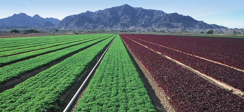
Arizona is the second largest producer of lettuce and were approximately 160,000 milk cows in Maricopa
spinach in the US, with 72,100 acres of land in production and Pinal Counties, while in 1990 there were fewer
for all types of lettuce. Fresh vegetables (including lettuce) than 100,000 milk cows in the entire state. The need to
and melons, mostly grown in Yuma County, contributed produce feed for dairy cows changed how and what crops
$2.5 billion to the state’s economy in 2015. Arizona melon are grown, with alfalfa replacing cotton in some areas.
growers produce about 25 percent of U.S. cantaloupe and
honeydew melons. Southern Arizona, with a climate
favorable for growing cotton, had approximately 175,000
History of Irrigated
acres in production in 2017. Grain, including barley and
wheat, are also grown throughout central and southern
Agriculture in Arizona
Arizona. In terms of quantity produced, the state ranked Indigenous Agriculture
3rd nationally for production of durum wheat in 2014.
Figure 1 shows the common crops grown in Arizona and Archeological evidence suggests that irrigated
the acres in production for each type of crop for 2012, agriculture first arrived along the Santa Cruz River in
the year of the latest published Census of Agriculture. southern Arizona around 1200 BCE. During this time,
irrigation canals were constructed along the river near
2 Arroyo 2018
the current Interstate-10 corridor just west of Tucson.        to droughts and long periods of low flow as well as floods
These early farmers irrigated corn, tobacco, and squash.       that overwhelm and destroy irrigation infrastructure.
      Between 300 BCE and 1450 AD, native people               Despite these challenges, Jack Swilling built the first
constructed a network of canals near the Salt and Gila         community irrigation ditch in the Phoenix area using
Rivers in South Central Arizona, where they developed a        the remains of original Hohokam canals. Other private
distinct culture known as “Hohokam.” Evidence of these         irrigation projects in the Phoenix area soon followed.
canals exists today throughout the Salt River Valley,          By the 1880s, crops such as fruit trees, alfalfa, and grain
including the site of the Pueblo Grande Village on the east    made farming profitable in the Salt River Valley. The
side of Phoenix. These canals are also found throughout        development of irrigation systems allowed for 113,000
the Gila River Valley, including large canals near the Casa    acres of Maricopa County to be brought into production
Grande Ruins west of Florence. The disappearance of this       by 1900. By this time, the Salt River Valley needed a more
civilization may have been due to changes and variability      reliable water supply; however, it lacked the financial
of the local climate.                                          resources to build a large reservoir.
      Following the demise of the Hohokam culture,                   The Reclamation Act of 1902 permitted the federal
the Akimel O’odham (Pima), as likely descendants of            government to fund the construction of dams and other
the complex Hohokam culture, became established in             irrigation projects in semi-arid western states, such as
southern and central Arizona. The Pima later allied with       Arizona, through interest-free loans. The Salt River Valley
the Xalychidom Piipaash (Maricopa), and these tribes           Water Users’ Association, formed in 1902, was made up
continued using irrigated agriculture. By the mid-19th         of Salt River Valley farmers and landowners who were
century, when American and Europeans made the trip             willing to pledge their lands as collateral for a reclamation
across the deserts of the Southwest to reach the California    project. The Association applied to the Reclamation
gold fields, the Akimel O’odham were diverting water           Service for construction of Roosevelt Dam on the Salt
from the river to agricultural fields in the valley of the     River, and Roosevelt Dam became one of the first storage
Middle Gila, creating a virtual breadbasket in Arizona. By     projects completed under the federal reclamation
1860, they were cultivating nearly 15,000 acres of land        program. Construction of the dam was completed in
and supplied large quantities of wheat, corn and other         February of 1911, despite delays in construction caused
foodstuffs to the U.S. military and traded farm products,      by flooding during the several winter seasons. Operation
such as corn, beans and squashes, to travelers and settlers.   and maintenance of Roosevelt Dam and other project
      By the late 1800s, American settlers had diverted        facilities, which later became part of what is now the Salt
much of the water of the Gila River that supported native      River Project (SRP), was transferred by the Reclamation
agriculture, causing the Pima and Maricopa tribes to lose      Service (now the U.S. Bureau of Reclamation) to the Salt
their livelihood, ushering in the “forty years of famine”      River Valley Water Users’ Association in 1917. SRP and
and hardship for the tribes. Throughout the 20th Century,      the Bureau of Reclamation later constructed three more
they struggled to gain recognition of their water rights       dams on the Salt River, while the two Verde Rivers dams
and a water supply based on those rights. Despite tribal       were constructed by SRP and other entities (Figure 2).
water rights being considered in various court cases in the          Although in 1903 landowners paid ten cents per
first half of the 20th century, and water rights settlements   acre in expectation of becoming shareholders in the
with the Salt River-Pima Maricopa Indian Community,            project, subscription of lands did not begin until 1917.
Fort McDowell Yavapai Nation, and Ak-Chin Indian
Community, the Pima and Maricopa from the Gila River
Indian Community continued to struggle in securing
their water. In 2004, the Arizona Water Settlements Act,
settled the water claims of multiple parties, including the
Gila River Indian Community (GRIC). The GRIC intends
to use its right to 653,500 acre-feet of water to rebuild
tribal agriculture, among other uses, with a goal of more
than 77,000 acres of irrigated farmland. Most of Arizona’s
22 tribes engage in some level of irrigated agriculture,
including the Ak Chin, the Tohono O’odham, Ft. Mohave,
Navajo, Cocopah, and the Colorado River Indian Tribes.

Agricultural Development 1850 - 1968
     Settlers from the eastern United States began to
arrive in Arizona during the 1850s, and in 1863, the state
became a U.S. territory separate from New Mexico. For
these settlers, irrigation for agriculture was challenging      Figure 2: Salt and Verde River watersheds, the Salt River
to implement because rivers in the Southwest are prone          Project (SRP) water storage dams, and water service area.
                                                                Image: Salt River Project
                                                                                                       Arroyo 2018          3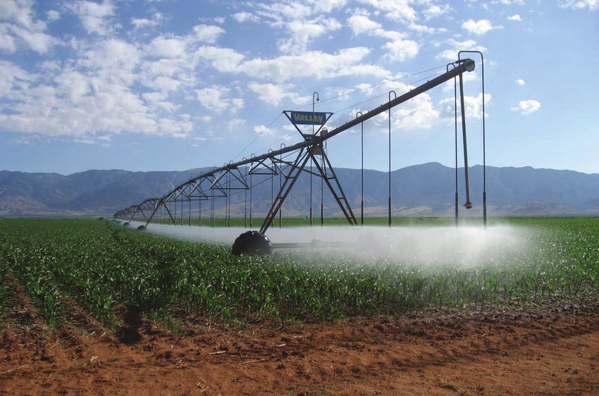
Subscriptions ultimately reached roughly 248,000 acres.       over pumping throughout the groundwater dependent
Historically, SRP provided over a million acre feet of        agricultural regions of the state. During that time, the
annual water supply to a predominantly agricultural           state of Arizona was using 2.3 million acre-feet per year
economy. Today, because of water conservation efforts         of groundwater in excess of natural recharge. In a 1963
and increased water use efficiencies, SRP provides central    report Congressman Morris K. Udall stated ominously,
Arizona with approximately 800,000 acre-feet of water         “Eventual water bankruptcy is the guaranteed result
per year, primarily for municipal and industrial use in       of this kind of policy.” In this context, securing federal
the Phoenix Metro Area. Urbanization of the Project area      funding for construction of a canal to divert water from
has reduced the farmland remaining in cultivation to          the Colorado River to the farms and cities of Central
just 20,000 acres.                                            Arizona was considered imperative. Congress passed and
      The dams and major irrigation projects on the Lower     President Lyndon B. Johnson signed that act authorizing
Colorado River were also constructed by the U.S. Bureau       the Central Arizona Project (CAP) in 1968. Groundwater
of Reclamation. Hoover Dam, which forms Lake Mead             overdraft in the 1960s and 1970s was so severe, however,
(the largest reservoir in the United States), was completed   that then Interior Secretary Cecil Andrus threatened to
in 1936, during the Great Depression. Water stored in         eliminate funding for CAP if Arizona did not implement
Lake Mead is used by Arizona, Nevada, California, and         policy to manage its shrinking groundwater supplies.
Mexico. Further downstream, on the Colorado River are         Under this threat, the Arizona legislature passed the
Davis Dam (Lake Mohave), Parker Dam (Lake Havasu), and        1980 Groundwater Management Act (GMA).
Imperial Dam. These structures were completed in 1950,             Since the passage of the GMA and the arrival of
1938, and 1938, respectively. Irrigation canal systems        CAP, overdraft has decreased within areas of the state
constructed by Reclamation in Arizona include the Yuma        designated for active management, including Phoenix,
Project, Yuma Auxiliary Project, and Gila Project.            Pinal, Prescott, Santa Cruz, and Tucson. Within these
      The Yuma Project was built between 1904 and             Active Management Areas (AMAs), groundwater
1912. Water for the Yuma Project is diverted at Imperial      withdrawals for irrigated agriculture are limited.
Dam. Its Valley Division now reaches 53,415 acres of          In the Phoenix, Pinal and Tucson AMAs, which are
land in Arizona. The Yuma Auxiliary Project (now Unit         within the CAP service area, irrigated agriculture has
B Irrigation District) first delivered water to farmers in    transitioned to more use of renewable CAP water.
1905. This project diverts water, also from Imperial Dam,     Issues relating to potential Colorado River shortage,
to 3,400 acres east of Yuma Project land. The Gila Project    however, are threatening to push some irrigators back
was completed in 1957, as a response to excessive             onto groundwater (see section on the Colorado River,
groundwater pumping and increased soil salinity in the        on page 8). In farming areas that lack both regulation
Gila Basin. The Gila Project includes several irrigation      of groundwater extraction and access to Colorado River
districts that collectively serve 98,000 acres                water, the problem of overdraft is a continuing concern.

Groundwater Use, the Groundwater
Management Act, and Central Arizona
                                                              A Profile of Irrigated
Project                                                       Agriculture in Arizona
     As the state of Arizona grew, agriculture and urban           This section relies heavily on the Arizona Water
development began to rely on groundwater. According           Atlas compiled by ADWR, which generally covers the
to the Arizona Department of Water Resources, in 2014         period from 2001 to 2005. Data from the U.S. Department
groundwater accounted for 40 percent of the state’s           of Agriculture’s 2017 Agricultural Survey suggests that
annual water use. Large portions of central and southern      in most areas the picture of irrigated agriculture has
Arizona are favorable for groundwater pumping, as deep        not changed substantially, but exceptions will be noted.
aquifers in these areas hold substantial amounts of water,    Trends in agricultural water use for groundwater basins
although in some areas pumping in excess of recharge has      are shown in Figure 3.
resulted in significant declines in groundwater levels.            Water use for irrigated agriculture varies throughout
Pumping more water from aquifers than is naturally            the state. The Water Atlas defines seven regions or
recharged is called groundwater overdraft or mining.          “planning areas” (Figure 4), which are used in this
     Arizona’s groundwater overdraft problem was              section. (The seven Water Atlas planning areas should
most severe from the late 1940s through the passage           not be confused with the 22 “planning areas” delineated
of the 1980 Groundwater Management Act (GMA). In              by ADWR in 2014 to identify and develop strategies to
1937, the invention of the centrifugal turbine pump           address water use and supply imbalances throughout
permitted extraction of groundwater from greater              Arizona.) Figure 5, which shows all irrigated areas
depths. This contributed to rapid growth of irrigated         throughout Arizona, indicates that most agriculture is
agriculture throughout Arizona between 1940 and 1953.         concentrated in South Central Arizona south of Phoenix
This rapid growth in irrigated agriculture resulted in        and in the southwest corner of the state near Yuma.

4    Arroyo 2018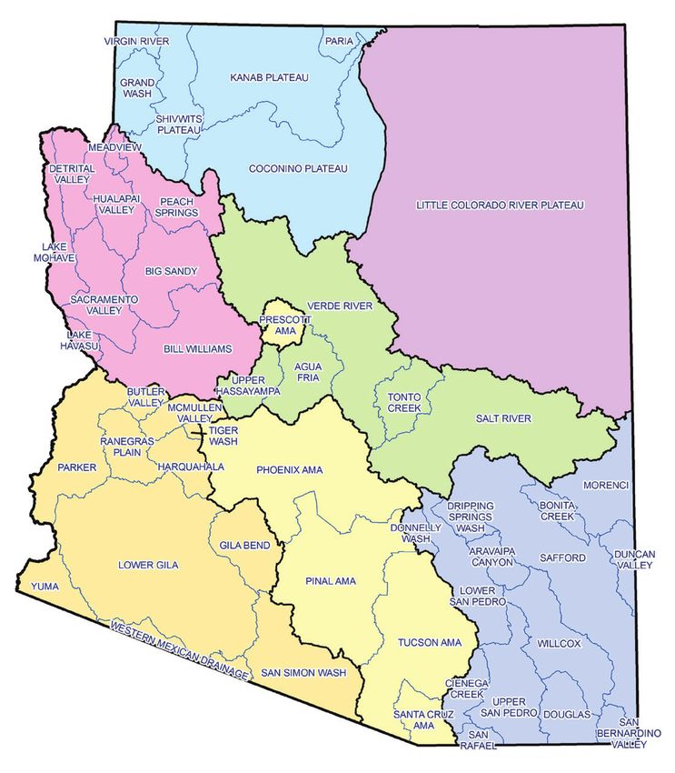
Southwest Arizona
      A substantial concentration of irrigated
agriculture in Arizona is in the southwest corner of
the state near the city of Yuma. Designated the Lower
Colorado River Planning Area in the Arizona Water
Atlas, this region extends from the southwestern
corner of Arizona through the Lower Gila Basin and
includes part of the Tohono O’odham Nation on
the east. The Atlas reported more than 2.8 million
acre-feet of water use per year for non-Indian
irrigated agriculture between 2001 and 2005. This
represents 98 percent of the Planning Area water
use and 36 percent of Arizona’s total annual water
use of 6.9 million acre-feet for the period. Most of
the water used in this area came from Colorado
River diversions (63 percent) and groundwater (33
percent). Much smaller amounts came from the
Colorado River via the Central Arizona Project and
from Gila River surface flow.
      The Lower Colorado River Planning Area
comprises 11 basins, several with significant
agricultural water use. The Yuma Basin used
994,200 acre-feet of water per year, 77 percent
                                                            Decreasing
from Colorado River diversions and the rest from
groundwater. The Yuma Basin relies on two U.S.              No Trend

Bureau of Reclamation irrigation projects: the              Increasing
Yuma Project and the Gila Project. Farms within             No Data
the Yuma Project, rotate crops between seasons,
irrigating wheat, cotton, hay, melons, and seed Figure 3. Trends in agricultural water use in groundwater basins 2006-
crops in the summer and vegetables during the fall 2016 and Active Management Areas 2006-2009. Data sources: U.S.
and winter. Crops grown within the Gila Project Geological Survey and Arizona Department of Water Resources
districts include alfalfa, cotton, melons, citrus,          include melons, cotton, sorghum, vegetables, oats, alfalfa
vegetables, Bermuda grass, and grain.                       and other hay, corn, guayule, pistachios, date palms, and
      The Lower Gila Basin, east of Yuma, used 629,000 oats. In the Gila Bend Basin, groundwater wells supplied
acre-feet per year from 2001-2005 for agriculture, of about 289,000 acre-feet of water per year to grow mostly
which, 60 percent was from the Colorado River. Most of cotton, alfalfa, and grain.
the irrigation in this area is located along the Gila River         The Harquahala Basin is designated as an Irrigation
and water is supplied through the Wellton-Mohawk Non-Expansion Area (INA), which means that no new
Irrigation and Drainage District. Primary crops grown lands may be irrigated. Irrigation has varied substantially
include vegetables, alfalfa, melons, and wheat.             in the Harquahala INA from only about 37,000 acre-feet
      North along the Colorado River, Parker Basin in 1991 to about 150,000 acre-feet in 2016, with CAP
agriculture used an average of 630,600 acre-feet per year water supplying about 25 percent of the total. Primary
in 2001-2005, almost exclusively Colorado River water. crops include alfalfa and hay, cotton, wheat, melons,
Most of this water was used by the Colorado River Indian corn, sorghum, grasses, oats, and trees. Elsewhere in the
Tribes (CRIT) for alfalfa, cotton, and durum wheat. The Lower Colorado Planning Area, irrigated agriculture is
Cibola Valley Irrigation and Drainage District owns limited and produces primarily alfalfa.
the canal system that serves much of the non-Indian
irrigated agriculture in the basin. Crops include alfalfa, Central Arizona
Bermuda grass, cotton, vegetables, wheat, and barley.
      Away from the Colorado River, irrigators rely                 South Central Arizona, designated the “Active
primarily on groundwater. In the Gila Bend Basin, growers Management Area Planning Area” in the Arizona Water
use groundwater to grow alfalfa and other hay, sorghum, Atlas, has the second-largest agricultural water demand
and wheat. In the McMullen Valley Basin, water demand in Arizona. Non-Indian agriculture used an average
for irrigated agriculture fluctuated around 90,000 acre- of 1.8 million acre-feet of water per year between
feet during 2001-2005 and has trended slightly lower 2001 and 2005. Most irrigated agriculture in the AMA
since. Crops in this basin, which rely on groundwater, planning area is in the Phoenix and Pinal AMAs. Major

                                                                                                   Arroyo 2018       5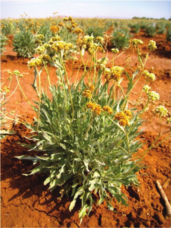
Drainage District is able to use surface water from the
                                                               Gila River.
                                                                    Further south, Tucson AMA agriculture used
                                                               approximately 96,600 acre-feet of CAP and groundwater,
                                                               or only about 5 percent of Arizona’s total agricultural use.
                                                               The Cortaro-Marana Irrigation District, near the town of
                                                               Marana, supplies water to grow cotton and grain in the
                                                               Avra Valley through its system of wells and canals. The
                                                               Avra Valley Irrigation District, BKW Farms, and other
                                                               irrigators also operate in this area. Pecan production by
                                                               Farmers Investment Company near Green Valley uses
                                                               groundwater as there is no CAP infrastructure in the
                                                               Green Valley area at this time.
                                                                    Native American communities used an additional
                                                               377,600 acre-feet of water per year in the AMA Planning
                                                               Region. The Ak-Chin Indian Community, Fort McDowell
                                                               Yavapai Nation, Gila River Indian Community, Salt
                                                               River Pima-Maricopa Indian Community, and Tohono
                                                               O’odham Nation all use water for irrigated agriculture.

                                                               Other Regions of Arizona
                                                                     There is little irrigated agriculture on the sparsely
Figure 4. Arizona Water Atlas Planning Areas. Image: Arizona   populated and largely undeveloped Eastern Plateau
Department of Water Resources
                                                               and Western Plateau of Arizona. Major crops include
crops are alfalfa and hay, cotton, wheat, barley, corn,        alfalfa and rye grass. On the Eastern Plateau there are
and vegetables, and citrus, although very little, if any,      some orchards and pasture. The Central Highlands have
citrus is grown in Pinal County. Further south, pecans         irrigated pasture.
and cotton are grown in the Tucson AMA. In the 2001-
2005 period the AMAs together used groundwater (46
percent), CAP water (38 percent), in-state river water (14
percent), and treated effluent (2 percent) for agriculture.
More recently, with the availability until 2017 of 400,000
acre-feet of Agricultural Settlement Pool water, the CAP
irrigation districts were using 60 percent surface water
(mostly CAP) and 40 percent groundwater.
     Within the Phoenix AMA, there are 33 irrigation
districts; however, 80 percent of the water in the
AMA is managed by seven districts including SRP.
Agricultural water use in SRP and in the Roosevelt Water
Conservation District declined between 1984 and 2002
due to urbanization in the Phoenix Metro Area, while
water use in other irrigation districts either remained
stable or increased.
     In the Pinal AMA, four irrigation districts manage
87 percent of the water, and their water use exceeds
800,000 acre-feet per year. Most districts supplement
CAP water with pumped groundwater. The Maricopa-
Stanfield Irrigation & Drainage District (MSIDD), one
of the two largest irrigation districts in the Pinal AMA,
operates the Santa Rosa Canal, which delivers CAP water
to MSIDD, the Ak-Chin Indian Community, and about
one-third of the Central Arizona Irrigation and Drainage
District (CAIDD). The MSIDD also produces groundwater
from 150 irrigation wells, 80 of which are connected
directly to its canal system. The San Carlos Irrigation and    Figure 5. Areas of irrigated agriculture in Arizona are shaded
                                                               in green. Image: U.S. Geological Survey

6    Arroyo 2018
Agricultural demand in the Upper Colorado              and surface water. Surface water is distributed through
Planning area, which comprises the southern half of          the Gila Valley Irrigation District. In the Willcox Basin,
Mohave County and parts of Maricopa, La Paz, and             167,000 acre-feet per year of groundwater were used to
Coconino Counties in western Arizona, has increased          irrigate primarily corn, alfalfa, orchards, and vegetables.
in recent years. Between 2001 and 2005, agricultural         The Douglas Basin, an INA, uses approximately 47,300
water demand was 99,550 acre-feet per year. Most of the      acre-feet of water per year for corn and alfalfa. Irrigated
water for irrigation is used by the Fort Mojave Indian       agriculture also occurs in the Duncan Valley and
Tribe in the Lake Mohave Basin. Other water users within     Upper and Lower San Pedro Basins of the Southeastern
the basin operate wells and distribution infrastructure      Planning Area. Groundwater overdraft has become a
to irrigate cotton, alfalfa, other hay, and wheat. Since     major challenge throughout the area, and it is leading to
publication of the Water Atlas, irrigated agriculture in     some environmental problems, such as subsidence and
the Hualapai and Sacramento Basins east of the river         the formation of land fissures.
has grown on groundwater. More recent data for these              The Cochise Planning Area, one of the 22 planning
basins show that agricultural water use increased from       areas ADWR defined in 2014, lies within the Water
zero in 2001-2005 to more than 32,000 acre-feet in 2016,     Atlas’s Southeastern Arizona Planning Area (Figure 6).
and irrigated agriculture continues to grow. In 2016, in     Throughout the Cochise Planning Area, well owners
order to forestall explosive growth in water demand for      reported 18 wells to have gone dry between 2008 and
new irrigated agriculture, Mohave County asked ADWR          2014, however this number probably far underestimates
to designate the Sacramento Valley groundwater basin         the actual number of wells that went dry. In 2015,
and Hualapai Valley groundwater basin as separate            residents of the San Simon Valley sub-basin within the
INAs. The ADWR found that the evidence it possessed          Safford groundwater basin petitioned ADWR to have the
on groundwater conditions in the basins did not support      sub-basin designated as an INA; however, ADWR declined
the initiation of INA designation procedures.                to designate an INA after its groundwater modeling study
      Within the Southeastern Arizona Planning Area,         and other evidence showed sufficient groundwater for
farmers in the Safford Basin irrigated cotton, grain, and    irrigation of the cultivated lands in the area at the rates
alfalfa with 181,700 acre-feet per year of groundwater       of withdrawal current at the time of the study.

                                                             Regulation of
                                                             Groundwater Use for
                                                             Agricultural Irrigation
                                                                   The GMA effectively divided Arizona into three
                                                             categories. Areas within the state that are subject to the
                                                             most regulations are AMAs, as these were the areas that
                                                             experienced the worst groundwater overdraft during
                                                             the mid-20th century. Within an AMA, irrigators have
                                                             quantified grandfathered irrigation rights. Wells with a
                                                             pumping capacity of 35 gallons per minute or less are
                                                             exempt from most AMA regulations, but cannot be used
                                                             for large-scale irrigation. Grandfathered irrigation rights
                                                             are tied to specific parcels of land that were irrigated
                                                             between 1975 and 1980. The quantity of the right is
                                                             based on the water use and crop types grown on that
                                                             land at that time. No new land in an AMA may be brought
                                                             into agricultural production. An owner of land with an
                                                             irrigation right may extinguish that right in exchange
                                                             for transferable water credits, but once extinguished
                                                             the right to irrigate may not be reestablished. Holders
                                                             of irrigation rights are regulated under either the base
                                                             conservation program, which is associated with an
                                                             annual allotment of water but allows some flexibility
                                                             through transfer of credits between farms; or under
                                                             the Best Management Practices conservation program,
Figure 6. Cochise Planning Area within the Arizona Water     requiring implementation of a number of BMPs designed
Atlas’s Southeastern Arizona Planning Area. Image: Arizona   to improve efficiency of water use. All users of wells with
Department of Water Resources
                                                                                                    Arroyo 2018       7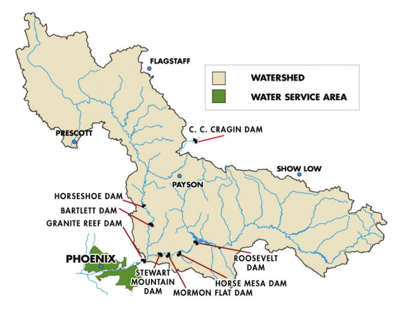
capacities of 35 gallons per minute or more in AMAs
must pay groundwater withdrawal fees, and users of               Timothy Lahmers, a
these wells must also report withdrawals, so that water          Hydrometeorology PhD
use in the AMA can be tracked.                                   candidate at the University of
                                                                 Arizona, prepared the initial
     Less actively managed than AMAs, INAs are
                                                                 draft of this Arroyo as the 2017
areas where no new lands may be brought into
                                                                 Summer Writing Intern at
agricultural production. Irrigation groundwater rights
                                                                 the WRRC. His areas of current
are not quantified and no withdrawal fee is charged              research include atmospheric
for groundwater pumping. Elsewhere in the state,                 modeling, distributed
groundwater withdrawal is not regulated by the GMA,              hydrologic modeling, and
although wells must still be registered with ADWR.               hydrometeorology in semi-arid environments. He hopes
     The GMA allows for the creation of new AMAs and             in the future to apply this research to understanding
INAs when needed for a number of reasons, including              the effects of climate change on extreme weather and
protection of the groundwater supply. In the Willcox             water resources in the western US.
Basin, local residents explored the option of forming
either an AMA or INA but rejected both options. The
prohibition against bringing new lands under cultivation     recent years and started to pump groundwater. Residents
was a major sticking point. Stakeholders favored             in Kingman are concerned that the increased pumping
establishing new vineyards, which thrive in soils where      may threaten their wells and property and that the
other crops would fail and are a high value and relatively   community could eventually run out of water. Because
low water use crop compared to other agricultural            this level of groundwater pumping is a relatively new
commodities. The local stakeholders realized a new           phenomenon in Mohave County, there is an opportunity
“third way” was needed, and they developed a concept         for local residents, farmers, and the state government to
that incorporated some of the AMA conservation               work together to find a sustainable long-term solution
requirements but allowed for expansion of irrigated land     before substantial groundwater overdraft occurs.
for new low water use crops. Although this concept was             Lowering of the groundwater table can also have
not adopted in the Willcox Basin, it illustrates the kind    negative environmental consequences. The geology
of new ideas that may be needed in areas dealing with        across most of southern and western Arizona is
overdraft.                                                   associated with areas of high mountains and deep
                                                             valleys where sediments have accumulated in some
Issues with Unregulated Groundwater                          areas to depths of over 5000 feet. These sediments are
Use                                                          filled with groundwater that can be easily pumped;
                                                             however, depending on geologic conditions, overdraft
     Despite Arizona’s vast stores of groundwater,           may cause pore spaces between sediment particles to
overdraft of the state’s aquifers is not sustainable in      collapse as water is removed. This compaction of the
the long-term. Groundwater overdraft is a challenge          sediments causes the land to sink, a process called
for irrigated agriculture in Arizona, as drilling deeper     subsidence, which can permanently reduce the storage
wells and pumping from greater depths can become             capacity of the aquifer. One of the possible consequences
prohibitively expensive. The problem of groundwater          of subsidence is the formation of fissures or cracks in
overdraft has become severe enough in the Willcox area       the ground. Fissures generally occur where an aquifer
that irrigation wells are often drilled to over 1,200 feet   boundary meets bedrock, so they seldom open within
deep. In 2017, the cost to drill a well to 1,200 feet was    irrigated fields; however, they can damage canals and
approximately $420,000. In addition, an irrigator’s most     well casings. In addition, subsidence can cause regional
expensive input is energy, and the energy needed to          and local flooding and alter the slope of land used to
pump water from ever greater depths can be significant.      grow crops, changing the flow direction of irrigation
In areas like Willcox, where severe groundwater              water, and thus reducing irrigation efficiency. Farmers
overdraft is occurring, the costs to extract water may       on subsidence prone lands may therefore need to relevel
eventually exceed the farm revenue, making irrigation        fields to keep them in production.
too expensive for farmers.
     In the Willcox Basin, existing agricultural
groundwater uses and new farm pumping have caused
                                                             Reliance on Colorado
problems for homeowners with relatively shallow
wells. Drilling costs to deepen wells can be too high for
                                                             River Water
some residents to afford, meaning that they have to live          To reduce the effects of overdraft, many farms in
without a reliable supply of water. Groundwater overdraft    Central Arizona have turned to CAP for water. Arizona is
has also recently caused concern in Mohave County,           allocated 2.8 million acre-feet per year of consumptive
where new farming businesses have purchased land in          use from the Colorado River, and approximately 1.6

8    Arroyo 2018
million acre-feet per year are transported through the               Per the 2004 settlement, water sold to farms and
CAP system. The rest of the state’s allotment is diverted      irrigation districts from the Ag Pool is priced based on the
from the river, mostly for irrigated agriculture along the     energy cost of CAP water delivery. Even this reduced price
mainstem and adjacent areas.                                   began to look high to growers when the Central Arizona
     The priority of water rights for different Colorado       Water Conservation District (CAWCD), the entity created
River water users in Arizona varies based on when the
                                                                           1,600,000
water was first used or the rights were acquired. First
priority water rights predate the Boulder Canyon Project
Act of 1928. Second and third priority water users                                            Other Excess
established their rights by secretarial reservation or                     1,400,000
contract before September 30, 1968. Second and third
priority rights are coequal. Fourth priority water rights
were established by contract after September 30, 1968.                     1,200,000              Ag Pool
Most CAP water is fourth priority, and fourth priority
water will be the first to be cut in the event of a shortage
on the river.                                                              1,000,000
                                                                                               NIA Priority
CAP Water Use by Arizona Irrigators

                                                               Acre Feet
                                                                             800,000
      The CAP transports water from the Colorado River
at Lake Havasu in western Arizona to water users in
Maricopa, Pima, and Pinal Counties. The 336-mile long                        600,000
canal and associated structures were authorized by
Congress in 1968. Originally envisioned as the salvation                               Indian               M&I
of irrigated agriculture in Central Arizona, CAP has                         400,000
                                                                                       Priority            Priority
become a major water source for municipalities, water
companies, industrial users, and Native American tribes,
as well as farms and irrigation districts in Maricopa,                       200,000
Pima, and Pinal counties.
      The CAP was completed in 1993. It became clear at
that time that the original structure for payments by CAP                                         Priority 3
                                                                                   0
customers had problems, including an unsupportable
burden on agricultural subcontractors. Efforts to solve        Figure 7. Current use of Central Arizona Project water
                                                               priority pools, prior to system conservation activities top
these problems included negotiations and litigation.
                                                               to bottom shows lowest to highest priority. Image: Central
Issues were largely resolved in 2004 by the Arizona
                                                               Arizona Project
Water Settlement Agreement, in which non-Indian CAP
agricultural subcontractors relinquished their long-           by the state to repay the federal government reimbursable
term CAP entitlements in exchange for a commitment             costs for CAP construction and contract for the delivery
by CAP’s governing board to deliver a declining pool of        of CAP water, began projecting increased costs for power.
Excess Water through 2030 at energy-only rates. Known          In 2009, the CAWCD began an agricultural incentive
as the Agricultural Settlement Pool or “Ag Pool”, this pool    program to further reduce CAP water costs for agriculture.
supplies a large portion of the irrigated agriculture in the   In exchange for incentive pricing, growers were required
CAP three-county service area.                                 to meet specific CAWCD goals for water use, storage, and
      Since 1983, CAP water has been divided into the          recovery.
following pools (Figure 7): some Priority 3 water, Indian            The CAP had good reason to provide incentives for
Priority and Municipal and Industrial (M&I) Priority Pools,    the agricultural use of project water. By the Reclamation
Non-Indian Agricultural (NIA) Pool, and excess water. The      Act of 1902, agricultural districts are not required to pay
Agricultural Settlement Pool (Ag Pool) was added in 2004.      interest on the debt incurred to the federal government for
Assigning a low priority to the Ag Pool means that Central     construction of reclamation projects. Because irrigated
Arizona agriculture will be the first to feel the effects of   agriculture uses Ag Pool water, CAP’s interest payment
a shortage on the Colorado River. The purchase of water        obligation was reduced.
in the Ag Pool is subject to availability and decreases over         In addition to buying water from the Agricultural
time. It decreased from 400,000 to 300,000 acre-feet per       Settlement Pool, another way for agricultural water users
year in 2017. In 2024, the pool will shrink to 225,000 acre-   to take CAP water is by becoming a permitted Groundwater
feet per year, and it is scheduled to be eliminated entirely   Savings Facility (GSF). A GSF is typically an individual
after 2030.                                                    farm or irrigation district in an AMA. In lieu of pumping
                                                               groundwater, the GSF uses CAP water supplied by a CAP

                                                                                                        Arroyo 2018          9
subcontractor or entity created to bank (Arizona Water for Lake Mead is at or below an elevation of 1075 ft. on
Banking Authority) or replenish water (Central Arizona December 31st in any year, a Tier 1 shortage is declared
Groundwater Replenishment District). This water is also and Arizona’s allocation is reduced by 320,000 acre-feet.
known as “in lieu” water. In order for a GSF to be permitted, This reduction increases to 400,000 and 480,000 acre-
the farm or irrigation district must prove that without “in feet per year if the Lake Mead elevation drops to 1050
lieu” water, groundwater pumping is the only feasible way feet and 1025 feet, respectively. In the event that a Tier
to obtain water. A GSF is permitted to substitute in lieu 1 shortage is declared, CAP’s excess water pool will be
water on a gallon-for-gallon basis for groundwater that eliminated and a portion of the Ag Pool water will be
otherwise would have been pumped. reduced. As Lake Mead falls, more CAP water users will
be affected, including municipal and industrial (M&I)
Potential Colorado River Shortages and Indian priority water users. At Lake Mead falls below
and Impacts on Agriculture 1075 feet, the secretary of the interior will consult with
the Basin States on measures to be taken. Only if Lake
The eventual elimination of the Ag Pool is only one Mead drops below 1025 feet, are Arizona’s senior water
challenge that farmers who rely on CAP water will face rights holders, such as irrigators in the Yuma area,
in the coming years. Water use in the Lower Colorado potentially affected.
River Basin exceeds normal inflows to Lake Mead each Over the past two decades a severe drought has
year. When combined, a normal release of 8.23 million exacerbated the water situation on the Colorado River.
acre-feet from Lake Powell and approximately 0.7 During this time, the Lower Basin has experienced its
million acre-feet of inflow from tributaries yields a total lowest 16-year period of inflow in over 100 years of record
average operational inflow into Lake Mead of 9.0 million keeping The volumes of water left in Lake Mead under the
acre-feet. Given the basic apportionments to the Lower various incentive programs have slowed but not stopped
Basin states, the allotment to Mexico, and evaporation Lake Mead’s decline. As a result, the Lower Basin states
losses, Lake Mead annual outflow is about 1.2 million and the Bureau of Reclamation began discussing new
acre-feet more than the annual inflow. The result is an incentive programs and a new framework for shortage
imbalance that causes Lake Mead to drop by 12 feet or sharing.
more every year. This “structural deficit” is leading to In this context, the Lower Basin Pilot Drought
consistent declines in the water storage in Lake Mead Response Actions Memorandum of Understanding
such that the status quo is not sustainable (Figure 8). This (MOU) was signed on December 10, 2014. This MOU
problem is likely to get worse given warming climate committed Arizona to use its best efforts to create
trends. Streamflow on the Colorado River is projected 345,000 acre-feet of water in Lake Mead between 2014
by multiple studies to decrease by at least 10 percent in and 2017. To meet this goal, several programs were
the next century. In addition,
severe drought conditions are
highly likely to occur in the
coming decades.
In 2007, an agreement
among the Lower Basin states
and the Bureau of Reclamation
was codified in the Colorado
River Interim Guidelines for
Lower Basin Shortages and the
Coordinated Operations for
Lake Powell and Lake Mead.
Commonly known as the
2007 Interim Guidelines, it
established a shortage sharing
framework for the Lower
Basin, incentives storing water
in Lake Mead, and coordinated
operations of Lake Powell
and Lake Mead. The shortage
framework contains three
shortage tiers based on Lake
Mead elevations. If the Bureau
of Reclamation’s August
24-Month Study projection Figure 8. Lake Mead elevation from 2000 through May 2017 showing consistent reduction
in storage interrupted by wet years. (EOM=End of Month) Image: Central Arizona Project
10 Arroyo 2018developed within Arizona, including two agricultural
forbearance programs that allowed Central Arizona
agricultural districts to leave part of their CAP allocations
Irrigation Efficiency v. Water
in Lake Mead. With the voluntary participation of SRP Conservation
and 11 irrigation districts and farms, these two programs
together resulted in an estimated 216,000 acre-feet of The irrigation efficiency of an agricultural operation may
water left in Lake Mead from 2014 through the end of be defined as the ratio of water beneficially used to the
2017. Other system conservation activities left over total amount of water applied. As more of the applied
water goes to beneficial uses rather than non-beneficial
475,000 acre-feet in the reservoir over the same period,
uses, efficiency increases. Non-beneficial uses of water
including almost 170,000 acre-feet from the Tohono
include evaporation, deep percolation, and tail water
O’odham, CRIT, and GRIC.
runoff.
The Lower Basin Drought Contingency Plan (LBDCP)
is a policy proposal that includes cooperation among An example offered by Noel Gollehon (USDA) at the
Arizona, Nevada, California, Mexico, and the U.S. Bureau WRRC 2017 conference demonstrates that efficiency is
of Reclamation to prevent the elevation in Lake Mead not necessarily the same as conservation. Conservation
from dropping to elevations that might trigger draconian means a reduction in the amount of water consumed.
reductions. The details of the LBDCP are still being In Gollehon’s example, eight units of water are legally
allocated to a farmer and diverted from a river. Of these
debated among Lower Colorado River Basin states. Under
the LBDCP, cuts would begin sooner, and later cuts would River Flow (110) River Flow (110)
be deeper. The LBDCP effectively would reduce CAP
deliveries by 192,000 acre-feet per year when the Lake
Beneficial Use (4) Beneficial Use (4.8)
Mead elevation drops below 1090 feet eliminating the Diversion (8) Diversion (8)
excess water pool. Below 1075 feet the total reduction
in CAP deliveries is schedule to be 512,000 acre-feet
per year. These reductions would essentially eliminate
the Ag Pool at elevation 1075. If shortages are averted, 102 102
agricultural water users will continue to have access to
Agricultural Settlement Pool water, at least until 2030. System
Improvement
Agricultural Water Return Flow (4) Return Flow (3.2)
Conservation 106 Efficiency = 50% 105.2 Efficiency = 60%
Improvements to Irrigation Systems eight units, four are beneficially used and the other four
Farmers across the Southwest have been able to are returned to the river as tail water. This system would
reduce water use, while increasing yields, by making have an irrigation efficiency of 50 percent. Suppose
improvements to irrigation systems. In the Yuma that the farmer is able to increase irrigation efficiency
area for example, crop yields have increased while to 60 percent by improving irrigation technology. With
water use for irrigated agriculture has decreased by 15 this change 4.8 units of water are used beneficially
percent since 1990, due to reduction in irrigable acres, and the farmer returns only 3.2 units of water to the
river. The increased efficiency may benefit the farmer in
expanded use of multi-crop production systems, and
terms of increased yields, but less water is available for
improvements in crop and irrigation management and
downstream users.
infrastructure. Similar water-savings achieved across
Arizona agriculture can be attributed to these same
factors. In Central Arizona, where GMA conservation Surface irrigation is advantageous because it requires
and management rules apply, irrigation districts have minimal equipment and energy; however, it is typically
reached a remarkable efficiency of 85 percent. less efficient than other methods of irrigation. Vegetable
Taking improvements in irrigation infrastructure growers throughout the Yuma area, however, have
first, water savings have resulted from improvements refined the method to achieve an average efficiency of
to surface irrigation systems combined with the more 80-85 percent.
recent introductions of sprinkler and drip irrigation Improvements to surface irrigation systems include
systems where feasible and affordable. Surface irrigation laser-leveling fields, shaping furrows, lining ditches,
is the most common type of irrigation used in the and using high-flow irrigation gates. Fields are kept level
Southwest. Surface irrigation may either use furrows to so that water spreads evenly and does not pond in low
apply water to crops planted on rows, or flood irrigation places. Shorter furrows or borders also help water spread
to apply water to flat areas surrounded by borders. evenly. Fields are typically leveled at least once per year.
Arroyo 2018 11of a crop. This added efficiency means that less water has
to be applied to the crop. Drip irrigation, once installed,
may require less labor than other systems, although they
require more intensive management than conventional
systems. Drip irrigation is used throughout Arizona,
including Mohave County, Central Arizona, and the Yuma
area. Drip irrigation is also used to grow fruit and nut
trees in Cochise County and within the Fort McDowell
Indian Community.
While drip irrigation is one of the most efficient
ways to irrigate crops in the southwestern United
States, it has some notable drawbacks. Drip irrigation
systems have a high installation cost up to $2500 per
acre), making it impractical for farmers who lease
land. Increased soil salinity can be a problem with drip
irrigation and the salts must be flushed from the soil
Figure 9. Center pivot irrigation system at work in Arizona. to below the root zone by applying additional water. A
Image: U.S. Geological Survey practical downside of drip irrigation for farms that rotate
crops is that dripline systems cannot be changed or
Furrows are optimized to a trapezoidal shape, which moved once installed. If crop spacing varies for different
conveys water more evenly. To eliminate losses from crops that are rotated throughout the season, uniform
infiltration, irrigation ditches and canals are lined with water distribution will not always be possible with a drip
concrete, and high-flow irrigation gates flood fields more system. For germination of some vegetables, sprinkler
quickly, pushing water efficiently to the end of the field. irrigation must be used in addition to drip irrigation,
These practices are recommended by the ADWR Best which means increased costs. In addition, drip irrigation
Management Practices (BMP) program for use by farmers reduces or eliminates return flows used to calculate a
in Arizona’s AMAs and can also result in efficiencies farmer’s water diversion. It is for these reasons that drip
greater than 80 percent. By the early 1990s, most farms irrigation is used on less than 2 percent of agricultural
in Central Arizona had adopted these improved surface land in the Yuma area.
systems.
Sprinkler irrigation: solid-set, center pivot and Other Innovations to Conserve Water
linear move systems, can reduce water use compared
to flood irrigation (Figure 9). These systems consist Changes to agriculture practices have also been able
of an outlet-studded water pipe suspended over an to reduce water use throughout the state. In the Yuma
agricultural field. The entire system may be fixed (solid- area, farmers have been able to reduce their water use
set) or self-propelled to rotate around a central point by avoiding the need to irrigate during the warmest part
(center pivot) or to move along a line over a plot of land of the year, when evaporation is the highest. They do
(linear move). Water can be distributed evenly across a this by growing leafy green vegetables in the winter and
field to achieve efficiencies over 80 percent. Sprinkler warm season crops that mature in early summer, such
systems are effective in areas where soil infiltration rates as durum wheat, spring melons, Sudan grass, and early
are too high for flood irrigation or where, because of the season cotton. Alternating these two types of crops can
topography, ground leveling would damage the topsoil. actually use less than growing a single perennial crop
One of the ways sprinkler irrigation has been used that must be irrigated through late summer. As shown in
in Southwest Arizona is to germinate vegetable crops. Figure 10, water deliveries during late summer have been
With furrow irrigation, germination is achieved through greatly reduced since the 1970s, while water deliveries
the practice of keeping furrows filled with water for up to have increased much less during the late fall months,
10 days. Sprinkler irrigation reduces the amount of water when vegetable crops are germinated.
needed for germination from between 18 and 37 inches Water use has also been reduced through
to 8.5 inches. Sprinkler systems are also becoming more improvements to the timing of irrigation application.
common throughout Arizona. Monitoring the soil to irrigate just before maximum
Drip irrigation (also known as micro-irrigation) allowable depletion is reached helps farmers avoid using
consists of low pressure water lines that release water more water than is needed to maintain crop yields.
at or below the land surface. Drip irrigation can be Adding too much water reduces yields. Application of
customized for different crop types and applied in water to keep soil moisture above maximum allowable
fields with steeper topography than surface or sprinkler depletion is relatively simple with sprinkler systems, but
systems. Subsurface drip irrigation is highly efficient saving can also be achieved with surface systems.
because it releases water uniformly within the root zone
12 Arroyo 2018and squash – are associated with Native American
communities, where pre-European tribal farming and
growing techniques are used, such as open-pollination
or companion planting for high yields, low water input,
and overall soil and plant protection.
Potential New Crops
Efforts to find new crops to grow are constant. For
example, there are a few Arizona farmers trying to grow
agave, which may be marketable for tequila, fiber, and/or
biofuel. Cultivation of agave for the tequila industry has
been successful in Mexico.
Industrial hemp has also been considered as
a possible crop to grow in Arizona. With multiple
uses including textiles, industrial hemp requires less
water than cotton. A 2005 study by the Stockholm
Environment Institute showed that hemp required less
Figure 10. Mean water deliveries by month to irrigation water per pound of useful matter than cotton. The study
districts in Yuma contrasting 1970s and 2000s. Image:
also noted, however, that the technology for producing
Figure 3.5, A Case Study in Efficiency – Agriculture and
hemp cloth is limited and currently requires significant
Water Use in the Yuma, Arizona Area, Yuma County
manual labor.
Agriculture Water Coalition
Another limit to commercial hemp production is
The introduction of genetically modified crops the misperception that the hemp plant contains the
that are resistant to herbicides has made possible the mind-altering chemical THC, which resulted in its
adoption of no-till farming in Arizona. With no-till designation as a federal Schedule 1 narcotic. As in many
agriculture, farmers can leave biomass from harvested states, growing industrial hemp is illegal in Arizona.
crops on fields, which lowers soil temperature, reducing In 2017, legislation that passed the Arizona House and
soil evaporation and soil salinity. It can also prevent Senate would have legalized and regulated industrial
soil erosion. As of 2016, 94 percent of soybeans and hemp with a THC concentration of less than 0.3 percent.
89 percent of cotton and corn grown nationwide were The measure was vetoed by Governor Doug Ducey. but
herbicide tolerant. Shorter season varieties of cotton reintroduced in 2018. Regardless of Arizona’s actions,
have also been introduced that produce similar yields however, districts receiving water from federal projects
using less water. Despite concerns of some consumers, such as CAP are prohibited from using it to irrigate
GMO crops are widely accepted as safe among scientists industrial hemp.
and farmers. Another industrial crop with potential to help desert
The use of cover crops is another way that farmers farmers in the future is the guayule plant (Figure 11),
are able to reap the benefits of no-till farming without which can be used to produce commercial rubber. The
the use of herbicides. In Arizona, Duncan Family Farms amount of water needed to grow guayule is still an active
grows cover crops that are eventually shredded to add area of research. Early findings suggest that guayule
organic material back to soils and control weeds for water use may be comparable to sorghum and alfalfa.
their entirely organic farm. Note that USDA certified There have been some attempts to introduce guayule in
organic products do not contain GMO crops. Recent Arizona. In 2014, Bridgestone Americas opened a facility
growth of Arizona’s organic food production industry in Mesa to test and optimize guayule growing techniques.
has benefitted smaller farm operations like McClendon’s Bridgestone intends to use guayule for future production
Select, which specializes in providing locally grown of rubber tires. More research is needed to evaluate the
organic produce to farmer’s markets and locally owned viability and potential profitability of growing guayule in
restaurants throughout Phoenix, Tucson, Flagstaff and Arizona. Viability may depend on whether by-products
Sedona, AZ. not related to rubber production are marketable.
Other niche crops in Arizona are crops that were
grown by Native Americans prior to the arrival of Impediments to Agricultural Water
European settlers. One example of a traditional crop Conservation
is the Tepary bean, which was originally grown by the
Akimel O’Odham (Pima tribe) and the Tohono O’Odham Conserving water in agricultural operations in
people. Tepary beans are tolerant to low water conditions Arizona can be an expensive task. Since 2015, net farm
and contain high amounts of protein and fiber. Heritage incomes across the country have fallen from a peak of
crop varieties of the “Three Sisters” – corn, beans, over $120 billion in 2014 to an estimated $62.3 billion
Arroyo 2018 13In general, farmers worried that using conservation
practices will reduce their yields or profits. There
is concern by some in the agricultural community
that water saved from conservation practices will be
permanently diverted to non-agricultural uses.
Temporary Fallowing for Conservation
and Transfer
One way that farmers have worked with other water
users to save water is through fallowing programs. Several
such programs exist in which farmers are compensated
for taking some fields out of production so that the water
saved can be put to another use, usually municipal water
supply. One example of fallowing is the 2003 agreement
between California’s Imperial Irrigation District (IID) and
the Metropolitan Water District of Southern California.
This agreement enabled the transfer of up to 100,000
acre-feet of water per year of IID’s 3.1-million-acre-foot
allotment of the Colorado River to the metropolitan
areas of Southern California for 15 years. With the funds
generated through fallowing, IID was able to modernize
its canals and other infrastructure, which reduced the
amount of irrigation system losses. Farmers also tended
to fallow less profitable fields. Improved efficiency has
allowed IID to bring fallowed land back into production.
Importantly, the agreement included compensation for
farm workers in IID and local retailers (e.g. fertilizer, seed,
Figure 11. Guayule plant in the U.S. Image: (Soratana, 2013)
and equipment providers) who could expect reduced sales
from Rasutis et al., A sustainability review of domestic rubber as a result of the program.
from the guayule plant, Industrial Crops and Products 70 Because fallowing can harm agricultural
(August 2015) p. 384 communities through loss of economic activity, fallowing
programs for conserving water need to include some
for 2017. Most farm households earn income outside type of community-wide compensation, in addition
of farming, as median farm income has been negative to individual payments to landowners. The Palo Verde
(- $1,437 per year for 2017). This drop in farm income Irrigation District (PVID), which is in Southern California
is primarily due to reduced crop prices. Reduced crop near the Arizona border, made a 35-year water transfer
prices are also affecting irrigated agriculture across agreement with the Metropolitan Water District in 2004.
Arizona, and financially difficult times for farmers can The deal benefited participating landowners by giving
make additional investments in water conservation on them a one-time payment of $3,170 per acre plus $604 per
farms difficult. fallowed acre per year. Over the years, the percentage of
A 2013 USDA report, based on information from the fallowed land in the District ranged from 7 to 29 percent.
1998 and 2008 Farm and Ranch Surveys, revealed some of The local community received $6 million; however,
the reasons farmers do not update their irrigation systems projected community losses were estimated to far exceed
to conserve water. In Arizona, the greatest reason farmers $6 million over the 35 years of the agreement.
did not install water conserving irrigation systems was Fallowing has also been used to conserve water
the lack of financial ability to do so. A related reason in Arizona, but on a smaller scale. In 2014, Yuma
was concern over whether the installation costs of a new Mesa Irrigation and Drainage District (YMIDD) made
irrigation system could be recovered from increases in an agreement with the Central Arizona Groundwater
crop yield or reductions of water use. Landlords of leased Replenishment District to fallow 1,500 acres to save 7,000
land were not interested in upgrading their irrigation acre-feet per year of Colorado River water. The water not
systems, while farmers of leased land were reluctant to used by YMIDD was left in Lake Mead to forestall shortage.
install an expensive irrigation system when they were In rural areas there is considerable resistance to
unlikely to recover the cost of the system before their fallowing agreements because of their impacts on local
lease expired. In addition, the uncertain future of water communities. In addition, many farmers are concerned
in Arizona discouraged investment in new irrigation that fallowing for the purpose of temporary water
systems. transfers may result in the permanent loss of water
14 Arroyo 2018You can also read