WSDOT Statewide Intelligent Transportation Systems (ITS) Plan
←
→
Page content transcription
If your browser does not render page correctly, please read the page content below
WSDOT
Statewide
Intelligent Transportation
Systems (ITS) Plan

FINAL
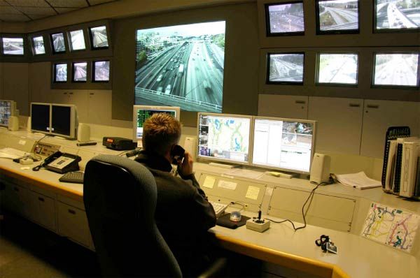
Table of Contents
Summary                                                              3

Brief History of ITS Deployment                                      5

Vision and Goals                                                     6
   Moving Washington and
   WSDOT’s Strategic Plan

The Current State of Deployment                                      8
   ITS Plans and Architectures                                       9
   Traffic Management Centers                                        9
   Field Devices                                                     11
   Communications Systems: Fiber Optic                               12
   Communications Systems: Wireless                                  12
   Traveler Information Systems                                      13
  Data Collection and Management                                     14
   Freight and Intermodal Systems                                    14

Future Plans                                                         14
   Provide an Integrated Network of Transportation Information       14
   Improve Safety and Crash Avoidance                                19
   Improve the Detection of Incident Occurrence and Severity,
      Notification and Response                                      23
   Providing Advanced Transportation Management                      25

Prioritized Project List                                             29

The Long View                                                        31

Appendix A                                                           A-1

Statewide ITS Plan – Final             2                         April 1, 2009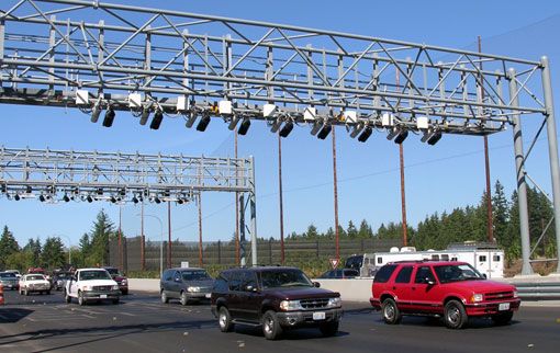
Summary
Intelligent Transportation Systems, or ITS, improve transportation safety and
mobility and enhance productivity through the use of advanced communications
technologies and the integration of advanced communications technologies into
the transportation infrastructure and vehicles. Intelligent transportation systems
encompass a broad range of wireless and wire line communications-based
information and electronics technologies.
The purpose of the Washington State Department of Transportation (WSDOT)
Statewide Intelligent Transportation Systems (ITS) Plan is to 1) identify the near-
and long-term ITS needs to meet the objectives identified in WSDOT’s 2009-2015
Strategic Plan and Moving Washington, WSDOT’s vision of investments and
priorities over the next 10 years; and 2) to identify specific ITS projects designed to
implement strategies identified in
Moving Washington.
The Statewide ITS Plan is a comprehensive document that discusses:
The history of ITS deployment in Washington
How ITS meets the WSDOT’s transportation vision and goals
The current state of ITS deployment
WSDOT’s near-term ITS plans
How projects listed in Appendix A were prioritized, and
What long-term ITS issues WSDOT needs to begin planning for.
Key ITS investments are required to make portions of the Strategic Plan and
Moving Washington successful. These key areas include:
1. Expanding ITS communication capabilities for delivering real-time
information to the travelling public, our local agency partners, media and
other users of transportation data WSDOT generates.
2. Installing ITS field devices and incident response vehicles in new locations,
and replacing aging devices that are becoming obsolete.
3. Upgrading Traffic Management Centers (TMCs) in the Northwest, Olympic
and South Central regions so they can better manage traffic demands.
4. Building upon WSDOT’s successful ITS investments by implementing Active
Traffic Management (ATM) techniques along our most congested corridors.
5. Continuing to monitor and participate in evolving ITS technologies and
programs such as the Federal Highway Administration’s (FHWA’s) Vehicle
Infrastructure Integration (VII) effort.
Investing in equipment and personnel necessary to operate and maintain
WSDOT’s existing and future ITS program.
Specific projects are listed in Appendix A. They are divided into two categories: a
Statewide ITS Plan – Final 3 April 1, 2009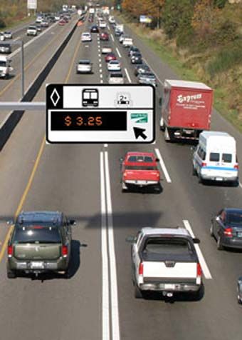
prioritized list of projects that should be underway in the 2009-2011 biennium, and
a second list of projects for the 2011-2019 timeframe. All are critical to the success
of WSDOT’s Moving Washington initiative.

Statewide ITS Plan – Final                4                              April 1, 2009
I. A Brief History of ITS Deployment
Intelligent Transportation Systems (ITS) are the application of computers,
communications and sensor technology to surface transportation. Most
transportation agencies began using technology to manage transportation
problems long before the term ITS became popular. Most of these efforts were
directed towards the relief of urban congestion. Freeway management systems
and coordinated traffic signal systems were installed to improve the efficiency of
urban freeways and arterial roadways. The Washington State Department of
Transportation (WSDOT) was an early proponent of these techniques, particularly
in the Seattle area, where it was, and continues to be, prohibitively expensive, due
to geographical constraints, to add freeway lanes. Instead, WSDOT used freeway
management techniques like ramp metering and operational strategies like High
Occupancy Vehicle (HOV) lanes to try to squeeze the maximum efficiency from the
freeway system.
Today’s improved capabilities in computers, communications and sensors allow
the application of ITS in places and ways that weren’t previously feasible. In 1993,
WSDOT prepared an Intelligent
Vehicle Highway Systems (IVHS
was the forerunner of ITS)
Strategic Plan for Washington
State, called “Venture
Washington”. The plan provided
geographically focused recommendations in five categories based on an
assessment of problems throughout the State. Those categories were:
Public Transit and Transportation Demand Management
Traveler Information
Traffic Management
Freight and Fleet Management
Additional Services (emergency services, enforcement, safety and
security)
In 1996, WSDOT prepared an ITS Six-year Action Plan that developed specific
project recommendations based on the general recommendations of the IVHS
Strategic Plan. In the ten years that followed the preparation of the Action Plan,
much progress in the installation of ITS infrastructure occurred. The funding source
for much of this infrastructure, particularly the infrastructure installed in rural areas,
was federal ITS deployment funds provided through Congressional earmarks. The
Washington State Legislature provided state matching funds for these ITS
earmarks that made it possible for WSDOT to utilize the funds. Federal fiscal year
(FY) 2005 was the last year that the US Congress provided ITS earmarks.
A great deal of the urban ITS infrastructure, particularly on Seattle area freeways,
was installed as part of freeway reconstruction or HOV lane construction projects.
For example, the first WSDOT fiber optic communications cable was installed in
Statewide ITS Plan – Final 5 April 1, 2009
the 1990s as part of the replacement of the Interstate 90 floating bridge in the
Seattle area.

Twice in the past 5 years, the Washington State Legislature
has voted to increase the gas tax to fund transportation
improvements. These funds are allocated for a long list of
improvement projects proposed for every state highway
across Washington State. With the demise of the ITS
earmarks, WSDOT now needs to incorporate ITS work into
these improvement projects in the same way that this work
was added to Interstate Highway construction projects. In     Moving Washington is
order to do this, a detailed ITS plan is required to identify a three-part strategy
the statewide ITS needs by location and priority.                to reduce traffic
                                                                   congestion in our
                                                                        state.
This plan will provide explanations for the installation of ITS
infrastructure and the benefits to be expected.

II. Vision and Goals: Moving Washington and WSDOT’s Strategic Plan

Moving Washington is a three-part strategy to reduce traffic congestion in our
state. The strategy details three complementary elements: adding capacity
strategically, efficiently operating the existing system, and providing choices that
help manage demand.
                                                              WSDOT’s Business
                                                              Direction: Move people,
Advanced technology, or ITS, is one of the key tools in       goods, and services
two of the strategic elements: operating efficiently and      reliably, safely, and
managing demand. While Moving Washington and the              efficiently, by adding
Strategic Plan discuss goals and objectives for               infrastructure capacity
                                                              strategically, operating
improving traffic in Washington state, this ITS Plan
                                                              transportation systems
discusses how ITS will be used to meet those goals. In        efficiently, and managing
addition, Appendix A lists specific ITS projects WSDOT        demand effectively.
must implement to realize the benefits envisioned in
Moving Washington and the Strategic Plan.

Operating efficiently means getting the most out of the infrastructure we already
have. Much of this is done using relatively low cost traffic ITS technologies such as
electronic tolling, Traffic Management Centers (TMCs), traffic cameras and other
surveillance devices, Variable Message Signs (VMS), Highway Advisory Radios
(HAR), and ramp meters.

Managing demand means promoting and sponsoring travel options for travelers
that result in greater efficiency for the transportation system. ITS strategies to help
manage demand include real-time traffic information displayed for drivers on
variable message signs and variable tolling based on traffic volume or time of day.
These options shift demand away from the parts of the system that are
overburdened, on a particular route or at a particular time of the day.

Statewide ITS Plan – Final                 6                               April 1, 2009
Deploying ITS components identified in Moving Washington and listed in this plan
supports the following objectives of WSDOT’s 2009-2015 Strategic Plan:
1.8 - Continuity of Operations and Emergency Management and Response:
Increase WSDOT’s ability to respond to, recover from, and deliver vital services
during emergencies and disasters.
Business 2.1 - Highways and Bridges Maintenance: Maintain
highway and bridge systems to optimize their short and
long-term usefulness and minimize life-cycle costs.
Directions: 2.10 - Traffic Operations Equipment Preservation and
Upgrades: Preserve and upgrade traffic operations
WSDOT’s
equipment, such as traffic signals, variable message
signs, and information technology and communications
systems, to meet existing and future highway
2009-2015 operations needs.
3.3 – Traffic Management (Operating Efficiently):
Strategic Plan
Optimize efficiency of the existing system by improving
and expanding traffic management to increase the
operating capacity of highways and reduce the causes
and severity of congestion.
3.4 – Traveler Information (Operating Efficiently):
Provide user-focused information so the public can
make informed decisions about when, where and how to travel – “all roads, all
modes, all the time.”
3.5 – Variable Tolling (Managing Demand): Provide funding for highway and bridge
improvements, and make more efficient use of available roadway capacity through
the use of high occupancy toll (HOT) lanes and express lanes.
3.6 – Demand Management (Managing Demand): Increase vehicle occupancy and
use of transportation services and commute choices.
3.7 – Highways and Ferries Operations (Operating Efficiently): Monitor, analyze,
and report performance of highways and ferries system operations. Expand “real
time” monitoring and analysis of highways and ferries to support travel decisions
made by the public, better manage operations, and improve system performance.
4.3 – Climate Change: Reduce transportation contributions to climate change.
Address impacts of climate change on transportation infrastructure and operations.
As mentioned previously in the discussion of the 1993 IVHS Strategic Plan for
Washington State, WSDOT focused resources on several categories of projects.
ITS projects have always suffered from a need to emphasize the technologies that
must be implemented before a benefit can be realized. Often a considerable
amount of infrastructure must be deployed before an application that provides
tangible benefits can be introduced. The following are the areas where national
and WSDOT experience indicate that ITS can provide the most benefit to the
Statewide ITS Plan – Final 7 April 1, 2009transportation system:
Provide an integrated network of transportation information. This
includes real-time information on the physical state of the infrastructure,
how it is being built, used, maintained and kept secure, as well as its
environment, including relevant weather conditions and predicted
conditions.
Improve safety and crash avoidance. This can
be accomplished by providing real-time traveler “The core strategies to
accomplish these goals
information on collisions. This will result in include expanded use of
fewer secondary collisions as motorists avoid TMCs . . .”
the crash scene. It also involves the
development, integration and deployment of in-vehicle electronics,
vehicle and highway automation and selective automated enforcement,
including the determination of fitness to drive.
Improve the detection of incident occurrence and severity, notification
and response. This involves providing public safety responders with
timely notice of an incident, efficiently routing them to the scene and to
the hospital, and giving them the ability to assess and convey the nature
and degree of injury to the travel center.
Providing advanced transportation management. This involves area-wide
surveillance and detection, rapid acquisition of traffic flow data, real-time
evaluation of traffic flows, predictive capabilities and evaluation of
operational strategies. Active Traffic Management, Integrated Corridor
Management and Congestion Pricing Strategies are all part of this effort
and are described in more detail in later sections.
The core strategies to accomplish these goals include expanded use of TMCs to
actively manage traffic; more widespread use of field devices such as ramp
meters, highway advisory radios, variable message signs, surveillance equipment,
and road and weather information systems; new communications systems
including fiber optics and wireless technologies; innovative traveler information
systems; additional data collection and management tools; and improved freight
and intermodal systems.
III. The Current State of Deployment
NOTE: The following discusses the current state of deployment in general terms. A
detailed inventory of ITS deployments and devices is not included. The reason for
this omission is to avoid making a document that is obsolete as soon as it is
published. The current ITS inventory is located on WSDOT’s GIS Workbench
(http://wwwi.wsdot.wa.gov/GIS/supportteam/gis_workbench/default.asp).
Statewide ITS Plan – Final 8 April 1, 2009ITS Plans and Architectures
WSDOT was one of the first state
departments of transportation to
develop a statewide ITS plan (1993).
This provided general guidance to set
the direction of WSDOT’s ITS
program. It was followed by a Six-Year
Action Plan (1996) that provided more
specific guidance for the program. As
the opportunity to attract increased ITS
earmark funding arose, WSDOT’s six
regions developed project lists and
implementation plans. Because federal
funds were involved in these projects, it also meant that an ITS Architecture was
required. ITS architectures were first developed in the following areas of the State
that include most of the major urban areas:
Spokane County (Spokane)
Clark County (Vancouver, WA)
The four counties of central Puget Sound:
Kitsap, King, Pierce, and Snohomish Counties (Seattle and Tacoma)
Thurston County (Olympia)
Whatcom County (USA/Canada border area)
In 2001, FHWA and FTA implemented the TEA-21 requirement that all ITS projects
using federal funding must conform to the National ITS Architecture and ITS
technical standards. The Washington State ITS Architecture and Regional ITS
Architectures for WSDOT’s North Central and South Central Regions were
developed in 2002, and updated in July 2006. An ITS 10-Year Vision Plan (2005-
2014) was prepared in 2005 for inclusion in the 2005-2015 Maintenance and
Operations Plan. This plan updates the 2005 effort.
Traffic Management Centers
WSDOT currently has traffic management centers
(TMCs) in each of its six regions. Centers are
located in:
The Seattle area (actual location in
Shoreline)
The Tacoma area (actual location in
Parkland)
Spokane
Vancouver
WSDOT Seattle Area Traffic
The Yakima area (actual location in Union
Gap) Management Center
Wenatchee
Bellingham
Statewide ITS Plan – Final 9 April 1, 2009In addition, the South Central Region operates a traffic operations center at Hyak, responsible for coordinating winter operations on Snoqualmie Pass with the Union Gap TMC. Current efforts are underway to design a new, combined Seattle area TMC and emergency operations center (EOC) that will be located at WSDOT’s Shoreline facility. The TMCs have somewhat different missions, based on their local environment and populations. The Seattle, Tacoma, Spokane and Vancouver TMCs focus on freeway management. The Northwest, Olympic, Southwest and Eastern Regions are dominated by Interstate Highways: I-5 for the first three and I-90 for the last one. The Seattle area TMC is the only one that operates an extensive ramp metering system. The Tacoma area TMC operates WSDOT Wenatchee Traffic several ramp meters on the SR 16 approach Management Center to the Tacoma Narrows Bridge and one meter on I-5. Of all of the WSDOT TMCs, the Spokane TMC is the only one that has a significant role in operating a traffic signal system. It is also the only one that is operated as a partnership of six transportation agencies in the region. These agencies are the City of Spokane, City of Spokane Valley, Spokane County, the MPO, Spokane Transit and WSDOT. The Tacoma, Vancouver and Yakima TMCs are co-located with the Washington State Patrol (WSP). All of the TMCs play a major coordinating effort in incident management. In all cases, except for the Bellingham TMC, the Region radio communications room is located at the TMC. These coordinate communications with WSDOT Maintenance (including Incident Response) and Construction resources and the Washington State Patrol. The Yakima area and Wenatchee TMCs are also involved in coordinating incident response but their major focus is the coordination of maintenance efforts to keep the State’s mountain pass highways open during the winter. The focus of the Bellingham TMC is primarily coordination of the expanding system designed to provide border crossing wait times and other travel information to those heading north to Canada. As a result of these different emphasis areas, the software used in these systems is different. The Seattle area software is custom developed to operate their ramp meter algorithm. The Spokane area software is “commercial off the shelf” and runs the area’s traffic signal system. The Vancouver, WA TMC software will eventually be compatible with the software that the Oregon Department of Transportation Statewide ITS Plan – Final 10 April 1, 2009
uses to operate its TransPort freeway management system in the Portland area.
In Spokane and Vancouver, the priority to coordinate with regional partners was,
and is, higher than that to be compatible with other WSDOT TMCs.
This diversity of missions and the accompanying software, in addition to the large
geographical distances between TMCs, has made it difficult to achieve center-to-
center communications and standardized operating procedures. Various efforts are
underway to remedy this situation. WSDOT is
using xml as a standard for communicating
between TMCs. The NW Region is
implementing a regional project, called Traffic
Busters, which will allow approximately 20
agencies in the central Puget Sound to connect
to the WSDOT fiber optic network and
exchange traffic video. This project will lead the
way in center-to-center communications and
will serve as a model for exchanging data and
information, both between WSDOT centers and
between WSDOT and local agency centers. In
Highway Advisory Radio Transmitter
addition, WSDOT has provided research funds
for the Washington State Transportation Center
(TRAC) to recommend a method of archiving statewide data such as traffic
volumes, lane occupancies, speeds, incidents and weather data. TRAC has
prepared a Request For Proposals (RFP) for the purchase or development of the
recommended archive system called Performance Measurement Systems (PeMS).
In order for this data archive to operate, data exchange standards will be needed
between HQ and the region TMCs.
In order to standardize operating procedures between TMCs, TMC operators hold
periodic meetings lead by the ITS Field Operations Engineer. In the NW Region,
the Puget Sound Regional Council is leading an effort to develop a “regional
concept of operations for regional operations”. It will be used when the Traffic
Buster project is complete and agencies have the ability to share data and, in some
cases, control of traffic signal systems.
Field Devices
WSDOT manages its roadways with a fairly standard array of field devices. These
include ramp meters, closed-circuit TV cameras, loop detectors, highway advisory
radios, variable message signs, and road weather information systems. There are
a small number of video detectors and radar detectors in use around the State.
The following table gives the estimated number of field devices deployed in the
State:
Freeway loop detectors = 5,000
Video detectors = 15
Radar detectors = 25
Traffic signal loops = 15,000
Statewide ITS Plan – Final 11 April 1, 2009 Closed-circuit TV cameras = 500
Ramp meters = 170
Highway advisory radio transmitters = 60
Variable message signs = 180
Road weather information systems = 95
In addition to these systems, WSDOT has deployed other
systems on a limited basis. Some examples of these
deployments are:
License plate readers to provide arterial road
travel times
Toll tag readers for the Tacoma Narrows Bridge
and the SR 167
HOT lanes
Variable speed limit systems that set speed
limits based on weather or road conditions are
in operation on I-90 and US-2 where they cross
mountain passes
The current inventory and locations are located on the
GIS Workbench
SR 167 HOT Lanes
(wwwi.wsdot.wa.gov/GIS/supportteam/gis_workbench/def
ault.asp).
Communications Systems: Fiber Optic Cable
WSDOT has over 160 miles of fiber optic communications cable installed within
state highway right-of-way. Most of this is in the Seattle area but fiber is also
installed in the Spokane, Tacoma and Vancouver areas. This fiber is used to carry
data and video images between the field devices and the TMCs. The fiber system
is primarily an analog system that supports both analog and digital transmission.
Most of the system uses single mode fiber with a small percentage being multi-
mode. The Seattle area fiber network was designed to use
SONET technology built in rings but the ring topology has
not been completed.
Communications Systems: Wireless
WSDOT has an 800MHz wireless radio system for voice
communication with its field personnel. There are also direct
connections, in most cases, between WSDOT TMCs and
WSP dispatch centers. (As mentioned previously, the
Vancouver, Yakima and Tacoma TMCs are collocated with
WSP facilities.) There is nearly complete coverage of the
state highway system. There is, however, no wireless data
transmission system. As noted previously, there are radio
rooms located in 6 of the 7 TMCs. Five of these operate
24/7 and one, Wenatchee, operates only during normal WSDOT Wireless 800 MHz
Radio Tower
Statewide ITS Plan – Final 12 April 1, 2009working hours. The Bellingham TMC is the only one that lacks a radio room.
WSDOT is part of a national effort to reband public agency radio networks from the
800MHz frequencies to spectra in the 700MHz band. This is being done to
eliminate interference between the public agencies and various private sector cell
phone providers that also use spectrum in the 800MHz band. Since they are the
cause of the interference, the private sector companies have been directed to pay
for this rebanding effort in exchange for the use of the public agency 800MHz
spectrum. The first phase of this rebanding effort is a three-year planning phase
that starts in January 2008. The rebanding effort may facilitate the required
migration to a P25 digital trunking system that will provide some interoperability
with law enforcement and other agencies. This effort will replace a great deal of
existing outdated infrastructure and equipment with the latest technology in radio
systems but falls short of making necessary upgrades and expansions to the
system.
WSDOT’s ITS and Wireless Communications group is also exploring ways to
provide wireless bandwidth for data transmission. Work is underway to test a low
speed 700MHz system with some 4.9GHz high speed hot spots. A pilot project in
the North Central Region is scheduled to take place in 2008-2009.
Wireless communication does provide a small number of critical links in the ITS
system. Some of the key systems around the state utilizing wireless
communications include the Tacoma Narrows Bridge traffic cameras, a Benton
County Emergency Services/Yakima TMC connection to distribute video and data
along I-82, cameras to support the movement of nuclear waste from the Port of
Hanford near the Tri-Cities, and improved traveler information along the
U.S./Canada border to support the 2010 Winter Olympics in Vancouver, B.C.
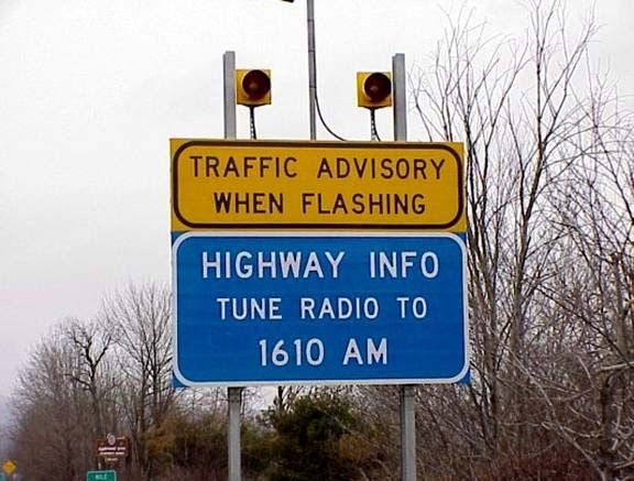
Traveler Information Systems
WSDOT uses traditional tools for delivering traveler
information, such as Highway advisory radios and
variable message signs. In addition, WSDOT also
provides Internet-based travel information
(www.wsdot.wa.gov/traffic/) and telephone-based travel
information (511). Congestion maps are available on the
web site for Seattle, Spokane, Tacoma, and Vancouver.
Versions of the congestion map are available for use on
web-enabled cell phones and PDAs on the WSDOT
website (www.wsdot.wa.gov/small). Many other types of travel information are
provided on the WSDOT web site. Some examples are:
Travel times
Closed-circuit TV images
Incident information
Construction traffic impacts
Statewide ITS Plan – Final 13 April 1, 2009 Weather information (both current and predicted)
Road conditions – including mountain pass reports
USA/Canada border crossing delays
Variable message sign and highway advisory radio message content
Data Collection and Management
WSDOT has an extensive archive of freeway volume and lane occupancy data as
well as an extensive archive of HOV lane volume, vehicle occupancy and travel
time data. These data are available from the Washington
State Transportation Center (TRAC) or from WSDOT.
Various customized data reports can be prepared that
depict speed, delay or congestion. The public can use the
WSDOT web site to see archived versions of the Seattle
area FLOW map dating back to January 2005. The
Eastern Region uses a vendor developed data archive
and management system called the Performance
Management System (PeMS) that can also display traffic
volumes, speed, delay and congestion.
Weigh in Motion System
Freight and Intermodal Systems
WSDOT has installed the Commercial Vehicle Information Systems and Networks
(CVISN) technology, including weigh-in-motion systems, at 11 locations in
Washington (on I-5, I-82 and I-90). Vehicles equipped with CVISN transponder
tags can bypass weigh stations if they are of legal weight and pass registration and
safety scans. The truck is weighed at freeway speeds and a tag reader identifies
the truck. National and state databases are scanned for over a dozen parameters
to see if the truck has complied with registration, tax and safety requirements. If so,
the truck is given a green light to bypass the weigh station. If not, the truck is given
a red light and must pull into the weigh station for further scrutiny. There are
approximately 51,000 transponders in use by 6,990 carriers.
WSDOT has also conducted operational tests that explored the use transponders
to assist with the US Customs and Border Protection inspection process at the
USA/Canada border. A test of the use of electronic container seals for container
security and tracking has been underway for several years.
IV. Future Plans
The following sections discuss WSDOT’s future plans in each of the four ITS areas
that have the potential to deliver the greatest benefits.
1. Provide an integrated network of transportation information.
Opportunities: WSDOT recognizes its obligation to collect and disseminate real-
time information on the physical state of the infrastructure, how it is being built,
used, maintained and kept secure. Information on the environment that surrounds
that infrastructure, including relevant weather conditions and predicted conditions,
is also important to collect and disseminate. It is important to note that security
Statewide ITS Plan – Final 14 April 1, 2009concerns may restrict the dissemination of some infrastructure-related information. This network of information is the foundation upon which all aspects of transportation management are built. It permits agencies to efficiently manage both the physical infrastructure and the operations that use that infrastructure. It enables agencies to identify safety risks and mitigate them. It allows travelers to make informed choices on the best route, both in advance and en-route, based on real- time and predictive information. It helps shippers, carriers and freight terminal operators interact to move freight in the most efficient way possible. Engineers have always collected and analyzed information about the transportation system. ITS provide additional tools for information collection and use. However, information about the transportation system remains sparse, fragmented and uncoordinated. More and different types of data are needed. Some examples are: arterial traffic volumes and speeds, system-wide travel times for cars, transit and trucks, infrastructure status for security and for programming maintenance or replacement, and true pavement surface conditions. The good news is that the strong foundation for the collection, analysis and dissemination is in place. Data based performance measurement has become an integral part of WSDOT management philosophy. The future direction is to build on this foundation by installing more data collection devices and more communications capability, developing more analysis capability and delivering more traveler information. Benefits: An information system, by itself, does not deliver direct benefits. But the information that it generates can result in improved system operations and improved travel information. The benefits in system operations are realized through improved system management, both during daily events and when crises occur. Improvements in travel information can result in improved operations also as travelers choose an alternate route, time of travel or mode of travel. Even if it is not feasible to make any of these changes, improved travel information can result in reduced stress due to less uncertainty during travel. Improvements in personal mobility can also be realized when people have greater control over their travel. For example, people may use travel information to combine several errands into one trip, thereby gaining greater Statewide ITS Plan – Final 15 April 1, 2009
benefit from their travel. Improved travel information enables freight movers to
improve the reliability of their trips leading to reduced transportation costs and,
therefore, reduced overall costs for goods. Along with improved operations and
travel efficiency comes improved safety. As drivers use information to avoid
incident locations, they reduce their chances of being involved in secondary
collisions. There is also an intangible but significant element. In this information
age, increasingly the public simply wants to know the conditions they will encounter
on their trip. To the traveler, even the smallest amount of information is valuable.
Just an awareness of what to expect and a
description of the congestion ahead provides
the traveling public with peace of mind and the
perception of a safer, more secure trip.
Studies, and feedback WSDOT has received,
suggest there is value in providing what our
customers expect, even though the system
benefits cannot be easily measured.

Challenges: As with almost all aspects of
transportation operations, the challenges to
achieving improved information integration are
almost all institutional or jurisdictional in nature.
Incentives do not exist, in many cases, to
convince people of the value of sharing data.
Data collection, communications, database
management, travel information, etc, are not
considered of sufficient importance for more
than relatively minor amounts of funding to be
spent on them.

The lack of monetary benefits that can be
assigned to improvements in travel information
is also a problem. The reduction of stress due
to less uncertainty is a good example. The
stress reduction may result in fewer road rage
incidents but, so far, it has been impossible to
quantify those benefits.

WSDOT was one of the first agencies in the
country to offer freeway congestion information
to the public. Initial efforts provided Seattle area
travel information to the local radio and TV
traffic stations and they augmented it, in some
cases with reports from their own traffic
reporters or those of commercial traffic
reporting companies, and delivered it to the
public. WSDOT worked to maintain good
relations with the traffic reporting media and

Statewide ITS Plan – Final                   16                        April 1, 2009
recognized the important role that they played in delivering information to the
public. As technology made it possible for WSDOT to economically deliver the
information that it collected for traffic operations to the public, it began to deliver
information using the Internet, telephone hotlines and television.

From the early days of IVHS to the present, traveler information has always
provided a tantalizing business opportunity for technology companies. Early on
business success did not live up to expectations with various companies
attempting different types of delivery and business models of which most failed.
However, one company, Westwood One with its combined Metro/Shadow
Networks traffic broadcasting service developed a business model that has
succeeded nationally and endured for several decades. Some relatively new firms,
like Inrix and Traffic.com, appear to have developed business models that may
succeed. With the integration of traffic information in in-vehicle guidance systems
that provide route choice options and the availability of additional forms of traveler
information such as travel times, border crossing delays, and video we should
continue to see traveler information business opportunities expand. We would
expect to see businesses delivering traveler information continue to slowly grow
into the future.

The idea of turning over the delivery of travel information to the private sector has
been an attractive one for state departments of transportation. Government
agencies have trouble keeping up with the latest technology and are usually
unsuccessful in efforts to market their services. Each new firm has tempted various
state DOTs to form partnerships to deliver travel information. WSDOT joined forces
with Seiko to deliver en-route travel information via the Seiko pager watch and with
Microsoft to deliver information as part of its Sidewalk travel information web site.
Neither of these companies offers these services today. WSDOT is currently
working with Traffic Gauge to deliver information on their handheld traffic device.
WSDOT’s attempts to work with the private sector have focused on offering
customers something different or better than what is currently provided. The
motivation in the case of the Seiko watch or the Traffic Gauge device was en-route
travel information that was more frequent and better than what was available over
the car radio. Personalized travel information was the motivation in the case of the
Microsoft web site. Live, full-motion video available on a handheld device is the
motivation of the current discussions mentioned above. This tremendous industry
turnover has left most state DOTs wondering how the public and private sectors
should work together on travel information and what the respective roles of each
should be.

The prevailing view seems to be that the public sector role is to install, maintain
and operate the infrastructure that is needed to operate and monitor the
performance of the transportation system. In most states and/or urban areas, the
public sector has chosen to offer a basic level of free travel information using
technology that can be added to its transportation operations systems at little
incremental costs. Thus WSDOT, like many other state departments of
transportation, offers the public a version of the congestion map that it uses to

Statewide ITS Plan – Final                  17                               April 1, 2009
monitor traffic conditions. This is available over the Internet at the cost of an
increasing number of servers to handle an increasing volume of users. The
information is also available over the telephone by dialing 511, which is also driven
by the data that is collected for operations purposes. As these systems attract
larger audiences, the costs for these services become greater, causing most DOTs
to constantly reassess whether they or the private sector should be providing these
services. The flux in the industry has kept the public sector in this business, and
customer feedback indicates that the public supports keeping this effort publicly
funded with little or no advertising.
The private sector has focused on providing a type of “premium” travel information
service. They have tried delivering the information on devices that are simpler,
faster or more convenient than the telephone or a laptop or home computer
browsing the Internet. They have tried offering the ability to customize the service
by letting the user specify the type of information that is desirable (time of day,
route, and level of disruption).
WSDOT’s direction in the area of travel
information will be to continue to offer a
comprehensive, accurate, real-time, free,
basic level of travel information using as
many media as possible. WSDOT will look
for ways to offer both pre-trip and en-route
travel information, realizing that with current
technology it is difficult to deliver en-route
information that is timely enough to be used
by travelers. WSDOT will continue to
support the efforts of the private sector to
deliver an improved or premium level of traveler information. WSDOT should
explore, however, the use of private server- farms or an Internet Service Provider
to provide the peak period capacity that it requires during emergencies when the
public demand for travel information increases by four to six times. Some states
are electing to contract with private companies for travel information. One such
company, INRIX, combines public sources of real-time and historical data with toll-
tag data and GPS-strobe vehicle data from a fleet of commercial vehicles like taxis
and delivery vehicles to provide real-time and predictive traffic and speed
information.
Actions: Section V references a project
list, included in Appendix A. The priority
projects listed are identified in the
“Operating Efficiently” and “Managing
Demand” strategic elements of Moving
Washington. However, Moving
Washington does not identify any
statewide projects. The key statewide
traveler information projects are listed
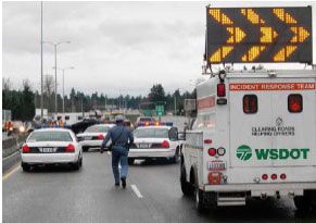
WSDOT Incident Response and WSP
Statewide ITS Plan – Final 18 April 1, 2009below.
As the most comprehensive source of both pre-trip and en-route travel
information, the 511 telephone hotline is an important resource for
WSDOT. An upgrade of the system is badly needed. The new system
would be a portal for travel information, including information on transit
and other modes. It should also have improved computer-generated
voice and improved caller ID that would allow other personalization
features.
Work is underway to develop the functional requirements for an
improved travel information web site but the project has no funding. This
upgrade should include a new version of the Condition Acquisition and
Reporting System (CARS) for recording and displaying information on
statewide incidents and weather- or construction-related closures. This
improved travel information system would provide users with the ability
to develop their own travel information web page so they could quickly
access the WSDOT information that is of most interest to them. The
website should also provide users with the capability to plan trips by
entering an origin and a destination and giving them the ability to
compare travel times by different modes.
Research: The following are key research topics in this area:
Develop a method to quantify the mobility and safety benefits of providing
traveler information.
Develop a standard way to display arterial traffic congestion on a map.
Test new sensors that can determine road surface conditions for accuracy and
reliability.
Policy: The key policy initiative is for WSDOT to understand its role as a regional
and statewide information provider. It manages a large communications
infrastructure and collects a large quantity of valuable information that is in great
demand. WSDOT should realize that an important part of its overall mission should
be to provide its customers with comprehensive travel information that is integrated
with that of other agencies, including agencies that manage other modes.
WSDOT also should take the lead in promoting the sharing of data. For travel
information to be maximally useful, the public needs a one-stop-shop for travel
information. This requires local agencies to share data and provide data in a
standard format so it can be displayed on an integrated web page. WSDOT should
assist local agencies with those efforts.
2. Improve safety and crash avoidance.
Opportunities: WSDOT, along with the Washington Traffic Safety Commission,
Washington State Patrol, Department of Licensing and other safety partners,
developed a strategic highway safety plan, Target Zero, to reduce traffic fatalities
Statewide ITS Plan – Final 19 April 1, 2009to zero. This involves a
comprehensive program of
enforcement, education and
engineering. Many experts believe
that engineering improvements
are reaching the limit of what can
be achieved to make the roadside
and the vehicle safe. Freeway
median barrier, impact attenuators, seat belts, front and side airbags, and traffic
signal all-red intervals have succeeded in reducing the fatality rate to the lowest in
history. But there are still over 40,000 fatalities in the US annually. Work currently
underway indicates that ITS can shift the emphasis away from surviving a crash to
avoiding it. Using in-vehicle warning and control systems, ITS can offer a way to
significantly reduce the number of fatalities and help achieve the Target Zero
goals.
ITS can help drivers avoid hazardous mistakes by minimizing distraction, helping in
degraded driving conditions and providing warnings or control in imminent crash
situations. ITS can also improve safety by automating the enforcement of traffic
laws.
To achieve the expected safety improvements, the majority of new technology is
expected to be installed in the vehicle. There are at least four kinds of in-vehicle
electronics products that are of interest:
Information products such as route guidance and traffic advisories
Diagnostic products such as low tire pressure warnings and cargo
security
Driver assistance products such as curve speed warning, collision
warning, stability control and lane departure warning
Active safety products such as forward and rear collision avoidance and
lane departure prevention.
Many of the applications made possible by these products will depend on, or will
perform better if furnished with, data from the roadside, a traffic center or other
vehicles. In addition, the sensors in these vehicles will also provide a source of
data for many transportation operations applications. Data on speeds, travel times,
traction or road surface conditions and collisions will be available to traffic
management centers from a large stream of probe vehicles. Clearly, some
interaction between vehicle and roadside systems, requiring some public sector
infrastructure, will be needed in the future. The question that is likely to remain
unanswered for the next 5 to 10 year concerns the balance between vehicle based
and infrastructure based systems. FHWA is attempting to provide guidance in this
area by leading the Vehicle Infrastructure Integration (VII) effort. WSDOT is one of
the states that is participating in that effort. We have formed a WSDOT VII Review
Team to support our involvement in the FHWA’s Federal Working Group. The
WSDOT team is working to develop deployment scenarios, primarily involving
commercial vehicles, which can be proposed to FHWA as candidates for
Statewide ITS Plan – Final 20 April 1, 2009operational test funding. Much work is underway to determine the full range of VII
applications and determine the costs and benefits of the implementation of this
technology. Additional information can be found at http://www.vehicle-
infrastructure.org/.
Technology could also improve safety through the automated enforcement of traffic
laws.
The following are some examples:
Ignition interlocks that require a valid drivers license to start the car
Ignition interlocks that test blood alcohol levels or other tests to prevent
impaired or drowsy drivers from starting the car
Automated hours of service monitoring and reporting systems for truck
drivers
Automated red-light running, highway-rail crossing and speed
enforcement, including speed enforcement in construction or
maintenance work zones. (The legislature recently gave WSDOT the
authority to conduct a test of work zone photo speed enforcement on
state highways.)
It is also important to note that the delivery of real-time
travel information concerning collisions and other non-
recurring delays can improve safety by reducing
secondary collisions as motorists use the information to
avoid traffic jams.
Benefits: Improving safety saves lives, time and money.
Emphasizing crash avoidance rather than crash survival Work Zone Photo
will maximize the savings in all three categories. The Speed
envisioned systems can potentially provide additional
access and mobility for elderly or disabled drivers. Some of these in-vehicle
systems can also help to save fuel and reduce emissions by smoothing
acceleration and deceleration (particularly for trucks and transit vehicles) and by
enabling trucks or transit to operate in platoons.
The aggressive deployment of driver/operator license and impairment checks could
result in the elimination or reduction in severity of 50% of all fatal crashes.
Evaluations of red light running enforcement programs indicate that violations
decrease over time and related crashes at intersections are reduced by about
15%.
Challenges: Deployment of the crash avoidance and safety systems present the
greatest challenges to state departments of transportation of any ITS. The key
issue, as mentioned previously, is to achieve the optimal balance between in-
vehicle and roadside infrastructure; or between public and private infrastructure.
Optimal, in this case, refers to a system that achieves the maximum benefit in
improved safety with an acceptable cost in infrastructure deployment and
Statewide ITS Plan – Final 21 April 1, 2009maintenance.
Many other issues will need to be resolved before systems like this are widely
deployed. Some of these issues concern:
Liability – Who will be liable when a collision occurs because a system is
not working? Will there be an expensive forensic investigation to
determine if the roadside or the in-vehicle system malfunctioned and, if
so, who will pay for the investigation?
Human factors – What level of warning, assistance or control will be
acceptable? At what point do all the warnings, phone rings, navigation
prompts, and entertainment sounds cause so much distraction that they
cause collisions rather then prevent them?
Standards – What level of cooperation can be expected between the
many vehicle manufacturers and the 50 state departments of
transportation?
Communications –
What are the
communications and
computing requirements
to collect and process
all of the data that are
available from all of the
millions of potential
probe vehicles on the
roads? Do the benefits
of this data justify the
costs of collecting and
processing it?
Societal Issues – What level of regulation and enforcement does the
public support in order to improve safety? While there are laws against
driving without the proper credentials, impaired driving, speeding and
red-light running, and a great deal of resources are dedicated to
enforcement, the chances of being caught are low. In many cases, the
penalties are also low. In most cases, the enforcement takes place after
the fact, either via observation of the unlawful behavior or during a crash
investigation. ITS could change this situation if the public finds that the
savings in lives, time and money are more valued than perceived loss of
privacy and personal autonomy.
Actions: WSDOT representatives will continue to be involved in the FHWA VII
initiative and participate in model deployment projects as they become available.
Research: Most of the research needed to fulfill the promise of ITS in this area
would pertain to nationwide deployments and is likely to be funded by federal
transportation agencies. WSDOT, however, should investigate the following:
How should automated enforcement systems be deployed around the
Statewide ITS Plan – Final 22 April 1, 2009state to achieve the greatest safety benefit within societal norms?
How can the privacy of the public be ensured despite all the data on
travel behavior being collected by public agencies and private
companies?
How much probe vehicle data is enough and how much is overkill, given
the price of communications and computing infrastructure?
3. Improve the detection of incident occurrence and severity, notification and
response.
Opportunities: Getting
emergency response teams
to an incident scene as
quickly as possible is critical
to saving lives. In order for a
response to be effective, first
responders must:
Receive timely
notice of an
incident, including
its location and
characteristics
Receive
information that allows efficient routing to the scene and to a hospital
Be able to assess and share information on the nature and degree of
injury with the receiving medial facility
In addition, an effective response includes safe traffic management at the incident
scene. This includes returning traffic flow to normal as quickly as possible to avoid
secondary collisions in the traffic queue caused by the incident.
ITS can help achieve these goals. Both roadside systems, such as CCTV
surveillance cameras, and in-vehicle systems, such as mayday systems, can be
used to detect and locate a crash. Information about the location and severity of a
crash can be immediately provided to first responders. Various traffic management
and travel information systems can be used to keep traffic disruptions to a
minimum. For example, speed harmonization systems, generally included as part
of Active Traffic Management (discussed later) can help to reduce the stop-and-go
conditions caused by incidents and, therefore, reduce secondary collisions.
Navigation devices that incorporate real-time traffic congestion information can be
used to provide optimal routing to emergency vehicles. Emergency vehicle traffic
signal preemption systems can help to get emergency vehicles to the scene as
quickly as possible. Advanced communications technologies can be used to
connect responders at the scene with medical center trauma experts to share
information on the number and severity of injuries. Similar communications
technologies can be used to connect responders on the scene with hazardous
Statewide ITS Plan – Final 23 April 1, 2009materials experts in the event of a spill. The key to success in this emphasis area is interoperable and improved communications between public safety answering points (PSAPS – generally 911 call centers), first responders (generally emergency medical technicians (EMT) and or law enforcement), TMCs, and private telematics providers (On Star, for example.) It may also be necessary to include some agencies that are not usually involved in emergency response in order to prepare for natural or man-made disasters. Transit agencies, for example, would need to be involved in any large-scale evacuation of an urban area, or the Washington State Ferry System and the US Coast Guard might be involved in an evacuation over water during an earthquake when all roads leading from Seattle are impassable. Benefits: Quicker crash detection and emergency response will save lives. However, from a traffic perspective, the biggest benefit of improved emergency response is the reduction in delay and secondary collisions due to quicker, more efficient, and more coordinated emergency response. Challenges: There are good surveillance systems and communications coverage in most urban areas. In rural areas, however, where there is a longer emergency response time, and, therefore, the detection time is more critical, surveillance and basic communications, like cellular phone coverage, are limited. In these rural areas, quicker emergency response will require collaboration between the public and the private sectors. State agencies often own strategic high elevation sites that can be shared with private sector companies to provide communications in rural areas. The indication that an airbag has been deployed by a vehicle in a rural area that is received by a private telematics company, like On Star, can be relayed to a public emergency management agency to provide a response. Eventually, when the wireless phone system has the capability to automatically locate callers, this service will be provided to all cellular phone users. The crucial problem for WSDOT in this area is the procurement of an interoperable radio communications system that has enough bandwidth to carry WSDOT data, including video images. Several communications studies have been done to assess communications needs and propose a communications system to meet those needs. An effort began in 2008 to plan and implement the rebanding of the existing 800 MHz radio system but does not include any system upgrades or expansion. Without a wireless system with the bandwidth to transmit large amounts of data, WSDOT lacks the capability to send or receive data like traffic congestion maps, video images, position data or function data (snowplow up or down, deicer spreader on or off) between vehicles and a TMC. (As mentioned previously, WSDOT is conducting a pilot project using a 700MHz/4.9GHz system for data transmission.) Without this ability to track and truly dispatch incident response and maintenance vehicles, WSDOT’s ability to improve the efficiency and coordination of its incident response is limited. Actions: Section V references a project list, included in Appendix A. The priority projects Statewide ITS Plan – Final 24 April 1, 2009
listed are identified in the “Operating Efficiently” and “Managing Demand” strategic
elements of Moving Washington. The key statewide incident detection and
notification projects are listed below.
The list included in Section V includes a project to equip the South
Central Region’s maintenance vehicles with an automatic vehicle
location system. All other regions have shown an interest in equipping
vehicles, especially incident response vehicles, with an automatic vehicle
location system.
WSDOT should implement a true incident response dispatch system that
is compatible with the one that WSP uses. A combined WSDOT/WSP
dispatch system operated by WSP would provide the most effective and
coordinated incident and emergency management.
WSDOT should implement a statewide wireless communication system
that has the bandwidth to carry data, which would allow traffic congestion
maps or video images from traffic cameras to be viewed in vehicles.
Ideally this would be done in cooperation with the WSP in conjunction
with the implementation of the common dispatch system discussed
above.
Research: Research that can measure the benefits of providing interoperable
wireless communications is needed. A credible estimate of the efficiency gains
from tracking and dispatching emergency response vehicles and being able to
share data with WSDOT vehicles and those of other agencies is needed.
Policy: A funding source for communications projects like the deployment of a
statewide, wireless communications system for the agency needs to be identified
and prioritized.
4. Providing advanced transportation management.
Objectives: Future advances in technology in this emphasis area will be mostly
evolutionary rather than revolutionary consisting of new detector systems, new
surveillance systems and new communications technologies. More data will be
available for new algorithms to use to optimize traffic flow. The most revolutionary
new developments will take place in the way these systems are integrated and
operated.
WSDOT was an early implementer of advanced traffic management systems,
particularly freeway management systems, in an effort to maximize the throughput
of its geographically constrained roadway system in the central Puget Sound area.
The majority of the ITS infrastructure in the state is used to provide data and
management capabilities for the central Puget Sound area freeways, but the urban
areas of Tacoma, Spokane and Vancouver are also deploying freeway
management systems. As more roadways and greater stretches of existing
roadways come under management, the opportunities for cooperative and
coordinated management are increased. The Federal Highway Administration
Statewide ITS Plan – Final 25 April 1, 2009You can also read