Cascadia: Oregon's Greatest Natural Threat - Oregon.gov
←
→
Page content transcription
If your browser does not render page correctly, please read the page content below
The Oregon Resilience Plan – Cascadia: Oregon’s Greatest Natural Threat – February 2013                   1

1. Cascadia: Oregon’s Greatest Natural Threat

Introduction
When, not if, the next great Cascadia subduction zone earthquake strikes the Pacific Northwest, Oregon
will face the greatest challenge in its history. Oregon’s buildings, transportation network, utilities, and
population are simply not prepared for such an event. Were it to occur today, thousands of Oregonians
would die, and economic losses would be at least $32 billion. In their current state, our buildings and
lifelines (transportation, energy, telecommunications, and water/wastewater systems) would be
damaged so severely that it would take three months to a year to restore full service in the western
valleys, more than a year in the hardest-hit coastal areas, and many years in the coastal communities
inundated by the tsunami. Experience from past disasters has shown that businesses will move or fail if
services cannot be restored in one month; so Oregon faces a very real threat of permanent population
loss and long-term economic decline.

We cannot avoid the future earthquake, but we can choose either a future in which the earthquake
results in grim damage and losses and a society diminished for a generation, or a future in which the
earthquake is a manageable disaster without lasting impact. We need to start preparing now by
assessing the vulnerability of our buildings, lifelines, and social systems, and then developing and
implementing a sustained program of replacement, retrofit, and redesign to make Oregon resilient to
the next great earthquake. We know how to engineer buildings, roads, and power lines to withstand this
earthquake; the hard part will be to find the will, commitment, and persistence needed to transform our
state.

The Oregon legislature recognized the scale of this problem when it passed House Resolution 3 in 2011
(see Appendix I for details of House Resolution 3), noting the likely impact of a Cascadia earthquake and
the need for a plan to move the state towards resilience to that event. The Oregon Seismic Safety Policy
Advisory Commission (OSSPAC) was charged with developing a resilience plan, which is described in this
report. The report summarizes the science of Cascadia subduction zone earthquakes and estimates their
impacts; it then provides detailed analysis of the current vulnerability of our buildings and business
community, and our transportation, energy, communication, and water/wastewater systems. The report
defines the performance targets that each sector must meet to achieve adequate resilience, and
provides detailed recommendations for the actions required to meet those targets over the next 50
years.

How OSSPAC Developed This Plan
House Resolution 3 passed by the 2011 legislature directed OSSPAC to ”lead and coordinate preparation
of an Oregon Resilience Plan that reviews policy options, summarizes relevant reports and studies by
state agencies and makes recommendations on policy direction to protect lives and keep commerce
The Oregon Resilience Plan – Cascadia: Oregon’s Greatest Natural Threat – February 2013 2
flowing during and after a Cascadia earthquake and tsunami”. To meet this challenge OSSPAC first
defined what resilience would mean for Oregon:
Oregon citizens will not only be protected from life-threatening physical harm, but because of risk
reduction measures and pre-disaster planning, communities will recover more quickly and with less
continuing vulnerability following a Cascadia subduction zone earthquake and tsunami.
OSSPAC identified existing and ongoing earthquake resilience planning from San Francisco, California
(SPUR, 2009) and the State of Washington (Washington Seismic Safety Committee, 2012) as good
models to follow. These studies outlined an approach that included estimating the current earthquake
vulnerability of systems and structures, defining the performance standards that structures and systems
would need to meet over fifty years in order to be sufficiently resilient, and then identifying changes in
practice and policy that would help attain those performance standards. One difference for the Oregon
Resilience Plan was that it needed to encompass the entire state unlike the City of San Francisco study,
and that it focused on the Cascadia earthquake threat, unlike the Washington study which considered
multiple earthquake scenarios.
To complete the plan without funding and on a one-year schedule, OSSPAC chose to tap into volunteer
expertise from Oregon’s academic, professional, governmental and public communities. Over one
hundred volunteer experts drawn from a broad section of Oregon society were organized into eight
work groups to survey the following parts of the problem:
Cascadia Earthquake Scenario
Business and Workforce
Coastal Communities
Critical and Essential Buildings
Energy
Transportation
Information and Communications
Water and Wastewater
The purpose of the task group assigned to the Cascadia Earthquake Scenario was to develop a detailed
description of the likely physical effects throughout Oregon of a major Cascadia subduction earthquake
so that the other groups could assess the impact on their respective sectors. Each of the remaining
seven groups focused on one of the sectors of society or parts of the built environment listed above. The
Coastal Task Group was included to recognize the unique risk along the coast: this region will experience
a combination of tsunami damage and damage from extreme shaking.
Each group was charged with three primary tasks: First, determine the likely impact of the scenario
earthquake on the assigned sector and estimate the time required to restore functions in that sector if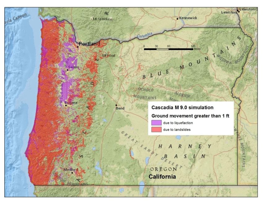
The Oregon Resilience Plan – Cascadia: Oregon’s Greatest Natural Threat – February 2013                  3

the earthquake were to happen under current conditions. Second, define performance targets for the
sector. The targets represent the desired timeframes for restoring functions in a future Cascadia
earthquake—in other words, the timeframes within which functions must be restored if Oregon is to be
resilient. Finally, provide a series of recommendations to OSSPAC for changes in practice and policy that,
if implemented, would ensure that Oregon reaches the desired resilience targets over the next 50 years.

The products from the various task groups were reviewed by an advisory group of subject matter
experts to ensure that the material was accurate, complete, and up-to-date. OSSPAC then reviewed the
recommendations and selected and endorsed those that the commission felt offered the most effective
way to achieve resilience to a great Cascadia disaster.

Great Earthquakes on the Cascadia Subduction Zone
For the last twenty-five years, the scientific community has been aware of the possibility that a great
earthquake caused by the Cascadia subduction zone could strike the Pacific Northwest. Now, after
decades of research and recent great earthquakes in Sumatra, Chile, and Japan, awareness of this threat
is widespread in Oregon, and we know enough to paint a picture of what Oregon might look like after
such an earthquake. Oregon is a geologic mirror image of northern Japan (see Figure 1.1). In both places,
the Pacific Ocean floor is sliding beneath the adjacent continents along giant faults called subduction
zones. The scientific understanding of the Cascadia threat makes it clear that very large earthquakes will
occur in Oregon’s future, and that our societal and physical structures are poorly prepared to meet the
threat unless we take action now to start building the necessary resilience.

What Are Subduction Zone Earthquakes?
The surface of the earth is broken into dozens of tectonic plates—continent-sized slabs of rigid rock that
slowly slide across the more pliant mantle of the earth beneath. Moving at speeds of a few inches per
year, the plates can pull apart, slide past each other, or collide head on. Where an oceanic and a
continental plate collide, a subduction zone forms, as one plate is forced beneath the other, deep into
the softer rock of the mantle. A great arc of subduction zones surrounds the Pacific Ocean, producing
what geologists call the “Ring of Fire.” In Japan, the ocean floor of the Pacific Plate moves towards the
west, sliding beneath the Eurasian Plate that supports the islands of Japan. The Pacific Northwest is a
geologic mirror image of Japan, with the Pacific Ocean floor moving towards the east, sliding beneath
Oregon, Washington, and Northern California along a 600-mile fault called the Cascadia subduction
zone.

In Japan, there has never been any doubt that great subduction earthquakes are possible: Japan’s long
written history has recorded many such events, with the 2011 Tohoku earthquake being the most recent
and one of the most powerful and destructive. In that earthquake, a section of the Pacific Ocean floor
measuring 300 miles long and 125 miles wide lurched as much as 100 feet down the subduction zone,
causing a great magnitude 9.0 earthquake. The eastern edge of the Eurasian Plate, which had been
slowly bending for centuries under the relentless pressure of subduction, snapped back during the
The Oregon Resilience Plan – Cascadia: Oregon’s Greatest Natural Threat – February 2013                                                       4

earthquake, displacing trillions of tons of seawater and triggering a catastrophic tsunami. The release of
the bent Eurasian Plate caused land along the coast of Japan to permanently sink several feet, and the
strong shaking from the earthquake caused widespread landslides on steep slopes (both on land and
undersea) and widespread liquefaction of soft sediments on land.

   Figure 1.1: Oregon is a geologic mirror-image of Northern Japan. In both places, the Pacific Ocean floor is sliding beneath the adjacent
                       continents along giant faults called subduction zones (Source: Graphic by Dan Coe, DOGAMI).

In 1984, when seismologists first proposed that Cascadia might produce similar earthquakes, there was
considerable doubt. Research since then has confirmed that Cascadia has a long history of great
subduction earthquakes and that energy for the next great earthquake is currently building along the
fault. Geologic studies (see Figure 1.2) have uncovered evidence of the coastal subsidence, tsunamis,
landslides, and liquefaction that were produced by past Cascadia earthquakes, and ultra-sensitive GPS
measurements show that the Oregon coast is moving eastward a few inches per year along with the
Pacific Ocean floor, motion that will be abruptly reversed during the next great subduction earthquake.
There is no scientific doubt that another great subduction earthquake will strike the Pacific Northwest;
the questions now are how soon, how large, and how destructive that earthquake will be.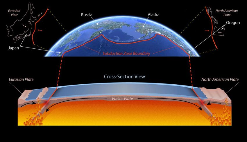
The Oregon Resilience Plan – Cascadia: Oregon’s Greatest Natural Threat – February 2013                                5

                                                                    Figure 1.2: This photo (Source: Brian Atwater, USGS)
                                                                    shows a riverbank from the Salmon River estuary
                                                                    where Native American firepots were found in a forest
                                                                    soil that subsided in the 1700 AD earthquake and was
                                                                    buried by tsunami sand and tidal mud.

Geologists have assembled a ten thousand year record of past Cascadia earthquakes (see Figure 1.3) by
studying sediments in coastal marshes and on the ocean floor. This record shows that past earthquakes
have occurred at highly variable intervals and can range widely in size and in which parts of the Pacific
Northwest they affect. About half of the past earthquakes have been very large (estimated magnitude
8.3 to 8.6) and centered on the southern Oregon coast, while the other half have been great (estimated
magnitude 8.7 to 9.3) and extending from northern California to British Columbia. The most recent
event occurred on January 26, 1700 AD, and was a great earthquake with a magnitude of 9.0. The time
interval between previous earthquakes has varied from a few decades to many centuries, but most of
the past intervals have been shorter than the 313 years since the last event. It is simply not scientifically
feasible to predict, or even estimate, when the next Cascadia earthquake will occur, but the calculated
odds that a Cascadia earthquake will occur in the next 50 years range from 7-15 percent for a great
earthquake affecting the entire Pacific Northwest to about 37 percent for a very large earthquake
affecting southern Oregon and northern California. The likelihood of a M 9 Cascadia earthquake during
our lifetimes and the consequences of such an earthquake are both so great that it is prudent to
consider this type of earthquake when designing new structures or retrofit of existing structures,
evaluating the seismic safety of existing structures, or planning emergency response and preparedness.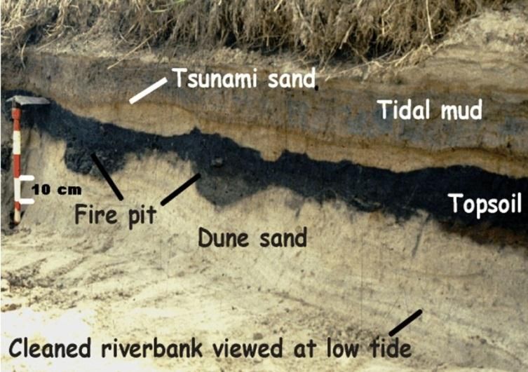
The Oregon Resilience Plan – Cascadia: Oregon’s Greatest Natural Threat – February 2013 6
Figure 1.3: This timeline compares the 10,000-year-long history of Cascadia earthquakes to events in human history.
Resilience Plan Earthquake Scenario
For the purpose of this resilience planning effort, we chose to look at the effects of a great earthquake
of magnitude 9.0, because it is a very real possibility that would affect all of Oregon and is directly
comparable to the 2011 Tohoku earthquake, the effects of which are all too well known. Using the latest
models from the United States Geological Survey (USGS), we simulated the strong shaking that is likely
to occur during the region’s next magnitude 9.0 event. The simulated shaking map was then used to
estimate the amount of ground failure due to liquefaction and landsliding that would result from such
an earthquake. For the tsunami, we used a model of the inundation from a magnitude 9.0 event. This
model, which was produced by the Oregon Department of Geology and Mineral Industries (DOGAMI),
was applied to maps of the coast to show which areas and facilities would be inundated. The tsunami
models also provided estimates of the permanent coastal subsidence that would accompany the
earthquake and tsunami. These maps of simulated earthquake effects were used to evaluate the likely
performance of Oregon’s critical buildings and infrastructure.
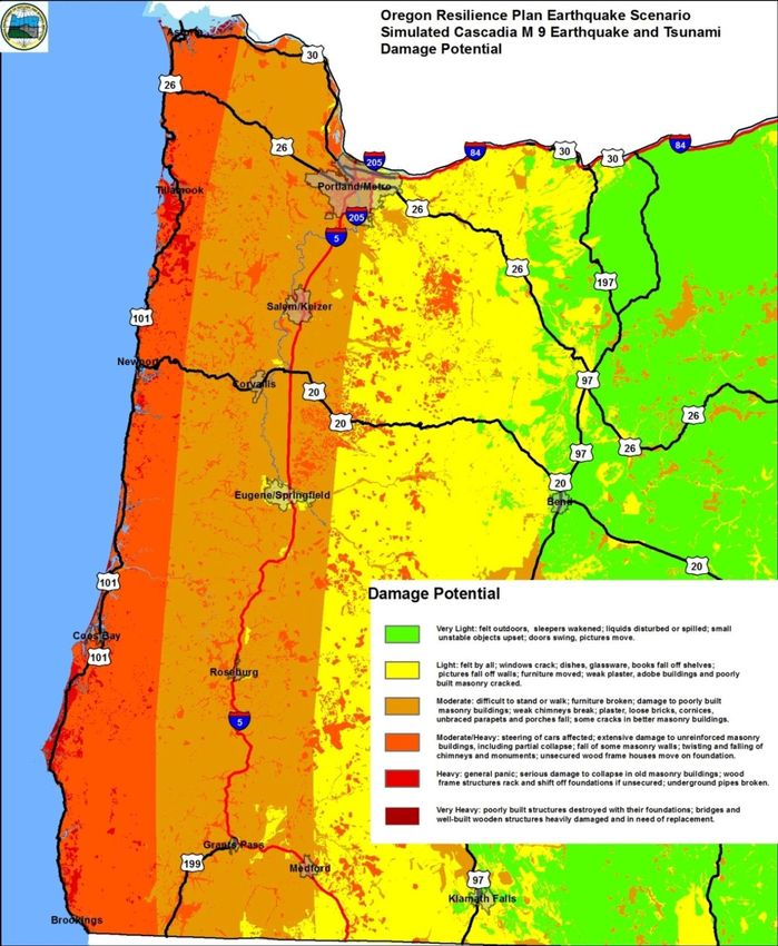
The simulation shows that Oregon would experience shaking very similar to the shaking that northern
Japan endured in 2011. As indicated in Figure 1.4, areas along Oregon’s coast would experience severe
to violent shaking, while cities along the I-5 corridor would experience strong or very strong shaking.
East of the Cascades, shaking would be light to moderate. In all areas, the strong shaking would last
from two to four minutes.
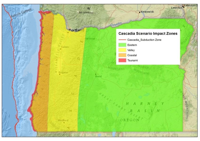
This expected pattern of damage led OSSPAC to evaluate the state in four distinct zones (see Figure 1.5):
The Tsunami Zone, where severe shaking and tsunami inundation would cause near total
damage, and threaten the lives of thousands of residents.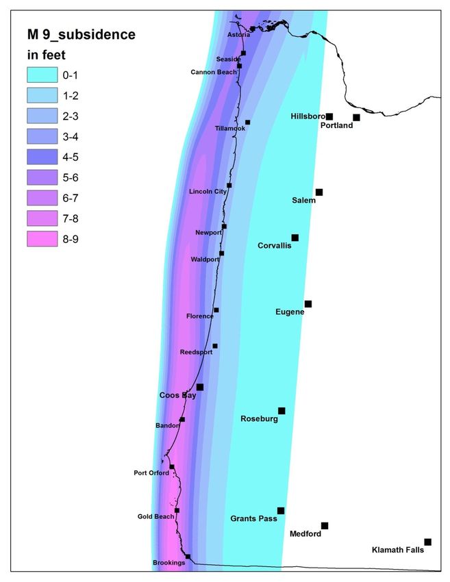
The Oregon Resilience Plan – Cascadia: Oregon’s Greatest Natural Threat – February 2013 7
The Coastal Zone, where severe shaking and damage to transportation systems would severely
disrupt and isolate communities and where the major challenge after the earthquake would be
to keep the population sheltered, fed and healthy.
The Valley Zone, where widespread moderate damage would severely disrupt daily life and
commerce and where restoring services to business and residents would be the main priority.
The Eastern zone where light damage would allow rapid restoration of services and functions,
and where communities would become critical hubs for the movement of response recovery
and restoration personnel and materials for the rest of the state.
The results of the ground failure simulation (see Figure 1.6) suggest that large areas of western Oregon
would be severely affected. Strong shaking causes ground failure in two ways. Along rivers, lakes, and
the coast, where there are deposits of loose water-saturated sand, shaking causes the sand to liquefy,
and the weakened soil readily settles or spreads. On steep slopes with weak soil and rock, or in areas of
existing landslides, the shaking can cause new or renewed landslide movement, with very damaging
results. Ground failure can cause severe damage to buildings and is particularly damaging to lifelines,
which by their nature must often cross wide areas of affected ground.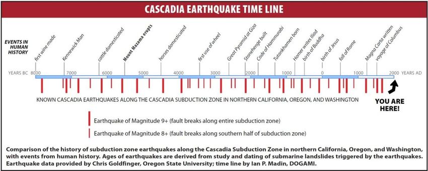
The Oregon Resilience Plan – Cascadia: Oregon’s Greatest Natural Threat – February 2013             8

                           Figure 1.4: Simulated shaking for the magnitude 9.0 Cascadia scenario.
The Oregon Resilience Plan – Cascadia: Oregon’s Greatest Natural Threat – February 2013 9
Figure 1.5: Impact zones for the magnitude 9.0 Cascadia earthquake scenario. Damage will be extreme in the Tsunami zone, heavy in the
Coastal zone, moderate in the Valley zone, and light in the Eastern zone.The Oregon Resilience Plan – Cascadia: Oregon’s Greatest Natural Threat – February 2013 10
Figure 1.6: Ground failure and movement for the magnitude 9.0 Cascadia earthquake scenario. Colored areas could experience more than one
foot of ground movement due to earthquake-induced landslides in steep areas and liquefaction failure in lowlands. Both forms of ground failure
can cause severe damage.
The amount of tsunami inundation that would be experienced along the coast due to the scenario
magnitude 9.0 earthquake is quite variable and depends on local topography. Large parts of many low-
lying communities, such as Warrenton, Seaside, Rockaway Beach, and Neskowin (see Figure 1.7), will be
inundated.The Oregon Resilience Plan – Cascadia: Oregon’s Greatest Natural Threat – February 2013 11
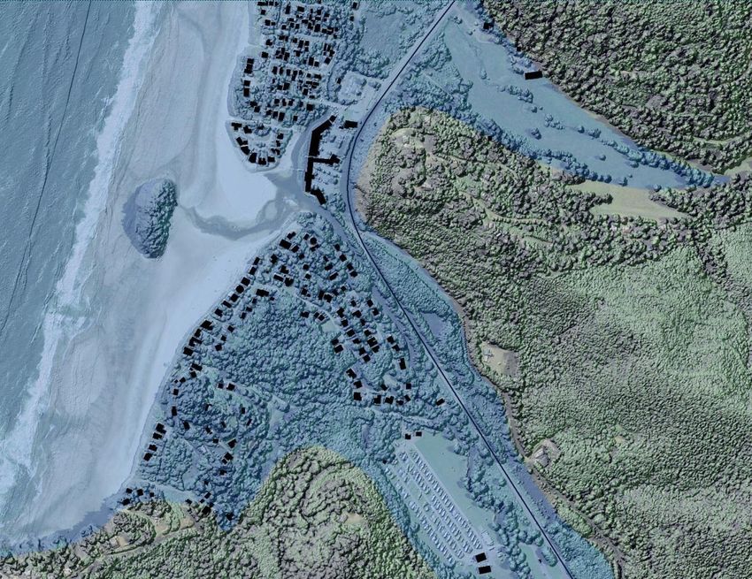
NESKOWIN
Figure 1.7: Estimated inundation of Neskowin due to the tsunami from the scenario magnitude 9.0 Cascadia earthquake. This tsunami map is
based on the SB 379 regulatory inundation line.
The same large scale bending of the tectonic plates that causes the tsunami will also cause immediate
and permanent subsidence in many parts of the coast. As indicated in Figure 1.8, the amount that the
land will drop varies from place to place, with as much as 5 to 6 feet possible near Astoria, and even
more possible at Brookings.The Oregon Resilience Plan – Cascadia: Oregon’s Greatest Natural Threat – February 2013 12
Figure 1.8: Estimated permanent land subsidence from the scenario magnitude 9.0 earthquake for the Oregon Coast. Subsidence would occur
during the earthquake.The Oregon Resilience Plan – Cascadia: Oregon’s Greatest Natural Threat – February 2013 13 Oregon’s Infrastructure and Risk The estimated impacts of a Cascadia subduction earthquake in Oregon are catastrophic. This is partly due to the sheer size and power of a magnitude 9.0 earthquake, but it is also the result of the inherent vulnerability of our buildings and lifelines. In 1974, Oregon adopted a statewide building code that mandated some seismic resistance for new construction. Prior to that date, the majority of buildings in Oregon had been designed without regard to earthquake forces. In 1993, Oregon’s building codes were changed to require designs that would accommodate shaking from a Cascadia subduction zone earthquake, almost doubling the earthquake forces used in earlier codes. This means that the majority of buildings in Oregon have not been designed to resist the shaking from a magnitude 9.0 Cascadia earthquake. This widespread vulnerability of Oregon’s buildings is grimly illustrated in the Statewide Seismic Needs Assessment completed by the Oregon Department of Geology and Mineral Industries (DOGAMI) in 2007. This study surveyed public schools and public safety buildings (police and fire stations, hospitals, and emergency operation centers) in Oregon and assessed their potential for collapse in a major earthquake. Almost half of the 2,193 public school buildings examined had a high or very high potential for collapse, as did almost a quarter of the public safety buildings. Of the 2,567 highway bridges in the Oregon Department of Transportation (ODOT) system, 982 were built without seismic considerations, and of the rest, only 409 were designed specifically with consideration of Cascadia subduction zone earthquakes. The list goes on: old, brittle iron water pipes in the Portland water system, century-old bridges over the Willamette River, and highways and power transmission lines that traverse landslide-prone terrain. The core of our vulnerability to a Cascadia earthquake is not the earthquake alone, but the inadequacy of our built environment. The experience of the Tohoku earthquake shows that few structures are likely to survive in the tsunami inundation zone. In Oregon, the USGS estimates that almost 1,900 businesses employing nearly 15,000 people are located in the scenario inundation zone. The inundation zone also contains almost 10,500 housing units with a total population of just over 22,000. This exposure to the extreme hazard posed by the tsunami is unavoidable. Another major factor that amplifies the effects of a Cascadia earthquake is the interdependency of our lifeline systems, coupled with the wide geographic spread of a Cascadia disaster. Unlike a severe storm, a Cascadia subduction earthquake would simultaneously damage power, natural gas, and petroleum lines, roads and bridges, water and sewer systems, critical buildings, and communications over large parts of three states (i.e., California, Oregon and Washington). Restoration of communication service would require that electric power be restored, which would require that roads and bridges be repaired, which in turn would require that the petroleum delivery and distribution system be repaired. These interdependencies between lifeline systems would be made even more difficult by the broad geographic extent of the damage. The nearest undamaged urban areas from which assistance could be organized would be Spokane, Washington, Boise, Idaho, and Redding, California. Virtually all of the resources required for the recovery of lifeline systems would have to come from outside the affected states.
The Oregon Resilience Plan – Cascadia: Oregon’s Greatest Natural Threat – February 2013 14
Estimated Impacts
The scenario Cascadia earthquake would be an unprecedented catastrophe for Oregon and for the
United States. It would impact every aspect of life for all Oregonians and for the residents of northern
California, Washington, and British Columbia. The effects of a Cascadia subduction earthquake will be
greatest on the coast, which is right next to the subduction zone fault, and will diminish as one goes
inland. This, in combination with Oregon’s mountainous geography, divides the state into four impact
zones: within the tsunami zone, damage will be nearly complete. In the coastal zone, shaking will be
severe, liquefaction and landsliding will be widespread and severe, and damage will be severe. In the
valley zone, shaking will be strong, liquefaction and landsliding will be common but less severe, and
moderate damage will be widespread. In the eastern zone, shaking will be mild, landslides and
liquefaction sporadic, and damage generally light.
The impacts of a great subduction earthquake on Oregon are impossible to predict accurately, but
several studies have estimated damage and casualties, and those estimates give a sense for how far-
reaching a disaster the next great earthquake will be. Estimated consequences include:
Earthquake deaths ranging from 650 to 5,000, with another 600 to 5,000 deaths due to the
tsunami.
24,000 buildings completely destroyed, and another 85,000 with extensive damage requiring
months to years of repair.
Approximately $32 billion in economic losses.
27,600 displaced households.
Almost 10 million tons of debris (1 million dump truck loads).
These high levels of damage and loss reflect both the great size of the earthquake and the fact that
many buildings, roads, bridges, and utility networks were designed before Oregon’s building codes and
practices recognized any significant earthquake threats, and most were designed before codes began to
take great subduction earthquakes into account. Lifeline systems, such as highways and pipelines, are
particularly vulnerable to ground failure, which will be widespread in the next great earthquake. As a
result, the vulnerability analyses done for this plan are grim. For example, if the earthquake were to
happen tomorrow, the estimated time to restore function would be:
One to three years to restore drinking water and sewer service in the coastal zone.
One month to one year to restore water and sewer in the valley zone.
Six to twelve months to restore partial function of the top-priority highways in the valley zone.
Two to four months to restore police and fire stations in the valley zone.
Eighteen months to restore healthcare facilities in the valley zone, three years or more in the
coastal zone.The Oregon Resilience Plan – Cascadia: Oregon’s Greatest Natural Threat – February 2013 15
One to three months to restore electricity service in the valley zone.
Three to six months to restore electricity service in the coastal zone.
These estimates of the time it will take to restore the functions necessary to maintain our population
and economy are sobering, particularly when coupled with the likelihood that businesses will start to
leave the state if services are not restored within one month. If we pursue a policy of “business as
usual,” our future after the next Cascadia earthquake will include decades-worth of declining economy
and population. We can only avoid this future and achieve resilience by starting now on a sustained
program to reduce our vulnerability and decrease our recovery time before the next earthquake
inevitably occurs.
Recommendations
The Cascadia Scenario workgroup prepared a description of the likely effects of a magnitude 9
subduction earthquake for the other workgroups to use in their evaluations. The scenario used the best
currently available data, and well-established methods, but still provides an estimate that has a lot of
uncertainty and little detail. For an improved understanding of the threat posed by Cascadia
earthquakes, we recommend that the state:
► Support Oregon universities and state agencies to carry out research into the effects of future
Cascadia subduction earthquakes and tsunamis on Oregon's landscape, population, buildings
and lifelines;
► Support Oregon universities and state agencies in preparing more detailed and accurate
estimates of damage and loss in Oregon from future Cascadia subduction earthquakes and
tsunamis; and
► Provide ready access to the best available Cascadia earthquake information for emergency
responders and planners, architects and engineers, and the general public.
► In order to ensure that design of future structures, retrofit of existing structures, seismic
vulnerability evaluations and preparedness planning will provide adequate resilience, we also
recommend that all of these efforts use, as a minimum, the ground motion parameters
provided by the most current version of the International Building Code, which reflect the most
current USGS seismic hazard maps.The Oregon Resilience Plan – Cascadia: Oregon’s Greatest Natural Threat – February 2013 16
Reference
1. DOGAMI (2007), Statewide Seismic Needs Assessment Using Rapid Visual Screening (RVS). For
detailed information, see http://www.oregongeology.com/sub/projects/rvs/default.htm#overview
2. Oregon Department of Transportation (2009), Seismic Vulnerability of Oregon State Highway
Bridges: Mitigation Strategies to Reduce Major Mobility Risks. For detailed information, see
ftp://ftp.odot.state.or.us/Bridge/bridge_website_chittirat/2009_Seismic_Vulnerability_final.pdf.
3. SPUR (2009). The Resilient City: Defining What San Francisco Needs from Seismic Mitigation
Policies. For detailed information, see http://www.spur.org/initiative/resilient-city
4. Washington Seismic Safety Committee (2012). Resilient Washington State: A Framework for
Minimizing Loss and Improving Statewide Recovery after an Earthquake. November. See
http://www.emd.wa.gov/about/SeismicSafetyCommittee.shtmlYou can also read