CD 622 Managing geotechnical risk
←
→
Page content transcription
If your browser does not render page correctly, please read the page content below
Design Manual for Roads and Bridges

Geotechnics
Design

CD 622
Managing geotechnical risk
(formerly HD 22/08, BD 10/97, HA 120/08)

Revision 1

Summary
This document defines the technical approval and certification procedures to be used to ensure
that the risks associated with geotechnical activities are appropriately managed.

Application by Overseeing Organisations
Any specific requirements for Overseeing Organisations alternative or supplementary to those given in this document
are given in National Application Annexes to this document.

Feedback and Enquiries
Users of this document are encouraged to raise any enquiries and/or provide feedback on the content and usage
of this document to the dedicated Highways England team. The email address for all enquiries and feedback is:
Standards_Enquiries@highwaysengland.co.uk

This is a controlled document.
CD 622 Revision 1                                                                                                                                                        Contents

Contents
Release notes                                                                                                                                                                     4

Foreword                                                                                                                                                                          5
   Publishing information . . . . . . . . . . . . . . . . . . . . . . . . . . . . . . . . . . . . . . . . . . . . . . . .                                                         5
   Relationship with other publications . . . . . . . . . . . . . . . . . . . . . . . . . . . . . . . . . . . . . . . .                                                           5
   Contractual and legal considerations . . . . . . . . . . . . . . . . . . . . . . . . . . . . . . . . . . . . . . . .                                                           5

Introduction                                                                                                                                                                      6
    Background . . . . . . . . . . . . . . . . . . . . . . . . . . . . . . . . . . . . . . . . . . . . . . . . . . . . . .                                                        6
    Assumptions made in the preparation of this document . . . . . . . . . . . . . . . . . . . . . . . . . . . . .                                                                6

Abbreviations                                                                                                                                                                     7

Terms and definitions                                                                                                                                                             8

1. Scope                                                                                                                                                                         10
   Aspects covered . . . . . . . . . . . . . . . . . . . . . . . . . . . . . . . . . . . . . . . . . . . . . . . . . . .                                                         10
   Implementation . . . . . . . . . . . . . . . . . . . . . . . . . . . . . . . . . . . . . . . . . . . . . . . . . . . .                                                        10
   Use of GG 101 . . . . . . . . . . . . . . . . . . . . . . . . . . . . . . . . . . . . . . . . . . . . . . . . . . . .                                                         10

2. General requirements                                                                                                                                                          11

3. Geotechnical risk management and the Geotechnical Risk Register                                                                                                               13

4. Geotechnical reporting requirements                                                                                                                                           14

5. Geotechnical category                                                                                                                                                         16

6. Geotechnical certification                                                                                                                                                    17

7. Specific risks and requirements with trenchless construction                                                                                                                  18

8. Specific risks and requirements in areas of underground void risk and past mining                                                                                             20

9. Normative references                                                                                                                                                          21

10. Informative references                                                                                                                                                       22

Appendix A. Geotechnical certificate                                                                                                                                             23

Appendix B. Geotechnical Risk Register                                                                                                                                           25

Appendix C. Recommended content for Statement of Intent                                                                                                                          28
  C1 Project . . . . . . . . . . . . . . . . . . . . . . . . . . . . .   .   .   .   .   .   .   .   .   .   .   .   .   .   .   .   .   .   .   .   .   .   .   .   .   .   .   28
  C2 Objectives . . . . . . . . . . . . . . . . . . . . . . . . . . .    .   .   .   .   .   .   .   .   .   .   .   .   .   .   .   .   .   .   .   .   .   .   .   .   .   .   28
  C3 Existing information . . . . . . . . . . . . . . . . . . . . .      .   .   .   .   .   .   .   .   .   .   .   .   .   .   .   .   .   .   .   .   .   .   .   .   .   .   28
  C4 Geotechnical risk . . . . . . . . . . . . . . . . . . . . . . .     .   .   .   .   .   .   .   .   .   .   .   .   .   .   .   .   .   .   .   .   .   .   .   .   .   .   28
  C5 Proposed studies and investigations . . . . . . . . . . . .         .   .   .   .   .   .   .   .   .   .   .   .   .   .   .   .   .   .   .   .   .   .   .   .   .   .   28
  C6 Specialist consultation . . . . . . . . . . . . . . . . . . . .     .   .   .   .   .   .   .   .   .   .   .   .   .   .   .   .   .   .   .   .   .   .   .   .   .   .   28
  C7 Programme . . . . . . . . . . . . . . . . . . . . . . . . . .       .   .   .   .   .   .   .   .   .   .   .   .   .   .   .   .   .   .   .   .   .   .   .   .   .   .   28

Appendix D. Recommended content for preliminary sources study report                                                                                                             29
  D1 Title sheet(s) . . . . . . . . . . . . . . . . . . . . . . . . . . . . . . . . . . . . . . . . . . . . . .                                              .   .   .   .   .   29
  D2 Introduction . . . . . . . . . . . . . . . . . . . . . . . . . . . . . . . . . . . . . . . . . . . . . . .                                              .   .   .   .   .   29
  D3 Sources of information, desk study, site reconnaissance, site description and review of findings                                                        .   .   .   .   .   29
  D4 Site reconnaissance . . . . . . . . . . . . . . . . . . . . . . . . . . . . . . . . . . . . . . . . . .                                                 .   .   .   .   .   29
  D5 Ground conditions . . . . . . . . . . . . . . . . . . . . . . . . . . . . . . . . . . . . . . . . . . .                                                 .   .   .   .   .   29
  D6 Preliminary engineering assessment . . . . . . . . . . . . . . . . . . . . . . . . . . . . . . . . .                                                    .   .   .   .   .   30

                                                               1
CD 622 Revision 1 Contents
D7 Comparison of project options and risks . . . . . . . . . . . . . . . . . . . . . . . . . . . . . . . . . . . . 30
D8 Drawings and photographs . . . . . . . . . . . . . . . . . . . . . . . . . . . . . . . . . . . . . . . . . . . 30
Appendix E. Recommended content for Ground Investigation Scope Report (GISR) 31
E1 Objectives . . . . . . . . . . . . . . . . . . . . . . . . . . . . . . . . . . . . . . . . . . . . . . . . . . . . . 31
E2 Proposed investigation . . . . . . . . . . . . . . . . . . . . . . . . . . . . . . . . . . . . . . . . . . . . . . 31
E3 Site and working restrictions . . . . . . . . . . . . . . . . . . . . . . . . . . . . . . . . . . . . . . . . . . . 31
E4 Specialist consultation . . . . . . . . . . . . . . . . . . . . . . . . . . . . . . . . . . . . . . . . . . . . . . 31
E5 Programme . . . . . . . . . . . . . . . . . . . . . . . . . . . . . . . . . . . . . . . . . . . . . . . . . . . . 31
E6 Reporting . . . . . . . . . . . . . . . . . . . . . . . . . . . . . . . . . . . . . . . . . . . . . . . . . . . . . 31
Appendix F. Recommended content for Ground Investigation Report (GIR) 32
F1 Title sheet . . . . . . . . . . . . . . . . . . . . . . . . . . . . . . . . . . . . . . . . . . . . . . . . . . . . . 32
F2 Introduction . . . . . . . . . . . . . . . . . . . . . . . . . . . . . . . . . . . . . . . . . . . . . . . . . . . . 32
F3 Existing information . . . . . . . . . . . . . . . . . . . . . . . . . . . . . . . . . . . . . . . . . . . . . . . 32
F4 Field and laboratory studies . . . . . . . . . . . . . . . . . . . . . . . . . . . . . . . . . . . . . . . . . . . 32
F5 Ground summary . . . . . . . . . . . . . . . . . . . . . . . . . . . . . . . . . . . . . . . . . . . . . . . . . 32
F6 Geotechnical Risk Register . . . . . . . . . . . . . . . . . . . . . . . . . . . . . . . . . . . . . . . . . . . 32
F7 Engineering assessment . . . . . . . . . . . . . . . . . . . . . . . . . . . . . . . . . . . . . . . . . . . . . 32
F8 References . . . . . . . . . . . . . . . . . . . . . . . . . . . . . . . . . . . . . . . . . . . . . . . . . . . . 33
Appendix G. Recommended content for Geotechnical Design Report 34
G1 Cuttings . . . . . . . . . . . . . . . . . . . . . . . . . . . . . . . . . . . . . . . . . . . . . . . . . . . . . . 34
G2 Embankments . . . . . . . . . . . . . . . . . . . . . . . . . . . . . . . . . . . . . . . . . . . . . . . . . . 34
G3 Highway structures . . . . . . . . . . . . . . . . . . . . . . . . . . . . . . . . . . . . . . . . . . . . . . . . 34
G4 SGM . . . . . . . . . . . . . . . . . . . . . . . . . . . . . . . . . . . . . . . . . . . . . . . . . . . . . . . . 34
G5 Drainage . . . . . . . . . . . . . . . . . . . . . . . . . . . . . . . . . . . . . . . . . . . . . . . . . . . . . 34
G6 Pavement design, subgrade design (including the need for in-situ treatment, etc.) and capping . . . . . 34
G7 Contamination and ground gas risks . . . . . . . . . . . . . . . . . . . . . . . . . . . . . . . . . . . . . . 35
G8 Ground treatment (including void stabilisation) . . . . . . . . . . . . . . . . . . . . . . . . . . . . . . . . 35
G9 Geotechnical Risk Register . . . . . . . . . . . . . . . . . . . . . . . . . . . . . . . . . . . . . . . . . . . 35
G10 Specification appendices . . . . . . . . . . . . . . . . . . . . . . . . . . . . . . . . . . . . . . . . . . . . 35
G11 Instrumentation and monitoring . . . . . . . . . . . . . . . . . . . . . . . . . . . . . . . . . . . . . . . . 35
G12 Pile testing requirements . . . . . . . . . . . . . . . . . . . . . . . . . . . . . . . . . . . . . . . . . . . . 35
G13 Annex 1 . . . . . . . . . . . . . . . . . . . . . . . . . . . . . . . . . . . . . . . . . . . . . . . . . . . . . 35
G14 Annex 2 . . . . . . . . . . . . . . . . . . . . . . . . . . . . . . . . . . . . . . . . . . . . . . . . . . . . . 35
Appendix H. Recommended content for Special Geotechnical Measures Form 36
H1 Format . . . . . . . . . . . . . . . . . . . . . . . . . . . . . . . . . . . . . . . . . . . . . . . . . . . . . . 36
H2 SGM . . . . . . . . . . . . . . . . . . . . . . . . . . . . . . . . . . . . . . . . . . . . . . . . . . . . . . . . 36
H3 Outline of existing ground and groundwater conditions (to be referenced to the relevant sections of the
GIR) . . . . . . . . . . . . . . . . . . . . . . . . . . . . . . . . . . . . . . . . . . . . . . . . . . . . . . . 36
H4 Proposed SGM . . . . . . . . . . . . . . . . . . . . . . . . . . . . . . . . . . . . . . . . . . . . . . . . . . 36
H5 Design methods . . . . . . . . . . . . . . . . . . . . . . . . . . . . . . . . . . . . . . . . . . . . . . . . . 36
H6 Checking . . . . . . . . . . . . . . . . . . . . . . . . . . . . . . . . . . . . . . . . . . . . . . . . . . . . . 37
H7 Signature format for SGMF: . . . . . . . . . . . . . . . . . . . . . . . . . . . . . . . . . . . . . . . . . . . 37
Appendix I. Recommended content for Geotechnical Feedback Report (GFR) 39
I1 Title sheet . . . . . . . . . . . . . . . . . . . . . . . . . . . . . . . . . . . . . . . . . . . . . . . . . . . . . 39
I2 Introduction . . . . . . . . . . . . . . . . . . . . . . . . . . . . . . . . . . . . . . . . . . . . . . . . . . . . 39
I3 Earthworks . . . . . . . . . . . . . . . . . . . . . . . . . . . . . . . . . . . . . . . . . . . . . . . . . . . . . 39
I4 Cuttings . . . . . . . . . . . . . . . . . . . . . . . . . . . . . . . . . . . . . . . . . . . . . . . . . . . . . . 39
I5 Embankments . . . . . . . . . . . . . . . . . . . . . . . . . . . . . . . . . . . . . . . . . . . . . . . . . . . 39
I6 Subgrade/capping/pavement . . . . . . . . . . . . . . . . . . . . . . . . . . . . . . . . . . . . . . . . . . . 39
I7 Drainage . . . . . . . . . . . . . . . . . . . . . . . . . . . . . . . . . . . . . . . . . . . . . . . . . . . . . . 40
I8 Imported materials . . . . . . . . . . . . . . . . . . . . . . . . . . . . . . . . . . . . . . . . . . . . . . . . 40
I9 SGM . . . . . . . . . . . . . . . . . . . . . . . . . . . . . . . . . . . . . . . . . . . . . . . . . . . . . . . . 40
2CD 622 Revision 1 Contents
I10 Structure foundations . . . . . . . . . . . . . . . . . . . . . . . . . . . . . . . . . . . . . . . . . . . . . . 40
I11 Materials testing . . . . . . . . . . . . . . . . . . . . . . . . . . . . . . . . . . . . . . . . . . . . . . . . . 40
I12 Instrumentation . . . . . . . . . . . . . . . . . . . . . . . . . . . . . . . . . . . . . . . . . . . . . . . . . . 40
I13 Summary of issues experienced and design changes . . . . . . . . . . . . . . . . . . . . . . . . . . . . 41
I14 Geotechnical Risk Register . . . . . . . . . . . . . . . . . . . . . . . . . . . . . . . . . . . . . . . . . . . 41
I15 Residual health and safety risks . . . . . . . . . . . . . . . . . . . . . . . . . . . . . . . . . . . . . . . . 41
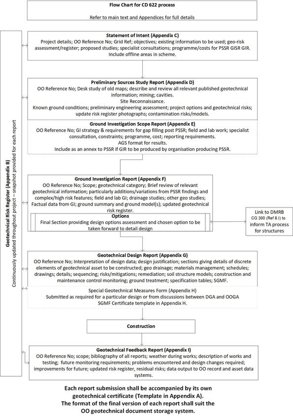
Appendix J. Flow chart of CD 622 process 42
3CD 622 Revision 1 Release notes
Release notes
Version Date Details of amendments
1 Mar 2020 Revision 1 (March 2020) Update to references and revised Scotland National
Application Annex. Revision 0 (August 2019) CD 622 replaces HD 22/08, BD
10/97 and HA 120/08. The philosophy of the original document remains the
same but the full document has been re-written to make it compliant with the
new Highways England drafting rules.
4CD 622 Revision 1 Foreword
Foreword
Publishing information
This document is published by Highways England.
This document supersedes HD 22/08, BD 10/97 and HA 120/08, which are withdrawn.
Relationship with other publications
This document contains references to other documents of the DMRB, British Standards, Eurocodes,
Transport Scotland, Welsh Government and CIRIA documents.
Contractual and legal considerations
This document does not purport to include all the necessary provisions of a contract. Users are
responsible for applying all appropriate documents applicable to their contract.
5CD 622 Revision 1 Introduction
Introduction
Background
An essential part of the project lifecycle is the identification and management of risks, and all parties
have a role in ensuring that risks are identified and avoided or reduced to tolerable levels. Ground
conditions are often uncertain and present risks which have to be managed proactively. Cost overrun
was the main risk that the forerunner of this DMRB document set out to overcome in 1992. However,
ground related risks continue to affect and influence many aspects of highway construction, operation
and management. A revised DMRB document issued in 2002 introduced formal geotechnical risk
management and followed the guidance given in BS EN 1997 [Ref 2.N]. The 2008 revision further
simplified and improved the process with the reporting being aligned to reflect the requirements of BS
EN 1997 [Ref 2.N]. This version has maintained the essential requirements of the 2008 document but
has condensed the text, added the opportunity to adopt a more flexible report format (by agreement for
each project), renamed the Annex A as the ground investigation scope report and renamed the
strengthened earthwork appraisal form as the special geotechnical measures form.
In Scotland, for road projects promoted by the Trunk Road Authority, the principles of this document are
to be adopted, but differing organisational structures mean that separate certification and checking
requirements are in place. See the Scotland National Application Annex for further details.
Assumptions made in the preparation of this document
The assumptions made in GG 101 [Ref 6.N] apply to this document.
6CD 622 Revision 1 Abbreviations
Abbreviations
Abbreviations
Abbreviation Definition
AGS Association of Geotechnical and Geoenvironmental Specialists
CV Curriculum vitae
DGA Designer's Geotechnical Advisor
EqIA Equality Impact Assessment
GDR Geotechnical Design Report
GIR Ground Investigation Report
GISR Ground Investigation Scope Report
GFR Geotechnical Feedback Report
ICC Independent Checking Consultant
OO Overseeing Organisation
Unique report number for use in the OO geotechnical asset management
OO Reference No.
system
OOGA Overseeing Organisation's Geotechnical Advisor
Preliminary Sources Study Report (including the desk study and site
PSSR
reconnaissance described in BS 5930 [Ref 1.N])
RoGEP Register of Ground Engineering Professionals
SGM Special geotechnical measures
SGMF Special Geotechnical Measures Form
SHW Specification for Highway Works (Highways England)
SoI Statement of Intent (report)
7CD 622 Revision 1 Terms and definitions
Terms and definitions
Terms
Term Definition
A standard data file format defined by the Association of
AGS file
Geotechnical and Geoenvironmental Specialists.
Designer The organisation employed to carry out the design of the works.
Engineering works that have been constructed using soil and/or
Earthworks
rock involving change in elevation of the ground level.
A report that presents the findings of physical ground investigation
Factual report
work and associated laboratory testing.
To include the design, construction and maintenance of:
1) earthworks;
2) special geotechnical measures;
3) ground investigations, both intrusive and non-intrusive;
4) excavation/assessment below carriageway construction level;
5) earth retaining structures;
Geotechnical activity 6) structural foundations and excavations;
7) tunnelling;
8) trenchless crossings;
9) excavations for services on/or adjacent to earthworks and/or
natural slopes, including drains, electricity and communications
cables (includes OO and third party services);
10) ground treatment.
A Chartered Engineering Geologist or Geotechnical Engineer, with
Geotechnical Advisor
experience as defined in clause 2.12.
The man-made or natural earthworks and geotechnical structures
Geotechnical asset below the road pavement layers, highways structures and the
adjacent land within the OO boundary.
A document to certify the reports required by the geotechnical
Geotechnical Certificate
risk management process.
The risk to the OO's asset or the project, the public, environment,
Geotechnical risk construction and operational activities created by the site ground
conditions.
The essential tool for documenting risks and actions to manage
Geotechnical Risk Register each risk and used to drive the geotechnical risk management
process.
An object, feature, event or activity that has the potential to have
Hazard
adverse effects or undesirable consequences.
Intrusive works involve breaking the ground surface, for example
Intrusive and non-intrusive
boreholes, excavations.Non-intrusive works involve geophysical
works
methods to obtain data without breaking the ground surface.
8CD 622 Revision 1 Terms and definitions
Terms (continued)
Term Definition
A geotechnical consultant employed by the Overseeing
Independent checking
Organisation to carry out an independent check of aspects of the
consultant
geotechnical design.
Highways England or the highways or roads authorities or the
Overseeing Organisation devolved administrations of Scotland, Wales and Northern Ireland,
and their successors.
A measure of the likelihood of a hazard occurring and the
Risk
resulting possible consequences.
Techniques that:
1) enable a soil or rock to permanently stand at an angle greater
than achievable by simple earthworks (for example the
inclusion of tensile reinforcement, soil nailing, chemical
additives or external support such as gabions);
Special geotechnical measures
2) mitigate a pre-existing geotechnical hazard;
3) remediate a post-construction defect.
4) the term allows the identification of such areas in asset data
systems.
Any person, organisation or other legal entity that is not employed
Third party
directly or indirectly by the Overseeing Organisation.
9CD 622 Revision 1 1. Scope
1. Scope
Aspects covered
1.1 This DMRB document shall be used to define the procedures, documentation and certification for all
works undertaken on Overseeing Organisation (OO) highways projects and third party works that
impact the OO's geotechnical asset.
NOTE 1 In Scotland, for road projects promoted by the Trunk Road Authority, differing organisational structures
mean that separate certification and checking requirements are currently being retained. Please refer
to the Scotland National Application Annex and Transport Scotland.
NOTE 2 In Wales the certification and checking requirements are augmented by the advice document
'Managing geotechnical risk. Implementation guidance - Wales' MGRG (W) [Ref 3.I].
Implementation
1.2 This document shall be implemented forthwith on all schemes involving geotechnical activities on the
OO's motorway and all-purpose trunk roads according to the implementation requirements of GG 101
[Ref 6.N].
Use of GG 101
1.3 The requirements contained in GG 101 [Ref 6.N] shall be followed in respect of activities covered by
this document.
10CD 622 Revision 1 2. General requirements
2. General requirements
2.1 This DMRB document shall be used to provide a clear and consistent record of the management of
geotechnical risks to the highways asset at all stages in a project (options, development, construction
and removal).
2.2 The record shall be passed forward for operation and ultimately removal of the asset.
2.3 Reporting and certification shall be provided at each stage of the project as required by the OOGA to
provide an auditable record.
2.4 If the method of procurement or designer is changed during a scheme then any concerns about the
adequacy of the geotechnical information previously produced and certified shall be raised with the OO
at changeover.
2.5 This DMRB document shall be applied to all geotechnical works that can impact on the OO's asset,
including the OO's and third party works.
2.6 Any areas outside the current OO's asset that fall within the scope or impact of the project shall also be
included in geotechnical studies.
2.7 Two key personnel shall be appointed to manage the geotechnical risk, namely the Designer's
Geotechnical Advisor (DGA) and the Overseeing Organisation's Geotechnical Advisor (OOGA).
2.8 Where geotechnical submissions are produced within an OO the DGA shall be separate to the OOGA.
2.9 The curriculum vitae (CV) for the individual to be appointed as DGA shall demonstrate the qualifications
and experience to meet the requirements in Cl. 2.12.
2.10 The CV of the DGA shall be subject to approval by the OOGA.
2.11 The DGA and OOGA shall liaise from the start of and throughout the project.
2.12 A Geotechnical Advisor shall be a Chartered Member of the ICE, IoM3 or GSL, or equivalent, and will
have at least ten years (or a relevant Masters degree and eight years) relevant post-chartership
experience in ground engineering and infrastructure works.
NOTE This requirement in Clause 2.12 exceeds that of general eligibility for entry onto the Register of Ground
Engineering Professionals (RoGEP) at Adviser level.
2.13 The focal point for the planning, procurement, interpretation and implementation of all geotechnical
aspects of the project shall be the DGA acting as the designer's lead professional.
2.14 Where different organisations are sub-contracted to provide specialist input, the management
responsibility of geotechnical risks associated with their input shall remain with the DGA.
2.15 The reports required by this document shall identify all of the geotechnical risks associated with the
project, and record the mitigations employed to remove/avoid, reduce and control these risks.
2.16 The reports required by this document shall include any residual risks not controlled by mitigation.
2.17 The reports required by this document shall be included in any tender documentation, the
pre-construction information and construction phase plan as relevant.
2.18 The reports required by this document shall be included in the OO asset management system.
2.19 The GFR shall form part of the project Health and Safety File required by the SI 2015 No.51 [Ref 9.N].
NOTE A process flow chart representing the requirements in this document is included in Appendix J.
2.20 The agreed final version of all reports shall be issued to the OO in a relevant format for transfer into
their records management system.
2.21 Geotechnical submissions shall be submitted in the correct order and in a timely manner as agreed
between the DGA and OOGA to ensure a sufficient review and revision period between submissions
and ahead of project requirements as set out in clause 2.22 below.
11CD 622 Revision 1 2. General requirements
2.22 On receipt of a geotechnical submission with a relevant OO Reference No. and geotechnical certificate
signed by the DGA, the OO shall respond either:
1) within a contractually defined time limit; or
2) within any other agreed time limit (generally 28 days)
2.23 A Geotechnical Certificate signed by the DGA shall accompany all geotechnical submissions.
NOTE 1 A model Geotechnical Certificate is presented in Appendix A.
NOTE 2 In design and build contracts the contractor's representative will also need to sign the Geotechnical
Certificate.
2.24 Geotechnical submissions shall be submitted to the OO in accordance with the record management
requirements of the OO.
2.25 All drawings shall be aligned for on-screen viewing without the need for rotation.
2.26 All drawings shall include a scale bar, a North point and be georeferenced.
2.27 All geotechnical reports shall have a OO Reference No. included on the front page.
2.28 Where a geotechnical report is referred to in the main text of a report the OO Reference No. shall be
cited.
2.29 Factual ground investigation data in AGS format shall be supplied with the submission of the factual
report.
2.30 One copy of any factual report and AGS data file produced for the project shall be forwarded to the
national Geological Survey appropriate to the location of the project.
12CD 622 Revision 1 3. Geotechnical risk management and the Geotechn...
3. Geotechnical risk management and the Geotechnical Risk Register
3.1 Geotechnical risk management requires interaction between all relevant parties and shall continue
throughout the asset's life cycle until its removal.
3.2 Geotechnical risk management shall commence as part of project conception with a preliminary
Geotechnical Risk Register being presented by the DGA in the Statement of Intent report.
NOTE 1 The recognition and mitigation of geotechnical risk is a complex process which requires specialist
geotechnical knowledge and experience coupled with input from other engineering disciplines.
NOTE 2 A sample Geotechnical Risk Register is presented in Appendix B of this document.
NOTE 3 DMRB document CS 641 [Ref 4.I] provides advice on what constitutes geohazards posing risks to be
considered when developing risk registers for a project.
3.3 Subsequent geotechnical reports produced by the DGA shall include updated versions of the
geotechnical risk register.
3.4 The DGA shall be fully involved in recognising, assessing and mitigating the geotechnical risks.
3.5 The DGA shall ensure that effective communication is established with the construction delivery
personnel to ensure that the design requirements are understood by and communicated to the site
construction team by the DGA and design team.
NOTE The requirement above in clause 3.5 is particularly relevant in 'accelerated delivery'' working, for
examples 'design and build', and 'fast track working'.
3.6 Controls shall be established by the DGA for adoption by the construction team to ensure that the
design is correctly fulfilled.
3.7 Any changes to the geotechnical design required during construction shall be agreed between the DGA
and OOGA and recorded.
3.8 The OOGA shall advise whether design changes required during construction are to be recorded in an
addendum to the GDR or in the GFR, depending on the scope of the changes.
3.9 The risks documented in the Geotechnical Risk Register shall also be included in the relevant project,
regional, health & safety, environmental, Designer's Risk Register and risk assessments (as
appropriate to the nature of the document) in order to ensure visibility and mitigation management at
the appropriate level.
13CD 622 Revision 1 4. Geotechnical reporting requirements
4. Geotechnical reporting requirements
4.1 The necessary geotechnical documents produced during the design process shall each be submitted to
the OO for review by the OOGA in accordance with the contract and this document.
NOTE The process described in this DMRB document is aligned to that described in BS EN 1997 [Ref 2.N].
4.2 The following reports shall be produced in the order listed here:
1) the Statement of Intent (SoI) is compiled by DGA at project conception to explain the extent of the
works and identify the preliminary geotechnical risks associated with the delivery of the project. A
template for the SoI can be found in Appendix C;
2) the Preliminary Sources Study Report (PSSR) enhances the information in the SoI with detailed
desk studies, site reconnaissance and consultation with subject matter experts as required. It
expands the list of geotechnical and geoenvironmental risks, identifying and proposing further
investigations of those risks likely to have a significant impact on the delivery of the project. A
template for the PSSR can be found in Appendix D;
3) Ground Investigation Scope Report (GISR) (see clauses 4.4 - 4.7 below). A template for the GISR
can be found in Appendix E;
4) Ground Investigation Report (GIR) (see clauses 4.8 - 4.10 below). A GIR template can be found in
Appendix F;
5) Geotechnical Design Report (GDR) (see clauses 4.11 - 4.13 below). A GDR template can be found
in Appendix G;
6) Special Geotechnical Measures Form (SGMF) (see clause 4.14 below). A SGMF template can be
found in Appendix H;
7) Geotechnical Feedback Report (GFR) (see clauses 4.15 - 4.18 below). It provides a record of the
location and nature of materials encountered and how used, particular geotechnical problems and
their solutions. A GFR template can be found in Appendix I.
4.3 Following the data assessment in the PSSR stage the scope of exploratory investigation shall be
proposed by the DGA in the GISR and be subject to approval by the OOGA.
4.4 The exploratory investigation described in the GISR shall gather geotechnical and geoenvironmental
data in those areas where the provision of extra data reduces the geotechnical risks.
4.5 Ground investigation strategy and methodology shall be described in the GISR and follow the
procedures described in BS 5930 [Ref 1.N] (including BS EN 1997 [Ref 2.N] and BS 22475 [Ref 3.N]
where referenced), BS 10175 [Ref 7.N] and BS 8576 [Ref 5.N].
4.6 Any geotechnical laboratory testing shall be undertaken in accordance with BS 1377 [Ref 8.N] and BS
EN ISO 17892 [Ref 4.N].
4.6.1 The GISR may be incorporated as an Appendix in the PSSR if agreed by OOGA.
4.7 A GISR shall also be produced for any subsequent ground investigation work.
4.8 The Ground Investigation Report (GIR) shall summarise and interpret all of the information from
previous work and include or reference the Factual Report.
4.9 The GIR shall contain a final section which describes the geotechnical options considered and the final
choices made.
NOTE The GIR will form part of the supporting evidence for the technical approval process required by CG
300 [Ref 8.I].
4.10 No company specific disclaimers shall be attached to the GIR.
4.11 The Geotechnical Design Report (GDR) shall include full details of the interpretation of design data,
justification for and presentation of the design.
4.12 The GDR shall include relevant geotechnical specification clauses, layout drawings for the works and
requirements for supervision, monitoring and future maintenance.
14CD 622 Revision 1 4. Geotechnical reporting requirements
4.12.1 No works covered by the GDR should be commenced until the relevant certification for that part of the
works has been completed.
4.13 The Special Geotechnical Measures Form (SGMF) shall only be used by agreement between the DGA
and OOGA and/or when required for SGM design to be subcontracted for particular works (for
example, reinforced soil).
4.14 The Geotechnical Feedback Report (GFR) shall be produced by the DGA within six months of the end
of the construction phase.
4.15 The GFR shall highlight any area of the specification or standards to be reviewed in the light of
problems encountered on site.
4.16 The GFR shall identify any requirements for ongoing monitoring or specific maintenance.
4.17 After geotechnical certification the GFR shall be incorporated into the project Health and Safety File
and also stored in the OO records and management systems.
4.18 The format of each report shall be decided in discussion between the DGA and the OOGA and
recorded in the SoI.
4.18.1 The Appendices provide content lists for each report. These may be used as templates for the report or
as check lists if a more flexible approach is adopted (for example using maps, plans, text, tables,
annotated drawings, etc.) to ensure that these points are covered.
4.18.2 Depending on the scale, complexity and geotechnical category of the works it may be appropriate to
combine some of the reports required above and/or amend their content.
4.18.3 Merging of reports may be done with the agreement of the OO and recorded in the SoI or subsequent
report as relevant.
4.19 All geotechnical reports shall be available through all of the project stages to all relevant parties.
15CD 622 Revision 1 5. Geotechnical category
5. Geotechnical category
5.1 Geotechnical categories as defined in BS EN 1997 [Ref 2.N] shall be assigned to all geotechnical work
within a project.
5.2 The categories shall be agreed by the OOGA and DGA as soon as the project brief has been agreed,
irrespective of procurement method and/or design/construction responsibilities.
5.3 The agreed geotechnical categories shall be recorded in the SoI.
NOTE The geotechnical categories do not correspond to structures categories described in DMRB document
CG 300 [Ref 8.I].
5.4 The geotechnical category shall be reassessed whenever the design changes or at other appropriate
milestones.
5.5 Any change of geotechnical category shall be recorded in the relevant report.
5.6 Where it is decided that no further geotechnical certification is required beyond a certain stage this
decision shall be made in discussion with the OOGA.
5.7 A geotechnical category 3 area of work shall be subject to checking by an independent checking
consultant (ICC) except where the OOGA has waived this requirement.
16CD 622 Revision 1 6. Geotechnical certification
6. Geotechnical certification
6.1 The geotechnical certificate submitted with each of the documents described in Section 4 shall take the
form presented in Appendix A.
6.2 When used, a SGMF shall include its own certificate.
NOTE A template for an SGMF can be found in Appendix H.
6.3 The geotechnical certificates shall be signed by the DGA and, where appropriate, also by the contractor
(for example within design and build contracts).
6.3.1 The geotechnical certificates should be countersigned by the OOGA as either:
1) received (submission accompanying the certificate is accepted);
2) received with comments (as follows) (submission accompanying the certificate is generally
acceptable but requires amendment); or
3) returned marked comments (as follows) (submission accompanying the certificate is unacceptable
and shall be revised and resubmitted.)
17CD 622 Revision 1 7. Specific risks and requirements with trenchle...
7. Specific risks and requirements with trenchless construction
7.1 Trenchless technology covers a range of techniques for constructing crossings up to 2m diameter
beneath motorways and trunk roads without excavation across the carriageway. The trenchless
methods used shall create a stable bore to contain a service.
7.2 The risk of damage to existing services shall be minimised.
7.3 The risk of encountering previous trenchless crossings shall be minimised.
NOTE Previous trenchless crossings can include aborted trenchless work in the vicinity.
7.4 Ground movements caused by the proposed crossing shall be mitigated or minimised.
NOTE 1 Heave can affect the ground or services overlying the proposed crossing due to either physical
displacement of the ground by the methods employed or by pressures in drilling fluids exceeding the
overburden pressure at the proposed crossing level.
NOTE 2 Settlement can affect the ground or services overlying the proposed crossing due to:
1) the necessary overbreak required by the installation method;
2) the collapse of material onto the permanent works installed into the crossing;
3) incorrect management of fluid pressures in the support medium for the crossing (possibly combined
with incorrect control of the installation rate causing lack of face support allowing migration of
material into the works during the installation);
4) the loss of material into the completed crossing via unsealed gaps either between elements of the
crossing or at connections.
7.5 Monitoring of the ground surface over the line of the proposed works shall be undertaken before, during
and after the works and over a time scale agreed by the OOGA.
NOTE Monitoring of the ground surface will allow any pre-existing issues to be recognised, allow control of the
works, demonstrate whether movements are consistent with predictions and (reported via the GFR)
enable improved predictions to be made in future works.
7.6 The horizontal and vertical profiles of the works following completion shall be recorded in the GFR.
NOTE In particular, with deep crossings or where abortive attempts have been made, there is a risk of future
intrusive works encountering the crossing and causing service damage or risk to the operators of the
intrusive plant (for example if the crossing contains a high pressure and/or high voltage service, etc.).
7.7 In addition to the reporting described in Section 4 and the relevant appendices, information for
trenchless works shall be included in the reporting.
7.7.1 In the SoI, PSSR, GIR, and GDR the following trenchless construction information should be recorded,
as relevant to the works:
1) the methodology proposed in relation to ground conditions;
2) any restrictions on the proposed excavation method;
3) spoil handling and disposal;
4) ground water control (including pumping or well pointing) and ground stability issues;
5) pipe loadings;
6) predicted and critical settlement or heave;
7) full details and purpose of monitoring requirements including operational restrictions and reading
frequency;
8) clearance assumptions to other assets (for example vertical and horizontal distances from
structures, existing underground and overground services);
9) proposals for demonstrating the effective identification and location of existing utilities;
10) method statements demonstrating effective choice of methods, personnel and supervision;
18CD 622 Revision 1 7. Specific risks and requirements with trenchle...
11) emergency procedures for dealing with situations that would require traffic management or reduce
the safety of road users;
12) the location and types of materials anticipated;
13) groundwater conditions;
14) the short-term and long-term stability of the launch and reception pits and support methodology;
15) scope of records to be taken and kept during construction.
7.7.2 The following should be recorded in the GFR relevant to trenchless construction:
1) dates of work with start and finish times including stoppage details;
2) bore diameter, installed pipe material and diameter, length installed, OS grid reference, levels,
vertical and horizontal profiles, and joint packing (if tunnelling methods used);
3) support fluids, fluid pressures, viscosity, fluid balance (inflow compared to outflow in order to monitor
and control losses) or spoil discharge, thrust rate, torque;
4) ground and groundwater conditions.
19CD 622 Revision 1 8. Specific risks and requirements in areas of u...
8. Specific risks and requirements in areas of underground void risk
and past mining
8.1 All risks arising from works in areas of mineworkings or underground voids shall be avoided, reduced or
mitigated.
8.2 Where mitigation measures against the risk from mineworkings and other underground voids are
proposed, these shall be agreed with the OO.
8.3 At the outset, the likelihood of mining/underground void risks shall be established and reported in the
SoI.
8.3.1 CIRIA documentation regarding abandoned mineworkings CIRIA C758D [Ref 1.I] and CIRIA SP32 [Ref
2.I] may be consulted and considered.
8.4 Research shall include available sources of geological information (including 1:10560 and 1:10000
mapping and memoirs where available), local mining and natural voids knowledge to improve
knowledge regarding the likelihood of voids being present, or, whether an unworked mineral, of past or
present potential commercial value, is present.
NOTE Old mine workings are not invariably obvious from surface features, and can include coal, evaporites
(for example salt, as brine or halite), chalk, oil shale, fireclay, building materials and metal ores.
Workings can be present in any areas where these minerals exist although records of them could not
be available.
8.5 In mining areas, the DGA shall seek advice from the Coal Authority at an early stage.
8.6 Where the Coal Authority makes specific requirements on precautionary structural measures under
enabling statutes, these shall be implemented with the approval of the OO.
NOTE Coal Authority advice includes information to minimise risks arising during ground investigations in coal
mining areas and assist designers in taking structural precautions to minimise possible effects of
subsidence from coal mining activity.
8.7 Where directed by the OOGA, a Coal Authority High Level Report shall be submitted by the DGA.
8.8 Investigation works shall be agreed with the OOGA and may include the use of non-intrusive works
leading to and informing intrusive works.
8.9 Permissions for intrusive works into coal bearing strata shall be obtained from the Coal Authority.
8.10 Old mine entries that are recorded or suspected close to or below a highways asset and there is no, or
poor, records of any treatment shall be investigated and appropriate treatment undertaken to ensure
that they do not present significant risk to the project or its end users.
NOTE There have been recent examples where treatments undertaken at the time of existing motorway
construction have failed.
20CD 622 Revision 1 9. Normative references
9. Normative references
The following documents, in whole or in part, are normative references for this document and are
indispensable for its application. For dated references, only the edition cited applies. For undated
references, the latest edition of the referenced document (including any amendments) applies.
Ref 1.N BSI. BS 5930, 'Code of practice for ground investigations'
Ref 2.N BSI. BS EN 1997, 'Geotechnical Design. Part 1: General rules, Part 2: Ground
investigation and testing and National Annexes'
Ref 3.N BSI. BS 22475, 'Geotechnical investigation and testing'
Ref 4.N BSI. BS EN ISO 17892, 'Geotechnical investigation and testing'
Ref 5.N BSI. BS 8576, 'Guidance on investigations for ground gas. Permanent gases and
Volatile Organic Compounds (VOCs)'
Ref 6.N Highways England. GG 101, 'Introduction to the Design Manual for Roads and
Bridges'
Ref 7.N BSI . BS 10175, 'Investigation of potentially contaminated sites. Code of practice'
Ref 8.N BSI. BS 1377, 'Methods of test for soils for civil engineering purposes'
Ref 9.N The National Archives. legislation.gov.uk. SI 2015 No.51, 'The Construction (Design
and Management) Regulations 2015'
21CD 622 Revision 1 10. Informative references
10. Informative references
The following documents are informative references for this document and provide supporting
information.
Ref 1.I CIRIA. CIRIA C758D, 'Abandoned mineworkings manual '
Ref 2.I CIRIA. CIRIA SP32, 'Construction over abandoned mine workings '
Ref 3.I Welsh Assembly Government. MGRG (W), 'Managing Geotechnical Risk.
Implementation Guidance - Wales'
Ref 4.I Highways England. CS 641, 'Managing the maintenance of highway geotechnical
assets'
Ref 5.I Highways England. MCHW Series 1600, 'Manual of Contract Documents for Highway
Works, Volume 1 Specification for Highway Works. Series 1600 Piling and Embedded
Retaining Walls'
Ref 6.I Highways England. MCHW Series 500, 'Manual of Contract Documents for Highway
Works, Volume 1 Specification for Highway Works. Series 500 Drainage and service
ducts.'
Ref 7.I Highways England. MCHW Series 600, 'Manual of Contract Documents for Highway
Works, Volume 1 Specification for Highway Works. Series 600 Earthworks'
Ref 8.I Highways England. CG 300, 'Technical approval of highway structures'
22CD 622 Revision 1 Appendix A. Geotechnical certificate
Appendix A. Geotechnical certificate
Certificate to be used by the Designer for certifying the design of geotechnical works. Variations to be
agreed by discussion between the DGA and the OOGA.
Geotechnical Certificate
OO Reference No.:
1. We, the 'Design Organisation' (insert name) certifies that the submitted information for the
geotechnical activities listed below have been prepared by us with reasonable professional skill and
diligence, and that in our opinion:
i. constitutes and adequate and economic design for the project
ii. appropriate solutions to all the reasonably foreseeable geotechnical risks have been incorporated
iii. the work intended is accurately represented and conforms to OO's requirements
iv. with the exception of any item listed below or appended overleaf, the documentation has been
prepared in accordance with the relevant documents from the Design Manual for Roads and Bridges
and the Manual of Contract Documents for Highway Works.
and, where necessary,
v. The design elements covered in this certificate are not detrimental to the design elements previously
certified and not amended by this certificate. [end Note 1]
LIST OF SUBMITTED INFORMATION
DEPARTURES FROM DMRB DOCUMENTS (List or None)
INCORPORATION OF GEOTECHNICAL DATA INTO CONSTRUCTION DETAILS (where relevant)
The reports, design data, drawings or documents listed above have been accurately translated onto the
construction drawings or other design documents bearing the unique numbers listed below/appended
overleaf.
.......................................................
Signed and dated by the DGA
Where necessary, also signed with date and organisation by the Contractor (agent or Contracts
Director)
Countersignature by Overseeing Organisation (*delete or strike through as necessary)
This Certificate is:
(a) received*
(b) received with comments as follows.*
(c) returned marked 'comments' as follows:*
..............................................
Signed and dated by the OOGA
23CD 622 Revision 1 Appendix A. Geotechnical certificate
Note
'Received' = Submission accompanying certificate is accepted
'Received with comments' = Submission accompanying certificate is generally acceptable but requires
amendment.
'Returned marked comments' = submission accompanying certificate is unacceptable and should be
revised and resubmitted.
* Delete as necessary
----------------------------------------------------------------------------------------------------------------------------------------
------------
24CD 622 Revision 1 Appendix B. Geotechnical Risk Register
Appendix B. Geotechnical Risk Register
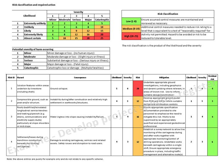
The Geotechnical Risk Register is an essential tool in tabular format for managing geotechnical risks to
the OO asset. In the context of reporting, it demonstrates to the OOGA (and OO) that the geotechnical
risks are being effectively recognised and mitigated by the DGA. The Geotechnical Risk Register
commences in the SoI and is subsequently updated throughout the project cycle through to the GFR
where any residual risks are recorded for operation/maintenance.
The risk register, together with the basis for scoring the occurrence and severity, presents the
geotechnical risks alongside their likelihood of occurrence and severity of impact with the product of
these being the risk rating. Only geotechnical risks are to be included in the geotechnical risk register.
An example of a geotechnical risk register is included in Figure B.1.
25CD 622 Revision 1 Appendix B. Geotechnical Risk Register
Figure B.1 Example of a geotechnical risk register
26CD 622 Revision 1 Appendix B. Geotechnical Risk Register
27CD 622 Revision 1 Appendix C. Recommended content for Statement of Intent
Appendix C. Recommended content for Statement of Intent
C1 Project
Name and details of the project including OO Reference No., brief description of location [including
National Grid Reference(s)], location plan and any areas outside the current OO asset to be included in
the project.
C2 Objectives
C3 Existing information
Summary of supporting information that has been identified to date.
C4 Geotechnical risk
1) Preliminary summary of key geotechnical risks that are envisaged including a preliminary
assessment of the likelihood of underground voids or mining (see also Section 8 and Appendix B).
2) An initial assessment of the geotechnical category
C5 Proposed studies and investigations
Outline of proposed studies and investigations that are to be undertaken to achieve geotechnical
certification.
C6 Specialist consultation
Details of any specialist consultations required with reasons
C7 Programme
Estimated programme of work involved in preparation of the PSSR, GISR and GIR and any physical
work required up to their completion.
28CD 622 Revision 1 Appendix D. Recommended content for preliminary sources s...
Appendix D. Recommended content for preliminary sources study report
D1 Title sheet(s)
Including the name of the project, the report title, details of the authorship, report and version number,
OO Reference No. and date of issue.
D2 Introduction
1) Reference to SoI and any subsequent changes to the project;
2) Limits of study area and record of relevant previous geotechnical studies;
3) Confirm or change the geotechnical category.
D3 Sources of information, desk study, site reconnaissance, site description and
review of findings
1) Details of all enquiries made and of all sources used for geotechnical, historical and other relevant
information with nil or negative responses also reported. The findings may be incorporated into
separate blocks in this section (for example statement of geological information consulted followed
directly by a review of findings);
2) The review carried out by the designer of all existing relevant geotechnical information (for example
geomorphological/geological mapping, GI work, drainage/hydrological studies, etc. Any included
relevant photographs should be clearly referenced;
3) Sources reviewed to include:
a) topographical maps;
b) historical maps;
c) geological maps (1:50,000 and 1:10,000 scale) and memoirs;
d) aerial photographs (old and recent);
e) records of mines and mineral deposits (including Mineral Valuer's report), drainage;
f)remote sensing data from third parties (for example satellite data);
g) as-built drawings;
h) existing monitoring data;
i)services drawings;
j)land use and soil survey information;
k) archaeological and historical investigations;
l)existing ground investigations (including relevant investigations carried out for the OO and the
results of those investigations);
m) relevant Information held on asset data systems operated by the OO or third parties. The OO
asset data management system should be interrogated to assist the assessment of geotechnical
risks;
n) consultation with statutory bodies and agencies, for example flood records.
D4 Site reconnaissance
1) Description of findings of site reconnaissance (site walkover) undertaken for this report;
2) Any recent geotechnical data obtained since the SoI.
D5 Ground conditions
1) Comprehensive study of information described in D3 & D4;
2) Description of soils and/or rocks identified in D3 & D4 items above with engineering properties and
significance of geotechnical conditions;
3) Contaminated land and ground-gas assessment (geoenvironmental assessment) as appropriate to
a highway project.
29CD 622 Revision 1 Appendix D. Recommended content for preliminary sources s...
D6 Preliminary engineering assessment
1) For each soil and/or rock type and/or location preliminary consideration of the design, construction
and operation implications including:
a) General - location, classification, earthworks acceptability criteria, groundwater, likely difficulties
and risks, areas/features to avoid;
b) Cuttings – side slopes (short- and long-term stability), potential acceptability of material, special
drainage or ground treatment, swelling/heave risks;
c) Embankments – side slopes, characteristics and restrictions on use of particular geomaterials,
plant use options, drainage requirements, foundation treatment, settlement;
d) Subgrade – likely strength assessment for cutting areas and for potential fill materials in
embankments, capping layers and availability of material, drainage requirements;
e) Structure foundations – alternative types of foundation likely to be applicable, high level
estimates of bearing pressures and settlements, groundwater, risk areas/strata, potential
construction difficulties etc;
f) Geochemistry – possibility of harmful elements (including gases) present in soil, rock or
groundwater and implications of these on human health and safety and deterioration of the
works. Scope for the reuse of marginal/recycled material within the works;
g) Any existing geotechnical risks such as slope failures, slopes with marginal factors of safety, very
soft/highly compressible soils and solution features, mine workings or other known void risks
(see Section 8);
h) Effects of man-made obstructions, archaeology, mining, site history etc.
D7 Comparison of project options and risks
1) Summarise all relevant geotechnical factors, which are likely to influence the OO asset and the
project;
2) An updated geotechnical risk register building on that included in the SoI;
3) Risks of undertaking proposed geotechnical engineering activities assessed and their management
described;
4) The geotechnical risks associated with the various routes/options for multi-option schemes;
5) A description of the geotechnical options considered and a statement of the preferred route/options
(on geotechnical grounds) if appropriate.
D8 Drawings and photographs
1) Site plan (including scale bar to allow clarity when on-screen viewing) with study limits and project
options. Plans to show geotechnical and geoenvironmental constraints and hazards. Geological
longitudinal sections with cross-sections where appropriate. Where appropriate, drawings should
present existing and proposed ground levels;
2) Photographs, both ground and aerial, used in the study should be reproduced and referenced to the
site plan.
30CD 622 Revision 1 Appendix E. Recommended content for Ground Investigation ...
Appendix E. Recommended content for Ground Investigation Scope
Report (GISR)
1) If a standalone report, on the title page include the name of the project, the report title, details of the
authorship, report and version number, OO Reference No., and date of issue;
2) If a standalone report, include the geotechnical risk register.
E1 Objectives
1) The scope of the ground investigation for a project, as discussed and agreed between the DGA and
the OOGA, also including land outside the current OO asset that falls within the scope of the works;
2) Specific risks to be investigated identified and described.
E2 Proposed investigation
1) Fieldwork - tabular details of exploratory work proposed with reasons for choice of investigatory
method with respect to mitigating previously assessed risks;
2) Laboratory work - tabular details of proposals with reasons for choice of test, relevance to previously
assessed geotechnical risks and benefits.
E3 Site and working restrictions
Known physical constraints to investigation works.
E4 Specialist consultation
Details of and reasons for, if proposed.
E5 Programme
Anticipated start dates, contract periods, restrictions on programme, cost estimates (VAT excluded) for
factual and interpretive work. Arrangements for contract work and supervision of contract.
E6 Reporting
Responsibility for reporting. Factual data supplied in electronic report format suitable for upload to the
OO record system and in AGS format.
31CD 622 Revision 1 Appendix F. Recommended content for Ground Investigation ...
Appendix F. Recommended content for Ground Investigation Report (GIR)
F1 Title sheet
1) Name of the project, the report title, OO Reference No., reference, details of the authorship, the
version number and date of the report.
2) Reference to SoI and PSSR. Description of project changes since the SoI and PSSR were produced.
F2 Introduction
1) Scope and objectives of the report;
2) Brief description of the project;
3) Geotechnical category;
4) Other relevant information.
F3 Existing information
A review presented by the designer of all existing relevant geotechnical information available on the
project. The PSSR will be a basis for this section but the information should be updated as necessary
when such information is of a time-limited nature.
F4 Field and laboratory studies
This section is to describe the investigations carried out by the designer as part of the design process:
1) geomorphological/geological mapping and topographic survey;
2) ground investigations (description of the investigations carried out by the designer, including an
outline of the aims and reasoning behind the requirement for the investigation);
3) description of fieldwork;
4) results of in situ tests;
5) drainage studies;
6) geophysical surveys;
7) test pile results;
8) other field work;
9) laboratory investigation;
10) description of tests;
11) factual data to be supplied in electronic report format suitable for upload to the OO's record system
and in AGS format.
F5 Ground summary
A summary interpretation of the results of the investigations undertaken and the derived material
parameters for design. Ground model(s) to be used for design to be presented either for the whole site
or for recognisably different areas of work. Where appropriate, drawings including any long sections
updated with new geotechnical or topographic data, etc. An update to the geoenvironmental model
should be presented including the findings of ground investigations.
F6 Geotechnical Risk Register
An update of the Geotechnical Risk Register.
32CD 622 Revision 1 Appendix F. Recommended content for Ground Investigation ...
F7 Engineering assessment
The designer's engineering assessment of all of the geotechnical and geoenvironmental information
gathered, including for land outside the OO current asset which falls within a scheme. The assessment
includes a description and justification of the geotechnical options that have been considered for use in
the scheme. It presents justified engineering reasoning for the chosen geotechnical option for all, or
individual elements, of the scheme for reference during technical approval in DMRB document CG 300
[Ref 8.I] (where relevant) and taken forward into the GDR.
F8 References
33CD 622 Revision 1 Appendix G. Recommended content for Geotechnical Design R...
Appendix G. Recommended content for Geotechnical Design Report
1) Include full details of the interpretation of design data and justification for the design and include
relevant layout drawings;
2) The report is to be subdivided into sections on cuttings, embankments, structures and, where SGM
are utilised, to be further subdivided for each unique earthwork or structure and submitted in
sections to suit the design and construction programme;
3) Include drainage design (both surface and sub-surface) relevant to earthworks, structures subgrade
design and capping;
4) Schedules and drawings (plans, elevations, sections with typical details, construction sequence,
risks (and their mitigations) cross referenced to specification appendices;
5) A discussion of contamination and remediation requirements (if required);
6) Description/diagram of idealised soil structure model(s) to be used in analysis;
7) Full description of proposed use of the observational method, if proposed and agreed by the OOGA,
including details of monitoring and control;
8) Any monitoring, control and maintenance required during the service life to be described.
G1 Cuttings
Full details of the methods of slope analysis/output, soil/rock parameters, drainage, slope angles,
formation parameters for pavement design and other considerations. Summary of design including
location, side slopes, maximum and typical depths, relevant site investigation, assumed soil/rock strata
and ground water conditions, earthworks, drainage requirements and pavement design. Information
may be tabulated or submitted as a series of summary forms.
G2 Embankments
Full details of the methods of analysis/output, soil parameters, drainage, slope angles, formation
parameters for pavement design and other considerations. Summary of design including location, side
slopes, maximum and typical depths, relevant site investigation, assumed soil strata and ground water
conditions, predicted settlements, earthworks, drainage requirements and pavement design.
Information may be tabulated or submitted as a series of summary forms.
G3 Highway structures
Full details of the structure type, method of analysis and soil parameters assumed in design of
foundations, retaining elements and the SGM. Summary of design including allowable bearing
pressures, pile capacity, earth pressures, differential settlement and protection against chemical attack
to be provided for each structure. Information may be either tabulated or submitted as a series of
summary forms.
G4 SGM
In addition to the above for slopes, embankments or structures as relevant, the working width (space
required for a system or method of working, for example vehicle restraint systems, access space, and
suchlike) of OO's assets cannot be compromised by the construction of geotechnical structures. In
particular the serviceability performance of potentially flexible SGM such as reinforced soil, soil nail
solutions, and similar requires careful consideration and reporting.
G5 Drainage
Details of how the drainage design will address the groundwater conditions and how groundwater risks
are to be managed.
G6 Pavement design, subgrade design (including the need for in-situ treatment,
etc.) and capping
Method of analysis, soil parameters, ground water assumptions.
34You can also read