Central Goldfields Shire Council - Planning Panels Victoria CGSC C031cgol PART A Submission
←
→
Page content transcription
If your browser does not render page correctly, please read the page content below
Central Goldfields
Shire Council
Planning Panels Victoria
CGSC C031cgol PART A
Submission
May 2020
Central Goldfields Shire Council
Planning Panels Victoria CGSC and NCCMA C031cgol Part A Submission
Author: Strategic Planner (CGSC) and Manager Floodplain (NCCMA)
Date: November 16 2020
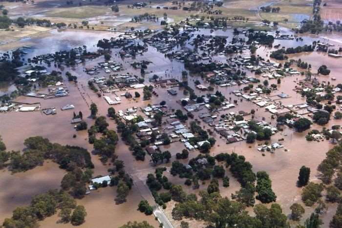
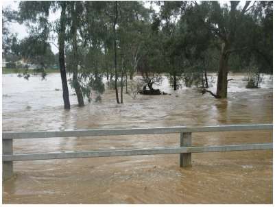
Photograph above Dunolly flood 2011
Photograph on cover Carisbrook flood 2011
Acknowledgement of Country
Central Goldfields Shire Council acknowledges the ancestors and descendants of the Dja Dja Wurrung. We
acknowledge that their forebears are the Traditional Owners of the area we are on and have been for many
thousands of years. The Djaara have performed age old ceremonies of celebration, initiation and renewal.
We acknowledge their living culture and their unique role in the life of this region.
Page 2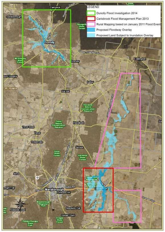
Central Goldfields Shire Council
Planning Panels Victoria CGSC and NCCMA C031cgol Part A Submission

Contents
REPORT
1        Introduction                                                5
1.1      Investigation Area                                          6
2        Background                                                  7
2.1      Flood Plans Developed for Carisbrook and Dunolly            7
2.2      Consultation for Flood Management Plans                     8
2.3      Mapping Extents                                             9
2.4      Adoption of the Plans                                       9
2.5      Recommendations of the Plans                                10
3        Preparation of Amendment C031cgol                           16
3.1      Mapping Schedule                                            17
4        Chronology of Events                                        18
5        Submissions                                                 19
5        Submission 1                                                19
5        Submission 2                                                20
5        Submission 3                                                20
5        Submission 4                                                21
5        Submission 5                                                23
5        Submission 6                                                24
5        Submission 7                                                24
5        Submission 8                                                25
5        Submission 9                                                25
5        Submission 10                                               25
5        Submission 11                                               25
5        Submission 12                                               26
6        Conclusion                                                  27
7        Appendix                                                    28

DIAGRAMS
1.1.1 Flood Study Investigation Areas in Carisbrook and Dunolly      6
2.6.1 Carisbrook Map – Infrastructure Mitigation Stage               12

Page 3
Central Goldfields Shire Council
Planning Panels Victoria CGSC and NCCMA C031cgol Part A Submission

2.6.2 Proposed Overlay Map – Stage Four Completion Carisbrook                                  12
2.6.3 Dunolly Map - Infrastructure Mitigation Stage                                            14

TABLES
Table 1: Carisbrook Flood and Drainage Management Plan 2013 recommendations                    10
Table 2: Dunolly Flood Investigation 2014 recommendations                                      11
Table 3: Mapping Schedule for Amendment C031cgol                                               17
Table 4: Chronology of Events for Amendment C031cgol                                           18
Table 5: Land discussed in each submission and status of overlay                               19

APPENDIX (visit HERE)
Officer Report to Council Seeking Authorisation
DELWP Letter providing Authorisation
Officer Report to Council Seeking Minister for Planning to Appoint Planning Panels Victoria
including Submission Table as Appendix
PPV Letter of Instrument
Exhibited Explanatory Report C031cgol
Exhibited Instruction Sheet C031cgol
Supporting Document - Carisbrook Bushfire Report Response to Clause 13.02
Supporting Document - Dunolly Bushfire Report Response to Clause 13.02
Exhibited Planning Scheme Maps
Carisbrook Flood and Drainage Plan 2013
Dunolly Flood Study 2014
AECOM report to Carisbrook Flood Study, 2013
Water Tech response to AECOM report, 2014
Investigation and Design of Carisbrook Flood and Drainage Mitigation Treatments, Preliminary
Design Entura 2015
Investigation and Design of Carisbrook Flood and Drainage Mitigation Treatments, Preliminary
Design Entura 2016
Jacobs Review 2017
Updated Hydrology and Hydraulic Report, AR&R 2016 and Water Technology 2019
Tullaroop Creek Rural Mapping NCCMA 2019

Page 4
Central Goldfields Shire Council
Planning Panels Victoria CGSC and NCCMA C031cgol Part A Submission

1        Introduction
Flooding is a natural process intrinsic to all waterways. Flooding occurs periodically as a result of
heavy rainfall within a catchment and is generally defined by the runoff from the storm event
exceeding the capacity of the bed and banks of a waterway or local drainage system.
The effects of flooding in Central Goldfields (CG) are magnified by the proximity of urban
development to natural or modified creeks and channels resulting in damage to roads, residential,
commercial and industrial properties. The impact of overland flow is also significant and causes
frequent flooding to a number of properties in Carisbrook.
The current flood controls in the Central Goldfields Planning Scheme (CGPS) are considered to be
out of date. Extensive research work has been completed since the flood controls were first
implemented. The North Catchment Management Authority (NCCMA) has undertaken the North
Central Regional Floodplain Management Strategy 2018-2028. After the floods of 2011-2012,
flood studies were conducted in Carisbrook and Dunolly in 2013-2014 (known as the Carisbrook
Flood and Drainage Management Plan 2013 and Dunolly Flood Investigation 2014). These studies
model the impact of flooding in both townships. In the summary recommendations, both regional
Strategy and local flood studies recommend that the planning scheme be updated to reflect the
extent of flooding in the updated mapping.
Amendment C031cgol (the Amendment) is the culmination of an extensive body of background
work and a consultation process which involved Government agencies, other stakeholders and the
wider community. Amendment C031cgol proposes to amend the CGPS to give effect to the
Carisbrook and Dunolly Flood Management Plans (the Plans). The Plans were prepared by Water
Technology in consultation with the NCCMA and Central Goldfields Shire Council (CGSC).
The area affected by the amendment falls within the McCallums Creek, Tullaroop Creek (known
locally as Deep Creek) and the Burnt Creek catchments, and local tributaries and the associated
floodplains for these watercourses. It therefore affects flood prone land in Carisbrook and Dunolly
which were included in the study area.
The amendment retains the existing Land Subject to Inundation Overlay – Schedule 1 (LSIO1),
which applies to land outside of this study area including Maryborough, Talbot, Moliagul, Bealiba
and surrounding districts. The study area subject to this amendment is proposed to be covered by
the LSIO2. The Amendment introduces the Flood Overlay (FO) into the planning scheme.
This submission documents the background to the Amendment, and the strategic and statutory
planning context in which the Amendment has been prepared. It also addresses the submissions
received during public exhibition. The submission relies on technical input from the NCCMA being
the key agency in collaboration with Council.

Page 5
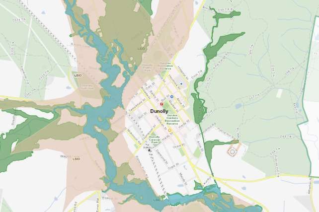
Central Goldfields Shire Council
Planning Panels Victoria CGSC and NCCMA C031cgol Part A Submission

1.1      Investigation Area
Map 1.1.1 Flood Study Investigation Areas in Carisbrook and Dunolly

Page 6
Central Goldfields Shire Council
Planning Panels Victoria CGSC and NCCMA C031cgol Part A Submission
2 Background
The townships of Carisbrook and Dunolly in central Victoria have been affected by several flood
events from overland flooding and rising levels in the McCallums, Deep and Burnt Creeks.
Significant and devastating flood events occurred in September 2010 and January 2011.
2.1 Flood Plans Developed for Carisbrook and Dunolly
The first stage in managing floodplain risk for a particular catchment involves a flood study, which
is a comprehensive technical investigation of flood behaviour for that catchment. These flood
studies show the distribution, extent, levels and velocity of floodwaters across sections of the
floodplain for a range of different flood events.
The Plans were jointly funded by the Victorian and Australian Governments under the Natural
Disaster Resilience Grants Scheme (NDRGS), with additional funding provided by NCCMA and
CGSC. The NCCMA developed the Plans in partnership with CGSC.
The objectives of the Plans included:
A review of available data and historic flood information and simulation of various past flood
events through the townships;
Engagement with the community and stakeholders in order to understand their experiences of
flooding and desired outcomes;
Determination and documentation of flood levels, extents, velocities and depths (and thus flood
risk) for the Deep Creek and Burnt Creek and any major tributaries within the study area (Map
1) for a range of flood events including 0.5%, 1%, 2%, 5%, 10% and 20% AEP events;
A review of the Central Goldfields Planning Scheme’s current flood zone and overlays for the
township/study area/locality and recommendations for appropriate Planning Scheme
amendments in the context of study outcomes;
Preparation of digital and hard copy floodplain maps for 1% AEP flood events showing both
floodplain and floodway extents, suitable for incorporation into municipal planning schemes;
Assessment of flood damages;
Identification and preliminary feasibility assessment of structural mitigation measures to
alleviate intolerable flooding risk;
Costing and assessment of preferred structural mitigation measures.
Note: The September 2010 event was estimated as a 75 year ARI event with the January 2011
estimated to be much larger at a 135 year ARI event.
Page 7
Central Goldfields Shire Council
Planning Panels Victoria CGSC and NCCMA C031cgol Part A Submission

2.2 Consultation for Flood Management Plans

The Carisbrook Plan summarises the consultation and feedback process (pg. v):

A key objective of the Plan was to ensure strong community engagement and to demonstrate
strong community support for the final Plan. A key aspect of all community engagement was to
provide information to ensure community understanding and then to seek feedback verbally at
meetings and through more formal feedback methods such as surveys. Three public meetings held
at various stages of the Plan development were all strongly attended with over 100 community
members present at each meeting. Feedback from these meetings guided the development of the
Plan. Key findings of the Draft Carisbrook Flood Mitigation and Drainage Management Plan were
presented to the community at a public meeting held on 15th February 2013. A summary brochure
outlining the mitigation packages and preferred option along with a feedback form was provided to
all meeting attendees and a three week consultation period then ensued. During the public
consultation the community provided a total of 113 submissions were received from the
community, with 100 submissions supporting the preferred option and 13 not supporting the
preferred option or unsure. As a result of the extensive community consultation, and public
feedback, it is clear that the Steering Committee’s proposed scheme for Carisbrook has strong
community support.

The Dunolly Plan summarises the consultation process (pg. vii):

Throughout the study, a range of community consultation activities were undertaken, including
community drop-in sessions, media releases and questionnaires to ensure that community issues
were heard and the ideas of the community were considered in the development of potential flood
mitigation options. It must be noted that the community participation was very helpful, with flood
observations, local information and feedback on the study greatly improving the outcomes for the
study.

Page 8
Central Goldfields Shire Council
Planning Panels Victoria CGSC and NCCMA C031cgol Part A Submission

2.3 Mapping Extents

The mapping produced by the Plans will improve future land use planning and development
decisions to minimise the risks to the community from flooding. The Plans also support the
NCCMA, Council and other emergency response organisations in preparing for and responding to
a flood in Central Goldfields Shire. The Plans will also assist Council in understanding existing
drainage problems and in designing new infrastructure.

The Plans established the 10% and 1% AEP* flood levels using a robust methodology that relied
on a range of data sources including consideration of stream flow and rainfall data, surveyed flood
level data, LiDAR data, storage data and a broad range of background data from various sources
including drainage studies and site specific flood event data.

A 1 in 100 year ARI* flood is a level of flooding that has a 1% chance of occurring in a given year.
It is considered to be a very large flood and is used as the minimum design standard for new
development in Victoria. If an area experiences a 1 in 100 year flood in a certain year, it does not
mean that another 1 in 100 year flood will not occur for another 99 years, it is an average only. The
1 in 100 year flood is technically referred to as the 1% AEP* flood.

* Average Recurrence Interval – is the likelihood of occurrence, expressed in terms of the long-
term average number of years, between flood events as large as or larger than the design flood
event. For example, floods with a discharge as large as or larger than the 100 year ARI flood event
will occur on average once every 100 years.

*Annual Exceedance Probability – is the likelihood of occurrence of a flood of given size or larger
occurring in any one year. AEP is expressed as a percentage (%) risk and may be expressed as a
reciprocal of ARI* (Average Recurrence Interval).

2.4 Adoption of the Plans

The Carisbrook Flood and Drainage Management Plan was received by Council on 27 August
2013.

The Dunolly Flood Investigation was delivered to Council on 21 October 2014.
A recent records check has indicated that Council received the completed Carisbrook and Dunolly
Plans but did not formally resolve to adopt them. Council proposes that Panel include a
recommendation to Council to formally adopt the Plans when the Amendment is presented to
Council for adoption.

Page 9
Central Goldfields Shire Council
Planning Panels Victoria CGSC and NCCMA C031cgol Part A Submission

2.5 Recommendations of the Plans
The Plans made a range of recommendations, as follows:

The Carisbrook Plan

Table 1: Carisbrook Flood and Drainage Management Plan 2013 recommendations

 Details                                                             Recommendation Implemented

                                                                     Partially complete - requires
 A Western Floodway and Levee to divert overland flows to the        additional funding to complete
 west of the township                                                work – estimate 2022 (see below)

 Vegetation works on Tullaroop and McCallums Creek extending         Works are complete, which were
 from Camp Street to a point 500 m downstream of the railway
 bridge                                                              managed by NCCMA on behalf of
                                                                     CGSC
 A smaller levee near Williams Road to divert additional overland
 flow into McCallums Creek through the existing bluestone drain      Works completed by CGSC (see
                                                                     below)

 A non-return valve on culverts under Landrigan Road near
 Camp Street                                                         Works completed by CGSC (see
                                                                     below)

 A long-term recommendation that the highway bridge be
 replaced with a clear-span structure when the bridge is due for     Vicroads future project (no dates
 replacement (or when funding becomes available).
                                                                     set – long term action)

 The staged implementation of a flood warning system for
 Carisbrook which may include several new rainfall gauges in the
                                                                     Partially complete. Future action
 upstream catchments (at the Carisbrook local catchment,
                                                                     funding will be sought by NCCMA
 Smeaton, Clunes and the upper McCallums Creek catchment)
                                                                     in 2021 to progress further.
 and a new stream flow gauge and boards to be installed at
 Carisbrook (upstream of the highway bridge).
 The flood warning system should be utilised in conjunction with     Future works required -
 the flood maps and flood intelligence produced from this study to
 form an effective flood warning system;                             Emergency Agency partners
                                                                     (VicSES, CGSC and NCCMA)
 It is recommended that a flood response plan be adopted into
 the Municipal Flood Emergency Plan and the community is
 engaged along with the responsible agencies (BoM, SES, CGS,         Complete, CGSC
 NCCMA etc.) in developing appropriate actions.

Page 10
Central Goldfields Shire Council
Planning Panels Victoria CGSC and NCCMA C031cgol Part A Submission
The planning scheme for Carisbrook is amended to reflect the
flood risk identified by this project (pg. 137) Progressed 2019 by CGSC and
NCCMA
The Dunolly Plan
Table 2: Dunolly Flood Investigation 2014 recommendations
Details Recommendation Implemented
An upgrade of the contour channel to improve capacity, and Works completed by CGSC (see
the incorporation of a retarding basin. below)
Amendment of the planning scheme for Dunolly to reflect the Progressed 2019 by CGSC and
flood risk identified by this project NCCMA
Mitigation Package 3 (an upgrade of the contour channel and Works completed by CGSC (see
retarding basin) to be submitted for funding for detailed design
and construction. below)
The updated Municipal Flood Emergency Plan be used during
a flood event to improve the emergency response. Complete, CGSC
In any future bridge upgrade projects, consideration be given
to elevating bridges to provide access during a major flood Vicroads future project (no dates
because currently the town becomes completely isolated by set)
road.
Installation of a gauge board within town to base future
observations on and to tie the flood maps back to the gauge.
This gauge could also be linked to a flash flood warning Works completed by DELWP.
system should that be considered in the future.
This Amendment C031cgol proposes to incorporate the new flood mapping produced by the Plans
into the CGPS. It proposes to introduce the Flood Overlay (FO) and apply a new Land Subject to
Inundation Overlay – Schedule 2 (LSIO2). The purpose of this is to provide transparent information
about local flood hazards and appropriate consideration and identification of risk where land
development is proposed.
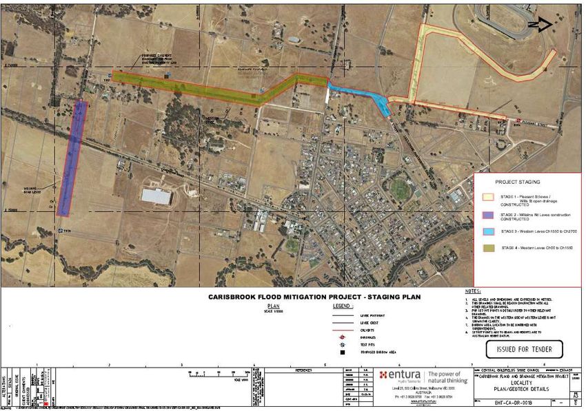
2.6 Mitigation Infrastructure
Carisbrook
As mentioned above several flood mitigation options were recommended for Carisbrook in the
Plan. The Carisbrook map below shows the Williams Road section of the levee (Stage 2) which is
completed and Western Levee (Stage 1) has been constructed. The levee in Stage 1 is the road
of Pleasant St, the area shaded around the racecourse is open drainage related works.
Page 11Central Goldfields Shire Council Planning Panels Victoria CGSC and NCCMA C031cgol Part A Submission 2.6.1 Carisbrook Map – Infrastructure Mitigation Stages Stage 3 is currently underway and Stage 4 is waiting for funding. Preliminary mapping by the CMA has proposed what the flood mapping may look like with the Stage 4 mitigation options complete. The completion of Stage 3 (which is currently being constructed) will not reduce flood risk, this will only occur once Stage 4 is complete. Page 12
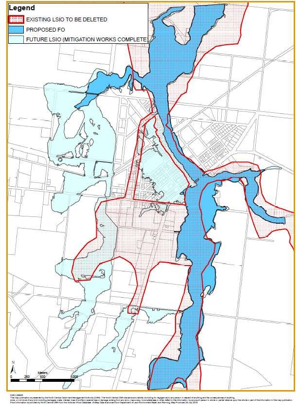
Central Goldfields Shire Council
Planning Panels Victoria CGSC and NCCMA C031cgol Part A Submission

2.6.2 Proposed Map – Stage Four Completion Carisbrook*

* The map above shows the LSIO as current in the CGPS. Council anticipates implementing the
revised flood mapping via a Section 20(4) Amendment once Stage 4 of the Western Levee is
completed.

Page 13
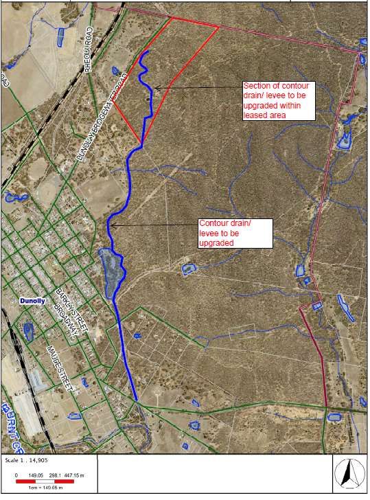
Central Goldfields Shire Council
Planning Panels Victoria CGSC and NCCMA C031cgol Part A Submission

Dunolly
As mentioned above two flood mitigation options were recommended for Dunolly in the Plan. The
Dunolly Levee is from the Dunolly Bridgewater Rd to Dunolly Eddington Rd. This work is
complete.

2.6.3 Dunolly Map - Mitigation Infrastructure Stages

Page 14
Central Goldfields Shire Council
Planning Panels Victoria CGSC and NCCMA C031cgol Part A Submission

2.7 Further Studies and Mapping Reviews
There have been a number of studies and reviews subsequent to the completion of the Flood
Management Plans. The following details the additional studies that have been undertaken which
focus on Carisbrook.

2.7.1 AECOM Review 2013
Prior to adopting the Carisbrook Flood Management Plan, CGS engaged the services of AECOM
to review the Plan. A copy of the review is attached in the Appendices. The review raised some
issues. This review was forwarded to Water Technology for consideration. A copy of Water
Technology’s response that addresses these issues is attached in the Appendices.

2.7.2 Investigation and Design of Carisbrook Flood and Drainage Mitigation Treatments – Preliminary
Design, Entura 2015
Entura was awarded a contract by CGS to investigate and cost two overland flow flood mitigation
options. This stage of the design involved remodelling flood flows in Carisbrook. A copy of this
report is attached in the Appendices.

2.7.2 Investigation and Design of Carisbrook Flood and Drainage Mitigation Treatments – Detailed
Design, Entura 2016
Entura was awarded a contract by CGS to develop a detailed design for flood mitigation works to
address the overland flooding in Carisbrook. A copy of this report is attached in the Appendices.

2.7.3 Jacobs Review, 2017
Jacobs was engaged by the Department of Environment Land Water and Planning (DELWP) in
2017 to conduct a peer review of the Carisbrook Flood and Drainage Management Plan and flood
mitigation works completed at that time. CGS was investigating the option to compulsorily acquire
land to facilitate the construction of works, this review was considered an important step by
DELWP to ensure that any decisions made by the Minister for Planning was based on the best
available information. A copy of this review in attached in the Appendices.

2.7.4 Updated Hydrology and Hydraulic Report – AR&R 2016, Water Technology 2019
Following on from the recommendations of the Jacobs Review, 2017, CGS engaged the services
of Water Technology to update the flood modelling and to understand the impacts of the partially
completed flood mitigation works (Stages 1&2). A copy of this report is attached in the Appendices.
The results of this flood modelling was used to prepare the proposed overlays for Carisbrook.

2.7.5 Tullaroop Creek Rural Mapping, North Central CMA 2019
The detailed modelling undertaken by Water Technology highlighted the significant inaccuracies in
the existing LSIO and there was no logical or easy way to transition the new LSIO into the existing
LSIO. Given the collection of data during the January 2011 flood event including video footage,
North Central CMA has taken this opportunity to undertake rapid mapping for the rural areas along
Tullaroop Creek. A copy of the report summarising the methodology of this mapping is attached in
the Appendices.

Page 15
Central Goldfields Shire Council
Planning Panels Victoria CGSC and NCCMA C031cgol Part A Submission
3 Preparation of Amendment C031cgol
At the Ordinary Meeting of Council on 19 December 2019, Central Goldfields Shire Council
Administrators authorised Council to progress with the Council as the planning authority. Section
8A (2) of the Act stipulates that a municipal Council may only prepare an amendment to a Planning
Scheme if it is authorised to do so by the Minister for Planning. The amendment was authorised by
DELWP on the 25 February 2020.
The amendment proposes to alter the CGPS by:
Introducing the FO. This is to be applied to land that is subject to mainstream flooding and
has been identified as
o having a depth of flooding greater than 0.5 metres; or
o having a product of depth and velocity greater than 0.4 metres2/second; or
o affected by flooding from a 10% AEP flood event (subject to flooding on average once
in every 10 years).
Adding a second schedule to the Land Subject to Inundation Overlay (LSIO2). This is to be
applied to land that is subject to mainstream flooding and has a lower risk of flooding than
FO land by having a 1% AEP flood extent (subject to flooding on average once in every 100
years).
Updating the mapping extent of the LSIO1 for the rural areas of Tullaroop Creek upstream
and downstream of Carisbrook.
Introducing planning permit exemptions to those flooding controls if certain requirements are
met.
The proposed changes to the planning scheme will affect approximately 911 properties, as follows:
146 properties are proposed to have the current LSIO removed.
10 properties are proposed to have the FO applied.
481 properties are proposed to have the LSIO applied.
274 properties are proposed to have both the FO and the LSIO applied.
Of the 765 properties that are proposed to have flood controls, 306 properties are proposed to
have flood controls applied for the first time.
In terms of specific changes to the CGPS the following changes were exhibited:
Ordinance changes
Amending Clause 21.09 of Municipal Strategic Statement to highlight the importance of
managing development within land in the Land Subject to Inundations Overlay and
discouraging development on land in the Floodway Overlay in the townships of Carisbrook
and Dunolly*.
Inserting Clause 44.03 (Floodway Overlay) into the planning scheme.
Inserting Schedule 1 to Clause 44.03 (Floodway Overlay) to identify properties that
experience flooding greater than 500 millimetres flood depth and provide permit exemptions.
Amending the Schedule to Clause 44.04 (Land Subject to Inundation Overlay) to identify it as
Schedule 1 to the Land Subject to Inundation Overlay.
Inserting Schedule 2 to Clause 44.04 (Land Subject to Inundation Overlay) to identify
properties that experience flooding less than 500 millimetres flood depth and provide permit
exemptions.
Amending Clause 72.08 to include the Carisbrook Flood and Drainage Management Plan
2013 and the Dunolly Flood Management Plan 2014 as background documents in the
planning scheme.
Page 16Central Goldfields Shire Council
Planning Panels Victoria CGSC and NCCMA C031cgol Part A Submission
*Ordinance changes due to recently completed Amendment C032cgol have changed the local
planning policy framework. This implication is expanded in the Part B submission.
Mapping changes
Amend the following overlay maps 4LSIO-FO, 5LSIO-FO, 7LSIO-FO, 13LSIO-FO, 14LSIO-
FO, 16LSIO-FO, 20LSIO-FO, 19LSIO-FO.
To view the map sheets visit HERE or view in the Appendix.
3.1 Mapping Schedule
Table 3: Mapping Schedule for Amendment C031cgol
Reference Information
Map04 Dunolly retract LSIO and introduce LSIO2 and FO1 (large area)
Dunolly retract LSIO and introduce LSIO2 and FO1 Thomas Street – Clark
Map05
Street area
Map07 Carisbrook and Dunolly retract LSIO and introduce LSIO2 and FO1 (large area)
Carisbrook retract LSIO and introduce LSIO2 and FO1 – Heales Rd to Victoria
Map13
Street
Carisbrook retract LSIO and introduce LSIO2 and FO1 – Veales Rd to
Map 14
Pyrenees Hwy
Map16 Carisbrook South retract LSIO and introduce LSIO2 and FO1 (large area)
Map19 Tullaroop Creek (Carisbrook South) retract LSIO introduce LSIO2 (large area)
Page 17Central Goldfields Shire Council
Planning Panels Victoria CGSC and NCCMA C031cgol Part A Submission
4 Chronology of Events
Table 4: Chronology of Events for Amendment C031cgol
Date Event
2010 - 2011 Carisbrook and Dunolly affected by two significant flooding events
2013-2014 Carisbrook and Dunolly Flood Management Plans completed
Review of Carisbrook Plan by AECOM with subsequent response by Water
May 2013
Technology
August 2013 Carisbrook Flood and Drainage Management Plan Presented to Council
2014-15 Detailed Design of Mitigation Works for Carisbrook by Entura
August 2019 Updated flood modelling undertaken by Water Technology
2019 Preparation of Amendment C031cgol commenced by the CGSC and NCCMA
25 February
Authorisation of Amendment C031cgol received from DELWP
2020
22 May – 23
Exhibition of Amendment C031cgol
July, 2020
17 – 19 June,
Public information sessions (via videconference)
2020
25 August
Council resolves to refer submissions to Amendment C031cgol to PPV
2020
27 August
Appointment of PPV formally requested
2020
10 September
Amendment C032cgol gazettal, implementing the PPF
2020
27 October
Directions Hearing
2020
23 November
Panel Hearing
2020
Page 18Central Goldfields Shire Council
Planning Panels Victoria CGSC and NCCMA C031cgol Part A Submission
5 Submissions
Table 5: Land discussed in each submission and status of overlay
Current Overlay Proposed
Submission Address of land
status Overlay status
5,7,9,11,13,15,19 (Town Hall),
Submission 1 21, 23, 29 and 31 Bucknall Part LSIO LSIO
Street Carisbrook
Submission 2 70 Landrigan Rd Carisbrook LSIO Part LSIO
Submission 3 52 Victoria St Carisbrook LSIO Part LSIO
Part FO and Part
Submission 4 33 MacCallum St Carisbrook Part LSIO
LSIO
Submission 5 42 Pierce Hill Rd Dunolly No LSIO No LSIO*
Submission 6 9 Bucknall St Carisbrook Part LSIO LSIO
Submission 7 N/A
Submission 8 N/A
Submission 9 N/A
Submission 10 N/A
Whole of Carisbrook
Submission 11 Part LSIO Part LSIO and FO
Investigation Area
Submission 12 N/A
* Council and NCCMA have agreed that this should be altered so that no LSIO is to affect the subject land. Discussed in
Part B Submission.
The submissions were considered by Council at its Ordinary meeting on 25 August 2020, at which
Council in accordance with Section 23 of the Planning and Environment Act 1987 resolved to refer
the submissions to a Panel appointed under Part 8.
The following sets out the details of the submissions, including maps showing the land to be
affected, followed by a discussion and then Council’s response.
5.1 Submission 1 – Private Submitter
Nature of Submission
The submission does not support the proposed LSIO over the western side of Bucknall Street
Carisbrook - lots 5,7,9,11,13,15,19 (Town Hall), 21, 23, 29 and 31 Bucknall Street. The
Page 19Central Goldfields Shire Council Planning Panels Victoria CGSC and NCCMA C031cgol Part A Submission submission states that these lots are islands of land that are not at risk for flood activity (as shown on the Flood Eye as not being affected by a 1 in 100 year flood). Council notes that these sites have existing LSIO controls applied, on the eastern portion of the lots (covering the islands). Resolution Subsequent to Council’s correspondence and discussion at the Carisbrook videoconference on the 18 June 2020, the submission was withdrawn (14 July 2020). 5.2 Submission 2 – Private Submitter Nature of Submission The submission does not support the proposed LSIO over the eastern side of the property boundary, along Landrigan Road. The submitter contends that the flooding that occurs in this area is due to a drainage fault, not rising creek water or overland flows. Council notes that the site is currently entirely constrained by the LSIO. Resolution Council relies on the recommendations of the Flood Management Plan and post submission comments from NCCMA, and is of the view that the proposed overlays be adopted as exhibited for this land. Page 20
Central Goldfields Shire Council
Planning Panels Victoria CGSC and NCCMA C031cgol Part A Submission
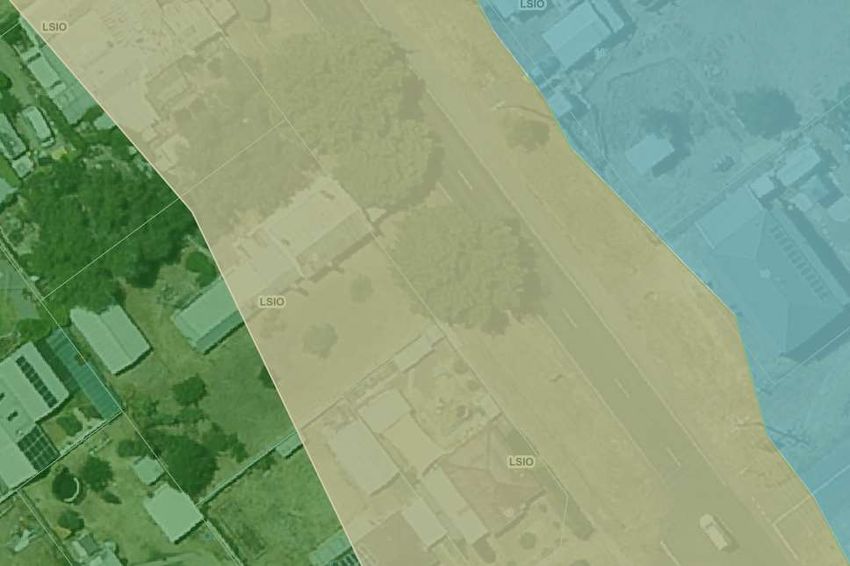
5.3 Submission 3 – Private Submitter
Nature of Submission
The submission suggests that the LSIO should be extended over 52 Victoria Street, Carisbrook. In
the landowner’s experience, this land is the same level as nearby lots and floods in the same way.
The submission also raises concerns with how flood risk will be reduced due to the construction of
the Western Levee, Carisbrook. The submissions contend this future project needs to be
considered in the current amendment.
Council notes that the site is currently entirely constrained by the LSIO.
Figure 3: Proposed 52 Victoria Street, Carisbrook Mapping
Page 21Central Goldfields Shire Council
Planning Panels Victoria CGSC and NCCMA C031cgol Part A Submission
Resolution
The NCCMA and Council consider this site area for further investigation and recommend PPV
make the necessary changes to the proposed mapping if required.
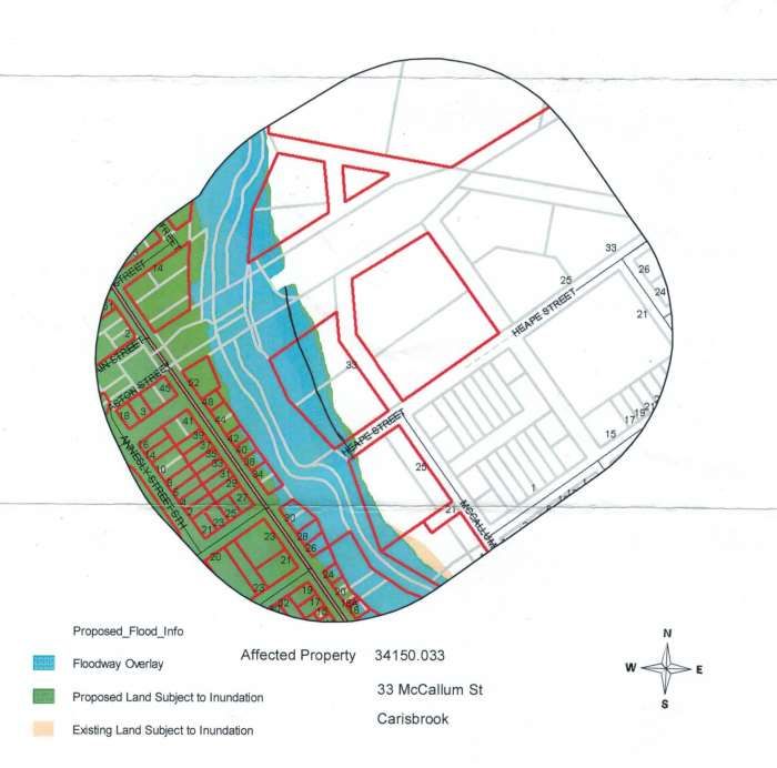
5.4 Submission 4 – Private Submitter
Nature of Submission
The submission does not support the proposed LSIO and FO on the western area of 33 McCallum
Street. The submitter contends that this ‘flood level’ was corrected by the NCCMA in 2013 and
should be set further west by a nominated amount as drawn on Figure 4 below (note the black
line).
Figure 4: Proposed 33 McCallum Street, Carisbrook Mapping
Council notes that the subject site is partly constrained by the LSIO, roughly in the same location
as indicated by the submitter’s line in the above map.
Page 22Central Goldfields Shire Council
Planning Panels Victoria CGSC and NCCMA C031cgol Part A Submission
Resolution
Council relies on the recommendations of the Flood Management Plan and post submission
comments from NCCMA, and is of the view that the proposed overlays be adopted as exhibited for
this land.
5.5 Submission 5 – Private Submitter
Nature of Submission
The submission does not support the proposed LSIO over a section of the property at 40 Pierce
Hill Rd, Dunolly. The submitter agrees that although the direction of the water flow is correct, the
extent of the inundation is inaccurate. The landowner contend that the water in the gully is at most
1m wide and approximately 30-40cm deep.
Figure 5: Exhibited Mapping in C031cgol, 40 Pierce Hill Road, Dunolly (site indicated)
Resolution
Council and NCCMA support mapping changes to Amendment C031cgol as shown above in
Figure 5.
The submission was withdrawn in the 29 July 2020 as the submitter believes their request was
resolved with the mapping update.
Page 23Central Goldfields Shire Council
Planning Panels Victoria CGSC and NCCMA C031cgol Part A Submission
5.6 Submission 6 – Private Submitter
Nature of Submission
The submitter contends that the mitigation works associated with the western levee should be
completed prior to Amendment C031cgol.
Council notes that the lot is currently constrained on the east by the LSIO, as shown below.
Photograph 2: Existing and Proposed mapping on 9 Bucknall Street, Carisbrook
Resolution
Council relies on the recommendations of the Flood Management Plan and post submission
comments from NCCMA, and is of the view that the proposed overlays be adopted as exhibited for
this land.
5.7 Submission 7 – Referral Authority
Nature of Submission
Coliban Water has no concerns with the proposed amendment to the Planning Scheme based on
the information provided.
Resolution
No action is required.
Page 24Central Goldfields Shire Council
Planning Panels Victoria CGSC and NCCMA C031cgol Part A Submission
5.8 Submission 8 – Referral Authority
Nature of Submission
The EPA has no concerns with the proposed amendment to the Planning Scheme based on the information
provided.
Resolution
No action is required.
5.9 Submission 9 – Referral Authority
Nature of Submission
CHW has no concerns with the proposed amendment to the Planning Scheme based on the information
provided.
Resolution
No action is required.
5.10 Submission 10 – Referral Authority
Nature of Submission
GMW has no concerns with the proposed amendment to the Planning Scheme based on the information
provided.
Resolution
No action is required.
5.11 Submission 11 – Private submitter
Nature of Submission
The submitter requests that the amendment be heard in a public meeting in Carisbrook.
The submission requests that the LSIO2 be extended over the Carisbrook Primary School, Tullaroop Leisure
Centre and the Mill if the Carisbrook township is included in the current mapping.
The submitter also requests that the Amendment be withheld until after the western levee construction.
Additional Information
Subsequent meeting with Submitter 11 held on 6 November 2020 in Carisbrook confirmed the
following position:
The Submitters request the mapping be amended to include the Carisbrook Primary
School, Carisbrook Leisure Centre and Chaff Mill in the LSIO;
The Submitters request that a recommendation be given that once Stage 4 of the Western
Levee is complete, Council immediately progresses with a Section 20(4) amendment to
remove the land no longer subject to planning controls to identify 1 in 100 year flood risk.
Resolution
Council relies on the recommendations of the Flood Management Plan and post submission
comments from NCCMA, and is of the view that the proposed overlays be adopted as exhibited for
Page 25Central Goldfields Shire Council Planning Panels Victoria CGSC and NCCMA C031cgol Part A Submission this land. Council affirms its position that once the Stage 4 of the Western Levee is completed, they will progress the steps required with DELWP to complete a Section 20(4) amendment. 5.12 Submission 12 – Referral Authority Nature of Submission CFA has no concerns with the proposed amendment to the Planning Scheme based on the information provided. Page 26
Central Goldfields Shire Council
Planning Panels Victoria CGSC and NCCMA C031cgol Part A Submission

6         Conclusion
The Amendment aims to update flood mapping in Carisbrook and Dunolly as recommended in the
Plans. The Amendment retains the existing LSIO1 which will apply to land outside of this study
area including Maryborough, Talbot, Moliagul, Bealiba and surrounding districts. The study area
subject to this amendment is proposed to be covered by the LSIO2 and FO1.
The Amendment is the culmination of an extensive body of background work and a consultation
process which involved Government agencies, other stakeholders and the wider community. This
exhibition process was shaped differently due to the COVID-19 Pandemic, yet still operated in
accordance with legislative requirements.
The amendment received 12 submissions, seven of which have been resolved. Five are
unresolved and Council and NCCMA’s response to these submissions will be publicly available in
the Part B Submission.

Page 27
Central Goldfields Shire Council
Planning Panels Victoria CGSC and NCCMA C031cgol Part A Submission

7         Appendix
Officer Report to Council Seeking Authorisation
DELWP Letter providing authorisation
Officer Report to Council Seeking Minister for Planning to Appoint Planning Panels Victoria
including Submission Table as Appendix
PPV Letter of Instrument
Exhibited Explanatory Report C031cgol
Exhibited Instruction Sheet C031cgol
Supporting Document - Carisbrook Bushfire Report Response to Clause 13.02
Supporting Document - Dunolly Bushfire Report Response to Clause 13.02
Exhibited Planning Scheme Maps
Carisbrook Flood and Drainage Plan 2013
Dunolly Flood Study 2014
AECOM report to Carisbrook Flood Study, 2013
Water Tech response to AECOM report, 2014
Investigation and Design of Carisbrook Flood and Drainage Mitigation Treatments, Preliminary
Design Entura 2015
Investigation and Design of Carisbrook Flood and Drainage Mitigation Treatments, Preliminary
Design Entura 2016
Jacobs Review 2017
Updated Hydrology and Hydraulic Report, AR&R 2016 and Water Technology 2019
Tullaroop Creek Rural Mapping NCCMA 2019

Page 28
You can also read