The Historic Landscape - at Auburn House - March 2021
←
→
Page content transcription
If your browser does not render page correctly, please read the page content below
The Historic Landscape
         at Auburn House

                  March 2021
                      Issue 3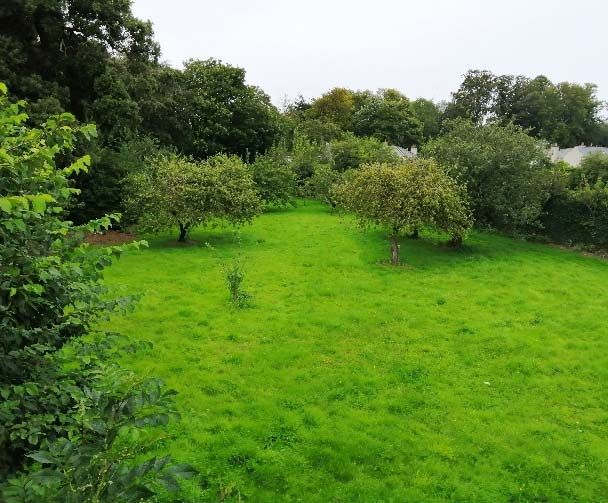
The Historical Landscape at Auburn House   2
Issue 3
The Historic Landscape at Auburn House

          1.0       Introduction
          2.0       Landscape heritage and design influence
                x   Vista (towards Malahide Demesne)
                x   Drive
                x   Parkland setting
                x   Woodland (framing views, amenity and shelter)
                x   Waterways and ditches (stream, bridge and ditches)
                x   Walled Garden
                x   Sculpture/recreational architecture
          3.0       Conservation and Mitigation Measures within the proposed development
                x   Vista
                x   Drive
                x   Parkland setting
                x   Woodland Management Plan/provision of public space
                x   Waterways
                x   Walled Garden
                x   Retention of sculptural elements
          4.0       Conclusion

The Historical Landscape at Auburn House                                                   3
Issue 3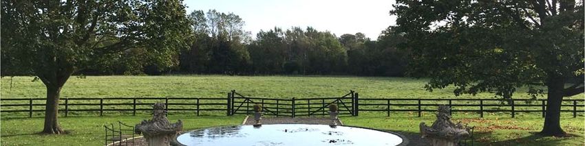
1.0 Introduction
Auburn House and estate is located off Malahide Road opposite the grounds of Malahide Castle
Demesne, 2km south of Malahide, Co. Dublin. The estate extends for 13.3ha. and in addition to
Auburn House and stable block, comprises several fields laid out in agricultural use (horse
grazing), woodland, walled garden and ancillary structures previously converted to residential
use.
Auburn House consists of a 5 bay three storey over basement dwelling with associated stable
block to the rear. In Turtle Bunbury’s history of Auburn Estate, the author describes the house as
being one of the finest residences built in Ireland in the 18th century. He depicts the house as a
‘golden-brown three storey mansion located in a wooded demesne adjacent to Malahide Castle’.
The Rocque’s map of County Dublin (1760) identifies buildings on the land at Auburn, on the
south side of ‘Peas Fields Hill’. The Crawford family had become landowners in the Auburn area,
having originated in Fermanagh where they were prosperous merchants. Auburn House was
constructed in c. 1779. One of the Crawfords had married into the Vernon family of Clontarf Castle
and the house was likely constructed to mark this marriage. The courtyard, stable block and
walled gardens were built presumably at the same time as the main building.
The house is approached from Malahide Road opposite the southern gate lodge associated with
Malahide Castle Demesne. Rendered convex flank walls in combination with lower pedestrian
gate piers with wrought iron pedestrian gates form the entrance. A narrow winding driveway
enclosed by mature woodland ensures that views are deliberately contained. A stone bridge over
the stream, provides a subtle change of character as views open up northwards providing glimpse
views of the estate landscape with the woodland as a pleasant backdrop.
The estate lands while relatively small in size by the standards of that period, still contain similar
features to that of larger estates. These features include woodland, a walled garden and orchard
and ancillary structures relating to the walled garden previously converted to residential use.

Figure 1: Aerial image of Auburn House and surrounds (Google Earth 2019)

The Historical Landscape at Auburn House                                                         4
Issue 3

2.0       Landscape Heritage and Design Influence
The architecture of the period was based on a more refrained design style, with straight edges
and often square symmetrical shapes predominating, as was the case in the design of Auburn
House. Many of the houses were also placed in grand landscapes and the landscape architectural
movement of the time, couldn’t have been more different. The inspiration for the design of the
landscape at Auburn House and may of the large houses throughout Ireland and Britain came
from the English landscape garden. The philosophy behind the English landscape garden was
Naturalism, favouring curved lines, gentle slopes, lakes and woodlands, moving away from the
strict formal geometric gardens of the Baroque period. These gardens were designed to look
natural and be a place for meditation and relaxation.
Lancelot ‘Capability’ Brown was the most successful practitioner of this approach in the second
half of the 18th century. He was responsible for the design of over 200 parklands across England.
Brown’s materials could scarcely have been simpler, utilising earth, water and trees, all of which
were employed at Auburn House.
Characteristics of the English landscape garden included:

     x    Vista
     x    Drive
     x    Parkland setting
     x    Woodland
     x    Waterways
     x    Walled garden
     x    Sculpture, recreational architecture/ruins/follies


Figure 2: Auburn House and lands – 1837 OSi Historic 6” mapping

The Historical Landscape at Auburn House                                                     5
Issue 3
The Vista
Many of the above design interventions are present at Auburn House. The house itself was built
on lands extending to 13 hectares (32 acres) and at a slight elevation, to capture the vista with
views orientated north-eastwards towards Malahide Castle and framed with mature trees and
field hedgerows. This visual connection is identified within the Streamstown LAP as being of
historical significance.
Visual connections were important within the designed landscapes of the period. Auburn House
was designed and orientated north-eastwards towards Malahide Castle. The visual connection
towards Malahide Castle was achieved by the framing woodland north and south of Auburn
House. In addition, the woodland blocks within the estate landscape were laid out to reinforce
this visual connection.

Image 1: view from Auburn House, looking towards Malahide Castle Demesne

The Drive
By the mid 1700’s carriages were becoming faster and designers had to take into account the
fact that their work would be viewed in these vehicles. To counteract this, design incorporated
long winding driveways to increase the length of the approach to the house. The driveway at
Auburn House begins with the entrance walls and piers (Malahide Road) and gently curves along
its length enclosed by woodland, which restricts views out over the surrounding landscape. This
design element enhances the impression of distance for the visitor and assists in creating drama
and the sense of anticipation for the visitor. The drive crosses a stone bridge over a stream that
identifies a deliberate change in landscape character as the lands open up towards the parkland
landscape, providing glimpse views of the house in the distance. Creating a grand picturesque

The Historical Landscape at Auburn House                                                     6
Issue 3
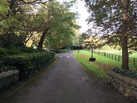
approach to Auburn House not only highlighted the design of the landscape, but also emphasised
the wealth and prestige of the owner.

Image 2: Approaching Auburn House from Malahide Road

Parkland Setting
The location and setting of the house historically appears to have been a pastoral parkland
landscape context, typical of the English landscape garden principles at that time. Reference to
the historic mapping indicates that Auburn was historically approached by a meandering drive
through woodland which brought visitors up to the house, providing only glimpse views along the
route and only fully revealing the house at the front forecourt, in order to achieve maximum drama
and impact. While the estate was not sufficiently large to allow for the grand gestures of other
large houses of that period such as Belcamp Hall located 6km south of Auburn, the estate lands
still contained similar features including woodland and a walled garden within a parkland setting.
It is likely that the front field contained a number of loose tree groupings to provide a pleasant
vista from the front of the house, framing the vista towards Malahide Castle. This view is
deliberately observed from the house only.
In addition, the lands to the immediate west of the house are indicated in the 1837 layout as
having pathways and were likely laid out as woodland walkways to allow the owners and visitors
to take pleasant walks close to the house. The combination of pastoral open lands and structured
woodland assisted in reinforcing the parkland character.

The Historical Landscape at Auburn House                                                     7
Issue 3

The philosophy behind the English landscape garden was Naturalism, favouring curved lines,
gentle slopes, lakes and woodlands, moving away from the strict formal geometric gardens of the
Baroque period. These gardens were designed to look natural and be a place for meditation and
relaxation.

Figure 3: historic map highlighting parkland setting

The Woodland
The woodland setting was both a functional and aesthetic feature in the landscape. The trees
served the aesthetic function of framing views from the house and creating a scenic backdrop to
the house. Aside from their visual qualities, Brownian landscapes also appealed to landowners
on commercial and practical levels. They also reflected changes to upper-class leisure in the 18th
century. Lighter guns enable sportsmen to shoot birds on the wing, so landscapes needed to
incorporate areas of cover where game such as pheasant could be reared. Given that Auburn is
a relatively small estate, game shooting may not have been possible.
The existing woodland around Auburn House varies in age and condition. The original woodland
is the most imposing element of the English landscape garden within the Auburn estate. The
original woodland would have comprised Oak, Beech Horse Chestnut, Sweet Chestnut and Lime
which are now over mature and in decline, with increasing losses over the last 20 years from
winter storms. This has resulted in the natural re-generation of primarily Ash and Sycamore
replacing the planted woodland and creating an increased proportion of the woodland today.
A small coniferous plantation of sitka spruce and lawson cypress is present north and south of
the house. These trees are c. 20 yrs old and appear to have been planted to replace a gap in the
existing woodland. They are historically incorrect and inappropriate to the location.

The Historical Landscape at Auburn House                                                     8
Issue 3
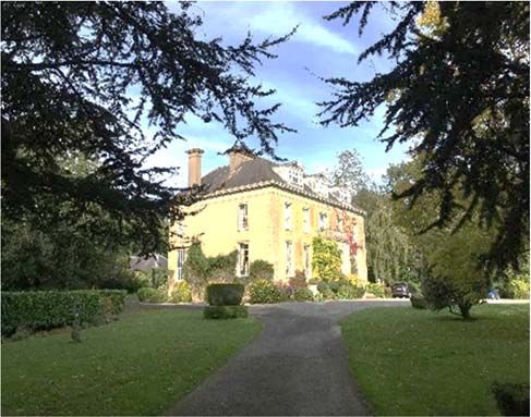
Image 3: Aerial view of southern part of the woodland   Image 4: Framed view of Auburn House from stone bridge

Waterways and ditches
Lakes formed an important component of the English gardens, most were man made but all
appeared to replicate natural forming waterbodies. However, Auburn does not contain a lake,
possibly due to the relative small size of the estate. Instead, an existing stream that flows through
the estate lands was utilised and designed to replicate a meandering water element within the
naturalistic landscape, that brings both beauty and sound to the estate. The stone bridge over
the stream adds to the picturesque quality of the stream and provides views of the water. Today
significant re-generated vegetation obscures views of the stream.
A number of ditches are located with the estate lands, which form field boundaries. These ditches
remain predominantly dry and are used as part of the estate drainage system during periods of
high rainfall. Today significant vegetation is located either side of the ditches.

Image 5: View of the stream from the stone bridge

The Historical Landscape at Auburn House                                                                   9
Issue 3

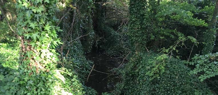
The Walled Garden
Walled gardens were a common feature of the historic stately houses of the past. The walled
gardens were once known as ‘the kitchen garden’ as vegetable and fruit trees were grown to
keep the family kitchen well stocked. The tall perimeter wall had a strong aesthetic value, but also
provided a very valuable function; to raise the temperature of the garden and provide a more
protective environment for the plants within. The walls would absorb the heat of the sun during
the day and release the heat slowly during the evening and through the night.
The walled garden largely remains intact, although the majority of the original space is not
included within the subject application. The remaining area which forms this application, is
approximately one third of the original and is located to the west of the walled garden. It is
enclosed with limestone coursed walls with no defined capping detail. To the north and west side
of this portion of the walled garden there is a wide drainage ditch that is bridged by a metal bridge
at its pedestrian access point to the north side. The garden has become overgrown with
significant numbers of re-generated trees.
The north and south corners of the west side wall of the walled garden are enlivened by the
insertion in the 19th century of corner towers. It is likely that the corner towers were added in 1845
when the house changed ownership to William Donnelly. Indeed, their castellated romanticism
owes more to the 19th century love of the gothic and medieval than to the late 18th century
adherence to the classical ideal.
A small pet cemetery with two headstones are also present within the garden. Pet cemeteries
were typical features of the Irish country house garden.
The eastern walled garden was renovated during the 1990’s with a glasshouse and a tennis court
incorporated along with a plantation of plum and pear trees.

Image 6: View of the orchard                    Image 7: Walled Garden OS six-inch map (1829, 1841)

Sculptural elements and recreational architecture
Another architectural feature of the English landscape garden came in the form of sculpture and
recreational architecture. Within the estate grounds, several sculptural and architectural elements
can be found including statues, stone vases as well as the corner towers within the walled garden.
The use of a ha-ha wall was also employed at Auburn, located north of the main house. The
purposes of the ha-ha was to give the viewer of the garden the illusion of an un-broken,
continuous rolling lawn, whilst providing a boundary for grazing livestock. It involved digging a

The Historical Landscape at Auburn House                                                              10
Issue 3
deep, dry ditch the inner side of which would be built up to the level of the surrounding turf with
either a dry-stone or brick wall.


Image 7: Lion statues on both sides of the drive        Image 8: Corner tower in the walled garden

3.0       Conservation and Mitigation Measures within the proposed development
The primary design philosophy for the proposed development is based on the principle of
retaining and enhancing the historic fabric of the Auburn estate lands and ensure its successful
integration within the proposed development.
The proposed development seeks to retain and restore the historic cultural landscape and setting
of Auburn House by retaining and enhancing the character of the English landscape garden,
allowing the original design principles define the character of the proposed development.
The Vista
Many of the landscape features within Auburn estate will be restored and enhanced. The lands
in front of Auburn House will be retained as public space to retain in part the vista towards
Malahide Demesne. Proposed courtyard type clusters forms the edge of the vista (north and
south) with housing units located along the eastern periphery of the open lands, allowing gentle
ground modelling in combination with parkland tree planting to be sensitively inserted between
the proposed buildings. A SuDs detention basin is located in the centre of the space. The scale
of the tree planting will be such as to provide an element of maturity in the landscape. The overall
subtle landscape treatment will allow the buildings to sit into the landscape to minimise the
change in the existing landscape character.
The Drive
The original drive and entrance walls and gates that provided access to Auburn House will be
retained through the provision of a dedicated pedestrian/cycle path along it’s length. This will
ensure the retention of the existing woodland either side of the drive. The existing character of
the drive will be retained and enhanced through the provision of replacement woodland tree
planting. A Woodland Management Plan will be prepared for the estate including the drive that
will provide detailed objectives and proposals for the short, medium and long term woodland
management.
The proposed vehicular traffic will be accommodated through the provision of a new access road
located east of the existing drive and woodland edge that allows for the retention of the existing
woodland belt at this location.

The Historical Landscape at Auburn House                                                                 11
Issue 3
A new vehicular entrance to the Auburn lands will be formed immediately south of the existing entrance in a location where few existing trees are present. The design of the entrance walls will respect the scale, form and character of the existing entrance. The new access road will quickly sweep northwards to avoid existing trees and cross the existing drive to avoid the existing woodland belt east of the existing drive. The access road will run perpendicular to the drive, cross the existing stream before sweeping north and westwards to provide access to the proposed buildings north of Auburn House. Parkland Setting Development is proposed within the existing parkland in the areas indicated on the site layout plan. These are contained on parts of the present lands which are less directly visible from Auburn House. The proposed development is also located primarily within the existing open fields with the exception of a proposed apartment block located within the existing coniferous plantation south of the house and a community building located within the walled garden. The open lands to the east of the house are retained in large part, while it is noted that development is proposed in two courtyard type clusters to the immediate north and south of the open lands in front of the house and also along the eastern periphery of the open lands. The open land provides space for gentle ground modelling in combination with parkland tree planting to be sensitively inserted between the proposed buildings. The scale of the tree planting will be such as to provide an element of maturity in the landscape. The overall subtle landscape treatment will allow the buildings to sit into the landscape to minimise the change in the existing landscape character. It is worth noting that the original design intent of the drive was to provide conceal and reveal views to create drama along its length as it approached the house. The stone bridge over the stream currently identifies a deliberate change in landscape character as the lands currently open up towards the parkland landscape and provide glimpse views of the house in the distance. The location of the proposed southerly courtyard cluster will restrict views of the house from the existing drive. Impacts: the character of the approach to the house along the drive is altered by the intervention of the southerly courtyard cluster and can be characterised as a negative impact. Development is proposed on the lands north of the original entrance driveway, formerly known as ‘Little Auburn’. The approach to Malahide along the Malahide Road is enclosed by the existing woodland belt within Malahide Demesne and the woodland located along the boundary of the subject site. This woodland is a distinguishing feature and contributes to the character of the area. It is intended that this woodland belt will be retained with the exception of trees highlighted in the tree survey that are in poor health/state of decline that necessitates their removal. The retention of the woodland belt is crucial in protecting the landscape character along the Malahide Road, as well assisting to mitigate the potential impact of the proposed buildings located behind the woodland belt. The tree belt will be further reinforced with new mature tree planting within the proposed parkland between the proposed development and the existing trees. A Woodland Management Plan will be prepared that will provide guidance on the future maintenance and re-planting of the woodland including the woodland belt fronting the Malahide Road. The Historical Landscape at Auburn House 12 Issue 3
The Woodland
A Tree Survey was undertaken during 2019 and 2020 by The Tree File and accompanies this
SHD planning application. The Tree Survey report summary identifies that some trees will be lost
due to the proposed development and related infrastructure. However, the significant woodland
blocks associated with the estate including the main woodland to the rear of the house and the
woodland belt associated with the drive and the Malahide Road boundary site be retained.
In its broadest terms, the Auburn tree population today exists as a deteriorating relic of a once
substantial and ‘grand design’ demesne planting. It appears that many of the larger and more
mature trees have been lost over recent decades. Additionally, and as illustrated by the tree
survey report, many of the trees that remain are becoming progressively isolated and exposed
and accordingly are becoming subject to mechanical failure and damage. Therefore a Woodland
Management Plan will be required to provide guidance and a strategy by which the site’s existing
and future tree population and woodland areas can be managed, maintained, restored and
improved in a sustainable manner to accommodate the requirements of the planning authority
and all stakeholders.
Impacts: the proposed retention of the woodland blocks associated with the estate is a positive
planning gain. However, the inclusion of a small apartment block located within the coniferous
plantation south of the house will alter the integrity and character of the woodland and the
approach to the house along the drive and can be characterised as a negative impact.
Waterways
Lakes formed an important component of the English gardens, most were man made but all
appeared to be natural forming basins. However, Auburn does not contain a lake, possibly due
to the relative small size of the estate. Instead an existing stream that runs through the estate
lands was utilised and was used a meandering water element within the naturalistic landscape,
that brings both beauty and sound to the estate. The stone bridge over the stream adds to the
picturesque quality of the stream and provided views of the water. Today significant re-generated
vegetation obscures views of the stream.
A number of ditches are located with the estate lands, which form field boundaries. These itches
remain predominantly dry but are used as part of the estate drainage system during periods of
high rainfall. Today significant vegetation is located either side of the ditches.
It is proposed that the stream will be retained within the proposed development as it forms an
important boundary as identified in the historical mapping and plays an important role in the
integration of the proposed development into the existing landscape setting.
A significant proportion of the existing vegetation along the banks of the stream will require
removal due to poor health/form, or to allow re-profiling of the ground levels to accommodate the
proposed roads/infrastructure, as identified in the arboriculturists report. Riparian planting will be
provided along the stream edge and comprise wildflower/pollinator friendly species and tree
planting to provide visual interest, amenity and enhance biodiversity within the proposed
development.
The Walled Garden
Traditionally, the walled garden was once known as the ‘kitchen garden’ as vegetable and fruit
trees were grown to keep the family kitchen well stocked, which was also the case at Auburn.
The walled garden largely remains intact, although the majority of the original space is not
included within the subject application.

The Historical Landscape at Auburn House                                                         13
Issue 3
The garden has become overgrown with re-generated scrub material including hazel, holly,
sycamore and ash. It is proposed to remove the re-generated material which did not form part of
the original design intent and replace it with orchard trees to re-create the original design. The
existing large plane tree located in the north-eastern corner of the garden will be retained and
enhanced through the provision of a quality lawn area providing an attractive passive amenity.
The small pet cemetery within the garden will also be retained.
The proposed community building within the walled garden is clearly a change of character to
this space. The garden is currently enclosed with limestone coursed walls and the proposed
development will require penetration and removal of part of the wall along the western elevation
to provide vehicular and pedestrian access to service the building. The provision of new stone
piers would assist in defining and mitigating the proposed openings.
Impacts: the character of the walled garden is altered by this intervention and can be
characterised as a negative impact.
Sculptural elements and recreational architecture
It is proposed to retain the existing sculpture and ha-ha within the estate lands.

4.0 Conclusion
The design intent of the proposed development is to ensure the protection of the natural and built
heritage through the repair, preservation and improvement of its historic fabric and setting. It is
acknowledged that the original expansive fields to the north and east of the house will be replaced
with housing and that development will occur within the walled garden and part of the existing
woodland. However, the reinstatement of the curtilage at ‘Little Auburn’ assists in re-instating
part of the original demesne, in combination with the elements of the lands that make up the
original landscape design principles including the woodland, walled garden and watercourse, will
both help preserve the historic identity of the lands and preserve Auburn House as a piece of
history for future generations.

The Historical Landscape at Auburn House                                                      14
Issue 3
The Historical Landscape at Auburn House   15
Issue 3
You can also read