Central Indiana April 2022 Climate Summary
←
→
Page content transcription
If your browser does not render page correctly, please read the page content below
Central Indiana
                         April 2022
                     Climate Summary
               Tied 55th Coolest on record at Indianapolis
              Tied 43rd Wettest on record at Indianapolis
              Tied 24th Snowiest on record at Indianapolis

Temperatures
April 2022 was rather cool, with most locations averaging 1 to 2.5 degrees below normal across
central Indiana. This included several ~3-day periods, about once every ~8 days, of very cool
conditions amid an otherwise consistently chilly pattern, with the only unseasonable warmth
confined to the month’s last full weekend. Daily temperatures at Indianapolis averaged 10 or
more degrees above normal only 2 times - the 23rd-24th; and averaged 10 or more degrees below
normal on 5 other days: 9th, 17th-19th, 26th. April 2022 continued the near- to below-normal
pattern also seen during April 2020 and April 2021. The upper-levels brought many passing
waves amid an overall zonal flow, except for occasional broad, deep troughs that favored the
north-central US; this pattern promoted considerably cloudy and cool weather, often among
approaching warm frontal zones.
April began as a deep storm system departed into southeastern Canada, allowing cold Canadian
high pressure to plunge into the Mid-West in its wake. Most locations recorded their lowest daily
maximum on the 1st¸ including 44F at both Indianapolis and Bloomington and 45F at Terre Haute,
while only 38F was reached at the Rockville (Parke Co.) COOP site and only 40F was managed at
both the Kokomo 3 WSW (Howard Co.) and New Castle 3 SW (Henry Co.) COOP sites. The
morning of the 2nd was the month’s coldest for most locales, with a hard freeze common across
the region, and readings as low as 23F at the Davis Purdue AG Center at Farmland 5 NNW
(Randolph Co.). The rest of the first week saw a slight moderation to near-normal levels.
On the 7th-9th, a deep, broad stacked low slowly crossed the Great Lakes, bringing persistent light
rainfall and a robust and chilly west-northwesterly flow. Highs ranged from the mid-40s to
around 50F, with the 8th only climbing to 42F at the Frankfort Disposal COOP station (Clinton Co.),
and only to 44F at Lafayette and places as far south as the Farmersburg TV-2 station (Sullivan
Co.), while the 9th’s max temps were as low as 42F in Rockville, with 44F observed at both Muncie and Castleton 2 S (Marion Co.). Daily low temperatures trended from near 40F to near 30F; the morning of the 10th was the coldest - Indianapolis dropped to 30F, while Rockville’s 25F was the lowest observation, with a hard freeze scattered through the rest of the region, and as far south as a 27F mark at the Oolitic Purdue Experimental Farm (Lawrence Co.). The month’s greatest warming then followed during the 10th’s daytime as a quickly-arriving upper ridge helped to boost temperatures into the 60s to around 70F: Terre Haute climbed from 28F to 69F (for a change of +41 degrees) in just over 10 hours, while the Shoals 8 S (Martin Co.) COOP station’s increase from 30F to 71F was also +41 degrees. Mild days followed on the 11th-13th as afternoon highs reached the mid 60s to low 70s for most locations: on the 12th Bloomington peaked at 73F, while it was 74F at the Seymour 1 WSW (Jackson Co.) CCOOP station, and Shoals 8 S reached 78F; on the 13th, Oolitic hit 77F and Indianapolis was 68F. The most unseasonable cold of April 2022 occurred on the 17th-19th as two areas of polar high pressure pushed across the Mid-West in quick succession, with the second ridge advancing as far as the southeastern US. Morning lows were in the upper 20s to mid-30s, while daytime highs only reached the 40s on the 18th, while 50s were common on the 17th and 19th. The 17th and 18th saw temperatures at or below freezing over the northern/eastern half of central Indiana, with Farmland 5 NNW dropping to 26F and 27F, respectively, while Kokomo 3 WSW and Tipton 5 SW (Tipton Co.) were 27F on both mornings. The morning of the 19th brought a more widespread, yet milder freeze, as readings of 30F to 32F were common across the entire region, with 27F in Rockville, while Indianapolis dropped to 31F for its only freeze of the week. Maximum temperatures on the 18th were as low as 39F at both Kokomo 3 WSW and New Castle 3 SW, while Lafayette and Muncie only topped out at 42F; meanwhile 51F was reached at both the Southwest Purdue AG Center at Vincennes 5 NE (Knox Co.) and Shakamak State Park (Sullivan Co.). Very warm conditions then graced central Indiana on the 23rd-24th courtesy of robust south- southwesterly flow between the remnant surface high along the Atlantic coast and a late-winter storm system deepening over the northern Plains. Mid-80s were the rule on the 23rd, with 86F reported across all corners of the realm - from Shelbyville and Indianapolis - Eagle Creek to Shoals 8 S and Tipton 5 SW, while lowest maximums were found at a few sites in Clinton and Tippecanoe Counties that only reached 79F. Castleton 2 S’ 85F was the “highest April max since 2002”; as was the case for Indianapolis’ 84F, however, Indy’s April maximum historically averages 81F, with the month having topped out in the 79-83F range in each of the past 9 years (2013-2021). The 23rd also had the mildest overnight of the month, as readings only dropped into the 60s, with the highest minimum observed at Shoals 8 S (70F), while Shelbyville and Muncie only dropped to 67F, and Indianapolis observed 63F. The 24th’s max temps were not as warm yet still well above normal, led by 84F at several sites, including Shelbyville and Washington 1 W (Daviess Co.), while Indianapolis peaked at 81F. A cold frontal passage during the overnight of the 24th started a quick transition to a couple more days of well below normal temperatures. Another polar mass of high pressure crossed the Great Lakes during the 26th-28th, with central Indiana catching the milder, southern periphery of this chill. Morning lows on the 26th and 27th dropped into the 30s, although sub-freezing temperatures were isolated; lowest readings being
29F on the 27th (at Farmland 5 NNW and Kokomo 3 WSW), and 30F on the 28th (at Tipton 5 SW
and Crawfordsville 6 SE (Montgomery Co.)). The 26th featured the coldest afternoon of the week,
with readings ranging from 50F at Farmland 5 NNW to 64F at Elnora (Daviess Co.).

April 2022’s slightly below normal temperatures continued the trend since April 2020’s slightly
below normal and April 2021’s near normal readings. Yet, April 2022 was in contrast to the
noticeably mild March 2022.

                                April 2022        April 2022          Highest           Lowest
            Site              Average Temp       Dep from Nml       Temperature      Temperature
Indianapolis Int’l Airport        51.5                -2.2           84 on 23rd        29 on 2nd
Lafayette                         49.6                -1.5           83 on 23rd      28 on 2nd, 10th
Muncie                            51.4                -2.2           85 on 23rd        24 on 2nd
Terre Haute                       52.8                -1.2           84 on 23rd        26 on 2nd
Bloomington                       52.6                -1.7           85 on 23rd        26 on 2nd
Shelbyville                       53.7                -0.8           86 on 23rd        30 on 10th
Indianapolis Eagle Creek          51.9                -1.7           86 on 23rd        27 on 2nd

At Indianapolis, April 2022’s daily average temperatures were above normal on 12 days and
below normal on 18 days. It was the (tied) 55th coolest April for the Indianapolis Area since
weather records began in 1871, placing it in the 36th percentile of all recorded Aprils.

Precipitation
Following the release of the new 30-year climatological normals (1991-2020), April is now
typically the fourth-wettest month across most of central Indiana, normally totaling significantly
more precipitation than March, yet less than May, June or July. Exceptions to this pattern are
found across the region’s southern counties where April ties May as the year’s climatologically
rainiest month at Terre Haute, while at Bloomington April falls in second behind June, and at
Shelbyville it is normally the third-rainiest month after May and June. The previous 30-yr normals
(1981-2010) had placed April as only the 4th-wettest at all seven 1st-order sites.
The region’s typical north-south precipitation gradient is normally present in April, ranging from
just under 4” across the far northern counties to just over 5” along far southern zones. Although
this difference is proportionally less than that normally found in the January-March period – this
follows the trend into more uniform precipitation across central Indiana through May-August.
Despite measurable rain falling on 17 to 19 days, April 2022’s totals were generally about an inch
below these normals; although locations through several central counties finished the month
with near to slightly above normal precipitation totals. 4.42” fell at Indianapolis International Airport, which was essentially at normal. Despite monthly totals generally modest compared to normals, April 2022 was the wettest April of the last three years. Minor river flooding carried over from March 2022 on the Wabash River from Montezuma down to Riverton. Flooding ended on the night of the 4th at Montezuma and Terre Haute; and despite light rains finally ended at Riverton early on the 6th, after over two weeks of flooding at this site. Following several days near bankfull conditions, Vincennes’ river stage teetered at or just into minor flood from pre-dawn on the 3rd to the morning of the 5th. Daily widespread light rains fell over central Indiana from the 5th through early on the 9th. 1-day totals were as high as 0.65” through dawn on the 6th at Clay City (Clay Co.), and 0.59” through dawn on the 7th at Hymera (Sullivan Co.); although reported 4-day totals were no greater than the isolated 0.90-0.98” reported across Sullivan, Owen, and Tippecanoe Counties. The 11th found more widespread light to moderate rainfall, around a lone heavier observation of 1.06” at the Bowling Green 1 W COOP site. The generally damp mid-month pattern finally produced more appreciable rains on the 13th, with 0.50-1.70” common across the region, an 1.90” observation near Mooresville (Morgan Co.), and reports near/above 1.50” common across Lawrence, Martin and Monroe Counties. Following this more impressive rainfall, a few site specific river sites flooded on the 14th from pre-dawn to afternoon hours, namely, the Mississinewa River at Ridgeville, Flatrock River at Raleigh, and Beaver Creek at Shoals. Main stem river flooding soon followed on most of the lower White River: Elliston, Edwardsport, and Petersburg entered flood stage on the 14th, with Hazleton following on the 15th. The associated crest flowed from Elliston at dawn on the 15th down to Hazleton by pre-dawn on the 18th. Minor flooding ended at Elliston on the morning of the 16th¸ and at Edwardsport on the 18th, with points along southern Knox County ending ~6 days in flood on the 20th-21st. Isolated flooding was also observed along other main stem rivers: the East Fork of the White at Seymour flooded from the 14th-16th, while the Wabash at Montezuma flirted with the minor flood threshold for ~6 hours early on the 16th. Several more days of widespread light rainfall occurred within the 17th-20th, with no 1-day readings exceeding ~0.50”; the greatest 4-day totals of 0.60-0.90” were over south-central zones, especially Monroe and Lawrence Counties. April’s last week then started with a broad swath of moderate to heavy rainfall on the 24th over all but southeastern counties; with the greatest observations along a narrow axis from 2.93” at Vincennes 5 NE, through 1.93” just south of Ellettsville (Monroe Co.), to 1.43” in Greenwood (Johnson Co.). Following additional light to moderate rain on the 25th, numerous 2-day totals of 0.80-2.00” were seen near and between the I-70 and I-69 corridors, with 3.11” at Vincennes 5 NE, as well as 2.21” northeast of Bloomfield (Greene Co.). Isolated flooding followed, with Youngs Creek at Amity reaching minor flood from the afternoon of the 25th to dawn on the 26th¸ while the White River at Edwardsport spent 2.5 days in flood over the 26th-28th. The month closed with one final rainy day on the 30th as scattered afternoon showers led to several rounds of evening thunderstorms, which made for the month’s greatest 24-hr totals over northern portions of the Indianapolis metro and points northeastward: 2.16” near Sheridan
(Hamilton Co.), 2.14” in Williams Creek (Marion Co.), and 2.05” just north of Anthony (Delaware
Co.).
Late winter light snows and/or mixed precipitation occurred on several days, when promoted by
nocturnal timing, and with organized accumulating snowfall generally confined to the Interstate
74 corridor and north. Rain had just changed to snow as the month began early on the 1st. As
noted by Bob McLain at Castleton 2 S, “snow melted as it landed”, with only a very thin coating
reported across many northern and central counties, and isolated ~½” amounts in the Lafayette
and Carmel areas. Very early on the 9th, rain mixed with or changed to various frozen
precipitation types, including sleet, graupel, and eventually snow, dropping a dusting from
Lafayette to Muncie, with as much as 0.6” at Kokomo 3 WSW, before tapering off during the
morning. The month’s greatest snowfall came on the 18th from briefly-potent early morning
snow showers, which brought a broad patch of 1-2” from the Lafayette area to northeast
counties, while embedded narrow, heavier bands lead to reports of 2.9” near New Ross (Boone
Co.) and 2.7” at New Castle 3 SW. A mixture of rain at the onset limited snowfall south of
Interstate 70 to generally a light coating; amid this north-south gradient, Indianapolis officially
observed 1.0” (which was all of Indy’s measureable snowfall for April).
In summary, precipitation was frequent, but nevertheless for most locations sub-normal, with
these generally slight deficiencies due to lack of stronger thunderstorms. While April normally
sees 11-13 days with measurable rain, this was surpassed by 8 days at Terre Haute and 5-6 days
elsewhere. However, there are normally ~8 days with 0.10”+ of rain -- Terre Haute and
Bloomington both totaled 11, while the five other 1st-order sites were overall near this normal;
thus the above normal frequency of days with measureable rain was led by very light rainfalls.
April 2022’s generally slightly below normal precipitation continued the pattern from April 2021’s
rather dry conditions, while countering the trend from March 2022’s plentiful totals. The year-
to-date total at Indianapolis rose to 14.80”, a surplus of 1.22” above normal.
Site April 2022 April 2022 Wettest Day Longest Dry Stretch
Precipitation Dep from Nml
Indianapolis Intl AP 4.42 +0.02 1.04 on 13th 2 days, 22-23rd, 26-27th
Lafayette (*) 2.01INC M M on 13th 2 days, 16-17th, 26-27th
Muncie 2.99 −0.90 0.98 on 25th 2 days, 26-27th
Terre Haute 3.34 −1.37 0.77 on 13th 2 days, 3-4th, 26-27th
Bloomington 4.71 −0.23 1.41 on 25th 2 days, 3-4th, 26-27th
Shelbyville 3.42 −1.12 1.34 on 25th 2 days, 26-27th
Indy - Eagle Creek 4.54 +0.46 1.16 on 30th 2 days, 26-27th
(*) Lafayette’s observed precipitation was incomplete
April 2022 was the (tied) 43rd wettest in the Indianapolis Area since weather records began in 1871,
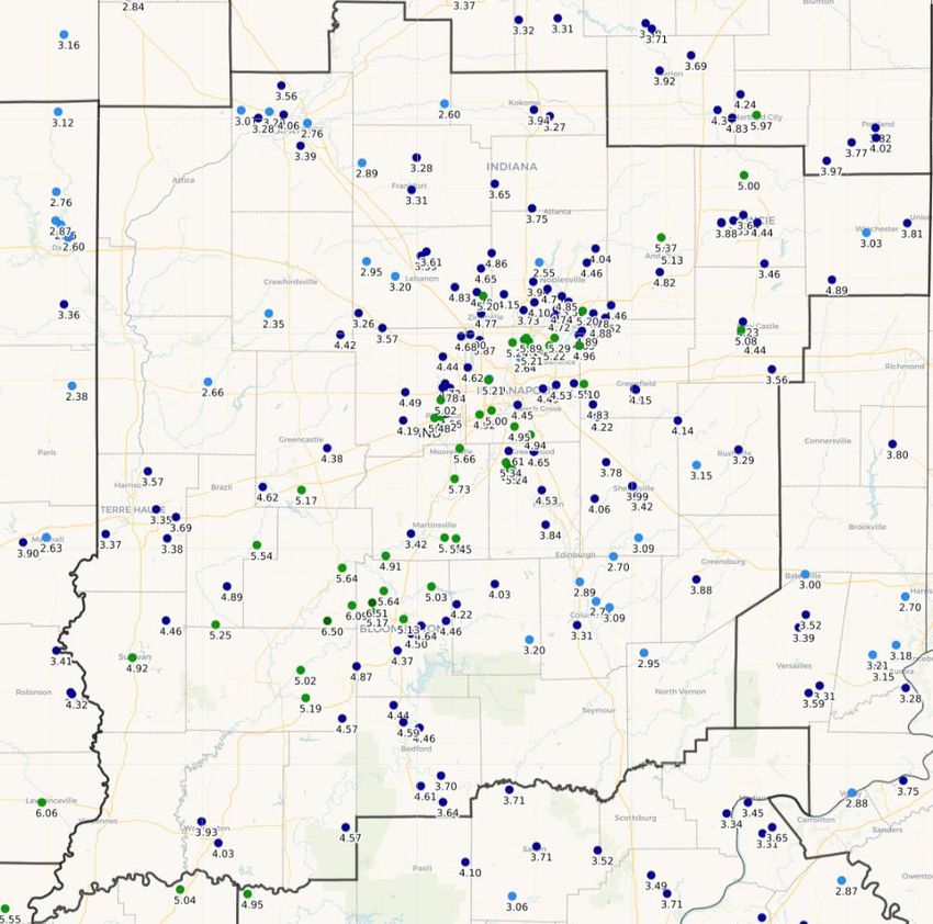
placing it in the 72nd percentile of all recorded Aprils.April 2022 Total Precipitation, Through the Morning of 5/1/2022
As Reported By Central Indiana CoCoRaHS Observers
For the period 700 AM EDT 4/1/2022 -to- 700 AM EDT 5/1/2022. Data is unofficial.
Totals were greatest (4.00-6.50”) along and near the I-69 corridor. Minimum values (2.00-3.00”) fell over
several northwest and a few southeast counties. Most of the region was at least slightly below normal.Severe Weather
The several days of severe reports included damaging winds impacting several counties on April
13th, as well as isolated events on the 12th, 15th, 23rd.
On the 13th, moist lower levels combined with a deep trough over the Mid-West to promote a
line of strong storms over southern central Indiana by the early evening. These cells further
organized into a squall line whose bowing segments lead to damaging straight line winds,
including significant damage to both boat docks on Lake Monroe (Monroe Co.), and the Country
Squire Lakes trailer park (Jennings Co.). An associated region of broad rotation eventually lead
to the squall line spawning a brief EF-0 tornado west of Millhousen (Decatur Co.), with the only
damage being to a lean-to roof and wall on a farm outbuilding, while a small horse trailer was
picked up and thrown northward.
On the 12th¸ elevated late morning thunderstorms produced a gust of 59 mph at Indianapolis Int’l
Airport. The 15th found weak early evening showers produce briefly strong wind gusts courtesy
of very dry, and relatively warm, low-levels; including a gust of 61 mph at the Delaware County
Airport. Lastly, April 23rd’s breezy, non-severe-magnitude winds unfortunately downed a large
dead tree in the Indian Oaks Campground (Owen Co.), killing two children.
For info on severe weather in other areas during April, visit the Storm Prediction Center
“Severe Weather Event Summaries” website at spc.noaa.gov/climo/online
Miscellaneous – Winds, Thunder, Fog & More
April 2022 found occasional strong and a couple severe wind gusts across the seven 1st-order
airports from the 11th to the 24th. Indianapolis observed 59 mph from the south-southwest on
the 11th (see severe section above, then Muncie recorded 61 mph from the west on the 15th.
Also noteworthy was Lafayette’s gust to 50 mph on the 14th. Peak gusts of 45-50 mph were
common on the 15th, as were gusts as high as 40-48 mph on both the 20th and 24th. Yet most
notable were the 26 days at Indianapolis when the wind gusted to 25+ mph – this was the
greatest frequency of any month at Indianapolis since at least July 2018, and well above the
second highest count of these last ~4 years, which was only 22 days in March 2021.
Fog was frequent amid the rather damp conditions, ranging from 12 days to as many as 15 days
at Indianapolis and Terre Haute. All seven 1st-order airports observed fog on the 5th, 6th, 9th, 13th,
and 21st, with fog also common on the 1st, 8th, 11th, 12th, 18th, 22nd, 24th, 25th, and 30th. Dense
fog was rare, only being reported on the 12th at Muncie and Indianapolis – Eagle Creek, on the
13th at Bloomington and on the 22nd at Shelbyville.Thunder frequency rather modest for mid-spring, ranging from 2 days at Muncie to 5 days at
Bloomington, with most 1st-order sites reporting thunder on 4 days. Thunder was common on
the 11th, 13th, 24th and 25th, and all 1st-order sites observed thunder on the 30th.
While not as common as March 2022, the relative humidity did reach very low levels during the
early to mid afternoon of the 15th, including 13% at Muncie, 16% at Shelbyville, and 17% at
Indianapolis. The associated dry lower levels of the atmosphere contributed to the rather potent
wind gusts produced by otherwise weak rain showers early that evening (see severe section
above).
Central Indiana’s many COOP observers also provided several noteworthy remarks with their
daily reports. Spencer (Owen Co.) observed frost on the mornings of both the 2nd and 6th. On
the 13th, the Oolitic Purdue Farm (Lawrence Co.) reported “a few pieces of small, pea sized hail
about 7 p.m.” The morning of the 27th found frost reported at Tipton 5 SW as well as “patches
of light frost” at Castleton 2 S. Lebanon 6 W (Boone Co.) remarked “breezy” or “windy” on 16
days, including the 8th-10th and 15th-20th. Lastly, Bob McLain noted Castleton 2 S’s barometer
readings for the month ranged from 29.53” (6th) to 30.41” (22nd).
May 2022 Outlook
The official outlook for May 2022 from the Climate Prediction Center indicates equal chances of
above, below, or near normal temperatures for central Indiana. The normal May temperature
for Indianapolis is 62.7 degrees.
The outlook also indicates equal chances of above, below, or near normal precipitation for the
region. The normal May precipitation at Indianapolis is 4.75”.
Data prepared by the Indianapolis Weather Forecast Office’s State Climate Team
Questions should be referred to nws.indianapolis@noaa.govYou can also read