Channel Law Group, LLP - Los Angeles City Clerk
←
→
Page content transcription
If your browser does not render page correctly, please read the page content below
Channel Law Group, LLP
                                                  8383 Wilshire Blvd.
                                                       Suite 750
                                                Beverly Hills, CA 90211

                                                Phone: (310) 347-0050
                                                 Fax: (323) 723-3960
                                               www.channellawgroup.com

JULIAN K. QUATTLEBAUM, III                                                          Writer’s Direct Line: (310) 982-1760
JAMIE T. HALL *                                                                        jamie.hall@channellawgroup.com
CHARLES J. McLURKIN

*ALSO Admitted in Texas

March 16, 2021

VIA ELECTRONIC MAIL

City of Los Angeles
200 N. Spring Street
Los Angeles, CA 90012

         Re: Supplemental Appeal Justification Letter for the MND for VTT-74891-1A,
         ENV-2017-1706-MND; 20920 – 20970 West Warner Center Lane; 20935 – 21051
         West Warner Center Lane; 20931 – 21041 West Burbank Boulevard; CF 21-0134

Honorable Members of the Los Angeles City Council:

         This firm represents Jeff Bornstein (“Appellant”). On or about January 13, 2020, the City
Planning Commission (“Commission” or “CPC”) issued a Letter of Determination1 (LOD) for
the mixed-use development project located at 20920 – 20970 West Warner Center Lane, 20935 –
21051 West Warner Center Lane and 20931 – 21041 West Burbank Boulevard (“Project”). The
Commission also adopted a Mitigated Negative Declaration (MND) as the environmental
document for the Project under the California Environmental Quality Act (“CEQA”). That MND
is entitled the: De Soto/Burbank Master Plan Project Draft Tiered Initial Study/Mitigated
Negative Declaration.2
1
  The LOD is available at: https://clkrep.lacity.org/onlinedocs/2021/21-0134_rpt_CPC_01-29-2021.pdf
The Council File is available at:
https://cityclerk.lacity.org/lacityclerkconnect/index.cfm?fa=ccfi.viewrecord&cfnumber=21-0134
2
  The Public Notice for the MND is Available at: https://planning.lacity.org/development-services/negative-
declaration-public-notices
The MND and the MND Technical Appendices are available at:
https://planning.lacity.org/odocument/a6156e25-5796-4bf5-81ac-571faed3f976/ENV-2017-1706.pdf
https://planning.lacity.org/odocument/a6286b5a-6082-4ca6-8a95-2e3ea05d84bb/ENV-2017-1706-A.pdf
https://planning.lacity.org/odocument/0a54ef3b-766d-4959-894d-740ec8b84bbc/ENV-2017-1706-B.pdf
https://planning.lacity.org/odocument/b691de28-9c55-4e6f-b509-872911860012/ENV-2017-1706-C.pdf
https://planning.lacity.org/odocument/22e80db4-dd85-4e30-8e06-fb2c2e54661c/ENV-2017-1706-D.pdf
https://planning.lacity.org/odocument/09368a2d-0731-4f61-9511-347594727d42/ENV-2017-1706-E.pdf
https://planning.lacity.org/odocument/d7d4f6e5-37b4-4a9b-8f87-2ced06e693c4/ENV-2017-1706-F.pdf
https://planning.lacity.org/odocument/97e29f16-d82c-4b4e-8bf2-0c9376e1de56/ENV-2017-1706-G.pdf
https://planning.lacity.org/odocument/a58de2b6-ce69-4eb2-b217-53d6f9e2c177/ENV-2017-1706-H.pdf
The City has prepared a Mitigated Negative Declaration for this large-scale Master Plan
project and has tiered that MND off an eight-year-old EIR for Warner Center 2035 (WC2035)
Plan area. In so doing the City has failed to address whether there are changes in circumstances
or new information that has become available since the preparation of the WC2035 EIR3, that
would result in new or more severe impacts from this proposed project and the Warner Center
2035 Plan. The City has tiered off the EIR for the WC2035 Plan despite the fact that the
proposed project would be built in eight phases and would not be completed until 2035 and
should thus itself be the subject of a Program EIR.

       This letter provides additional justification for why the MND for the project is inadequate
and an Environmental Impact Report (EIR) is required. It is organized as follows:

        I.      The Proposed Project
        II.     Changes in Circumstance and New Information That Has Become Known Since
                Adoption of the WC2035 FEIR Necessitate Preparation of a Subsequent EIR For
                the Warner Center 2035 Plan
        III.    Why the Proposed Project Is Not Eligible for an MND
        IV.     The Proposed Project Would Result in Significant Impacts
        V.      Conclusion

I.      THE PROPOSED PROJECT

       According to page 1 of the MND for the project, the proposed project is described as
follows:

                The Applicant proposes to develop the Project, which would be developed
                on an approximately 24.4-acre site located in the northwest quadrant of the
                intersection of De Soto Avenue and Burbank Boulevard (Project Site), in
                the Woodland Hills community of the City of Los Angeles (City). The
                Project Site is currently improved with a contemporary corporate office
                park (known as Warner Center Corporate Park), consisting of 12 low-rise
                commercial structures (Existing Buildings), each on a distinct parcel,
                ranging in height from one to three stories, supported by surrounding
                surface parking lots. The Existing Buildings include approximately
                340,339 square feet of floor area.

                The Project is located within the Commerce District of the Warner Center
                2035 (WC2035) Plan area and includes the phased demolition of the
                Existing Buildings and other improvements and the phased construction of
                a mixed-use development consisting of ten new buildings (New

https://planning.lacity.org/odocument/ad31d928-4da7-4f8a-83c1-002b76dae04d/ENV-2017-1706-I.pdf
https://planning.lacity.org/odocument/29cd62b1-4856-45ab-8359-85c6664e802d/ENV-2017-1706-J.pdf
https://planning.lacity.org/odocument/e8189fb6-b21c-4a03-a179-4d03ff81152b/ENV-2017-1706-K.pdf
https://planning.lacity.org/odocument/e1984daa-cb23-485e-9577-79291921a3f4/ENV-2017-1706-L.pdf
https://planning.lacity.org/odocument/82c9b25c-8e8f-4465-9660-4d4fa7edf48e/ENV-2017-1706-M.pdf
https://planning.lacity.org/odocument/8f46d329-b44b-4faa-9c2d-19c290b12a1c/ENV-2017-1706-N.pdf
3
  WC2035 DEIR Available at: https://planning.lacity.org/eir/WarnerCntrRegionalCore/DEIR/TOC_WarnerCnt.htm

                                                    2
Buildings), varying in height from approximately 35 feet (two stories) to
               350 feet (24 stories) in height. The Project would be constructed in eight
               phases and includes a total of approximately 2,634,268 square feet of floor
               area, with approximately 1,175,513 square feet of residential floor area
               (approximately 45 percent of the total floor area) and approximately
               1,458,755 square feet of non-residential floor area, consisting of office,
               retail and hotel uses (approximately 55 percent of the total floor area). The
               Project’s residential uses consist of approximately 1,009 multi-family
               units, including 841 apartment units (approximately 53 of which will be
               Work-Live Units, as defined in Section 4 of the WC2035 Plan) and
               approximately 168 condominium units (approximately 15 of which will be
               Work-Live Units). The Project’s non-residential uses include
               approximately 1,140,746 square feet of office space, approximately 7,731
               square feet of ground-floor restaurant space, approximately 15,741 square
               feet of ground-floor retail space, approximately 35,311 square feet of
               ground-floor restaurant and/or retail space, approximately 26,762 square
               feet of ground-floor office and/or retail space, approximately 4,068 square
               feet of community space, and an approximately 157,535 square-foot hotel
               with 228 hotel rooms. The overall floor area ratio (FAR) for the Project is
               2.52:1.

               Project parking would be provided within subterranean and podium levels
               beneath and within nine of the ten New Buildings. No stand-alone parking
               structures are proposed. Upon Project completion, onsite parking
               structures would provide 1,627 residential spaces and 3,921 non-
               residential spaces, for a total of 5,548 parking spaces. The Project also
               includes 870 long-term bicycle parking spaces and 264short-term bicycle
               spaces, for a total of 1,134 bicycle parking spaces. In addition, a minimum
               of 280 parking spaces for motorcycles/scooters will be included as part of
               the Project.

               The Project would be accessible from both Burbank Boulevard to the
               south and De Soto Avenue to the east. Vehicle access to the parking
               structures would be provided by an updated internal roadway network.
               Primary access through the Project Site would be provided by Warner
               Center Lane, which is a private street that would be reconfigured on a
               phased basis as part of the Project and qualifies as a “New Street” under
               the WC2035 Plan. Warner Center Lane would connect to two driveways –
               Commerce Drive to the west and Town Center Drive to the north. The
               internal circulation system also includes Adler Drive, a third driveway that
               would be directly accessible from Burbank Boulevard and Commerce
               Drive.

        The proposed project is thus a very large-scale phased project. Phased construction is
assumed to begin in 2021/2022 and would not be completed until 2035. Given the magnitude of
construction detailed for each of the phases, it is unlikely that development will occur within the
limits of the phasing plan as described.

                                                 3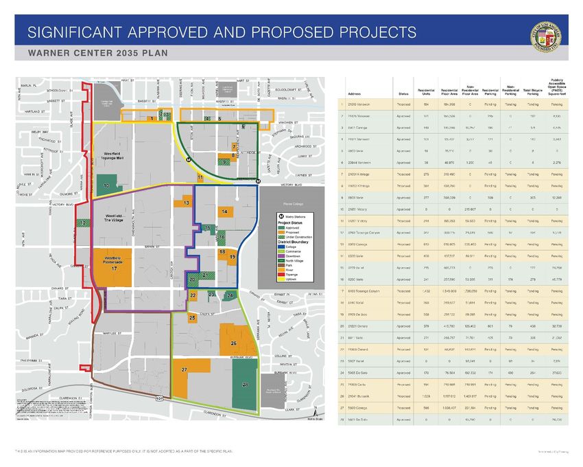
I.a.     Proposed Project Is A Multi-Phased Project

       As described in the Letter of Determination for the proposed project, the proposed project
is a multi-phased project, which would be developed in eight phases, with the last of the eight
phases completed in 2035:4

                i.   Phase 1: On Lot 1 per VTT-74891, 430,138 square feet of Residential
                     Floor Area, consisting of a maximum of 403 dwelling units including
                     42,781 square feet divided between 48 Work-Live units. The Phase 1
                     Project also includes approximately 61,456 square feet of Non-
                     Residential Floor Area which includes 49,017 square feet divided
                     between 48 Work-Live units, and 12,439 square feet of commercial
                     space divided between 3 commercial units. The Phase 1 Project
                     includes seven (7) above-grade levels of parking, a maximum of 605
                     new vehicle parking spaces inclusive of 17 new surface parking
                     spaces, 188 new long-term bicycle parking spaces, and 31 new short-
                     term bicycle parking spaces. The phase is proposed to be completed in
                     2022.

               ii.   Phase 2: On Lot 2 per VTT-74891, 223,892 square feet of Residential
                     Floor Area, consisting of a maximum of 204 dwelling units including
                     5,804 square feet divided between five (5) Work-Live units. The Phase
                     2 Project also includes approximately 8,904 square feet of Non-
                     Residential Floor Area which includes 5,639 square feet divided
                     between five (5) Work-Live units, 3,265 square feet of commercial
                     space in one (1) commercial unit, 2,000 square feet of lobby and
                     leasing office floor area, and 12,877 square feet of indoor residential
                     amenities spaces. The Phase 2 Project includes three (3) levels of
                     parking, one (1) of which is subterranean, a maximum of 321 new
                     vehicle parking spaces inclusive of three (3) new street parking spaces,
                     128 new long-term bicycle parking spaces, and 16 new short-term
                     bicycle parking spaces. The phase is proposed to be completed in
                     2023.

              iii.   Phase 3: On Lot 8 per VTT-74891, two (2) new, 15-story, commercial
                     buildings identified as Building 8 and Building 9, with a total 476,158
                     square feet in Non-Residential Floor Area. Building 8 is 243 feet in
                     height, and consists of approximately 241,574 square feet of Non-
                     Residential Floor Area, which includes 4,864 square feet of
                     commercial area in three (3) units at the ground level, 2,313 square
                     feet of office support area at the ground level, and 234,397 square feet
                     of office space. Building 9 is 239 feet in height, and consists of
                     approximately 234,584 square feet of Non- Residential Floor Area,
                     which includes 10,028 square feet of commercial area in two (2) units
                     at the ground level, 2,491 square feet of office support area at the
                     ground level, and 222,065 square feet of office space. The Phase 3
                     Project also includes eight (8) levels of parking in each building, two

4
    Letter of Determination, pages C-1 to C-3.

                                                   4
(2) of which are subterranean, a maximum of 1,427 new vehicle
       parking spaces, 100 new long-term bicycle parking spaces, and 56 new
       short-term bicycle parking spaces. The phase is proposed to be
       completed in 2024.

iv.    Phase 4: On Lot 6 per VTT-74891, one (1) new, seven- (7) story,
       commercial building, with a total 162,001 square feet in Non-
       Residential Floor Area. The Phase 4 Project includes 4,466 square feet
       of commercial area at the ground level and a maximum of 228 hotel
       units. The Phase 4 Project also includes two (2) levels of parking, one
       (1) of which is subterranean, a maximum of 195 new vehicle parking
       spaces inclusive of two (2) new street parking spaces, 30 new long-
       term bicycle parking spaces, and 26 new short-term bicycle parking
       spaces. The phase is proposed to be completed in 2029.

 v.    Phase 5: On Lot 5 per VTT-74891, 269,556 square feet of Residential
       Floor Area, consisting of a maximum of 168 dwelling units including
       16,205 square feet divided between 15 Work-Live units. The Phase 5
       Project also includes approximately 25,138 square feet of Non-
       Residential Floor Area which includes 16,205 square feet divided
       between 15 Work-Live units, and 8,933 square feet of commercial
       space in two (2) commercial units, 2,704 square feet of lobby and
       leasing office floor area, and 10,699 square feet of indoor residential
       amenities spaces. The Phase 5 Project includes three (3) levels of
       parking, one (1) of which is subterranean, a maximum of 412 new
       vehicle parking spaces inclusive of nine (9) new street parking spaces,
       118 new long-term bicycle parking spaces, and 17 new short-term
       bicycle parking spaces. The phase is proposed to be completed in
       2031.

vi.    Phase 6: On Lot 3 per VTT-74891, 251,927 square feet of Residential
       Floor Area, with a maximum of 234 dwelling units. The Phase 6
       Project also includes approximately 5,100 square feet of Non-
       Residential Floor Area which includes 5,100 square feet of
       commercial space in one (1) commercial unit. The Phase 6 Project
       includes three (3) levels of parking, one (1) of which is subterranean, a
       maximum of 403 new vehicle parking spaces inclusive of three (3)
       new street parking spaces, 138 new long-term bicycle parking spaces,
       and 17 new short-term bicycle parking spaces. The phase is proposed
       to be completed in 2031.

vii.   Phase 7: On Lot 7 per VTT-74891, one (1) new, 15-story, commercial
       building, with a total 262,222 square feet of Non-Residential Floor
       Area. The Phase 7 Project includes 11,870 square feet of commercial
       area in two (2) units at the ground level, 3,853 square feet of office
       support area at the ground level, and 246,499 square feet of office
       space including the ground floor lobby. The Phase 7 Project also
       includes ten (10) levels of parking, three (3) of which are subterranean,
       a maximum of 801 new vehicle parking spaces with no new street

                                     5
parking spaces included, 58 new long-term bicycle parking spaces, and
32 new short-term bicycle parking spaces. The phase is proposed to be
completed in 2033.
viii. Phase 8: On Lot 4 per VTT-74891, two (2) new commercial buildings
identified as Building 4 and Building 4a, with a total 457,776 square
feet in Non-Residential Floor Area. Building 4a is two (2)-story
building 35 feet in height, and consists of approximately 8,010 square
feet of Non-Residential Floor Area, which includes 3,942 square feet
of commercial area in one (1) units at the ground level, and 4,068
square feet of community space. Building 4 is a 24-story tower 350
feet in height, and consists of approximately 449,766 square feet of
Non-Residential Floor Area, which includes 20,638 square feet of
commercial area in five (5) units at the ground level, 8,077 square feet
of office support area at the ground level, and 421,051 square feet of
office space including the ground floor lobby area. The Phase 8 Project
also includes ten (10) levels of parking located in Building 4, two (2)
of which are subterranean, a maximum of 1,384 new vehicle parking
spaces inclusive of 11 new street parking spaces, 106 new long-term
bicycle parking spaces, and 69 new short-term bicycle parking spaces.
The phase is proposed to be completed in 2035.
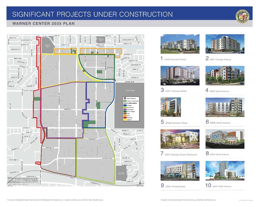
I.b. The Proposed Project Is Located In Close Proximity To Important Public Facilities
It should be noted that the proposed project is located in the immediate vicinity of several
important public facilities. The Kaiser Permanente Woodland Hills Medical Center abuts the site
to the south as does Los Angeles Fire Department Station 84. The West Valley California
Highway Patrol Station abuts the site to the north. In addition, the Woodland Hills Academy
Middle School, which is a school in the Los Angeles Unified School District, is located less than
550 feet to the southwest of the project site. All of these important facilities have the potential to
be impacted the project’s multi-phased construction. The potential for impacts to these facilities
has not been adequately addressed the MND for the proposed project.
I.c. The MND For the Project Is Tiered Off An 8-Year-Old EIR
The proposed project is located within the Warner Center 2035 (WC2035) Plan area.
The WC2035 Plan became effective December 25, 2013. An EIR for WC2035 was prepared.
The Final Environmental Impact Report for the WC2035 Plan (ENV-2008-3471-EIR; SCH No.
1990011055 was certified by the Los Angeles City Council on October 23, 2013 (WC2035 Plan
FEIR) (Council File No. 13- 0197).5 The MND for the proposed project is inappropriately tiered
off of this outdated 8-year-old FEIR.
5
EIR No. ENV-2008-3471-EIR, CPC 2008-3470-SP-GPA-ZC-SUD State Clearinghouse No.1990011055 Available
at: https://planning.lacity.org/eir/WarnerCntrRegionalCore/WarnerCntr_coverpg.htm
6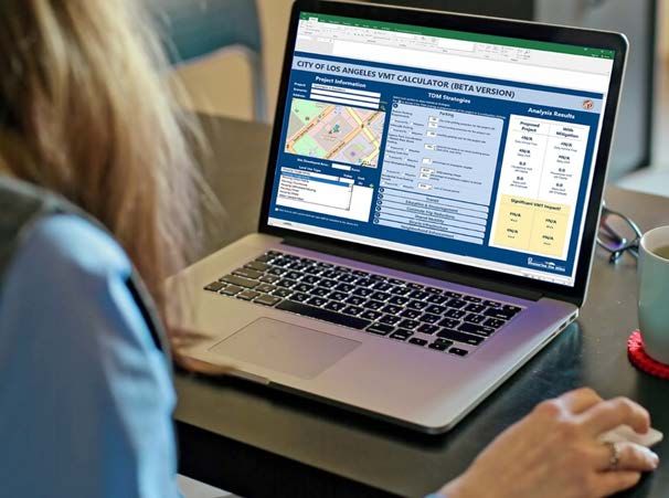
II.    CHANGES IN CIRCUMSTANCE AND NEW INFORMATION THAT HAS
       BECOME KNOWN SINCE ADOPTION OF THE WC2035 FEIR NECESSITATE
       PREPARATION OF A SUBSEQUENT EIR FOR THE WARNER CENTER 2035
       PLAN

       The City of Los Angeles prepared a Program EIR for the Warner Center 2035 Plan, as
required by CEQA Guidelines Section 15165 for multiple and phased projects. Pursuant to
CEQA Guidelines Section 15162, a Subsequent EIR is required, if on the basis of substantial
evidence, it is shown that:

              (1) Substantial changes are proposed in the project which will require major
                  revisions of the previous EIR or negative declaration due to the involvement
                  of new significant environmental effects or a substantial increase in the
                  severity of previously identified significant effects;

              (2) Substantial changes occur with respect to the circumstances under which the
                  project is undertaken which will require major revisions of the previous EIR
                  or Negative Declaration due to the involvement of new significant
                  environmental effects or a substantial increase in the severity of previously
                  identified significant effects; or

              (3) New information of substantial importance, which was not known and
                  could not have been known with the exercise of reasonable diligence
                  at the time the previous EIR was certified as complete or the Negative
                  Declaration was adopted, shows any of the following:

                  (A) The project will have one or more significant effects not discussed
                     in the previous EIR or negative declaration;

                  (B) Significant effects previously examined will be substantially more
                     severe than shown in the previous EIR;

                  (C) Mitigation measures or alternatives previously found not to be
                     feasible would in fact be feasible, and would substantially reduce
                     one or more significant effects of the project, but the project
                     proponents decline to adopt the mitigation measure or alternative;
                     or

                  (D) Mitigation measures or alternatives which are considerably
                     different from those analyzed in the previous EIR would
                     substantially reduce one or more significant effects on the
                     environment, but the project proponents decline to adopt the
                     mitigation measure or alternative.

       In this case, new information and changes in circumstances necessitating the preparation
of a Subsequent EIR includes the fact that:

                                               7
•   In 2013, the State of California signed Senate Bill (SB) 743 into law requiring
                 analysis of whether land use projects result in an increase in Vehicle Miles
                 Traveled (VMT) in excess of an applicable threshold of significance. Compliance
                 with CEQA Guidelines Section 15065.3 became mandatory on July 1, 2020 and
                 the City requires that projects that have not been adopted and have not completed
                 the appeal period prior to the State deadline of July 1, 2020 are required to
                 prepare a VMT analysis.6 (See Attachment A). Neither the WC2035 FEIR nor
                 the MND for the proposed project include a VMT analysis. Given the large scale
                 of both the WC2035 Plan and the proposed project, there is a clear potential for
                 significant VMT impacts. Both the EIR for the WC2035 Plan the proposed
                 project need to address the potential for VMT-related impacts.

             •   In November 2016, Measure JJJ was passed by Los Angeles City voters. As a
                 result, the City Adopted Transit Oriented Community Affordable Housing
                 Incentive Guidelines (TOC Guidelines) which became effective on September 22,
                 2017.7 This resulted in a defacto up-zoning of a substantial portion of the City of
                 Los Angeles, including the Warner Center area (see Map 1 in the TOC
                 Guidelines).8 The cumulative impact analyses in the WC2035 FEIR are therefore
                 outdated and understate the potential for cumulative traffic and other impacts.

             •   The WC2035 FEIR identified Greenhouse Gas (GHG) emissions as significant
                 and unavoidable. No mitigation for Greenhouse Gas emissions is included in the
                 MND for the project or the WC2035 FEIR. In 2015 the City released its first
                 Sustainable City pLAn. The plan was updated in 2019 with the City’s Green New
                 Deal.9 Neither the WC2035 nor the MND for the proposed project analyze
                 consistency with the City’s Green New Deal, including compliance with the
                 following targets:

                     o All new buildings will be net zero carbon by 2030; and 100% of buildings
                       will be net zero carbon by 2050
                     o Reduce building energy use per sq.ft. for all building types 22% by 2025;
                       34% by 2035; and 44% by 2050
                     o Increase tree canopy in areas of greatest need by at least 50% by 2028

             •   Neither the WC2035 EIR nor the MND address consistency with GHG-related
                 legislation that has passed in the last eight years. In addition, neither the WC2035
                 EIR or the MND require mitigation measures for GHG-related impacts contained
                 in State and local plans, or which have become common practice in the
                 intervening years.

             •   There have been changes in the WC2035 land uses since the FEIR for the
                 WC2035 Plan FEIR was certified. Much more is known about proposed projects
                 in the Plan area. At the time the traffic study for the plan was done, the trip

6
  https://appladotwebprod.azurewebsites.net/sites/default/files/2020-04/faq_transportation-section-
update_aug2019_0.pdf
7
  https://planning.lacity.org/odocument/39fae0ef-f41d-49cc-9bd2-4e7a2eb528dd/TOCGuidelines.pdf
8
  See Map on page 6 of the TOC Guidelines available at: https://planning.lacity.org/odocument/39fae0ef-f41d-49cc-
9bd2-4e7a2eb528dd/TOCGuidelines.pdf
9
  Available at: https://plan.lamayor.org/sites/default/files/pLAn_2019_final.pdf

                                                       8
generation was done for the 26 Transportation Analysis Zones (TAZs) that made
up the Plan area based on only the following land use categories: dwelling units,
regional retail, other retail, and office. (See Attachment B which includes the
trip generation from Appendix G of the WC2035 DEIR, and a map showing the
location of the TAZs from page 375 of the pdf for the DEIR). Much more is now
known about proposed uses in the Plan area. (See Attachment C, showing
cumulative development in the Plan area as of March of 2019, as detailed in the
Five-Year Status Report for the Warner Center Specific Plan10). For example:
o Project 17 on the map in the Status Report is the Promenade 2035 project
(ENV-2016-3909- EIR; 6100 North Topanga Canyon Blvd.; CF 20-
1126).11 It is located in TAZ 9. The trip generation in the WC2035 DEIR
for this TAZ was based on up to: 952 dwelling units (Institute of
Transportation Engineers (ITE) Trip Generation Category 230
Condominium); 1,000,000 sq.ft. of Regional Retail (ITE 820 Shopping
Center), 50,000 sq.ft of Other Retail (ITE 814 Special Retail) and
2,570,994 square feet of office (ITE 710 Office). However, we now know
that this project consists of: 1,432 multi-family residential units; 280,000
square feet of retail/restaurant uses, 731,500 square feet of office; up to
572 hotel rooms and a 181,550 square foot Entertainment and Sports
Center with 10,000 seats which will be used for events. This is a very
different mix of land uses, with a different trip generation, trip
distribution, and peak hour profile than what was assumed in the WC2035
EIR.
o The proposed project occupies approximately 1/3rd of TAZ 19. Unlike the
Promenade 2035 project, for some unknown reason the City has chosen to
prepare an MND rather than an EIR. The trip generation for TAZ 19 was
based on up to 1,531 dwelling units; 90,345 square feet of Regional Retail;
160,000 square feet of Other Retail; and 1,646,893 of Office space. The
proposed project includes 1,009 dwelling units; 15,741 of Other Retail;
1,140,746 of Office space; 7,732 square feet of Restaurant use; 35,311
square feet of Restaurant or Retail; 26,762 of Office or Retail; 4,068 of
Community Space, and a 157,535 square foot hotel with 228 rooms.
Despite representing a small portion of TAZ 19, the proposed project
would use a disproportionate share of the specified square footage (66% of
dwelling units and 73% of non-residential uses) and includes a very
different mix of land uses (i.e. Apartment – ITE Land Use Code 220;
Condominium – ITE Land Use Code 230; Hotel – ITE Land Use Code
310; Office – ITE Land Use Code 710; Retail – ITE Land Use Code 814;
Restaurant (Quality) – ITE Land Use Code 931; Restaurant (High-
turnover) – ITE Land Use Code 932), with a different trip generation, trip
10
The Five Year Status Report is incorporated herein by reference and is available at:
https://planning.lacity.org/StaffRpt/InitialRpts/CPC-2008-3470%20(2).pdf
11
The Draft Supplemental EIR is available at: https://planning.lacity.org/eir/Promenade_2035/deir/index.html
FEIR available at: https://planning.lacity.org/eir/Promenade_2035/FEIR/index.html
LOD included in: Included in: https://planning.lacity.org/StaffRpt/InitialRpts/ZA-2016-3908.pdf
9distribution, and peak hour profile than what was assumed in the WC2035
EIR.12
The MND for the proposed project fails to include an updated traffic study
which addresses project-specific trip generation and its potential to impact
intersections and roadway segments. Instead, the traffic study for the
proposed project, which is contained in Appendix K to the MND deals
primarily with a Signal Warrant analysis.
Changes to the Warner Center 2035 mix of assumed land uses and similar
information for the cumulative projects identified in the Five-Year Status Report
for the Warner Center Specific Plan support the need for a Subsequent EIR for the
Warner Center 2035 Plan. In the absence of a showing that trip generation and
distribution for cumulative projects in the plan area is consistent with the trip
distribution and generation in the WC2035 EIR, the potential for impacts remains.
This is particularly important given that the numerous intersection and other
traffic impacts of the WC2035 Plan are addressed via a Traffic Impact Fee. An
assessment of traffic impacts and fee structure based on an eight-year-old traffic
study with a more general mix of land uses is likely to result in a failure to either
fully mitigate impacts or a failure to mitigate impacts in a timely manner.
Unmitigated intersection and roadway impacts in close proximity to the Kaiser
Permanente Woodland Hills Medical Center and the Los Angeles Fire
Department Station 84 which abut the site to the south, and the West Valley
California Highway Patrol Station which abuts the site to the north, has the
potential to result in emergency response impacts.
III. WHY THE PROPOSED PROJECT IS NOT ELIGIBLE FOR AN MND
The proposed project is not eligible for an MND because it would result in significant
impacts, which the MND has either not addressed or has not adequately mitigated, as detailed in
Section IV. In addition, the MND has not met the conditions for use of an MND as specified in
CEQA Guidelines Section 15070.
III.a. The Conditions For Use of An MND for the Proposed Project Have Not Been Met
When a subsequent environmental document is tiered from a Program EIR such as the
WC2035 EIR, pursuant to CEQA Guidelines Section 15152(f): “A later EIR shall be required
when the initial study or other analysis finds that the later project may cause significant effects
on the environment that were not adequately addressed in the prior EIR. A negative declaration
12
As noted on page 3 of the Traffic Study in Appendix K of the MND there are: “methodology differences in trip
generation development between the WC2035 Plan Traffic Model and ITE rate based trip estimates.”
10shall be required when the provisions of Section 15070 are met.” CEQA Guidelines Section
15070 specifies that:13
A public agency shall prepare or have prepared a proposed negative
declaration or mitigated negative declaration for a project subject to
CEQA when:
(a) The initial study shows that there is no substantial evidence, in
light of the whole record before the agency, that the project
may have a significant effect on the environment, or
(b) The initial study identifies potentially significant effects, but:
(1) Revisions in the project plans or proposals made by, or
agreed to by the applicant before a proposed mitigated
negative declaration and initial study are released for
public review would avoid the effects or mitigate the
effects to a point where clearly no significant effects
would occur, and
(2) There is no substantial evidence, in light of the whole
record before the agency, that the project as revised may
have a significant effect on the environment.14
The MND demonstrates that the proposed project may have a significant effect on the
environment. The MND documents that the proposed project will have a number of significant
13
See also Section 21083, Public Resources Code; Reference: Sections 21064, 21064.5, 21080(c), and 21082.1,
Public Resources Code; Friends of B Street v. City of Hayward (1980) 106 Cal.App.3d 988; Running Fence Corp. v.
Superior Court (1975) 51 Cal.App.3d 400.
14
This is further explained in CEQA Guidelines Section 15064(f)(1) specifically mandates that:14
(1) If the lead agency determines there is substantial evidence in the record that the project may
have a significant effect on the environment, the lead agency shall prepare an EIR (Friends of
B Street v. City of Hayward (1980) 106 Cal.App.3d 988). Said another way, if a lead agency is
presented with a fair argument that a project may have a significant effect on the environment,
the lead agency shall prepare an EIR even though it may also be presented with other substantial
evidence that the project will not have a significant effect (No Oil, Inc. v. City of Los Angeles
(1974) 13 Cal.3d 68). (Emphasis added)
This is further clarified in CEQA Guidelines Section 15002(f)(1) which states:
(f) Environmental Impact Reports and Negative Declarations. An Environmental Impact Report
(EIR) is the public document used by the governmental agency to analyze the significant
environmental effects of a proposed project, to identify alternatives, and to disclose possible
ways to reduce or avoid the possible environmental damage.
(1) An EIR is prepared when the public agency finds substantial evidence that the project may
have a significant effect on the environment. (See: Section 15064(a)(1).)
(2) When the agency finds that there is no substantial evidence that a project may have a
significant environmental effect, the agency will prepare a “Negative Declaration” instead
of an EIR. (See: Section 15070.) (Emphasis added).
11impacts. As detailed in the MND, the proposed project would result in the following significant
impacts:
• Aesthetics;
• Air Quality;
• Biological Resources;
• Cultural Resources;
• Geology and Soils;
• Green House Gas Emissions;
• Hazards and Hazardous Materials;
• Hydrology and Water Quality;
• Noise;
• Public Services;
• Tribal Cultural Resources; and
• Utilities and Service Systems
The MND classifies most of these impacts as less than significant with mitigation, but the
checklist lists the following issues as potentially significant, rather than less than significant with
mitigation:
• 3(c). Air Quality: Result in a cumulatively considerable net increase of any criteria
pollutant for which the air basin is non- attainment (ozone, PM10, and PM2.5) under an
applicable federal or state ambient air quality standard?15
• 7(a). Greenhouse Gases: Generate greenhouse gas emissions, either directly or indirectly,
that may have a significant impact on the environment?16
• 7(b). Greenhouse Gases: Conflict with an applicable plan, policy or regulation adopted
for the purpose of reducing the emissions of greenhouse gases?17
• 12(a). Noise: Exposure of persons to, or generation of, noise levels in excess of
standards established in the local general plan or noise ordinance, or applicable standards
of other agencies?18
• 12(c). Noise: A substantial permanent increase in ambient noise levels in the project
vicinity above levels existing without the project?19
Furthermore, the narrative of the MND identifies the following additional issues as
significant and unavoidable, in conflict with the determination in the checklist portion of the
MND:
15
MND page 6.
16
MND page 8.
17
MND page 8.
18
MND page 10.
19
MND page 10.
12• 3(b). Air Quality: Violate any air quality standard or contribute substantially to an
existing or projected air quality violation? Operational air quality impacts are identified
as significant an unavoidable.20
In order to address these impacts, a large number of mitigation measures are required.
Specifically, for:
• Aesthetics – Mitigation Measures AES-1 to AES-17 and AES27
• Air Quality – Mitigation Measures AQ-1 to AQ-13 and AQ-22
• Biological Resources – Mitigations Measures BIO-1 to BIO-2
• Cultural Resources – Mitigation Measures CUL-3 to CUL-6
• Geology and Soils; - Mitigation Measures GEO-1 to GEO-12
• Green House Gas Emissions - No Mitigation Provided
• Hazards and Hazardous Materials – HAZ-3 to HAZ-5
• Hydrology and Water Quality – Mitigation Measures HYDRO-1 to HYDRO-13
• Noise – Mitigation Measures NOI-3 to NOI-7
• Public Services – Mitigation Measures PS-1 to PS-14 and PS-16 to PS-22
• Tribal Cultural Resources – Mitigation Measures TCR-1 to TCR-3
• Utilities and Service Systems – U-1 to U-15
These mitigation measures are essentially WC2035 EIR mitigation measures applied to
the project. No Mitigation Measures are provided to address the significant GHG impacts. The
MND instead relies on the fact that the WC2035 FEIR identified significant unavoidable GHG
impacts.
III.b. The MND Fails To Demonstrate That The Mitigation Measures Would Reduce
Impacts To The Point Where Clearly No Significant Effects Would Occur
In terms of the Mitigation Measures provided, the MND fails to demonstrate that these
mitigation measures would reduce significant impacts to a point where clearly no significant
effects would occur as required by CEQA Guidelines Section 15070(b). For example, the
following mitigation measures include language providing for mitigation compliance only if
feasible, and therefore provide no real mitigation:
WC-AQ-1: The City shall require that all projects use soil binders on soils
exposed for extended periods of time (more than two weeks) to reduce
fugitive dust. In addition, the City shall require that projects be required to
include the following measures as applicable and feasible:
1) Provide temporary traffic controls such as a flag person, during all
phases of construction to maintain smooth traffic flow.
2) Provide dedicated turn lanes for movement of construction trucks
and equipment, on-and off-site.
20
MND page B-30.
133) Reroute construction trucks away from congested streets or
sensitive receptor areas.
4) Appoint a construction relations officer to act as a community
liaison concerning on-site construction activity including resolution of
issues related to PM10 generation.
5) Improve traffic flow by signal synchronization, and ensure that all
vehicles and equipment will be properly tuned and maintained
according to manufacturers' specifications.
6) Use coatings and solvents with a VOC content lower than that
required under AQMD Rule 1113.
7) Construct or build with materials that do not require painting.
8) Require the use of pre-painted construction materials.
9) Require the use of 2010 and newer diesel haul trucks (e.g., material
delivery trucks and soil import/export).
10) During project construction, all internal combustion
engines/construction equipment operating on the project site shall meet
EPA-Certified Tier 2 emissions standards, or higher, according to the
following.
• Project Start, to December 31,2011: All off road diesel-
powered construction equipment greater than 50 hp shall meet
Tier 2 off road emissions standards. In addition, all
construction equipment shall be outfitted with the BACT
devices certified by CARB. Any emissions control device used
by the contractor shall achieve emissions reductions that are no
less than what could be achieved by a Level 2 or Level 3 diesel
emissions control strategy for a similarly sized engine as
defined by CARB regulations.
• January 1, 2012, to December 31, 2014: All off road diesel-
powered construction equipment greater than 50 hp shall meet
Tier 3 off road emissions standards. In addition, all
construction equipment shall be outfitted with BACT devices
certified by CARB. Any emissions control device used by the
contractor shall achieve emissions reductions that are no less
than what could be achieved by a Level 3 diesel emissions
control strategy for a similarly sized engine as defined by
CARB regulations.
• Post-January l, 2015: All off road diesel-powered construction
equipment greater than 50 hp shall meet the Tier 4 emission
14standards, where available. In addition, all construction
equipment shall be outfitted with BACT devices certified by
CARB. Any emissions control device used by the contractor
shall achieve emissions reductions that are no less than what
could be achieved by a Level 3 diesel emissions control
strategy for a similarly sized engine as defined by CARB
regulations.
• A copy of each unit's certified tier specification, BACT
documentation, and CARB or SCAQMD operating permit shall
be provided at the time of mobilization of each applicable unit
of equipment.
• Encourage construction contractors to apply for AQMD
"SOON" funds. Incentives could be provided for those
construction contractors who apply for AQMD "SOON" funds.
The "SOON" program provides funds to accelerate cleanup of
off-road diesel vehicles, such as heavy-duty construction
equipment. More information on this program can be found at
the following website:
http://www.aqmd.gov/home/programs/business/business-
detail?title=offroad-diesel-engines.
11) Other measures as applicable on a project by project basis and as
may be recommended by SCAQMD on their web site or elsewhere:
http://www.aqmd.gov/home/regulations/ceqa/air-quality-analysis-
handbook/mitigation-measures-and-control-efficiencies.
WC-AQ-9: The City shall require that developers (as well as City
construction personnel associated with construction of roadway and other
infrastructure) ensure that that construction vehicles avoid, to the extent
feasible, travel on streets immediately adjacent to Canoga Park High
School, Woodland Hills Academy Middle School and Hart Elementary
School throughout the construction phase of each project to reduce
potentially significant project specific and cumulative construction-related
air quality impacts. The City shall ensure that haul routes are designed to
comply with this measure.
Other mitigation measures are so vague, as to render them useless, as it would be
impossible to decern whether the project sponsor was in conformance, or to assess their
mitigation value and efficacy as they lack performance standards. See for example:
WC-AQ-4: The City shall require that developers provide rideshare and
transit incentives to construction personnel.
WC-AQ-5: The City shall require that developers configure construction
parking to minimize interference with traffic lanes.
15WC-AQ-6: The City shall require that developers and City Departments
minimize the obstruction of through-traffic in the vicinity of construction
sites.
See also Mitigations HYRO-3, HYDRO-5, HYDRO-8, HYDRO-10, HYDRO-11,
HYDRO-13, NOI-4, NOI-5, NOI-6, PS-1, PS-11, PS-12, PS-13, U-5, U-7, U-8, U-10, U-15.
The specific language of these mitigations is provided in both the MND and on pages C-23 to C-
41 of the LOD and are incorporated herein by reference. They are also sufficiently vague that
their mitigation value and efficacy cannot be established.
Compliance with several of the mitigation measures may require construction of public
services and facilities, which are not described or analyzed in the MND or WC2035 EIR. For
example, Mitigation U-10 requires:
WC-U-10: The Project shall remain within Citywide water budgets
established by LADWP. As required by LADWP, the Project may be
required to provide for new water supply through a combination of water
conservation (onsite and potentially offsite) and recycled water, such that
the net increase in water demand (not including demand for recycled
water) from Warner Center does not exceed the calculated demand
anticipated for the City and/or Warner Center as appropriate and as
documented in the City's most recent Urban Water Management Plan.
In the case of Measure U-10 is should be noted that the City’s Urban Water Management
Plan (UWMP) is out of date and is not in compliance with state law which required five-year up-
dates, as the City is still using the 2015 UWMP.21 (See Attachment D). The efficacy of the
mitigation measure is thus questionable.
Mitigation Measure PS-11 is not only vague, but defers analysis of potential impacts, and
as written, is a case of improper deferral of mitigation:
PS-11: A Fire Flow analysis shall be prepared for each phase of the
Project. The purpose of the analysis will be to determine whether the
proposed public water system can deliver required fire flows to the public
fire hydrants located in the area. Should fire flow be found to be
inadequate with respect a project phase, the Applicant shall be required to
comply with the requirements of LADWP (including construction of
additional water supply lines within the project area, payment of a fee to
cover fair share costs and/or other measures as deemed necessary by
LADWP and/or LAFD) to ensure adequate fire flow.
Measures such as U-10 and PS-11 raise the potential for the need for additional public
service facilities and construction which may result in off-site impacts that have not been
21
See the following link for the status of the City’s UWMP. A printout of this page is contained in Attachment D:
https://www.ladwp.com/ladwp/faces/ladwp/aboutus/a-water/a-w-sourcesofsupply/a-w-sos-
uwmpln?_afrLoop=438835242584709&_afrWindowMode=0&_afrWindowId=null#%40%3F_afrWindowId%3Dnu
ll%26_afrLoop%3D438835242584709%26_afrWindowMode%3D0%26_adf.ctrl-state%3D6l8c6afq4_46
16addressed in either the WC2035 EIR or the MND for the proposed project. The potential for
significant impacts from compliance with these mitigation measures remains.
Given the vagueness of these mitigation measures and lack of performance standards, the
CEQA Guidelines Section 15070(b)(1) condition for use of an MND, that mitigations “would
avoid the effects or mitigate the effects to a point where clearly no significant effects would
occur” has not been met. An EIR is required for the proposed project.
III.c. The MND Has Failed to Demonstrate That The Applicant Agreed To The
Mitigation Measures Before The MND Was Circulated For Public Review As
Required By
The MND has failed to demonstrate that the applicant agreed to the mitigation measures
before the MND was circulated for public review. In fact, the City is not requiring such
agreement until prior to the recordation of the final map. This is clear from Condition of
Approval 39 as specified on page C-13 of the Letter of Determination, which states:
39. Prior to the recordation of the final map, the subdivider will prepare and
execute a Covenant and Agreement (Planning Department General Form CP-
6770) in a manner satisfactory to the Planning Department, binding the
subdivider and all successors to the following: . . . list of mitigation measures
...
Thus, the subdivider (project applicant) was not required to agree to the mitigation
measures specified in the MND prior to release of the MND for public review, as required for
use of an MND under CEQA Guidelines Section 15070(b), and is only so required prior to
recordation of the final map. This necessary condition for use of an MND for the proposed
project has not been met.
III.d. The City Has Included A Condition of Approval That Potential Violates CEQA
Guidelines Section 15162
Future phases of the project will require issuance a building permits and discretionary
review by the Director. As such, the City is required by CEQA Guidelines Section 15162 to
determine whether there have been any changes in the project, changes in circumstances, or new
information of substantial importance, that was not known when the CEQA document for the
project was certified or adopted, that would result in new or more severe impacts. However, the
City inappropriately in its Conditions of Approval exempts future phases of the project from this
review. As noted on page C-3 of the Letter of Determination, the City has included a Condition
of Approval which states:
2. In compliance with Section 5.3.3.2, no Project Permit Compliance
review shall be required for future building permit applications for
Phases 2 through 8 of the Project, provided that each Phase of the
development shall be reviewed by the Director for substantial
17compliance with “Exhibit A” and the applicable terms and conditions
of this Multiple-Phase Project approval.22
Thus, despite the fact that construction of Phase 8, for example, would not start until
2033-2034, twelve years from now, and will require issuance of discretionary permits, the City
does not plan to do any additional environmental review on Phases 2-8, or even ask the question
as to whether additional review is needed, even though there may be changes in circumstance
that occur over the next 2-15 years which could result in new or more severe impacts resulting
from the proposed project either alone or in combination with cumulative development. This is a
violation of CEQA Guidelines Section 15162.
IV. PROPOSED PROJECT HAS THE POTENTIAL TO RESULT IN SIGNIFICANT
UNMITIGATED IMPACTS
The proposed project would result in a number of significant unmitigated impacts and is
therefore not eligible for an MND. Impacts include impacts identified in the MND that would
remain due to the inadequate nature of a number of mitigation measures, as discussed in Section
III.b of this letter, as well as impacts which the MND failed to identify.
IV.a The Proposed Project Would Result in Significant Unmitigated Traffic Impacts
Signal Warrants
As explained on MND page A-17, the proposed project includes two new traffic signals,
however, the signals and their timing are not sufficient to mitigate the conditions warranting
installation of the signals:
As shown in Figure A-27, two new traffic signals are proposed as part of
the Project. One signal would be located at the primary Project Site access
at the intersection of Warner Center Lane and De Soto Avenue/Serrania
Avenue, and is anticipated to be installed in connection with the
development of New Building 1. The second new traffic signal would be
located at the intersection of Warner Center Lane/Burbank Boulevard, and
is anticipated to be installed in connection with the development of New
Building 4.”
Page 7 of the Traffic Study in MND Appendix K indicates that although signalization of
this intersection will not occur until a later phase of the project, “the peak hour warrant is
satisfied with the Future with Project Phase 1 Conditions” at the intersection of Warner Center
Lane/Burbank Boulevard. The proposed project would this result in a significant unmitigated
short-term traffic impact at this intersection pending installation of the traffic signal, which is not
identified in the MND.
The Traffic Study also demonstrates that the proposed project contributes to a significant
impact at Burbank Boulevard & Building 8/Kaiser Driveway, which is not identified or mitigated
22
The LOD is available at: https://clkrep.lacity.org/onlinedocs/2021/21-0134_rpt_CPC_01-29-2021.pdf
18in the MND for the proposed project and the MND does not indicate that the project includes
installation of a signal at this location. As explained on page 8 of MND Appendix K:
Under Existing Conditions, the Kaiser Driveway forms the south leg of the
“T” intersection at Burbank Boulevard; the south leg is a private driveway
that provides two exit lanes. The Existing Conditions signal warrant was
performed for informational purposes only, as no existing Project traffic
turns into this intersection. A total of 1,225 vehicles per hour on the major
street approaches and 364 vehicles per hour on the minor street approach
were observed during the afternoon peak hour. The major street traffic
volume threshold and the peak hour warrant are met under the Existing
Conditions without the proposed Project.
Phase 3 proposes to add a north leg to the existing intersection to create a
four-legged intersection; the north leg will also be a private driveway into
the Building 8 portion of the Project. The resulting lane configuration in
the southbound direction (on the north leg) will provide two exit lanes
with three entry lanes; corresponding eastbound left-turn and westbound
right-turn lanes will be added. The total projected volume on the major
street approach is 1,818 vehicles, with 363 vehicles on the Kaiser
Driveway approach during the afternoon peak hour. As such, the peak
hour warrant is projected to be satisfied. Although potential signalization
of this intersection is not proposed until at least Project Phase 3, the peak
hour warrant is satisfied under Existing Conditions.
The proposed project would thus contribute to a significant cumulative impact at this
intersection, which is not identified in the MND. Short-term impacts would occur until the
intersection improvements are installed. This is tacitly acknowledged by the City by its
inclusion of the following Condition of Approval, which is a defacto mitigation measure, and
which also appears to indicate that the traffic signals specified in the MND are not in fact project
components and are still speculative, leaving open the potential for impacts at all three
intersections:
30. Traffic Signals. The intersections of Warner Center Lane and De Soto
Av/Serrania Av, Warner Center Lane and Burbank Boulevard, and
Burbank Boulevard at the Kaiser Driveway/Building #8 Parking Garage
Driveway must be reviewed by LADOT to determine if the applicant must
implement traffic signals at any or all of the three locations or implement
traffic control devices throughout the Project Site. (DOT)
The MND also fails to address the impact of this construction on access to the Kaiser
Permanente Hospital facility or to identify any short-term significant impacts associated with this
construction.
Potential for Intersection Impacts
The WC2035 EIR identified a number of intersection and roadway impacts requiring
mitigation. To address these impacts, the City established a Mobility Fee. Despite the project’s
19contribution to these impacts, the MND does not require the project to contribute to this fund.
Instead, the project’s mitigation contribution requirement is included as a Condition of Approval
(Condition 27), rather than a mitigation measure:
27. Mobility Fee. Pursuant to Section 7 and Appendix D of the Warner
Center 2035 Plan, as amended pursuant to Ordinance No. 186,498
(effective March 10, 2020), the Mobility Fee for each Project phase will
be calculated at the time of building permit issuance for each phase, and
shall be subject to the annually adjusted fee rates and credits pursuant to
the multi-column table previously set forth in Appendix D to the original
Warner Center 2035 Plan, titled “Warner Center 2035 Plan – Mobility Fee
Table,” which was in effect at the time the Project Permit Compliance
application was deemed complete, for a maximum period of seven years
following the effective date of Ordinance No. 186,498, after which the
Project shall be subject to the most current fee and credit rates. In
accordance with Section 7.3.2.1, the Project is entitled to a credit against
the Mobility Fee for the previous use that existed on the site on January 1,
2008. The final Mobility Fee, including these credits, will be calculated by
DCP after final square footage totals for the Project uses are determined
through the Plan Check process by Building and Safety. (B&S/DOT)
This is yet another example of the City inappropriately relying on Conditions of
Approval to mitigate project impacts. In the absence of an updated Traffic Study for the WC2035
Plan, there is the potential for impacts and the need for improvements which may not be included
in the fee structure. Also, nothing in the mitigations or Conditions of Approval require
installation of traffic improvements before impacts occur or which specify the improvements
which must be in place to address project impacts. There remains the potential for short-term
traffic impacts if improvement timing is not clearly linked to when impacts are anticipated to
occur.
Other examples of transportation Conditions of Approval which are in fact mitigation
measures for unacknowledged impacts include:
26. Site Access and Internal Circulation. Prior to the issuance of any
building permit for each Project phase, a site plan shall be submitted to the
DOT’s Valley Development Review Section (6262 Van Nuys Boulevard,
Suite 320, Van Nuys, CA) in coordination with Valley Project Planning
Division of the Department of City Planning for review and approval of
driveways, loading/unloading areas, parking, and internal circulation.
(DOT)
28. Transportation Demand Management (TDM) Options. Prior to
the issuance of any building, foundation, grading, demolition, change of
use or use of land permit for the Project, the Applicant and/or property
owner(s) shall submit a TDM Plan to the City in accordance with WC
2035 Plan Section 5.3.3.1.1.(d).
20Construction-Related Traffic Hazards and Interference With Emergency Response Times
As explained on pages 6-7 of Appendix K to the MND, there is currently a traffic hazards
problem in the vicinity of the proposed project site and the Kaiser Permanente Hospital, which
are located at the intersection of Burbank Boulevard and DeSoto Avenue:
The segment of De Soto Avenue between approximately Califa Street and
Burbank Boulevard was selected for analysis in order to capture collisions
that occurred to the north or south of the Warner Center Lane intersection.
The collisions reported between January 1, 2013 and June 30, 2017 were
reviewed for collision factors, including speeding, improper turns,
automobile right-of-way, etc., that could be addressed through installation
of a traffic signal.
During this four-and-half-year period, a total of 41 collisions resulting in
property damage or injury were reported; no fatalities were indicated. Of
this total, eight collisions were identified as being caused by an unsafe
speed and 12 collisions a result of automobile right-of-way conflicts or
improper turning. The remaining 21 collisions resulted from other factors.
The table below summarizes the review of the 2013-2017 SWITRS
collision records. Although a reporting period for 2017 was included, it is
possible that not all collision records have been entered into SWITRS:
As summarized, the number of reported incidents in this segment
increased from seven collisions in 2013 to 14 collisions in 2016.
Collisions caused by unsafe speeds increased from one collision in 2013 to
four collisions in 2016.
The risk of future collisions may be addressed through the installation of a
traffic signal, which could improve traffic/speed control through this
segment and allow for protected turn movements from the major street.
21Signalization of Warner Center Lane & De Soto Avenue/Serrania Avenue
is anticipated to reduce the potential for high speeds along De Soto
Avenue and enhance the operational safety at the intersection.
The installation of a signal would also be consistent with the goals of
Vision Zero: Eliminating Traffic Deaths in Los Angeles by 2025 (City of
Los Angeles, August 2015). Vision Zero is a citywide effort to increase
and improve safety by reducing traffic collisions, with the goal of reducing
traffic related deaths by 20% by the end of 2017 and the elimination of all
traffic related deaths by 2025. Although zero fatalities were associated
with the collisions reported above, the increasing number of collisions
between 2013 and 2016 is contrary to the goals of Vision Zero.
Given the propensity for traffic accidents on DeSoto Avenue, there is the potential for
project construction activity to result in increased accidents in this area, as a result of both on-site
and off-site construction activities. In addition, project construction activity over the next 13-14
years (i.e. between 2021/22-2035), and project-generated traffic, have the potential to interfere
with emergency response times associated with the adjacent Kaiser Hospital which were not
addressed in the MND or WC2035 EIR. These are significant potential impacts of the proposed
project.
VMT
The MND is deficient because it does not address VMT. According to the City’s August 2019,
on CEQA Transportation Analysis Update, Frequently Asked Questions included as Attachment A:23
SUMMARY
In 2013, the State of California signed Senate Bill (SB) 743 into law, which
requires a shift in the way cities measure environmental impacts. The Los
Angeles Departments of City Planning (DCP) and Transportation (LADOT)
updated the City’s California Environmental Quality Act (CEQA) Transportation
Thresholds to comply with and implement SB 743. LADOT also revised its
Transportation Assessment Guidelines for evaluating project-level transportation
review outside of the requirements under CEQA.
BACKGROUND
On July 30, 2019, the Los Angeles City Council unanimously voted to update the
City of Los Angeles CEQA Transportation Thresholds to comply with SB 743
and implement the policies of the Mobility Plan 2035 and LA’s Green New Deal.
...
How does this affect projects that have initiated their transportation analysis
process and/or are going through the entitlement process?
23
Available at: https://appladotwebprod.azurewebsites.net/sites/default/files/2020-04/faq_transportation-section-
update_aug2019_0.pdf
22You can also read