Chapter 9: Woodlands ward - Citizen Space
←
→
Page content transcription
If your browser does not render page correctly, please read the page content below
9
          Chapter 9:
          Woodlands ward
          This chapter summarises the activities in Woodlands ward relating
          to the project’s construction and its operational phase (when
          the new road is open). It also explains the measures intended
          to reduce the project’s impacts on the local area. For more
          information about the assessments in this chapter, and other
          information available during this consultation, see chapter 1,
          which also includes a map showing all the wards described in
          this document.

          Within this document, we sometimes advise where additional
          information can be found in other consultation documents,
          including the Construction update, Operations update, You said,
          we did, Register of Environmental Actions and Commitments
          (REAC), Code of Construction Practice (CoCP), Outline Traffic
          Management Plan for Construction (OTMPfC) and Design
          principles. To find out more about these documents, see chapter
          1. References to these documents provide an indication as to
          how our proposals to reduce the project’s impacts will be secured
          within our application for development consent.

438                  Lower Thames Crossing Ward impact summaries 2021
Figure 9.1: Ward boundary map for Woodlands ward

                                                                                       Woodlands

      Legend
         Boundary of Ward(s)
                                                                                                           0   0.15   0.3   0.45   0.6
                                                                                                                                     km
    Contains Ordnance Survey data. © Crown copyright and database rights 2021. Ordnance Survey 100030649

9.1 Overview
9.1.1 About this ward
Woodlands is located south of the River Thames and forms part of
Gravesend town in the borough of Gravesham. It is situated to the
west of Singlewell ward and east of Painters Ash ward. Woodlands
ward is approximately 2.2km2 in area and has an estimated
population of 6,9341. Woodlands ward is mostly residential and
includes the suburbs of Christian Fields and King’s Farm, as well
as Mid Kent Golf Club. The A2 runs close to the southern
boundary of the ward, with Roman Road bridleway on the
ward’s southern boundary.

1   Office for National Statistics, 2018 ward-level population estimate

Lower Thames Crossing Ward impact summaries 2021                                                                                         439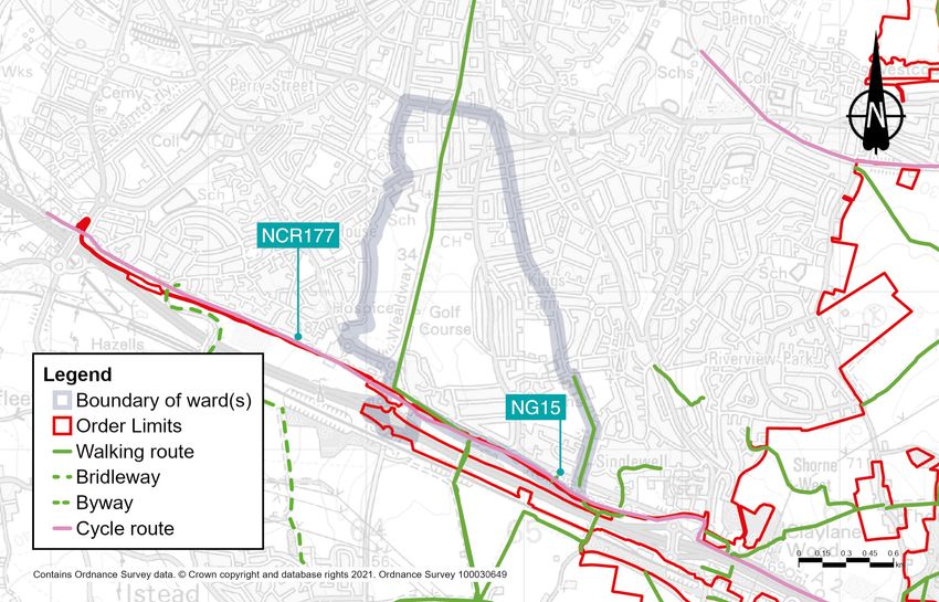
9.1.2 Summary of impacts
Table 9.1: Summary of impacts during the project’s construction and operation

 Topic              Construction                             Operations

 Traffic            Impacts                                  Impacts
                    There may be some additional local       There would be very little change in
                    vehicles on the A227 Wrotham Road        traffic in the Woodlands ward as a
                    if traffic is deterred from using the    result of the new road opening, except
                    Gravesend East junction. This may        along Wrotham Road. Further details
                    lead to some delays at junctions along   of the predicted changes in traffic flow
                    the Wrotham Road within the ward.        can be found in the Traffic section of
                                                             this chapter.
                    Mitigation
                    We have reduced HGV journeys. We         Mitigation
                    propose haul roads off the public        Once the project is operational, traffic
                    highway for construction vehicles,       impacts on the affected road network
                    which would reduce their use of local    would be monitored, including local
                    roads. We would reduce A2 closures       roads.
                    and limit them to nights and weekends
                    as much as possible.

440                                          Lower Thames Crossing Ward impact summaries 2021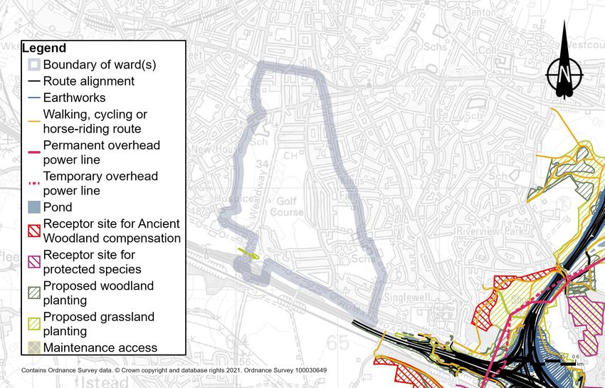
Topic                Construction                                 Operations

 Public transport     Buses                                        Buses
                      There may be some increases to               There are no discernible changes
                      journey times on coach services on           to bus journeys predicted once the
                      the A2 due to activities in adjacent         project is operational.
                      wards.
                                                                   Rail
                      Rail                                         There would be no discernible
                      During construction, there would be          changes to rail services from or access
                      no noticeable changes in local journey       times to Gravesend station once the
                      times to Gravesend station and no            project is operational.
                      changes to rail services at that station.

 Footpaths,           Impacts                                      Impacts
 bridleways and       One bridleway and one cycle route            The section of a cycle route that
 cycle routes         would be impacted during the                 runs through these wards would be
                      construction period to allow for utilities   unaffected by the road when it opens,
                      diversions works.                            but would be affected in other sections
                                                                   of the route in neighbouring wards to
                      Mitigation                                   the west.
                      Closures of these two routes would
                      be reduced as much as possible to            Mitigation
                      lessen the impact on the local public        No mitigation required.
                      rights of way network.

Lower Thames Crossing Ward impact summaries 2021                                                           441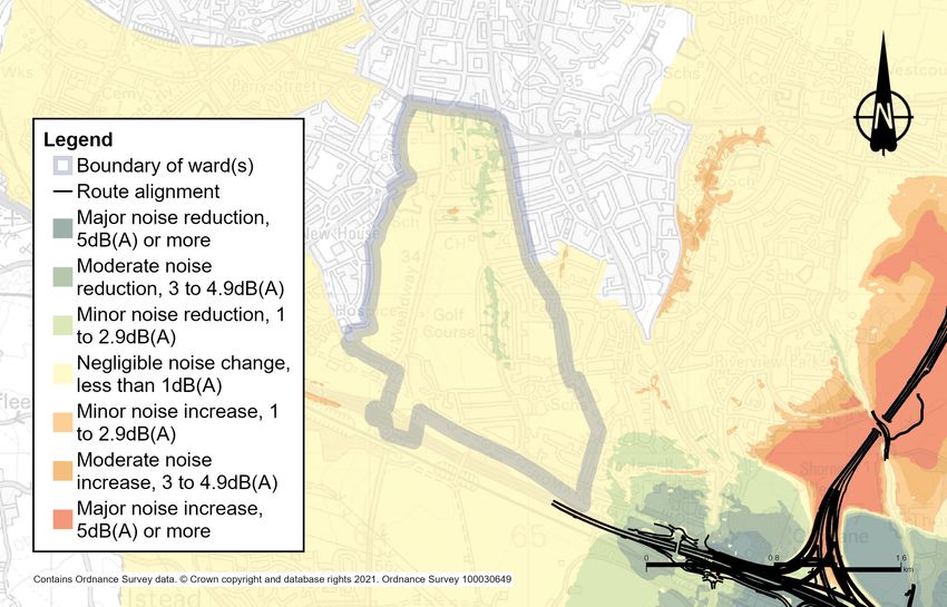
Topic                 Construction                              Operations

 Visual                Impacts                                   Impacts
                       Views towards construction activities     None identified.
                       would be limited. A small number of
                       homes along Epsom Close would             Mitigation
                       be able to see the adjacent utility       None required.
                       works along the Roman Road. Some
                       taller elements, such as new tunnel
                       entrance gantries may be visible.

                       Mitigation
                       None required.

 Noise and vibration   Impacts                                   Impacts
                       The construction activity associated      Once the new road is built, it is
                       with widening the A2 is expected to       predicted there would be between a
                       create noise in this ward. There would    minor increase and decrease in noise
                       be 24-hour, seven-day working in          in different areas of this ward. This is
                       some locations.                           due to changes in traffic flow and the
                                                                 speed on the existing road network.
                       There would be no percussive or
                       vibratory works within this ward. There   Mitigation
                       would be negligible changes in road       Low-noise road surfaces would be
                       traffic noise apart from Ridgeway         installed on new and resurfaced roads.
                       Avenue, which is predicted to have a
                       minor increase in noise and Harman
                       Avenue, which is predicted to have a
                       moderate increase in noise during year
                       1 of construction.

                       Mitigation
                       Construction noise levels would be
                       controlled by mitigation measures
                       set out in the REAC. There are also
                       measures presented in the CoCP.

442                                            Lower Thames Crossing Ward impact summaries 2021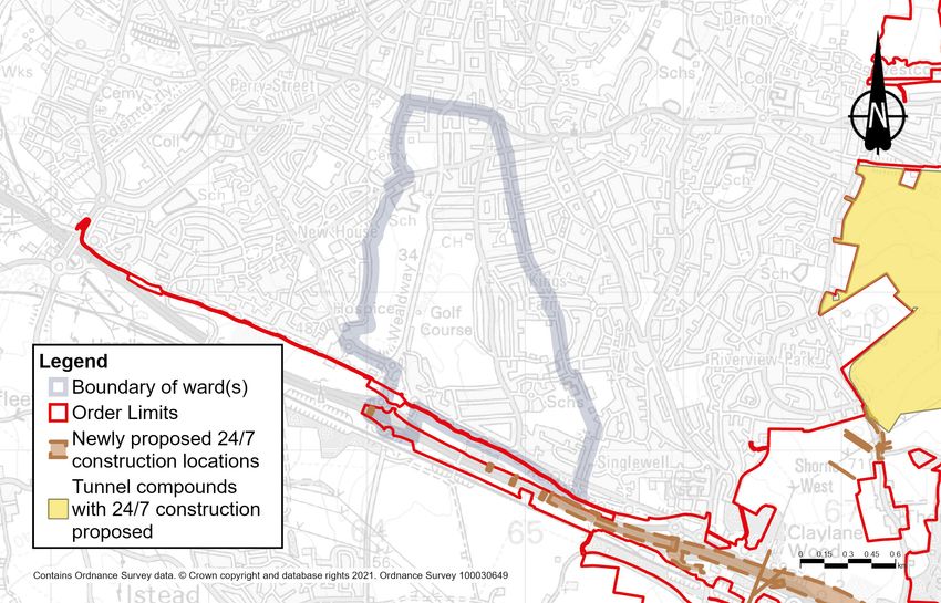
Topic                Construction                                Operations

 Air quality          Impacts                                     Impacts
                      A few properties located along the          There are no predicted exceedances
                      A2 corridor may experience dust             of NO2 or PM10.
                      and emissions from construction
                      equipment and traffic during the            Mitigation
                      construction phase.                         No essential mitigation is required.

                      Analysis of the construction phase
                      traffic flows associated with the project
                      indicate there would be a minor
                      worsening in air quality in the area
                      along Singlewell Road during 2024.

                      Mitigation
                      The contractor would follow good
                      practice construction measures (which
                      are presented in the CoCP and REAC)
                      to minimise the dust. Construction
                      vehicles would need to comply with
                      emission standards. An Air Quality
                      Management Plan would be designed
                      in consultation with the relevant local
                      authorities. The plan would include
                      details of monitoring, which would
                      ensure measures are effectively
                      controlling dust and exhaust emissions.

Lower Thames Crossing Ward impact summaries 2021                                                         443
Topic    Construction                             Operations

 Health   Impacts                                  Impacts
          The construction phase of the project    Once the project is built, there would
          would present opportunities to access    be a 10% increase in accessibility to
          work and training.                       open space for local people.

          There are limited impacts predicted      Mitigation
          on this ward although there is the       No essential mitigation is required
          potential for changes in the area that   for health other than those
          may result in negative impacts on        measures described in the
          health, for example, mental health and   noise mitigation section.
          wellbeing. These include increased
          traffic noise, dust and emissions from
          construction equipment and traffic,
          and changes in access to open space
          such as the temporary closures of
          footpaths.

          Mitigation
          The negative impacts would be
          mitigated through the good practice
          construction measures presented in
          the CoCP and REAC relating to
          noise, working hours and
          community engagement.

444                              Lower Thames Crossing Ward impact summaries 2021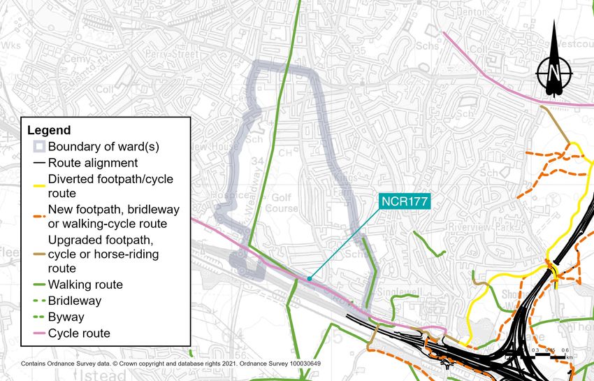
Topic                Construction                                Operations

 Biodiversity         Impacts                                     Impacts
                      The construction of the project would       None identified.
                      involve the removal of areas of habitat,
                      both temporarily and permanently,           Mitigation
                      and disturbance to retained habitat for     None required.
                      the new road. These habitats support
                      a number of protected and notable
                      species which would be impacted
                      including reptiles.

                      Mitigation
                      Vegetation clearance would take place
                      in winter to avoid impacting breeding
                      birds. Protected species would be
                      relocated, carried out under a Natural
                      England licence. Impacts would be
                      controlled through the range of good
                      practice measures set out in the CoCP
                      and REAC.

 Built heritage       Impacts                                     Impacts
                      There is likely to be an indirect effect    None identified.
                      (additional noise, lighting and visible
                      construction activity) on some built        Mitigation
                      heritage assets due to construction         None required.
                      work on the A2 Watling Street. Grade
                      II listed Orchard House and Corner
                      Cottage would experience temporary
                      minor change to their setting as they are
                      located just north of the A2.

                      Mitigation
                      Mitigation measures are presented
                      in the REAC, the CoCP and the Design
                      principles.

 Contamination        Impacts                                     Impacts
                      None identified.                            None identified.

                      Mitigation                                  Mitigation
                      None required.                              None required.

Lower Thames Crossing Ward impact summaries 2021                                     445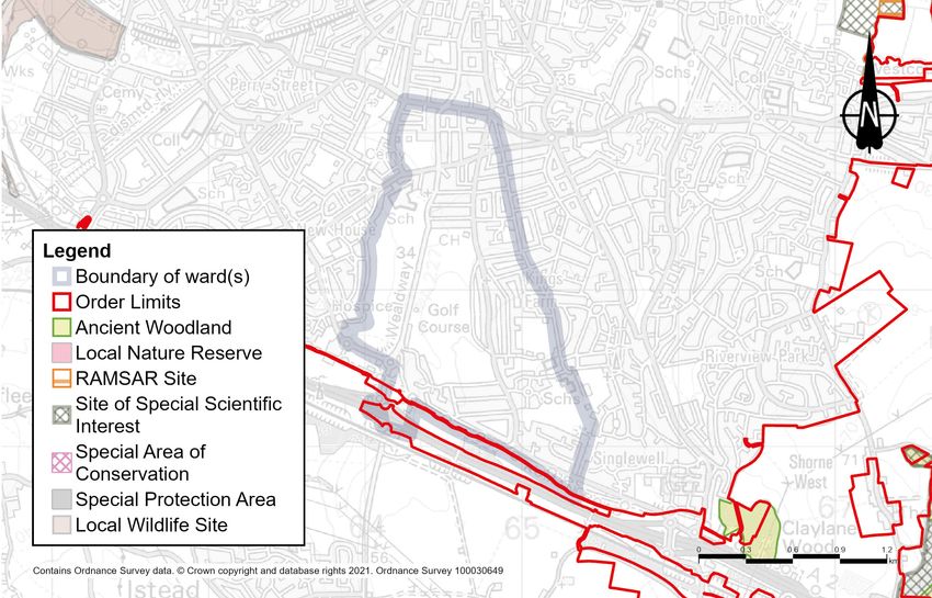
9.2 Project description
                             9.2.1 Construction
                             Construction activities
                             More information about how the area would look during
                             construction, including visualisations, can be found in the
                             Construction update.

                             Part of our proposed Order Limits (the area of land required
                             to construct and operate the project, formerly known as the
                             development boundary), extends from an existing compound
                             at Marling Cross in Shorne, Cobham and Luddesdown ward
                             to a National Grid site west of Hall Road. This is to support the
                             proposed installation of four underground power cables from
                             the National Grid site to the new primary substation at the A226.
                             The power cables and associated works would pass through
                             Woodlands ward.

  Figure 9.2: Main construction areas in Woodlands ward

446                                      Lower Thames Crossing Ward impact summaries 2021
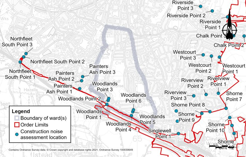
The power cables would be installed using trenchless methods
under Hall Road and Wrotham Road. The remainder, along the
Roman Road bridleway, would be mostly open cut and delivered
in sections, with barriers moving as work progressed. Chapter 2
of the Construction update provides an overview of how existing
utilities would be affected by our plans to build the new road,
with further detail including maps in chapter 3. Chapter 2 of the
Operations update also describes the project’s impacts on utilities,
including a map showing the utilities that would be repositioned to
accommodate the new road.

Construction compounds and Utility Logistics Hubs
Construction compounds are fenced-off areas, accessible to
construction traffic, which provide the facilities for our project to be
built efficiently. For example, compounds would provide parking,
storage for machinery and materials, offices, welfare facilities,
refuelling, and vehicle and wheel-washing facilities to make sure
vehicles leaving the compound do not dirty local roads.

No construction compounds or Utility Logistics Hubs are proposed
in Woodlands ward.

Construction routes on public roads
The A2 would be used as a construction route.

Construction schedule
Construction of the entire project is scheduled to last for six years
from 2024 to 2029. To complete our construction programme
efficiently, we would divide activities into packages of work, carried
out in a coordinated way. Maps and programmes for the work
packages in Kent can be found in chapter 3 of the Construction
update. The utility works in this ward are expected to take around 15
months, towards the beginning of the overall construction schedule.

Construction working hours
Most construction activities in this ward would take place during
core hours, from 7am to 7pm on weekdays and 7am to 4pm on
Saturdays. However, there would be circumstances when our
working hours would need to be extended. For example, connecting
new roads to existing ones would be carried out when there is less
traffic, so it is safer for both construction workers and road users.
Working outside the core hours can also benefit road users by
reducing the need for traffic management measures during peak
times. More information about working hours is set out in the Noise
and vibration section below and in the CoCP.

Lower Thames Crossing Ward impact summaries 2021                           447
Traffic management
      There are no construction traffic management measures planned
      in the Woodlands ward.

      Measures required across the project would include narrow lanes,
      reduced speed limits, lane closures and temporary traffic lights.
      We have tried to minimise traffic management measures wherever
      practical. However, they would be necessary in some places to
      allow construction traffic and local communities to travel safely,
      while providing construction workers with sufficient space to
      operate. An overview of the traffic management required across
      the project can be found in the Outline Traffic Management Plan
      for Construction. All traffic management measures are based on
      an indicative construction programme, which would be finalised by
      the appointed contractor. The contractor’s final traffic management
      plans would be subject to approval by the Secretary of State for
      Transport, following consultation with the local highways authority.

      9.2.2 Operations
      The completed project
      For more information about the completed project, see the
      Operations update, as well as the large-scale figures in Map Book
      1: General Arrangements.

      Changes to the project since our design
      refinement consultation
      There have been changes to the Order Limits in Woodlands ward
      since our design refinement consultation in July 2020. These are
      in the area where the works on the underground power cables
      are proposed. Our ongoing discussions with the local authority
      and utility company have allowed us to realign the proposed utility
      works and we have reduced the Order Limits accordingly.

448               Lower Thames Crossing Ward impact summaries 2021
Impacts on open space and common land In Woodland ward, we propose permanently acquiring rights within the Cyclopark for the purposes of maintaining the newly installed underground power cable along or adjacent to the existing bridleway on Roman Road. The open space affected by these utility works would be reinstated and access to the land would be unaffected once construction is complete. The amount of land required within the Cyclopark has been reduced since the design refinement consultation, therefore reducing the temporary impact on the open space site. More information about our proposals for compensating for impacts on open space land (which includes special category and recreational land), including proposals we have consulted on previously, can be found in chapter 3 of our Operations update. Figure 9.3: Main features of the completed project Lower Thames Crossing Ward impact summaries 2021 449
9.3 Traffic
      We carried out traffic assessments to understand how roads near
      the project would be affected during the project’s construction
      and once it is operational, compared with the situation if the
      project was not built. Information about how we carried out these
      assessments can be found in chapter 4 of the Operations update.

      9.3.1 Construction
      Construction impacts
      Information about construction activities in this ward, including
      construction routes on public roads, can be found in the Project
      description section above.

      There may be some additional local vehicles on the A227 Wrotham
      Road if traffic is deterred from using the Gravesend East junction.
      This may lead to some delays at the junctions along the Wrotham
      Road within the ward.

      Measures to reduce construction traffic impacts
      Our approach to construction has been refined after further
      investigations and feedback received from the public and
      stakeholders. A summary of the proposed measures to reduce the
      volume of construction materials transported in and out by road
      can be found in chapter 2 of the Construction update. In addition
      to reducing the volume of HGV journeys needed for the project’s
      construction, we would avoid the long-term closure of the A2/
      M2 during the construction period to reduce the impacts on local
      communities and the wider road network. Instead, to carry out
      the required works on the A2/M2, we would only close the road
      overnight or at weekends when it is less busy.

450 Lower Thames Crossing Ward impact summaries 2021 We would implement the Gravesend East junction northern roundabout works as early as possible during construction, so local traffic could benefit from the changes as soon as possible. We would minimise the use of the local road network as far as practical by building temporary offline haul routes that link the strategic road network directly to the construction areas, including directly from the A2 eastbound. 9.3.2 Operations Operational impacts Traffic modelling has been carried out to predict the change in traffic flows on roads in the area, including those within or on the boundary with this ward for the first year of operation, 2029. Figures 9.4, 9.6 and 9.8 below show the predicted changes in traffic in the morning peak (7am to 8am), interpeak (an average hour between 9am and 3pm) and evening peak (5pm to 6pm) measured in Passenger Car Units (PCUs per hour), where 1 PCU is equivalent to a car, and 2.5 PCUs is equivalent to an HGV. Figures 9.5, 9.7 and 9.9 show the predicted percentage changes in traffic flow during the morning, interpeak and evening peak. For information about how we assessed operational traffic impacts, see chapter 1. For more information about how we carried out our traffic modelling, see chapter 4 of the Operations update. There would be very little change in traffic in the Woodlands ward as a result of the new road opening, except along Wrotham Road and Coldharbour Road. Coldharbour Road would generally not experience any change in traffic greater than 50 PCUs an hour; the exception is eastbound in the morning peak hour where the increase is between 50 and 250 PCUs an hour. Along the Wrotham Road outside the St George’s Church of England Academy, the traffic increases by between 50 and 250 PCUs northbound in the morning peak hour. This is an increase of between 10% and 20%. In all other time periods, the change in traffic flows would be less than 50 PCUs. Southbound, the change in traffic flows is less than 50 PCUs in all modelled time periods. Lower Thames Crossing Ward impact summaries 2021 451
Coldharbour Road would generally not experience any change in
      traffic greater than 50 PCUs an hour; the exception is eastbound in
      the morning peak hour where the increase is between 50 and 250
      PCUs an hour.

      On the Wrotham Road, between the A2 and the junction with
      Coldharbour Road, northbound the traffic flows increase in the
      morning peak period by between 50 and 250 PCUs, an increase
      of less than 10%. Southbound traffic flows would increase by
      between 50 and 250 PCUs, an increase of less than 10% in the
      morning peak hour and an average interpeak period. Where the
      A227 Wrotham Road crosses over the A2, the traffic flows would
      increase northbound by between 50 and 250 PCUs in all modelled
      time periods. This is an increase of between 20% and 40% in the
      morning peak hour and less than 10% in the other time periods.
      Southbound, the increase in traffic flows would be between 50
      and 250 PCUS in the evening peak hour, an increase of between
      10% and 20%.

      On the offslip westbound from the A2 onto the Wrotham Road
      junction, the increase in traffic flows would be between 50 and 250
      PCUs in each modelled time period. This is an increase of over
      40% in the morning peak hour and between 10% and 20% in the
      interpeak period and the evening peak hour. The eastbound onslip
      from the Wrotham Road onto the A2 would experience an increase
      in traffic flows of between 50 and 250 PCUs in the morning peak
      hour and an average hour in the interpeak period. This is an
      increase of between 10% and 20%.

452               Lower Thames Crossing Ward impact summaries 2021
Figure 9.4: Predicted change in traffic flows (PCUs) with the project during the
morning peak in 2029
Legend
Boundary of
Ward(s)
Below -1000
-999 to -500
-499 to -250
-249 to -50
-49 to +50
+51 to +250
+251 to +500
+501 to +1000
Over +1001
The Project
0 0.15 0.3 0.45 0.6
km
Contains Ordnance Survey data. © Crown copyright and database rights 2021. Ordnance Survey 100030649
Figure 9.5: Predicted percentage change in traffic flows with the project during the
morning peak in 2029
Legend
Boundary of
Ward(s)
Below -40%
-40% to -20%
-20% to -10%
-10% to +10%
(or change less
than 50 PCUs)
+10% to +20%
+20% to +40%
Over +40%
The Project
0 0.15 0.3 0.45 0.6
km
Contains Ordnance Survey data. © Crown copyright and database rights 2021. Ordnance Survey 100030649
Lower Thames Crossing Ward impact summaries 2021 453Figure 9.6: Predicted change in traffic flows (PCUs) with the project during the
interpeak period in 2029
Legend
Boundary of
Ward(s)
Below -1000
-999 to -500
-499 to -250
-249 to -50
-49 to +50
+51 to +250
+251 to +500
+501 to +1000
Over +1001
The Project
0 0.15 0.3 0.45 0.6
km
Contains Ordnance Survey data. © Crown copyright and database rights 2021. Ordnance Survey 100030649
Figure 9.7: Predicted percentage change in traffic flows with the project during the
interpeak period in 2029
Legend
Boundary of
Ward(s)
Below -40%
-40% to -20%
-20% to -10%
-10% to +10%
(or change less
than 50 PCUs)
+10% to +20%
+20% to +40%
Over +40%
The Project
0 0.15 0.3 0.45 0.6
km
Contains Ordnance Survey data. © Crown copyright and database rights 2021. Ordnance Survey 100030649
454 Lower Thames Crossing Ward impact summaries 2021Figure 9.8: Predicted change in traffic flows (PCUs) with the project during the
evening peak in 2029
Legend
Boundary of
Ward(s)
Below -1000
-999 to -500
-499 to -250
-249 to -50
-49 to +50
+51 to +250
+251 to +500
+501 to +1000
Over +1001
The Project
0 0.15 0.3 0.45 0.6
km
Contains Ordnance Survey data. © Crown copyright and database rights 2021. Ordnance Survey 100030649
Figure 9.9: Predicted percentage change in traffic flows with the project during the
evening peak in 2029
Legend
Boundary of
Ward(s)
Below -40%
-40% to -20%
-20% to -10%
-10% to +10%
(or change less
than 50 PCUs)
+10% to +20%
+20% to +40%
Over +40%
The Project
0 0.15 0.3 0.45 0.6
km
Contains Ordnance Survey data. © Crown copyright and database rights 2021. Ordnance Survey 100030649
Lower Thames Crossing Ward impact summaries 2021 455Changes to journey times
Figure 9.10 shows the change in the area that could be reached
within a 30-minute drive from the centre of the ward with and
without the project. Figure 9.11 shows the change in area that
can be reached within a 60-minute drive. The areas have been
calculated for the morning peak hour (7am to 8am). The number
of jobs within a 30-minute catchment area would increase by 50%
with the project, an increase of 187,700 jobs. The number within
a 60-minute drive increases by 22%, and would provide access
to an additional 555,000 jobs. Despite the project providing a
substantial net gain in access for motorists within Woodlands ward,
there are areas (shown in orange on the maps below) that would
no longer be accessible by car within 30 or 60 minutes because
of changes to traffic flows on the wider road network. The area of
white space north of the River Thames within the 30-minute map
reflects the predicted journey times in that area.
Figure 9.10: Change in the area that motorists could drive to within 30 minutes from
Woodlands ward
Legend
Boundary of Ward(s)
Less than 30 mins with and
without project
Less than 30 mins with
project and more than 30
mins without
Less than 30 mins without
project and more than 30
mins with
0 1.5 3 4.5 6
km
Contains Ordnance Survey data. © Crown copyright and database rights 2021. Ordnance Survey 100030649
456 Lower Thames Crossing Ward impact summaries 2021Figure 9.11: Change in the area that motorists could drive to within 60 minutes from
Woodlands ward
Legend
Boundary of Ward(s)
Less than 60 mins with
and without project
Less than 60 mins with
project and more than 60
mins without
Less than 60 mins without
project and more than 60
mins with
0 4.5 9 13.5 18
km
Contains Ordnance Survey data. © Crown copyright and database rights 2021. Ordnance Survey 100030649
Operational traffic flows
Once the road is open, traffic impacts on the affected road
network would be monitored, including local roads. Where
appropriate, we would work with the relevant highway authority
to seek funding from the Department for Transport for further
interventions.
Lower Thames Crossing Ward impact summaries 2021 4579.4 Public transport
Current situation
There are no railway stations within the ward but Gravesend station
is used by Southeastern and Thameslink services to run journeys
from Kent through to London Charing Cross north of the ward.
Woodlands ward is served by several bus routes including the 3,
223, 305, 306, 308, 416, 455, 717, 719, 720, 722, 750, 751, 765,
774, the school buses Meopham1, VIGO1, NAG2, and regional
coach services using the A2.
9.4.1 Construction
Buses
There would be no changes to bus journey times during
construction as a result of activities within Woodlands ward. There
may be some increases to journey times for buses and coaches
using the A2 due to activities in adjacent wards.
Rail
There would be no noticeable change in local journey times to
Gravesend station and no change to rail services at that station.
9.4.2 Operational
Buses
Once the new road opens, there would be no changes to bus
routes through the ward and no noticeable change to bus
journey times.
Rail
There would be no noticeable change in local journey times to
Gravesend station and no change to rail services at that station.
458 Lower Thames Crossing Ward impact summaries 20219.5 Footpaths, bridleways and cycle routes Existing situation Woodlands is a largely suburban ward, split by the Singlewell Road and the Mid Kent Golf Club. The ward has a small network of local footpaths. For other potential impacts, see the other section areas in this chapter, such as Visual, and Noise and vibration. Figure 9.12: Footpaths, bridleways and cycle routes in the vicinity of the project in Woodlands ward Lower Thames Crossing Ward impact summaries 2021 459
9.5.1 Construction
Construction impacts
Due to the construction activities around the A2 in this ward, there
would be minor disruptions during the construction period.
Footpath NG15 would need to be closed for six months to
allow utility works where it crosses the Order Limits.
Cycle route NCR177 within Woodlands ward would remain
open during the construction period.
9.5.2 Operations
Operational impacts
Overall, the proposals for walking, cycling, and horse riding
include more than 46km of new, diverted, extended or upgraded
footpaths, bridleways and cycleways. These would provide
greatly improved connections across the project. We developed
our proposals after consultation and engagement with local
communities and stakeholders. For an overview of the proposed
improvements to footpaths and bridleways across the Lower
Thames Crossing, see chapter 2 of the Operations update.
The section of NCR177 within Woodlands ward would not
be affected by any permanent changes. However, a section
of the route east of Gravesend East junction would close
permanently, with two new routes being implemented south of
the A2, one more direct route along the new connector road
south of the A2 and a more scenic route through Jeskyns
Woods. For more information, see the Footpaths, bridleways
and cycle routes section in chapter 3.
460 Lower Thames Crossing Ward impact summaries 2021Figure 9.13: Proposed footpaths, bridleways and cycle routes Lower Thames Crossing Ward impact summaries 2021 461
9.6 Visual
      Existing situation
      Of the main populated areas, only those homes on the southern
      edge of Gravesend have views towards the land on which the
      project would be built. East of the A227, there are views of the
      land on which the project would be built from a short section of
      the Wealdway long-distance footpath along Roman Road, until the
      route crosses the A2 on a footbridge. Views of the land on which
      the project would be built are also visible from cycle route NCR177
      along Roman Road.

      Current views towards the land on which the project would be
      built from homes along Old Watling Street/Watling Street and
      Hever Court Road are largely screened or densely filtered by a
      combination of roadside hedgerows and garden vegetation. From
      Epsom Close, views towards the project include glimpses of
      gantries along the A2 corridor, partially screened by
      garden vegetation.

      The Wealdway long-distance footpath along Roman Road lies
      within the land on which the project would be built. Current views
      from both the Wealdway and NCR177 include the green corridor
      between the edge of Gravesend and linear planting parallel with
      the A2. Views towards the land on which the project would be
      built, taking in the A2 corridor, are restricted by linear belts of trees
      and roadside vegetation.

      East of the Wealdway footbridge crossing the A2, there are slightly
      more open views from NCR177 toward the project, including
      the A2 corridor, of grassland, scrub and intermittent trees, with
      glimpses of gantries.

462                Lower Thames Crossing Ward impact summaries 2021
9.6.1 Construction Construction impacts For more information about how the area would look during construction, refer to the construction visualisations in the Construction update. The main construction activities likely to be seen from this ward are: utilities diversions widening of the A2 corridor and connection works Views of construction activities would be limited to a small number of homes along Epsom Close, where adjacent utilities works along Roman Road would be partially visible in filtered views and from NCR177. Beyond these works, construction activities along the A2 would be mostly screened by roadside vegetation, although taller elements such as new tunnel entrance gantries, may be visible. From a short stretch of the Wealdway long-distance path, which follows Roman Road, there would be views of utility works taking place in or next to Roman Road. Within this ward the route of NCR177 would remain unchanged, however to the east of this ward NCR177 would be permanently diverted as a result of the project. Measures to reduce visual impacts during construction Given the limited views of the project from this ward, no specific mitigation measures are proposed. 9.6.2 Operations Operational impacts By 2029, the year of opening, the widening works to the A2 would be complete and the land affected by utilities works along Roman Road would have been restored. More information about the completed project can be found in the Project description section above. There would be no long-lasting visual impacts from the project on Woodlands ward. Measures to reduce visual impacts during operation Screen planting would form the primary mitigation in this ward. Lower Thames Crossing Ward impact summaries 2021 463
9.7 Noise and vibration
      We have carried out noise and vibration assessments for both the
      construction and operational phases of the project. As explained
      in chapter 1, some of the assessments set out below are based
      on earlier versions of the project. The information provided still
      presents a reasonable representation of the likely effects from the
      proposals put forward during this consultation.

      Existing situation
      The existing noise environment in Woodlands ward is mainly
      characterised by traffic noise, with a contribution from the railway,
      agriculture and human activity. The main sources of road traffic
      noise in this ward are from the A2 and B261.

      As part of our environmental assessment process, we carried out
      surveys of existing background noise at one location in the ward,
      which was agreed with the local authority. The levels monitored at
      this location recorded an existing noise level of 61dB(A)2 during
      the day.

      To understand how noise levels would vary with and without the
      project, we used modelling to predict what noise levels would be
      like in the project’s proposed opening year if the project was not
      built. We modelled this because we cannot assume that noise
      levels when the project opens would be the same as they are now.
      For example, our assessment of the opening year noise levels
      takes into account predicted changes in traffic levels. We also
      modelled the predicted noise levels for the opening year with the
      project in place. This provides a useful comparison as to how the
      project would change the noise levels in the project’s opening year
      if the road was built.

      In the opening year, noise levels without the project are predicted
      to range, on average, from 40 to 81dB(A) during the day and from
      29 to 66dB(A) during the night at the identified location in the ward.
      As such, our noise assessments predict that by opening year noise
      levels would increase compared to the existing situation even if the
      road is not built. Information about noise levels with the project,
      during its construction and operation, are presented below.

      2	Decibel (dB) is the unit used to measure noise levels, with dB(A) being a
         standardised way of averaging noise levels that account for how humans
         hear sounds. The typical level of sounds in the environment ranges from
         30 dB(A), which is a quiet night-time level in a bedroom, to 90 dB(A), which
         is how it would sound by a busy road. See chapter 1 for more information
         about what decibel levels mean.

464                 Lower Thames Crossing Ward impact summaries 2021
9.7.1 Construction Daytime construction impacts The main construction activities that are expected to give rise to noise and vibration in this ward are those associated with widening the A2. There are no main works compounds or Utility Logistics Hubs currently proposed to be located within the Woodlands ward, nor are there any haul roads proposed within this ward. There are no percussive or vibratory works proposed in Woodlands. Construction noise levels have been predicted at six locations across this ward, chosen to provide a representative level of noise communities are expected to experience during construction. For more information about how we carried out these assessments, see chapter 1. Noise levels are shown using the standard units for major projects, dB LAeq (12-hour), which represent the average noise level for the assessed 12-hour daytime period. While there might be short- term noises that are louder than the noise level shown during the assessed period, the averaged figure provides a fair representation of what the overall noise impacts would be. Figure 9.14: Construction noise assessment locations in Woodlands ward Lower Thames Crossing Ward impact summaries 2021 465
Figure 9.14 shows the locations at which we have
predicted the daytime construction noise during the project’s
construction phase.
Each vertical bar in figure 9.15 and 9.16 shows the predicted
noise levels for that month of the construction period (months
1 to 72). The horizontal green line in each chart represents the
existing background noise level at each assessment point without
the project. The horizontal red line shows the level at which
construction noise would exceed acceptable thresholds (see
chapter 1 for more information about these thresholds). If noise
is predicted to exceed acceptable levels, then specific measures
would be implemented to reduce the noise.
The predicted construction noise levels show that higher levels and
disturbance would be experienced closer to construction activity.
Levels gradually diminish as a result of increased distance with
additional buildings and other features screening the noise from
more distant residential areas.
With reference to figure 9.15 the following summarises the noise
level changes over the construction period for points 1 to 3:
At point 1, construction noise levels are predicted to range from
32 to 65dB LAeq (12-hour). Construction noise is not expected
to exceed the existing background noise levels.
At point 2, construction noise levels are predicted to range from
21 to 53dB LAeq (12-hour). Construction noise is not expected
to exceed the existing background noise levels.
At point 3, construction noise levels are predicted to range
from 16 to 44dB LAeq (12-hour). Construction noise is not
expected to exceed the existing background noise levels.
466 Lower Thames Crossing Ward impact summaries 2021Figure 9.15: Construction noise by month for points 1, 2 and 3 in Woodlands ward
100
90 Woodlands Point 1
Construction Noise Level dB LAeq(T)
80
70
60
50
40
30
20
10
0
1 6 12 18 24 30 36 42 48 54 60 66 72
100
90 Woodlands Point 2
Construction Noise Level dB LAeq(T)
80
70
60
50
40
30
20
10
0
1 6 12 18 24 30 36 42 48 54 60 66 72
100
Woodlands Point 3
90
Construction Noise Level dB LAeq(T)
80
70
60
50
40
30
20
10
0
1 6 12 18 24 30 36 42 48 54 60 66 72
Construction Month
Construction Noise Level Existing Noise Level dB(A) BS5228 Limit
Lower Thames Crossing Ward impact summaries 2021 467With reference to figure 9.16 the following summarises the noise
level changes over the construction period for points 4 to 6:
At point 4, construction noise levels are predicted to range
from 15 to 58dB LAeq (12-hour). Construction noise is not
expected to exceed the existing background noise levels.
At point 5, construction noise levels are predicted to range
from 23 to 41dB LAeq (12-hour). Construction noise is not
expected to exceed the existing background noise levels.
At point 6, construction noise levels are predicted to range
from 18 to 39dB LAeq (12-hour). Construction noise is not
expected to exceed the existing background noise levels.
468 Lower Thames Crossing Ward impact summaries 2021Figure 9.16: Construction noise by month for points 4, 5 and 6 in Woodlands ward
100
90 Woodlands Point 4
Construction Noise Level dB LAeq(T)
80
70
60
50
40
30
20
10
0
1 6 12 18 24 30 36 42 48 54 60 66 72
100
90 Woodlands Point 5
Construction Noise Level dB LAeq(T)
80
70
60
50
40
30
20
10
0
1 6 12 18 24 30 36 42 48 54 60 66 72
100
Woodlands Point 6
90
Construction Noise Level dB LAeq(T)
80
70
60
50
40
30
20
10
0
1 6 12 18 24 30 36 42 48 54 60 66 72
Construction Month
Construction Noise Level Existing Noise Level dB(A) BS5228 Limit
Lower Thames Crossing Ward impact summaries 2021 469Figure 9.17: Newly proposed and tunnel 24/7 working locations in Woodlands ward
24/7 construction working
In addition to the changes to the daytime noise impacts presented
in the section above, 24-hour, seven-day construction working is
proposed at the locations shown in figure 9.17 above.
These locations are where works may need to be carried out at
night to maintain safety and reduce disruption to road and utility
networks. The works in this area are expected to be night-time or
weekend highways works. These works could have an impact on
local communities, and we would work with the local authority to
manage them.
470 Lower Thames Crossing Ward impact summaries 2021Construction traffic noise impacts Maps showing the predicted change in road traffic noise on roads within Woodlands ward during each year of the construction can be found in chapter 7 of the Construction update. Based on the currently available traffic data (which offers a representative picture of what receptors within the ward are likely to experience), during the construction period there would be negligible changes in road traffic noise (less than 1dB change in noise levels) during all construction years, except along the following roads where increases in noise levels been predicted. For more information about how we define noise impacts (negligible, minor, moderate and major), see chapter 1. Table 9.2: Construction traffic noise in Woodlands ward Affected road(s) Predicted noise impact Construction year(s) Ridgeway Avenue Minor increase in noise levels 1 Harman Avenue Moderate increase in noise levels 1 Measures to reduce construction noise levels Construction noise levels would be controlled by using Best Available Techniques (BAT), with specific measures used at certain locations such as: installing and maintaining hoarding around the construction compounds installing temporary acoustic screening around the construction areas likely to generate noise keeping site access routes in good condition with onsite assessments to inspect for defects such as potholes turning off plant and machinery when not in use maintaining all vehicles and mobile plant so loose body fittings or exhausts do not rattle or vibrate using silenced equipment where available, in particular generators and pumps no music or radios would be played outdoors onsite for entertainment purposes Lower Thames Crossing Ward impact summaries 2021 471
site layout would be planned to ensure that reversing is kept to
a practicable minimum. Required reversing manoeuvres would
be managed by a trained banksman/vehicle marshal to ensure
they are conducted safely and concluded quickly to reduce the
noise from vehicle reversing warnings
non-percussive demolition techniques would be used where
reasonably practical to reduce noise and vibration impact
careful consideration of the location and layout of compounds
to separate noise-generating equipment from sensitive
receptors, and the use of mains electricity rather than
generators, where possible
minimisation of construction vehicle traffic by selecting local
suppliers along the project route, where possible, using local
workforces, and by reducing the transport of material for
earthworks construction
All control measures, including those above, fall under the
principles of BAT and are outlined in the REAC. For more
information, see the sections NV001 to NV010, which set out
how we would work under the supervision of the relevant
local authorities to implement noise-reduction measures
where necessary.
The CoCP sets out additional measures that would be
implemented to reduce noise and vibration during the
construction period
9.7.2 Operations
Operational noise impacts
Woodlands ward is located approximately 1.4km to the west of the
main project route and, as such, there would be no direct noise
impacts from the project in the ward. Noise impacts within this
ward would be as a result of changes in traffic flow, the number of
HGVs, and traffic speeds on the existing road network within the
ward, and changes to the A2 in the south of the ward.
472 Lower Thames Crossing Ward impact summaries 2021Figure 9.18 Noise impacts during operation in Woodlands ward Figure 9.18 above shows the predicted changes in traffic noise in the opening year of the project. Within the ward, changes in road traffic noise at identified noise sensitive locations (such as nearby properties) are predicted to range from a minor decrease in noise levels of between 1.0 and 2.9dB, to a minor increase in noise levels of between 1.0 and 2.9dB. For more information about how we define noise impacts (negligible, minor, moderate and major), see chapter 1. Measures to reduce traffic noise and vibration during operation The main methods of controlling noise across the project would be, where practicable, to design the road within landscaped features such as cuttings and bunds (walls of earth). The use of low-noise surfacing would also reduce the traffic noise once the road is in use. No essential mitigation is required in this ward. For more information about the proposed measures to reduce operational noise, see the REAC (including references NV011 and NV013). Lower Thames Crossing Ward impact summaries 2021 473
9.8 Air quality
      We have carried out air quality assessments for both the
      construction and operational phases of the project. As explained
      in chapter 1, some of the assessments set out here are based on
      earlier versions of the project. The information provided here still
      presents a reasonable representation of the likely effects from the
      proposals presented during this consultation.

      Existing situation
      Within Woodlands ward, either side of the A2 and M2 have been
      declared an Air Quality Management Area (AQMA) due to yearly
      levels of airborne pollution being above accepted standards.
      AQMAs are areas that have been identified by local authorities
      as areas of poor air quality that require additional monitoring
      and controls. No other areas within the ward have been identified
      as AQMA.

      9.8.1 Construction
      Construction impacts
      Construction activities have the potential to affect nearby air quality
      through the release of dust and emissions from construction
      equipment and traffic. The areas most likely to be affected are
      those close to haul roads, compounds and soil storage areas.
      Properties more than 200 metres from the worksite, which is the
      majority of properties within this ward, are outside the area likely to
      be affected by construction dust or emissions from the worksite.
      In this ward, there are only a few properties within 200 metres of
      the worksite, including along the A2 corridor. Air quality impacts
      on these properties during construction would be temporary and
      we would put in place measures to minimise the dust impacts (see
      below).

      The proposed measures to reduce dust and emissions are ones
      that have been effective when used on similar construction
      projects in the past. The change in air quality during the
      construction phase would be negligible, and there would be no
      discernible effect on health. Our analysis of construction traffic
      predicts that the impact on most roads in this ward would be
      negligible from 2024 to 2029, although there would be a minor
      worsening in air quality in the area along the Singlewell Road as
      a result of the traffic management in place during 2024. More
      information about construction traffic impacts on air quality can be
      found in chapter 7 of the Construction update.

474               Lower Thames Crossing Ward impact summaries 2021
Measures to reduce air quality impacts during construction The impact of construction machinery and traffic on air quality would be controlled through the range of good practice measures set out in the CoCP and the REAC. For example, there would be measures to suppress dust, such as damping down dry haul roads and spoil heaps, as well as the use of low-emission machinery and vehicles. We would put in place an AQMP to ensure the measures set out in the CoCP and the REAC would effectively monitor and control dust and exhaust emissions. The location and type of monitoring would be submitted in advance to Gravesham Borough Council for consultation (see REAC entry AQ006). Figure 9.19: Predicted changes in NO2 within Woodlands ward once the new road is open Lower Thames Crossing Ward impact summaries 2021 475
9.8.2 Operations
      Operational impacts
      We have carried out an assessment of the operational impacts
      of the new road on air quality. The assessment area includes a
      200-metre buffer around the affected road network, with this area
      being the most likely to experience changes to air quality as a
      result of the new road. More information about air quality
      impacts once the road is open can be found in chapter 5 of
      the Operations update.

      At all locations within the ward, there are no predicted
      exceedances of air quality thresholds. There are receptors
      (properties or habitats that are sensitive to changes in air quality)
      within the ward, close to the north of the A2 that are predicted to
      experience a negligible change in the air quality for nitrogen dioxide
      (NO2), the main traffic-related pollutant3. The highest modelled
      yearly average NO2 concentration within this ward is 25.2 µg/m³,
      which is well below the yearly average threshold of 40µg/m³.
      Our assessment is based on our opening year model, which
      represents a worst-case scenario, without accounting for the
      increase in less-polluting vehicles on our roads over time.

      Measures to reduce air quality impacts
      during operation
      The assessed air quality impacts in this area as a result of the
      project would be negligible therefore monitoring or other mitigation
      measures would not be necessary once the new road is open.

      3	NO2 levels are measured in ‘micrograms per cubic metre’, or µg/m³, where a
         microgram is one millionth of a gram.

476                Lower Thames Crossing Ward impact summaries 2021
9.9 Health Existing situation A range of personal, social, economic and environmental factors influence our health. Different groups within the population may be more sensitive to these factors than others – for example, children, older people or those with pre-existing health conditions. Woodlands has a similar proportion of people under the age of 16 and over 60+ as Gravesham as a whole, and a similar proportion of white and people from an Asian background. According to the English Index of Multiple Deprivation, Woodlands has very low rates of deprivation and economic activity is high compared with Gravesham as a whole. Home ownership levels are also high (76.0%), with the remainder mostly in private rented and social rented property, 12.5% and 10.3% respectively. Around 84% of residents report their health to be very good or good (slightly higher than Gravesham as a whole). A lower proportion report that their day-to-day activities are limited a lot or a little as a result of a long-term disability (14.9%). Life expectancy at birth for Woodlands residents is 82.7 for males and 82.6 for females. When compared with the UK average, life expectancy rates (2013–2017) are higher in Woodlands for males, but lower for females. For deaths from all causes (these are causes where all or most deaths could potentially be prevented by public health interventions in the broadest sense), respiratory diseases, coronary heart disease and cancer rates are lower in Woodlands than for Gravesham as a whole. 9.9.1 Construction Construction health impacts Construction activities in Kent include establishing and operating the Southern Tunnel Compound, as well as earthworks and landscaping to create Chalk Park. More information about the activities affecting Woodlands ward residents is provided in the Project description section above. Elements of each of these activities have the potential to impact human health (including mental health and wellbeing), whether this is through noise associated with construction activities or construction traffic, air quality (as a result of dust emissions), severance caused by construction traffic or road and footpath closures. Lower Thames Crossing Ward impact summaries 2021 477
Woodland ward residents may experience effects on health as
a result of:
The main construction activities that are expected to give rise
to noise and vibration in this ward are those associated with
widening the A2. There are no main works compounds or
Utility Logistics Hubs currently proposed to be located within
the Woodlands ward, nor are there any haul roads proposed
within this ward.
There are no percussive or vibratory works proposed in
Woodlands.
The predicted construction noise levels show that higher
noise levels and disturbance would be experienced closer to
construction activity. Levels gradually diminish as a result of
increased distance with additional buildings and other features
screening the noise from more distant residential areas.
24-hour, seven-day construction working is proposed along
Watling Street towards the east of the ward. These locations
are where works may need to be carried out at night to
maintain safety and reduce disruption to road and utility
networks. The works in this area are expected to be night-time
or weekend highways works and could have an impact on
local communities.
Based on the currently available traffic data (which offers a
representative picture of what receptors within the ward are
likely to experience), during the construction period there would
be negligible changes in road traffic noise (less than 1dB)
during all construction years, except along Ridgeway Avenue
and Harman Avenue.
Views of construction activities would be limited to a small
number of homes along Epsom Close, where adjacent
utilities works along the Roman Road would be partially
visible in filtered views. Beyond these works, construction
activities along the A2 would be mostly screened by roadside
vegetation, although taller elements such as new tunnel
entrance gantries, may be visible.
478 Lower Thames Crossing Ward impact summaries 2021 Properties more than 200 metres from the worksite, which is the majority of properties within this ward, are outside the area likely to be affected by construction dust or emissions from the worksite. In this ward, there are only a few properties within 200 metres of the worksite, including along the A2 corridor. Air quality impacts on these properties during construction would be temporary and we would put in place measures to minimise the dust impacts. There are both positive and negative potential impacts on people’s health and wellbeing as a result of the construction stage. Through good communications and engagement, providing people with information about when construction works would take place and its impacts, negative impacts on people’s mental health and well-being would be reduced. Equally, some residents would see health and wellbeing benefits from improved access to work and training opportunities presented by construction activities (see the Traffic impacts section). Evidence from The Health Foundation has demonstrated a link between unemployment and poor mental health. Measures to reduce construction health impacts Other than measures relating to noise and visual impacts described above, no specific measures relating to health have been identified in this ward. Lower Thames Crossing Ward impact summaries 2021 479
9.9.2 Operations
Operational health impacts
Both positive and negative health outcomes may be experienced
by residents in Woodlands:
There would be an increase in accessibility to open space for
local people.
By 2029, the opening year, the widening works to the A2 would
be complete and the land affected by utilities works along
Roman Road would have been restored. There would no
long-lasting visual impacts from the project on the ward.
The ward is located approximately 1.4km to the west of the
main project and, as such, there would be no direct noise from
the project in the ward. Noise impacts within this ward would
be as a result of changes in traffic flow, the number of HGVs
and traffic speeds on the existing road network within the
ward, and changes to the A2 in the south of the ward.
Within the ward, changes in road traffic noise at identified
noise sensitive locations (such as nearby properties) are
predicted to range from a minor decrease in noise levels of
between 1.0 and 2.9dB, to a minor increase in noise levels
of between 1.0 and 2.9dB.
Measures to reduce operational health impacts
Other than measures relating to noise and visual impacts
described above, no other specific measures relating to health
have been identified in this ward.
480 Lower Thames Crossing Ward impact summaries 20219.10 Biodiversity Existing situation Only a small part of Woodlands ward falls within the project Order Limits, forming an area around the A2/M2 and A226 junction and the cycle lane north of the A2/M2. This habitat is limited to some landscape planting and grassland. Woodlands ward contains no designated or non-designated sites. We carried out surveys across the project to set a baseline for assessment, which identified reptiles in the landscape planting and grassland along the cycle route. Figure 9.20: Designated and non-designated biodiversity sites in Woodlands ward Lower Thames Crossing Ward impact summaries 2021 481
9.10.1 Construction
      Construction impacts
      To build the Lower Thames Crossing, areas of habitat would need
      to be removed both temporarily and permanently. This landscape
      planting and grassland habitat supports a range of protected
      and notable species that would be impacted by construction
      through direct habitat loss (reptile habitat), and disturbance to
      retained habitat.

      Measures to reduce biodiversity impacts
      during construction
      Vegetation clearance would take place during the winter to
      avoid any impact on breeding birds. Where this is not practical,
      clearance would be supervised by an ecological clerk of works
      to ensure no nests are disturbed or destroyed. Where protected
      species are present, they would be moved away from the site
      before any construction activities take place, either through habitat
      manipulation (for example, strimming to reduce the height of
      vegetation and displace reptiles), or translocation. Any habitat
      lost for temporary construction works would be reinstated
      after construction.

      The impact of construction on biodiversity would be controlled
      through the range of good practice measures set out in the CoCP
      and REAC. See chapter 1 of the Construction update for more
      information about this and the project’s other control documents.

      9.10.2 Operations
      Operational impacts
      The project’s operation is unlikely to cause significant additional
      disturbance within the ward beyond the existing impacts from the
      operation of the A2/M2.

      Measures to reduce biodiversity impacts
      during operation
      Landscape planting has been designed to screen the new road
      from the surrounding habitats. Newly created habitats would be
      managed to ensure that they provide a high-quality environment
      to support a broad range of plant and animal species. The impact
      of operation on biodiversity would be controlled through good
      practice measures set out in the CoCP and REAC. See chapter 1
      of the Construction update for more information about this and
      the project’s other control documents.

482               Lower Thames Crossing Ward impact summaries 2021
You can also read