A TRAFFIC CONGESTION FRAMEWORK FOR SMART RIYADH CITY BASED ON IOT SERVICES
←
→
Page content transcription
If your browser does not render page correctly, please read the page content below
(IJACSA) International Journal of Advanced Computer Science and Applications,
                                                                                                            Vol. 9, No. 4, 2018

  A Traffic Congestion Framework for Smart Riyadh
             City based on IoT Services

         1
             Hailah Ghanem Al-Majhad, 2 Arif Bramantoro, 2,3 Irfan Syamsuddin, 2,4 Arda Yunianta, 2 Ahmad Hoirul Basori,
                                              2,5
                                                  Anton Satria Prabuwono, 2 Omar M. Barukab
                 1
                   College of Computer and Information Sciences, Al Imam Mohammad Ibn Saud Islamic University,
                                                            Riyadh, Saudi Arabia
                        2
                          Faculty of Computing and Information Technology Rabigh, King Abdulaziz University,
                                                        Rabigh 21911, Saudi Arabia
                       3
                         Department of Computer and Networking Engineering, School of Electrical Engineering,
                                          Politeknik Negeri Ujung Pandang, Makassar, Indonesia
                                       4
                                         Faculty of Computer Science and Information Technology,
                                                     Mulawarman University, Indonesia
                                     5
                                       Master in Computer Science Program, Budi Luhur University,
                                                          Jakarta 12260, Indonesia

    Abstract—Internet of Things has become one of the most             population of Riyadh is approximately 4.9 million that is
challenging issues in many researches to connect physical things       flooding the roads with about 985,000 cars daily and an
through the internet by creating a virtual identity for everything.    average of 1.6 cars per family which 90% of them are private
Traffic congestion in Riyadh city is chosen due to the proliferation   cars [1]. It leads to an increase in congestion of the roads which
in the number of vehicles on Riyadh roads that is resulting in         is rapidly becoming a phenomenon that is seen every day.
grumbling by residents. Currently, there are few reliable services
offered to residents from the traffic department enabling them to
                                                                       Traffic congestion is one of the main reasons for increasing
access traffic information. A new traffic congestion framework for     transportation costs due to the extra fuel and wasted time.
Riyadh is proposed to help the development of traffic congestion       Studies in Riyadh have proved that the costs of congestion
services. This framework aims to benefit from the current Riyadh       create a heavy loss of SR 28 billion [2].
road infrastructure and apply the Internet of Things paradigm
for detecting traffic congestion with Everything as a Service              The growing number of vehicles and increased population
approach. Sensing devices are used to identify the congestion          have triggered to the requirement of effective traffic man-
of the traffic flow through providing multiple proposed services       agement systems. An Intelligent Transportation System (ITS)
such as a vehicle counting, live streaming video and rerouting         is an effective approach to solve traffic problems without
services. Users are able to access the services by using proposed      building any extra physical infrastructure such as tunnels
mobile application connected to the internet, as those services        and bridges [3]. It applies Information and Communication
are integrated with public map service. By using the services, the
                                                                       Technologies (ICT) to the online transportation systems to
users are able to identify the exact location where congestion
occurs and an alternate solution can be provided easily. To            improve performance and help to alleviate traffic congestion
achieve this, Business Process Execution Language is embedded          and optimize fuel consumption [4]. The global ITS market is
as a supporting framework layer. Due to the effectiveness in this      expected to grow and reach 38.68 USD billion by 2020 [5].
layer, executable workflows are designed to combine the proposed
services with the legacy Riyadh services as individual model. This         Most researchers are engaged in exploring different tech-
approach clearly defines how the services are executed through         nologies to monitor road traffic and detect traffic congestion to
the proposed models. A quantitative evaluation is provided to          make congestion management more efficient. There are several
support the usability of this research.                                technologies that are being used to detect traffic congestion,
    Keywords—Traffic congestion framework; internet of things;         including loop-coils and intelligent video cameras known as
smart city; business process execution language; everything as a       CCTV systems. As stated in the Ministry of Transportation’s
service                                                                report in Saudi Arabia [6], Riyadh City has some ITS systems
                                                                       which disseminate traffic information via the internet to a
                                                                       control center. Therefore, it offers pre-trip traffic informa-
                        I.   I NTRODUCTION
                                                                       tion and on-trip traffic information services to their residents
    Nowadays, the rapid increase in traffic vehicles appears to        through radio and Dynamic Messages Signs (DMS). Traffic
be a major problem in urban and sub-urban regions. Traffic             information is gathered from a variety of sources such as
congestion in Riyadh city is an ever growing problem as the            CCTV cameras, policeman maintenance, contractors and road
number of vehicles is growing exponentially and the road               travelers. However, CCTV cameras have lots of drawbacks
infrastructure cannot be increased proportionally. Moreover,           such as being affected by weather conditions and high cost
with the fast development of Riyadh city, the scale of the             of installation [7], [8]. Therefore, Riyadh city must benefit
problem is expanding day by day as the population of the               from the internet and communication technologies, especially
city is also surging. According to a survey prepared by the            concerning traffic, to be a smart city in traffic areas and provide
High Commission for the Development of Riyadh city, the                residents more confidence and reliable services.
                                                          www.ijacsa.thesai.org                                           292 | P a g e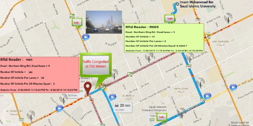
(IJACSA) International Journal of Advanced Computer Science and Applications,
                                                                                                         Vol. 9, No. 4, 2018

    Recent fast advancements in various technological fields       require data collection and are not intended for ubiquitous-
including hardware miniaturization, wireless communications,       oriented due to privacy required by minority group of people.
sensing devices and embedded computing allow for increasing
physical world with a unique identification; and also the              Riyadh city is the pioneer of smart city in Saudi Arabia
capabilities to analyze and process information to sense and       since 2008, when Riyadh Municipality began to implement
respond to the environment, thus making them smart. By             a smart street on Prince Muhammad Ibn Abdul-Aziz road
connecting smart objects to the internet, an Internet of Things    by providing a free wireless internet service for all residents
(IoT) is formed. The IoT is such a key in ICT that is rapidly      on this road through WiFi and WiMAX technologies [12].
becoming one of the most influential development and research      In 2013, Riyadh city is continuing its efforts by launching
topics, through enabling people and devices to communicate         smart roads that are developed to combine extensions of Oruba
with each other in real time. The IoT describes everyday           and Abu Bakr Al-Siddiq Street, and are centrally operated
physical objects connected with the internet and able to iden-     by a control room. It aims to guarantee the premium safety
tify themselves to other devices. It provides more advanced        standards for residents by offering dynamic message signs,
services to people through connecting several devices, systems     ventilation fans, and 58 centers for emergency calling, with
and applications beyond traditional machine-to-machine.            surveillance cameras along the tunnels, bells and alarms and
                                                                   escape doors between the tunnels with lighting [13].
     The concept of IoT is closely related to Radio Frequency           Authors in [14] develop a traffic information interface
Identification (RFID) as the way of communication and also         based on historic traffic data. It aims to show the drivers an
it may include other wireless or sensor technologies. RFID         output in public map as image processing of traffic speed
is shaping up to be an important building block for the            details of speed limit on the available routes with different
IoT. The affordable cost with improved benefits has made           colors by giving day and time limit information to help
RFID a reliable technology with a competitive advantage [3].       drivers make their choice in selecting a route or change
RFID is highlighted as one of the converging technologies          their current route for any kind of incident such as traffic
and main catalyst playing a significant role in this project.      congestion. The traffic speed data are collected on the basis of
Another reason is that RFID technology is considered as the        video analysis from several segment routes. Several videos are
most applicable for the country, such as in Saudi Arabia,          collected from each road segment, then each recorded video
where privacy is a big concern. The crowdsensing from user’s       is analyzed to measure the speed data. By using the data, an
smartphone [9] is getting more popular these days, however,        interface is developed to show the traffic conditions on public
it is argued that RFID is better in term of privacy as well as     map with speed limits denoted in different colors, which can
its support to the convergence of IoT [10].                        be a guideline for developing countries where navigation is
    This research proposes an intelligent traffic congestion       still unavailable. On the other hand, this method has many
framework for smart Riyadh city based on using the same            limitations. The main problem is that collecting many videos
infrastructure and the IoT services through identification of      is difficult and time consuming. Moreover, it does not provide a
vehicles causing congestion in specific regions. The physical      real time traffic information, only historical data are available.
basis of the framework is IoT, and realized computation                Authors in [15] propose a vehicle cloud computing archi-
and storage of services through a cloud computing platform.        tecture based on three IoT layers: device layer, communication
The objective of this project is to offer residents access to      layer and service layer. By using a cloud computing technique,
road information and detecting traffic congestion by providing     three layers enable devices, network and services to exchange
them automated services such as counting vehicle service,          information with each other in a real-time manner. Combining
video streaming service, dynamic message signs service and         devices with cloud computing technologies allows essential
alternative routes in real-time. Business Process Execution        services to be offered to residents.
Language approach (BPEL) is proposed to integrate more than
one service in one model publicly available for residents.             It is observed that almost all the previous researches and
BPEL is a XML-based language used to define business               studies that talked about IoT frameworks focus only on three
processes’ workflow to unify the format of business process        or more essential layers, but each researcher names the layer
flow definition. By using BPEL technology, the proposed            differently. To date, the integration layer that can be used for
services are integrated with the existing Riyadh services such     integrating the services of IoT is not available yet. Therefore,
as public map and CCTV services to offer the users a new           BPEL tool is used to effectively collaborate and integrate
service which is a traffic congestion service.                     several existing and new services with each other by defining
                                                                   a business workflow for each service in one BPEL model.
                                                                   Moreover, by using the BPEL tool the technical team can then
                   II.   R ELATED W ORKS                           easily develop several applications due to the visibility of any
                                                                   possible workflows amongst available service.
    A particular IoT service is useful to make applica-
tion development and implementation in agile manner. Au-                       III.   T RAFFIC C ONGESTION F RAMEWORK
thors in [11] categorize IoT services into four categories,
which are identity-based services, data collection services,           Riyadh city should benefit from internet and communi-
collaboration-supported services, and ubiquitous-oriented ser-     cation technologies to provide smart roads in order to have
vices. Generally, IoT development starts from data collection to   more confidence and reliable services. The ability to know the
collaboration-supported and ubiquitous-oriented. However, not      traffic conditions on the road ahead via effective services on
all services of IoT necessarily develop to the stage of ubiqui-    the mobile devices allows residents to find out the number
tous convergence because some applications and services only       of vehicles on a specific road, display live video streams
                                                       www.ijacsa.thesai.org                                         293 | P a g e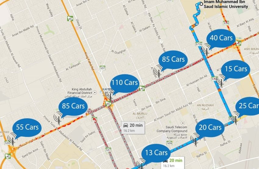
(IJACSA) International Journal of Advanced Computer Science and Applications,
                                                                                                                   Vol. 9, No. 4, 2018

captured from CCTV cameras, view warning messages on                         of different services to be presented to residents, which are
DMS and find alternative routes. This eventually leads to the                vehicle counting service, live video streaming service, dynamic
reduce of time consuming and vehicle’s fuel consumption.                     messages signs service and alternative rerouting service.
Moreover, the DMS boards on the roads display warning
messages automatically to residents. The more residents utilize
these services, the more traffic congestion decreases and the
more residents are confident and satisfied.
    The proposed traffic congestion framework contains a
fixed and mobile platform including the support of sensors
mounted on vehicles. The sensor devices collects data and
transfers it to cloud via the internet to offer new services to
residents. More specifically, Fig. 1 shows the layers of the
proposed traffic congestion framework for Riyadh city. This
proposed framework consists of four different layers that have
different purposes: a physical layer, a communication layer, an
integration layer and an application layer.

                                                                             Fig. 2. Traffic congestion architecture for smart riyadh city based on IoT
                                                                             services.

                                                                                 To achieve an effective traffic congestion control system in
                                                                             Riyadh, both RIFD technology and CCTV devices are used.
                                                                             RFID technology provides automatic recognition of vehicles
                                                                             with the tags, RFID tags transfer the signal containing the tag
                                                                             number captured by RFID reader. For this approach, vehicles
                                                                             should be installed with RFID tags; whenever the vehicle
                                                                             reaches the specified range of RFID readers, the RFID reader
                                                                             is able to read the information of each vehicle’s tag. The stored
                                                                             information in the RFID tag for each vehicle can only be a
                                                                             unique tag number while the location coordinates and time-
                                                                             stamp is in the RFID reader. The location coordinates should
                                                                             be integrated into the RFID reader through the built-in GPS
                                                                             sensor to provide information regarding where a vehicle tag
                                                                             has been interrogated and at what time. The microcontroller
                                                                             in the RFID reader is programmed to calculate the exact time at
                                                                             which the tag ceases to be read and then link the time with the
                                                                             location coordinate of the RFID reader. On the other hand, the
                                                                             CCTV video surveillance cameras that are installed on Riyadh
                                                                             roads is able to take images or recordings for surveillance to
                                                                             monitor the traffic congestion through the monitoring screen
                                                                             in the traffic department center. This research uses the already
Fig. 1.   Conceptual traffic congestion framework for Riyadh City.           installed CCTV cameras through Everything as a Service
                                                                             (XaaS) technology to get the live video of each road to also
    An architectural view of the framework is shown in Fig. 2.               be displayed to residents.
The bottom layer is called the physical layer, whose function
                                                                                 The information trunk for the IoT is a communication layer.
is recognizing and collecting data of vehicles through RFID
                                                                             The communication layer provides the connection between the
technology and CCTV cameras systems. When data are pooled
                                                                             physical devices of RFID readers and CCTV and the cloud
synchronously, transmission is required on second layer, which
                                                                             through the internet. The layer makes use of 3G, 4G, LTE,
is called a communication layer. The formation of network
                                                                             fiber optic or WiFi networks to transfer the RFID data and
in the communication layer consist of wireless technologies
                                                                             video data to the cloud storage in application layer. These
such as 3G, 4G, LTE or WiFi. This layer is responsible for
                                                                             communication technologies generally characterized by high
transmitting data with high reliability and security to cloud
                                                                             reliability and high transfer rates.
storage. The third layer is an integration layer. BPEL is used
in this layer to design the workflow process of each service                     In integration layer, BPEL tool is used to display a work-
on the traffic congestion framework. BPEL is proposed to                     flow for integrating more than one service with each other.
integrate several services with each other to build composite                Because more than one service is combined with another
service; when more than one service is combined together                     service in one BPEL model, the users have a new service at
in one BPEL model, then residents have a new service. The                    the end of the model. Each service should be able to achieve
top of the framework is an application layer which consists                  automation of process by defining a workflow of activities
                                                                 www.ijacsa.thesai.org                                               294 | P a g e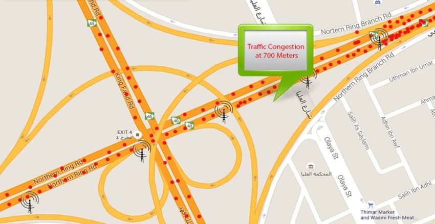
(IJACSA) International Journal of Advanced Computer Science and Applications,
                                                                                                           Vol. 9, No. 4, 2018

which is called a business process. A business process is           boards service in the roads that relied on IoT also benefits
defined as a set of all possible sequences of activities for        residents to get reliable and real-time warning messages.
delivering a specific business objective, and business process of
services is often modeled and performed through BPEL. The           A. Vehicle Counting Service
BPEL model is a language used to define how the business
processes involving web services are combined and executed              The objective of Vehicle Counting Service is to display
in smooth manner. Each notation represents a specific activity      the exact number of vehicles in a specified street for one lane.
in the process. Fig. 3 presents the notations legend used in        It also displays the average number of vehicles for a specific
Eclipse BPEL designer and executed with Active BPEL Engine          period of time to detect the exact traffic congestion. There are
for traffic congestion framework.                                   two ways to achieve this objective. One is to use the BPEL
                                                                    model to identify the workflow of this service. The other is to
                                                                    develop a proposed vehicle counting web-based application.
                                                                        BPEL model is used to combine street sensor services
                                                                    RFID internet service and user defined map service to become
                                                                    one service which is vehicle counting service by defining a set
                                                                    of activities for the service. The RFID readers in the roads are
                                                                    supposed to receive RFID tag information from each vehicle
                                                                    equipped with the RFID tag. The received information from the
                                                                    RFID tags and reader is then transferred through the internet
                                                                    to the cloud storage. The stored information is the tag number
                                                                    of each vehicle, location coordinates and time-stamp. Based
                                                                    on this information, it is possible to identify the location of
Fig. 3.   BPEL Notations for the Framework.                         each vehicle and the time when it crossed the RFID readers
                                                                    in the roads. The application in cloud is able to retrieve this
    The goals of using BPEL models in the framework are:            information from the cloud storage to calculate and identify
    •      To define the business processes by using XML lan-       how many vehicles per lane are congested in a specific RFID
           guage.                                                   reader range installed on the roads and the average number of
                                                                    the traffic congestion for a specific period of time. Once the
    •      The BPEL layer clearly represents the flow of each       user connects to internet, the result of the congested vehicles
           service such as vehicle counting service, CCTV live      in a specific RFID reader is received through the proposed
           streaming service, rerouting service and DMS service     mobile application and integrating with the public map service
           in a graphical representation.                           for displaying to residents the average and exact number of
                                                                    vehicles per specific time in the congested area on public map.
    •      BPEL has multiple graphical notations to show how
           the business process works and allow their use to be         A web-based application is developed which is used by
           blended as seamlessly as possible, such as combin-       Riyadh residents to assess the actual number of vehicles at
           ing multiple services to one, therefore residents can    each RFID reader for one lane in addition to the average
           choose the desired services from cloud without having    number of vehicles for a specific period of time to detect the
           prior knowledge about the application development.       traffic congestion. The heavily congested roads are almost the
                                                                    result of bottlenecks; these bottlenecks are frequently due to
    •      BPEL is able to combine multiple services in one         the junctions, accidents, reduced number of lane or reduced
           service such as combining RFID service with the          carriage way width. Based on the previous researches, it is
           internet service and public map service to get vehicle   noticed that most of researchers are stated several metrics to
           counting service.                                        measure the traffic congestion such as average traffic speed
    •      The developers can easily develop applications and       [16], intensity and density [17]. This research proposes vehicle
           services by using the BPEL model XML code to             counting web-based application to calculate and measure the
           create database modeling from where non developer        congestion of roads based on three important measures: the
           end users can benefit.                                   number of vehicles within RFID tags read by one RFID reader,
                                                                    the exact number of vehicles at each RFID reader based on
    The application layer in the top of the framework provides      the number of lanes, and the average number of vehicles per
several services to residents to complete data processing, data     lane during a certain period of time by each RFID reader.
exchange, data calculation and data storage. The cloud storage
in this layer stores RFID tags, RFID readers’ data and video        B. Vehicle Counting Web-Based Application
data. The cloud is considered as XaaS and used to provide
services in the application layer, hence, residents can access          The presented web-based application is developed by using
the cloud to choose their required services from their mobile       Microsoft SQL server and ASP.net programming language,
devices. There are four proposed services: vehicle counting         which is a server side web application development struc-
service, CCTV live streaming service, dynamic messages signs        ture that was generated for the web creation to develop dy-
service and alternative rerouting service. These services can       namic web pages with Hyper-Text Markup Language (HTML),
be executed from a mobile application to benefit residents in       JavaScript and Cascading Style Sheet (CSS) to design the user
detecting traffic congestion on Riyadh roads and then reducing      interface. The vehicle counting service application is simulated
the congestion costs as general. Moreover, the proposed DMS         by using ASP.net in visual basic (VB.net) and Microsoft SQL
                                                        www.ijacsa.thesai.org                                        295 | P a g e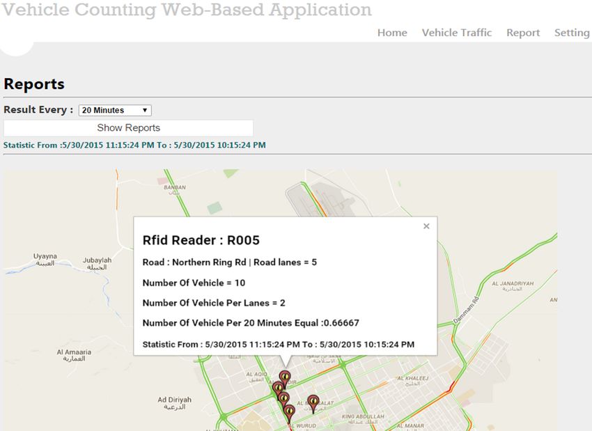
(IJACSA) International Journal of Advanced Computer Science and Applications,
Vol. 9, No. 4, 2018
server database. Hence, the data are stored in the database.
Moreover, by using public map API, the vehicle counting
web-based application data are connected with the public map.
The API can be retrieved from the provider by using an API
key and then integrate it with the web-based application. The
application interface is shown in Fig. 4.
Fig. 5. Vehicle traffic page in vehicle counting web-based application.
combines the CCTV service, the internet service and user
defined map service (in this research, public map service is
utilized) to provide residents map-based video live stream
service. The BPEL model also displays the workflow process
of the CCTV live streaming service.
Fig. 4. Setting page in vehicle counting web-based application. The CCTV cameras that are installed along Riyadh roads
are connected to the internet to store the received video data
There are three tables in the setting page. The information in the cloud storage, then the same video data are streamed
in the tables is stored in database as inputs. The first table is from the cloud to residents by using an application to view the
for adding Riyadh roads on the public map. A user can insert live streaming video of the desired road. Once video data are
new road by filling the following information: Road ID, Road received, public map is invoked to display the CCTV locations
Name, Road Latitude, Road Longitude, Number of lanes in on the roads. Then, residents choose the desired location that
each road and Notes. The second table is for adding the RFID has CCTV cameras and finally residents are able to view and
Readers in Riyadh Roads by filling the RFID Reader Name, display the live streaming of the chosen road.
Latitude and Longitude of this reader and the Road that want
to add this RFID reader to it. Finally, the last table is for adding D. Dynamic Messages Signs (DMS) Service
vehicles which represent by the vehicle tag ID for each one.
The inputs are stored in the database, and then this information Some roads in Riyadh city have DMS boards displaying
is retrieved back through ASP.net with the integration of public warning messages regarding the traffic status to residents. It
map API services to give the output to Riyadh residents. is the responsibility of the traffic department to update the
messages based on CCTV system. Residents are unable to
In Fig. 5, the vehicle traffic page aims to insert vehicle get real-time information because the DMS is not updated
tag to particular RFID reader. In other words, the RFID reader automatically. BPEL is able to combine street sensor services
reads the tag information for each vehicle that passes along (RFID), internet services and public map service in one model.
the road. Each vehicle tag is inserted to one of the defined
RFID reader in setting page. Once the vehicle tag is added IoT is proposed to connect the DMS to the internet and
to particular RFID reader, the detailed table is shown in the then the dynamic message board is able to provide real-time
vehicle traffic page. This table contains the information of messages to residents who are travelling on the roads. The
RFID reader and roads. It displays the exact date and time DMS is completely controlled by an application itself and the
when the RFID reader and vehicle tag are inserted. information is retrieved from cloud storage based on the RFID
readers’ information, not from updating the DMS application
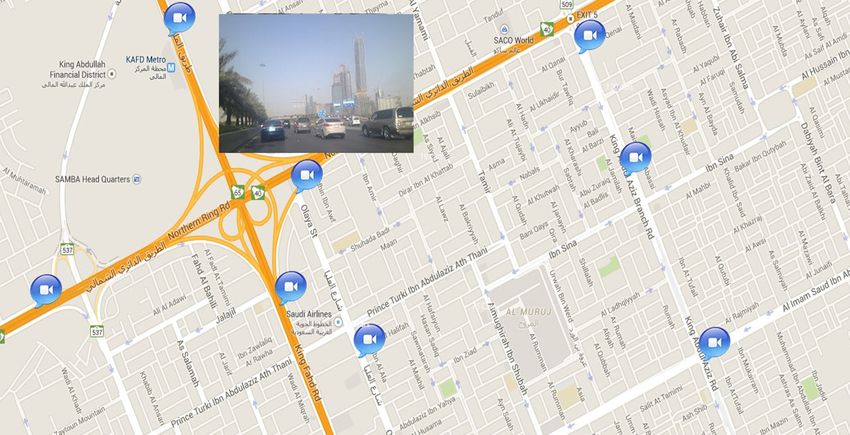
C. CCTV Live Streaming Service manually through the monitoring of the traffic department to
CCTV cameras. The RFID readers installed on the roads are
The current CCTV system in Riyadh city is used for the able to receive the installed RFID tags information from the
video surveillance of roads that is accessed only by the traffic vehicles. A DMS application in the cloud retrieves only the
department. A traffic department employee should see the RFID readers’ information that is placed after the DMS from
status of the roads and then assign a traffic policeman to a the cloud storage to compare which RFID reader shows the
specific site to manage the traffic congestion or any other most congestion and then an automated warning message is
services but this method is not of much use to the Riyadh displayed on the DMS board on the roads to residents. Since
residents. This research project improves the performance of the availability of the internet for DMS on roads and on users’
the current CCTV monitoring system by allowing access a mobile applications, residents are now able to see warning
live streaming video service to residents. The BPEL model messages about any congestion via a DMS board on the road
www.ijacsa.thesai.org 296 | P a g e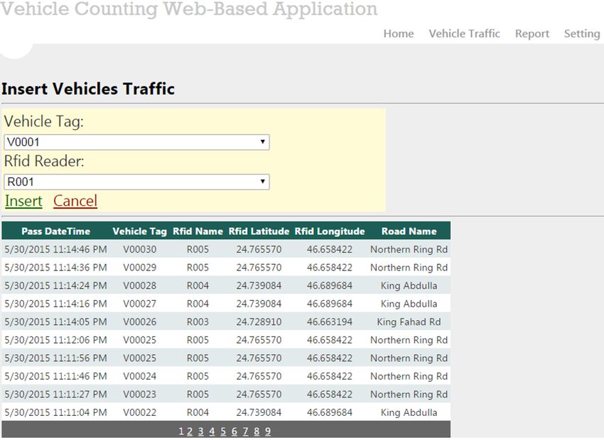
(IJACSA) International Journal of Advanced Computer Science and Applications,
                                                                                                            Vol. 9, No. 4, 2018

and also via public map on a mobile application, in addition               The service starts with receiving a request, which then
to receiving any warning messages from the traffic department          invokes the vehicle counting service to begin the processes. By
regarding to weather effects, accidents and others.                    assuming there is a flow of readers on the roads, and taking
                                                                       one RFID reader in the Northern Ring Road and another in
E. Alternative Rerouting Service                                       the King Fahad Road, both RFID readers read the vehicle’s
                                                                       information from the RFID tags that the vehicles on the roads
    In alternative rerouting service, if there is traffic congestion   are equipped with and assigned a RFID tag’s information
on some roads, the service gives residents an alternative road         to each RFID reader; the RFID readers on the two roads
based on the real-time information of the RFID data. BPEL              then assign the information from the RFID readers as tag
combines the sensor street service, the internet service and           numbers, location coordinates and time-stamps to the cloud
public map service in one model to act as one service, which           storage by invoking the internet service. The application in the
is a rerouting service.                                                cloud retrieves the RFID readers’ information to calculate the
    The RFID readers read the RFID tag information from each           number of tags for each RFID reader. Then, resident invokes
vehicle equipped with the RFID tag. The received information           the internet service to connect with the mobile application to
is transferred through the internet to cloud storage. The alter-       receive the RFID reader’s values from the cloud. Once the
native rerouting application in cloud compares the congested           values are received, the public map API service is invoked
vehicle data of the nearest RFID readers to the congested road         to retrieve the maps from the cloud and then the retrieved
and then the application stores the least congested value of           RFID reader’s values are assigned to the map. Finally, the total
the road. Thus, users can open the application and connect to          number of vehicles are indicated to residents on the public map
the internet service to receive the value of the least congested       for each reader.
road. Public map is also required to be invoked, so that the
                                                                           The developed web-based application for vehicle counting
application provides the users with the least congested road as
                                                                       was built to display on public map the actual number of
a rerouted road for residents, visually available on the map.
                                                                       vehicles per specific minutes in one hour and in one lane for
                                                                       each RFID reader. Overall, the application operated well and as
F. Traffic Congestion Service                                          intended. The Vehicle Counting Web-Based Application is able
    The traffic congestion service combines the vehicle count-         to provide the result from the inputs of RFID readers, Roads
ing service, CCTV live streaming service, dynamic messages             and the Vehicle tags. Hence, the inputs data are combined to
signs service and rerouting service together in one BPEL               give the output. Fig. 7 shows the number of vehicles per lane
model. These services are available to Riyadh residents from           in addition to the average number of vehicles per specific time
the mobile applications on a public map at any time and from           of period based on resident’s preferences. The user preference
anywhere in Riyadh by XaaS, in addition to the DMS boards              is the key concept of XaaS as coined in [18].
that are installed on Riyadh roads that give real-time warning
                                                                           From report page, resident can choose specific time in hour
messages. These valuable services benefit residents by detect-
                                                                       to display the average number of vehicles per lane either in five
ing real-time information on traffic congestion, thus saving
                                                                       minutes or above. As each vehicle is mapped to RFID reader,
valuable time, and warning residents about traffic congestion
                                                                       the equations are executed to get the traffic congestion results.
in a specific location, thus enabling resident to easily choose a
                                                                       Once resident chooses show reports menu, the public map is
recommended alternative route to avoid the traffic congestion.
                                                                       displayed to resident. The location of RFID readers are marked
BPEL is used to combine the proposed and existing services
                                                                       in red icon. Then, the user can zoom in the map to choose
in one model to act as one service.
                                                                       the desired reader of specific road and click on it. The pop-
                                                                       up screen appears with the name of reader, road, road lanes,
       IV.   T RAFFIC C ONGESTION S ERVICE M ODELS                     actual number of vehicles in any lanes, number of vehicles
    The BPEL model shows a list of the activities of each              per one lane and the average number of vehicles per specific
service. Residents can benefit from choosing their desired             period of time. Through these information, resident can view
services from the cloud; the application can be developed              the congested road for each RFID reader and detect the traffic
by the developers with reference to the BPEL models for                congestion.
the benefit of both the traffic department and residents of
Riyadh. Although BPEL is a modelling language, the user can            B. CCTV Live Streaming Service BPEL Model
design their models by using an interactive any graphical BPEL
designer tool and then execute the model by instantiating                  A CCTV live streaming service BPEL model is shown in
abstract services in the model with concrete available services.       Fig. 8. This model shows a list of activities that should be
Hence, there is no programming task required to execute                followed to apply this service to achieve the goal of a live
the BPEL models, especially if concrete services are already           streaming service to residents. Hence, residents are able to see
available.                                                             the live video status of the chosen roads in Riyadh roads.
                                                                           The CCTV live streaming service is invoked to get the
A. Vehicle Counting Service BPEL Model
                                                                       result of the CCTV video footage on public map. By assuming
    A vehicle counting service BPEL model is shown in Fig. 6.          there are two CCTV cameras processed in parallel, one in
The model shows the list of activities that should be followed         Northern Ring Road and another one in King Fahad Road,
in each service to assess the number of vehicles congested in          both cameras take live videos of the roads and the video data
a specific road per every lane as well the average number of           are assigned to the CCTV in the same road. After the CCTV
vehicles for a specific period of time.                                video data have been received, it is assigned to the cloud
                                                          www.ijacsa.thesai.org                                          297 | P a g e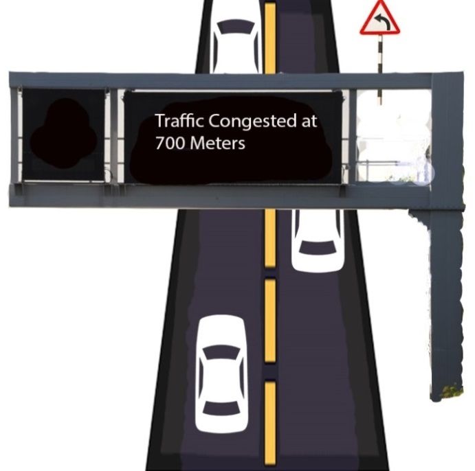
(IJACSA) International Journal of Advanced Computer Science and Applications,
                                                                                                           Vol. 9, No. 4, 2018

Fig. 6.   Vehicle counting service BPEL Model.

storage by invoking the internet service. The video data from      about the traffic congestion status on the roads.
the cloud storage are retrieved by invoking the internet service
from resident to connect with the mobile application. Once the         The model starts with invoking the Dynamic Messages
video data are received, the public map API service is invoked     Signs Service. By assuming there are three parallel RFID
to retrieve the maps from the public cloud, then the video data    readers after the DMS board in the Northern Ring Road,
and map data are combined together to show the location of the     these readers read the tag information for each vehicle that
CCTV cameras installed on the roads of Riyadh. Accordingly,        passes along the northern ring road and assign each RFID
residents can choose the CCTV cameras of the needed location       tag information to the RFID reader. The three RFID readers
from public map. The desired location of CCTV is assigned to       then assign the RFID information to cloud after invoking the
public map and finally, the mobile application is able to give a   internet service. A DMS application in cloud is programmed
pop-up screen to show the live stream of the video data for the    to receive the information of the RFID readers that is installed
chosen road. The output of the CCTV live streaming service         after the DMS from the cloud storage and then identify the
model is shown in Fig. 9.                                          congestion of vehicles by comparing the results of each RFID
                                                                   reader’s information. For example, Northern Ring Road RFID
                                                                   Readers (2) and (3) are placed after the DMS board. Northern
C. Dynamic Messages Signs Service BPEL Model                       Ring Road RFID Reader (2) has 30 vehicles and Northern
                                                                   Ring Road RFID Reader (3) has 100 vehicles. The highest
    A dynamic messages signs service BPEL model for the            number of vehicles in the two RFID readers are identified by
Dynamic Messages Signs (DMS) in roads and mobile appli-            the application and considered as more congested, which is
cation are shown in Fig. 10. The BPEL model shows a list           Northern Ring Road RFID Reader (3).
of activities that should be followed to apply these services
to achieve the goal of displaying real-time warning messages           The DMS board on the road and the mobile application
                                                       www.ijacsa.thesai.org                                        298 | P a g e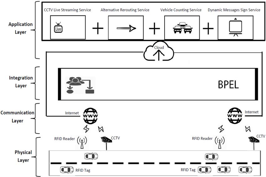
(IJACSA) International Journal of Advanced Computer Science and Applications,
                                                                                                              Vol. 9, No. 4, 2018

                                                                      Fig. 9.   CCTV live streaming service output.

                                                                      residents can get warning messages about congestion or any
                                                                      updated status regarding traffic problems from the roads and
Fig. 7.   Vehicle counting service output.                            from the mobile application. Unlike the existing DMS in
                                                                      Riyadh, the DMS in the framework can also be accessed by any
                                                                      user’s device, since XaaS technology is utilized. The output of
                                                                      the dynamic messages signs service on roads is shown in Fig.
                                                                      11, while the output of the dynamic messages signs service in
                                                                      mobile application is in Fig. 12.

                                                                      D. Alternative Rerouting Service BPEL Model
                                                                          An alternative rerouting service BPEL model is shown in
                                                                      Fig. 13. This model shows a list of activities that should be
                                                                      followed to apply the service to achieve the goal of providing
                                                                      residents an alternative route that is not congested.
                                                                          The alternative rerouting service is invoked to identify the
                                                                      least congested route. Assuming there are three RFID readers:
                                                                      in Northern Ring Road, King Fahad Road and King Abdullah
                                                                      Road. These readers read the tag information for each vehicle
                                                                      that passes them and then each RFID tag’s information is
                                                                      assigned to the RFID reader. After that, the three RFID
                                                                      readers assign the RFID tag’s information to cloud storage
                                                                      after invoking the internet service to store this information in
                                                                      cloud storage. The alternative rerouting application in the cloud
                                                                      receives the RFID reader’s information, then the congestion
                                                                      comparison is taken to identify the lowest number of RFID
                                                                      tags, for example the RFID reader in Northern Ring road re-
                                                                      ceives 300 RFID tags while the RFID reader in King Abdullah
                                                                      road receives 58 RFID tags. The lowest one, King Abdullah
                                                                      road, is chosen through this application and the rerouting path
                                                                      is identified as King Abdullah road. When resident invokes
                                                                      the internet service, then the mobile application receives King
                                                                      Abdullah road information from the cloud, then public map
                                                                      is invoked to retrieve the maps from public cloud and King
                                                                      Abdullah road information is assigned to the map. Hence,
Fig. 8.   CCTV Live Streaming Service BPEL Model.                     residents are notified by the mobile application to reroute to the
                                                                      least congested road to reach their needed location without any
                                                                      congestion. The output of the Alternative Rerouting service
must connect to the internet to receive the Northern Ring Road        model is illustrated in Fig. 14.
RFID Reader (3) information as the highest congested reader
from the cloud. An automated message is displayed on the              E. Traffic Congestion Service BPEL Model
DMS board on the roads after assigning the Northern Ring
Road RFID reader (3) data to the DMS, while the warning                   A Traffic Congestion Service BPEL model shows the list
message in the mobile application appears to the users after          of activities that should be followed to combine the proposed
invoking the public map service and assigning the Northern            services with each other in one BPEL model (it is not shown
Ring Road RFID reader (3) data to the map. Thus, Riyadh               due to the limitation of the page). As the proposed services
                                                          www.ijacsa.thesai.org                                         299 | P a g e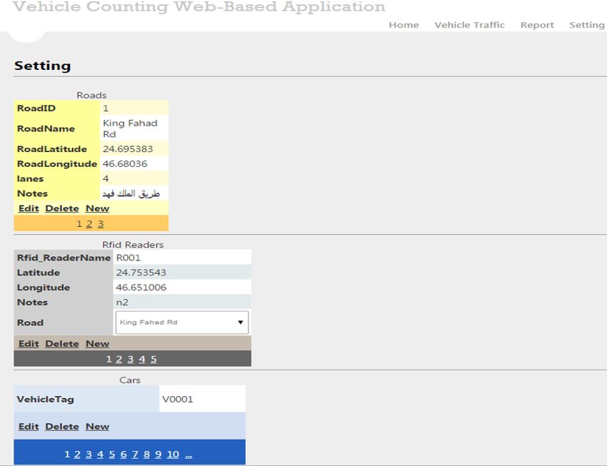
(IJACSA) International Journal of Advanced Computer Science and Applications,
                                                                                                               Vol. 9, No. 4, 2018

Fig. 10.   Dynamic messages signs service in roads BPEL Model.

are in cloud as a service, residents can choose any service they             The returned values from the cloud are combined with the
need from public map in the proposed mobile application or                   public map API to get the output of services in one application.
from the DMS in the roads. The appropriate output of each                    Hence, residents are able to choose their desired services from
service is given through the application layer.                              the proposed mobile application. Furthermore, the returned
                                                                             RFID reader’s values from the cloud are also used for the
    The physical devices in traffic congestion service model                 DMS on the roads. Residents have the option to use the mobile
comprises RFID and CCTV cameras. The RFID sensors ser-                       application or the DMS boards on Riyadh roads.
vices can be used to access the output of the received RFID
tags, and is used by the following three services: Vehicle                       In Fig. 15, the traffic congestion service starts with receiv-
Counting, Dynamic Messages Signs and Alternative Rerouting                   ing a request, and then invokes the traffic congestion service
services. The output of RFID services is stored in cloud                     to initiate the processes to work. In this traffic congestion
storage. Similarly, the CCTV cameras that are installed on                   service model, there are two physical devices: RFID and
Riyadh roads are able to retrieve the video data of each road                CCTV devices. Both of them are accessed in parallel by
and then store it in cloud storage. Each application on the cloud            using the flow activity. RFID services start by assuming there
is designed depending on each service and is able to retrieve                are two RFID readers, one in Northern Ring Road and the
the needed data from the cloud storage and then process it.                  other in King Abdullah Road. The readers read the vehicle’s
                                                                 www.ijacsa.thesai.org                                         300 | P a g e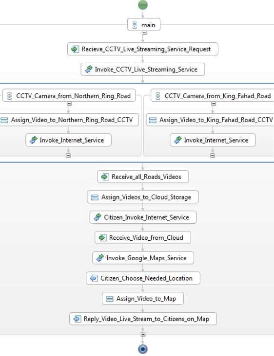
(IJACSA) International Journal of Advanced Computer Science and Applications,
                                                                                                              Vol. 9, No. 4, 2018

                                                                      from ordered activities, starting by receiving the video data
                                                                      and then assigning them to the CCTV application. Thirdly,
                                                                      the dynamic messages signs application aims to display some
                                                                      warning messages on the DMS boards. This application in
                                                                      cloud is programmed to receive only the RFID reader’s infor-
                                                                      mation located after the DMS board from the cloud storage
                                                                      and then identify the congestion of vehicles by comparing the
                                                                      results of each RFID reader.
                                                                          When there are two RFID readers in Northern Ring Road,
                                                                      the Northern Ring Road RFID reader (2) tagged 55 vehicles
                                                                      and the Northern Ring Road RFID reader (3) tagged 110
                                                                      vehicles, the DMS application compares them and the highest
                                                                      RFID reader which is Northern Ring Road RFID reader (3) is
                                                                      assigned to the DMS application and considered as the more
                                                                      congested reader. Lastly, the alternative rerouting application
                                                                      in the cloud aims to enable Riyadh residents to take another
Fig. 11.   Dynamic messages signs service output.
                                                                      path to avoid road congestion. This application starts with
                                                                      receiving the RFID readers’ information from cloud storage.
                                                                      By assuming there are two RFID readers, one in Northern Ring
                                                                      Road and the other in King Abdullah Road. The application
                                                                      is programmed to compare them and take the lowest number
                                                                      of RFID tags in each RFID reader - for example, the RFID
                                                                      readers in Northern Ring road receive 300 RFID tags and the
                                                                      RFID readers in King Abdullah road receive 33 RFID tags.
                                                                      The lowest one which is in King Abdullah road has the data
                                                                      assigned to the alternative rerouting application.
                                                                          The output from each application in the cloud is processed
                                                                      in a parallel way based on the requests from the users. When
                                                                      the users need to see the warning messages of DMS boards on
                                                                      the roads, the DMS board must invoke the internet service to be
Fig. 12.   Messages Signs service output.                             able to receive RFID readers’ data from the DMS application.
                                                                      The DMS receives the Northern Ring road RFID reader’s (3)
                                                                      information as the more congested area, therefore it assigns
information from the RFID tags which the vehicles on the              this information to the DMS board and then the application
road are equipped with and then the flow of RFID information          displays a warning message on the board to the users that
is assigned to the reader. Then, Northern Ring Road RFID              there is congestion in this area.
reader and King Abdullah Road RFID reader assigns their
information as tag numbers, location coordinates and time-                Regarding the proposed mobile application in the users’
stamps to cloud storage by invoking the internet service. The         devices, it has four proposed services that benefit Riyadh
second service is CCTV services, responsible for getting the          residents by identifying and detecting traffic congestion on
live video of Riyadh roads. By assuming in one flow there are         Riyadh roads. If residents need to access the proposed mobile
two CCTV cameras, one in Northern Ring Road and another               application, their application must invoke the internet service
in King Abdullah Road, both cameras take live videos of each          to be able to display the proposed services. Then, the mobile
road and then the video data are assigned to the CCTV camera          application receives the processed RFID and video information
in the same road. The flow of the CCTV video data is assigned         from the cloud. The application also invokes public map
to cloud storage by invoking the internet service.                    to retrieve the data and services from the public cloud and
                                                                      integrate them with the processed RFID and video data from
    The RFID and CCTV video data are stored in cloud                  the cloud. The services are processed in parallel to respond
storage. From the cloud, each application carries out its func-       to residents’ requests and the values of services are assigned
tionality to give an appropriate service. The proposed services       to the map. Hence, the proposed services are shown on the
are processed in parallel, therefore it is required to use the flow   map to enable Riyadh residents to choose and display one
activity to explain the process of each service.                      or more than one service at the same time, such as number
                                                                      of vehicles at each RFID reader, warning messages on the
    Firstly, the vehicle counting service as an application in
                                                                      DMS boards, alternative rerouting. Additionally, residents can
cloud processes a list of activities in ordered sequence. The
                                                                      choose the CCTV cameras of the needed location to view a live
vehicle counting service receives the Northern Ring Road
                                                                      stream of the road. Finally, residents’ traffic congestion service
RFID information and King Abdullah Road RFID Reader in-
                                                                      request is replied to, since XaaS technology is utilized.
formation from the cloud storage to initiate the processing and
calculating of the average number of RFID tags during specific
                                                                                    V.   Q UANTITATIVE E VALUATION
period of time for each RFID reader and then assign the
average number of vehicles for each RFID reader. Secondly,                A quantitative experimental correlational study was de-
the CCTV live streaming application in cloud is composed              signed to measure the impact of this research. The population
                                                          www.ijacsa.thesai.org                                         301 | P a g e
(IJACSA) International Journal of Advanced Computer Science and Applications,
Vol. 9, No. 4, 2018
Fig. 13. Alternative rerouting service BPEL Model.
of this study is Riyadh adult users of internet connected a low standard deviation meaning that there are only small
devices. To evaluate the usability of the research, a ten-item differences between the participants’ answers. This result can
questionnaire was randomly devised and distributed to seventy be used to roughly identify the central tendency and the outlier
participants, who willingly decided to take part in the survey. of the observed data.
The participants were provided with a list of service output
images. The participants were required to answer the following VI. C ONCLUSION
ten questions on a scale from 1 to 5 where 1 - Not at all, and
5 - To a large extent. Table I shows the results of the survey The traffic congestion framework of Riyadh city is pre-
distributed amongst students and staff for a set of 70 surveyed sented to improve Smart Riyadh City. XaaS is considered
actors. For example, Q2 has a mean score of 4.02 showing as an appropriate approach used in the framework due to
that; overall, participants rated the Fig. 9 as highest. Most of enhance the public services and increase transparency between
the participants gave a score about 4 to all questions with traffic department and residents. XaaS approach advances
the framework through BPEL models which are useful for
www.ijacsa.thesai.org 302 | P a g e(IJACSA) International Journal of Advanced Computer Science and Applications,
Vol. 9, No. 4, 2018
TABLE I. S UMMARY OF THE R ESULTS OF THE C ONDUCTED S URVEY
from the DMS boards that installed on the roads. As BPEL
supports the workflow process to combine atomic services,
Questions Mean Std Dev.
Q1. After you use the Vehicle Counting Service, do you like the 3.38 0.957 one BPEL model is designed to combine any IoT services. A
service output (Fig. 7)? quantitative evaluation was conducted to measure the usability
Q2. After you use the CCTV Live Streaming Service, do you 4.02 0.885 impact of the research to residents. The future work includes
like the service output (Fig. 9)?
Q3. After you use the Messages Signs Service, do you like the 3.91 0.940 a stronger comparison analysis between the proposed models
service output (Fig. 12)? by measuring quality of service metrics as key performance
Q4. After you use the Alternative Rerouting Service, do you like 3.82 1.065
the service output (Fig. 14)?
indicators and covering more roads in Riyadh.
Q5. After you use the Traffic Congestion Service, do you like 3.61 1.175
the service output (Fig. 15)?
Q6. The message is easy to understand. 3.83 0.814
ACKNOWLEDGMENT
Q7. The message is useful during a traffic jam. 4.28 0.696
Q8. I would use the system once it is deployed. 4.08 0.790 This work was supported by the Deanship of Scientific
Q9. It is a good idea to use those maps as an emergency guide. 3.98 0.690 Research (DSR), King Abdulaziz University, Jeddah, Saudi
Q10. The provided information is enough. 3.88 0.725 Arabia. The authors, therefore, gratefully acknowledge the
DSR technical and financial support.
R EFERENCES
[1] Institute of Public Administration. (2015) Traffic congestion.
[2] A. Al-Sibai. (2011) Bottleneck traffic creates a heavy loss of sr81
billion.
[3] F. Al-Naima and H. Hamd, “Vehicle traffic congestion estimation based
on rfid,” International Journal of Engineering Business Management,
pp. 1–8, 2012.
[4] C. Campolo, A. Iera, A. Molinaro, S. Paratore, and G. Ruggeri,
“Smartcar: An integrated smartphone-based platform to support traffic
management applications,” Vehicular Traffic Management for Smart
Cities (VTM). IEEE, 2012, pp. 1–6.
[5] Grand View Research. (2014) Intelligent transportation system (its)
market analysis and segment forecasts to 2020.
[6] Dornier Consulting and Rapp Trans, “Its deployment and integration
plan for saudi arabia,” Tech. Rep., 2011.
[7] C. Turcu, V. Gaitan, and C. Turcu, “An internet of things-based dis-
tributed intelligent system with self-optimization for controlling traffic-
Fig. 14. Alternative rerouting service output. light intersections,” Applied and Theoretical Electricity (ICATE), 2012
International Conference. IEEE, 2012, pp. 1–5.
[8] D. D. Romero, A. S. Prabuwono, A. Hasniaty et al., “A review of
sensing techniques for real-time traffic surveillance,” Journal of applied
sciences, vol. 11, no. 1, pp. 192–198, 2011.
[9] M. Heiskala, J.-P. Jokinen, and M. Tinnilä, “Crowdsensing-based trans-
portation services-an analysis from business model and sustainability
viewpoints,” Research in Transportation Business & Management,
vol. 18, pp. 38–48, 2016.
[10] D. Singh, G. Tripathi, and A. J. Jara, “A survey of internet-of-things:
Future vision, architecture, challenges and services,” in Internet of
things (WF-IoT), 2014 IEEE world forum on. IEEE, 2014, pp. 287–
292.
[11] M. Gigli and S. Koo, “Internet of things: Services and applications
categorization,” Scientific Research Journal, pp. 27–31, 2011.
[12] Riyadh Municipality. (2008) Altahliah’s street is the first smart city
Fig. 15. Traffic congestion service output. application in saudi arabia.
[13] High Commission for the Development of Arriyadh. (2014) Extension
of abu bakr al-siddiq and oruba street through the air base.
business managers and developers to provide a complete traffic [14] S. Chowdhury, B. Haque, and G. Sarwar, “Traffic information interface
congestion system for Riyadh city to offer their residents development,” Transport and Telecommunication Journal, pp. 91–96,
effective services. The proposed traffic congestion service are 2014.
vehicle counting service, which is proposed to detect the total [15] R. Wang, L. Zhang, R. Sun, J. Gong, and L. Cui, “Easitia: A per-
number of vehicles congested in a specific road; dynamic vasive traffic information acquisition system based on wireless sensor
networks,” Intelligent Transportation Systems. IEEE, 2011, pp. 615–
messages signs service which is completely automated, real 621.
time message service which is shown via the road’s message [16] F. Aloul, A. Sagahyroon, A. Nahle, M. A. Dehn, and R. A. Anani,
boards and through mobile devices to residents; CCTV live “Guideme: An effective rfid-based traffic monitoring system,” Tech.
streaming service which helps residents to know the exact Rep., 2012.
status of traffic by displaying a real video of the roads; [17] J. Rijn, “Road capacities,” Journal of Indevelopment, pp. 6–18, 2004.
and lastly, rerouting service which is more convenient for [18] A. Bramantoro and T. Ishida, “User-centered qos in combining web
residents to navigate to another route with less congestion. services for interactive domain,” in Semantics, Knowledge and Grid,
As services are in the cloud, residents can easily choose the 2009. SKG 2009. Fifth International Conference on. IEEE, 2009, pp.
41–48.
desired services of their choice from the mobile application or
www.ijacsa.thesai.org 303 | P a g eYou can also read